Embed Size (px)
Citation preview
Wild Horse Wind Power Project Draft EIS
3.4-1
August 2004
Section 3.4 VEGETATION AND WETLANDS
This section describes the vegetation communities, including the occurrences of special-status plants and wetlands, of the project area, assesses the potential impacts of the proposed Wild Horse Wind Power Project (WHWPP) on these resources from construction and operation, and describes the mitigation planned for the project.
Information used to describe the affected environment and analyze potential impacts of the project was derived primarily from Section 3.4 of the Application for Site Certification (ASC) (Wind Ridge Power Partners LLC, 2004) and the Habitat Characterization and Rare Plant Resources Report (WEST, Inc. 2003) prepared by the Applicant’s consultant for the WHWPP. The report describes the vegetation inventory, assessment of habitat quality, special-status plant surveys, and wetland inventory conducted in association with the project, results of the surveys, and potential impacts on plant species either known to occur on the site or potentially occurring on the site. Additional information for this DEIS was obtained from literature review, discussion with agency personnel, and from a 1-day field visit to the site.
3.4.1 Affected Environment The project site is located within the Columbia Basin physiographic province, as defined by Franklin and Dyrness (1988). The project area is situated on the ridges and slopes associated with Whiskey Dick Mountain and surrounding hills just west of the Columbia River Gorge. Located in the rain shadow of the Cascade Range, this region is typified by steppe and shrub-steppe vegetation. The steppe areas are generally arid to semiarid with low precipitation, warm-to-hot dry summers, and relatively cold winters. Other vegetation communities can occur within this steppe vegetation. For example, there are riparian zones along ravines and lithosols (shallow soils) vegetation communities along the ridgetops.
The steppe vegetation of eastern Washington has been characterized by Daubenmire (1970). Daubenmire’s classification includes nine vegetation zones; each zone is based on climate, vegetation structure, and plant associations. The project area is within the big sagebrush-bluebunch wheatgrass (Artemisia tridentata–Agropyron spicatum) zone. The soils in this zone are mostly loams or stony loams. Grazing by domestic livestock in this zone tends to result in a decline in large perennial grasses and an increase in annual cheatgrass. Big sagebrush cover can vary from 5 to 26% and does not seem to be correlated to grazing (Daubenmire 1970).
In addition to big sagebrush, a number of other shrub species may be present in the big sagebrush-bluebunch wheatgrass zone in lesser numbers; these include rabbitbrushes (Chrysothamnus spp. and Ericameria spp.), threetip sagebrush (Artemisia tripartita), and spiny
Energy Facility Site Evaluation Council Vegetation and Wetlands
Wild Horse Wind Power Project Draft EIS
3.4-2
August 2004
hopsage (Grayia spinosa). The bluebunch wheatgrass is supplemented by variable amounts of other grasses that include needle-and-thread grass (Hesperostipa comata), Thurber’s needlegrass (Achnatherum thurberianum), Cusick’s bluegrass (Poa cusickii), and bottlebrush (Elymus elymoides). A low layer of plants consisting of Sandberg’s bluegrass, cheatgrass, and flatspine stickseed (Lappula occidentalis) may also be present (Daubenmire 1970).
Within the steppe region, a variety of habitats are associated with soils distinctive in physical or chemical properties. These soils can support unique climax communities that are not necessarily associated with a particular vegetation zone. Lithosol (shallow soils) habitats are one such habitat that commonly occurs on the ridgetops within the project area. Daubenmire (1970) recognizes a variety of lithosolic plant associations. All are typically composed of a uniform layer of Sandberg’s bluegrass, over a crust of mosses and lichens, with a low shrub layer above. The primary difference in these communities is in the composition of the shrub layer. Within the project area, the shrub layer on these lithosols is composed principally of stiff sagebrush (Artemisia rigida) and/or several different buckwheat species (Erigeron spp.). The unique characteristics of these habitats are both sensitive to disturbance and difficult to replace.
The above descriptions of generalized vegetation zones and associations are based on climax communities, which typically develop over time. Within most of the shrub-steppe region, including the project area, many of the plant communities have been modified as a result of numerous disturbance factors. Livestock grazing, introduction of nonnative and invasive plant species, and ground disturbance from recreational activities have resulted in a shift in plant community composition in the project area from the climax communities described above. Notable in the project area is a lower percentage of native grass species and grass cover in general compared to climax communities, attributable to livestock grazing (Stream pers. comm.). Although the project area contains some weedy and nonnative plant species, native species overwhelmingly dominate the project area.
3.4.1.1 Existing Vegetation Communities
Existing vegetation communities in the 8,600-acre project area were mapped according to vegetation assemblages of plant species that occur in a pattern across the landscape. Vegetation communities were mapped based on visual assessment of dominant plant species and aerial photography (2000). Vegetation types were mapped during late April–early May 2003, July, September, and October 2003. A map showing the distribution of the plant community types in the project area is presented in Figure 3.4-1. Vegetation was mapped based on the current conditions and land cover.
The following vegetation communities were mapped in the project area and are described below:
Shrub-steppe—7,992 acres in the project area (92%)
Herbaceous—469 acres in the project area (5%)
Herbaceous/Rock outcrop—97 acres in the project area (1.1%)
Pine Forest —31 acres in the project area (0.4%)
Woody Riparian—54 acres in the project area (0.6%)
Rock outcrop—5.6 acres in the project area (0.1%)
Energy Facility Site Evaluation Council Vegetation and Wetlands
Wild Horse Wind Power Project Draft EIS
3.4-3
August 2004
Seasonal Water Body—1.7 acres in the project area (0.02%)
The following vegetation communities were mapped along the proposed Bonneville Power Administration (BPA) and Puget Sound Energy (PSE) transmission feeder line routes within the 328-foot buffer surveyed:
Shrub-steppe—438 acres (91% of the survey area)
Herbaceous—37.4 acres (7.5% of the survey area)
Pasture—3.6 acres (0.7% of the survey area)
Talus—2.4 acres (0.5% of the survey area)
Woody Riparian—1.3 acres (0.3% of the survey area)
Shrub-Steppe Communities
Shrub-steppe is the primary vegetation community within the project area. Shrubs, such as big sagebrush and stiff sagebrush commonly dominate this community type. Threetip sagebrush, antelope bitterbrush (Purshia tridentata), and squaw current (Ribes cereum) occasionally dominate the shrub-steppe. A mix of grasses and forbs compose the understory. The mapped shrub-steppe community type was further broken down into three categories based on relative spatial density of the shrub layer—dense (greater than 60% shrub cover), moderate (30 to 60% shrub cover), and sparse (less than 30% shrub cover). These categories are subjective and based on a qualitative assessment. In general, areas with a dense shrub layer are found on deep-soiled sites on slopes and dominated by big sagebrush, antelope bitterbrush, or squaw current. Areas with a moderate shrub layer are flat to gently sloping, and typically dominated by big sagebrush or stiff sagebrush. Areas with sparse shrub cover are found on exposed sites with shallow soils (lithosols) on ridgetops and knolls and dominated by low-growing stiff sagebrush, or in some areas, various buckwheats.
Herbaceous Communities
In the project area, herbaceous habitats compose 5% of the project area and are generally limited to very steep slopes and exposed ridges that do not support shrubs, or only scattered individual shrubs (usually stiff sagebrush or buckwheats). The herbaceous habitat type includes a variety of plant associations dominated by grass species, particularly Sandberg’s bluegrass (Poa secunda), bluebunch wheatgrass, Hood’s phlox (Phlox hoodii), Hooker’s balsamroot (Balsamorhiza hookeri), and narrowleaf goldenweed (Haplopappus stenophllus). Lithosols are common in this vegetation type, especially on exposed ridgetops where Sandberg’s bluegrass is a common dominant. On some steep slopes, fingers of exposed cobbles and rock are intermingled among the herbaceous habitat. This herbaceous/rock outcrop type makes up an additional 1.1% of the project area. One 5.6-acre site at the top of Whiskey Dick Mountain is classified as simply rock outcrop.
While the shrub-steppe habitat type dominates the landscape in and around the project area, a small amount of Ponderosa pine (Pinus ponderosa) forest occurs in a narrow strip along one of the main project area drainages (31 acres or 0.4% of the project area). This narrow strip of forest contains mature Ponderosa pine in the overstory, with a mix of grasses and forbs in the understory.
Energy Facility Site Evaluation Council Vegetation and Wetlands
Wild Horse Wind Power Project Draft EIS
3.4-4
August 2004
Riparian Communities
Riparian areas associated with creeks and springs are limited, but present in the project area. A narrow woody riparian strip along Whiskey Dick Creek composes approximately 0.6% of the project area (54 acres). Small- to medium-sized trees dominate the overstory, including black hawthorn (Crataegus douglasii) and alder (Alnus sp.). Scattered shrubs occur in the understory (e.g., squaw current and big sagebrush), along with grasses and forbs such as bulbous bluegrass (Poa bulbosa) and fern-leaved lomatium (Lomatium dissectum). The riparian habitats associated with springs are degraded from livestock use, and much of the riparian vegetation has been removed. The weedy species bur buttercup (Ranunculus testiculatus) commonly occurs around springs.
Both the proposed BPA and PSE transmission feeder lines corridors are routed primarily along exposed ridgetops. The BPA transmission feeder line heads west out of the project area for approximately 2.5 miles along a ridge with sparse to moderate sagebrush cover; lithosol is intermixed in the shrub-steppe habitat. The line is then routed down a narrow drainage and across Parke Creek and a dirt road. Woody riparian habitat occurs along Parke Creek at the proposed transmission line crossing location. The overstory consists of tree species, including black hawthorn and aspen (Populus tremuloides). The shrub layer includes snowberry (Symphoriocarpos sp.), Wood’s rose (Rosa woodsii), golden current (Ribes aureum), and willow (Salix sp.). The understory consists of a variety of grasses and forbs. The riparian area is within a cattle pasture and the understory is heavily grazed by cattle. West of the Parke Creek and road crossings, the line once again enters shrub-steppe habitat for the remaining approximately 1.5 miles to the intersection with the existing BPA transmission line corridor.
The PSE transmission feeder line heads south out of the project area along ridgetops dominated by sparse to moderate shrub-steppe habitat for approximately 2 miles where it then crosses the Vantage Highway. South of the Vantage Highway, the transmission line continues along ridgetops primarily in shrub-steppe habitat, although it passes through a few small areas of herbaceous habitat on some exposed knolls. The westernmost 0.5 mile of the proposed PSE feeder line corridor crosses a pasture, a small creek, a local road, and the Highline Canal and then interconnects with an existing PSE transmission line.
Vegetation was sampled along proposed turbine strings to assess the quality of vegetation communities that would potentially be impacted from installation of the various components of the WHWPP. The Washington Department of Fish and Wildlife (WDFW) considers shrub-steppe a priority habitat type. Although no priority shrub-steppe habitat has been mapped by WDFW within the project area, mapped habitat does exist just outside the southeast corner of the proposed project site. WDFW has prepared a set of guidelines for wind power projects east of the Cascades to provide guidance for siting and mitigation. Section 3.4.4 below discusses proposed mitigation of the WHWPP, and Figure 3.5-2, WDFW Priority Habitats in Section 3.5, “Wildlife” shows mapped habitat for the project area.
Table 3.4-1 describes the general cover types and vegetation conditions found along the proposed turbine strings. A habitat quality assessment was conducted at each turbine string. Ratings of habitat quality are qualitative, based on direct visual observations of patterns of plant community composition, the amount of nonnative plant species, and overall vegetative structure. Assessments of habitat quality were made using the Natural Resource Conservation Service (NRCS) “Range Condition Classes,” which classify range condition as “excellent,” “good,”
Energy Facility Site Evaluation Council Vegetation and Wetlands
Wild Horse Wind Power Project Draft EIS
3.4-5
August 2004
“fair,” or “poor,” based on a comparison of the existing community composition to the climax community composition. Based on NRCS guidelines (USDA SCS 1973), rangeland with 75 to 100% species composition of its climax vegetation is in “excellent” condition. Rangeland with 50 to 75% species composition of its climax vegetation is in “good” condition. Rangeland with 25 to 50% species composition of its climax vegetation is in “fair” condition, and less than 25% species composition is in “poor” condition.
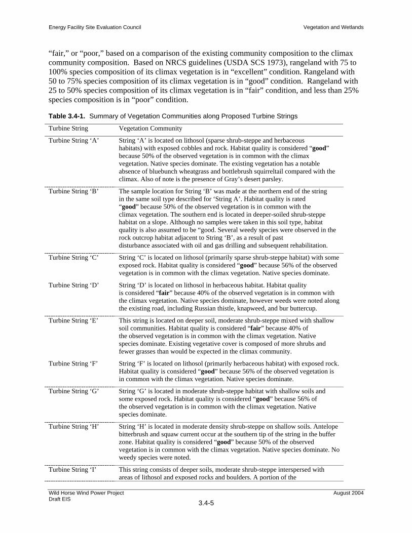
Table 3.4-1. Summary of Vegetation Communities along Proposed Turbine Strings Turbine String Vegetation Community
Turbine String ‘A’ String ‘A’ is located on lithosol (sparse shrub-steppe and herbaceous habitats) with exposed cobbles and rock. Habitat quality is considered “good” because 50% of the observed vegetation is in common with the climax vegetation. Native species dominate. The existing vegetation has a notable absence of bluebunch wheatgrass and bottlebrush squirreltail compared with the climax. Also of note is the presence of Gray’s desert parsley.
Turbine String ‘B’ The sample location for String ‘B’ was made at the northern end of the string in the same soil type described for ‘String A’. Habitat quality is rated “good” because 50% of the observed vegetation is in common with the climax vegetation. The southern end is located in deeper-soiled shrub-steppe habitat on a slope. Although no samples were taken in this soil type, habitat quality is also assumed to be “good. Several weedy species were observed in the rock outcrop habitat adjacent to String ‘B’, as a result of past disturbance associated with oil and gas drilling and subsequent rehabilitation.
Turbine String ‘C’ String ‘C’ is located on lithosol (primarily sparse shrub-steppe habitat) with some exposed rock. Habitat quality is considered “good” because 56% of the observed vegetation is in common with the climax vegetation. Native species dominate.
Turbine String ‘D’ String ‘D’ is located on lithosol in herbaceous habitat. Habitat quality is considered “fair” because 40% of the observed vegetation is in common with the climax vegetation. Native species dominate, however weeds were noted along the existing road, including Russian thistle, knapweed, and bur buttercup.
Turbine String ‘E’ This string is located on deeper soil, moderate shrub-steppe mixed with shallow soil communities. Habitat quality is considered “fair” because 40% of the observed vegetation is in common with the climax vegetation. Native species dominate. Existing vegetative cover is composed of more shrubs and fewer grasses than would be expected in the climax community.
Turbine String ‘F’ String ‘F’ is located on lithosol (primarily herbaceous habitat) with exposed rock. Habitat quality is considered “good” because 56% of the observed vegetation is in common with the climax vegetation. Native species dominate.
Turbine String ‘G’ String ‘G’ is located in moderate shrub-steppe habitat with shallow soils and some exposed rock. Habitat quality is considered “good” because 56% of the observed vegetation is in common with the climax vegetation. Native species dominate.
Turbine String ‘H’ String ‘H’ is located in moderate density shrub-steppe on shallow soils. Antelope bitterbrush and squaw current occur at the southern tip of the string in the buffer zone. Habitat quality is considered “good” because 50% of the observed vegetation is in common with the climax vegetation. Native species dominate. No weedy species were noted.
Turbine String ‘I’ This string consists of deeper soils, moderate shrub-steppe interspersed with areas of lithosol and exposed rocks and boulders. A portion of the
Energy Facility Site Evaluation Council Vegetation and Wetlands
Wild Horse Wind Power Project Draft EIS
3.4-6
August 2004
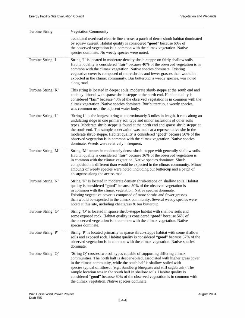
Turbine String Vegetation Community
associated overhead electric line crosses a patch of dense shrub habitat dominated by squaw current. Habitat quality is considered “good” because 60% of the observed vegetation is in common with the climax vegetation. Native species dominate. No weedy species were noted.
Turbine String ‘J’ String ‘J’ is located in moderate density shrub-steppe on fairly shallow soils. Habitat quality is considered “fair” because 40% of the observed vegetation is in common with the climax vegetation. Native species dominate. Existing vegetative cover is composed of more shrubs and fewer grasses than would be expected in the climax community. Bur buttercup, a weedy species, was noted along road.
Turbine String ‘K’ This string is located in deeper soils, moderate shrub-steppe at the south end and cobbley lithosol with sparse shrub steppe at the north end. Habitat quality is considered “fair” because 40% of the observed vegetation is in common with the climax vegetation. Native species dominate. Bur buttercup, a weedy species, was common near the adjacent water body.
Turbine String ‘L’ ‘String L’ is the longest string at approximately 3 miles in length. It runs along an undulating ridge in one primary soil type and minor inclusions of other soils types. Moderate shrub steppe is found at the north end and sparse shrub steppe at the south end. The sample observation was made at a representative site in the moderate shrub steppe. Habitat quality is considered “good” because 50% of the observed vegetation is in common with the climax vegetation. Native species dominate. Weeds were relatively infrequent.
Turbine String ‘M’ String ‘M’ occurs in moderately dense shrub-steppe with generally shallow soils. Habitat quality is considered “fair” because 36% of the observed vegetation is in common with the climax vegetation. Native species dominate. Shrub composition is different than would be expected in the climax community. Minor amounts of weedy species were noted, including bur buttercup and a patch of cheatgrass along the access road.
Turbine String ‘N’ String ‘N’ is located in moderate density shrub-steppe on shallow soils. Habitat quality is considered “good” because 50% of the observed vegetation is in common with the climax vegetation. Native species dominate. Existing vegetative cover is composed of more shrubs and fewer grasses than would be expected in the climax community. Several weedy species were noted at this site, including cheatgrass & bur buttercup.
Turbine String ‘O’ String ‘O’ is located in sparse shrub-steppe habitat with shallow soils and some exposed rock. Habitat quality is considered “good” because 56% of the observed vegetation is in common with the climax vegetation. Native species dominate.
Turbine String ‘P’ String ‘P’ is located primarily in sparse shrub-steppe habitat with some shallow soils and exposed rock. Habitat quality is considered “good” because 57% of the observed vegetation is in common with the climax vegetation. Native species dominate.
Turbine String ‘Q’ ‘String Q’ crosses two soil types capable of supporting differing climax communities. The north half is deeper-soiled, associated with higher grass cover in the climax community, while the south half is shallow-soiled with species typical of lithosol (e.g., Sandberg bluegrass and stiff sagebrush). The sample location was in the south half in shallow soils. Habitat quality is considered “good” because 60% of the observed vegetation is in common with the climax vegetation. Native species dominate.
Energy Facility Site Evaluation Council Vegetation and Wetlands
Wild Horse Wind Power Project Draft EIS
3.4-7
August 2004
Turbine String Vegetation Community
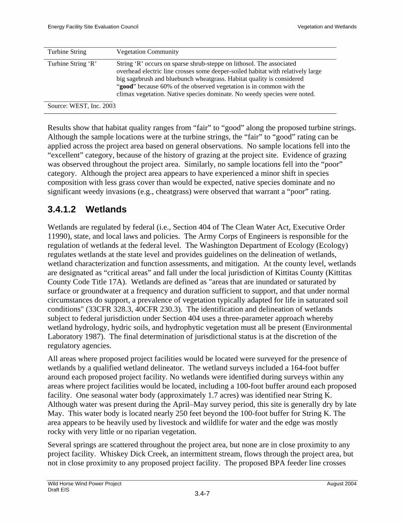
Turbine String ‘R’ String ‘R’ occurs on sparse shrub-steppe on lithosol. The associated overhead electric line crosses some deeper-soiled habitat with relatively large big sagebrush and bluebunch wheatgrass. Habitat quality is considered “good” because 60% of the observed vegetation is in common with the climax vegetation. Native species dominate. No weedy species were noted.
Source: WEST, Inc. 2003
Results show that habitat quality ranges from “fair” to “good” along the proposed turbine strings. Although the sample locations were at the turbine strings, the “fair” to “good” rating can be applied across the project area based on general observations. No sample locations fell into the “excellent” category, because of the history of grazing at the project site. Evidence of grazing was observed throughout the project area. Similarly, no sample locations fell into the “poor” category. Although the project area appears to have experienced a minor shift in species composition with less grass cover than would be expected, native species dominate and no significant weedy invasions (e.g., cheatgrass) were observed that warrant a “poor” rating.
3.4.1.2 Wetlands
Wetlands are regulated by federal (i.e., Section 404 of The Clean Water Act, Executive Order 11990), state, and local laws and policies. The Army Corps of Engineers is responsible for the regulation of wetlands at the federal level. The Washington Department of Ecology (Ecology) regulates wetlands at the state level and provides guidelines on the delineation of wetlands, wetland characterization and function assessments, and mitigation. At the county level, wetlands are designated as “critical areas” and fall under the local jurisdiction of Kittitas County (Kittitas County Code Title 17A). Wetlands are defined as "areas that are inundated or saturated by surface or groundwater at a frequency and duration sufficient to support, and that under normal circumstances do support, a prevalence of vegetation typically adapted for life in saturated soil conditions" (33CFR 328.3, 40CFR 230.3). The identification and delineation of wetlands subject to federal jurisdiction under Section 404 uses a three-parameter approach whereby wetland hydrology, hydric soils, and hydrophytic vegetation must all be present (Environmental Laboratory 1987). The final determination of jurisdictional status is at the discretion of the regulatory agencies.
All areas where proposed project facilities would be located were surveyed for the presence of wetlands by a qualified wetland delineator. The wetland surveys included a 164-foot buffer around each proposed project facility. No wetlands were identified during surveys within any areas where project facilities would be located, including a 100-foot buffer around each proposed facility. One seasonal water body (approximately 1.7 acres) was identified near String K. Although water was present during the April–May survey period, this site is generally dry by late May. This water body is located nearly 250 feet beyond the 100-foot buffer for String K. The area appears to be heavily used by livestock and wildlife for water and the edge was mostly rocky with very little or no riparian vegetation.
Several springs are scattered throughout the project area, but none are in close proximity to any project facility. Whiskey Dick Creek, an intermittent stream, flows through the project area, but not in close proximity to any proposed project facility. The proposed BPA feeder line crosses
Energy Facility Site Evaluation Council Vegetation and Wetlands
Wild Horse Wind Power Project Draft EIS
3.4-8
August 2004
Parke Creek, an intermittent stream, west of the main project area. The crossing location was investigated and no wetlands appear to be associated with Parke Creek at this location. The area supports a woody riparian zone with trees such as alder (Alnus incana) and aspen (Populus tremuloides) in the overstory and mixed shrubs (e.g., snowberry [Symphoricarpos sp.], golden current [Ribes aureum], willow [Salix sp.]) and forbs in the understory. Although riparian vegetation was present, the vegetation did not meet any of the indicators for a wetland. No hydrology indicators were observed as well. Parke Creek is somewhat channelized at this location and there was no evidence of periodic flooding or a high water table. The location is within a pasture and is heavily grazed by livestock.
3.4.1.3 Special-Status Plant Species
For the purposes of the special-status plant investigation, the survey area included all lands that would be occupied by proposed facilities and a 164-foot buffer. This included proposed turbine strings, underground and overhead electrical lines, access roads, staging areas, substation sites, potential quarry sites, and the two proposed transmission feeder line routes (BPA and PSE).
Surveys were conducted for all plant taxa listed or proposed for listing as threatened or endangered under the federal Endangered Species Act (ESA) (50 CFR 17.12) and candidates for possible future listings as threatened or endangered (67 FR 40657, June 13, 2002), and species of concern by the U.S. Fish and Wildlife Service (USDI, USFWS 2002). Surveys also included all plant taxa defined as endangered, threatened, sensitive, review, or extirpated by the Washington Natural Heritage Program (WNHP) that potentially occur in the project area. Taxa meeting the above criteria were targeted by the investigation to determine their presence or absence within the study area.
A USFWS database search identified one federally threatened plant species, Ute ladies’-tresses (Spiranthes diluvialis), and one candidate plant species, basalt daisy (Erigeron basalticus) with potential for occurrence in the project area. No other plant species of concern to the USFWS were identified. The WNHP reported one occurrence record for Hoover’s tauschia (Tauschia hooveri) in the area crossed by the proposed PSE transmission feeder line route (WNHP 2003). Additional occurrences reported by WNHP within a greater, 3-mile radius of the project area included Pauper milk-vetch, hedgehog cactus (Pediocactus simpsonii var. robustior), and one occurrence of a Wyoming big sagebrush/bluebunch wheatgrass (Artemisia tridentata ssp. wyomingensis) community.
Targeted plant species, analysis methods, and results for special-status plant surveys for the study area are presented in the Habitat Characterization and Rare Plant Resources Report (WEST, Inc. 2003). Field surveys were conducted April 21–27, May 5–9, July 25, September 24, and October 31, 2003. All vascular plants observed during floristic surveys were inventoried.
No USFWS or state-listed endangered, threatened, proposed, or candidate plant species were identified during field surveys. No habitat for Ute ladies’-tresses was observed in the study area. Limited potential habitat was found for the federal candidate species, basalt daisy. Potential habitat was found within the study area for the following federal species of concern: Columbia milkvetch (Astragalus columbianus), Hoover’s desert-parsley (Lomatium tuberosum), least phacelia (Phacelia minutissima), Seely’s silene (Silene seelyi), and Hoover’s tauschia.
Energy Facility Site Evaluation Council Vegetation and Wetlands
Wild Horse Wind Power Project Draft EIS
3.4-9
August 2004
One plant species on the Washington State Review list, hedgehog cactus, was found within the study area. Within the state, the species is of potential concern, but additional fieldwork is needed before a status can be assigned (WNHP 2002c). The Review designation carries no legal requirement for protection; however, the WNHP is interested in tracking occurrences of Review species to aid in the assignment of status. Much of the suitable habitat present in the project area (lithosol including sparse shrub-steppe and herbaceous habitats) was found to contain scattered individuals. Most of the plants were in flower at the time of the survey. The populations were extensive and extended well beyond the edge of the study corridors. Hedgehog cactus is not currently regarded as endangered, threatened, or species of concern by the USFWS.
3.4.1.4 Noxious Weeds
One genus (Centaurea) with plant species identified as noxious weeds by the Washington State Noxious Weed Control Board was recorded in the study area (main project area and the proposed feeder line routes) during floristic surveys. These plants were not identified to species level, however it is likely that one or more of these plants are listed as noxious plant species. Five species are listed (Class B) on the Kittitas County Noxious weed list and include diffuse knapweed (C. diffusa), meadow knapweed (C. pratensis), Russian knapweed (C. repens), spotted knapweed (C. maculosa), and yellow starthistle (C. solstitialis) (Kittitas County 2003).
The project area is primarily dominated by native species. Although not common, some weedy species are associated with areas of previous disturbance, such as the rocky area on top of Whiskey Dick peak previously explored for oil and gas, and areas along roads and livestock watering areas. Weedy plants (nonnative and invasive plants) observed in the project area include yellow salsify (Tragopogon dubius), blue mustard (Chorispora tenalla), cheat grass (Bromus tectorum), bulous bluegrass (Poa bulbosa), hornseed buttercup (Ranunculus testiculatus), Russian thistle (Salsola kali), common dandelion (Taraxacum officinale), fiddleneck (Amsinkia sp.). bur chervil (Anthriscus caulus), tumble mustard (Sisymbrium altissimum), and teasel (Dipsacus sylvestris).
3.4.1.5 Kittitas Valley Alternative
Vegetation communities in the project area are primarily sagebrush and grasslands consistent with the shrub-steppe region. However, there is a greater diversity of plant community types found at the Kittitas Valley site than those identified at the Wild Horse site. Lower elevations and a greater system of waterways allows for the development of riparian vegetation, conifer stands, and meadows. Similar to the Wild Horse site, lithosols communities occur commonly along the ridgetops located within the project area. These plant communities are principally composed of several different buckwheat species.
Based on wetland delineations conducted in April 2003, wetlands are rare and consist primarily of ephemeral areas within the riparian zones situated in ravines. Two wetland areas are potentially jurisdictional waters; one a flat seep drainage basin near Hayward Road and the other a stock pond that accepts high flows from Dry Creek. Although potential habitat exists within the project area for several special-status plant species, no rare plant species were identified in the project area. Many of the plant communities have been significantly modified as a result of cattle grazing, development activities, introduction of nonnative plant species, and natural
Energy Facility Site Evaluation Council Vegetation and Wetlands
Wild Horse Wind Power Project Draft EIS
3.4-10
August 2004
disturbance factors such as lightning-caused wildfire. In many places cheatgrass and noxious weeds such as diffuse knapweed are common.
3.4.1.6 Desert Claim Alternative
The Desert Claim site covers approximately 5,200 acres, of which nearly half is covered by shrub-steppe, primarily in the eastern and northern parcels. Grasslands are the second most common vegetation type, covering nearly a third of the site. There is also a small amount of irrigated agricultural land present. Approximately 200 acres are covered with lithosol associated plant communities. Wet meadows are found scattered throughout the project area in drainages and swales, and along the North Branch Canal and around stock ponds. The riparian shrub type consists of riparian areas adjacent to perennial or intermittent streams or irrigation ditches where shrubs are common, but often scattered. Some riparian forest type and a small amount of pine forest occurs in the upper elevations of the northern most portion of the site.
Seventy Six wetlands were delineated as wetland features within the Desert Claim study area. Most of the wetlands identified were palustrine or fresh water emergent wetlands, or palustrine scrub-shrub wetlands. Some were riparian wetland communities that are located around streams and other bodies of water where groundwater is close to the soil surface. Some of the wetlands are hydrologically connected to perennial streams such as Reecer Creek and/or associated riparian corridors. However none of the wetlands in the Desert Claim project area support fisheries or other protected species. Small areas of open water are scattered throughout the project area. In the project area, the wet meadows provide potential habitat for the federally listed Ute ladies’-tresses orchid, which was listed as a threatened species in 1992 (USFWS 1992). No special-status plant species have been identified within this site. Similar to the Wild Horse site, cheatgrass and knapweed are present but in general are not found over large extents of area.
3.4.1.7 Springwood Ranch Alternative
The Springwood Ranch site is situated in the western portion of the Kittitas Valley in close proximity to the Kittitas Valley site. Like the Kittitas Valley site, this area is in the transition zone between open ponderosa pine forests of the Cascade Range’s eastern slopes and the grass and shrub-steppe habitats to the east. The site is primarily grazed grasslands and agricultural lands. The agricultural lands occur along the Yakima River and extend onto the Kittitas Valley floor. Alfalfa and hay are the main crops on the site. Prominent plant communities on the site include coniferous and deciduous woodlands, grasslands and meadows, shrublands, wetland communities and riparian vegetation. Mixed stands of deciduous forest and shrub communities can be found at higher elevations on the bluffs above the Yakima River, along the draws extending from Thorp Prairie to the river, along Taneum and Swauk Creeks and along the steeper slopes adjacent to the Taneum Creek corridor. Open ponderosa pine woodlands and a few wet meadows occur in an area known as the Singing Hills.
National Wetland Inventory (NWI) maps (USFWS 1987) identify 20 wetlands on the Springwood Ranch site. These wetlands are found along the Yakima River, Taneum Creek, the eastern and northern slopes of Thorp Prairie, and along the valley floor in the southeast portion of the property. Eighteen of the wetlands are less than 3 acres while two are greater than 8 acres. Seven of the on-site wetlands are located on the western portion of the site.
Energy Facility Site Evaluation Council Vegetation and Wetlands
Wild Horse Wind Power Project Draft EIS
3.4-11
August 2004
Although there is potential habitat on the site for some special-status plant species, PHS data did not indicate any records of threatened, endangered, or sensitive plant species on the site. No on-site survey to identify special-status plants has been conducted for this EIS. Noxious weeds such as chicory (Cichorium intybus) and spotted knapweed have invaded areas of the deciduous shrub communities that occur along the Yakima River and Taneum Creek.
3.4.1.8 Swauk Valley Ranch Alternative
The Swauk Valley site is in close proximity to both the Kittitas Valley and the Springwood Ranch alternative sites. Therefore, vegetation communities found on this site are very similar to those described for each of those sites. Vegetation in the northern portion of the site is a mosaic of Ponderosa pine, mixed conifer forest, shrub understory, and grasslands (Northwest Power and Conservation Council 2004). Although some agriculture and pasture occur near Bristol on the southwest portion of the site, vegetation communities in this area are primarily sagebrush and grasslands associated with the shrub-steppe region. Similar to the Wild Horse site, plant communities associated with lithosols commonly occur along ridgetops.
Kittitas County wetland maps identify nine wetlands on the site ranging from 0.25 acre to slightly more than three acres. Several streams and small lakes are also located on the site. WDFW (2004) identified four sensitive plant communities on the east side of the site and adjacent to the unnamed perennial tributary to Swauk Creek—thyme buckwheat/Sandberg’s bluegrass, Ponderosa pine/common snowberry, Oregon oak/Geyer’s sedge, and Suksdorf Monkey Flower (WDFW 2004).
Some plant communities at this site have been disturbed by the same human and natural disturbance mechanisms described for Wild Horse and the other alternative sites.
The Nature Conservancy of Washington holds a conservation easement on Lookout Mountain on the northern portion of the site.
3.4.2 Impacts of Proposed Action Both temporary and permanent impacts of the project to vegetation would occur during construction of any of the scenarios (i.e., 104-turbine/3-MW, 136-turbine/1.5-MW, 158-turbine/1-MW) under the proposed project. During operations, permanent impacts would remain for the life of the project while temporary impacts would be restored over time as native vegetation recovers.
Under the different design scenarios, the length or width of project components, including roads, substations, operation and maintenance (O&M) facilities, rock quarries, underground or overhead lines, permanent met towers, batch plant, or rock crusher would have the same footprints. These components remain unchanged under all scenarios and would have similar impacts under all scenarios.
The permanently disturbed acreage would differ only by the different number of wind turbine foundations required. There would be a total difference of 0.12 acre of permanent impact between the three scenarios. A summary of acreages permanently and temporarily disturbed under each scenario by the different project elements are presented in Table 2-1 in Section 2.21, Project Overview. The acreages for temporary and permanent impacts on vegetation
Energy Facility Site Evaluation Council Vegetation and Wetlands
Wild Horse Wind Power Project Draft EIS
3.4-12
August 2004
communities are summarized in Table 3.4-2 below. The acreages of temporary disturbance on vegetation communities differ depending on the number of laydown areas required for each scenario. Because the 158-turbine/1-MW scenario would install more wind turbines, it would require a larger temporary impact area for wind turbine laydown and assembly than the other two scenarios.
Table 3.4-2. Summary of Potential Construction Impacts on Vegetation, Wetlands, and Special-Status Plants
104 Turbines/3 MW 136 Turbines/1.5 MW (Most Likely Scenario) 158 Turbines/1 MW
Vegetation
Temporary vegetation removal and habitat loss
289.5 acres disturbed area 356.0 acres disturbed area
401.4 acres disturbed area
Permanent vegetation removal and habitat loss
164.7 acres disturbed area 164.7 acres disturbed area
164.6 acres disturbed area
Impact to lithosols 61 acres disturbed 61 acres disturbed 61 acres disturbed Wetlands
Impacts on wetlands None None None
Special-Status Plant Species
Impacts on federal (ESA) or state listed plant species
Unlikely Unlikely Unlikely
Impacts on federally listed “species of concern”
Negligible Negligible Negligible
Source: Wind Ridge Power Partners LLC 2004
3.4.2.1 Construction Impacts
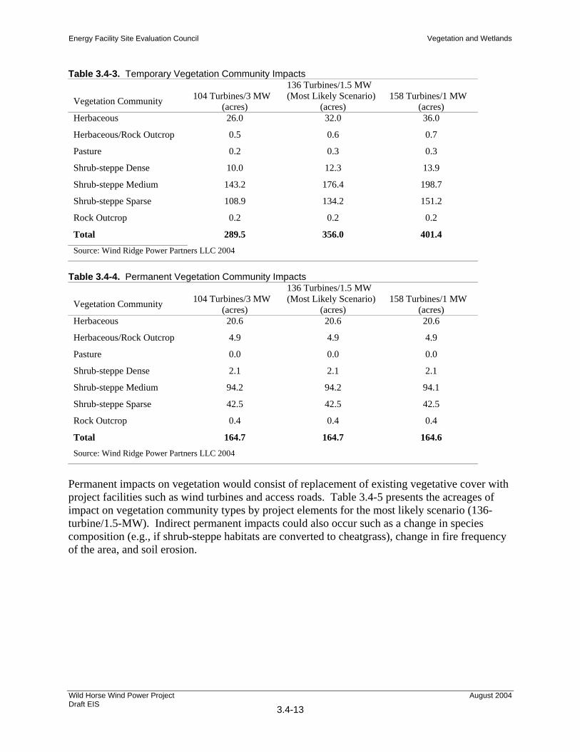
Tables 3.4-3 and 3.4-4 summarize temporary and permanent impacts that would occur to vegetation communities in the project area under the three scenarios. Six of the eight plant community types mapped in the main project area would be affected. Vegetation types that would be affected include herbaceous, herbaceous/rock outcrop, shrub-steppe dense, shrub-steppe medium, shrub-steppe sparse, and rock outcrop. Pine forest and woody riparian habitats would not be impacted by project facilities, either temporarily or permanently. Vegetation along the BPA and PSE transmission line corridors that would be affected include herbaceous, pasture, shrub-steppe dense, shrub-steppe medium, shrub-steppe sparse, and rock outcrop. Of the approximately 356 acres of temporary impact, approximately 323 acres (91%) would occur in shrub-steppe. Of the approximately 165 acres of permanent impacts, the majority (approximately 139 acres or 84%) would occur in shrub-steppe.
Energy Facility Site Evaluation Council Vegetation and Wetlands
Wild Horse Wind Power Project Draft EIS
3.4-13
August 2004
Table 3.4-3. Temporary Vegetation Community Impacts
Vegetation Community 104 Turbines/3 MW (acres)
136 Turbines/1.5 MW (Most Likely Scenario)
(acres) 158 Turbines/1 MW
(acres) Herbaceous 26.0 32.0 36.0
Herbaceous/Rock Outcrop 0.5 0.6 0.7
Pasture 0.2 0.3 0.3
Shrub-steppe Dense 10.0 12.3 13.9
Shrub-steppe Medium 143.2 176.4 198.7
Shrub-steppe Sparse 108.9 134.2 151.2
Rock Outcrop 0.2 0.2 0.2
Total 289.5 356.0 401.4
Source: Wind Ridge Power Partners LLC 2004
Table 3.4-4. Permanent Vegetation Community Impacts
Vegetation Community 104 Turbines/3 MW (acres)
136 Turbines/1.5 MW (Most Likely Scenario)
(acres) 158 Turbines/1 MW
(acres) Herbaceous 20.6 20.6 20.6
Herbaceous/Rock Outcrop 4.9 4.9 4.9
Pasture 0.0 0.0 0.0
Shrub-steppe Dense 2.1 2.1 2.1
Shrub-steppe Medium 94.2 94.2 94.1
Shrub-steppe Sparse 42.5 42.5 42.5
Rock Outcrop 0.4 0.4 0.4
Total 164.7 164.7 164.6 Source: Wind Ridge Power Partners LLC 2004
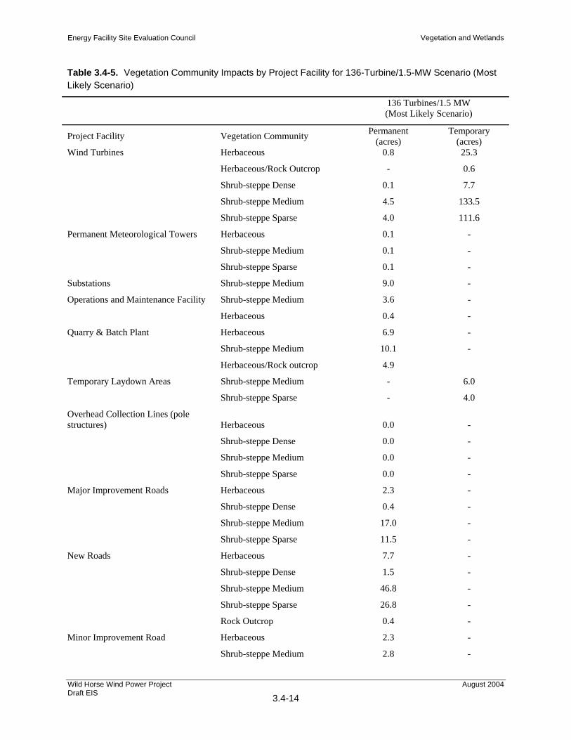
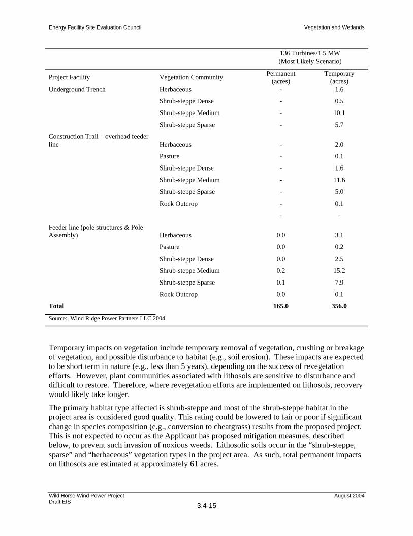
Permanent impacts on vegetation would consist of replacement of existing vegetative cover with project facilities such as wind turbines and access roads. Table 3.4-5 presents the acreages of impact on vegetation community types by project elements for the most likely scenario (136-turbine/1.5-MW). Indirect permanent impacts could also occur such as a change in species composition (e.g., if shrub-steppe habitats are converted to cheatgrass), change in fire frequency of the area, and soil erosion.
Energy Facility Site Evaluation Council Vegetation and Wetlands
Wild Horse Wind Power Project Draft EIS
3.4-14
August 2004
Table 3.4-5. Vegetation Community Impacts by Project Facility for 136-Turbine/1.5-MW Scenario (Most Likely Scenario)
136 Turbines/1.5 MW (Most Likely Scenario)
Project Facility Vegetation Community Permanent (acres)
Temporary (acres)
Wind Turbines Herbaceous 0.8 25.3
Herbaceous/Rock Outcrop - 0.6
Shrub-steppe Dense 0.1 7.7
Shrub-steppe Medium 4.5 133.5
Shrub-steppe Sparse 4.0 111.6
Permanent Meteorological Towers Herbaceous 0.1 -
Shrub-steppe Medium 0.1 -
Shrub-steppe Sparse 0.1 -
Substations Shrub-steppe Medium 9.0 -
Operations and Maintenance Facility Shrub-steppe Medium 3.6 -
Herbaceous 0.4 -
Quarry & Batch Plant Herbaceous 6.9 -
Shrub-steppe Medium 10.1 -
Herbaceous/Rock outcrop 4.9
Temporary Laydown Areas Shrub-steppe Medium - 6.0
Shrub-steppe Sparse - 4.0
Overhead Collection Lines (pole structures) Herbaceous 0.0 -
Shrub-steppe Dense 0.0 -
Shrub-steppe Medium 0.0 -
Shrub-steppe Sparse 0.0 -
Major Improvement Roads Herbaceous 2.3 -
Shrub-steppe Dense 0.4 -
Shrub-steppe Medium 17.0 -
Shrub-steppe Sparse 11.5 -
New Roads Herbaceous 7.7 -
Shrub-steppe Dense 1.5 -
Shrub-steppe Medium 46.8 -
Shrub-steppe Sparse 26.8 -
Rock Outcrop 0.4 -
Minor Improvement Road Herbaceous 2.3 -
Shrub-steppe Medium 2.8 -
Energy Facility Site Evaluation Council Vegetation and Wetlands
Wild Horse Wind Power Project Draft EIS
3.4-15
August 2004
136 Turbines/1.5 MW (Most Likely Scenario)
Project Facility Vegetation Community Permanent (acres)
Temporary (acres)
Underground Trench Herbaceous - 1.6
Shrub-steppe Dense - 0.5
Shrub-steppe Medium - 10.1
Shrub-steppe Sparse - 5.7
Construction Trail—overhead feeder line Herbaceous - 2.0
Pasture - 0.1
Shrub-steppe Dense - 1.6
Shrub-steppe Medium - 11.6
Shrub-steppe Sparse - 5.0
Rock Outcrop - 0.1
- -
Feeder line (pole structures & Pole Assembly) Herbaceous 0.0 3.1
Pasture 0.0 0.2
Shrub-steppe Dense 0.0 2.5
Shrub-steppe Medium 0.2 15.2
Shrub-steppe Sparse 0.1 7.9
Rock Outcrop 0.0 0.1
Total 165.0 356.0
Source: Wind Ridge Power Partners LLC 2004
Temporary impacts on vegetation include temporary removal of vegetation, crushing or breakage of vegetation, and possible disturbance to habitat (e.g., soil erosion). These impacts are expected to be short term in nature (e.g., less than 5 years), depending on the success of revegetation efforts. However, plant communities associated with lithosols are sensitive to disturbance and difficult to restore. Therefore, where revegetation efforts are implemented on lithosols, recovery would likely take longer.
The primary habitat type affected is shrub-steppe and most of the shrub-steppe habitat in the project area is considered good quality. This rating could be lowered to fair or poor if significant change in species composition (e.g., conversion to cheatgrass) results from the proposed project. This is not expected to occur as the Applicant has proposed mitigation measures, described below, to prevent such invasion of noxious weeds. Lithosolic soils occur in the “shrub-steppe, sparse” and “herbaceous” vegetation types in the project area. As such, total permanent impacts on lithosols are estimated at approximately 61 acres.
Energy Facility Site Evaluation Council Vegetation and Wetlands
Wild Horse Wind Power Project Draft EIS
3.4-16
August 2004
Very few trees occur in the project area, and no tree removal is anticipated. The BPA transmission feeder line corridor would cross Parke Creek where deciduous trees are present. This is the only riparian habitat that could potentially be affected by the WHWPP. The Applicant has indicated that a permanent maintenance trail would not be required in the Parke Creek riparian zone and therefore, it is expected that no trees would need to be removed. In addition, the transmission poles will be located at least 200 feet back from the stream bank on either side and there will be no heavy equipment used in the streambed or riparian corridor for construction. WDFW has reviewed the proposed crossing site and construction techniques and have indicated that no hydraulic permit would be required. A copy of this letter is included in Appendix A.
Wetlands
No wetlands occur in or near areas where project facilities are proposed or construction activities would occur under any of the three scenarios. Therefore, no construction impacts on wetlands are anticipated. In addition, no construction would take place within 200 feet of the stream bank at the proposed crossing of Parke Creek.
Special-Status Plant Species
Because of the absence of known populations within the project area, no construction-related impacts are anticipated to any federally or state-listed endangered, threatened, proposed, or candidate plant species.
Limited impacts are anticipated, however, to one species on the Washington State Review list, hedgehog cactus. Ground disturbance related to construction of the proposed project could cause direct adverse impacts on individuals if they are located within the impact footprint. However, because of the large number of individuals observed, their frequency in preferred habitats, and the high likelihood that many more individuals occur in the area adjacent to the survey corridors, the project is not expected to significantly impact the species’ viability in the project area. An estimated 10% of the individuals in the project area could be directly impacted by the project. This level of direct impact is not anticipated to jeopardize the continued existence of the local population, or lead to the need for state or federal listing.
In addition to direct impacts from ground disturbing activities, the project also has the potential to impact hedgehog cactus indirectly if the project leads to the degradation of habitat in the area through the introduction and spread of noxious weeds or the increase of human presence in the area. Although little is known about how hedgehog cactus responds to competition from nonnative species, it is safe to assume that significant increases in noxious weeds in the area could adversely impact the species. At the present time, the lithosolic habitat where hedgehog cactus is found is relatively intact. In addition, mitigation measures to prevent and minimize the spread of noxious weeds will be implemented during construction. Furthermore, uncontrolled access to the project area could increase the possibility of cactus collectors on site. Collection of hedgehog cactus for gardens has been cited as a reason for decline of the species (Taylor 1992). Access to the project area will be controlled during construction and operations and will likely result in a lower level of human activity within the project area than is currently occurring.
Energy Facility Site Evaluation Council Vegetation and Wetlands
Wild Horse Wind Power Project Draft EIS
3.4-17
August 2004
Noxious Weeds
Most noxious and invasive plant species are aggressive pioneer species that have a competitive advantage over native species on disturbed sites. Therefore, all areas disturbed by the project are potential habitat for noxious and invasive plant species, particularly for those species previously observed or known to occur in the project area. The introduction of new noxious plant species from other areas can occur from construction equipment and other vehicles transporting seeds onto the project site. Once established in an area, negative impacts can include one or more of the following, depending on the species, degree of invasion, and control measures:
displacement of native plant species;
reduction in plant diversity;
changes in plant community functions;
alteration of wetland and riparian functions;
loss of wildlife habitat;
reduction in livestock forage;
changes in fire frequency
increased soil erosion and sedimentation;
increased control and eradication costs to local communities.
3.4.2.2 Operation and Maintenance Impacts
Operational impacts on vegetation communities would include shading associated with turbine towers and the O&M building, as well as impacts caused by increased dust generated by travel on access roads, potential changes in fire frequency patterns, and the potential introduction of invasive plant species that could encourage a shift in native plant community composition (see Table 3.4-6). Although as many as 158 turbines would be constructed under the 158-turbine/1-MW scenario, there should be no noticeable effect from shading on the underlying vegetation from any of the proposed scenarios. Dust generated from vehicles traveling the access roads would be similar under all scenarios since the road length is the same under all three scenarios. Scheduled maintenance is typically performed only every 6 months on each turbine. Therefore, potential impacts on vegetation are expected to be negligible.
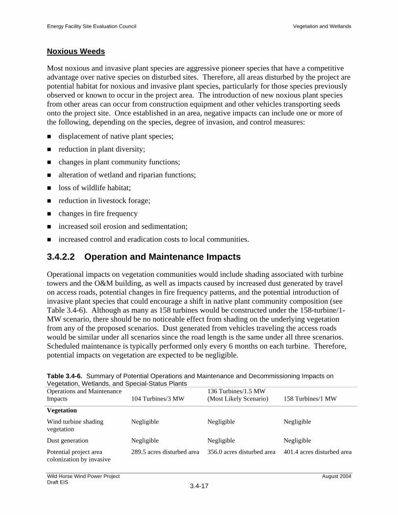
Table 3.4-6. Summary of Potential Operations and Maintenance and Decommissioning Impacts on Vegetation, Wetlands, and Special-Status Plants Operations and Maintenance Impacts 104 Turbines/3 MW
136 Turbines/1.5 MW (Most Likely Scenario) 158 Turbines/1 MW
Vegetation
Wind turbine shading vegetation
Negligible Negligible Negligible
Dust generation Negligible Negligible Negligible
Potential project area colonization by invasive
289.5 acres disturbed area 356.0 acres disturbed area 401.4 acres disturbed area
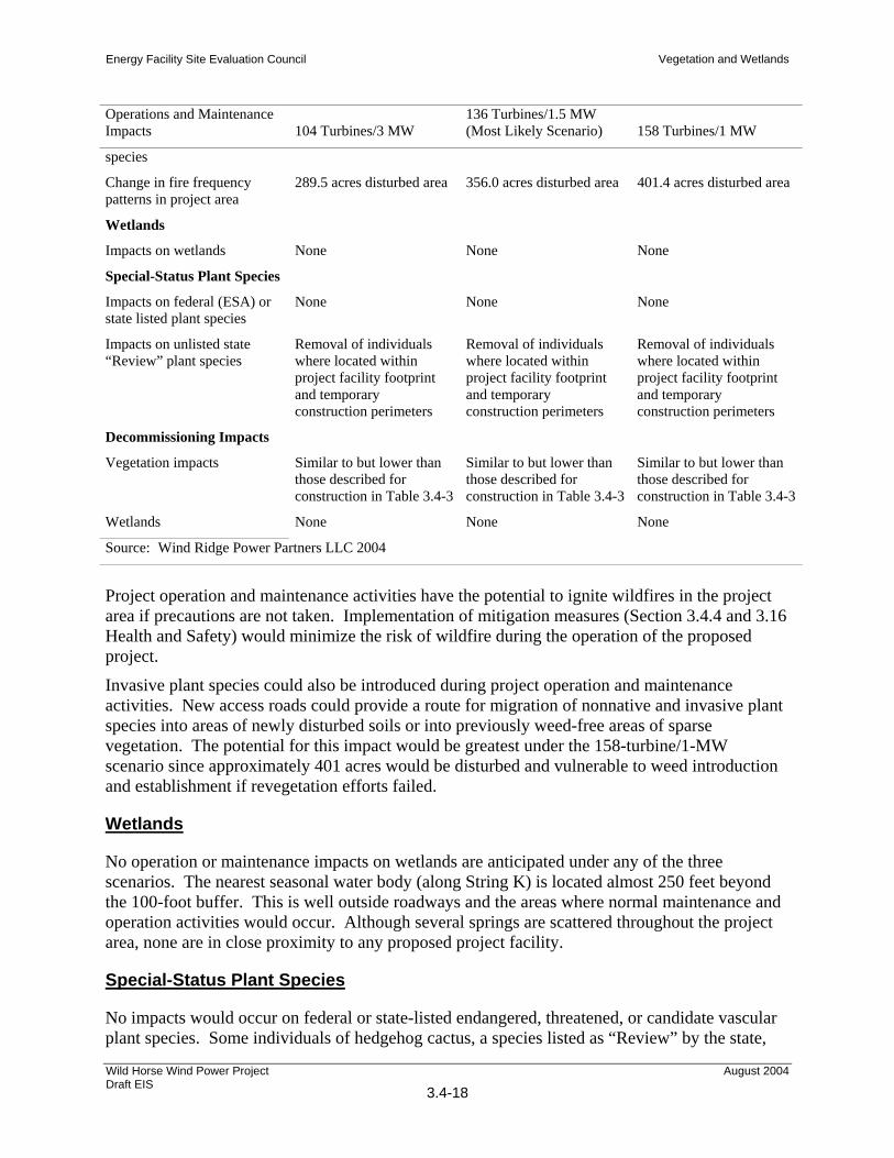
Energy Facility Site Evaluation Council Vegetation and Wetlands
Wild Horse Wind Power Project Draft EIS
3.4-18
August 2004
Operations and Maintenance Impacts 104 Turbines/3 MW
136 Turbines/1.5 MW (Most Likely Scenario) 158 Turbines/1 MW
species
Change in fire frequency patterns in project area
289.5 acres disturbed area 356.0 acres disturbed area 401.4 acres disturbed area
Wetlands
Impacts on wetlands None None None
Special-Status Plant Species
Impacts on federal (ESA) or state listed plant species
None None None
Impacts on unlisted state “Review” plant species
Removal of individuals where located within project facility footprint and temporary construction perimeters
Removal of individuals where located within project facility footprint and temporary construction perimeters
Removal of individuals where located within project facility footprint and temporary construction perimeters
Decommissioning Impacts
Vegetation impacts Similar to but lower than those described for construction in Table 3.4-3
Similar to but lower than those described for construction in Table 3.4-3
Similar to but lower than those described for construction in Table 3.4-3
Wetlands None None None
Source: Wind Ridge Power Partners LLC 2004
Project operation and maintenance activities have the potential to ignite wildfires in the project area if precautions are not taken. Implementation of mitigation measures (Section 3.4.4 and 3.16 Health and Safety) would minimize the risk of wildfire during the operation of the proposed project.
Invasive plant species could also be introduced during project operation and maintenance activities. New access roads could provide a route for migration of nonnative and invasive plant species into areas of newly disturbed soils or into previously weed-free areas of sparse vegetation. The potential for this impact would be greatest under the 158-turbine/1-MW scenario since approximately 401 acres would be disturbed and vulnerable to weed introduction and establishment if revegetation efforts failed.
Wetlands
No operation or maintenance impacts on wetlands are anticipated under any of the three scenarios. The nearest seasonal water body (along String K) is located almost 250 feet beyond the 100-foot buffer. This is well outside roadways and the areas where normal maintenance and operation activities would occur. Although several springs are scattered throughout the project area, none are in close proximity to any proposed project facility.
Special-Status Plant Species
No impacts would occur on federal or state-listed endangered, threatened, or candidate vascular plant species. Some individuals of hedgehog cactus, a species listed as “Review” by the state,
Energy Facility Site Evaluation Council Vegetation and Wetlands
Wild Horse Wind Power Project Draft EIS
3.4-19
August 2004
may be trampled during operation and maintenance activities where maintenance crews walk around the facilities. Individuals along access roads may be covered by dust generated by passing traffic. Individual plants may be collected by tourists, or by people recreating in the area.
3.4.2.3 Decommissioning Impacts
Impacts on vegetation from decommissioning the WHWPP would be similar to but should be less than impacts described for construction, assuming all access roads remain in place. Decommissioning vehicles would travel on established roadways generating dust and potentially introducing or spreading nonnative, invasive, or noxious weeds. Vegetation surrounding project facilities (i.e., turbine, meteorological, and transmission towers) to be removed would likely be affected to the same extent as identified for construction. Reclamation procedures would be based on site-specific requirements and techniques commonly used at the time the project area would be reclaimed and would include regrading, adding topsoil, and revegetating disturbed areas with native plant species.
3.4.3 Impacts of Alternatives
3.4.3.1 Impacts of Off-Site Alternatives
Kittitas Valley Alternative
Construction impacts to vegetation communities located at the Kittitas Valley site would be similar to those described for the Wild Horse site, except there is a greater diversity of habitats that would be affected. There would be a loss of approximately 93 to 118 acres of vegetation from construction activities. The majority of vegetation affected, from 311 to 371 acres, would be temporarily disturbed for up to 1 year. Grassland, shrub-steppe, sagebrush, deciduous shrub, riparian vegetation, and conifer forest communities would be cleared for project operations. Loss of 36–150 acres of sensitive lithosol habitat would be considered an adverse effect of the project. Grassland, shrub-steppe, and low sagebrush communities would be most affected by project disturbance. These areas would be replanted and restored after completion of construction activities. However, use of heavy equipment during the construction phase could cause soil compaction that may affect long-term plant survival and growth. Other potential impacts on vegetation include dust effects and increased potential for wildfires.
Up to 185 square feet of one wetland would be affected by filling or grading activities during construction. The potential impacts to vegetation from the introduction, colonization, and spread of noxious weed species and the corresponding control measures would be similar to those described for the Wild Horse site.
Impacts associated with project operations would be similar to those described for the Wild Horse site, and would include shading from the turbine towers, increased dust generated by travel on graveled roadways, potential changes in fire frequency patterns, and potential introduction of invasive weed species. No impacts on wetlands would occur during project operations if proper drainage, erosion-control plans, and stormwater management practices are implemented.
Energy Facility Site Evaluation Council Vegetation and Wetlands
Wild Horse Wind Power Project Draft EIS
3.4-20
August 2004
There would be no direct impacts on endangered plant species during the construction or operation and maintenance phases of the project.
Desert Claim Alternative
Approximately 78 acres of existing vegetation would be permanently removed for project facilities at the Desert Claim site. Permanent loss of vegetation would occur in shrub-steppe, grassland, riparian shrub, riparian forest, and wet meadow habitats. The majority of construction impact, over 90%, would occur in shrub-steppe and grassland. Approximately 3 acres of land currently used for agricultural purposes would also be permanently converted to land occupied by the project facility. In addition, 311 acres of vegetation would be temporarily disturbed.
Approximately 9 acres of wetland area would be permanently displaced by project facilities, with an additional 16 acres temporarily disturbed by construction. No impacts to special-status plant species are anticipated. Similar to the Wild Horse site, all areas disturbed by project construction would be vulnerable to invasion by nonnative or noxious weed species. Control measures similar to those described for Wild Horse would be implemented.
Impacts associated with operation and maintenance activities would be similar those described for the Wild Horse site.
Springwood Ranch Alternative
Impacts to vegetation communities at the Springwood Ranch site would be similar to, but less than, those described for the Wild Horse site and the other alternatives. It is estimated that approximately 30 acres of existing vegetation would be permanently displaced to accommodate wind energy facilities with an additional 110 acres temporarily disturbed for construction. Grasslands (generally used for grazing now) and shrublands would be the vegetation communities most affected by the project. Portions of woodland in the northwest corner of the site could possibly be affected by clearing for construction of project facilities. No other plant communities would be temporarily or permanently disturbed.
Construction of access roads and collection cable routes through or near wetland areas would be the two main activities affecting wetlands. Five wetlands lie in the northern and western portions of the site and would be subject to temporary disturbance by construction activity or displacement by permanent project facilities. Micro-siting might be able to avoid some potential wetland impacts. The total area of potential wetland impacts has not been determined.
Based on current available information, no impact on federal or state threatened, endangered, or sensitive plant species would be expected to occur as a result of the project. All areas disturbed by the project are potential habitat for noxious and invasive species. Control measures would be implemented to prevent significant impacts.
Impacts from operation and maintenance activities would be similar to those described for the Wild Horse site.
Swauk Valley Ranch Alternative
Construction impacts would be similar to, but less than, those described for the Wild Horse and Kittitas Valley sites. Approximately 97 acres would be temporarily disturbed for up to 1 year.
Energy Facility Site Evaluation Council Vegetation and Wetlands
Wild Horse Wind Power Project Draft EIS
3.4-21
August 2004
Habitats that would be most affected by the project include grassland, shrub-steppe, and low sagebrush communities. Sensitive lithosol habitat would be potentially impacted in areas where shrub-steppe is disturbed. As with the project proposed at the Wild Horse site, these areas would be replanted and restored after completion of construction activities. Success of restoration efforts would depend on factors such as extent of soil compaction, extent of lithosols impacted, potential changes in fire frequency patterns, and the introduction of invasive plant species.
It is not known if there would be impacts to wetlands from construction. Micro-siting could reduce wetland impacts by placing project facilities outside wetland buffers. The project could potentially affect 17 acres of a thyme buckwheat/Sandberg’s bluegrass plant community located adjacent to the south site boundary. As currently proposed, five wind turbines would be located within the designated sensitive area.
Impacts from operations and maintenance activities would be similar to those described for the Wild Horse site. No impacts on wetlands are anticipated during project operations if proper management practices are implemented.
3.4.3.2 Impacts of No Action Alternative
Under the No Action Alternative, the project would not be constructed or operated. However, development of a different nature could occur under Kittitas County’s existing Comprehensive Plan and zoning regulations for the project area. Depending on the location, type, and magnitude of future developments at the project site, impacts on vegetation, wetlands, or to threatened or endangered plant species could be similar to or even greater than the proposed action.
Other power generation facilities could be constructed and operated in the region to meet the long-term need for power Constructing a base load gas-fired turbine generator, developing and extracting natural gas, and constructing natural gas pipelines to provide fuel to the generating facility could create impacts on vegetation, wetlands, and threatened and endangered plant species. Construction of renewable energy facilities would also result in impacts to vegetation, wetlands, and threatened and endangered plant species. The significance of such impacts would depend on the site-specific location and design of the facility.
It is likely that cattle grazing would continue to be the primary agricultural activity in the vicinity of Whiskey Dick Mountain. Vegetation communities would continue to mature, however, wherever cattle grazing disturbed shrub-steppe and sensitive plant assemblages associated with lithosols and sensitive springs, wetlands, and riparian habitats, these plant communities would be vulnerable to nonnative and noxious weed establishment.
3.4.4 Mitigation Measures Shrub steppe is considered a priority habitat by WDFW. As such, the Applicant has proposed to mitigate all permanent and temporary impacts on vegetation caused by the proposed project in accordance with the guidelines outlined in the WDFW Wind Power Guidelines (WDFW, August 2003) for siting and mitigating wind power projects east of the Cascades. A mitigation parcel has been identified within the 8,600-acre project area. The mitigation parcel is located in T18N, R21E, Section 27 and is approximately 600 acres in size. A portion of this section (String L follows a ridgeline that dissects Section 27 from north to south) would be excluded from mitigation and developed as part of the project. The WDFW has indicated that the Applicant’s
Energy Facility Site Evaluation Council Vegetation and Wetlands
Wild Horse Wind Power Project Draft EIS
3.4-22
August 2004
proposed mitigation is responsive to discussions with WDFW (WDFW 2004; see Appendix A). The 600-acre mitigation parcel would meet or exceed the required habitat replacement ratios under the WDFW Wind Power Guidelines for any of the three scenarios proposed. The Applicant has agreed to fence this parcel to exclude livestock grazing, if grazing practices continue on adjacent properties at the time the project goes into operation. In addition to Section 27, the Applicant proposes to fence several springs within the project area to eliminate livestock degradation. Fencing used for the mitigation parcel and the springs will be designed to keep livestock out but allow game species to cross. The Applicant intends to coordinate with WDFW regarding fence specifications.
As noted above, WDFW has prepared a set of guidelines for wind power projects east of the Cascades to provide guidance for siting and mitigation. These guidelines were followed during selection of Section 27 as a mitigation site for the project. Section 27 provides opportunity for “like-kind” replacement habitat of equal or higher habitat value than the impacted area and it occurs in the same geographical region as the impacted habitat. Furthermore, the Applicant has an option to purchase the property if the project goes forward, and the Applicant will provide legal protection and protection from degradation for the life of the project. Consistent with WDFW’s guidelines, permanent impacts on habitat would be replaced at a ratio equal to or greater than 1:1 for grassland and 2:1 for shrub-steppe.
Use of Section 27 as a mitigation parcel would result in protection of an approximately 1-mile segment of Whiskey Dick Creek near its headwaters. Protection of waterways and their adjacent riparian habitat provide additional benefits beyond replacement of like-kind habitat at agreed upon ratios. Protection of this segment of Whiskey Dick Creek provides benefits for water quality, wildlife, and species diversity. In addition, Section 27 is adjacent to state-owned lands. Washington Department of Natural Resources (WDNR) administers Section 34 to the south and WDFW administers Section 26 to the east. Use of Section 27 for mitigation will provide continuity of habitat with these adjacent state-owned sections. Finally, a variety of habitat types that occur in the general project area are found in Section 27, so a diversity of habitat types would be preserved. These include shrub-steppe (moderate and dense), herbaceous, herbaceous/rock outcrop, and woody riparian.
In addition to the above-mentioned mitigation parcel, additional mitigation measures contained in the WDFW guidelines would be implemented. These guidelines include implementing a WDFW approved restoration plan for the impacted areas that will include:
site preparation,
reseeding with appropriate vegetation,
noxious weed control, and
protection from degradation
Best management practices (BMPs) will be implemented during construction, as discussed in Sections 3.1 Earth and 3.3 Water, to control erosion and surface water runoff, and as presented below for noxious weed control.
Energy Facility Site Evaluation Council Vegetation and Wetlands
Wild Horse Wind Power Project Draft EIS
3.4-23
August 2004
3.4.4.1 Wetlands
Since no impacts on wetlands are anticipated, no mitigation is proposed. During the design of the project, all project facilities, including access roads, electric lines, and turbine strings, were intentionally laid out to avoid the limited water features in the project area (particularly springs).
3.4.4.2 Special-Status Plants
The only special-status plant species that may be impacted by the project is hedgehog cactus, a Washington State Review listed species. Access to the site will be controlled during both construction and operations, which should provide greater protection than is currently afforded to this species. As collection of this species for gardens has been cited as a reason for its decline, if such collection becomes a problem at the project site despite the controlled access, the Applicant proposed to post signage indicating that collection of any plants in the project area is prohibited.
3.4.4.3 Noxious Weeds
To avoid, minimize, or reduce the impacts of noxious weeds, the Applicant proposes the following mitigation measure:
The contractor will clean construction vehicles prior to bringing them in to the project area from outside areas.
Disturbed areas will be reseeded as quickly as possible with native species.
Seed mixes will be selected in consultation with WDFW and Kittitas County Weed Control Board.
If hay is used for sediment control or other purposes, hay bales will be certified weed free.
Access to the site will be controlled which may result in a lower level of disturbance and fewer opportunities for noxious weeds to be introduced and/or spread.
Noxious weeds that may establish themselves as a result of the project will be actively controlled in consultation with the Kittitas County Weed Control Board.
3.4.5 Significant Unavoidable Adverse Impacts With implementation of the above-mentioned mitigation measures and avoidance of wetland and riparian areas, no significant unavoidable adverse impacts are anticipated on vegetation resources and wetlands from the proposed WHWPP. Total temporary upland vegetation disturbance would range from 289.5 acres for the 104-turbine/3-MW scenario to 401.4 acres for the 158-turbine/1-MW scenario. Total permanent vegetation impacts would be very similar (0.12 acre difference between scenarios). The temporary and permanent impacts on plant communities within the project site would be compensated for by the mitigation proposal to purchase and protect an approximately 600-acre parcel with equal or better functional habitat characteristics as the project area.


![[Vegetation and Remote Sensing] Vegetation](https://img.pdfslide.net/doc/110x75/577cdfd71a28ab9e78b21a32/vegetation-and-remote-sensing-vegetation.jpg)