Embed Size (px)
Citation preview
Nepal
New peaks in 2001. A press release fromKathmandu on April 10 declared that HisMajesty’s Government would open 15 newpeaks within one week and 50 more duringthe post monsoon season. However, after thespring season was underway the Governmentannounced the opening of just nine peakswith immediate effect. This is the first timeany peaks have been opened while a climbingseason was in progress. These nine peakscomprised six in the Khumbu and one eachin the Manaslu, Annapurna, and Dhaulagiriregions. The peaks listed were: Lhotse Middle(8413m), Peak 38 (Shartse II: 7590m),Hungchi (7136m), Numri (6677m), Teng Kangpoche (6500m), and Nhe Serku (5927m), all inthe Khumbu, plus P2 (6251m) in the Manaslu region, Thorang Peak (5751m) in the Annapurnaregion, and Thapa Peak (6012m) in the Dhaulagiri region.
New Peaks for 2002. The Government of Nepal officially announced the opening of 103 additional peaks to foreign expeditions. The announcement came on Christmas Eve 2001 andtook effect from March 1, 2002. Unlike the 10 peaks brought on to the list in 1998 (Visit NepalYear) for a two-year period only, it is reported these new additions will be permanent. Speakingin Kathmandu, Ganesh Raj Karki, Chief of the Mountaineering Department at the Ministry ofCulture, Tourism and Civil Aviation, said,“This would not only help promote Nepal as the primedestination for mountaineering but also help development of the areas around these mountains.”
Together with the nine peaks added to the list in spring 2001, mountaineers will now beallowed to climb 263 peaks throughout the Nepal Himalaya. Additionally, the Government hassubstantially eased the financial and administrative burden on many future expeditions by abol-ishing the need for a Liaison Officer on peaks below 6500m. This means out of the 263 avail-able peaks, from now on only 89 will require an LO.
For a number of years the Expeditions Commission of the UIAA, in its negotiations withthe Nepalese authorities, has continually recommended a complete revision of the now out-dated LO system in Nepal and advocated an increase the number of permitted peaks. It sub-mitted a selection of proposed new mountains. Many of these now appear in a new list of openpeaks, drawn up from recommendations submitted by a study team from the CentralDepartment of Geography, Tribhuvan University, following request by the Government.
An attempt has been made to group these peaks according to the principle ranges orHimals as defined in the Nepal Himalaya Inventory. These groups have been tabled from eastto west. However, as no coordinates have been received at the time of writing, it is likely thatsome of these entries will be out of sequence, particularly those of the rarely visited DamodarHimal, where two Pokhahans of almost equal height are recorded.
TH E AM E R I C A N AL P I N E JO U R NA L, 2002396
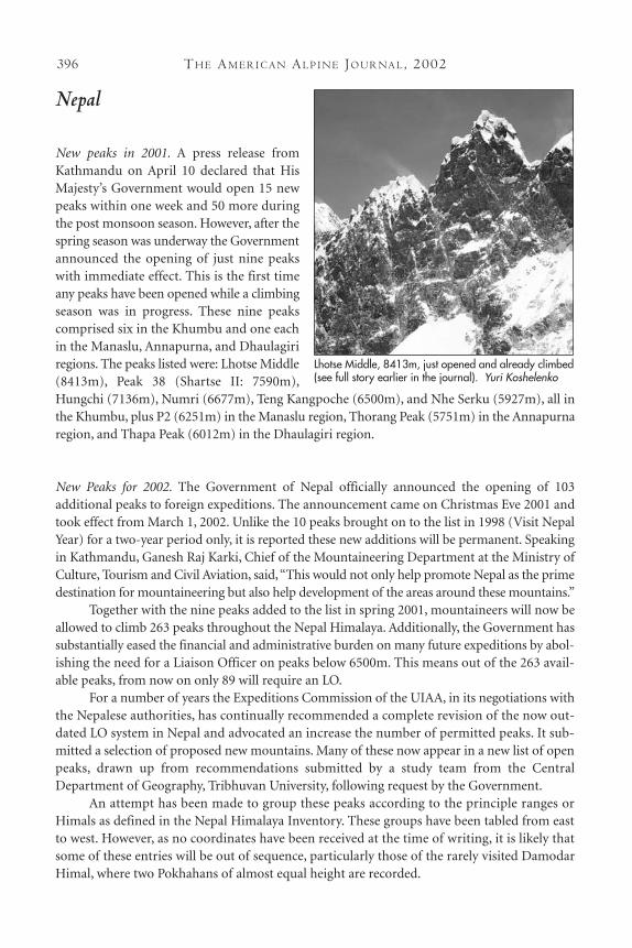
Lhotse Middle, 8413m, just opened and already climbed(see full story earlier in the journal). Yuri Koshelenko

EAST NEPAL
KANGCHENJUNGA REGION
Kangchenjunga Himal Talung 7349mThaple Shikhar (Cross Peak) 6341mRamtang Chang 6750mChang Himal/Ramtang N(Wedge Peak) 6750m
Annidesha HimalAnnidesh Chuli 6960mWhite Wave 5809mMerra 6335mMojca Peak 6032m
Khumbhakarna HimalSobitongje 6670mPhole 6645mKyabura (Khabur) 6332mBokta Peak 6143mLumba Sumba Peak 5672mLumba Samba 5670m
Janak HimalLang Chung Kang 6475mDomekhan (Dome Kang ) 7264mJanak 7090mLoshar II (Lashar II) 6860mLoshar I (Lashar I) 6930mDazaney (Dzanye Peak) 6710mGhhanyala Hies 6779mMdm Peak 6270mSat Peak 6220mChabuk (Tsajirip) 6960mPandra 6850mSyaokang 5960mDanga 6355mSharphu 4 6433mSharphu 1 7070mSharphu 2 6154mSharphu 3 6885mSharphu 5 6328mSharphu 6 6076m
MAKALU REGION
Mahalangar Himal (Makalu-Barun)Chago 6893mPethangtse 6710mKyashar 6770m
CENTRAL NEPAL
KHUMBU REGION
Mahalangur NorthKumbatse (Khumbutse) 6639mLintren (Lingtren) 6713mMachhermo 6273mNirekha Peak 6159mPharilapcha 6017mLuza Peak 5726mNangpai Gosum 1(Pasang Lhamu) 7312mNangpai Gosum 2 (Cho Aui) 7296mNangpai Gosum 3 7110mKyazo (Kyajo) Ri 6186mPalung Ri 7012mJobo Ribjang 6666m
Mahalangur South Abi 6097mGorkha Himal? 6092mChota –Ri 6934mAmphu I 6840mAmphu Gyabjen 5647mOmbigaichen 6340mHunku 6119mPeak-41 6649mPeak-43 6779mEk Rate Danda 6312m
ROWALING
Rowaling HimalPangbuk Ri 6716mLangmoche Ri 6617mTengi Ragi Tau 6948mKang Nagchugo (Konyaklemo) 6735mBamongo 6400mChekigo 6257mDingjung Ri 6249m
LANGTANG
Langtang HimalYubra Himal 6035m
GANESH REGION
Sringi HimalTobsar (Tabsar) Peak 6100m
Ganesh HimalGanesh VI 6480m
CL I M B S A N D EX P E D I T I O N S : NE PA L 397
TH E AM E R I C A N AL P I N E JO U R NA L, 2002398
MANASLU REGION
Peri HimalNar Phu 5748mHimjung (Nemjung?) 7140mGyaji Kang 7038mPanbari 6887mTilje 5697mRatna Chuli 7128m
Manaslu HimalLarkya Peak 6010m
EAST MANANG REGION
Annapurna HimalChhubohe Peak 5603 m
WEST MANANG REGION
Damodar HimalAmotsang 6392mPokharkan 6346mPokharhan 6348mGajang 6111mChandi Himal? 6096m
MUSTANG REGION
Damodar Himal Khumjung 6699mChhiv Himal 6581mJomsom Himal 6581mPutrung 6466mSaribung 6346mKang Kuru 6320mPutkhang 6120mGauguri 6110mArniko Chuli 6039m
DHAULAGIRI REGION
Dhaulagiri HimalHongde 6556m
WEST NEPAL
WEST DOLPO REGION
Kanjiroba Himal Tso Karpo Kang 6556m
HUMLA REGION
Kanti HimalKanti 6859m
Chandi HimalChangwatnang 6125m
SAIPAL REGION
Gurans Himal (Saipal–Raksha Urai)Korko 6053mKhiuri Khala 5806mDhaulagi (Dhaulagari) 6632mRokapi (Nampa South) 6467mRoma 5407m
API REGION
Gurans Himal (Yokapahar)Nampa VII (Yokopahar) 6401mNampa III 6618mNampa II 6700mLhayul Peak 6397m
CL I M B S A N D EX P E D I T I O N S : NE PA L 399
Nepal Himalaya, expedition endorsements cut, Mt. Everest fees lowered, garbage deposits changed.For several years the American Alpine Club lobbied to remove the endorsement letter requiredfor expeditions wanting to climb in Nepal. This included high-level meetings in Kathmanduwith the Minister of Culture, Tourism and Civil Aviation, and the Minister of Mountaineeringand Sport.
The AAC received confirmation that on May 2, 2002, His Majesty’s Government of Nepalenacted new “Mountaineering expedition regulation, 2059” (2002), which gets rid of theendorsement letters for expeditions. The decision to cancel the requirement was first delayeddue to the murder of the King and then by the Maoist insurgency. This makes it much easierfor expeditions. The endorsement process was just another onerous bureaucratic detail that anexpedition had to worry about. Nepal was the last country that required letters of recommen-dation from an authorized national body.
The Ministry of Tourism came up with these amended mountaineering rules and regulations:
1. Recommendation letters from the climbers' native alpine club are no longer required.
2. The number of climbers who can climb Everest and their new according peak fees are:One person: $25,000 Two people: $40,000 Three people: $48,000 Four people: $56,000 Five people: $60,000 Six people: $66,000 Seven people: $70,000
Peak fees, other than Everest, for a team of up to 7 members:Above 8000m: $10,000 Peaks 7,501-8,000m: $4,000 Peaks 7001-75000m: $3,000 Peaks 6501-7000m: $2,000 Peaks less than 6501m: $1,000
3. Garbage deposit (refundable) for Everest and Annapurna region:Mt. Everest: $4,000 All peaks above 8001m: $3,000 All peaks 7001m to 8000m and Mt. Ama Dablam: $2,000 Peaks 6501m to 7000m: $1,000 All peaks below 6500m: $500 For other regions:All peaks above 8000m: $3,000 All peaks below 8000m: $500
CHARLEY MACE, AAC Expeditions Committee
TH E AM E R I C A N AL P I N E JO U R NA L, 2002400
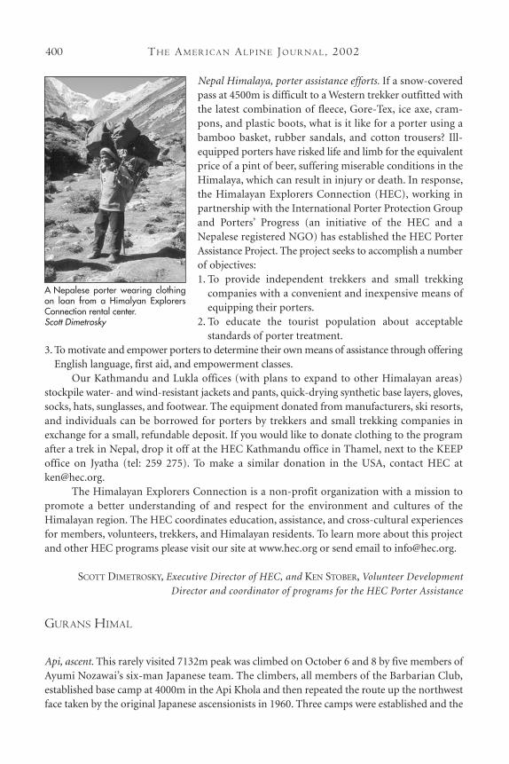
Nepal Himalaya, porter assistance efforts. If a snow-coveredpass at 4500m is difficult to a Western trekker outfitted withthe latest combination of fleece, Gore-Tex, ice axe, cram-pons, and plastic boots, what is it like for a porter using abamboo basket, rubber sandals, and cotton trousers? Ill-equipped porters have risked life and limb for the equivalentprice of a pint of beer, suffering miserable conditions in theHimalaya, which can result in injury or death. In response,the Himalayan Explorers Connection (HEC), working inpartnership with the International Porter Protection Groupand Porters’ Progress (an initiative of the HEC and aNepalese registered NGO) has established the HEC PorterAssistance Project. The project seeks to accomplish a numberof objectives:1. To provide independent trekkers and small trekking
companies with a convenient and inexpensive means ofequipping their porters.
2. To educate the tourist population about acceptable standards of porter treatment.
3. To motivate and empower porters to determine their own means of assistance through offeringEnglish language, first aid, and empowerment classes.
Our Kathmandu and Lukla offices (with plans to expand to other Himalayan areas)stockpile water- and wind-resistant jackets and pants, quick-drying synthetic base layers, gloves,socks, hats, sunglasses, and footwear. The equipment donated from manufacturers, ski resorts,and individuals can be borrowed for porters by trekkers and small trekking companies inexchange for a small, refundable deposit. If you would like to donate clothing to the programafter a trek in Nepal, drop it off at the HEC Kathmandu office in Thamel, next to the KEEPoffice on Jyatha (tel: 259 275). To make a similar donation in the USA, contact HEC [email protected].
The Himalayan Explorers Connection is a non-profit organization with a mission to promote a better understanding of and respect for the environment and cultures of theHimalayan region. The HEC coordinates education, assistance, and cross-cultural experiencesfor members, volunteers, trekkers, and Himalayan residents. To learn more about this projectand other HEC programs please visit our site at www.hec.org or send email to [email protected].
SCOTT DIMETROSKY, Executive Director of HEC, and KEN STOBER, Volunteer Development
Director and coordinator of programs for the HEC Porter Assistance
GURANS HIMAL
Api, ascent. This rarely visited 7132m peak was climbed on October 6 and 8 by five members ofAyumi Nozawai’s six-man Japanese team. The climbers, all members of the Barbarian Club,established base camp at 4000m in the Api Khola and then repeated the route up the northwestface taken by the original Japanese ascensionists in 1960. Three camps were established and the
A Nepalese porter wearing clothingon loan from a Himalyan ExplorersConnection rental center. Scott Dimetrosky
CL I M B S A N D EX P E D I T I O N S : NE PA L 401
summiteers were Hirotaka Imamura and Nozawai (on the 6th) and Tomoyuki Furuya, HiroshiIwazaki, and Fumihiro Ogiwara (on the 8th). This may be only the second or third ascent of theOriginal Route (the exact line followed by the successful Korean-Sherpa team in 1991 isunknown).
TAMOTSU NAKAMURA, Japanese Alpine News
Raksha Urai, attempt. Hubert Fritzenwaller’s five-man Austrian expedition failed at ca 5800mon one of Raksha Urai’s unclimbed summits (assumed to be the Rakshi Urai III as mentionedby the British party below). The team gave up on the east face in mid-May.
ELIZABETH HAWLEY
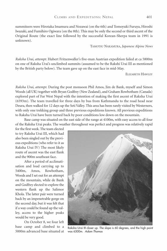
Raksha Urai, attempt. During the post monsoon Phil Amos, Jim de Bank, myself and SimonWoods (all UK) together with Bryan Godfrey (New Zealand), and Graham Rowbotham (Canada)explored part of Far West Nepal with the intention of making the first ascent of Raksha Urai(6593m). The team travelled for three days by bus from Kathmandu to the road head nearDeura, then walked for 12 days up the Seti Valley. This area has been rarely visited by Westerners,with only one trekking group and three previous expeditions known. All previous expeditionsto Raksha Urai have been turned back by poor conditions low down on the mountain.
Base camp was situated on the east side of the range at 4100m, with easy access to all fourof the Raksha Urai peaks. The weather throughout was perfect and progress was relatively rapidfor the first week. The team electedto try Raksha Urai III, which hadalso been singled out by the previ-ous expeditions (who refer to it asRaksha Urai IV) The most likelyroute of ascent was the east flankand the 900m southeast face.
After a period of acclimati-sation and load carrying up to5400m, Amos, Rowbotham,Woods and I set out for an attempton the mountain, while de Bankand Godfrey elected to explore thewestern flank up the SalimorKhola. The latter pair were turnedback by an impenetrable gorge onthe second day, but it was felt thatif a way could be found up the val-ley, access to the higher peakswould be very good.
On October 8, we four leftbase camp and climbed to a5000m advanced base situated at
Raksha Urai III closer up. The slope is 60 degrees, and the high pointwas 6500m. Adam Thomas
TH E AM E R I C A N AL P I N E JO U R NA L, 2002402
the start of the glacier. On the 9th we arrived at Camp 1, where we had previously cached loads.We spent the following day carrying and acclimatising up to a cache at 5800m. On the 11th weall climbed easy ground to a high camp at 5900m, situated on a large serac about 100m up thesoutheast face. We spent the rest of the day resting and acclimatising. However, a small stormthen delayed the summit attempt for a further day. Meanwhile de Bank and Godfrey hadreturned from their explorations and were coming up to join us, just one day behind.
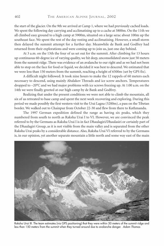
At 3 a.m. on the 13th the four of us set out for the summit. After climbing for 13 hoursup continuous 60-degree ice of varying quality, we hit deep, unconsolidated snow just 50 metersfrom the summit ridge. There was evidence of an avalanche to our right and as we had not beenable to stop on the face for food or liquid, we decided it was best to descend. We estimated thatwe were less than 150 meters from the summit, reaching a height of 6500m (set by GPS fix).
A difficult night followed. It took nine hours to make the 12 rappels of 60 meters eachnecessary to descend, using mainly Abalakov Threads and ice screw anchors. Temperaturesdropped to –20°C and we had major problems with ice screws freezing up. At 1:00 a.m. on the14th we were finally greeted at our high camp by de Bank and Godfrey.
Realizing that under the present conditions we were not able to climb the mountain, allsix of us retreated to base camp and spent the next week recovering and exploring. During thisperiod we made possibly the first western visit to the Urai Lagna (5200m), a pass on the Tibetanborder. We walked out to Chainpur from October 22-30 and flew from there to Kathmandu.
The 1997 German expedition defined the range as having six peaks, which they numbered from south to north as Raksha Urai I to VI. However, we are convinced the peakreferred to by the Germans as Raksha Urai I is in fact Dhaulagiri/Dhaulasiri or certainly part ofthe Dhaulagiri Group, as it is not visible from the main valley and is separated from the otherRaksha Urai peaks by a considerable distance. Also, Raksha Urai VI referred to by the Germansis, in our opinion, yet another separate mountain a little north and some way east of the main
Raksha Urai III. The team estimates (via GPS positioning) that they were within 50 meters of the summit ridge andless than 150 meters from the summit when they turned around due to avalanche danger. Adam Thomas
CL I M B S A N D EX P E D I T I O N S : NE PA L 403
range. We therefore suggest the most logical nomenclature for the Raksha Urai Group to befour peaks (I to IV) from south to north, so the Germans’ II now becomes I, etc. We also feelthat Raksha Urai III, which we attempted, is higher than the quoted 6593m for Raksha Urai andmore like 6650m.
All four peaks of Raksha Urai would make for superb high-standard alpinism in a beau-tiful and remote area. There are also other possibilities in the region, although any trip wouldnecessarily be a long and serious undertaking. More information can be obtained from myselfat [email protected] or from our website at www.virginsummits.org. The expeditionwon both the Helly Hansen Mountain Adventure and the Lyon Equipment awards in 2001.
ADAM THOMAS, United Kingdom
Dhaulagiri, ascents, attempts, and tragedies. On October 12 the Spanish climber, José Antonio‘Pepe’ Garces, the leader of a small Spanish-Italian expedition to the Normal Route up thenortheast ridge, was killed when he fell to his death from ca 8050m on the summit ridge. Hisbody could not be recovered. On the same day his fellow team member, Silvio Mondinelli,reached the summit. (Editor’s note: 44-year-old Garces was a prolific 8,000m collector and just a
few months previously had summited K2. Prior to this he had climbed Everest in 1991, Cho Oyu
in 1997, Gasherbrum I and II within one week during 1999, and Manaslu in 2000. He had also
reached the Central Summit of Shishapangma.)
On the much more difficult east face, which has only been climbed by nine people, threeJapanese disappeared sometime after October 14. The four-member team first went to the north-east ridge to acclimatise and Hideji Nazuka continued to the summit on his own, reaching thetop on the 11th. His fingers became frostbitten and he immediately left the mountain. Forty-six-year-old Nazuka has now climbed nine of the 8,000m peaks, with some of these achieved byoutstanding routes, such as the first winter ascent of the southwest face of Everest (1993; his sec-ond ascent of Everest), the first ascent of the northwest face of K2 (1990), and the northeast ridgeof Kangchenjunga (1991). The remaining three climbers, Masashi Fukumoto, Ryushi Hoshino,and Yukihiko Shinagawa, moved down to the base of the huge east face, which they hoped toclimb to an exit on to the northeast ridge at 7500m.
The trio were watched by another Japanese party led by Ryoji Yamada. This party was actual-ly part of the same expedition as Hoshino and friends but Yamada’s team had no intention ofattempting the east face. Team members saw the east face climbers start up early in the morning ofthe 12th with three days’ food. They later saw them make two bivouacs. Yamada himself watchedthem on the third day, the 14th, and reported that at 10:00 a.m. they had only reached 6400m or6500m.“They were moving very slowly, were very tired and not in good condition,” he observed. IfHoshino and team-mates had managed to reach the ridge at 7500m as planned, they would proba-bly have been alright, as Yamada had left a camp there for them, stocked with a good supply of food.
Yamada and his party departed base camp on the 16th, leaving only a cook. The lattercame back to Kathmandu alone on the 22nd or 23rd and told the trekking agent that theJapanese had not returned. He also added that on the 18th and 19th there had been very heavysnowfall with strong winds around the summit. Yamada was still in Kathmandu when the cookreturned and on the 24th he flew by helicopter to Dhaulagiri to search for the missing men.From the air Yamada could see no trace of the climbers nor any signs of avalanching on the face.He concluded that they must have fallen before they reached his ridge camp. Hoshino was 33

TH E AM E R I C A N AL P I N E JO U R NA L, 2002404
and one of the more renowned climbers from Japan with the southwest face of Everest, ChoOyu, Gasherbrum I and II, and the first ascent of Ultar to his credit.
A third Japanese expedition led by Kiyoshi Ishii was also on the mountain and climbedthe northeast ridge. Ishii reported in Kathmandu that two of his members and three Sherpashad reached the summit on October 2, the Sherpas saying that the point reached was the cor-rect summit. However, they, like other climbers before them, were wrong. They had actuallyreached a false summit. A German woman, Ms. Barbara Hirschbichler, went to the same pointat the same time. She said that she had seen a higher point to the west but at the time believedthe Japanese team’s Sherpas, who said no one went to the other (but true) summit. She there-fore did not try to climb it (if she had it would have meant retracing some of her ascent routeand then taking a different line, as it is very difficult to climb directly to the main top from thefalse summit). She was extremely disappointed to learn later that she had been given incorrectinformation.
ELIZABETH HAWLEY AND TAMOTSU NAKAMURA, Japanese Alpine News
Thapa, first official ascent. A French team led by Raphael Guilbert went to Thapa, the leastimportant of the nine new peaks opened by the Nepalese authorities in mid-May. This 6012mpeak lies just north of Dhaulagiri I and Tukuche, and is really no more than another bump ona mountain widely known as Dhampus. On October 28 the French made the first officiallyrecognised ascent by its western slopes. From their base camp at 5080m in the Hidden Valleysix summiteers took seven hours to make what they reported as an easy walk with a little snowat the top. When they returned to the Hidden Valley, they met several parties of trekkers whointended to climb Thapa. They also learned from their own Sherpas that it is not at all unusu-al for trekkers to climb it. The French felt they had been fooled into paying the Government aroyalty fee of $1,500 for a peak that others go to free of charge.
ELIZABETH HAWLEY
PERI HIMAL
Himlung Himal, second ascent, first ski descent. Our international expedition (French-Swedish-Algerian), which took place from April 15-June 10, comprised amateur climbers from theGrenoble-Oisans section of the French Alpine Club. The summit of Himlung Himal (7126m)had only been reached once before, by a team of Japanese climbers and Nepalese police officersin 1992. Since that time there have only been two other attempts: Germans in 1999 and Spanishin 2000. In common with all these expeditions, our route was also the northwest ridge.
On May 14 Béatrice Poupard, Kouid Beladem, Carole Soubiran, Sirdar Mulal Gurung,and I reached the summit. On May 19, Jean-Marie Gentzbittel, Ariane Chatelet, Eskil Eriksson,Fabrice Pintonato, and Olivier Soudieu also climbed to the top. Eriksson made the first skidescent from the summit.
The ascent of Himlung Himal turned out to be more complicated than we expected. Basecamp (4850m) was reached after a nine-day march from Besisahar, leaving the Annapurna Trekat Koto. From there the ascent to Camp I (5400m) could be made in tennis shoes during dryweather, but from Camp I to Camp II (6200m), the glacier was a labyrinth of crevasses and ser-
CL I M B S A N D EX P E D I T I O N S : NE PA L 405
acs. It was difficult to find the best way. About 150 meters of fixed rope was installed in orderto facilitate the negotiation of crevasses and 45-degree slopes. After Camp II, the route followeda long ridge for four or five hours toward the final pyramid. Despite the lack of technical diffi-culties, the length of this ridge made both the ascent and descent rather strenuous.
After an unsuccessful attempt to reach the summit from Camp II on May 10, CampIII was installed on the ridge about one hour from the start of the final pyramid. The last800 vertical meters never exceeded 30 degrees and offered no particular technical difficulties, though snow conditions were certainly not perfect (deep snow with some avalanche risk).
Camp II and III were totally dismantled by expedition members, and before leaving basecamp two or three porters were hired to bring some equipment down from Camp I. In additionto the mountaineering experience, the team had the pleasure of “discovering” the remote valleyof Nar and the village of Phu with its Tibetan culture.
PAUL CAMPION, French Alpine Club
MANASLU HIMAL
Manaslu, southeast face to east ridge, first ascent. A large Ukrainian expedition, marking the 10thanniversary of the country’s independence in 1991, had as its objectives a new route up thesoutheast face of Manaslu (8163m) and the first ascent of P2 (6251m a.k.a. Simnag Himal East)immediately south of Manaslu. The expedition, led by Valentyn Symonenko, comprised 15members, 10 of which were the most skilful climbers in the Ukraine.
Base camp was set up at 4000m and all the equipment transported there by helicopter.We began work on April 8, following the line of a relatively safe spur on the right side of theface to reach the upper east ridge (this spur lies to the right of the previous attempts by Poles,Kazakhs and Ukrainians in past years). From advanced base at 5000m to Camp 5 at 7300m ca4000m of rope was fixed. Intermediate camps, which were in snow caves, were established at5500m, 6000m, 6400m, and 6800m. The average angle of the spur was 55 degrees, but therewere more difficult sections of 60 degrees to 80 degrees, particularly between Camps 1 and 3and between Camps 4 and 5. These involved consistently tricky mixed climbing on rock thinlycovered with powder snow. Finally, Camp 6 was placed at ca 7500m near the top of the ridgeand a little distance below the Pinnacle or East Summit of Manaslu.
On May 19 the summit party climbed the ridge to 7650m but could not climb over thePinnacle or outflank it on the left due to the very steep terrain and a heavy covering of snow.The following day Vadym Leontyev, Sergiy Kovalov Sergiy Pugachov, and Vladyslav Terzyulclimbed around to the right of the Pinnacle and reached the summit plateau at ca 7500m.On May 21 these four stayed in their tents, as the weather was stormy with driving snow andno visibility. Kovalov, Leontyev, and Terzyul left the tent at 6:00 a.m. and reached the summitof Manaslu at 11 a.m. The ascent was made without oxygen and the route as a whole gradedRussian 6B. The same day all four climbers descended to 6300m and reached Samagon on the24th. They were flown back to Kathmandu by helicopter.
MSTYSLAV GORBENKO, Ukraine
TH E AM E R I C A N AL P I N E JO U R NA L, 2002406
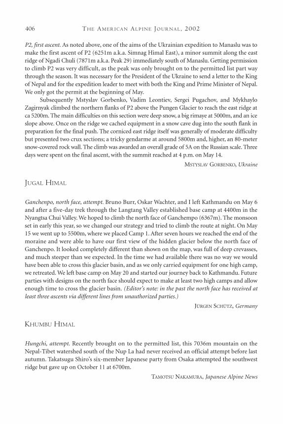
P2, first ascent. As noted above, one of the aims of the Ukrainian expedition to Manaslu was tomake the first ascent of P2 (6251m a.k.a. Simnag Himal East), a minor summit along the eastridge of Ngadi Chuli (7871m a.k.a. Peak 29) immediately south of Manaslu. Getting permissionto climb P2 was very difficult, as the peak was only brought on to the permitted list part waythrough the season. It was necessary for the President of the Ukraine to send a letter to the Kingof Nepal and for the expedition leader to meet with both the King and Prime Minister of Nepal.We only got the permit at the beginning of May.
Subsequently Mstyslav Gorbenko, Vadim Leontiev, Sergei Pugachov, and MykhayloZagirnyak climbed the northern flanks of P2 above the Pungen Glacier to reach the east ridge atca 5200m. The main difficulties on this section were deep snow, a big rimaye at 5000m, and an iceslope above. Once on the ridge we cached equipment in a snow cave dug into the south flank inpreparation for the final push. The corniced east ridge itself was generally of moderate difficultybut presented two crux sections; a tricky gendarme at around 5800m and, higher, an 80-metersnow-covered rock wall. The climb was awarded an overall grade of 5A on the Russian scale. Threedays were spent on the final ascent, with the summit reached at 4 p.m. on May 14.
MSTYSLAV GORBENKO, Ukraine
JUGAL HIMAL
Ganchenpo, north face, attempt. Bruno Burr, Oskar Wachter, and I left Kathmandu on May 6and after a five-day trek through the Langtang Valley established base camp at 4400m in theNyangtsa Chui Valley. We hoped to climb the north face of Ganchempo (6367m). The monsoonset in early this year, so we changed our strategy and tried to climb the route at night. On May15 we went up to 5500m, where we placed Camp 1. After seven hours we reached the end of themoraine and were able to have our first view of the hidden glacier below the north face ofGanchenpo. It looked completely different than shown on the map, was full of deep crevasses,and much steeper than we expected. In the time we had available there was no way we wouldhave been able to cross this glacier basin, and as we only carried equipment for one high camp,we retreated. We left base camp on May 20 and started our journey back to Kathmandu. Futureparties with designs on the north face should expect to make at least two high camps and allowenough time to cross the glacier basin. (Editor’s note: in the past the north face has received atleast three ascents via different lines from unauthorized parties.)
JÜRGEN SCHÜTZ, Germany
KHUMBU HIMAL
Hungchi, attempt. Recently brought on to the permitted list, this 7036m mountain on theNepal-Tibet watershed south of the Nup La had never received an official attempt before lastautumn. Takatsugu Shiro’s six-member Japanese party from Osaka attempted the southwestridge but gave up on October 11 at 6700m.
TAMOTSU NAKAMURA, Japanese Alpine News
CL I M B S A N D EX P E D I T I O N S : NE PA L 407
Kwangde Nup, north buttress direct ascent, Cheap Wine. During the post monsoon Czechclimbers, Jan Doudlebsky and Radek Lienerth, completed a new direct finish to the 1989American route on the North Buttress of Kwangde Nup (6035m). The pair began their climbon October 26 at ca 4800m, reaching the crest of the buttress from the right at 5150m. Theycompleted the route on the 30th, having climbed 37 pitches to the summit. Most of the lowersection was III to V+ but in the central section there was one pitch of VI-, two of VI, and oneof VII. After climbing the 60-degree snow/ice slope to below the steep headwall of the pillar,where they placed their fourth bivouac, they climbed three big pitches graded VIII/A2, VII+,and VIII-. Two pitches of ice (80 degrees, then 75 degrees) led to more rock, which was climbedin two more pitches of VII- to reach the summit slopes (50 degrees). The ca 1100m route waschristened Cheap Wine.
JIRI NOVAK, Czech Republic
Kwangde Lho, north face, second ascent of Breashears-Lowe route. After retreating from the right-handvariation on the northwest ridge of Ama Dablam (reported elsewhere), Alasdair Coull and Imade the second ascent of the 1982 Breashears-Lowe Route on the north or Hungo Face ofKwangde’s highest summit, Kwangde Lho (6187m). The line had been attempted three weekspreviously by British climbers, Dave Hollinger and Andy Sharpe, but they had been forced toretreat after 300 meters due to dangerous amounts of powder snow. We found it in much bettercondition, with all the loose snow having fallen off to leave good névé. As far as we could tell,conditions in the lower runnel were similar to those found on the first ascent; mainly goodnévé/ice with the seventh and eighth pitches being particularly thin. The average angle was 70-80 degrees.
After bivouacking at the bottom of the face, we managed to climb the whole ca 600-meter runnel on the first day. On the second day we continued to follow the original line,finding mainly straightforward steep snow. However, a couple of pitches were quite excitingdue to the sparse protection and unconsolidated nature of the snow. On reaching the middlerock band, we discovered the smear of ice, which provided the crux on the 1982 ascent, to benot properly formed. Instead, we traversed 100 meters to the right and bivouacked below a much fatter parallel band of névé. The following day we climbed through the 80-meter rock barrier at about Scottish IV, exiting on to the upper snowfield. The first half of the snow-field turned out to be perfect névé but the upper half was composed of very steep, unconsol-idated runnels.
We managed to find another bivouac site at the top of the snowfield (enough snow forreasonable bivouac ledges was found at all three sites) and in the morning climbed five morepitches of very deep powder to the ridge. We continued up the ridge for two more pitchesbefore contouring to the southwest ridge just below the summit. The route was 1400m highwith a crux section of Scottish VI, 5.
As for our descent, the upper rock was rappelled from in situ anchors for 180 meters toreach a snow ridge, which led easily down to a hanging glacier. We had another bivouac here,then spent the next two days descending the original route down to the Lumding Valley andover to the main Dudh Kosi at Ghat. The descent involved very complex route finding. A carefulstudy of Bill O’Connor’s Trekking Peaks of Nepal is highly recommended.
SAM CHINNERY, United Kingdom
TH E AM E R I C A N AL P I N E JO U R NA L, 2002408
Kwangde Shar, north face, second ascent to the summit, Extra Blue Sky. During the autumnBritish climbers Jon Bracey and Owen Samuel made the second ascent of Extra Blue Sky to thesummit of ca 6100m Kwangde Shar (fourth ascent to its junction with the north east ridge).This route on the north or Hungo Face of Kwangde Shar was climbed in November 1996 by theFrench, Samuel Beaugey, Christophe Profit, André Rhem, and Jérôme Ruby. Bracey, and Samuelmore or less followed the original line to where it begins to slant up left, then followed the routetaken in 2000 by British climbers Jules Cartwright and Sam Chinnery through the rock bandsand up steep snow to the crest of the northeast ridge. They made three bivouacs on the face andfound the climbing to be generally Scottish IV/V ice/mixed except for the crux pitch, a steepthin smear over compact rock (the same as that climbed by Cartwright and Chinnery), whichthey rated at Scottish VII, 6. On their fourth day they climbed the sustained upper section ofthe 1978 northeast ridge, surprised to find difficulties up to Scottish VI. After reaching the sharpsummit, a further two days were spent making the lengthy descent to the Lumding Valley andback over to the Dudh Kosi.
MOUNTAIN INFO, High Mountain Sports
Ama Dablam, northwest ridge, first ascent. A British expedition arrived below the mountain inOctober and based themselves in the flesh-pots of Pangboche with the aim of attempting theunclimbed northwest ridge of 6812m Ama Dablam. First off the mark were Sam Chinnery andAlasdair Coull, who set their sights of the right hand (southwest) spur descending from TsuroRi (a subsidiary summit on the northwest ridge). They approached this in one day (October27) from Pangboche via the normal Ama Dablam base camp and then northward up a screegully to an obvious notch at ca 4900m at the start of the main spur. After three days climbingup much disturbingly loose rock, following a line of abandoned fixed rope (thought to be froma previous Russian attempt), they came to a cache of equipment (snow stakes, etc). Theyclimbed two more pitches before deciding to abandon their attempt at ca 5900m due to thepoor quality and dangerous nature of the climbing. They rappelled their line of ascent and wentback to Pangboche, subsequently turning their attentions to Kwangde (reported elsewhere).
Also setting off on the 27th were Rich Cross and I. We wanted to try to climb directly upthe front face of the gable end of Tsuro Ri and continue up the northwest ridge. We camped onthe moraine of the Tsuro Glacier at ca 4900m and the next day set off early to climb the initial300-meter snow/névé slope (ca 50 degrees) that leads to the central weakness in the wall above.The stonefall on this slope was bad but by midday we were belaying at the start of the majorclimbing. Finding the wall to be steeper, looser, and offering little in the way of ledges, we decid-ed to retreat. There is a fantastic line up this face, but it would almost certainly require big walltactics (portaledge, haul bag, etc.).
After a short rest period at Pangboche, we decided to attempt the northwest spur of thegable end. Although this is longer, it looked to offer the least technical route to Tsuro Ri and weknew it had been tried many times in the past. We set off at 9:00 a.m. on November 1 with verylarge rucksacks. We first contoured to the shepherds huts at Ralha and then ascended to theTsuro Glacier. Crossing the dry glacier, we scrambled up to the lower part of the ridge and thenalong this for several hours, passing a large gendarme on the left, to arrive at a gravel col (ca4550m), where we made our first camp. Over the next four days we climbed the ridge to acampsite just below Tsuro Ri (ca 6100m). On this section all the gendarmes were either climbed
CL I M B S A N D EX P E D I T I O N S : NE PA L 409
direct or turned on the north flank, except at two points. The second of these, which occurredat ca 5800m on the last day, involved turning a vertical tower by 20 meters of down-climbingon a snow ramp to reach the upper gable end, then two long mixed pitches of Scottish 6 toregain the crest. Throughout the whole of this section we came across remarkably little in situgear; just 15 meters of old rope and only two fixed anchors.
The next two days were spent traversing the horizontal section of the ridge. Initially thiswas snow and ice, but later there were a large number of gendarmes that gave rock and mixedclimbing. It was necessary to make one rappel from a particularly large gendarme, which couldnot be turned. No fixed gear was found here. This section took us to the start of the upper face,which is defended by a very conspicuous serac barrier.
On the eighth day we made a three-pitch traverse rightward below the serac and thenclimbed back up to its flat plateau top via an ice pitch in a hidden couloir. The next day weclimbed good névé runnels, at first trending left, then back right, to join the north ridge about100 meters below the summit. Throughout this ascent we more or less followed the line of the1980 Japanese route, which is still festooned with ca 600+ meters of rope and over 30 rockanchors. We camped on the ridge at ca 6700m and the next day, November 10, reached thesummit at 9 a.m. In total, our route had involved around 4,000 meters of climbing in generally very settled but cold weather.
JULES CARTWRIGHT, United Kingdom
Pumori, west face, new route. A five-man expedition comprising four Swiss and one Americansplit into two groups with three of the team attempting the south ridge and the other two, Swissguides, Ueli Bühler and Ueli Steck, opting for the west face. After a suitable period of acclimati-sation Bühler and Steck crossed the rimaye at the bottom of the 1,400-meter face at 2 a.m. onMay 6. They adopted a very lightweight approach, taking one 60-meter rope and virtually nobivouac gear, thereby hoping to make a fast ascent. The pair reported that most of the face was55-60 degrees with some parts as steep as 80 degrees, while there was a section of mixed climb-ing at M4. They reached the south ridge at ca 6700m and continued to a bivouac at 6800m.Without gear Bühler and Steck were soon driven out of their bivouac by cold. Climbing again at2 a.m. on the 7th, they moved quickly up the remaining 350 meters until near disaster struck.While moving together up a 45-degree couloir, Steck set off a windslab avalanche that swept thetwo climbers back down the face. Fortunately, Bühler was able to stop them both and after get-ting over the shock they continued upward, reaching the summit at 6 a.m., just in time to see thesunrise. They then descended the east ridge. There were no fixed ropes in place as no one thatseason had climbed above the east col. Below the col, things became easier as they were able tofollow marker wands and use ropes placed by a German expedition. They were finally back intheir west face base camp (5200m) at 8:30 p.m., having spent 43 hours on the mountain.
ELIZABETH HAWLEY
Pumori, ascent, attempt, and tragedy. There were two events during the autumn on 7161mPumori that were noteworthy for entirely different reasons. The good news was the successfulascent by the first Iranian women mountaineers to come on any expedition to the NepaleseHimalaya. The team was led by Zerefeh Rahimzaddeh and comprised 11 members, eight of
TH E AM E R I C A N AL P I N E JO U R NA L, 2002410
whom were women. The three men were: an experienced Himalayan climber, Jalal ChesmehGhsabani, whom they wanted for his expertise; the team’s doctor, whom they needed as theyknew of no woman doctor who climbed; and a civil servant who never moved above base campand got extremely bored, but whom they had to take as their chaperon.
Three of the women successfully reached the summit on October 20 via the NormalRoute up the southeast face to the east ridge. The summiteers were Leila Bahrami, Mitra Nazari,and Farhondeh, together with Chesmah Ghsabani and three Sherpas. The Sherpas stopped try-ing to open the route at two quasi-vertical sections above the col on the east ridge because theythought the women would not be able to manage such difficulty. However, the women insist-ed, ropes were fixed, and the party of seven went to the top in a 10-hour summit day.
The Iranians had no accidents, but a team of 10 Basque mountaineers was not so lucky.These climbers were also on the Normal Route, but never summited. On October 19 five youngalpinists, Iñaki Aiertza (27), Javier Arkauz (22), Benat Arrue (22), Aritz Artieda (23), and CésarNieto (23), perished when seracs above them collapsed and the resulting avalanche carriedthem 600-800 meters down the face. This side of the mountain has a long history of avalanch-es that have resulted in fatal consequences and for this reason the Iranians never occupied acamp at the top of the southeast face, as the Basques and many other climbers before them haddone. The avalanche hit the Basques when they were just 50 meters above their camp, whichthey had pitched at ca 6200m.
ELIZABETH HAWLEY
Kangtega, east pillar, first ascent, winter ascent. The most interesting climb of the winter 2001-02 sea-son was a new line followed by a trio of Frenchmen on Kangtega, 6779m, a peak in the Everest regionsouthwest of Ama Dablam. Christophe Profit, Olivier Besson, and Andre Rhem made a rapid alpine-style climb of the east pillar to 6400m from a base camp at 5000m on the Hinku Nup Glacier.
Their pillar had never been attempted before, and for the first two days they encountered novery great difficulties. But above their second bivouac at 6,300m, after they had moved another 100meters to the shoulder, serious problems arose. The pillar ended at the shoulder, and now seracsthreatened from above. Straight up from the shoulder were not only dangerous seracs, but also a dif-ficult rock step with mixed rock and ice in some places. They decided to make an easy traverse to thenormal route on the southeast face, went to the top from there, and descended the face.
ELIZABETH HAWLEY
Editor’s note: Their original intention had been a direct line up the north face to the left of the oneclimbed by Valeri Babanov. However, conditions were too snowy, so they moved to the unclimbed pillarthat marks the left side of the face climbed by another French team in 1998 (AAJ 1999). The three firstacclimatized on the Normal Route up the Southeast Face, where they left a camp at 6000m to aid theirdescent. On the first two days they climbed some delicate mixed ground and steep rock steps with diffi-culties up to 5+/6a. On the third day they were unable to climb through the big serac barrier below thesummit slopes, as the ice was so hard their picks would not penetrate. Instead they made a dangerous tra-verse left beneath it to gain the southeast ridge. They descended to their pre-placed camp for the nightand on the following day climbed up for seven hours to the summit (December 5). It took them just sixhours to descend the Normal Route to their base camp.
CL I M B S A N D EX P E D I T I O N S : NE PA L 411
Everest, pre-monsoon statistics. The largest number of people in any single season reached thesummit of Everest during the spring. An astonishing total of 183 went to the top, 101 from thesouth and 82 from the north. The total far surpassed the previous record of 117 climbers in thespring of 1999. On just one day, May 23, 2001, 47 successfully reached the top via the normalNepalese route via the South Col, seven more than the previous record set in 1993 of 40 on May10. It is thought that 50 of the climbers reaching the top during the spring had already summitedin previous years, raising the grand total of individual summiteers to 1,114. Counting Sherpasand base camp staff it is estimated that the total number of people operating on the mountainthroughout the season was in excess of 1,000, and whereas in 2000 only two ascents were madewithout oxygen, in spring 2001 the number was nine. To get a more complete picture of thepopulation of the tent villages that sprang up, one must add uncounted dozens of trekkers, whowent to base camps and even advanced base camps.
ELIZABETH HAWLEY
Everest, oldest and youngest summiteers. The oldest person ever to reach the summit was a 64-year-old American physician, Sherman (“Sherm”) Bull. He was joined at the top by his son,Bradford (“Brad”) Bull (33). The pair were only the second father and son team to summit atthe same time. Sherman Bull, whose age surpasses by one year the previous oldest summiteer,Toshio Yamamoto, a Japanese climber aged 63 in May 2000, said this had been the fifth time hehad gone to Everest. When he finally made it all the way to the top, his success as the oldest sum-miteer didn’t really sink in immediately. However, getting to the top was “a dream come true.”
The youngest Everest summiteer was a 16-year-old Nepalese school boy, Temba TshiriSherpa, who had unsuccessfully tried to scale it from the Nepalese side in the spring of 2000and received severely frostbitten fingers, some of which had to be amputated. Now he was backagain, this time on the Tibetan side, as his own one-man team but with some help from otherson the mountain. Temba later reported he was a bit frightened by the three dead bodies heencountered in one area along the route. He also had difficulty doing things like putting on hisharness due to his damaged fingers. However, he had “a great feeling” when he got to the top.Now he plans to concentrate on his studies—he is in ninth grade—rather than to climb againsoon, but he could change his mind if someone were to give him “a good chance.”
ELIZABETH HAWLEY
Everest, the death of Babu Chiri. Babu Chiri, the incredibly strong and fast mountaineer whowas also the most famous Sherpa of recent times, died on April 29 at the age of 35. His mostspectacular feats on Everest include staying overnight on the summit without any bottled oxy-gen for 21 hours in May 1999, and then, after returning to base camp, making another completeascent later in the same month. The following year he achieved the fastest ever ascent madefrom base camp to summit on the Nepalese side, when he climbed to the top in just 16 hoursand 56 minutes. In May 1995 he became the first person ever to make two ascents of the moun-tain in the same month. He made 10 ascents of Everest, and if he had been successful in thespring, his total of 11 would have been equalled by only one person, Appa Sherpa.
TH E AM E R I C A N AL P I N E JO U R NA L, 2002412
Babu Chiri was a fine person, a “gentleman” as one frequent American Everest summi-teer used to call him. He wanted to build a school for the children of his home village, Taksindu,which has none. His next climbing project was to attempt an incredible traverse of Everest fromthe Tibetan base camp to the Khumbu base camp, then immediately turn around and reversethe traverse. This was a plan only Babu Chiri would contemplate.
However, this dream died with him when he fell into a crevasse near Camp 2 in theWestern Cwm. At around 4 p.m. on April 29 he told others he was going to take some photo-graphs in the vicinity of the camp. When he hadn’t returned by 9 p.m., his brother Dawa wentout to search for him. Another expedition leader, Willi Benegas, and his head Sherpa, PembaGyalzen, joined the search and around midnight found Babu’s footprints leading to a crevasse.Due to fresh snow, the crevasse was not readily visible and was only apparent because of theobvious hole caused by someone falling in. While two Sherpas belayed him, Benegas descend-ed around 10 meters into the crevasse, found the body and ascertained Babu was dead. At 6 thefollowing morning the effort to recover the body began and it was brought to the surface threehours later. His death was reported in the media around the world and tributes poured in. KingBirendra of Nepal sent a message of condolence to the family. In this statement he declared thatBabu’s “demise has caused irreparable loss to the nation and to the mountaineering fraternity.”The prime minister and other dignitaries paid their respects at the Sherpa Centre inKathmandu, where Babu’s body, covered with flowers and Buddhist ceremonial scarves, hadbeen brought.
ELIZABETH HAWLEY
Everest, first ascent by a blind person. The most remarkable of all the summiteers in the springwas the 32-year-old totally sightless American climber, Erik Weihenmayer. On his return toKathmandu he said “I spent two and a half months getting there from my arrival at base camp.You work so hard and so long to get there but I just took it day by day. And when I took the laststep to the top, it was almost an anticlimax.” Weihenmayer was among the 26 successful menand women who reached the summit on May 25, the last day of the season on which anyonereached the top.
A major problem during his climb was the notorious network of crevasses in theKhumbu Icefall. He said it took him a long time to get accustomed to jumping them. He man-aged to cope because he received guidance from a team-mate who placed Weihenmayer’s footat one edge. Then, in order to judge the distance he had to jump, Weihenmayer probed theother lip with ski poles. Once, he came to a crevasse unexpectedly and in his surprise put a legdown it. His torso landed safely on the far side and he sustained no injury.
A retinal disease made Weihenmayer sightless when he was 13. Before attempting Everesthe had considerable climbing experience, which included Aconcagua, McKinley, and El Capitan.Before going into the Everest region, he said in Kathmandu that he was “confident about howI perform in the mountains. The reason I do it is probably the same as that of anyone else. Iprobably have to put in more effort but for me it is still the same adventure and excitement. Iget a lot of pleasure out of the wind and sun on my face and the feeling of rock under my feet;the same kind of pleasure that others get out of the view.”
However, there were other climbers on Everest who expected a disaster. One of them callously remarked that he planned to stay near Weihenmayer so that he would be “the first to
CL I M B S A N D EX P E D I T I O N S : NE PA L 413
take a picture of the dead blind guy.” However, there was no picture to be taken. Guided by abell on the rucksack of a team-mate ahead of him and by his own feeling and probing,Weihenmayer, with three team-mates and at least one Sherpa, arrived at the top of the Worldat 10:05 a.m. on May 25 and descended safely over the next few days.
ELIZABETH HAWLEY
Everest, post monsoon attempts. In stark contrast to the unprecedented hordes of climbers onEverest during the spring, the post monsoon season saw practically no one on the mountain.For the first time since autumn 1970 not a single team came to the Nepalese side of the peakand in Tibet there were only three (see elsewhere).
ELIZABETH HAWLEY
For more on Everest from the north side, see the Tibet reports.
Lhotse Middle, first ascent. The most impressive all of accomplishments in the spring was the firstascent of Lhotse Middle (8413m), which although not exactly a mountain in its own right,stands only 50 meters lower than Makalu and was widely recognised to be the highest unclimbedsummit in the world. Various expeditions in recent years had planned to reach it from the westvia the main summit of Lhotse, or from the east via Lhotse Shar. Some had tried the south faceof the Lhotse-Lhotse Shar ridge. Most of these teams had come from the former Soviet Unionbut all had failed to make a serious attempt from east or west above the two summits.
In the spring 12 Russian climbers led by Sergei Timofeev took an entirely different approach.First they ascended the Normal Route on Everest as far as the South Col, then they moved alongLhotse’s unclimbed north ridge and out on to the previously untouched north or Kangshung face,which is technically in Tibet. Finally, they climbed up to the middle summit’s west ridge.
The Nepalese Government had not officially brought Lhotse Shar on to the permitted listwhen the Russians established Base Camp at the standard Everest site on April 1. As with sev-eral previous expeditions attempting the Middle Summit, they were operating under a permitfor Lhotse Main and with the help of another expedition comprising just two men, SimoneMoro and Denis Urubko, who planned to attempt an Everest-Lhotse traverse (see elsewhere),began to equip the Normal Everest route up to the South Col. By the end of the month they hadthe route opened and much of the necessary equipment up at Camp 4 on the Col, but still nopermit from the Nepalese Government. However, on May 16, two weeks before the proposedend of the expedition, the vice-secretary of the Ministry of Tourism visited Everest Base Campto hand over personally to the Russians the long awaited permission.
Over the next days Alexey Bolotov, Petr Kuznetsov, Evgeny Vinogradsky, and Timofeevpushed the route across the upper Kangshung Face, fixing more than 1000 meters of rope. Onthe 22nd they eventually gained the foot of the rock wall below the ridge. The steepness of someof the climbing here was estimated to be at least 65 degrees. Finally, on the 23rd, the Russiansclimbed a difficult leftward-slanting snow ramp leading to the lower part of the ridge thatdescends east from Lhotse’s Main Summit. They climbed down this ridge to the lowest pointand then up the final 70 meters or so of very steep and narrow crest towards the top of LhotseMiddle. The four arrived a little below the top at 3:00 p.m. but felt the snow conditions on the
TH E AM E R I C A N AL P I N E JO U R NA L, 2002414
summit cornice were a little too dangerous to climb to the highest point. The final rock step justbelow the top was a “very difficult 90-degree wall,” well led by Bolotov and graded VI.
On the 24th Nikolai Jiline, Yuri Koshelenko, and Gleb Sokolov repeated the ascent, and thefollowing day it was the turn of Vladimir Ianotchkine and Victor Volodin. All summiteers used supplementary oxygen and all except Koshelenko had been to the top of an 8000m peak before. Inthis respect Vinogradski was the most experienced high altitude climber. He has summited Everestfour times, Cho Oyu twice, Lhotse, Lhotse Shar, and was part of the Kangchenjunga traverse expe-dition. The full story of theis rescue appears earlier in this journal.
ELIZABETH HAWLEY AND YURI KOSHELENKO, Russia
Lhotse, rescue. A rather dramatic rescue of a British climber took place on Lhotse’s normal westface route. The Briton was 19-year-old Thomas Moores, who was part of an American-led commercially organized expedition. He had reached the summit on May 21 with a Polishclimber, Dariusz Zaluski, who was on a different permit. On the descent, close to the base of thecouloir, Zaluski saw Moores fall ca 150 meters from an altitude of 8300m
The principal rescuer was Simone Moro, an Italian with another Lhotse permit, who wasin his tent at 7950m making preparations for his own summit bid during the next day or so(Moro with the Kazakhstan mountaineer, Denis Urubko, had a permit to link the summits ofEverest and Lhotse via the unclimbed north ridge of Lhotse, a much talked about Himalayanobjective). At 6 p.m. he heard Zaluski shout about Moores’s fall. Later, back in Kathmadu, Mororeported that when he heard Zaluski, he immediately left his tent to rescue the fallen Briton. Hesaid no one in any of the other tents at that camp on Lhotse’s west face would join him becausethey said they would loose their chance at reaching the top. So Moro went up alone. He foundMoores at 7 p.m., lying on his back in deep snow, which Moro feared could avalanche at anytime. Moores’s face was bleeding and he had lost a crampon but had been given more oxygenby Zaluski.
Moro, who has considerable experience on Nepal’s great Himalayan peaks, is reported tohave hoisted the teenager (who weighed no more than 50 kg) on to his back, though otherreports suggest he attached him to his own ice axe, then kicked big steps in the snow to helpMoores reach Camp 4, which was situated left of a rock formation on the west face of Lhotseknown as The Turtle. Back at Moro’s tent, the Italian provided water and first aid, then the fol-lowing morning organized more oxygen and arranged for a couple of Sherpas from a differentexpedition to escort Moores down towards the Western Cwm. That day an exhausted Mororealised that he had sacrificed his own summit bid.
Moores was the only member of his expedition to make a summit attempt. The leader,the American, Gary Pfisterer, said later in Kathmandu that he had instructed Moores to spendonly one night at the high camp (which had been left behind by a Korean group when they leftthe mountain) and then to descend. However, the young Briton stayed on for another day andsummited without the use of supplementary oxygen. He was later evacuated by helicopter to Kathmandu, where he was found to have internal injuries and was sent on to hospital in Bangkok.
ELIZABETH HAWLEY

CL I M B S A N D EX P E D I T I O N S : NE PA L 415
The huge south face of Lhotse, attempted in winter by a Japanese party. For route information, see the photographon the following page. Photo courtesy of Chunichi Shimbum Ltd.
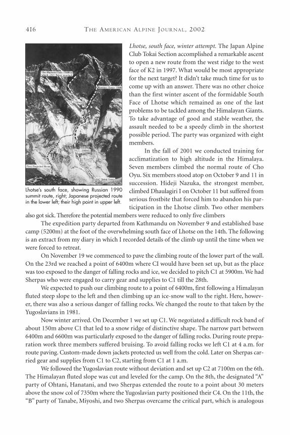
TH E AM E R I C A N AL P I N E JO U R NA L, 2002416
Lhotse, south face, winter attempt. The Japan AlpineClub Tokai Section accomplished a remarkable ascentto open a new route from the west ridge to the westface of K2 in 1997. What would be most appropriatefor the next target? It didn’t take much time for us tocome up with an answer. There was no other choicethan the first winter ascent of the formidable SouthFace of Lhotse which remained as one of the lastproblems to be tackled among the Himalayan Giants.To take advantage of good and stable weather, theassault needed to be a speedy climb in the shortestpossible period. The party was organized with eightmembers.
In the fall of 2001 we conducted training foracclimatization to high altitude in the Himalaya.Seven members climbed the normal route of ChoOyu. Six members stood atop on October 9 and 11 insuccession. Hideji Nazuka, the strongest member,climbed Dhaulagiri I on October 11 but suffered fromserious frostbite that forced him to abandon his par-ticipation in the Lhotse climb. Two other members
also got sick. Therefore the potential members were reduced to only five climbersThe expedition party departed from Kathmandu on November 9 and established base
camp (5200m) at the foot of the overwhelming south face of Lhotse on the 14th. The followingis an extract from my diary in which I recorded details of the climb up until the time when wewere forced to retreat.
On November 19 we commenced to pave the climbing route of the lower part of the wall.On the 23rd we reached a point of 6400m where CI would have been set up, but as the placewas too exposed to the danger of falling rocks and ice, we decided to pitch C1 at 5900m. We hadSherpas who were engaged to carry gear and supplies to C1 till the 28th.
We expected to push our climbing route to a point of 6400m, first following a Himalayanfluted steep slope to the left and then climbing up an ice-snow wall to the right. Here, howev-er, there was also a serious danger of falling rocks. We changed the route to that taken by theYugoslavians in 1981.
Now winter arrived. On December 1 we set up C1. We negotiated a difficult rock band ofabout 150m above C1 that led to a snow ridge of distinctive shape. The narrow part between6400m and 6600m was particularly exposed to the danger of falling rocks. During route prepa-ration work three members suffered bruising. To avoid falling rocks we left C1 at 4 a.m. forroute paving. Custom-made down jackets protected us well from the cold. Later on Sherpas car-ried gear and supplies from C1 to C2, starting from C1 at 1 a.m.
We followed the Yugoslavian route without deviation and set up C2 at 7100m on the 6th.The Himalayan fluted slope was cut and leveled for the camp. On the 8th, the designated “A”party of Ohtani, Hanatani, and two Sherpas extended the route to a point about 30 metersabove the snow col of 7350m where the Yugoslavian party positioned their C4. On the 11th, the“B” party of Tanabe, Miyoshi, and two Sherpas overcame the critical part, which is analogous
Lhotse’s south face, showing Russian 1990summit route, right; Japanese projected routein the lower left; their high point in upper left.
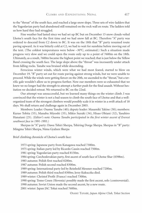
CL I M B S A N D EX P E D I T I O N S : NE PA L 417
to the “throat” of the south face, and reached a large snow slope. Three sets of wire-ladders thatthe Yugoslavian party had abandoned still remained on the rock wall en route. The ladders toldus how hard they had struggled.
Fine weather had lasted since we had set up BC but on December 15 snow clouds veiledLhotse’s south face for the first time and we had snow fall at BC. Therefore “A” party wasordered to descend from C2 down to BC. It was on the 18th that “B” party resumed routepaving upward. As it was bitterly cold at C2, we had to wait for sunshine before moving out ofthe tent. (The coldest temperatures were below –30°C, estimated.) Such a situation madeprogress very slow and we could open the route only up to a point of 7600m on the 18th.Ultimately, as a result, 7600m became the highest point we reached; that is just below the YellowBand crossing the south face. The large slope above the “throat” was incessantly under attackfrom falling rocks. Tanabe was bruised while descending.
Ferocious winter winds, which were what we had most feared, started to blow onDecember 19. “B” party set out for route paving against strong winds, but we were unable toproceed. While the winds were getting fiercer on the 20th, we ascended to the “throat,” but a ter-rific gale wouldn’t allow us to progress further. Now our members were so exhausted that weknew we no longer had the strength to attempt a further push for the final assault. Without hes-itation we decided retreat. We returned to BC on the 22nd.
Our attempt was unsuccessful, but we learned many things on the winter climb. I wasconvinced that the winter is not a bad season to climb the south face of Lhotse and that a well-organized team of the strongest climbers would possibly scale it in winter in a swift attack of 18days. We shall return and challenge again in December 2003.
Members: Leader: Osamu Tanabe (40); deputy leader: Masamiki Takine (50); members:Kazuo Tobita (55), Manabu Miyoshi (35), Mikio Suzuki (34), Hisao Ohtani (32), YasuhiroHanatani (25). (Editor’s note: Osamu Tanabe participated in the first winter ascent of Everestsouthwest face in 1991-1993.)
Sherpas in “A” party: Dawa Tshiri Sherpa, Tshiring Dorge Sherpa. Sherpas in “B” party:Mingma Tshiri Sherpa, Nima Gyalzen Sherpa
Brief climbing chronicle of Lhotse’s south face:
1973 spring: Japanese party from Kanagawa reached 7300m.1975 spring: Italian party led by Ricardo Cassin reached 7500m.1981 spring: Yugoslavian party reached 8150m.1984 spring: Czechoslovakian party, first ascent of south face of Lhotse Shar (8398m).1985 autumn: Polish first reached 8200m.1987 autumn: Polish second reached 8300m.1989 spring: International party led by Reinhold Messner reached 7200m.1989 autumn: Polish third reached 8300m; Jerzy Kukuczka died.1989 winter: Christof Profit (France) reached 7300m.1990 spring: Tomo Cesen (Slovenia) possibly made the first ascent, solo (controversial).1990 autumn: Soviet Union made the second ascent, by a new route.2001 winter: Japan JAC Tokai reached 7600m.
OSAMU TANABE, Japan Alpine Club, Tokai Section