Embed Size (px)
Citation preview

3D GRAVITY EFFECTS OF THE SEDIMENTARY COMPLEXES IN
THE CARPATHIAN�PANNONIAN REGION
I. MAKARENKO1, O. LEGOSTAEVA1, M. BIELIK2, V. STAROSTENKO1, J. DÉREROVÁ2
and J. �EFARA3
1 Institute of the Geophysics, National Academy of Sciences, Kiev, Ukraine 2 Geophysical Institute, Slovak Academy of Sciences, Bratislava, Slovakia
3 Faculty of Natural Sciences, Commenius University, Bratislava, Slovakia
Abstract: The purpose of this paper is to demonstrate the gravity effects of the sediments of the outer
Carpathians, the Pannonian basin and Transylvanian basin. An exclusive approach to 3D gravity
modelling has been used to determination of gravity effect of sedimentary filling in the Pannonian
basin and Transylvanian basin, outer (flysch) Carpathians and molasse foredeep of outer Carpathians.
The gravity effect of the foredeep sediments varies from 0 to �55 mGal. The largest effect of the flysch
sediments of the outer Carpathians can be observed in the Western and Eastern Carpathians junction
(up to -45 mGal) and in the Eastern and Southern Carpathians junction (up to �25 mGal). The gravity
effect of the sediments in the Pannonian (Transylvanian) basin varies from 0 to �50 (-40) mGal. The
Danube basin, Békés basin and Makó basin are characterized approximately by the same values (-
50mGal). Maximum gravity effect of the Transcarpathian basin and the northern basins in the Great
Hungarian basin is about �45mGal. Sáva graben and Drava graben reach maximum of gravity effect
about of �40 mGal.
Key words: 3D gravity modelling, sediments, Carpathian-Pannonian region
Introduction
One of the most typical feature of the Carpathian-Pannonian basin results from its evolution is a
large thickness of sediment both in the foredeep (outer Carpathians) and in the foreland of the
Carpathian orogen (in the inner-Carpathians, Pannonian basin and Transylvanian basin), as well. The
outer Carpathians comprise molassic sediments of the Late Tertiary Carpathian foredeep deposited on
the southern flanks of the European Platform and the broad Flysch belt that is composed of numerous
thrust units (Pla�ienka et al. 1998). The Flysch belt represents two groups: a) the Silesian-Moldavian

(Krosno-menilite) nappes in the north, and b) the Magura thrust system in the south. Thick flysch
sediments of the Jurassic to early Miocene age were scraped off a strongly attenuated continental, in
some parts also probably oceanic crust (Pla�ienka et al. 1998).
The purpose of this paper is to demonstrate the gravity effects of the sediments of the outer
Carpathians, the Pannonian basin and Transylvanian basin. These 3D gravity effects of the sediments
will used for calculation of the stripped gravity map of the Carpathian-Pannonian-Transylvanian�s
region (Fig.1) in order to obtain the gravity anomalies which will demonstrate deep-seated anomalous
bodies within lithosphere.
An exclusive approach to 3D gravity modelling has been used to determination of gravity effect of
sedimentary filling in the Pannonian basin and Transylvanian basin, outer (flysch) Carpathians and
molasse foredeep of outer Carpathians. The gravity
Fig. 1
effects of the mentioned sedimentary layers have been calculated using complex of programs which
enables to solve a direct 3D gravity problem within an arbitrarily dense network (grid) from media with
a complicated relief of the discontinuities and an arbitrary density distribution in each layer
(Starostenko and Legostaeva 1998, Legostaeva 2000). It is especially effective in studying sedimentary
basins (Buryanov et al. 2001 ).

3D density model of the sedimentary filling
3D density model consists of three different tectonic sedimentary complexes: the Pannonian basin
and Transylvanian basin, the outer Carpathian foredeep sediments and the outer Flysch Carpathians
sediments.
The thickness of the Neogene-Quaternally sediments in the intra-Carpathian region (in the
Pannonian basin and Transylvanian basin was compiled by the results published by Bielik (1988),
Kilényi and �efara (1989), Szafián et al. (1997). The resultant map of the thickness of the sediments is
illustrated in the Fig. 2. The thickness of the sedimentary basin varies between 0 to 9 km, with average
of 2.5 -3.0 km. The filling of the basin mainly consists of sands, clays, shales, sandstones with isolated
limestones and evaporites, and also clays and marls in the layers closest to the surface. For estimation
of the density model sedimentary basin we used the data from Bielik (1988), �efara et al. (1987),
Szafián et al. (1997), Grasser (1988), Bucha et al. (1994), �efara and Szabó (1997). Mean density
contrasts for the depth intervals are shown in the Table 1.
Depths km
Grasser (1987)
Bielik (1988)
Szafian et al. (1997)
Bucha et al. (1988)
�efara-Szabó (1997)
Average values
0-1 2,330 2,125 2,000 2,150 2,105 2,142 1-2 2,465 2,310 2,200 2,275 2,320 2,314 2-3 2,560 2,440 2,365 2,450 2,470 2,457 3-4 2,610 2,580 2,415 2,550 2,520 2,535 4-5 - 2,660 2,480 2,620 2,570 2,580 5-6 - - - - - 2,625 6-7 - - - - - 2,670
Tab. 1
The map thickness of the outer Carpathian foredeep sediments was compiled by using data
published by Kováč (2000). The thickness of the molassic sediments of the Late Tertiary Carpathian
foredeep (Fig. 2) is the smallest in the outer Western Carpathians (0 - 2 km), then increase in the outer
Eastern Carpathians (0 - 4 km) and the largest in the outer Eastern and Southern Carpathians junction
(up to 9 km). In the Southern Carpathians it is less then 4 km. Density distributions were taken from
Królikowski and Petecki (2001), of whom data were derived from the well-logging (85%) and
laboratory tests on drilling cores. The average density of the foredeep sediments in the western
(eastern) part of Poland is 2.62 gcm-3 (2.42 gcm-3). The density pattern is relatively complicated,
however, and for the actual computations a simple, but best-fit density pattern had to be adopted. For

our preliminary 3D gravity modelling we adopted Krolikowski and Petecki�s results for the whole
outer Carpathian foredeep.
The model of the outer Flysch Carpathians sediments (Fig. 2) were compiled by using data from
Krejčí (1997), Rylko (not published data), Mocanu and Radulescu (1994), Matenco (1997), Kováč
(2000). Note that the we have only a few available data relate to the thickness of the flysch sediment.
Especially, it is in the region where it is supposed the deepest thickness (10-15 km) of these sediments.
It is well-known (Tomek 1979, Królikowski and Petecki 2001) that density of the flysch sediments
varies extremely fast both vertically and horizontally as well as. In spite of that we unified densities for
our calculations based on the results of Królikowski and Petecki (2001).
Gravity effect of sedimentary layers
The gravity effect of the sedimentary layers (Fig. 2) have been calculated using a complex of
program, in which the original data (model of the thickness and density of the sedimentary fillings)
were introduced in the form of maps and transformed into vector (Starostenko et a. 1997). For 3D
gravity modelling was used the method, which was developed by Starostenko et a. (1998). Calculation
have been made at the scale of 1 : 4 000 000 on the grid of 4x4 (10x10) km. Therefore the model field
reflects all the features of the medium.
The gravity effect of the foredeep sediments varies from 0 to �55 mGal. The largest effect of �55
mGal can be observed in the Eastern and Southern Carpathians junction. In the Eastern Carpathians
maximum gravity effect is of about-20 mGal, in the Southern Carpathians attends up to �30 mGal, in
the Western and Eastern Carpathians junction it is of �15 mGal and the smallest it is in the Bohemian
Massif and the Western Carpathians junction.
The largest effect of the flysch sediments of the outer Carpathians can be observed in the Western
and Eastern Carpathians junction (up to -45 mGal) and in the Eastern and Southern Carpathians
junction (up to �25 mGal).
The gravity effect of the sediments in the Pannonian (Transylvanian) basin varies from 0 to �50 (-
40) mGal. The Danube basin, Békés basin and Makó basin are characterized approximately by the
same values (-50 mGal). Maximum gravity effect of the Transcarpathian basin and the northern basins
in the Great Hungarian basin is about �45mGal. Sáva graben and Drava graben reach maximum of
gravity effect about of �40 mGal.
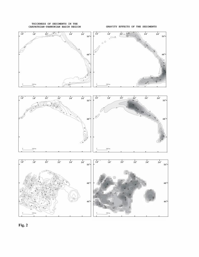
Fig. 2

References Bielik, M., l988: A preliminary stripped gravity map of the Pannonian basin. Physics of the Earth and Planetary Interiors,
51, 185-189. Bucha, V., Blí�kovský, M., Burda, M., Krs, M., Suk, M., �efara, J., et al. 1994: Crustal structure of the Bohemian Massif
and the West carpathians. Praha-heidelberg, 355. Buryanov V.B., Makarenko I.B., Starostenko V.I., Legostaeva O.V., Garetsky R.G., Dankevich I.V., and Karataev G.I.,
2001: The Pripyat Trough: gravity effect of sediments and basement density inhomogeneities. Geophysical Journal, 20, 679-69.
Granser, H., 1987: Three-dimensional interpretation of gravity data from sedimentary basins using an exponential density-depth function. Geophysical Prospecting, 35, 1030-1041.
Kilényi, E. and �efara, J., (Eds), 1989: Pre-Tertiary basement countour map of the Carpathian Basin beneath Austria, Czechoslovakia and Hungary. ELGI, Budapest.
Kováč, M., 2000: Geodynamický, paleografický a �truktúrny vývoj karpatsko-panónskeho regiónu v miocéne. Veda Bratislava, 202.
Krejčí, O., Jurová, Z., 1997: Struktúrní mapa báze sedimentu fly�ových příkrovu s vyznačením prognóznich ploch. Manuskript ČGÚ Brno.
Królikovski, C., Petecki, Z., 2001: Recent results of the gravity and magnetotelluric modelling: lithosphere structure in the Polish Carpathians. Slovak Geol. Mag., 7, 131-138
Legostaeva, O. 2000: On optimal scheme of computing double integrals in solving direct gravimetric and magnetometric problems. Geophysical Journal, 19, 693-699.
Matenco, L.C., 1997: Tectonic evolution of the outer Romanian carpathians: Constrain from kinematic analysis and flexural modelling. Vrije Universiteit, Amsterdam, 160.
Mocanu, V. and Radulescu, F., 1994: Geophysical features of the Romanian territory. In: Berza, T. (Ed.), ALCAPA II, Geological evolution of the Alpine-Carpathian-Pannonian systém. Romanian Journal of Tectonics and Regional Geology, 75, 17-36.
Pla�ienka, D., Grecula, P., Puti�, M., Hovorka, D. and Kováč, M., 1998: Evolution and structure of the Western Carpathians: an overview. In: Grecula, P., Hovorka, D. and Puti�, M. (Eds), Geological evolution of the Western Carpathians. Miner. Slovaca Corporation-Geocomplex, a.s., Geofyzika Bratislava and Geological Survey of Slovak Republic, Bratislava. 35-42.
Rylko W. & Tomas A., 1995: Map of pre-Tertiary basement of the outer Western Carpathians in Poland. Unpublished manuscript.
Rylko W. & Tomas A., 1995: Map of pre-Tertiary basement of the outer Western Carpathians in Poland. Unpublished manuscript.
Starostenko, V.I., Legostaeva, O.V., 1998: Calculation of the gravity field from an inhomogeneous, arbitrarily truncated vertical rectangular prism. Izvestiya, Physics of the Solid Earth, 34, 991-1003.
Starostenko, V.I., Matsello, V.V., Aksak, I.N., Kulesh, V.A., Legostaeva, O.V., Yegorova, T.P., 1997: Automation of the computer input of images of geophysical maps and their digital modelling. GeophysicalJournal, 17,1-19.
Szafián, P., Horváth, F. and Cloetingh, S., 1997: Gravity constrains on the crustal structure and slab evolution along a trans-Carpathian transect. Tectonophysics, 272, 233-247.
�efara, J., Szabó 1997: Gravity maps � border zone of Austria, Slovakia and Hungary. Geophysical Transactions ELGI, 41, 101-122.
�efara, J., Bielik, M., Bodnár, J., Čí�ek, P., Filo, M., Gnojek, I., Grecula, P., Halme�ová, S., Husák, Ľ., Jano�tík, B., Král, M., Kube�, P., Kucharič, Ľ., Kurkin, M., Le�ko, B., Miku�ka, J., Mu�ka, P., Obernauer, D., Pospí�il, L., Puti�, M., �utora, A. and Velich, R., l987: �truktúrno--tektonická mapa vnútorných Západných Karpát pre účely prognózovania lo�ísk - geofyzikálne interpretácie. SGÚ Bratislava - Geofyzika, n.p. Brno - Uran. priemysel Liberec, 267.
Tomek, Č., �vancara, J. and Budík, L., 1979: The depth and the origin of the West Carpathian gravity low. Earth Planet. Sci. Lett., 44, 39-42.