Embed Size (px)
Citation preview
3. Environmental Setting, Impacts and Mitigation Measures
Occidental College Specific Plan 3J-1 ESA / D205278 Draft EIR September 2008
3J. Transportation, Circulation and Parking This section presents the methodology, findings, and conclusions of the traffic impact analysis prepared by Fehr & Peers/Kaku Associates to evaluate the potential traffic and circulation impacts of the proposed project.1 The primary purpose of this analysis is to review existing traffic conditions in the vicinity of the project site and analyze the impacts associated with 1) the proposed project, including parking; and 2) cumulative developments in the City of Los Angeles and surrounding area. A copy of the full traffic study is in Appendix F of this EIR.
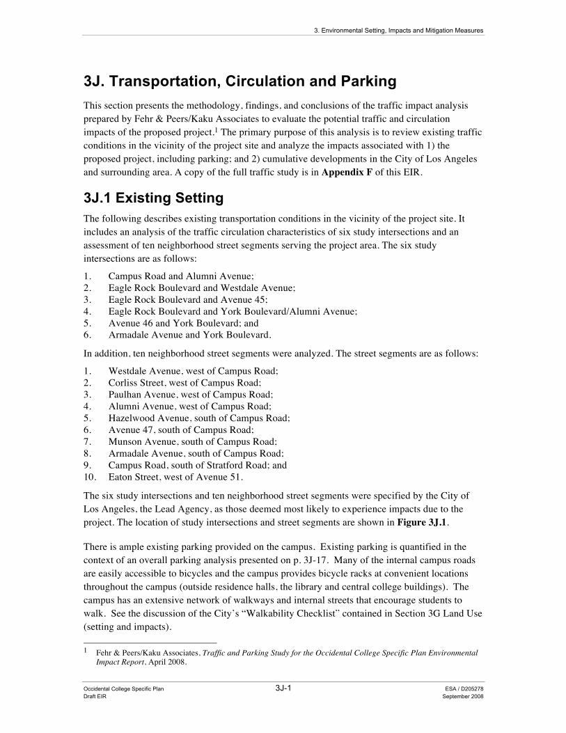
3J.1 Existing Setting The following describes existing transportation conditions in the vicinity of the project site. It includes an analysis of the traffic circulation characteristics of six study intersections and an assessment of ten neighborhood street segments serving the project area. The six study intersections are as follows:
1. Campus Road and Alumni Avenue; 2. Eagle Rock Boulevard and Westdale Avenue; 3. Eagle Rock Boulevard and Avenue 45; 4. Eagle Rock Boulevard and York Boulevard/Alumni Avenue; 5. Avenue 46 and York Boulevard; and 6. Armadale Avenue and York Boulevard.
In addition, ten neighborhood street segments were analyzed. The street segments are as follows:
1. Westdale Avenue, west of Campus Road; 2. Corliss Street, west of Campus Road; 3. Paulhan Avenue, west of Campus Road; 4. Alumni Avenue, west of Campus Road; 5. Hazelwood Avenue, south of Campus Road; 6. Avenue 47, south of Campus Road; 7. Munson Avenue, south of Campus Road; 8. Armadale Avenue, south of Campus Road; 9. Campus Road, south of Stratford Road; and 10. Eaton Street, west of Avenue 51.
The six study intersections and ten neighborhood street segments were specified by the City of Los Angeles, the Lead Agency, as those deemed most likely to experience impacts due to the project. The location of study intersections and street segments are shown in Figure 3J.1.
There is ample existing parking provided on the campus. Existing parking is quantified in the context of an overall parking analysis presented on p. 3J-17. Many of the internal campus roads are easily accessible to bicycles and the campus provides bicycle racks at convenient locations throughout the campus (outside residence halls, the library and central college buildings). The campus has an extensive network of walkways and internal streets that encourage students to walk. See the discussion of the City’s “Walkability Checklist” contained in Section 3G Land Use (setting and impacts). 1 Fehr & Peers/Kaku Associates, Traffic and Parking Study for the Occidental College Specific Plan Environmental
Impact Report, April 2008.
Occ
iden
tal C
olle
ge .
2052
78
Fig
ure
3J.
1S
tudy
Inte
rsec
tions
SO
UR
CE
: K
aku
Ass
ocia
tes,
200
6
3. Environmental Setting, Impacts and Mitigation Measures 3J. Transportation, Circulation and Parking
Occidental College Specific Plan 3J-3 ESA / D205278 Draft EIR September 2008
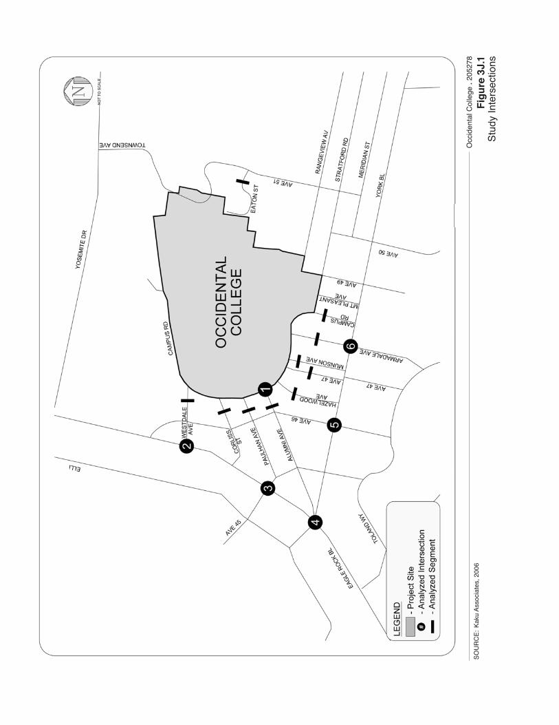
Description of Key Roadways Primary regional access to the study area is provided by the Ventura Freeway (State Route 134), which runs generally in an east/west direction approximately two miles north of the Occidental College campus, and the Glendale Freeway (State Route 2), which runs in a north/south direction approximately one mile west of the campus. Eagle Rock Boulevard, York Boulevard, Yosemite Drive, and Townsend Avenue/Avenue 51 provide area access to the project site. Local access and circulation to the campus is provided by Ridgeview Avenue, Westdale Avenue, Corliss Street, Paulhan Avenue, Alumni Avenue, Hazelwood Avenue, Avenue 47, Minson Avenue, Armadale Avenue, and Campus Road. Table 3J-1 provides a complete description of all the roadways in the study area.
TABLE 3J-1 DESCRIPTION OF EXISTING ROADWAYS IN STUDY AREA
Lane Parking
Restrictions
Segment From To NB/EB SB/WB Median
Type NB/EB SB/WB Speed Limit
Yosemite Drive Westdale Avenue 2 2 RM PA PA 35
Eagle Rock Boulevard Westdale
Avenue York Boulevard 2 3 RM PA PA 35
York Boulevard
Eagle Rock Boulevard Avenue 50 1 2/3 1 2/3 DY PA PA 35
Avenue 46 Eagle Rock Boulevard York Boulevard 1 1 UD PA PA 25
Corliss Street Eagle Rock Boulevard Campus Road 1 1 UD PA PA 25
Paulhan Avenue Avenue 45 Campus Road 1 1 UD PA PA 25
Alumni Avenue
Eagle Rock Boulevard Campus Road 1 1 UD PA PA 25
Armdale Avenue York Boulevard Campus Road 1 1 UD PA PA 25
Avenue 49 York Boulevard Stratford Road 1 1 UD PA PA 25
Campus Road Escarpa Drive York Boulevard 1 1 UD PA PA 25
Ridgeview Avenue Avenue 46 Campus Road 1 1 UD PA PA 25
Townsend Avenue Avenue 51 Yosemite Drive 1 1 SDY NSAT NSAT 30
Avenue 51 York Boulevard Townsend Avenue 2 2 SDY PA PA 30
MEDIAN TYPE: DY = Double Yellow Centerline RM = Raised Median SDY = Single Dashed Yellow Centerline UD = Undivided Lane
PARKING: PA = Parking Allowed NSAT = No Stopping Anytime
LANES: # = Number of lanes 2/3 = Shared Parking/Driving Lane NB = North Bound EB = East Bound SB = South Bound WB = West Bound
SOURCE: Fehr & Peers/Kaku Associates, 2008.
3. Environmental Setting, Impacts and Mitigation Measures 3J. Transportation, Circulation and Parking
Occidental College Specific Plan 3J-4 ESA / D205278 Draft EIR September 2008
Existing Transit Service The project study area is served by bus transit lines operated by the MTA, one by the Los Angeles Department of Transportation (LADOT) through its Downtown Area Shuttle (DASH) service.
MTA Transit Service MTA Bus Line 83 runs along York Boulevard from Eagle Rock Boulevard near Occidental College to Piedmont Avenue. It then travels along Figueroa Street and Broadway to downtown Los Angeles. This line is located approximately 0.20 of a mile south of the project site.
MTA Bus Line 84 runs mainly along Broadway, Colorado Boulevard, Eagle Rock Boulevard and Cypress Avenue to downtown Los Angeles. This line is located approximately 0.20 of a mile northwest of the project site.
MTA Bus Line 181 begins at the Sierra Madre Villa Transportation Center (Metro Gold Line) and travels along Colorado Boulevard, Broadway, Los Feliz Boulevard, Franklin Avenue to the Hollywood/Vine Metro Red Line Station. Within the study area, it operates along Yosemite Drive. This line is located approximately 0.3 of a mile north of the project site.2
LADOT (DASH Service) DASH Highland Park/Eagle Rock (HPER) begins at Eagledale Avenue and Colorado Street and then runs mainly along Colorado Street/Boulevard,3 Yosemite Drive, Townsend Avenue/Avenue 51, and then Figueroa Street to Pascuala Avenue. This line has a stop which is located directly adjacent to the eastern boarder of the project site.
Methodology
Study Scenarios Weekday AM and PM peak hour traffic operations were evaluated at the study intersections for each of the following traffic scenarios:
• Existing (Year 2006) Conditions; • Future (Year 2028) Cumulative Base (No Project) Conditions; and • Future (Year 2028) Cumulative and Proposed Project Conditions.
Existing Period Conditions Weekday morning and evening peak hour traffic counts were conducted at the analyzed intersections on Thursday, October 19, 2006. This date was chosen because it falls within the early to middle part of Occidental College’s fall semester and data reflects a typical travel pattern for campus activities.
2 There is no direct route from the campus to Yosemite Drive. Riders would have to walk an estimated 0.70 of a mile
to ride MTA bus line 181. 3 Colorado Street becomes Colorado Boulevard at Broadway.
3. Environmental Setting, Impacts and Mitigation Measures 3J. Transportation, Circulation and Parking
Occidental College Specific Plan 3J-5 ESA / D205278 Draft EIR September 2008
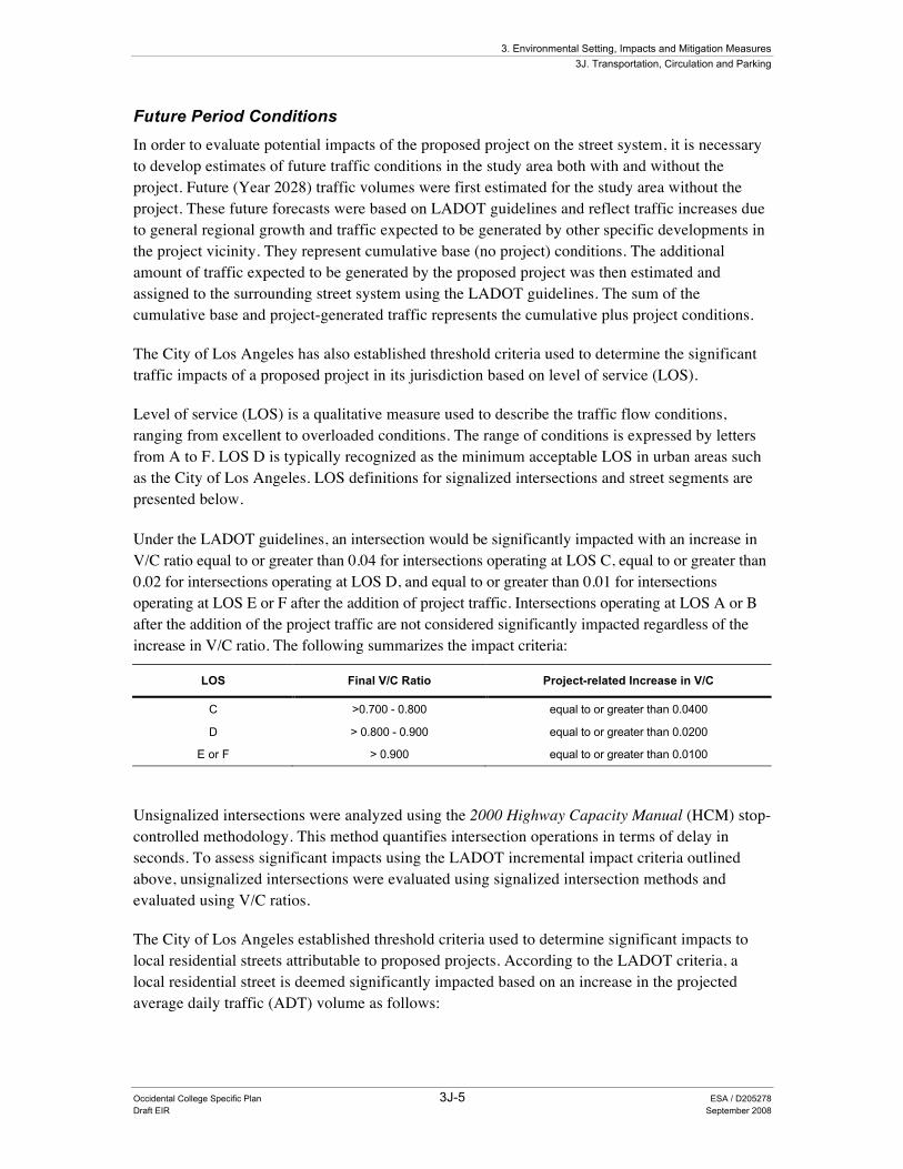
Future Period Conditions In order to evaluate potential impacts of the proposed project on the street system, it is necessary to develop estimates of future traffic conditions in the study area both with and without the project. Future (Year 2028) traffic volumes were first estimated for the study area without the project. These future forecasts were based on LADOT guidelines and reflect traffic increases due to general regional growth and traffic expected to be generated by other specific developments in the project vicinity. They represent cumulative base (no project) conditions. The additional amount of traffic expected to be generated by the proposed project was then estimated and assigned to the surrounding street system using the LADOT guidelines. The sum of the cumulative base and project-generated traffic represents the cumulative plus project conditions.
The City of Los Angeles has also established threshold criteria used to determine the significant traffic impacts of a proposed project in its jurisdiction based on level of service (LOS).
Level of service (LOS) is a qualitative measure used to describe the traffic flow conditions, ranging from excellent to overloaded conditions. The range of conditions is expressed by letters from A to F. LOS D is typically recognized as the minimum acceptable LOS in urban areas such as the City of Los Angeles. LOS definitions for signalized intersections and street segments are presented below. Under the LADOT guidelines, an intersection would be significantly impacted with an increase in V/C ratio equal to or greater than 0.04 for intersections operating at LOS C, equal to or greater than 0.02 for intersections operating at LOS D, and equal to or greater than 0.01 for intersections operating at LOS E or F after the addition of project traffic. Intersections operating at LOS A or B after the addition of the project traffic are not considered significantly impacted regardless of the increase in V/C ratio. The following summarizes the impact criteria:
LOS Final V/C Ratio Project-related Increase in V/C
C >0.700 - 0.800 equal to or greater than 0.0400
D > 0.800 - 0.900 equal to or greater than 0.0200
E or F > 0.900 equal to or greater than 0.0100
Unsignalized intersections were analyzed using the 2000 Highway Capacity Manual (HCM) stop-controlled methodology. This method quantifies intersection operations in terms of delay in seconds. To assess significant impacts using the LADOT incremental impact criteria outlined above, unsignalized intersections were evaluated using signalized intersection methods and evaluated using V/C ratios.
The City of Los Angeles established threshold criteria used to determine significant impacts to local residential streets attributable to proposed projects. According to the LADOT criteria, a local residential street is deemed significantly impacted based on an increase in the projected average daily traffic (ADT) volume as follows:
3. Environmental Setting, Impacts and Mitigation Measures 3J. Transportation, Circulation and Parking
Occidental College Specific Plan 3J-6 ESA / D205278 Draft EIR September 2008
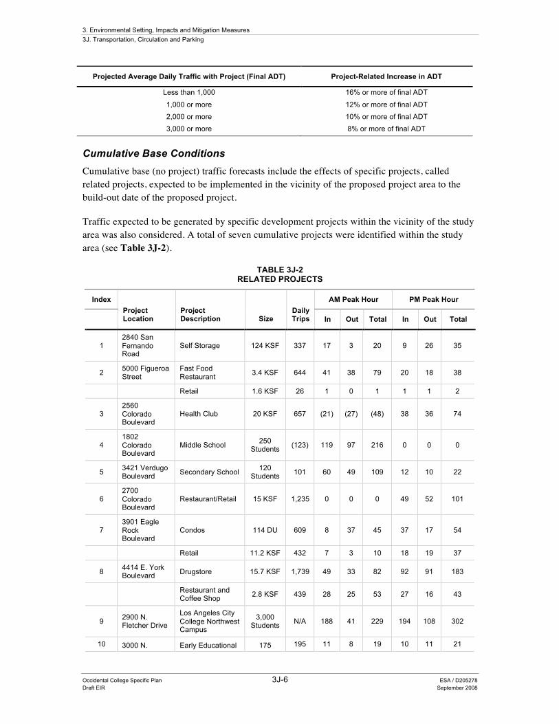
Projected Average Daily Traffic with Project (Final ADT) Project-Related Increase in ADT
Less than 1,000 16% or more of final ADT
1,000 or more 12% or more of final ADT
2,000 or more 10% or more of final ADT
3,000 or more 8% or more of final ADT
Cumulative Base Conditions Cumulative base (no project) traffic forecasts include the effects of specific projects, called related projects, expected to be implemented in the vicinity of the proposed project area to the build-out date of the proposed project.
Traffic expected to be generated by specific development projects within the vicinity of the study area was also considered. A total of seven cumulative projects were identified within the study area (see Table 3J-2).
TABLE 3J-2 RELATED PROJECTS
Index AM Peak Hour PM Peak Hour
Project Location
Project Description Size
Daily Trips In Out Total In Out Total
1 2840 San Fernando Road
Self Storage 124 KSF 337 17 3 20 9 26 35
2 5000 Figueroa Street
Fast Food Restaurant 3.4 KSF 644 41 38 79 20 18 38
Retail 1.6 KSF 26 1 0 1 1 1 2
3 2560 Colorado Boulevard
Health Club 20 KSF 657 (21) (27) (48) 38 36 74
4 1802 Colorado Boulevard
Middle School 250 Students (123) 119 97 216 0 0 0
5 3421 Verdugo Boulevard Secondary School 120
Students 101 60 49 109 12 10 22
6 2700 Colorado Boulevard
Restaurant/Retail 15 KSF 1,235 0 0 0 49 52 101
7 3901 Eagle Rock Boulevard
Condos 114 DU 609 8 37 45 37 17 54
Retail 11.2 KSF 432 7 3 10 18 19 37
8 4414 E. York Boulevard Drugstore 15.7 KSF 1,739 49 33 82 92 91 183
Restaurant and Coffee Shop 2.8 KSF 439 28 25 53 27 16 43
9 2900 N. Fletcher Drive
Los Angeles City College Northwest Campus
3,000 Students N/A 188 41 229 194 108 302
10 3000 N. Early Educational 175 195 11 8 19 10 11 21
3. Environmental Setting, Impacts and Mitigation Measures 3J. Transportation, Circulation and Parking
Occidental College Specific Plan 3J-7 ESA / D205278 Draft EIR September 2008
Index AM Peak Hour PM Peak Hour
Project Location
Project Description Size
Daily Trips In Out Total In Out Total
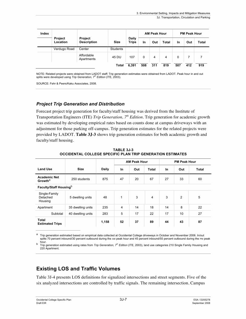
Verdugo Road Center Students
Affordable Apartments 45 DU 107 0 4 4 0 7 7
Total 6,391 508 311 819 507 412 919 NOTE: Related projects were obtained from LADOT staff; Trip generation estimates were obtained from LADOT. Peak hour in and out splits were developed using Trip Generation, 7th Edition (ITE, 2003). SOURCE: Fehr & Peers/Kaku Associates, 2008.
Project Trip Generation and Distribution Forecast project trip generation for faculty/staff housing was derived from the Institute of Transportation Engineers (ITE) Trip Generation, 7th Edition. Trip generation for academic growth was estimated by developing empirical rates based on counts done at campus driveways with an adjustment for those parking off-campus. Trip generation estimates for the related projects were provided by LADOT. Table 3J-3 shows trip generation estimates for both academic growth and faculty/staff housing.
TABLE 3J-3 OCCIDENTAL COLLEGE SPECIFIC PLAN TRIP GENERATION ESTIMATES
AM Peak Hour PM Peak Hour
Land Use Size Daily In Out Total In Out Total
Academic Net Growtha 250 students 875 47 20 67 27 33 60
Faculty/Staff Housingb
Single-Family Detached Housing
5 dwelling units 48 1 3 4 3 2 5
Apartment 35 dwelling units 235 4 14 18 14 8 22
Subtotal 40 dwelling units 283 5 17 22 17 10 27
Total Estimated Trips 1,158 52 37 89 44 43 87
a Trip generation estimated based on empirical data collected at Occidental College driveways in October and November 2006. In/out
splits 70 percent inbound/30 percent outbound during the AM peak hour and 45 percent inbound/55 percent outbound during the PM peak hour.
b Trip generation estimated using rates from Trip Generation, 7th Edition (ITE, 2003), land use categories 210 Single Family Housing and 220 Apartment.
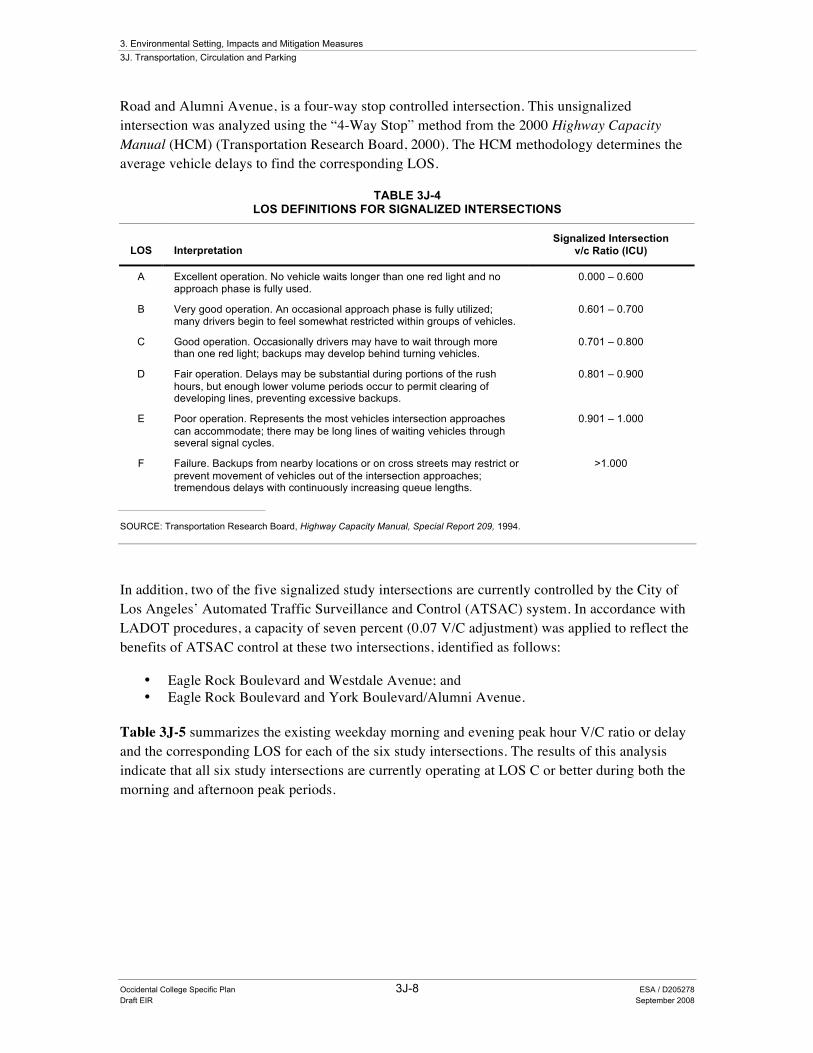
Existing LOS and Traffic Volumes Table 3J-4 presents LOS definitions for signalized intersections and street segments. Five of the six analyzed intersections are controlled by traffic signals. The remaining intersection, Campus
3. Environmental Setting, Impacts and Mitigation Measures 3J. Transportation, Circulation and Parking
Occidental College Specific Plan 3J-8 ESA / D205278 Draft EIR September 2008
Road and Alumni Avenue, is a four-way stop controlled intersection. This unsignalized intersection was analyzed using the “4-Way Stop” method from the 2000 Highway Capacity Manual (HCM) (Transportation Research Board, 2000). The HCM methodology determines the average vehicle delays to find the corresponding LOS.
TABLE 3J-4 LOS DEFINITIONS FOR SIGNALIZED INTERSECTIONS
LOS Interpretation Signalized Intersection
v/c Ratio (ICU)
A Excellent operation. No vehicle waits longer than one red light and no approach phase is fully used.
0.000 – 0.600
B Very good operation. An occasional approach phase is fully utilized; many drivers begin to feel somewhat restricted within groups of vehicles.
0.601 – 0.700
C Good operation. Occasionally drivers may have to wait through more than one red light; backups may develop behind turning vehicles.
0.701 – 0.800
D Fair operation. Delays may be substantial during portions of the rush hours, but enough lower volume periods occur to permit clearing of developing lines, preventing excessive backups.
0.801 – 0.900
E Poor operation. Represents the most vehicles intersection approaches can accommodate; there may be long lines of waiting vehicles through several signal cycles.
0.901 – 1.000
F Failure. Backups from nearby locations or on cross streets may restrict or prevent movement of vehicles out of the intersection approaches; tremendous delays with continuously increasing queue lengths.
>1.000
SOURCE: Transportation Research Board, Highway Capacity Manual, Special Report 209, 1994.
In addition, two of the five signalized study intersections are currently controlled by the City of Los Angeles’ Automated Traffic Surveillance and Control (ATSAC) system. In accordance with LADOT procedures, a capacity of seven percent (0.07 V/C adjustment) was applied to reflect the benefits of ATSAC control at these two intersections, identified as follows:
• Eagle Rock Boulevard and Westdale Avenue; and • Eagle Rock Boulevard and York Boulevard/Alumni Avenue.
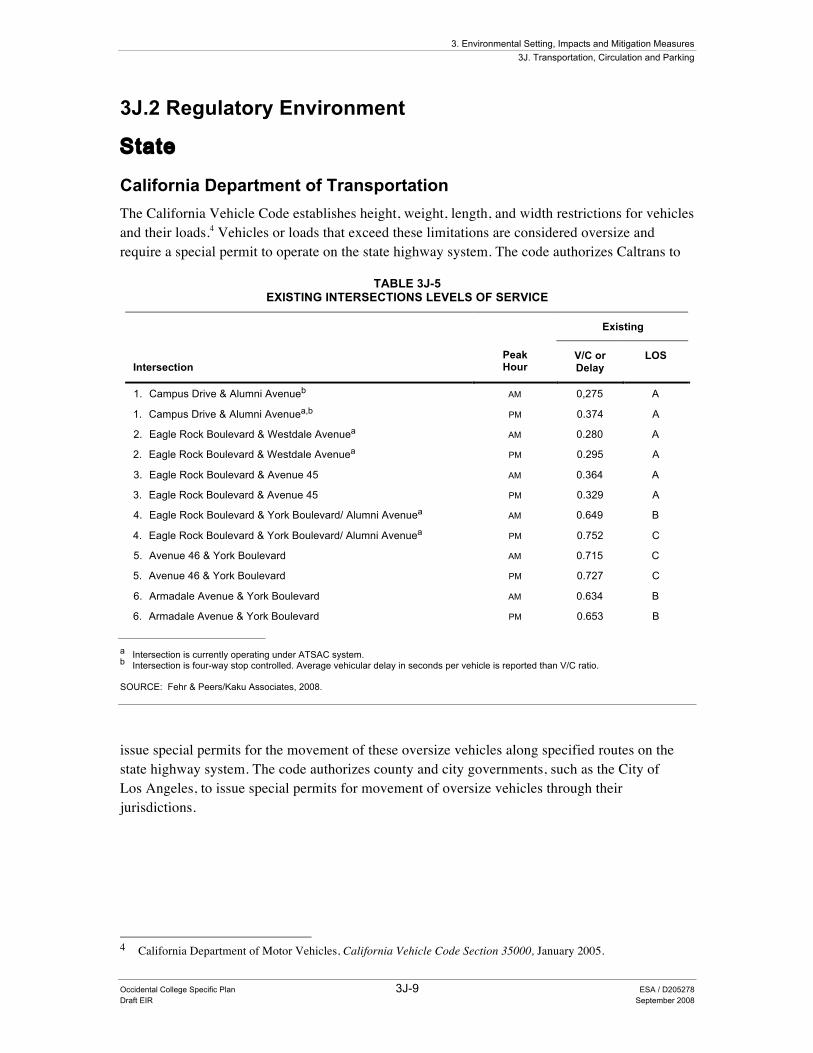
Table 3J-5 summarizes the existing weekday morning and evening peak hour V/C ratio or delay and the corresponding LOS for each of the six study intersections. The results of this analysis indicate that all six study intersections are currently operating at LOS C or better during both the morning and afternoon peak periods.
3. Environmental Setting, Impacts and Mitigation Measures 3J. Transportation, Circulation and Parking
Occidental College Specific Plan 3J-9 ESA / D205278 Draft EIR September 2008
3J.2 Regulatory Environment
State
California Department of Transportation The California Vehicle Code establishes height, weight, length, and width restrictions for vehicles and their loads.4 Vehicles or loads that exceed these limitations are considered oversize and require a special permit to operate on the state highway system. The code authorizes Caltrans to
TABLE 3J-5 EXISTING INTERSECTIONS LEVELS OF SERVICE
Existing
Intersection Peak Hour
V/C or Delay
LOS
1. Campus Drive & Alumni Avenueb AM 0,275 A
1. Campus Drive & Alumni Avenuea,b PM 0.374 A
2. Eagle Rock Boulevard & Westdale Avenuea AM 0.280 A
2. Eagle Rock Boulevard & Westdale Avenuea PM 0.295 A
3. Eagle Rock Boulevard & Avenue 45 AM 0.364 A
3. Eagle Rock Boulevard & Avenue 45 PM 0.329 A
4. Eagle Rock Boulevard & York Boulevard/ Alumni Avenuea AM 0.649 B
4. Eagle Rock Boulevard & York Boulevard/ Alumni Avenuea PM 0.752 C
5. Avenue 46 & York Boulevard AM 0.715 C
5. Avenue 46 & York Boulevard PM 0.727 C
6. Armadale Avenue & York Boulevard AM 0.634 B
6. Armadale Avenue & York Boulevard PM 0.653 B a Intersection is currently operating under ATSAC system. b Intersection is four-way stop controlled. Average vehicular delay in seconds per vehicle is reported than V/C ratio. SOURCE: Fehr & Peers/Kaku Associates, 2008.
issue special permits for the movement of these oversize vehicles along specified routes on the state highway system. The code authorizes county and city governments, such as the City of Los Angeles, to issue special permits for movement of oversize vehicles through their jurisdictions.
4 California Department of Motor Vehicles, California Vehicle Code Section 35000, January 2005.
3. Environmental Setting, Impacts and Mitigation Measures 3J. Transportation, Circulation and Parking
Occidental College Specific Plan 3J-10 ESA / D205278 Draft EIR September 2008
Local
Congestion Management Program (2004) New projects within the County of Los Angeles must comply with the Congestion Management Program (CMP) for Los Angeles County that was adopted by the MTA in November 1995 pursuant to state law (MTA, 1995). The CMP involves monitoring traffic conditions and performance measures on the designated transportation network, analysis of the impact of land use decisions on the transportation network, and mitigation to reduce impacts on the transportation network.
Appendix D of the CMP includes Transportation Impact Assessment (TIA) guidelines (MTA, 1995). The TIA guidelines require analysis at monitored street intersections and segments, including freeway on-and off-ramp intersections where a project is expected to add 50 or more peak hour vehicle trips and mainline freeway or ramp monitoring locations where a project is expected to add 150 or more peak hour trips. If a project does not add, but merely shifts trips at a given monitoring location, the CMP analysis is not required.
City of Los Angeles
LADOT is responsible for transportation issues within the City of Los Angeles. LADOT reviews the transportation/traffic studies prepared for projects of all types for which the City is the lead agency, in addition to other public agency projects (county, state, or federal) located within, or that may affect, the City. LADOT is also responsible for implementing the Los Angeles Municipal Code (LAMC) parking requirements (Section 12.21).
3J.3 Impacts and Mitigation Measures
Methodology
The analytic methodology (including evaluation of existing and future conditions) is discussed above in Environmental Setting starting on p. 3J.4
Criteria for Determining Significance LADOT has established specific threshold criteria that are used to determine if implementation of a project would result in a significant traffic impact. Using these criteria, a proposed project may result in a significant impact on intersection capacity if the estimated project traffic would increase the V/C ratio under one or more of the following conditions:
• V/C ratio increase is equal to or greater than 0.040 and the final LOS (defined as projected future conditions including project, ambient, and related project growth but without project traffic mitigation) is C;
• V/C ratio increase is equal to or greater than 0.020 and the final LOS is D; or
• V/C ratio increase is equal to or greater than 0.010 and the final LOS is E or F.
3. Environmental Setting, Impacts and Mitigation Measures 3J. Transportation, Circulation and Parking
Occidental College Specific Plan 3J-11 ESA / D205278 Draft EIR September 2008
Additionally, the proposed project may result in potentially significant impacts relating to traffic if it would:
• cause an increase in the project-related average daily traffic (ADT) on a residential street if the increases exceed the following project-related increases in ADT:
• cause a substantial increase in traffic in relation to the existing traffic load and capacity of the street system (for example, result in a substantial increase in either the number of vehicle trips, the V/C ratio on roads, or congestion at intersections);
• exceed, either individually or cumulatively, a LOS standard established by the county congestion management agency for designated roads or highways;
• result in inadequate parking capacity; and/or
• result in a cumulatively considerable impact with respect to traffic.
Impact Discussion
Future Traffic Projections Estimates of future traffic conditions both with and without the proposed project are necessary to evaluate the potential impact of the proposed project on the local street system. The cumulative case traffic scenario represents future traffic conditions without the addition of the proposed project, while the cumulative plus project scenario represents future traffic conditions with the development of the proposed project.
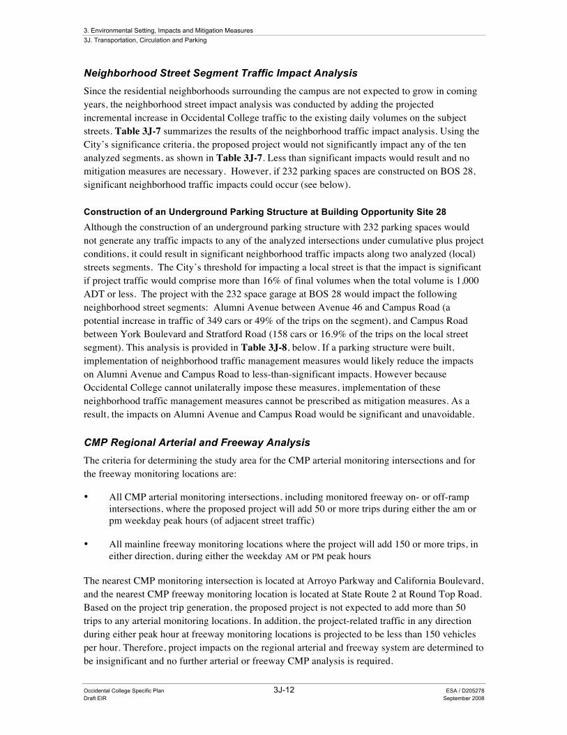
Cumulative Base Traffic Projections The cumulative base traffic projections reflect growth in traffic over existing conditions from two sources. The first source is the ambient growth in traffic, which reflects increases in traffic due to regional growth and development. The second source is growth due to traffic generated by specific projects located within or in the vicinity of the study area. Table 3J-6 summarizes the results of the cumulative base traffic projections analysis. As shown in Table 3J-6, one of the six study intersections (Eagle Rock Boulevard and York Boulevard/Alumni Avenue) was projected to operate at LOS E during the PM peak hour under year 2025 cumulative base conditions. The remaining intersections are projected to operate at LOS D or better during both peak periods.
Cumulative Plus Project Traffic Conditions Also, as shown in Table 3J-6, the proposed project traffic would not result in a V/C increase large enough to result in significant traffic impacts at any of the analyzed intersections during peak hour conditions for cumulative plus project traffic conditions. As such, the proposed development would not generate significant traffic impacts at any of the analyzed intersections under cumulative plus project conditions. Less than significant impacts would result and no mitigation measures are necessary.
3. Environmental Setting, Impacts and Mitigation Measures 3J. Transportation, Circulation and Parking
Occidental College Specific Plan 3J-12 ESA / D205278 Draft EIR September 2008
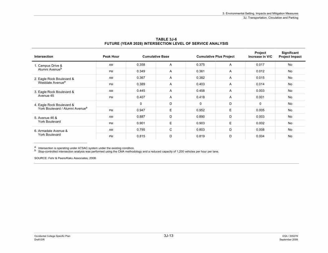
Neighborhood Street Segment Traffic Impact Analysis Since the residential neighborhoods surrounding the campus are not expected to grow in coming years, the neighborhood street impact analysis was conducted by adding the projected incremental increase in Occidental College traffic to the existing daily volumes on the subject streets. Table 3J-7 summarizes the results of the neighborhood traffic impact analysis. Using the City’s significance criteria, the proposed project would not significantly impact any of the ten analyzed segments, as shown in Table 3J-7. Less than significant impacts would result and no mitigation measures are necessary. However, if 232 parking spaces are constructed on BOS 28, significant neighborhood traffic impacts could occur (see below).
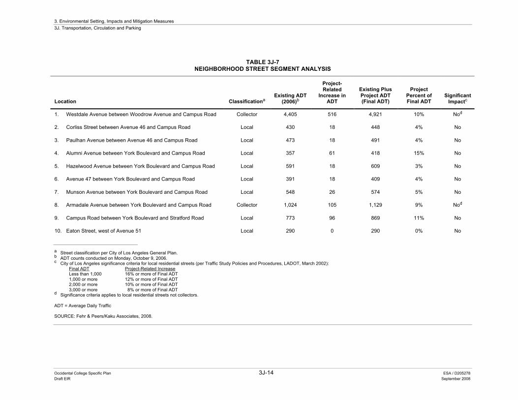
Construction of an Underground Parking Structure at Building Opportunity Site 28 Although the construction of an underground parking structure with 232 parking spaces would not generate any traffic impacts to any of the analyzed intersections under cumulative plus project conditions, it could result in significant neighborhood traffic impacts along two analyzed (local) streets segments. The City’s threshold for impacting a local street is that the impact is significant if project traffic would comprise more than 16% of final volumes when the total volume is 1,000 ADT or less. The project with the 232 space garage at BOS 28 would impact the following neighborhood street segments: Alumni Avenue between Avenue 46 and Campus Road (a potential increase in traffic of 349 cars or 49% of the trips on the segment), and Campus Road between York Boulevard and Stratford Road (158 cars or 16.9% of the trips on the local street segment). This analysis is provided in Table 3J-8, below. If a parking structure were built, implementation of neighborhood traffic management measures would likely reduce the impacts on Alumni Avenue and Campus Road to less-than-significant impacts. However because Occidental College cannot unilaterally impose these measures, implementation of these neighborhood traffic management measures cannot be prescribed as mitigation measures. As a result, the impacts on Alumni Avenue and Campus Road would be significant and unavoidable.
CMP Regional Arterial and Freeway Analysis The criteria for determining the study area for the CMP arterial monitoring intersections and for the freeway monitoring locations are:
• All CMP arterial monitoring intersections, including monitored freeway on- or off-ramp intersections, where the proposed project will add 50 or more trips during either the am or pm weekday peak hours (of adjacent street traffic)
• All mainline freeway monitoring locations where the project will add 150 or more trips, in either direction, during either the weekday AM or PM peak hours
The nearest CMP monitoring intersection is located at Arroyo Parkway and California Boulevard, and the nearest CMP freeway monitoring location is located at State Route 2 at Round Top Road. Based on the project trip generation, the proposed project is not expected to add more than 50 trips to any arterial monitoring locations. In addition, the project-related traffic in any direction during either peak hour at freeway monitoring locations is projected to be less than 150 vehicles per hour. Therefore, project impacts on the regional arterial and freeway system are determined to be insignificant and no further arterial or freeway CMP analysis is required.
3. Environmental Setting, Impacts and Mitigation Measures 3J. Transportation, Circulation and Parking
Occidental College Specific Plan 3J-13 ESA / 205278 Draft EIR September 2008
TABLE 3J-6 FUTURE (YEAR 2028) INTERSECTION LEVEL OF SERVICE ANALYSIS
Intersection Peak Hour Cumulative Base Cumulative Plus Project Project
Increase in V/C Significant
Project Impact
AM 0.358 A 0.375 A 0.017 No 1. Campus Drive & Alumni Avenueb
PM 0.349 A 0.361 A 0.012 No
AM 0.367 A 0.382 A 0.015 No 2. Eagle Rock Boulevard & Westdale Avenuea PM 0.389 A 0.403 A 0.014 No
AM 0.445 A 0.458 A 0.003 No 3. Eagle Rock Boulevard & Avenue 45 PM 0.407 A 0.418 A 0.001 No
0 D 0 D 0 No 4. Eagle Rock Boulevard & York Boulevard / Alumni Avenuea PM 0.947 E 0.952 E 0.005 No
AM 0.887 D 0.890 D 0.003 No 5. Avenue 46 & York Boulevard PM 0.901 E 0.903 E 0.002 No
AM 0.795 C 0.803 D 0.008 No 6. Armadale Avenue & York Boulevard PM 0.815 D 0.819 D 0.004 No
a Intersection is operating under ATSAC system under the existing condition. b Stop-controlled intersection analysis was performed using the CMA methodology and a reduced capacity of 1,200 vehicles per hour per lane. SOURCE: Fehr & Peers/Kaku Associates, 2008.
3. Environmental Setting, Impacts and Mitigation Measures 3J. Transportation, Circulation and Parking
Occidental College Specific Plan 3J-14 ESA / D205278 Draft EIR September 2008
TABLE 3J-7 NEIGHBORHOOD STREET SEGMENT ANALYSIS
Location Classificationa Existing ADT
(2006)b
Project-Related
Increase in ADT
Existing Plus Project ADT (Final ADT)
Project Percent of Final ADT
Significant Impactc
1. Westdale Avenue between Woodrow Avenue and Campus Road Collector 4,405 516 4,921 10% Nod
2. Corliss Street between Avenue 46 and Campus Road Local 430 18 448 4% No
3. Paulhan Avenue between Avenue 46 and Campus Road Local 473 18 491 4% No
4. Alumni Avenue between York Boulevard and Campus Road Local 357 61 418 15% No
5. Hazelwood Avenue between York Boulevard and Campus Road Local 591 18 609 3% No
6. Avenue 47 between York Boulevard and Campus Road Local 391 18 409 4% No
7. Munson Avenue between York Boulevard and Campus Road Local 548 26 574 5% No
8. Armadale Avenue between York Boulevard and Campus Road Collector 1,024 105 1,129 9% Nod
9. Campus Road between York Boulevard and Stratford Road Local 773 96 869 11% No
10. Eaton Street, west of Avenue 51 Local 290 0 290 0% No
a Street classification per City of Los Angeles General Plan. b ADT counts conducted on Monday, October 9, 2006. c City of Los Angeles significance criteria for local residential streets (per Traffic Study Policies and Procedures, LADOT, March 2002):
Final ADT Project-Related Increase Less than 1,000 16% or more of Final ADT 1,000 or more 12% or more of Final ADT 2,000 or more 10% or more of Final ADT 3,000 or more 8% or more of Final ADT
d Significance criteria applies to local residential streets not collectors. ADT = Average Daily Traffic SOURCE: Fehr & Peers/Kaku Associates, 2008.
3. Environmental Setting, Impacts and Mitigation Measures 3J. Transportation, Circulation and Parking
Occidental College Specific Plan 3J-15 ESA / D205278 Draft EIR September 2008
TABLE 3J-8 NEIGHBORHOOD STREET SEGMENT ANALYSIS
WITH 232 UNDERGOUND PARKING SPACES IN BUILDING OPPORTUNITY SITE 28
Location Classificationa Existing ADT
(2006)b
Project-Related
Increase in ADT
Existing Plus Project ADT (Final ADT)
Project Percent of Final ADT
Significant Impactc
11. Westdale Avenue between Woodrow Avenue and Campus Road Collector 4,405 167 4,572 4% Nod
12. Corliss Street between Avenue 46 and Campus Road Local 430 13 443 3% No
13. Paulhan Avenue between Avenue 46 and Campus Road Local 473 72 545 13% No
14. Alumni Avenue between York Boulevard and Campus Road Local 357 349 706 49% Yes
15. Hazelwood Avenue between York Boulevard and Campus Road Local 591 18 609 3% No
16. Avenue 47 between York Boulevard and Campus Road Local 391 21 412 5% No
17. Munson Avenue between York Boulevard and Campus Road Local 548 28 576 5% No
18. Armadale Avenue between York Boulevard and Campus Road Collector 1,024 229 1,253 18% Nod
19. Campus Road between York Boulevard and Stratford Road Local 773 158 931 16.9% Yes
20. Eaton Street, west of Avenue 51 Local 290 0 290 0% No
a Street classification per City of Los Angeles General Plan. b ADT counts conducted on Monday, October 9, 2006. c City of Los Angeles significance criteria for local residential streets (per Traffic Study Policies and Procedures, LADOT, March 2002):
Final ADT Project-Related Increase Less than 1,000 16% or more of Final ADT 1,000 or more 12% or more of Final ADT 2,000 or more 10% or more of Final ADT 3,000 or more 8% or more of Final ADT
d Significance criteria applies to local residential streets. ADT = Average Daily Traffic SOURCE: Fehr & Peers/Kaku Associates, 2008.
3. Environmental Setting, Impacts and Mitigation Measures 3J. Transportation, Circulation and Parking
Occidental College Specific Plan 3J-16 ESA / 205278 Draft EIR September 2008
Parking Impact Analysis The proposed Specific Plan determined that there are currently more parking spaces serving the Occidental College campus than necessary to satisfy the campus parking demand. The Specific Plan proposes to remove 390 excess parking spaces on the campus to extend walkways and improve landscaping, and to create a pedestrian zone at the core of the campus. The spaces would be removed in two steps: 282 spaces would be removed in the near future and the remaining 108 spaces would be removed over the 20-year period of the Specific Plan. The Specific Plan proposes a parking monitoring strategy to ensure that the spaces to be removed are in fact excess, with excess defined as spaces in excess of the campus demand plus a 10 percent contingency/circulation cushion. Subsequently, if no excess of on-street and on-campus parking spaces remain, as determined by continuous parking monitoring, the 390 parking spaces proposed to be removed would not be removed. Implementation of Measure 3J.2 would ensure that parking is not removed if it is not excess parking, thereby reducing the potential for insufficient parking to a less than significant impact.
Campus Parking Demand Projections
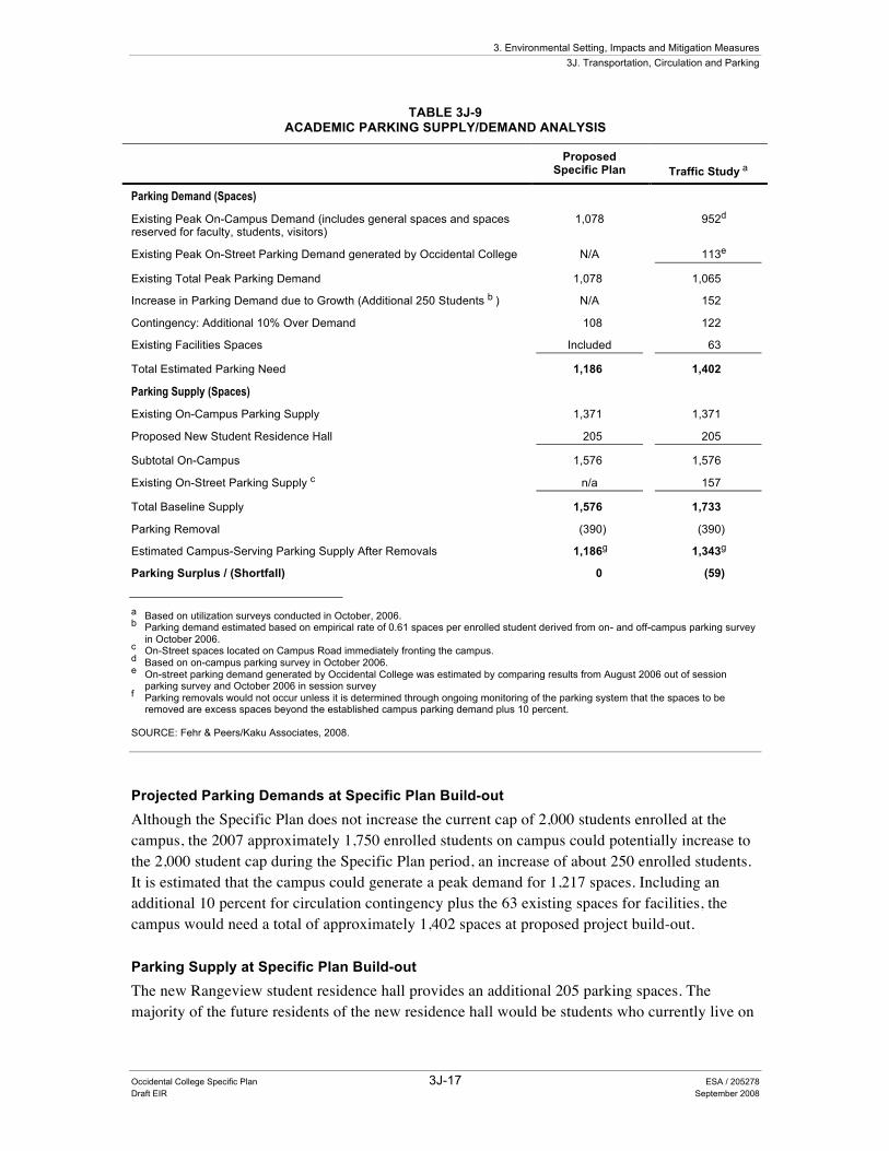
The parking analysis for the proposed project was conducted using customized parking demand rates established for Occidental College. A parking model based on campus utilization surveys conducted in August (out of session) and October (in session) 2006 found that the peak academic parking demand rate for Occidental College is approximately 0.61 spaces per enrolled student. The estimated current and projected future campus parking demands and supplies are shown in Table 3J-9.
Existing Parking Supply A total of 1,371 spaces are currently provided on the campus (including spaces temporarily closed due to construction of the new student residence hall); this number rises to 1,576 with opening of the new Rangeview Residence Hall. An estimated 157 on-street parking spaces fronting the campus side of Campus Road are considered to be available for use by campus students, faculty/staff and visitors. Thus, a total of 1,528 existing parking spaces are available for college-related activities (rising to 1,733 with opening of the new student Residence Hall).
Existing Parking Demand As shown in Table 3J-9, the observed peak on-campus parking demand was 952 occupied spaces. The on-street parking demand generated by the college was derived from the differences between August and October surveys, which represent out of- and in-session respectively. At the campus peak time of 11 AM to 12 PM, the difference in on-street parking utilization between the August and October surveys that was attributed to campus-generated demands was 113 occupied spaces. The results of the parking utilization surveys indicate that the estimated peak parking demand generated by the Occidental College campus is approximately 1,065 spaces at about 11 AM.
3. Environmental Setting, Impacts and Mitigation Measures 3J. Transportation, Circulation and Parking
Occidental College Specific Plan 3J-17 ESA / 205278 Draft EIR September 2008
TABLE 3J-9 ACADEMIC PARKING SUPPLY/DEMAND ANALYSIS
Proposed Specific Plan Traffic Study a
Parking Demand (Spaces)
Existing Peak On-Campus Demand (includes general spaces and spaces reserved for faculty, students, visitors)
1,078 952d
Existing Peak On-Street Parking Demand generated by Occidental College N/A 113e
Existing Total Peak Parking Demand 1,078 1,065
Increase in Parking Demand due to Growth (Additional 250 Students b ) N/A 152
Contingency: Additional 10% Over Demand 108 122
Existing Facilities Spaces Included 63
Total Estimated Parking Need 1,186 1,402
Parking Supply (Spaces)
Existing On-Campus Parking Supply 1,371 1,371
Proposed New Student Residence Hall 205 205
Subtotal On-Campus 1,576 1,576
Existing On-Street Parking Supply c n/a 157
Total Baseline Supply 1,576 1,733
Parking Removal (390) (390)
Estimated Campus-Serving Parking Supply After Removals 1,186g 1,343g
Parking Surplus / (Shortfall) 0 (59) a Based on utilization surveys conducted in October, 2006. b Parking demand estimated based on empirical rate of 0.61 spaces per enrolled student derived from on- and off-campus parking survey
in October 2006. c On-Street spaces located on Campus Road immediately fronting the campus. d Based on on-campus parking survey in October 2006. e On-street parking demand generated by Occidental College was estimated by comparing results from August 2006 out of session
parking survey and October 2006 in session survey f Parking removals would not occur unless it is determined through ongoing monitoring of the parking system that the spaces to be
removed are excess spaces beyond the established campus parking demand plus 10 percent. SOURCE: Fehr & Peers/Kaku Associates, 2008.
Projected Parking Demands at Specific Plan Build-out Although the Specific Plan does not increase the current cap of 2,000 students enrolled at the campus, the 2007 approximately 1,750 enrolled students on campus could potentially increase to the 2,000 student cap during the Specific Plan period, an increase of about 250 enrolled students. It is estimated that the campus could generate a peak demand for 1,217 spaces. Including an additional 10 percent for circulation contingency plus the 63 existing spaces for facilities, the campus would need a total of approximately 1,402 spaces at proposed project build-out.
Parking Supply at Specific Plan Build-out The new Rangeview student residence hall provides an additional 205 parking spaces. The majority of the future residents of the new residence hall would be students who currently live on
3. Environmental Setting, Impacts and Mitigation Measures 3J. Transportation, Circulation and Parking
Occidental College Specific Plan 3J-18 ESA / 205278 Draft EIR September 2008
campus. Thus, the residence hall would not generate any additional traffic or parking demand (Traffic Study for the Occidental College Student Residence Conditional Use Permit, Kaku Associates, Inc., June 2005). Completion of the residence hall increases the total supply of parking serving the Occidental College campus to about 1,733 spaces.
The Specific Plan proposes to remove a total of 390 parking spaces for landscape and pedestrian improvements. With these removals, a total of 1,343 parking spaces would be available in on-campus parking facilities and on-street spaces immediately adjacent to the campus.
Comparison of Projected Demand to Proposed Supply As Table 3J-9 illustrates, there could be a projected shortage of approximately 59 parking spaces. The Specific Plan parking strategy, however, is self-mitigating since the Specific Plan provides that the long-term Stage 2 parking removals would not occur unless it is determined through ongoing monitoring of the parking system that the spaces to be removed are excess spaces beyond the established campus parking demand plus 10 percent. Therefore, the projected shortfall would not result in a parking impact since the spaces would not be removed if the need could not be accommodated. Implementation of Measure 3J.2 would further ensure that parking that is needed would not be removed.
To ensure that the spaces would not be needed, however, the monitoring system should not only include annual utilization surveys of the campus but should also consider campus-generated on-street demands and should allow for the possibility of an increase in demand if the number of enrolled students at the time of the survey is below the 2,000 student cap.
The estimated 59-space shortfall represents only about 4 percent of the projected total future need of 1,402 spaces. If the College were to be successful in reducing demands over time via implementation of transportation demand management (TDM) and/or demand reduction measures, it appears possible that the ongoing monitoring could ultimately allow removal of many of the spaces identified in the Specific Plan. Thus, with implementation of Mitigation Measure 3J.1 and Mitigation Measure 3J.2 and the proposed development of pedestrian walkways, parking issues would be a less than significant impact.
During special events, such as graduation ceremonies, large athletic events, weddings, and concerts, on-campus parking is utilized. The traffic study (Fehr & Peers, 2007) indicates that its information was based on typical Average Vehicle Occupancy (AVO) for related uses, which estimate approximately 2.5 persons per vehicle for performing arts theaters and 3.0 persons per vehicle for athletic events. The largest events include Occidental College commencement (1,430 vehicles at 3.5 AVO), Eagle Rock High School graduation (1,290 vehicles at 3.5 AVO), football games (870 vehicles at 3.0 AVO), Eagle Rock relays track meet (1,000 vehicles at 3.0 AVO), and the Oxy Invitational track meet (330 vehicles at 3.0 AVO). Assuming an AVO of 1.5 to 2.5 for conference/seminars and AVOs of 2.5 to 3.0 for large events such as a capacity event in Rush Gymnasium or at Bird Theater, there would be insufficient parking available. Implementation of Mitigation Measure 3J.3 would reduce impacts related to insufficient parking during large events to a less-than-significant impact.
3. Environmental Setting, Impacts and Mitigation Measures 3J. Transportation, Circulation and Parking
Occidental College Specific Plan 3J-19 ESA / 205278 Draft EIR September 2008
Site Access
Main Campus Access Vehicular access into and out of the Occidental College campus during the proposed project implementation would continue to be obtained via the existing driveways located along Campus Road.
Faculty/Staff Multi-Family Housing Access Access to the faculty/staff multi-family housing proposed for development on the eastern side of the campus would be via a new driveway connecting to Townsend Avenue.
The proposed new driveway onto Townsend Avenue serving the multifamily housing would intersect Townsend Avenue on the outside of a curve at the crest of the hill. Implementation of Mitigation Measure 3J.4 would configure and control this intersection. With proposed stop signs and re-striping of Townsend Avenue, the stop-controlled movements on the driveway approach are projected to operate at LOS C during the AM peak hour and LOS B during the PM peak hour, while the through movements on Townsend Avenue would be uncontrolled. Furthermore, in addition to field observations indicating that vehicles approaching on Townsend Avenue would be visible, there would be no increase in hazards due to its design features and less than significant impacts would result.
Faculty/Staff Single-Family Housing Access The Specific Plan indicates that the proposed faculty/staff single-family housing would be accessed via individual driveways directly onto Townsend Avenue. These driveways would be onto the steep portion of the hill on Townsend Avenue in an area that currently has no side access and no on-street parking. However, with the implementation of Mitigation Measure 3J.5 less than significant impacts would occur.
Mitigation Measures The following measures shall apply to the proposed project to reduce traffic and circulation impacts:
Measure 3J.1: Transportation Demand Management. To reduce the demand for parking to minimal possible levels, to the greatest extent feasible the following Transportation Demand Management measures shall be implemented:
• Education. Occidental College shall provide education and awareness training and materials to students and employees regarding the TDM program, availability of transit, alternatives to single occupancy vehicles (SOV) and the motivation for participating in the TDM program.
o Post in areas on campus information for students about MTA (B-TAP, EZ, and student) passes, transit routes and times, and information on alternative transportation and commuting options.
• Commuting Alternatives. Occidental College shall support alternatives to commuting and shall support transit, biking, walking, carpooling and vanpooling.
3. Environmental Setting, Impacts and Mitigation Measures 3J. Transportation, Circulation and Parking
Occidental College Specific Plan 3J-20 ESA / 205278 Draft EIR September 2008
• Staff Trip reduction. For employees, Occidental College shall subsidize MTA passes (B-TAP or EZ Pass) and/or provide other compensation, prizes, or awards to ride-sharers, and shall provide guaranteed rides home.
• Provide adequate, secure bike racks and showers for those using bicycles.
• Occidental College shall provide preferential parking to high occupancy vehicles and shuttle services. Also, Occidental College shall designate ample car pool and/or van pool parking to more than meet demand.
• Occidental College shall follow applicable City of Los Angeles TDM regulations (LAMC 12.26.J3).
Measure 3J.2: Long-term Stage 2 parking removals shall not occur unless it is determined through ongoing monitoring of the parking system that the parking spaces to be removed are excess spaces beyond the established campus parking demand plus 10 percent. Therefore, the projected shortfall would not result in a parking impact since the spaces would not be removed if the need could not be accommodated. To ensure that the spaces would not be needed, however, the monitoring system should not only include annual utilization surveys of the campus but should also consider campus-generated on-street demands and should allow for the possibility of increased demands if the number of enrolled students at the time of the survey is below the 2,000 student cap.
Measure 3J.3: During special events, Occidental College shall adopt all of the following measures:
• Develop and implement a special event management plan for the largest events such as commencement, whereby arrangements are made to ensure that utilization of all available spaces on campus is maximized, to encourage carpooling, and to park attendees on surrounding streets. Parking attendees at remote locations with connecting shuttle service could also be considered for the largest events.
• Develop and implement a special event management plan for weeknight and weekend events to ensure that utilization of all available spaces on campus is maximized and, if necessary, restrict attendance. The special event management plan for weeknight and weekend events shall address potential options such as valet parking, and/or arrangements for the use of parking lots off-campus and the use of shuttle service from off-campus locations to events.
• Limit daytime events to the size supported by the available parking capacity.
Measure 3J.4: Occidental College shall implement one of the following mitigation measures:
a. The Occidental College shall control the multi-family faculty/staff housing driveway approach to Townsend Avenue with a stop sign and re-stripe Townsend Avenue to provide a left-turn storage pocket. With this control, the stop-controlled movements on the driveway approach are projected to operate at LOS C during the AM peak hour and LOS B during the PM peak hour, while the through movements on Townsend Avenue would be uncontrolled.
- or -
3. Environmental Setting, Impacts and Mitigation Measures 3J. Transportation, Circulation and Parking
Occidental College Specific Plan 3J-21 ESA / 205278 Draft EIR September 2008
b. Occidental College shall install stop-signs controlling all three following approaches (i.e., the two Townsend Avenue approaches as well as the driveway approach). This would be similar to other existing intersections along Townsend Avenue, such as Townsend Avenue/Avenue 51 to the southeast and Townsend Avenue/Grove Drive to the north and would be consistent with Townsend Avenue’s classification in the City of Los Angeles General Plan as a collector street. With all-way stop control, a left-turn pocket would not be necessary on Townsend Avenue. With this control, the intersection is projected to operate at LOS B during both the AM and PM peak hours.
Measure 3J.5: The driveways near faculty/staff single-family housing shall be designed with off-street turnaround capability located between the vehicle parking area and the street so that the potential for backing maneuvers onto Townsend Avenue is minimized. In addition, sufficient off-street parking area should be provided at each residence (not including the turnaround area) for both resident and guest vehicles, since on-street parking is prohibited on the Townsend Avenue grade.
Measure 3J.6: If 232 parking spaces are developed on BOS 28, Occidental College shall work with LADOT and the neighboring community to implement a Neighborhood Traffic Management Plan that shall include traffic calming measures. If the neighbors agree that these solutions are workable, the improvement(s) would be installed on a trial basis. Once the improvements have been in place for a sufficient trial (usually six months), and the neighbors approve, the improvements would be installed permanently.
Although this measure is feasible, Occidental College cannot unilaterally impose these measures, and the measure cannot be assured, therefore this EIR considers the impact on two neighborhood streets to remain significant and unavoidable if BOS 28 is developed with 232 parking spaces.
3J.4 Cumulative Impacts As described above, the proposed project would not generate significant traffic impacts under cumulative traffic conditions.
3J.5 Significance after Mitigation Less than significant impacts would occur to parking and street intersections due to proposed project implementation. If 232 parking spaces were constructed on BOS 28, the impact to two local street segments (Alumni Avenue between York Boulevard and Campus Road and Campus Road between York Boulevard and Stratford Road) would remain significant.