Embed Size (px)
Citation preview

Part 2
Sector Action Plans


Final Report, December 2012 The Project for Tirana Thematic Urban Planning
11 - 1
11. Action Plan for Road and Urban Transportation11.1 General
In this chapter, implementation plans are studied and formulated for the three priority projects in the road and urban transportation sector; namely, 1) Outer Ring Road (North Section), 2) Inner/Middle Ring Missing Links Development, and 3) Integrated Public Transport and Parking Development Projects. Locations of these three priority projects are presented in Figure 11.1.1.
1
1) Development of Outer Ring Road (North Section)
2) Inner/Middle Ring Missing Links Development
1) Integrated Public Transport and Parking Development• Tramlines Development• Dedicated Bus Lanes Development• Removal of On-street Parking and Supply of Parking Facilities along with
Parking Pricing
Source: JICA Study Team
Figure 11.1.1 Location of Three Priority Projects in Road and Urban Transportation Sector
(1) Outer Ring Road (North Section) Project � RUT 1-2-2: Development of Outer Ring Road - North Section
Since the traffic demand on the east section of the Outer Ring Road is expected to be small, only the north section is focused on for a priority project.
(2) Inner/Middle Ring Missing Links Development Project � RUT 1-3-1: Development of Inner Ring Road
� RUT 1-3-3: Development of Middle Ring Road
The above ring road projects, which form the structure of the strategic road network, are combined as a missing link development project.
(3) Integrated Public Transport and Parking Development Project
There are three sub-projects that are closely related to each other and thus need to be evaluated

Final Report, December 2012 The Project for Tirana Thematic Urban Planning
11 - 2
together as one project package.
1) Tramlines Development
� RUT 3-1-1: East-West (Kinostudio-Kombinat) Tramline Development
� RUT 3-1-2: North-South (Student City-Intermodal Terminal) Tramline Development
In order to develop the above two tramlines of which passenger demand volumes are expected to be large, it is necessary to secure the ROW of the tramlines and the existing road capacity as well as to relocate the existing Tirana station as shown below.
� RUT 1-4-1: Development of Radial Road: Dibra Road
� RUT 1-4-4: Development of Radial Road: Aleksander Moisiu Road
� RUT 1-4-7: Development of Radial Road: Kavaja Road
� RUT 3-3-1: Relocation of Tirana Railway Station
2) Dedicated Bus Lanes Development
� RUT 2-2-1: Development of Dedicated Bus Lanes
� RUT 3-2-1: Restructuring City/Commune Bus Lines
Development of the bus lines along with dedicated bus lanes will practically realize a BRT-like operation. Hence, it should be promoted as another key project for public transport development. In addition, it is necessary to secure the ROW of the dedicated bus lanes and the existing road capacity, and thus the following radial road development projects should also be included in the priority project package.
� RUT 1-4-2: Development of Radial Road: Hoxha Tahsim & Xhanfize Keko Road
� RUT 1-4-3: Development of Radial Road: Komuna e Parisit & Medar Shtylla Road
3) Removal of On-street Parking and Supply of Parking Facilities along with Parking Pricing
Removal of on-street parking from the above-listed radial roads is essential to recover the original capacity of the primary roads and to realize the development of tramlines and dedicated bus lanes. In order to prepare for that, the following development of parking facilities should also be necessary to accommodate the on-street parking that is to be cleared.
� RUT 2-3-1: Development of Parking Facilities/Parking Information System
� RUT 2-3-2: Parking Pricing System in CBD
Final Report, December 2012 The Project for Tirana Thematic Urban Planning
11 - 3
11.2 Outer Ring Road (North Section) Project 11.2.1 Background and Objective
The north section of the Outer Ring Road (total length: 21.4km), which was proposed as one of the road development components in the action plans, is a priority project for further study. The total length of the project road is around 8.1km, excluding the Tirana River access roads (refer to Figure 11.2.1).
Source: JICA Study Team
Figure 11.2.1 Location of Priority Project 1 (RUT 1-2-2)
The Outer Ring Road project aims to eliminate the through traffic (which has neither origin nor destination in Tirana) in the city. Hence, ideally speaking, the through traffic should be eliminated from the urban area, thereby relieving the urban area of traffic congestion and improving the urban environment. On the other hand, it also aims to promote sub-center developments. Furthermore, traffic volume of Outer Ring Road may be different from section to section. It is also an important freight corridor of Tirana, which is located on the Pan-European Transport Corridor VIII.
Construction of the northern section of the Outer Ring Road would bring about an opportunity to develop the northern part of the city along the Tirana River, enhancing its image and integration into the urban structure, while significantly expanding the supply of land that is suitable for development. Thus, along with the rehabilitation of the Tirana River, which is one of the Municipality’s strategic projects, it is also preferred to provide access roads utilizing the embankment of the river under this priority project for the construction of the northern section of the Outer Ring Road that is located about 150 meters from the river.
Final Report, December 2012 The Project for Tirana Thematic Urban Planning
11 - 4
These facts lead to a special implementation method such as public investment with a combination of regional development along the road. In addition, as Outer Ring Road (North Section) is assumed to be a state project just like in the south section that is currently under construction, it is necessary to clarify the role of the central government and relevant local governments.
11.2.2 Conditions of Planned Road Corridors
The north section of the Outer Ring Road is connected to the west by the existing Outer Ring Road. In the east, it is connected by the new east section of the Outer Ring Road. It also connects with major primary roads such as Tirana Main (Zogu I) Boulevard and Arber Road, which will serve as a gateway to northeastern Albania and Macedonia. For coverage area, Paskuqan Commune can be considered as the boundary to the north, Kamza Municipality as the boundary to the north-west and Dajti Commune as the boundary to the east.
Present population and population density by transportation analysis zone (TAZ) in the Tirana metropolitan area is presented in Figure 11.2.2. Population density along this project corridor is lower than other corridors supported by the west and south sections of the Outer Ring Road. This is partly attributed to the lack of efficient transportation services in both road network and public transport network.
Project Road
Other Sections of Outer Ring Road
Source: JICA Study Team
Figure 11.2.2 Present Population and Population Density along Outer Ring Road by TAZ

Final Report, December 2012 The Project for Tirana Thematic Urban Planning
11 - 5
(1) Land Use
Existing land use along the corridor is shown in Figure 11.2.3. In the Tirana metropolitan area, the uncontrolled migration occurred after the democratization in 1990. This has caused the sprawling of new settlements. The greater part of the city was occupied by informal settlements especially along the Outer Ring Road (North Section) and along the Tirana River. Major features of the existing land use along the Outer Ring Road (North Section) are described as below.
`````
Project Road
Source: JICA Study Team
Figure 11.2.3 Existing Land Use along Outer Ring Road (North Section)
1) Housing Development
Before the 1990s, low-rise residential quarters were developed. These quarters presented new features in the urban layout; however, the buildings constructed during this period suffered from a poor quality of construction, mainly due to the low quality of materials and construction works that were based on voluntary work from the future occupants of the houses.
Since the 1990s, residential densification has occurred in the urban area, and land occupation and informal development have extended especially along the buffer zone of the Tirana River. This includes construction of high-rise residential blocks in Paskuqan Commune that were developed after 2005. In many cases, corresponding investments for roads, infrastructure and services have not followed.

Final Report, December 2012 The Project for Tirana Thematic Urban Planning
11 - 6
2) Industrial Estate
Up to the early 1990s, this area was surrounded by industrial zones, which had been developed in agricultural fields and greenhouses. At present, these industrial zones are surrounded by informal settlements, and there are even cases in which the former industrial buildings have been occupied by low-income households. Most of the former industrial sites have been privatized; some industries have maintained the same function or have been transformed to other types of economic activities, while others have been transformed to houses or have been abandoned and destroyed.
3) Commercial Area
Rather than commercial area, there are a variety of mixed uses of land that are observed in this area. In the residential area along Outer Ring Road (North Section), various types of buildings of different age, height, architectural form, and style can be found. As is commonly observed in Tirana, shops, SMEs (Small and Medium-sized Enterprises), offices, bars, restaurants, hotels, etc. can be found inside residential areas. Such a phenomenon is also observed in this area, though it is less diffused in the informal settlements.
(2) Projected Demand
Future conceptual urban structure along the Tirana River, as part of the strategic project by the Municipality, is presented in Figure 11.2.4. As large housing developments will progress in the corridor and population will further increase in the future, the roads to Tirana from these areas will be congested. Therefore, it will take a long time to travel from these areas to the CBD.
EXPO AND TECHNOLOGY HUB
SPORT AND RECREATION HUB
URBAN MIXED DENSITY
PARKS ALONG THE RIVER
Project Road
Source: JICA Study Team, based on data from the MOT
Figure 11.2.4 Future Conceptual Urban Structure along the Tirana River

Final Report, December 2012 The Project for Tirana Thematic Urban Planning
11 - 7
However, it is hoped that the development of the Outer Ring Road (north section) along with the secondary roads will accommodate the traffic that is to be generated in the major residential and other developments along the river, as shown in the figure.
This could be verified in light of the future traffic demand on the proposed road network. For development of the Outer Ring Road (north section), three alternative routes were tested in terms of the future demand forecast: namely:
� [1-2-2A] a route in the north side of the Tirana River, along Demokracia Road (Figure 11.2.5);
� [1-2-2B] a route in the south side of the Tirana River, partly along the railway to be demolished (Figure 11.2.6); and
� [1-2-2C] two one-way routes on both sides of the Tirana River, composing the Outer Ring Road (Figure 11.2.7).
Results of the future demand forecasts are presented in Figure 11.2.5, Figure 11.2.6, and Figure 11.2.7, and a comparison is summarized in Table 11.2.1. The Study team recommends the north section of the outer ring road in the north side of the Tirana River [1-2-2A] (i.e., Demokracia Road), which is expected to be more effective in the dispersion of traffic over the entire road network of Tirana, contributing to the alleviation of traffic congestion.
[Alternative A: Outer Ring Road in the North Side of the Tirana River]
Note: Unit: PCU per 3 hours (6:00-9:00 a.m.). Based on the initially proposed road network. Source: JICA Study Team
Figure 11.2.5 Traffic Demand Forecast of Ring Road 5: Alternative A (2027)

Final Report, December 2012 The Project for Tirana Thematic Urban Planning
11 - 8
[Alternative B: Outer Ring Road in the South Side of the Tirana River]
Note: Unit: PCU per 3 hours (6:00-9:00 a.m.). Based on the initially proposed road network. Source: JICA Study Team
Figure 11.2.6 Traffic Demand Forecast of Ring Road 5: Alternative B (2027) [Alternative C: Two One-Way Routes on Both Sides of the Tirana River]
Note: Unit: PCU per 3 hours (6:00-9:00 a.m.). Based on the initially proposed road network. Source: JICA Study Team
Figure 11.2.7 Traffic Demand Forecast of Ring Road 5: Alternative C (2027)

Final Report, December 2012 The Project for Tirana Thematic Urban Planning
11 - 9
Table 11.2.1 Comparison of Demand Forecast between Outer Ring Road Alternatives
Road Section Alternative A
(north side of Tirana River, Demokracia Road)
Alternative B (south side of Tirana River)
Alternative C (both sides of Tirana River, one
way)
Northeast section of Outer Ring Road [Primary road]
More traffic (effective in traffic dispersion) (4,600 PCU/3hrs/direction, V/C = 0.44)
Less traffic (1,500 PCU/3hrs/direction, V/C = 0.14)
Less traffic (4,000 PCU/3hrs/direction, V/C = 0.39)
Northwest section of Outer Ring Road [Primary road]
More traffic (effective in traffic dispersion) (10,500 PCU/3hrs/direction, V/C = 1.02)
Less traffic (3,700 PCU/3hrs/direction, V/C = 0.36)
Less traffic (7,300 PCU/3hrs/direction, V/C = 0.71)
North section of Main Boulevard between the existing railway track and Demokracia road [Primary road]
More traffic (effective in traffic dispersion) (6,600 PCU/3hrs/direction, V/C = 0.65)
Less traffic (6,100 PCU/3hrs/direction, V/C = 0.59)
Less traffic (4,600 PCU/3hrs/direction, V/C = 0.44)
West section of Demokracia road (Paskuqan commune)
Not congested (10,500 PCU/3hrs/direction, V/C = 1.02) [Primary road & part of Outer Ring Road]
Congested (4,600 PCU/3hrs/direction, V/C = 2.02) [Secondary road]
Congested (11,800 PCU/3hrs/direction, V/C = 1.15) [Primary road & part of Outer Ring Road]
South section of Kastriotet road [Primary road]
Less congested (12,200 PCU/3hrs/direction, V/C = 1.77)
More congested (15,600 PCU/3hrs/direction, V/C = 2.27)
More congested (14,300 PCU/3hrs/direction, V/C = 2.08)
29 Nentori road between Casa Italia and the roundabout [Primary road]
Less congested (23,500 PCU/3hrs/direction, V/C = 1.70)
More Congested (24,800 PCU/3hrs/direction, V/C = 1.80)
More Congested (24,400 PCU/3hrs/direction, V/C = 1.77)
Northwest section of Middle Ring Road [Primary road]
Less congested (8,900 PCU/3hrs/direction, V/C = 1.30)
More Congested (10,000 PCU/3hrs/direction, V/C = 1.46)
More congested (10,100 PCU/3hrs/direction, V/C = 1.47)
Dibra road between Middle Ring Road and Ring Road 4 [Primary road]
Less congested (8,200 PCU/3hrs/direction, V/C = 1.20)
More Congested (8,800 PCU/3hrs/direction, V/C = 1.27)
More Congested (9,100 PCU/3hrs/direction, V/C = 1.32)
Dritan Hoxha road between Outer Ring Road & Middle Ring Road [Primary road]
Less congested (17,200 PCU/3hrs/direction, V/C = 1.25)
More Congested (17,800 PCU/3hrs/direction, V/C = 1.29)
More Congested (19,000 PCU/3hrs/direction, V/C = 1.38)
Note: Demand forecast is for 2027. Source: JICA Study Team
Thus, based on Alternative A (i.e., development on Demokracia Road), the detailed future traffic volumes in the area around Outer Ring Road (North Section) are presented in Figure 11.2.8.

Final Report, December 2012 The Project for Tirana Thematic Urban Planning
11 - 10
Note: Unit: 100 PCU per 3 hours (6:00-9:00 a.m.). Source: JICA Study Team
Figure 11.2.8 Traffic Volume Forecast around Outer Ring Road (North Section) (2027)
Particularly focusing on the existing two-lane road, namely Demokracia Road, present and future hourly traffic volumes and Volume to Capacity (V/C) ratios in the morning peak are summarized in Table 11.2.2. While Demokracia Road is currently underutilized due to the poor condition of the road and the insufficient interconnection of the road network, large volumes of traffic are expected after the project completion, dispersing the traffic over the entire road network in Tirana and contributing to the alleviation of traffic congestion.
Table 11.2.2 Present and Future Traffic Volume on Demokracia Road in the Morning Peak
Road Section Present Traffic Volume (2012) Future Traffic Volume (2027) Connection to Kamza Road (Kastriotet Road) 300 PCU/hour, V/C = 0.24 7,600 PCU/hour, V/C = 0.96 Northwest section of Outer Ring Road 100 PCU/hour, V/C = 0.22 6,800 PCU/hour, V/C = 1.02 Northeast section of Outer Ring Road 100 PCU/hour, V/C = 0.49 3,400 PCU/hour, V/C = 0.42
Source: JICA Study Team
11.2.3 Development Plan
According to the above-mentioned traffic demand forecast, a six-lane primary road for both directions is basically required to meet the future traffic demand in 2027 from a viewpoint of design standard, which describes that this number of lanes is necessary to accommodate the traffic volume after 15 or 20 years. In this context, the following typical road cross section is prepared as shown in Figure 11.2.9.

Final Report, December 2012 The Project for Tirana Thematic Urban Planning
11 - 11
Source: JICA Study Team
Figure 11.2.9 Typical Cross Section for Outer Ring Road (North Section)
The vertical alignment of this road has not been deeply examined in the Study. However, structural conditions such as bridges, flyovers/underpasses, have been roughly studied at several important points as preconditions to estimate the project cost.
The Outer Ring Road (North Section) needs to pass the Tirana River as listed in Table 11.2.3. The lengths of the river bridges were taken from those of the nearby existing bridges, and the sectional components shown in Figure 11.2.10 were adopted. Meanwhile, grade separations are planned as underpasses at three intersections where the Outer Ring Road (North Section) crosses the primary roads. Typical cross section of the underpass is the same as that of the river bridge.
Table 11.2.3 Major Bridges on Outer Ring Road (North Section)
Station (km post)
River / Crossing Road
Structure Length (m) Note
00+000 Durres Road 300 Underpass
01+192 Tirana River 60 River Bridge
02+943 Main Boulevard 300 Underpass
05+794 Tirana River 60 River Bridge
Source: JICA Study Team

Final Report, December 2012 The Project for Tirana Thematic Urban Planning
11 - 12
Source: JICA Study Team
Figure 11.2.10 Typical Cross Section of the Bridge for Outer Ring Road (North Section)
Furthermore, a typical cross section of the access roads along the Tirana River is presented in Figure 11.2.11. The access roads should also cater to local traffic along the river as well as to recreational trips rather than through vehicular traffic. Thus, it is designed as a one-way, local service road which consists of a traffic lane, a parking lane, a bicycle lane, and a sidewalk.
Source: JICA Study Team
Figure 11.2.11 Typical Cross Section of an Access Road along the Tirana River
11.2.4 Implementation Program
(1) Cost Estimates 1) Preconditions
The base year of the project is 2012. All costs and revenues are expressed at the price level of 2012. Project costs are estimated under the following preconditions:
� Exchange rates used are 1 Lek = 0.788 JP Yen = 0.007 Euro = 0.009 US Dollar, which are prevailing rates at the time of the Study;

Final Report, December 2012 The Project for Tirana Thematic Urban Planning
11 - 13
� Unit construction costs were determined based mainly on the past construction costs, which were collected by the Study team; and
� Project costs were estimated including engineering cost, contingency, value added tax (VAT), and land cost with compensation cost.
2) Project Cost
Project cost including consulting fee, physical contingency, VAT and land acquisition cost is shown in Table 11.2.4. The total project cost is approximately 18.3 billion Lek, including approximately 12.1 billion Lek for construction of the Outer Ring Road (north section) and approximately 6.2 billion Lek for construction of the access roads along the Tirana River. Annual operation and maintenance (O&M) cost is 21.6 million Lek/year for the Outer Ring Road (north section) and 17.1 million Lek/year for the access roads along the Tirana River for a total of 38.7 million Lek/year.
Table 11.2.4 Project Cost: Priority Project 1 [Unit: million Lek]
Outer Ring Road (North Section,
DemokraciaRoad)
Tirana River Access Road
Priority Project 1 Total
Tirana River Embankment
Option
Land* 3,530 3,848 7,378 11,533 Civil Works 7,122 1,699 8,821 11,967 Building 0 0 0 0 Machinery 0 0 0 0 Equipment 0 0 0 0 Sub-total 7,122 1,699 8,821 11,967 Consulting Service (5%) 297 71 368 499 VAT (20%) 1,246 297 1,544 2,094 Base Cost 7,478 1,784 9,262 12,566
Physical Contingency (10%) 748 178 926 1,257
Total 12,109 6,196 18,304 26,508 *Financial land costs are not included for calculations of VAT, consulting service or physical contingency. Source: JICA Study Team
For reference, project cost of the Tirana River embankment option (i.e., along both sides of the river), which is also being considered by the MOT at the time of Final Report submission, is estimated and included in Table 11.2.4 as well. The cost is much larger than that of Priority Project 1, which includes construction of the Outer Ring Road (north section) on existing Demokracia Road and the access local roads along the Tirana River. What makes the project costs so different is the “land” cost, which consists of a land expropriation cost and a building demolition cost. Breakdown of these costs by segment are presented in Table 11.2.5 and Table 11.2.6 along with the segment location (Figure 11.2.12). The Tirana River embankment option will involve especially more land expropriation due to wider road width that is necessary for development (i.e., about 60 m excluding the river basin). As a result, the Tirana River embankment option has a lower EIRR (31%) than that of Priority Project 1 (i.e., Demokracia Road option) (52%).

Final Report, December 2012 The Project for Tirana Thematic Urban Planning
11 - 14
Table 11.2.5 Breakdown of Land Expropriation Cost for Outer Ring Road Options
Length (m) Width (m) Area (m2) Length (m) Width (m) Area (m2)Demokracia Road Option1: Dritan Hoxha Road (Eagle Square) - Demokracia Road 1,438 32.5 46,735 350 9.0 3,150 43,585 11./.3 20,473 892.32: Demokracia Road - Main Boulevard 1,603 32.5 52,098 1,603 11.0 17,633 34,465 Paskuqan 3,750 129.23: Main Boulevard - 5 Maji Road 1,041 32.5 33,833 1,041 11.0 11,451 22,382 Paskuqan 3,750 83.94: 5 Maji Road - End of Ex isting Road 1,412 32.5 45,890 1,412 11.0 15,532 30,358 Paskuqan 3,750 113.85: End of Ex isting Road - Ex isting Yellow Line 226 32.5 7,345 0 7,345 Paskuqan 3,750 27.56: Ex isting Yellow Line - Myslym Keta Road 530 32.5 17,225 0 17,225 4./.2 24,360 419.67: Connection to Kamza Road 1,833 32.5 59,573 1,833 21.5 39,410 20,163 Paskuqan 3,750 75.6
Total for Demokracia Road Option 1,742.1Tirana River Embankment Option1: Kamza Road - Don Bosko Road 2,398 120.0 287,760 2,398 60.0 143,880 143,880 11./.3 20,473 2,945.72: Don Bosko Road -Siri Kodra Road 1,306 120.0 156,720 1,306 60.0 78,360 78,360 9./3 26,137 2,048.13: Siri Kodra Road - 5 Maji Road 988 120.0 118,560 988 60.0 59,280 59,280 8./3 28,094 1,665.44: 5 Maji Road - End of Ex isting Road 2,076 120.0 249,120 2,076 60.0 124,560 124,560 4.2 24,360 3,034.3
Total for Tirana River Embankment Option 9,693.4
Route/SegmentArea for
Expropriation(m2)
Zone*Unit Price(Lek/m2)
Land Cost(million Lek)
Planned Road Existing Road
*Zone is for assessing the unit land expropriation price based on the Decision of the Council of Ministers no.1620 dated November 26, 2008. Source: JICA Study Team
Table 11.2.6 Breakdown of Building Demolition Cost for Outer Ring Road Options
Demokracia Road Option1: Dritan Hoxha Road (Eagle Square) - Demokracia Road2: Demokracia Road - Main Boulevard3: Main Boulevard - 5 Maji Road 4: 5 Maji Road - End of Ex isting Road5: End of Ex isting Road - Ex isting Yellow Line6: Ex isting Yellow Line - Myslym Keta Road7: Connection to Kamza Road 12,503 29,910 374.0
Total for Demokracia Road Option 1,787.6Tirana River Embankment Option1: Kamza Road - Don Bosko Road2: Don Bosko Road -Siri Kodra Road3: Siri Kodra Road - 5 Maji Road4: 5 Maji Road - End of Ex isting Road
Total for Tirana River Embankment Option 1,839.6
Route/SegmentDemolishedFloor Area
(m2)
Unit Price(Lek/m2)
Building Cost(million Lek)
47,264 29,910 1,413.7
61,503 29,910 1,839.6
Source: JICA Study Team
Final Report, December 2012 The Project for Tirana Thematic Urban Planning
11 - 15
Source: JICA Study Team
Figure 11.2.12 Segments for Calculation of Land Costs of Outer Ring Road Options
Resources from the MOT or from the Central Government will be allocated for the required civil works, and resources from the Central Government will be allocated for land expropriation.
(2) Implementation Schedule 1) Implementation Schedule
The implementation schedule of Priority Project 1 is prepared in Table 11.2.7 considering several aspects as follows:
� The west section of the Outer Ring Road is already in use, and the south section is currently under construction. Hence, it is better to extend the “existing” Outer Ring Road to the north in the first stage;
� Since the northern extension of the main north-south boulevard (Zogu I Boulevard) up to the planned Outer Ring Road (north section) is currently under way as one of the MOT’s strategic projects, early connection with this boulevard is also required;
� Since the roads to Durres and Kamza are roads with the largest future traffic volume, priority should be given for implementation of the Demokracia Road section connecting to Kamza Road (Kastriotet Road) in order to disperse the traffic and to mitigate expected traffic congestion in this area; and
� Construction of the Tirana River access roads should be in line with the river rehabilitation work that is also planned as one of the priority projects in this Study.
Preparation of the project, which includes basic and detail design and tendering, is

Final Report, December 2012 The Project for Tirana Thematic Urban Planning
11 - 16
scheduled for one year, followed by the main work of four years (2015-2018).
Table 11.2.7 Implementation Schedule of Priority Project 1
New RoadSection
ReconstructionSection
2013 2014 2015 2016 2017 2018
Preparation
Outer Ring Road(Durres Rd. - Demokracia Rd.)
1,083 355
Demokracia Rd.(Kamza Rd. - Outer Ring Road)
1,833
Demokracia Rd.(Outer Ring Road: Northwest section)
1,505
Demokracia Rd.(Outer Ring Road: Northeast section)
2,566
Outer Ring Road(Demokracia Rd. - Myslym Keta Rd.)
756
Tirana River Access Road 6,399
Project Construction
Length (m) Year
Source: JICA Study Team
2) Annual Cost Allocation
Total cost of Priority Project 1 amounts to 18.6 billion Lek for the period from 2013 to 2027, of which cost for investment is 18.3 billion Lek and that for O&M is 0.3 billion Lek. The annual cost schedule of Priority Project 1 based on the implementation schedule above is presented in Figure 11.2.13.
0
500
1,000
1,500
2,000
2,500
3,000
3,500
4,000
4,500
5,000
2013 2014 2015 2016 2017 2018 2019 2020 2021 2022 2023 2024 2025 2026 2027
Mill
ion
Lek
Construction Cost Land Acquisition Cost Operation & Maintenance Cost
Source: JICA Study Team
Figure 11.2.13 Annual Allocation of Investment and O&M Cost of Priority Project 1 (2013-2027)

Final Report, December 2012 The Project for Tirana Thematic Urban Planning
11 - 17
11.3 Inner/Middle Ring Missing Links Development Project 11.3.1 Background and Objective
This priority project includes a missing link development of the Tirana Inner Ring Road (total length: 1.78km), which will provide smooth accessibility to the center of Tirana and support the project for the pedestrian streets/Traffic Cell System inside Inner Ring Road. This will also serve as an extension of the existing Tirana Middle Ring Road (total length: 9.48km), which functions as the primary and secondary ring roads passing through the southeastern part of Tirana, where the current land use development is not associated with a suitable and functional road network. Such a ring road system smoothly disperses and induces external and internal trips to recover urban functions in the urban center.
Moreover, a partial development of the project roads, where sufficient traffic demand is estimated, would not achieve the expected function as distributors of a ring road. In this regard, formulation of a ring road without any missing sections is essential regardless of the type of roads; either toll road or ordinary road.
Source: JICA Study Team
Figure 11.3.1 Location of Priority Project 2 (RUT 1-3-1 & RUT 1-3-3)
11.3.2 Conditions of Planned Road Corridors
Tirana Inner Ring Road (missing link) is connected to Dibra Road as a boundary to the east, and it is connected to Zogu I Boulevard as a boundary to the west. Meanwhile, the missing southeastern part of Tirana Middle Ring Road connects Arkitekt Kasemi Road and Abdyl Frasheri Road in the south of the Lana River, splitting at Elbasan Road and continuing up to Tirana Main (Deshmoret e Kombit) Boulevard.

Final Report, December 2012 The Project for Tirana Thematic Urban Planning
11 - 18
Present daytime and nighttime population of workers and students by TAZ in and around the CBD is presented in Figure 11.3.2 (for workers) and Figure 11.3.3 (for students). For workers, the daytime population is exceeding the nighttime population in most of the TAZs in the CBD, which is surrounded by the Middle Ring Road. Among others, this tendency is remarkable in the center zones around the Inner Ring Road as well as in the business zones in the south of the Lana River. As for the student population, the daytime population is exceeding the nighttime population even more remarkably in the zones where universities are located. Thus, a great number of commuting trips are generated and concentrated in those zones.
Inner Ring Road Missing Link
Middle Ring Road Missing Link
Middle Ring Road Secondary Road Section
Source: JICA Study Team
Figure 11.3.2 Present Daytime and Nighttime Population of Workers around CBD by TAZ

Final Report, December 2012 The Project for Tirana Thematic Urban Planning
11 - 19
Inner Ring Road Missing Link
Middle Ring Road Missing Link
Middle Ring Road Secondary Road Section
Source: JICA Study Team
Figure 11.3.3 Present Daytime and Nighttime Population of Students around CBD by TAZ
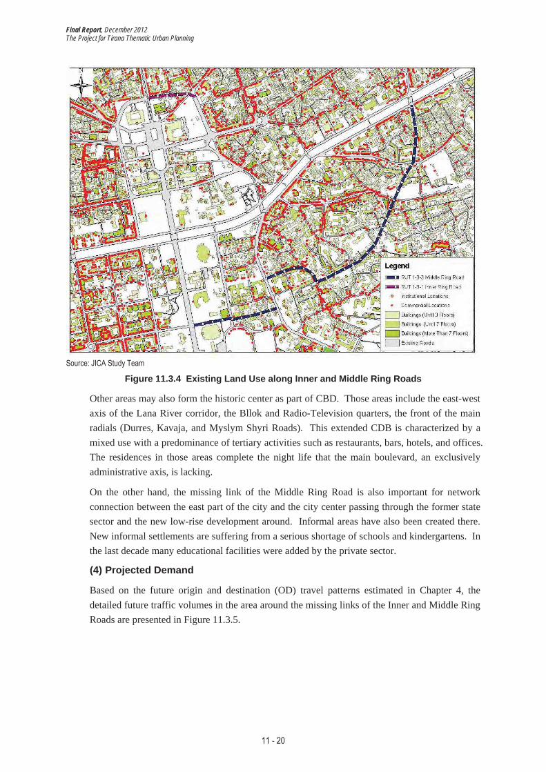
(3) Land Use
Existing land use along the Inner and Middle Ring corridors is shown in Figure 11.3.4. The Inner Ring Road serves as an important part of the city center network. The city center is defined by the boulevard which extends from the Polytechnic University in the south, through the central Skanderbeg Square to the railway station in the north. The city center comprises a distinct land use category due to its historical significance, representative civic design, and high mixture of uses, including administration and national capital functions. Open space, green areas, buildings for culture activities and offices, and few residential blocks are other important elements of the center.
Final Report, December 2012 The Project for Tirana Thematic Urban Planning
11 - 20
Source: JICA Study Team
Figure 11.3.4 Existing Land Use along Inner and Middle Ring Roads
Other areas may also form the historic center as part of CBD. Those areas include the east-west axis of the Lana River corridor, the Bllok and Radio-Television quarters, the front of the main radials (Durres, Kavaja, and Myslym Shyri Roads). This extended CDB is characterized by a mixed use with a predominance of tertiary activities such as restaurants, bars, hotels, and offices. The residences in those areas complete the night life that the main boulevard, an exclusively administrative axis, is lacking.
On the other hand, the missing link of the Middle Ring Road is also important for network connection between the east part of the city and the city center passing through the former state sector and the new low-rise development around. Informal areas have also been created there. New informal settlements are suffering from a serious shortage of schools and kindergartens. In the last decade many educational facilities were added by the private sector.
(4) Projected Demand
Based on the future origin and destination (OD) travel patterns estimated in Chapter 4, the detailed future traffic volumes in the area around the missing links of the Inner and Middle Ring Roads are presented in Figure 11.3.5.

Final Report, December 2012 The Project for Tirana Thematic Urban Planning
11 - 21
Note: Unit: 100 PCU per 3 hours (6:00-9:00 a.m.). Source: JICA Study Team
Figure 11.3.5 Traffic Volume Forecast around Inner and Middle Ring Project Roads (2027)
Particularly focusing on the project roads, present and future hourly traffic volumes and V/C ratios in the morning peak are summarized in Table 11.3.1. The missing link section of the Inner Ring Road will have a large traffic volume of 6,900 PCU per hour in the morning peak in future, and thus it should be developed as a primary (one-way) road with four lanes. Meanwhile, the peak-hour traffic demand forecast on the missing link section of the Middle Ring Road is approximately 2,400 to 3,100 PCU per hour in future; hence, development of a combination of a primary road and a secondary road in part should be sufficient.
Table 11.3.1 Present and Future Traffic Volume on Inner and Middle Ring Roads in the Morning Peak
Road Section Present Traffic Volume (2012) Future Traffic Volume (2027)
Missing Link of Inner Ring Road 800 PCU/hour, V/C = 0.29 (existing roads to be connected) 6,900 PCU/hour, V/C = 1.31
Missing Link of Middle Ring Road (Primary Road (H. Sufa Road) Section)
2,900 PCU/hour, V/C = 1.09 (existing roads to be connected) 2,500 PCU/hour, V/C = 0.48
Missing Link of Middle Ring Road (Secondary Road (Qemal Guranjaku Road) Section) 200 PCU/hour, V/C = 0.44 2,400 PCU/hour, V/C = 0.68
Missing Link of Middle Ring Road (Secondary Road (Asim Zeneli Road) Section)
200 PCU/hour, V/C = 0.26 (existing connecting road) 3,100 PCU/hour, V/C = 1.17
Source: JICA Study Team

Final Report, December 2012 The Project for Tirana Thematic Urban Planning
11 - 22
(5) Alternative Route Analysis 1) Inner Ring Road
In the MOT’s new plan, the Inner Ring Road missing link development is no longer included, and the existing roads are to be utilized to form a “twin rings” structure instead, as shown in Figure 11.3.6. However, the Inner Ring corridor is important to serve as a zone that is basically closed to private vehicles except for public transport as one of the important transportation control measures (TCMs).
Plan from MoTProposed by Study Team
Missing link
0 200m
Source: JICA Study Team
Figure 11.3.6 Comparison of Two Routes of Inner Ring Road
To analyze the benefit of developing the missing link, the above two alternative routes were tested for the future demand forecast. Results of the future demand forecasts are presented in Figure 11.3.7. In Alternative A, which includes development of the missing link as proposed by the Study team, there is no major traffic congestion observed around the Inner Ring Road though some roads inside the ring road are converted into pedestrian streets and thus are removed from the road network. On the other hand, in Alternative B, namely, the MOT’s new plan, considerable traffic congestion is observed on the Inner and Intermediate Ring Roads.

Final Report, December 2012 The Project for Tirana Thematic Urban Planning
11 - 23
[Alternative A: the Study team’s proposal] [Alternative B: the MOT’s new plan]
Note: Unit: PCU per 3 hours (6:00-9:00 a.m.). Based on the initially proposed road network. Source: JICA Study Team
Figure 11.3.7 Traffic Demand Forecast of Alternative Routes for Inner Ring Road (2027)
Development of the missing link may also be justified in terms of the economic feasibility. While the comprehensive economic analysis of each priority project is discussed in Section 11.5, result of an economic evaluation of the Inner Ring Road missing link construction project (RUT 1-3-1), of which project cost is estimated at around 627 million Lek, is presented in Table 11.3.2. The economic internal rate of return (EIRR), which is derived from the savings of the total travel time and vehicle operation cost, is approximately 92%. This is considered to fulfill the evaluation criteria of the EIRR (i.e., target of 10%) very well with a benefit-cost ratio is around 24.4.
Table 11.3.2 Economic Evaluation Results of Inner Ring Road Missing Link Project
EIRR B/C (discount rate: 10%)
92.1% 24.39 Source : JICA Study Team
2) Middle Ring Road
The south section of the Middle Ring Road is not continuous even in the old Regulatory Plan of 1989. As shown in Figure 11.3.8, in the MOT’s new plan, the road is taking a complex route which goes through the national park and a section of which traffic demand is estimated to be low except for some residential local traffic. Meanwhile, the Study team proposes completing the missing link as much as possible by utilizing the existing secondary road while detouring around the existing U.S. Embassy.

Final Report, December 2012 The Project for Tirana Thematic Urban Planning
11 - 24
Proposed by Study Team
(primary road)
U.S. Embassy
Very low demand
National Park
Plan from MoT
0 500m
Proposed by Study Team
(secondary road)
Proposed Tramline along
Lana River
Proposed by Study Team
(primary road)
Source: JICA Study Team
Figure 11.3.8 Comparison of Two Routes of Ring Road 3 (Middle Ring Road): South Section
Development of the route proposed by the Study team can also be justified in terms of its economic feasibility. Result of an economic evaluation of the Middle Ring Road missing link construction project (RUT 1-3-3), of which project cost is estimated at around 1.9 billion Lek, is presented in Table 11.3.3. The EIRR is approximately 33%, which is considered to fulfill the evaluation criteria of the EIRR, with a benefit-cost ratio of around 7.1.
Table 11.3.3 Economic Evaluation Results of Middle Ring Road Missing Link Project
EIRR B/C (discount rate: 10%)
32.7% 7.05 Source : JICA Study Team
11.3.3 Development Plan
(1) Inner Ring Road
Based on the above-mentioned future traffic demand, a four-lane primary road for the one-way (counterclockwise) direction is basically required for the missing link section of the Inner Ring Road (RUT 1-3-1) to meet the future traffic demand in 2027 from a viewpoint of design standard. In this context, a typical cross section is prepared as shown in Figure 11.3.9.

Final Report, December 2012 The Project for Tirana Thematic Urban Planning
11 - 25
Source: JICA Study Team
Figure 11.3.9 Typical Cross Section for Inner Ring Road Missing Link
(2) Middle Ring Road
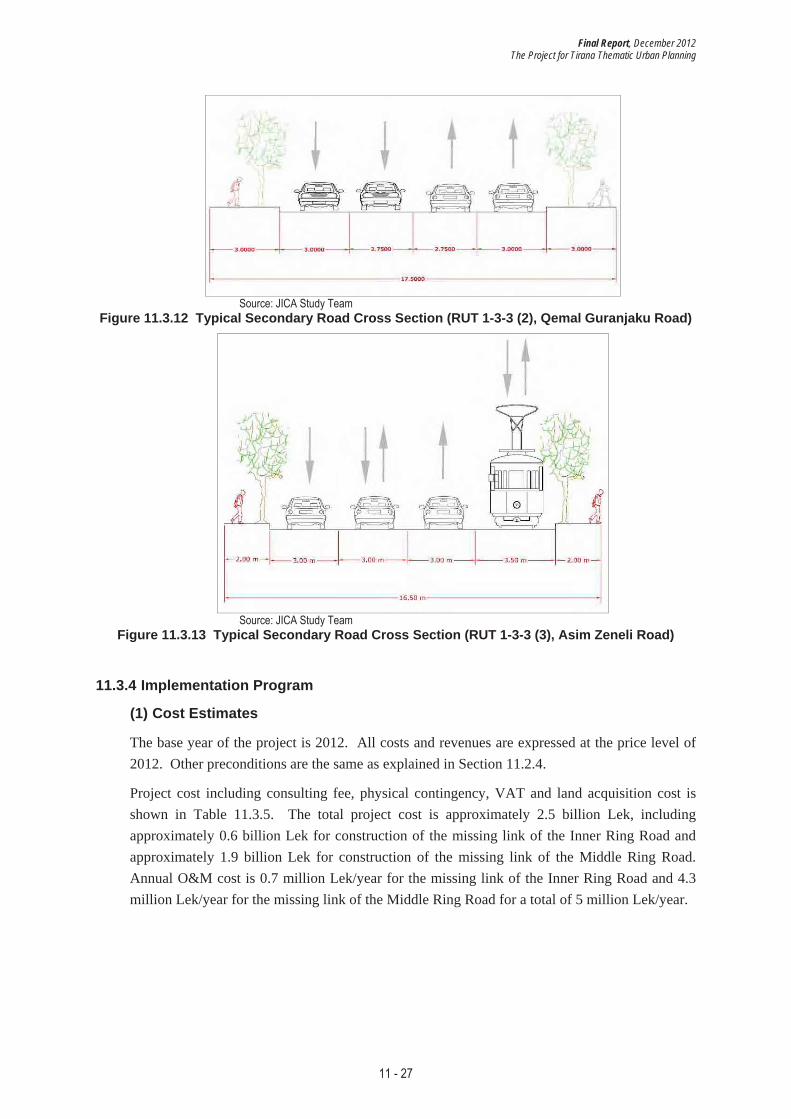
As for the missing link sections of the Middle Ring Road, a four-lane primary or secondary road for both directions is required to meet the future traffic demand in 2027, by each road sections as shown in Table 11.3.4. Locations of the following typical cross sections are shown in Figure 11.3.10 and the cross sections are presented in Figure 11.3.11, Figure 11.3.12, and Figure 11.3.13. Particularly on Asim Zeneli Road, one lane will be dedicated for the (single-tracked) tramline, while the remaining three traffic lanes will be utilized as a variable lane operation. That is, two traffic lanes will be used for the major traffic direction and the other one lane for the opposite direction, depending on the time periods. The center lane will be operated as a reversible lane.
Table 11.3.4 Development Road Sections for Middle Ring Road Missing Link Project
Section Road Class No. of Lanes
H. Sufa Road Primary road 4 traffic lanes
Qemal Guranjaku Road Secondary road 4 traffic lanes
Asim Zeneli Road Secondary road 3 traffic lanes and 1 tram lane Source : JICA Study Team

Final Report, December 2012 The Project for Tirana Thematic Urban Planning
11 - 26
Source: JICA Study Team Figure 11.3.10 Middle Ring Road Project (RUT 1-3-3) Location
Source: JICA Study Team Figure 11.3.11 Typical Primary Road Cross Section (RUT 1-3-3 (1), H. Sufa Road)
Final Report, December 2012 The Project for Tirana Thematic Urban Planning
11 - 27
Source: JICA Study Team Figure 11.3.12 Typical Secondary Road Cross Section (RUT 1-3-3 (2), Qemal Guranjaku Road)
Source: JICA Study Team Figure 11.3.13 Typical Secondary Road Cross Section (RUT 1-3-3 (3), Asim Zeneli Road)
11.3.4 Implementation Program
(1) Cost Estimates
The base year of the project is 2012. All costs and revenues are expressed at the price level of 2012. Other preconditions are the same as explained in Section 11.2.4.
Project cost including consulting fee, physical contingency, VAT and land acquisition cost is shown in Table 11.3.5. The total project cost is approximately 2.5 billion Lek, including approximately 0.6 billion Lek for construction of the missing link of the Inner Ring Road and approximately 1.9 billion Lek for construction of the missing link of the Middle Ring Road. Annual O&M cost is 0.7 million Lek/year for the missing link of the Inner Ring Road and 4.3 million Lek/year for the missing link of the Middle Ring Road for a total of 5 million Lek/year.

Final Report, December 2012 The Project for Tirana Thematic Urban Planning
11 - 28
Table 11.3.5 Project Cost: Priority Project 2 [Unit: million Lek]
Inner Ring Road (RUT 1-3-1)
Middle Ring Road (RUT 1-3-3) Total
Land* 443 981 1,423 Civil Works 121 693 815 Building 0 0 0 Machinery 0 0 0 Equipment 0 0 0 Sub-total 121 693 815 Consulting Service (5%) 5 29 34 VAT (20%) 21 121 143 Base Cost 128 728 855
Physical Contingency (10%) 13 73 86
Total 627 1,879 2,506 *Lland costs are not included for calculations of VAT, consulting service or physical contingency. Source: JICA Study Team
Resources from the MOT will be allocated for the required civil works, and resources from the Central Government will be allocated for land expropriation.
(2) Implementation Schedule 1) Implementation Schedule
The implementation schedule of Priority Project 2 is prepared in Table 11.3.6 considering the following aspects:
� It is better to avoid overlapping periods of the construction work sections to minimize the impact on the traffic during the construction; and
� Reconstruction of Asim Zeneli Road should also be completed before the development of the north-south tramline that is also planned as part of Priority Project 3 in this Study.
Preparation of the project, which includes basic and detail design and tendering, is scheduled for six months, followed by the main work of a total of three years (2013-2015).
Table 11.3.6 Implementation Schedule of Priority Project 2
New RoadSection
ReconstructionSection
2013 2014 2015 2016
Preparation
Inner Ring Road(Urani Pano Road)
130
Inner Ring Road 130
Middle Ring Road(H. Sufa Road)
854 300
Middle Ring Road(Qemal Guranjaku Road)
315
Middle Ring Road(Asim Zeneli Road)
454
Project Construction
Length (m) Year
Source: JICA Study Team

Final Report, December 2012 The Project for Tirana Thematic Urban Planning
11 - 29
2) Annual Cost Allocation
Total cost of Priority Project 2 amounts to 2.6 billion Lek in the period from 2013 to 2027, of which cost for investment is 2.5 billion Lek and that for O&M is 0.1 billion Lek. The annual cost schedule of Priority Project 2 based on the implementation schedule above is presented in Figure 11.3.14.
0
500
1,000
1,500
2,000
2,500
3,000
3,500
4,000
4,500
5,000
2013 2014 2015 2016 2017 2018 2019 2020 2021 2022 2023 2024 2025 2026 2027
Mill
ion
Lek
Construction Cost Land Acquisition Cost Operation & Maintenance Cost
Source: JICA Study Team Figure 11.3.14 Annual Allocation of Investment and O&M Cost of Priority Project 2 (2013-2027)

Final Report, December 2012 The Project for Tirana Thematic Urban Planning
11 - 30
11.4 Integrated Public Transport and Parking Development Project
There are three subprojects that are closely related to one another and thus need to be evaluated together as one project package.
11.4.1 Background and Objective
Under the current situation of a transportation system in Tirana that consists of bus transport and private vehicular traffic, the main objective of this Priority Project 3 is to establish a public transport network and to drastically improve the level of service by providing more parking facilities (RUT 2-3-1) and clearing on-street parking from the primary roads inside the CBD to secure enough space for ROW of a mass transit system such as tramlines (RUT 3-1-1 and 3-1-2) and dedicated bus lanes as a base of a BRT (bus rapid transit) (RUT 2-2-1), as shown in Figure 11.4.1. Furthermore, it aims to promote the usage of public transport through efficient TDM (transportation demand management) such as a parking pricing system (RUT 2-3-2).
Source: JICA Study Team Figure 11.4.1 Location of Priority Project 3 (RUT 2-2-1, 2-3-1, 3-1-1, 3-1-2)
The coverage area should be the whole Tirana metropolitan area including the MOT and the surrounding communes to enhance the convenience of public transport and promote the usage. For intermodality, Skanderbeg Square shall be designated as the main transfer nodes between the two tramlines as well as between connecting bus lines and the tramlines. As for transfer between private transport modes and the tramlines, terminals of Kinostudio, Kombinat, Intermodal Terminal, and Student City shall be designated as the major stations for Park & Ride system.

Final Report, December 2012 The Project for Tirana Thematic Urban Planning
11 - 31
11.4.2 Conditions of the Target Area
Present population and population density by transportation analysis zone (TAZ) in the Tirana metropolitan area is presented along with the public transport development corridors in Fugure 11.4.2. Population density along this project corridor is lower than other corridors supported by the west and south sections of the Outer Ring Road. This is partly attributable to lack of efficient transportation services in both road network and public transport network.
Tramlines (Plan)Dedicated Bus Lanes(Existing & Plan)
Source: JICA Study Team
Figure 11.4.2 Present Population and Population Density in Tirana by TAZ
(1) Land Use
In the aftermath of the socio-political and economic changes that happened in Albania in 1990, a great diversity of complex situations were created, bringing new conditions to date in relation to the following:
� Change in the property of land and restitution to the former owners,
� Decentralization of the economy, and
� Free movement of people.
The land use of Tirana today is a result of the above-mentioned processes and it is presented in Figure 11.4.3. In addition to the city center that was explained earlier in Section 11.3.2, the following are specially mentioned.

Final Report, December 2012 The Project for Tirana Thematic Urban Planning
11 - 32
1) Informal Areas
The uncontrolled migration has caused the sprawling of new settlements. More than two-thirds of the city was occupied by informal settlements. The lack of visions and planning policies, accompanied by the idea that everything is possible, as well as the failure of the State to catalogue and protect the cultural heritage, led to further demolition of the existing city, transforming the villas into high buildings.
2) Public Facilities
Near the Middle Ring Road, in the north of the historical center that includes many former state residential areas, there are many public facilities especially for education and health. Facilities for primary education are located throughout the residential areas; however, a much higher concentration is observed in the older neighborhoods than in the new ones.
Tramlines (Plan)Dedicated Bus Lanes(Existing & Plan)
Source: JICA Study Team
Figure 11.4.3 Existing Land Use in Tirana
(2) Projected Demand
Based on the future origin and destination (OD) travel patterns and the total trips to be shifted from private vehicles to public transport that are estimated in Chapter 4, the detailed future passenger volumes in the public transport network in Tirana are presented in Figure 11.4.4.

Final Report, December 2012 The Project for Tirana Thematic Urban Planning
11 - 33
Tramlines (Plan)Dedicated Bus Lanes(Existing & Plan)
Note: Unit: 100 PCU per 3 hours (6:00-9:00 a.m.). Source: JICA Study Team
Figure 11.4.4 Passenger Demand Forecast of the Transit Network (2027)
Particularly focusing on the major corridors of tramlines and dedicated bus lanes, present and future hourly passenger volumes in the morning peak are summarized in Table 11.4.1. A large increase in the number of passengers is expected in all these corridors. Among others, on the tramline corridors of Dibra Road, Kavaja Road, and Zogu I Boulevard, and on the dedicated bus lane corridor of Durres Road, over 10,000 passengers per hour will be added to each section in future; thus, the potential for a trunk mass transit corridor is very high.
On the other hand, on Elbasan Road and Asim Zeneli Road Sections of the north-south tramline, the projected number of passengers per hour is below 10,000. Therefore, a single track operation should be sufficient on the south end of this tramline (i.e., Mother Theresa Square – Student City) even in future.

Final Report, December 2012 The Project for Tirana Thematic Urban Planning
11 - 34
Table 11.4.1 Present and Future Sectional Passenger Volume on Major Tram and Bus Corridors in the Morning Peak
Section Present Passenger Volume (2012) Future Passenger Volume (2027) E-W Tramline (Kinostuidio – Kombinat) [RUT 3-1-1] (Dibra Road Section) 2,000 passengers/hour 12,100 passengers/hour
E-W Tramline (Kinostuidio – Kombinat) [RUT 3-1-1] (Kavaja Road Section*) 6,100 passengers/hour 21,900 passengers/hour
N-S Tramline (Student City – Intermodal Terminal) [RUT 3-1-2] (Zogu I Boulevard Section) 3,500 passengers/hour 19,600 passengers/hour
N-S Tramline (Student City – Intermodal Terminal) [RUT 3-1-2] (Elbasan Road & Asim Zeneli Road) 4,200 passengers/hour 8,300 passengers/hour
Dedicated Bus Lane [RUT 2-2-1] (Hoxha Tahsim & Xhanfize Keko Road) 2,500 passengers/hour 10,300 passengers/hour
Dedicated Bus Lane [RUT 2-2-1] (Komuna e Parisit Road) 700 passengers/hour 4,700 passengers/hour
Dedicated Bus Lane [RUT 2-2-1] (Durres Road) 3,700 passengers/hour 25,800 passengers/hour
Note: * Kavaja Road includes the section between Skanderbeg Square and the Outer Ring Road only. Source: JICA Study Team
11.4.3 Development Plan
For planning Priority Project 3, there are three subprojects, namely: (1) tramlines development, (2) dedicated bus lanes development, and (3) removal of on-street parking and supply of parking facilities along with parking pricing.
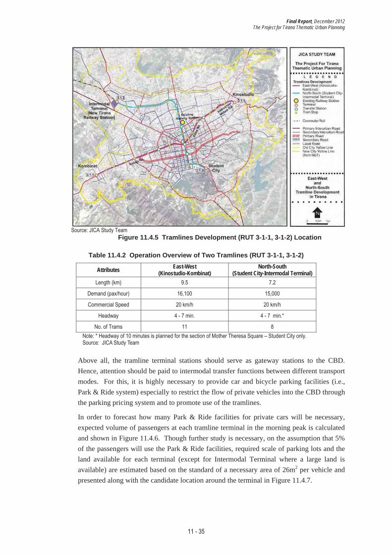
(1) Tramlines Development 1) Tramlines Development
The tramlines development projects and the related projects are presented in Figure 11.4.5. Two tramlines of east-west (RUT 3-1-1: Kinostudio-Kombinat) and north-south (RUT 3-1-2: Student City-Intermodal Terminal) lines are planned to serve as the core axes of the public transport network. Operation plans of these two tramlines are also summarized in Table 11.4.2. New, comfortable, safe, and air-conditioned trams will be operated at least at the same intervals as the currently operated bus lines, namely, 4-7 minutes to avoid long waiting time. Meanwhile, in the section of Mother Theresa Square – Student City of the north-south tramline, about 10-minute headway is planned based on the single-track operation. Assuming the commercial speed of about 20km/h, required size of the rolling stock is 11 trams for the east-west line and 8 trams for the north-south line. A common flat tariff of 60 Lek is also assumed with free transfers with buses.
Final Report, December 2012 The Project for Tirana Thematic Urban Planning
11 - 35
Source: JICA Study Team Figure 11.4.5 Tramlines Development (RUT 3-1-1, 3-1-2) Location
Table 11.4.2 Operation Overview of Two Tramlines (RUT 3-1-1, 3-1-2)
Attributes East-West(Kinostudio-Kombinat)
North-South(Student City-Intermodal Terminal)
Length (km) 9.5 7.2
Demand (pax/hour) 16,100 15,000
Commercial Speed 20 km/h 20 km/h
Headway 4 - 7 min. 4 - 7 min.*
No. of Trams 11 8 Note: * Headway of 10 minutes is planned for the section of Mother Theresa Square – Student City only. Source: JICA Study Team
Above all, the tramline terminal stations should serve as gateway stations to the CBD. Hence, attention should be paid to intermodal transfer functions between different transport modes. For this, it is highly necessary to provide car and bicycle parking facilities (i.e., Park & Ride system) especially to restrict the flow of private vehicles into the CBD through the parking pricing system and to promote use of the tramlines.
In order to forecast how many Park & Ride facilities for private cars will be necessary, expected volume of passengers at each tramline terminal in the morning peak is calculated and shown in Figure 11.4.6. Though further study is necessary, on the assumption that 5% of the passengers will use the Park & Ride facilities, required scale of parking lots and the land available for each terminal (except for Intermodal Terminal where a large land is available) are estimated based on the standard of a necessary area of 26m2 per vehicle and presented along with the candidate location around the terminal in Figure 11.4.7.

Final Report, December 2012 The Project for Tirana Thematic Urban Planning
11 - 36
1
21,000
14,00013,000
9,000
Note: Unit: passengers per 3 hours (6:00-9:00 a.m.). Source: JICA Study Team
Figure 11.4.6 Expected Number of Passengers at Each Tram Terminal (2027) [Kinostudio]
Required Land: 3,900 m2
Available Area: 6,000 m2
Number of floors: 3Parking slots: 450
Tram Terminal
[Kombinat] [Student City]
Required Land: 6,000 m2
Available Area: 13,000 m2
Number of floors: 3Parking slots: 700
Tram Terminal
Required Land: 5,600 m2
Available Area: 42,000 m2
Number of floors: 3Parking slots: 650
Tram Terminal
Note: Excluding Intermodal Terminal where a large land is available. Source: JICA Study Team
Figure 11.4.7 Candidate Park & Ride Facility Location at Each Tram Terminal
2) Radial Roads Development
In order to develop the above two tramlines, it is essential to secure the ROW of the

Final Report, December 2012 The Project for Tirana Thematic Urban Planning
11 - 37
tramlines while keeping the existing capacity of radial roads through reconstruction and road widening. Thus, projects for developing Dibra Road (RUT 1-4-1), Aleksander Moisiu Road (RUT 1-4-4), and Kavaja Road (RUT 1-4-7) have been included under the tramlines development subproject. Project road lengths, present and future hourly traffic volumes and V/C ratios in the morning peak, and result of an economic evaluation of these radial road development projects are summarized in Table 11.4.3. While EIRRs of all these projects fulfill the target rate of 10%, Priority Project 3 as a whole will generate much higher EIRR, bringing well enough net benefits to the Tirana metropolitan area, as described later in Section 11.5.2.
Table 11.4.3 Details and Quantitative Analyses of Road Projects for Tramlines Development
Road Projects New
Construction(km)
Reconstruction (km)
Present Traffic(2012)
Future Traffic (2027) EIRR
[RUT 1-4-1] Dibra Road - 1.26 1,400 PCU/hour
V/C = 1.47 2,000 PCU/hour
V/C = 0.37 19.7%
[RUT 1-4-4] Aleksander Moisiu Road - 0.92 900 PCU/hour
V/C = 0.60 2,400 PCU/hour
V/C = 0.45 17.4%
[RUT 1-4-7] Kavaja Road - 0.45 6,200 PCU/hour
V/C = 2.38 17,600 PCU/hour
V/C = 2.22 91.3%
Note: Traffic volumes are in the morning peak (6:00-9:00 a.m.). Source: JICA Study Team
3) Relocation of Tirana Railway Station
Furthermore, since there is no integrated intercity bus terminal yet in Tirana, integration of the intercity and international bus and van lines into one terminal with proper facilities is highly necessary. Thus, the new Intermodal Transportation Terminal should be developed in the location (approx. 85,000m2) where the existing Tirana railway station is to be relocated (RUT 3-3-1), as planned by the MOT. New Tirana railway station will be connected to the tramline and the intercity and city bus lines for smooth transfer. Therefore, this subproject also includes relocation of Tirana railway station along with removal of the railway tracks between the old and new stations only. Railway track to be demolished between old Tirana Station and new Tirana Station is about 4.3km.
(2) Dedicated Bus Lanes Development 1) Dedicated Bus Lanes Development
As shown in Figure 11.4.8, the current partial dedicated bus lanes will be extended more continuously on the urban primary roads to form a continuous, smooth network for buses, thereby serving as a bus rapid transit (BRT). Total length of the dedicated bus lanes to be developed is about 22.9km (RUT 2-2-1). It should be noted that the dedicated bus lane development is mainly for the line-haul type bus lines connecting the city center to the suburbs through the radial roads. By securing a relatively high operating speed, time schedule can also be foreseen, consequently reducing the waiting time and attracting more passengers.

Final Report, December 2012 The Project for Tirana Thematic Urban Planning
11 - 38
Source: JICA Study Team Figure 11.4.8 Dedicated Bus Lanes Development (RUT 2-2-1) Location
When the dedicated bus lanes and tramlines have been introduced as a core public transport system, the current bus route structure shall be redesigned in a hierarchical manner and in light of existing and future passenger demand patterns, as shown in Figure 11.4.9. A total of 11 existing bus lines will be restructured while 4 new bus lines will be introduced. Furthermore, new air-conditioned buses shall be invested to the restructured bus lines as presented in Table 11.4.4.

Final Report, December 2012 The Project for Tirana Thematic Urban Planning
11 - 39
Source: JICA Study Team Figure 11.4.9 Restructured City/Commune Bus Lines (RUT 3-2-1) Location
Table 11.4.4 Number of New Buses for Each Bus Line
Bus Line No. of Buses Bus Line No. of
Buses Bus Line No. of Buses
Kristal 13 Linza 10 Vora 19
Kopshti Zoologjik 12 Paskuqan 16 Tirana e Re � (30 old)
Lapraka 17 Porcelan � (10 old) Sauk-Ibe-Baldushk 10
(17 old)
Student City (new) 15 Kashar 14 Outer Ring (new) 35
Mihal Grameno (new) 9 Tufina � (6 old)
Opposite Tirana e Re (new) 23
Institut-Uzina Traktori 10 (25 old) Peza-Ndroq-Vaqarr 23
Source : JICA Study Team
The proposed bus lines are categorized into three types of bus services, namely, line-haul bus services, circulation bus services, and suburban feeder bus services. They will complement the core public transport system of the city, that is, the tramlines, serving the population of the entire Tirana metropolitan area, as shown in Figure 11.4.10.

Final Report, December 2012 The Project for Tirana Thematic Urban Planning
11 - 40
Line-Haul Bus Lines (7 lines)Circulation Bus Lines (3 lines)Feeder Bus Lines (7 lines)
Source: JICA Study Team Figure 11.4.10 Public Transport Network to Be Covered by Priority Project 3
2) Radial Roads Development
In order to develop the above dedicated bus lanes, it is essential to secure the ROW of the bus lanes while keeping the existing capacity of radial roads through reconstruction and road widening. Thus, projects for developing Hoxha Tahsim & Xhanfize Keko Road (RUT 1-4-2) and Komuna e Parisit & Medar Shtylla Road (RUT 1-4-3) have been included under the dedicated bus lanes development subproject. Project road lengths, present and future hourly traffic volumes and V/C ratios in the morning peak, and result of an economic evaluation of these radial road development projects are summarized in Table 11.4.5. While EIRRs of both projects fulfill the target rate of 10%, Priority Project 3 as a whole will generate a much higher EIRR, bringing well enough net benefits to the Tirana metropolitan area, as described later in Section 11.5.2.
Table 11.4.5 Details and Quantitative Analyses of Road Projects for Bus Lane Development
Road Projects New
Construction(km)
Reconstruction (km)
Present Traffic(2012)
Future Traffic (2027) EIRR
[RUT 1-4-2] Hoxha Tahsim & Xhanfize Keko Road
- 3.06 1,400 PCU/hour V/C = 1.45
3,100 PCU/hour V/C = 0.58 17.4%
[RUT 1-4-3] Komuna e Parisit & Medar Shtylla Road
0.60 1.06 1,300 PCU/hour V/C = 0.89
2,300 PCU/hour V/C = 0.44 23.2%
Note: Traffic volumes are in the morning peak (6:00-9:00 a.m.). Source: JICA Study Team

Final Report, December 2012 The Project for Tirana Thematic Urban Planning
11 - 41
(3) Removal of On-street Parking and Supply of Parking Facilities along with Parking Pricing 1) Parking System Development
For parking system development, first of all, additional parking facilities need to be developed in CBD to clear away the current on-street parking from the primary and secondary roads to secure the road space for public transport and bicycles while maintaining the same traffic capacity (RUT 2-3-1). This should be the very first step to take to realize the tramlines and dedicated bus lanes development under Priority Project 3. Particularly around the Inner Ring corridor area in which most of the roads are converted to be pedestrian streets, additional parking facilities are proposed mostly as underground parking, and the locations are presented in Figure 11.4.11.
Source: JICA Study Team Figure 11.4.11 Additional Parking Facilities in CBD (RUT 2-3-1) and Coverage Area
Furthermore, assuming the service coverage area from each parking location set as within 300 meters or a 5-minute walk, how much area inside the CBD is covered by parking facilities is also indicated in the same figure. Though the additional parking capacity of approximately 7,500 vehicles will well cover the number of on-street parking vehicles to be removed (i.e., approximately 3,200 vehicles), expansion of this coverage area remains an issue.
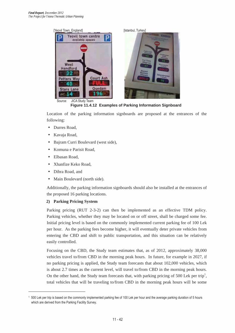
In RUT 2-3-1, a parking information system shall also be provided to smoothly guide car users to the most appropriate public and private parking lots along with parking availability information through information devices such as parking information signboards (Figure 11.4.12).
Final Report, December 2012 The Project for Tirana Thematic Urban Planning
11 - 42
[Yeovil Town, England] [Istanbul, Turkey]
Source: JICA Study Team Figure 11.4.12 Examples of Parking Information Signboard
Location of the parking information signboards are proposed at the entrances of the following:
� Durres Road,
� Kavaja Road,
� Bajram Curri Boulevard (west side),
� Komuna e Parisit Road,
� Elbasan Road,
� Xhanfize Keko Road,
� Dibra Road, and
� Main Boulevard (north side).
Additionally, the parking information signboards should also be installed at the entrances of the proposed 16 parking locations.
2) Parking Pricing System
Parking pricing (RUT 2-3-2) can then be implemented as an effective TDM policy. Parking vehicles, whether they may be located on or off street, shall be charged some fee. Initial pricing level is based on the commonly implemented current parking fee of 100 Lek per hour. As the parking fees become higher, it will eventually deter private vehicles from entering the CBD and shift to public transportation, and this situation can be relatively easily controlled.
Focusing on the CBD, the Study team estimates that, as of 2012, approximately 38,000 vehicles travel to/from CBD in the morning peak hours. In future, for example in 2027, if no parking pricing is applied, the Study team forecasts that about 102,000 vehicles, which is about 2.7 times as the current level, will travel to/from CBD in the morning peak hours. On the other hand, the Study team forecasts that, with parking pricing of 500 Lek per trip1,total vehicles that will be traveling to/from CBD in the morning peak hours will be some
1 500 Lek per trip is based on the commonly implemented parking fee of 100 Lek per hour and the average parking duration of 5 hours which are derived from the Parking Facility Survey.
Final Report, December 2012 The Project for Tirana Thematic Urban Planning
11 - 43
38,000 vehicles, which will keep more or less the same situation as the current level. Thus, parking pricing is extremely important to promote the use of public transport and to keep the total vehicular trips in the CBD as it is now.
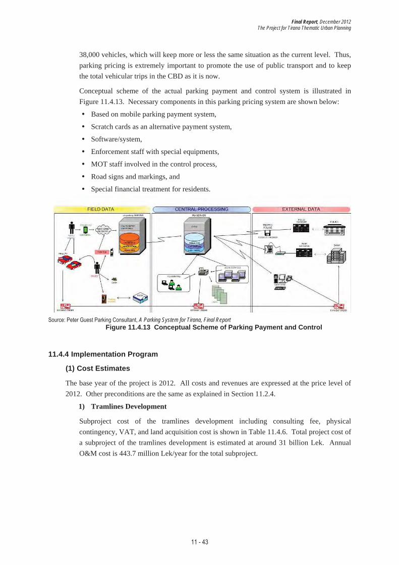
Conceptual scheme of the actual parking payment and control system is illustrated in Figure 11.4.13. Necessary components in this parking pricing system are shown below:
� Based on mobile parking payment system,
� Scratch cards as an alternative payment system,
� Software/system,
� Enforcement staff with special equipments,
� MOT staff involved in the control process,
� Road signs and markings, and
� Special financial treatment for residents.
Source: Peter Guest Parking Consultant, A Parking System for Tirana, Final Report Figure 11.4.13 Conceptual Scheme of Parking Payment and Control
11.4.4 Implementation Program
(1) Cost Estimates
The base year of the project is 2012. All costs and revenues are expressed at the price level of 2012. Other preconditions are the same as explained in Section 11.2.4.
1) Tramlines Development
Subproject cost of the tramlines development including consulting fee, physical contingency, VAT, and land acquisition cost is shown in Table 11.4.6. Total project cost of a subproject of the tramlines development is estimated at around 31 billion Lek. Annual O&M cost is 443.7 million Lek/year for the total subproject.

Final Report, December 2012 The Project for Tirana Thematic Urban Planning
11 - 44
Table 11.4.6 Project Cost: Subproject of Tramlines Development [Unit: million Lek]
East-WestTramline
(RUT 3-1-1)
North-SouthTramline
(RUT 3-1-2) Dibra Road (RUT 1-4-1)
Aleksander Moisiu Road (RUT 1-4-4)
Kavaja Road (RUT 1-4-7)
Relocation of Station
(RUT 3-3-1)
Sub-ProjectTotal
Land* 221 339 793 586 1,279 849 4,068 Civil Works 5,163 3,774 364 458 661 221 10,642 Building 1,666 2,017 0 0 0 978 4,661 Machinery 3,599 2,660 0 0 0 0 6,260 Equipment 950 720 0 0 0 16 1,685 Sub-total 11,378 9,171 364 458 661 1,215 23,247 Consulting Service (5%) 474 382 15 19 28 51 969 VAT (20%) 1,991 1,605 64 80 116 213 4,068 Base Cost 11,947 9,629 382 481 694 1,276 24,410 Physical Contingency (10%) 1,195 963 38 48 69 128 2,441
Total Investment 13,384 10,965 1,293 1,174 2,171 2,338 31,325 Annual O&M Cost 249.3 181.8 3.4 2.5 6.7 - 443.7
*Financial land costs are not included for calculations of VAT, consulting service or physical contingency. Source: JICA Study Team
Since the tramlines will be constructed either on the roads or on the existing railway tracks, no cost for land expropriation is assumed. Thus, the private sector is responsible for the initial investment including construction, signaling system, and rolling stock. O&M may be supported by the MOT or the central government (i.e., the public sector) as a subsidy.
As for the road development project, resources from the MOT will be allocated for the required civil works, and resources from the central government will be allocated for land expropriation. Meanwhile, the resources for the relocation of Tirana Railway Station will be from the central government or Albanian Railways (HSH).
2) Dedicated Bus Lanes Development
Subproject cost of the dedicated bus lanes development including consulting fee, physical contingency, VAT and land acquisition cost is shown in Table 11.4.7. Total project cost of a subproject of the dedicated bus lanes development is estimated at around 7 billion Lek. Annual O&M cost is 42.7 million Lek/year for the total subproject.

Final Report, December 2012 The Project for Tirana Thematic Urban Planning
11 - 45
Table 11.4.7 Project Cost: Subproject of Dedicated Bus Lanes Development [Unit: million Lek]
Dedicated Bus Lanes (RUT 2-2-1)
RestructuringBus Lines (RUT 3-2-1)
Hoxha Tahsim & Xhanfize Keko
Road (RUT 1-4-2)
Komuna e Parisit & Medar Shtylla
Road (RUT 1-4-3) Subproject
Total
Land* 0 0 1,081 176 1,257 Civil Works 602 0 1,256 117 1,974 Building 0 0 0 0 0 Machinery 0 3,234 0 0 3,234 Equipment 0 0 0 0 0 Sub-total 602 3,234 1,256 117 5,208 Consulting Service (5%) 25 135 52 5 217 VAT (20%) 105 566 220 20 911 Base Cost 632 3,395 1,318 123 5,468 Physical Contingency (10%) 63 340 132 12 547
Total Investment 695 3,735 2,640 328 7,398 Annual O&M Cost 30.1 - 8.2 4.4 42.7
*Financial land costs are not included for calculations of VAT, consulting service or physical contingency. Source: JICA Study Team
Since the dedicated bus lanes will be constructed on the roads, no cost for land expropriation is assumed. Thus, the private sector is responsible for the initial investment including new bus fleet. O&M may be supported by the MOT (i.e., the public sector) as a subsidy.
As for the road development project, resources from the MOT will be allocated for the required civil works, and resources from the central government will be allocated for land expropriation.
3) Removal of On-street Parking and Supply of Parking Facilities along with Parking Pricing
Subproject cost of the removal of on-street parking and the supply of parking facilities along with parking pricing including consulting fee, physical contingency, VAT and land acquisition cost is shown in Table 11.4.8. Total project cost of a subproject of removal of on-street parking and supply of parking facilities along with parking pricing is estimated at around 12 billion Lek. Annual O&M cost is 709.9 million Lek/year for the total subproject.

Final Report, December 2012 The Project for Tirana Thematic Urban Planning
11 - 46
Table 11.4.8 Project Cost: Subproject of Parking Development [Unit: million Lek]
Parking Facilities / Parking Information System (RUT 2-3-1)
Parking Pricing System
(RUT 2-3-2) Subproject
Total
Land* 0 0 0 Civil Works 3,172 0 3,172 Building 6,309 0 6,309 Machinery 0 73 73 Equipment 583 194 777 Sub-total 10,064 267 10,331 Consulting Service (5%) 419 11 430 VAT (20%) 1,761 47 1,808 Base Cost 10,567 280 10,848 Physical Contingency (10%) 1,057 28 1,085
Total Investment 11,624 309 11,933 Annual O&M Cost 496.4 213.5 709.9
*Financial land costs are not included for calculations of VAT, consulting service or physical contingency. Source: JICA Study Team
While the private sector is responsible for the investment for construction of the parking facilities, resources from the MOT will be allocated for the cost of the parking information system and the parking pricing system. It should also be noted that the parking pricing system is expected to bring about considerable revenue for other infrastructure investment.
The total cost of Priority Project 3 is approximately 51 billion Lek, including approximately 31 billion Lek for the tramlines development, 7 billion Lek for the dedicated bus lanes development, and 12 billion Lek for the parking development, as shown in Table 11.4.9. Annual O&M cost is 443.7 million Lek/year for the tramlines development, 42.7 million Lek/year for the dedicated bus lanes development, and 709.9 million Lek/year for the parking development, for a total of 1,196.3 million Lek/year.
Table 11.4.9 Project Cost: Priority Project 3 [Unit: million Lek]
Tramlines Development
Dedicated Bus Lanes
DevelopmentParking
Development Total
Land* 4,068 1,257 0 5,325 Civil Works 10,642 1,974 3,172 15,788 Building 4,661 0 6,309 10,970 Machinery 6,260 3,234 73 9,566 Equipment 1,685 0 777 2,462 Sub-total 23,247 5,208 10,331 38,787 Consulting Service (5%) 969 217 430 1,616 VAT (20%) 4,068 911 1,808 6,788 Base Cost 24,410 5,468 10,848 40,726 Physical Contingency (10%) 2,441 547 1,085 4,073
Total Investment 31,325 7,398 11,933 50,656 Annual O&M Cost 443.7 42.7 709.9 1,196.3
*Financial land costs are not included for calculations of VAT, consulting service or physical contingency. Source: JICA Study Team
Final Report, December 2012 The Project for Tirana Thematic Urban Planning
11 - 47
(2) Implementation Schedule 1) Implementation Schedule
The implementation schedule of Priority Project 3 is prepared in Table 11.4.10 considering the following aspects:
� The tramlines development should start with development of the relevant radial roads and relocation of Tirana railway station in order to secure enough space for construction of the tramlines; and
� The dedicated bus lanes development should start with development of the relevant radial roads in order to secure enough space for construction of the dedicated bus lanes. Since operation of some bus lines should start after the completion of the Outer Ring Road, it will be completed later than the other two subprojects.
It will take approximately 8 years (2013-2020) to complete all works of the components in the subproject for the tramlines development, 12 years (2013-2024) for the dedicated bus lanes development, and 9 years (2013-2021) for the removal of on-street parking and the supply of parking facilities along with parking pricing. Preparation of the project, which includes basic and detail design and tendering, is scheduled for six months to one year depending on each project component.

Final Report, December 2012 The Project for Tirana Thematic Urban Planning
11 - 48
Table 11.4.10 Implementation Schedule of Priority Project 3
2013 2014 2015 2016 2017 2018 2019 2020 2021 2022 2023 2024
RUT 3-1-1: East-West (Kinostudio-Kombinat) Tramline
RUT 3-1-2: North-South (Student City-Intermodal Terminal) Tramline
RUT 1-4-1: Dibra Road
RUT 1-4-4: Aleksander Moisiu Road
RUT 1-4-7: Kavaja Road
RUT 3-3-1: Relocation of Tirana Railway Station
RUT 2-2-1: Dedicated Bus LanesStage I: Durres, 29 Nentori, George W. Bush and Elbasan RoadsRUT 2-2-1: Dedicated Bus LanesStage II: Komuna e Parisit, Medar Shty lla and Tish Dahia RoadsRUT 2-2-1: Dedicated Bus LanesStage III: Hoxha Tahsim, Xhanfize Keko and Sotir Caci RoadsRUT 2-2-1: Dedicated Bus LanesStage IV: Ali Shefqeti RoadRUT 3-2-1: Restructuring Bus Lines, Stage I: Kristal, Kopshti Zoologjik,Lapraka, Student City , Mihal Grameno, Institut-Uzina TraktoriRUT 3-2-1: Restructuring Bus Lines, Stage II: Linza, Paskuqan,Porcelan, Kashar, Tufina, Peza-Ndroq-VaqarrRUT 3-2-1: Restructuring Bus Lines, Stage III: Vora, Tirana e Re,Sauk-Ibe-BaldushkRUT 3-2-1: Restructuring Bus Lines, Stage IV: Outer Ring, OppositeTirana e Re
RUT 1-4-2: Hoxha Tahsim & Xhanfize Keko Road
RUT 1-4-3: Komuna e Parisit & Medar Shty lla Road
RUT 2-3-1: Parking Facilities/Parking Information System
RUT 2-3-2: Parking Pricing System
Dedicated Bus Lanes Development
Parking Development
Tramlines Development
Year
Source: JICA Study Team
2) Annual Cost Allocation
Total cost of Priority Project 3 amounts to 62.7 billion Lek in the period from 2013 to 2027, of which cost for investment is 50.7 billion Lek and that for O&M is 12.0 billion Lek. The annual cost schedule of Priority Project 3 based on the implementation schedule above is presented in Figure 11.4.14.
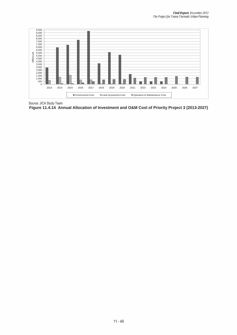
Final Report, December 2012 The Project for Tirana Thematic Urban Planning
11 - 49
0500
1,0001,5002,0002,5003,0003,5004,0004,5005,0005,5006,0006,5007,0007,5008,0008,5009,0009,500
2013 2014 2015 2016 2017 2018 2019 2020 2021 2022 2023 2024 2025 2026 2027
Milli
on L
ek
Construction Cost Land Acquisition Cost Operation & Maintenance Cost
Source: JICA Study Team Figure 11.4.14 Annual Allocation of Investment and O&M Cost of Priority Project 3 (2013-2027)
Final Report, December 2012 The Project for Tirana Thematic Urban Planning
11 - 50
11.5 Financial and Economic Analysis 11.5.1 Financial Analysis
Financial analysis of the two tramline development projects (East-West Line: RUT 3-1-1 and North-South Line: RUT 3-1-2) is carried out in this section by comparing respective financial costs and revenues of “With the Project” Case and “Without the Project” Case.
(1) Basic Assumptions
The following are the basic assumptions used for the financial analysis of the tramline development projects. It also applies to economic analysis of the three priority projects, unless otherwise mentioned.
1) Project Period
The project period is 30 years after the project completion, namely, from 2014 to 2047 (for RUT 3-1-1) and from 2017 to 2050 (for RUT 3-1-2). Construction period is from 2014 to 2017 (for RUT 3-1-1) and from 2017 to 2020 (for RUT 3-1-2).
2) Price Basis and Exchange Rate
The base year of the project is 2012. All costs and revenues are expressed at the price level of 2012. The Study assumes 3.0% annual inflation rate during the project life, which is the target inflation rate set by the Bank of Albania for 2012.
Exchange rates used are 1 Lek = 0.788 JP Yen = 0.007 Euro = 0.009 US Dollar, which are prevailing rates at the time of the Study.
3) Contingencies
Physical contingency of 10% is included in the analyses. The price contingency is not included.
4) Taxes
For the financial analysis, the 20%VAT is included while corporate tax is excluded.
5) Target Financial Internal Rate of Return (FIRR) on Project
The target FIRR of the projects varies depending on the investment share among different investors with different expected rate of return for the project.
As for the public investment, the target FIRR is set at 0%. That is to say, the public will receive revenue amount just enough to recover the investment costs.
It is assumed that the private investors, whether local or foreign, will avail themselves of bank loan to pay for the project. The prevailing long-term corporate lending rates in the local currency of commercial banks in Albania are in the range 13.0% at the time of the Study. The real interest rate is calculated at 9.7%, discounted by expected inflation rate of 3.0% for 2012 (1.13/1.03 (inflation rate) - 1 = 0.097). The local private investors’ target FIRR is set at 13.5% including loan administration costs, profit and risks.
Meanwhile, the target rate of foreign investors should be lower. Japanese investors, for example, should have access to loans with real interest rate of 1.55% or so. Thus, the target

Final Report, December 2012 The Project for Tirana Thematic Urban Planning
11 - 51
rate of foreign investors is assumed to be 7% in consideration of loan administration costs, profit and risks.
The share between the foreign and local private investors is set at 60% and 40%, respectively, based on the share of foreign and local investment amount of the project. The weighted average target FIRR for investors will be 9.6% if the projects are invested by private sector alone.
Table 11.5.1 Target FIRR by Investors
Public 0.0% Foreign Private Investor 7.0% Local Private Investor 13.5% Co-investment by private sector (Foreign Investors 60% and Local Private 40%) 9.6%
Source : JICA Study Team
(2) Financial Project Costs
The financial project costs are composed of investment costs and O&M (O&M) costs.
1) Investment Costs
Financial investment costs of the projects are calculated based on the total engineering investment costs as presented in previous sections.
Table 11.5.2 Financial Initial Investment Costs of Two Tramlines [Unit: million Lek]
East-West Line North-South Line Total
Land* 221 339 560
Civil Works 5,163 3,774 8,937
Building 1,666 2,017 3,683
Machinery 3,599 2,660 6,260
Equipment 950 720 1,669
Sub-total 11,378 9,171 20,549
Consulting Service (5%) 474 382 856 VAT (20%) 1,991 1,605 3,596 Base Cost 11,947 9,629 21,576
Physical Contingency (10%) 1,195 963 2,158
Total Financial Investment Costs 13,384 10,965 24,349 *Financial land costs are not included for calculations of VAT, consulting service or physical contingency. Source: JICA Study Team
There will be no replacement investment. The lifetime of invested assets is summarized below.
Table 11.5.3 Expected Lifetime of Assets for Financial Analysis Civil Works 50 years
Building 50 years Machinery and Equipment 30 years
Source: JICA Study Team
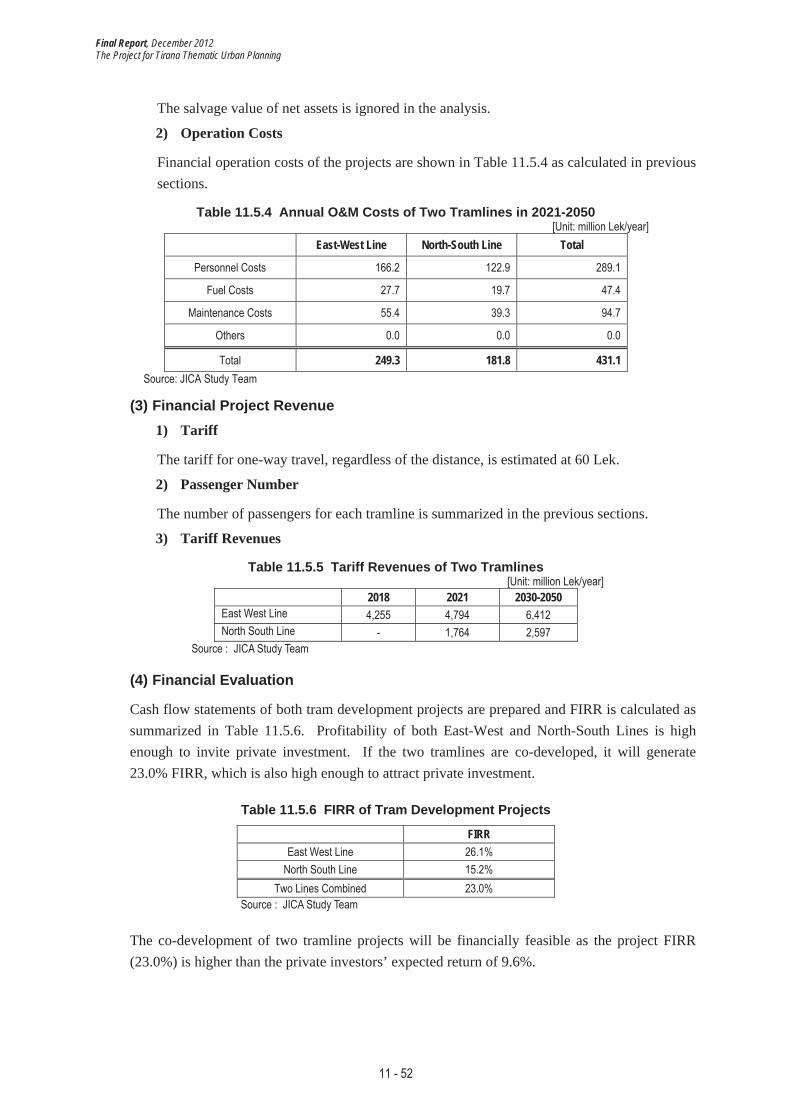
Final Report, December 2012 The Project for Tirana Thematic Urban Planning
11 - 52
The salvage value of net assets is ignored in the analysis.
2) Operation Costs
Financial operation costs of the projects are shown in Table 11.5.4 as calculated in previous sections.
Table 11.5.4 Annual O&M Costs of Two Tramlines in 2021-2050 [Unit: million Lek/year]
East-West Line North-South Line Total
Personnel Costs 166.2 122.9 289.1
Fuel Costs 27.7 19.7 47.4
Maintenance Costs 55.4 39.3 94.7
Others 0.0 0.0 0.0
Total 249.3 181.8 431.1 Source: JICA Study Team
(3) Financial Project Revenue 1) Tariff
The tariff for one-way travel, regardless of the distance, is estimated at 60 Lek.
2) Passenger Number
The number of passengers for each tramline is summarized in the previous sections.
3) Tariff Revenues
Table 11.5.5 Tariff Revenues of Two Tramlines [Unit: million Lek/year]
2018 2021 2030-2050 East West Line 4,255 4,794 6,412 North South Line - 1,764 2,597
Source : JICA Study Team
(4) Financial Evaluation
Cash flow statements of both tram development projects are prepared and FIRR is calculated as summarized in Table 11.5.6. Profitability of both East-West and North-South Lines is high enough to invite private investment. If the two tramlines are co-developed, it will generate 23.0% FIRR, which is also high enough to attract private investment.
Table 11.5.6 FIRR of Tram Development Projects
FIRREast West Line 26.1%
North South Line 15.2% Two Lines Combined 23.0%
Source : JICA Study Team
The co-development of two tramline projects will be financially feasible as the project FIRR (23.0%) is higher than the private investors’ expected return of 9.6%.

Final Report, December 2012 The Project for Tirana Thematic Urban Planning
11 - 53
Table 11.5.7 Financial Summary of Tram Development Projects [Unit: million Lek]
Initial Investment of Two Tramlines
Private Investment Project FIRR
Foreign Local ForeignShare
(%)
Local Share
(%)
Weighted Average
Target FIRR 24,349 14,610 9,740 60% 40% 9.6% 23.0%
Source: JICA Study Team
11.5.2 Economic Analysis
Economic analysis of the three Priority Projects is carried out in this section. The above analyzed two tramlines are part of Priority Project 3.
(1) Assumptions for Economic Analysis
In addition to the above mentioned basic assumptions for the financial analysis of tramlines, the following assumptions are applied to the economic analysis of the three priority projects.
1) Target Economic Internal Rate of Return (EIRR)
EIRR is an efficiency index for the use of scarce capital, indicating the average percentage of returns that can be expected every year to the national economy through the planned investment. International financial institutions such as World Bank apply 10% to 12% social discount rate in developing countries.
The project sets the target EIRR at 10%. That is to say, if the project’s EIRR is greater than 10%, the project is economically feasible and should bring net benefits to the regional economy.
2) Financial Project Costs
The financial project costs are composed of investment costs and O&M costs, which will be the basis for calculating economic project costs.
a) Financial Initial Investment Costs
Financial initial investment costs of the projects are calculated based on the total engineering investment costs as presented in previous sections.

Final Report, December 2012 The Project for Tirana Thematic Urban Planning
11 - 54
Table 11.5.8 Financial Initial Investment Costs of Three Priority Projects [Unit: million Lek]
PP1 PP2 PP3
Land* 7,378 1,423 5,325 Civil Works 8,821 815 15,788 Building 0 0 10,970 Machinery 0 0 9,566 Equipment 0 0 2,462 Sub-total 8,821 815 38,787 Consulting Service (5%) 368 34 1,616 VAT (20%) 1,544 143 6,788 Base Cost 9,262 855 40,726
Physical Contingency (10%) 926 86 4,073
Total 18,304 2,506 50,656 *Financial land costs are not included for calculations of VAT, consulting service or physical contingency. Source: JICA Study Team
There will be no replacement investment. The lifetime of invested assets is summarized below.
Table 11.5.9 Expected Lifetime of Assets for Economic Analysis Civil Works 50 years
Building 50 years Machinery and Equipment 30 years
Source: JICA Study Team
The salvage value of net assets is ignored in the analysis.
b) Financial Operation Costs
Financial operation costs of the projects are shown in Table 11.5.10 as calculated in previous sections.
Table 11.5.10 Annual O&M Costs of Three Priority Projects in 2021-2050 [Unit: million Lek/year]
PP1 PP2 PP3
Personnel Costs 0.0 0.0 541.2
Utility Costs 0.0 0.0 247.2
Fuel Costs 0.0 0.0 94.7
Maintenance Costs 38.7 5.0 313.2
Others 0.0 0.0 0.0
Total 38.7 5.0 1,196.3 Source: JICA Study Team
3) Economic Project Costs
In principle, economic project costs are to exclude fiscal distortions such as taxes, and subsidies. Economic project costs are calculated by excluding the 20% VAT from the above financial project costs.

Final Report, December 2012 The Project for Tirana Thematic Urban Planning
11 - 55
4) Economic Benefits
The study considers reduction in travel time and travel costs for passengers of both road and public (i.e., trams and buses) transportation between “With the Project” Case and “Without the Project” Case as economic benefit items of each priority project.
Benefit amount of each economic benefit item for each priority project is calculated using the following basic units.
a) Reduction in Travel Time Value
� Road Transportation
The basic units of vehicle operating time value are summarized in Table 11.5.11. The original data is taken from the Japanese Ministry of Land, Infrastructure, Transport and Tourism (MLIT)2 and is adjusted to Albanian price according to GDP per capita in PPP (power purchasing parities)3 of the two countries.
Table 11.5.11 Basic Units of Vehicle Operating Time Value in Albania in 2012 [Lek/minute/vehicle]
Passenger Car 13.5 Bus 125.8
Small Trucks 16.1 Regular Trucks 21.6
Source: MLIT and JICA Study Team
� Public Transportation
Travel time using public transportation is converted to time value using GDP per capita/hour (147 Lek) as calculated in Table 11.5.12.
Table 11.5.12 Basic Units of Travel Time Value in Albania in 2012 [Unit: Lek]
(1)GDP per capita 435,240 Lek*
(2)Estimated Annual Working Hours 1,926 hours
(3)GDP per capita/hour
(4) At work ((1)/(2)) 226
(5)At other-than Work (30% x (4)) 68
(6)Weighted average GDP/capita/hour** 147
*It is converted to Lek from US$4,030 (source: the World Bank) **Share of ‘At Work’ and ‘At other-than Work’ is estimated at 50 to 50. Source: The World Bank and JICA Study Team
2 http://www.mlit.go.jp/road/ir/ir-council/hyouka-syuhou/4pdf/s1.pdf 3 Source: The World Bank

Final Report, December 2012 The Project for Tirana Thematic Urban Planning
11 - 56
b) Reduction in Travel Costs
� Road Transportation
The following table summarizes the basic units of vehicle operating costs on regular roads in city area. The original data is taken from the MLIT and is adjusted to Albanian price according to GDP in PPP4 of the two countries.
Table 11.5.13 Basic Units of Vehicle Operating Costs in Albania in 2012 [Unit: Lek/km]
km/hour Passenger Car Bus Small Trucks Regular Trucks 5 23.43 59.84 17.99 40.75
10 17.01 50.41 15.38 33.45 15 14.78 46.75 14.28 29.92 20 13.60 44.60 13.59 27.47 25 12.86 43.11 13.09 25.55 30 12.35 41.99 12.68 23.97 35 11.97 41.13 12.36 22.66 40 11.83 40.66 12.18 21.86 45 11.74 40.32 12.04 21.24 50 11.70 40.11 11.95 20.80 55 11.70 40.01 11.89 20.55 60 11.73 40.03 11.89 20.48
Source: MLIT and JICA Study Team
� Public Transportation
Public transportation tariff is used as travel costs for passengers. VAT included in the tariff is not excluded from the analysis as it is the costs (minus benefits) for passengers.
(2) Economic Evaluation
Economic cash flow of the three Priority Projects is prepared based on the above assumptions, and EIRR is calculated as summarized in Table 11.5.14. EIRR of all three priority projects is above the target rate of 10%. It therefore could be concluded that all three priority projects should bring sufficient net economic benefits to the region.
Table 11.5.14 EIRR Summary of Three Priority Projects in Road and Urban Transport Sector EIRR
PP 1 52.1% PP 2 29.3% PP 3 16.8%
Source : JICA Study Team
11.5.3 Conclusion
The two tramlines development project will generate sufficient profits for the private investment. Meanwhile, EIRR of all three priority projects is above the target rate of 10%. They will all bring sufficient net economic benefits to the region.
Given the above, it is concluded that all three Priority Projects should be implemented.
4 Source: The World Bank

Final Report, December 2012 The Project for Tirana Thematic Urban Planning
11 - 57
11.6 Environmental Considerations 11.6.1 Scoping of Proposed Action Plans / Projects
In the road and urban transportation sector, the following four major development plans are studied:
� Development of Outer Ring Road (northern section),
� Development of Inner / Middle Ring missing links,
� Development of tramlines and dedicated bus lanes,
� Development of radial roads for tramlines and dedicated bus lanes, and
� Development of parking systems.
Those major projects with the priority of implementation and facility development which may cause adverse impacts on the environment have been selected for the environmental and social consideration (ESC).
(1) Development of Outer Ring Road (Northern Section) 1) Alternatives Considered
Four (4) options (O1, O 2, O3 and Zero Option) on the route plans in the northern section including zero option (“do nothing”) are shown in Table 11.6.1.
The proposed plan is to develop a road section running parallel to the Tirana River, a natural river, and has four options including zero option of 1) O1: an option to develop a new road in the south part of the Tirana River, 2) O2: an option to develop a new road in the both sides of the Tirana River along with the development recreation park and 3) O3: an option to develop a ring road through utilizing an existing road in the northern parts along the Tirana River (proposed by the Study team). The location of the proposed project is shown in Figure 11.6.1.
Table 11.6.1 Alternatives in Northern Section of Outer Ring Road South Route
(O1)Routes in Both Sides of
Tirana River (O2)
North Route (O3) Zero Option
Outlin
e of A
ltern
ative
s
The planned route is based on the Regulatory Plan which was proposed in 1990 and in 2008, which starts at the crossing point to the national road (Arber Road), runs in the south part parallel to Tirana River and finally terminates at the completed section of the ring road.
The route plan is currently proposed by Ministry of Transport & Public Works, which starts at the crossing point to the national road (Arber Road), runs by one way in both parts parallel to Tirana River, connects to the completed section of the ring road and the existing national road to Shkodra together with the development of recreational park at the river banks. The site is not high in terms of degree of vegetation and shows only a humble cityscape.
The route plan starts at the crossing point to the national road (Arber Road), crosses Tirana River, runs in its north parts parallel to it by utilizing the existing road (Paskuqan Road), finally terminates at the completed section of the ring road and connects with the national road in the direction of Shkodra.
Any ring road is not developed in the north part of the city and only the completed section and the section currently under construction are left.
Source : JICA Study Team

Final Report, December 2012 The Project for Tirana Thematic Urban Planning
11 - 58
2) Possible Environmental and Social Impacts
The country has nearly 350,000 informal properties spread in 320,000 ha. Particularly, in the north part of the city, plenty of rural residents have migrated to the area along the Tirana River through occupying the lands and building their houses without any permission or any plan of MOT or central government after 1990 when the communism ended. For such historical background, the social infrastructure such as paved roads with enough width or sewer lines has not fully been developed. Furthermore, garbage and domestic wastewater / sewage were dumped or directly discharged into the river without any treatment, respectively. The target area, accordingly, has been deteriorated in sanitary condition with dumped garbage and river water environment with direct discharge of sewage, and its scenic value has also deteriorated.
The results of estimated environmental and social impacts are shown in Table 11.6.2. Any development option except for zero option may require land acquisition for securing ROW of the project sites and result in an expropriation or resettlement of residential houses and establishments. The development of new roads in case of O1, O2 and O3 may generate air pollutants and noise during construction and operation stages although the zero option may also cause air pollution due to the traffic congestion for future increased traffic demand.

Final Report, December 2012 The Project for Tirana Thematic Urban Planning
11 - 59
Table 11.6.2 Scoping Results: Outer Ring Road Alternatives Considered
Element to be assessed
South Route (O1)
Route Plan of Both Sided of Tirana River
(O2)
North Route (O3) Zero Option
1 2 3 1 2 3 1 2 3 1 2 3
1. So
cio E
nviro
nmen
t
1.1 Land Issue / Resettlement A A N A A N A A N C C C 1.2 Local Economy & Livelihood N N N N N N N N N C C C 1.3 Land Use and Use of Local Resources C C C C C C C C C C C C
1.4 Split of Communities C C C C C C C C C C C C 1.5 Social Infrastructure B B N B B N B B N C C C 1.6 Vulnerable or Ethnic Minorities B B N B B N B B N C C C 1.7 Cultural Heritage C C C C C C C C C C C C 1.8 Local Conflicts N N N N N N N N N N N N 1.9 Water Use or Water Rights C C C C C C C C C C C C 1.10 Public Health incl. HIV/AIDS C B N C B N C B N A A A 1.11 Hazards C B C C B C C B C C C C
2. Na
tural
Envir
onme
nt
2.1 Topography and Geography C C C C B C C C C C C C 2.2 Groundwater C C C C C C C C C C C C 2.3 Soil Erosion C C C C C C C C C C C C 2.4 Hydrological Situation C C C C B B C C C C C C 2.5 Coastal Environment C C C C C C C C C C C C 2.6 Flora & Fauna C C C C C C C C C C C C 2.7 Meteorology C C C C C C C C C C C C 2.8 Scenic Value or Cityscape C B B C B B C B B B B B 2.9 Global Warming C C B C C B C C B C C C
3. Po
llutio
n
3.1 Air Pollution C B A C B A C B A C C A 3.2 Water Pollution C B C C B C C B C B B B 3.3 Soil Contamination C C C C C C C C C C C C 3.4 Solid Waste C B C C B C C B C A A A 3.5 Noise & Vibration C B C C B B C B B C C C 3.6 Ground Subsidence C C C C C C C C C C C C 3.7 Offensive Odor C C C C C C C C C A A A 3.8 River Sediment C C C C B C C C C C C C 3.9 Radio Wave Interference C C C C C C C C C C C C 3.10 Obstruction of Sunshine C C C C C C C C C C C C
Notes; 1) Stage of Project Activity 1: Before Construction, 2: During Construction, 3: During Operation 2) Impact Level
Negative Impact; A: Serious, B: Some, C: Negligible Positive Impact: ++ N: Level of impact is unknown.
Source: JICA Study Team
(2) Development of Inner / Middle Ring Missing Links 1) Alternatives Considered
A new road development for the Inner Ring Road is proposed at the site of the extended road of about 260 m between Barricades Road and Zogu I Boulevard behind Tirana International Hotel, which is currently a roundabout section and poses inconvenience for urban traffic. A new road development for Middle Ring Road is also proposed in the south-east part of Tirana city (Brryli District – Pjeter Budi Road) in an extended distance of about 1km.
The planned routes of above roads were already decided in the old Regulatory Plan in 1989 and they are also covered in the “Municipal Roads Sustainable Transport Strategy” in 2009. Therefore, no other alternatives are taken into consideration for ESC.

Final Report, December 2012 The Project for Tirana Thematic Urban Planning
11 - 60
A summary of the planning condition and current state of the surrounding environmental and social conditions is shown in Table 11.6.3.
Table 11.6.3 Planning Condition and Surrounding Environment (Inner / Middle Ring Road) Inner Ring Road Middle Ring Road
Outlin
e of P
ropo
sed
Plan
� Development of new road: Approximately 100 m � Location: Behind Tirana International Hotel � Road section: Barricades Road - Zogu I Boulevard � Surrounding land use: Residential houses
(apartments), offices � Flora & Fauna: The site is already urbanized. No
protection area for ecosystem � Cultural heritage: No protected cultural nor historical
sites
� Development of new road: Approximately 1km � Location: South-east part of Tirana city � Road section: Brryli District – Budi Road � Surrounding land use: Residential houses, school,
offices � Flora & Fauna: The site is already urbanized. No
protection area for ecosystem � Cultural heritage: No protected cultural nor historical
sites Source : JICA Study Team
2) Possible Environmental and Social Impacts
The results of estimated environmental and social impacts are shown in Table 11.6.4. The proposed project of the Inner and Middle Ring Roads is a new road development in the city center which has already been urbanized and may cross over several apartments and offices. Therefore, the residents’ and office owners’ properties that are possibly affected by the proposed projects will have to be expropriated and/or the owners/residents resettled. The proposed projects may generate noise and air pollutants during the construction and operation stages, and may cause some change of cityscape at the same time.
On one hand, the development of Middle Ring Road may also cause similar impacts in the same manner as mentioned in the development of the Inner Ring Road. However, the scale of resettlement of residential houses and offices will be more significant compared to those of the Inner Ring Road.

Final Report, December 2012 The Project for Tirana Thematic Urban Planning
11 - 61
Table 11.6.4 Scoping Results: Development of Inner / Middle Ring Roads Development Plan
Element to be assessed
Inner Ring Road Middle Ring Road 1 2 3 1 2 3
1. So
cio E
nviro
nmen
t
1.1 Involuntary Resettlement A A C A A C 1.2 Local Economy & Livelihood N N N N N N 1.3 Land Use and Use of Local Resources C C C C C C 1.4 Split of Communities C C C C C C 1.5 Social Infrastructure C B C C B C 1.6 Vulnerable or Ethnic Minorities C C C C C C 1.7 Cultural Heritage C C C C C C 1.8 Local Conflicts C C C C C C 1.9 Water Use or Water Rights C C C C C C 1.10 Public Health incl. HIV/AIDS C C C C C C 1.11 Hazards C B C C B C
2. Na
tural
Envir
onme
nt
2.1 Topography and Geography C C C C C C 2.2 Groundwater C C C C C C 2.3 Soil Erosion C C C C C C 2.4 Hydrological Situation C C C C C C 2.5 Coastal Environment C C C C C C 2.6 Flora & Fauna C C C C C C 2.7 Meteorology C C C C C C 2.8 Scenic Value or Cityscape C B B C B B 2.9 Global Warming C C C C C C
3. Po
llutio
n
3.1 Air Pollution C B B C B A 3.2 Water Pollution C C C C C C 3.3 Soil Contamination C C C C C C 3.4 Solid Waste C B C C B C 3.5 Noise & Vibration C B B C B B 3.6 Ground Subsidence C C C C C C 3.7 Offensive Odor C C C C C C 3.8 River Sediment C C C C C C 3.9 Radio Wave Interference C C C C C C 3.10 Obstruction of Sunshine C C C C C C
Notes; 1) Stage of Project Activity 1: Before Construction, 2: During Construction, 3: During Operation 2) Impact Level
Negative Impact; A: Serious, B: Some, C: Negligible Positive Impact: ++ N: Level of impact is unknown.
Source: JICA Study Team
(3) Development of Tramlines and Dedicated Bus Lanes 1) Alternatives Considered
In Tirana city, its citizen’s dependence on public transport system is 36% (27% use private automobiles), which is much higher compared to other nations such as those in south-east Asia (e.g., 17%, in the case of Malaysia). In addition, development of a public transport system will have an important significance in the sense that the number of vehicles entering the city center will be controlled. Two tramlines (LRT system) are proposed on existing road areas. One is the east-west line (Kinostudio – Kombinat) and another is the north-south line (Student City –Intermodal Terminal).
Meanwhile, the current partial dedicated bus lanes are proposed to be extended more continuously on the urban primary roads to form a continuous, smooth network for buses, thereby serving as a BRT. There is no alternative for the proposed plan.

Final Report, December 2012 The Project for Tirana Thematic Urban Planning
11 - 62
2) Possible Environmental and Social Impacts
The results of estimated environmental and social impacts caused by the tramlines development in addition to zero option (“do nothing”) are shown in Table 11.6.5. The proposed plan may require additional investment of station, rail track, tram and signal systems. The tramlines development plan may not cause an adverse impact on land issue such as land acquisition nor resettlement. The proposed plan may cause some impacts on the social infrastructure (traffic flow) and hazard (traffic accidents) during the construction stage (installation of railway tracks and aerial wirings). However, some positive impact on air environment and global warming are estimated during its operation stage compared to zero option because it will increase the number of vehicles.
Table 11.6.5 Scoping Results: Tramlines Development Alternatives Considered
Element to be assessed Tramlines Development Zero Option
1 2 3 1 2 3
1. So
cio E
nviro
nmen
t
1.1 Land Issue / Resettlement C C C C C C 1.2 Local Economy & Livelihood N N N N N N 1.3 Land Use and Use of Local Resources C C C C C C 1.4 Split of Communities C C C C C C 1.5 Social Infrastructure C B C C C C 1.6 Vulnerable or Ethnic Minorities C C C C C C 1.7 Cultural Heritage C C C C C C 1.8 Local Conflicts C C C C C C 1.9 Water Use or Water Rights C C C C C C 1.10 Public Health incl. HIV/AIDS C C C C C C 1.11 Hazards C B B C C C
2. Na
tural
Envir
onme
nt
2.1 Topography and Geography C C C C C C 2.2 Groundwater C C C C C C 2.3 Soil Erosion C C C C C C 2.4 Hydrological Situation C C C C C C 2.5 Coastal Environment C C C C C C 2.6 Flora & Fauna C C C C C C 2.7 Meteorology C C C C C C 2.8 Scenic Value or Cityscape C C C C C C 2.9 Global Warming C C ++ C C B
3. Po
llutio
n
3.1 Air Pollution C C ++ C C B 3.2 Water Pollution C C C C C C 3.3 Soil Contamination C C C C C C 3.4 Solid Waste C C C C C C 3.5 Noise & Vibration C B B C C B 3.6 Ground Subsidence C C C C C C 3.7 Offensive Odor C C C C C C 3.8 River Sediment C C C C C C 3.9 Radio Wave Interference C C C C C C 3.10 Obstruction of Sunshine C C C C C C
Notes; 1) Stage of Project Activity 1: Before Construction, 2: During Construction, 3: During Operation 2) Impact Level
Negative Impact; A: Serious, B: Some, C: Negligible Positive Impact: ++ N: Level of impact is unknown.
Source: JICA Study Team
On the other hand, the results of estimated environmental and social impacts caused by the dedicated bus lanes development are shown in Table 11.6.6. The dedicated bus lanes development project may cause adverse impact on air pollution although this development will not require resettlement because it is planned in the existing road area. BRT system

Final Report, December 2012 The Project for Tirana Thematic Urban Planning
11 - 63
may require a measure for controlling and reducing air pollutants to be generated at the operation. This development may not cause an adverse impact on land issue such as land acquisition nor resettlement, but it may cause some impacts on the existing road system and hazard such as traffic accidents during the construction stage.
Table 11.6.6 Scoping Results: Development of Dedicated Bus Lanes Alternative Considered
Element to be assessed
Development of Dedicated Bus Lanes1 2 3
1. So
cio E
nviro
nmen
t
1.1 Land Issue / Resettlement C C C 1.2 Local Economy & Livelihood N N N 1.3 Land Use and Use of Local Resources C C C 1.4 Split of Communities C C C 1.5 Social Infrastructure C B ++ 1.6 Vulnerable or Ethnic Minorities C C C 1.7 Cultural Heritage C C C 1.8 Local Conflicts C C C 1.9 Water Use or Water Rights C C C 1.10 Public Health incl. HIV/AIDS C C C 1.11 Hazards C B B
2. Na
tural
Envir
onme
nt
2.1 Topography and Geography C C C 2.2 Groundwater C C C 2.3 Soil Erosion C C C 2.4 Hydrological Situation C C C 2.5 Coastal Environment C C C 2.6 Flora & Fauna C C C 2.7 Meteorology C C C 2.8 Scenic Value or Cityscape C B C 2.9 Global Warming C C B
3. Po
llutio
n
3.1 Air Pollution C B A 3.2 Water Pollution C C B 3.3 Soil Contamination C C C 3.4 Solid Waste C B C 3.5 Noise & Vibration C C B 3.6 Ground Subsidence C C C 3.7 Offensive Odor C C C 3.8 River Sediment C C C 3.9 Radio Wave Interference C C C 3.10 Obstruction of Sunshine C C C
Notes; 1) Stage of Project Activity 1: Before Construction, 2: During Construction, 3: During Operation 2) Impact Level
Negative Impact; A: Serious, B: Some, C: Negligible Positive Impact: ++ N: Level of impact is unknown.
Source: JICA Study Team
(4) Development of Radial Roads for Tramlines and Dedicated Bus Lanes 1) Alternatives Considered
The development of radial roads involves widening existing roads in the city center in order to secure the ROW for the tramlines and dedicated bus lanes development. The following four routes are proposed as priority projects.
� Intersection of Barricades and Dibra road – Intersection of Bardhyl and Dibra road (R1)for tramline development: About 1.3 km

Final Report, December 2012 The Project for Tirana Thematic Urban Planning
11 - 64
� Sheshi Sulejman Pasha – Intersection of Xhanfize Keko and Aleksander Moisiu road (near Hygiene Institute) (R2) for dedicated bus lane development: About 3.3km
� Komuna e Parisit road (Lana River – Outer Ring Road) (R3) for dedicated bus lane development: About 1.2km
� Aleksander Moisiu road (R4) for tramline development: About 1km
The above developments are planned in existing roads and the development concept of the road was studied in the Regulatory Plan in 1989. Therefore, no other alternatives are taken into consideration for ESC. The location of the proposed project is shown in Figure 11.6.1.
A summary of the planning condition and current state of surrounding environmental and social conditions are shown in Table 11.6.7.
Table 11.6.7 Planning Condition and Surrounding Environment (Radial Roads) R1 R2 R3 R4
Outlin
e of P
ropo
sed P
lan
� Widening of existing road: About 1.3 km
� Road section: Intersection of Barricades and Dibra road – Intersection of Bardhul and Dibra road
� Surrounding land use: existing road area, offices, residential houses, shops
� Flora & Fauna: The site is already urbanized. No protection area for ecosystem
� Cultural heritage: No protected cultural nor historical sites
� Widening of existing road: About 3.3 km
� Road section: Sulejman Pasha – Intersection of Xhanfize Keko and Aleksander Moisiu road
� Surrounding land use: existing road area, offices, residential houses, shops
� Flora & Fauna: The site is already urbanized. No protection area for ecosystem
� Cultural heritage: No protected cultural nor historical sites
� Widening of existing road: About 1.2 km
� Road section: Komuna e Parisit road � Surrounding land use:
existing road area, offices, residential houses, shops
� Flora & Fauna: The site is already urbanized. No protection area for ecosystem
� Cultural heritage: No protected cultural nor historical sites
� Widening of existing road: About 1 km
� Road section: Aleksander Moisiu road � Surrounding land use:
existing road area, offices, residential houses, shops
� Flora & Fauna: The site is already urbanized. No protection area for ecosystem
� Cultural heritage: No protected cultural nor historical sites
Source : JICA Study Team

Fina
l Rep
ort,
Dece
mbe
r 201
2 Th
e Pr
oject
for T
irana
The
mat
ic Ur
ban
Plan
ning
11 -
65
Figu
re 1
1.6.
1 L
ocat
ion
Map
of R
oad
/ Tra
nspo
rtat
ion
Plan
O3
O1O
2
R4
R2
R3
IM1
IM2
R1
11 - 65
Final Report, December 2012The Project for Tirana Thematic Urban Planning

Final Report, December 2012 The Project for Tirana Thematic Urban Planning
11 - 66
2) Possible Environmental and Social Impacts
The results of estimated environmental and social impacts are shown in Table 11.6.8. The proposed sites are located in the city center and already urbanized. The proposed projects may cross parts of residential houses, shops and offices along their planned direction because they are planned in road widths over 12 m. Therefore, the houses and offices affected by the crossing of the planned roads may be resettled.
In addition, the proposed projects may also cause similar impacts on hazards, scenic value, air and noise in the same manner as mentioned in the proposed inner / middle ring road.
Table 11.6.8 Scoping Results: Development of Radial Roads Development Plan
Element to be assessed
R1 R2 R3 R4
1 2 3 1 2 3 1 2 3 1 2 3
1. So
cio E
nviro
nmen
t
1.1 Land Issue / Resettlement A A C A A C A A C A A C 1.2 Local Economy & Livelihood N N N N N N N N N N N N 1.3 Land Use and Use of Local Resources C C C C C C C C C C C C
1.4 Split of Communities C C C C C C C C C C C C 1.5 Social Infrastructure C B C C B C C B C C B C 1.6 Vulnerable or Ethnic Minorities C C C C C C C C C C C C 1.7 Cultural Heritage C C C C C C C C C C C C 1.8 Local Conflicts C C C C C C C C C C C C 1.9 Water Use or Water Rights C C C C C C C C C C C C 1.10 Public Health incl. HIV/AIDS C C C C C C C C C C C C 1.11 Hazards C B C C B C C B C C B C
2. Na
tural
Envir
onme
nt
2.1 Topography and Geography C C C C B C C C C C C C 2.2 Groundwater C C C C C C C C C C C C 2.3 Soil Erosion C C C C C C C C C C C C 2.4 Hydrological Situation C C C C C C C C C C C C 2.5 Coastal Environment C C C C C C C C C C C C 2.6 Flora & Fauna C C C C C C C C C C C C 2.7 Meteorology C C C C C C C C C C C C 2.8 Scenic Value or Cityscape C B B C B B C B B C B B 2.9 Global Warming C C C C C C C C C C C C
3. Po
llutio
n
3.1 Air Pollution C B A C B A C B A C B A 3.2 Water Pollution C C C C C C C C C C C C 3.3 Soil Contamination C C C C C C C C C C C C 3.4 Solid Waste C B C C B C C B C C B C 3.5 Noise & Vibration C B B C B B C B B C B B 3.6 Ground Subsidence C C C C C C C C C C C C 3.7 Offensive Odor C C C C C C C C C C C C 3.8 River Sediment C C C C C C C C C C C C 3.9 Radio Wave Interference C C C C C C C C C C C C 3.10 Obstruction of Sunshine C C C C C C C C C C C C
Notes; 1) Stage of Project Activity 1: Before Construction, 2: During Construction, 3: During Operation 2) Impact Level
Negative Impact; A: Serious, B: Some, C: Negligible Positive Impact: ++ N: Level of impact is unknown.
Source: JICA Study Team

Final Report, December 2012 The Project for Tirana Thematic Urban Planning
11 - 67
(5) Development of Parking Systems 1) Alternatives Considered
Tirana city is currently facing a chronic deficit of parking area due to the automobiles concentrating in the narrow streets in the city center caused by the rapid increase of automobile traffic. This phenomenon is also causing traffic congestion in the roads.
Therefore, the following sites are proposed as parking areas.
� P1: Ex-Railway Station (underground structure)
� P2: Museum (underground structure)
� P3: Behind Cultural Palace (underground structure)
� P4: Avni Rustemi Square (underground structure)
� P5: Rinia Park (underground structure)
� P6: Twin Towers (underground structure)
� P7: Opposite Rogner Hotel (underground structure)
� P8: QKR Building (underground structure)
� P9: Italy Square (underground structure)
� P10: Behind Qemal Stafa Stadium (underground structure)
� P11: Mine Peza Road (building)
� P12: Pharmacy No:10 (underground structure)
� P13: Harry Fultz Institute (underground structure)
� P14: Physical Culture Institute (underground structure)
� P15: Next to the Ex-Exhibition (underground structure)
� P16: Selman Stermasi Stadium (underground structure)
The proposed parking areas are selected as these are public lands and there are no other alternative lands for parking areas in the city center. Hence, parking construction in most of these parking areas will be underground parking. This option and zero option (“do nothing”) will be discussed for the alternative study.
2) Possible Environmental and Social Impacts
The results of estimated environmental and social impacts are shown in Table 11.6.9. The proposed plan of underground parking areas may affect the social infrastructure of existing utilities (e.g. water and electricity), hazards, ground subsidence, and noise at the construction stage. Some impacts on cultural heritage are expected before / at construction because the proposed sites are located in the protection area for cultural monuments and ensemble. However, zero option may cause another negative impact of air pollution to be caused by traffic congestion.

Final Report, December 2012 The Project for Tirana Thematic Urban Planning
11 - 68
Table 11.6.9 Scoping Results: Development of Parking Areas Alternatives Considered
Element to be assessed
Development of Parking Area Zero Option
1 2 3 1 2 3
1. So
cio E
nviro
nmen
t
1.1 Land Issue / Resettlement C C C C C C 1.2 Local Economy & Livelihood N N N N N N 1.3 Land Use and Use of Local Resources C C C C C C 1.4 Split of Communities C C C C C C 1.5 Social Infrastructure C A C C C C 1.6 Vulnerable or Ethnic Minorities C C C C C C 1.7 Cultural Heritage B B C C C C 1.8 Local Conflicts C C C C C C 1.9 Water Use or Water Rights C C C C C C 1.10 Public Health incl. HIV/AIDS C B C C C C 1.11 Hazards C B C C C C
2. Na
tural
Envir
onme
nt
2.1 Topography and Geography C B C C C C 2.2 Groundwater C B C C C C 2.3 Soil Erosion C C C C C C 2.4 Hydrological Situation C C C C C C 2.5 Coastal Environment C C C C C C 2.6 Flora & Fauna C C C C C C 2.7 Meteorology C C C C C C 2.8 Scenic Value or Cityscape C C C C C C 2.9 Global Warming C C C C C C
3. Po
llutio
n
3.1 Air Pollution C B B C C A 3.2 Water Pollution C B C C C C 3.3 Soil Contamination C C C C C C 3.4 Solid Waste C B C C C C 3.5 Noise & Vibration C B B C C C 3.6 Ground Subsidence C B B C C C 3.7 Offensive Odor C C C C C C 3.8 River Sediment C C C C C C 3.9 Radio Wave Interference C C C C C C 3.10 Obstruction of Sunshine C C C C C C
Notes; 1) Stage of Project Activity 1: Before Construction, 2: During Construction, 3: During Operation 2) Impact Level
Negative Impact; A: Serious, B: Some, C: Negligible Positive Impact: ++ N: Level of impact is unknown.
Source: JICA Study Team
11.6.2 Recommended Mitigation Measures
Adverse impacts are estimated during the stages of pre-construction, construction, and operation of the project development plans proposed by each sector. Therefore, appropriate mitigation measures should be taken to mitigate these potential adverse impacts. The following mitigation measures are recommended for each project phase of the development plan in this sector.
(1) Mitigation Measures at Pre-construction Stage
The list of mitigation measures at pre-construction stage is shown in Table 11.6.10.

Final Report, December 2012 The Project for Tirana Thematic Urban Planning
11 - 69
Table 11.6.10 List of Mitigation Measures at Pre-construction Stage Sector Plan /
Project Parameter Potential Adverse Impact Recommended Mitigation Measure ResponsibleBody
1. Road / Transport Sector 1.1 Road Development Plan 1.1.1 Land Issue/
Resettlement Resettlement of residential houses or establishments to be affected by the securement of ROW
� Preparation of Resettlement Action Plan (RAP)
� Advance notification to land owners, landlord and proprietor of establishments
� Holding consultation meetings with affected residents
� Agreement between project proponent and affected residents
� Preparation of monitoring plan � Implementation of monitoring
� Ministry of Public Works and Transport
� MOT
1.1.2 Social Infrastructure
Impacts on existing social facilities (telephone, sewer pipes, water supply pipes, etc.)
� Baseline survey of existing social facilities
� Preparation of tender or contract document in relation to indemnification for the case of damage of social facilities
� Preparation of monitoring plan
� Ministry of Public Works and Transport
1.1.3 Vulnerable or Ethnic Minorities
Impact on Roma people to be caused by the expropriation of ROW (Loss of place of residence)
� Preparation of social relief program for livelihood and housing
� Advance notification to community leaders
� Holding of consultation meetings with affected communities
� Agreement between project proponent and affected communities
� Preparation of monitoring plan � Implementation of monitoring
� Ministry of Public Works and Transport
� Office for Protection from Discrimination, MOT
1.2 Transportation Control Measure 1.2.1 Cultural
Heritage (In case of Development of Parking Systems )
Impact on cultural assets due to the proposed sites within the protection area of cultural monuments and ensemble
� Baseline survey of existing cultural properties
� Application for permission of disturbance of cultural properties from relevant authorities
� Reflection of provision on protection of cultural properties on tender or contract documents
� Preparation of monitoring plan
� Ministry of Public Works and Transport
� Institute of Cultural Monuments
Source: JICA Study Team
1) Land Issue / Resettlement
To secure ROW, residential houses, business offices, and shops which may be affected by the proposed projects will have to be compensated for their reconstruction and relocation to other lands. The development plans in road/ transport sector may cause the most significant impact on this issue compared to those of other sectors. The following basic procedures, which are in accordance with Albanian law and regulations (Law No. 8561, dated December 22, 1999, on expropriation and temporary taking of private property for public interest, including Decision Nos. 126, 127, 138, 147, dated March 23, 2000, in relation to procedure of expropriation for public interest) and the World Bank’s Safeguard Policy, OP4.12, Annex A, should be taken for dealing with the affected residents and business owners:
� Advance notification on land expropriation;
� Holding consultation meetings with affected residents and business owners; and
Final Report, December 2012 The Project for Tirana Thematic Urban Planning
11 - 70
� Agreement between project proponent and affected residents.
The monitoring on the project proponent’s mitigation measures toward adverse impact on affected residents should be carried out by a third party.
For mitigating adverse impact on affected residents, the project proponent should prepare a RAP consisting of the following basic requirements to clarify the compensation framework for carrying out appropriate compensations.
� Necessity and possibility of land acquisition and resettlement;
� Population census and property and land survey targeting all occupants (owners) in the project site;
� Family (household) income and expenditure survey, and livelihood survey targeting a minimum of 20% of all occupants (owners) in the project site;
� Entitlement qualification on compensation against property loss and livelihood restoration measures;
� Compensation procedure on the full replacement value based on a replacement cost basis survey;
� Livelihood restoration measures which improve or at least restore the allocated livelihood based on a needs survey;
� Power, function, and procedure of grievance system and organization;
� Identifying entities (central governmental organizations, project implementing organization, local governments, consultants, and NGOs) which have responsibilities for the resettlement, and their commitments;
� Substantial resettlement schedule after the payment of compensations for the property losses;
� Budgets and financial resources;
� Monitoring system and monitoring form to be drawn up by the project implementing organizations; and
� Results of public consultations on the preliminary design and alternative plans on livelihood restoration measures.
2) Social Infrastructure
The proposed projects will include underground construction works. These construction works may affect the underground facilities such as electric power, telephone lines, water supply, and sewerage pipes. The identification of these utilities before construction will be needed to be reflected in the tender documents or contract documents of those construction works.
3) Vulnerable or Ethnic Minorities
The proposed projects (especially the development of the outer ring road) may cross Roma communities. Most of Roma people in Tirana City live in barracks and earn their livelihood through collecting recyclable materials in and around the city. The above-mentioned development may affect the communities. Some social relief programs should be prepared to provide them with housing and livelihood support. The Office for Protection from

Final Report, December 2012 The Project for Tirana Thematic Urban Planning
11 - 71
Discrimination or the Directorate of Housing Management and Social Services of MOT should handle this issue.
4) Cultural Heritage
The project sites of proposed parking areas, which are mostly intended to be underground structures, are located inside the protection area of existing cultural monuments. Therefore, a compatible development with protection of these cultural monuments will be necessary. The identification of existing protected objects is required to be covered in the tender or contract documents of the construction works. The application for development of the proposed project to relevant authorities such as the Institute of Cultural Monuments will be necessary.
(2) Recommended Mitigation Measures at Construction Stage
The list of mitigation measures at construction stage is shown in Table 11.6.11 and their details are shown below.
Table 11.6.11 List of Mitigation Measures at Construction Stage Sector Plan /
Project Parameter Potential Adverse Impact Recommended Mitigation Measure Responsible
Body1. Road / Transport 1.1 Road Development Plan (Generally common) 1.1.1 Land Issue/
Resettlement Resettlement of residential houses or establishments to be affected by the securement of ROW
� Implementation of monitoring
� Ministry of Public Works and Transport
1.1.2 Social
Infrastructure Impacts on existing social facilities (telephone, sewer pipes, water supply pipes, etc.)
� Advance notification to relevant agencies or authorities
� Application for permission of disturbance of social facilities from relevant authorities
� Implementation of monitoring
� Ministry of Public Works and Transport
� Directorate of Project and Engineering Network, MOT
1.1.3 Vulnerable or Ethnic Minorities
Impact on Roma people to be caused by the expropriation of ROW (Loss of place of residence)
� Implementation of monitoring
� Ministry of Public Works and Transport
� Office for Protection from Discrimination, MOT
1.1.4 Public Health, HIV/ AIDS
Impacts by the construction workers during construction
� Mandatory preparation of a safety and health management program by the contractor
� Assignment of a health supervisor � Implementation of health
education � Implementation of monitoring
Contractor
1.1.5 Hazard Accidents by construction works including traffic accidents
� Mandatory preparation of a safety management and emergency preparedness program by the contractor
� Deployment of traffic persons to direct and control traffic at construction sites
Contractor

Final Report, December 2012 The Project for Tirana Thematic Urban Planning
11 - 72
Sector Plan / Project Parameter Potential Adverse
Impact Recommended Mitigation Measure ResponsibleBody
1.2 Development of Northern Boulevard 1.2.1 Hydrological
Situation Impact on inflow into Paskuqan lake
� Reflection of hydrological impact on design of road structure
� Supervision of the contractor’s construction works
� Ministry of Public Works and Transport
1.3 Development of Outer Ring Road 1.3.1 Scenic Value or
Cityscape Landscape change by the construction works
� Reflection on landscape design of road structure
� Ministry of Public Works and Transport
1.3.2 Air Pollution Impact caused by the generation of dust and air pollutants by construction works
� Mandatory preparation of a construction plan on air pollution prevention by the contractor
� Mandatory sprinkling of water at construction sites
� Mandatory preparation of appropriate allocation plan of construction vehicles
� Supervision of the contractor’s allocation plan of construction vehicles
� Implementation of monitoring
Contractor
1.3.3 Water Pollution Impact caused by construction waste water that is muddy and oily
� Mandatory preparation of a construction plan on wastewater treatment
� Implementation of monitoring
- Ditto -
1.3.4 Solid Waste Impact caused by solid waste generated at construction camp or office
� Mandatory preparation of a safety and health management program by the contractor
� Implementation of monitoring
- Ditto -
1.3.5 Noise and Vibration
Impact caused by the generation of noise and vibration by construction works
� Mandatory preparation of a construction plan on reduction of noise and vibration
� Adoption of construction machinery and equipment capable of prevention against noise and vibration
� Implementation of monitoring
- Ditto -
1.3.6 Topography and Geography (In case of route at both sides of Tirana River)
Impact on river course of Tirana River by construction works
� Mandatory preparation of a construction plan along Tirana River
� Supervision of the contractor’s construction works
- Ditto -
1.3.7 Hydrological Situation (- ditto -)
Impact on river flow of Tirana River by construction work
� Reflection of hydraulic impact on design of road structure
� Supervision of the contractor’s construction works
� Ministry of Public Works and Transport
1.3.8 River Sediment (- ditto -)
Impact on disposal of construction debris into Tirana River
� Mandatory preparation of a construction plan on disposal of construction debris
� Implementation of monitoring
Contractor
1.4 Transportation Control Measure 1.4.1 Social
Infrastructure Impacts on existing social facilities (telephone, sewer pipes, water supply pipes, etc.)
Same as 1.1.2 Same as 1.1.2
1.4.2 Cultural Heritage
Impact on cultural assets due to the construction works within the protection area of cultural monuments and ensemble
� Baseline survey of existing cultural properties
� Obtaining of permission for construction works from relevant authorities
� Implementation of monitoring
� Ministry of Public Works and Transport
� Institute of Cultural Monuments
1.4.3 Public Health, Impacts by the Same as 1.1.4 Contractor

Final Report, December 2012 The Project for Tirana Thematic Urban Planning
11 - 73
Sector Plan / Project Parameter Potential Adverse
Impact Recommended Mitigation Measure ResponsibleBody
HIV/AIDS construction workers during construction
1.4.4 Hazard Accidents by construction works including traffic accidents
Same as 1.1.5 - Ditto -
1.4.5 Topography and Geography
Impacts caused by land collapse at construction
� Mandatory preparation of a safety management and emergency preparedness program by the contractor
- Ditto -
1.4.6 Groundwater Impacts on groundwater due to underground works
Same as 1.2.1 - Ditto -
1.4.7 Scenic Value or Cityscape
Landscape change by the construction works
� Reflection on landscape design of road structure
� Ministry of Public Works and Transport
1.4.8 Air Pollution Impact caused by the generation of dust and air pollutants by construction works
Same as 1.3.2 Same as 1.3.2
1.4.9 Solid waste Impact caused by solid waste generated at construction camp or office
Same as 1.3.4 Same as 1.3.4
1.4.10 Noise and Vibration
Impact caused by the generation of noise and vibration by construction works
Same as 1.3.5 Same as 1.3.5
1.4.11 Ground Subsidence
Ground subsidence due to underground works
� Mandatory preparation of a construction plan
� Supervision of the contractor’s construction works
Contractor
1.5 Public Transport System / Freight Transportation System 1.5.1 Social
Infrastructure Impacts on existing social facilities (telephone, sewer pipes, water supply pipes, etc.)
Same as 1.1.2 Same as 1.1.2
1.5.2 Hazard Accidents by construction works including traffic accidents
Same as 1.1.5 - Ditto -
1.5.3 Solid waste Impact caused by solid waste generated at construction camp or office
Same as 1.3.4 Same as 1.3.4
1.5.4 Noise and Vibration
Impact caused by the generation of noise and vibration by construction works
Same as 1.3.5 Same as 1.3.5
Source: JICA Study Team
1) Land Issue/ Resettlement
The actual implementation of RAP should be confirmed in order to clarify the objects which may interfere with the commencement of construction works, and its monitoring will be necessary.
2) Social Infrastructure
The Contractor should obtain approval for the actual construction work from the relevant authorities of the social facilities (water supply, sewerage, and telephone and power lines) by submitting the construction plan, giving assurance that the construction work will not interfere with these facilities and that the contractor will indemnify the authorities for any

Final Report, December 2012 The Project for Tirana Thematic Urban Planning
11 - 74
unexpected damage to their facilities as a result of the construction. Regular monitoring will be necessary.
3) Cultural Heritage
The following mitigation measures are recommended:
� Prior identification and recording of the protected object, and assessment of its vulnerability during construction. This should include the recording of parts of buildings which are vulnerable to damage if left in situ or carelessly removed and stored;
� Permanent or temporary removal off-site of loose or vulnerable items;
� Preparation of a schedule of protection works to preserve or secure items and finishes remaining in situ during construction;
� Preparation of a schedule of protection measures to the exteriors and interiors of the buildings to be put in place before the enabling and investigation works during design stage or before the construction works. Ensuring the responsible contractor understands the significance and vulnerabilities of the building structures, constructions, features and finishes prior to starting the work to avoid overloading or inappropriate storage or construction activities; and
� Implementation of monitoring.
� Public Health, HIV/ AIDS
The Contractor should prepare a safety and health management program for workers, conduct regular health checkups and report the results to a healthcare center which has jurisdiction over the project site. In addition, the contractor should allocate a health supervisor and carry out a health education to enhance the workers’ awareness toward their own hygiene in order not to affect the surrounding environment.
4) Hazard
This issue covers disasters and traffic accidents caused by construction works. The contractor should estimate potential risks during construction, establish measures to be taken for avoidance of risks during construction and prepare a safety management and emergency preparedness program. The program should be shared among all staffs including construction workers. With respect to the traffic accidents to be caused by the construction works, the contractor also take measures to allocate traffic persons who direct and control the construction vehicles and equipment so as not to disturb other traffic at the project sites.
5) Groundwater
The development of parking areas includes underground works which may affect existing groundwater. The Contractor should prepare a construction plan to avoid the adverse impact on existing groundwater. The monitoring by the contractor of groundwater in surrounding wells is also recommended.
6) Air Pollution
The generation of dust and air pollutants of NOx, SOx and SPM are estimated by the construction works and operation of heavy equipment and construction vehicles. The

Final Report, December 2012 The Project for Tirana Thematic Urban Planning
11 - 75
Contractor should prepare a construction plan for mitigating such air pollution during construction which covers appropriate arrangement plan and schedule of such vehicles and heavy equipment and regular watering at construction sites. The periodic monitoring of above air pollutants is recommended to avoid air pollution during construction stage.
7) Water Pollution
Water pollution is estimated by the generation of turbid or muddy water during earthworks. The Contractor should prepare a construction plan dealing with wastewater treatment.
The following considerations should be taken:
� Direct release of construction wastes into surrounding water body should be avoided;
� Good housekeeping should be adopted to reduce construction wastes;
� Silt curtains should be provided to restrict spreading of sediment plumes;
� Drainage channels should be provided to convey storm water to sand / silt trap;
� Construction works should be properly programmed to minimize soil excavation in rainy season to prevent soil erosion; and
� Reuse of treated effluent of vehicle washing, dust suppression and cleaning is recommended.
Regular monitoring is recommended during construction stage.
8) Solid Waste
General solid waste and construction debris are estimated at construction offices, workshops, and construction sites. The Contractor should prepare a safety and health management program which covers the following mitigation for the estimated generation of solid wastes and construction debris during construction stage.
For the general waste generated at construction offices and workshops:
� The waste should be collected by designated waste collector and disposed of in a designated disposal facility.
� For the construction waste and the waste from workshops:
� Used oil and grease trap wastes should be collected and stored on-site in a tank and transported by licensed transporter to a licensed facility.
� Oily water should be segregated from non-oily water and transported to a licensed facility.
� Excavated waste should be refilled in the embankment works.
� Production of concrete should be at the required minimum amount only.
Regular monitoring is recommended during construction stage.
9) Noise and Vibration
Generation of noise and vibration is estimated by the operation of heavy equipment and traveling of construction vehicles to/from the construction site. The Contractor should prepare a construction plan for reducing noise and vibration consisting of the following measures during construction stage:
Final Report, December 2012 The Project for Tirana Thematic Urban Planning
11 - 76
� Engineering control such as 1) utilization of low noise type equipment, 2) utilization of mufflers, 3) enclosure of construction sites, and 4) erecting barriers; and
� Administrative control such as 1) arrangement of work rotation and 2) avoidance of night works especially near noise sensitive areas (.e.g., hospitals and schools).
Regular monitoring is recommended during construction stage.
(3) Recommended Mitigation Measures at Operation Stage
The list of mitigation measures at operation stage is shown in Table 11.6.12 and their details are shown below.
Table 11.6.12 List of Mitigation Measures at Operation Stage Sector Plan /
Project Environmental & Social Elements
Potential Adverse Impact Recommended Mitigation Measure Responsible
Body1. Road/ Transport Sector 1.1 Road Development Plan 1.1.1 Hydrological
Situation Impact on inflow into Paskuqan lake
� Reflection of hydrological consideration on design of road structure
� Implementation of monitoring
� Ministry of Public Works and Transport
1.1.2 Scenic Value or Cityscape
Visual change due to appearance of road structure
� Reflection on landscape design of road to reduce visual impact
- Ditto -
1.1.3 Global Warming Impact on global warming to be caused by emission of GHG gas
� Formulation of long-term strategy on emission control
� Formulation of control of number of motor vehicles
� Regulation of exhaust gas control of motor vehicles
� Tree planting along road side � Strict enforcement of automobile
inspection system to prohibit old vehicles
� Promotion of low-emission cars � Implementation of monitoring
� Ministry of Public Works and Transport
� MoEFWA
1.1.4 Air Pollution Impact on air pollution to be caused by vehicle emission of air pollutants
- Ditto - - Ditto -
1.1.5 Noise and Vibration
Impact on noise and vibration to be caused by increased number of traveling motor vehicles
� Formulation of long-term strategy on reduction of motor vehicles
� Reflection on road design to reduce the magnitude of noise
� Implementation of monitoring
- Ditto -
1.2 Transportation Control Measure 1.2.1 Hazard Impact on traffic
accidents to be caused by traveling buses
� Formulation of long-term strategy on traffic safety
� Installation of traffic signals
Ministry of Public Works and Transport
1.2.2 Global Warming Impact on global warming due to emission of GHG of increased buses
Same as 1.1.3 Same as 1.1.3
1.2.3 Air Pollution Impact on global warming due to emission of GHG of increased buses
Same as 1.1.3 Same as 1.1.3
1.2.4 Noise and Vibration
Impact on noise and vibration to be
Same as 1.1.5 Same as 1.1.5

Final Report, December 2012 The Project for Tirana Thematic Urban Planning
11 - 77
Sector Plan / Project
Environmental & Social Elements
Potential Adverse Impact Recommended Mitigation Measure Responsible
Bodycaused by increased number of traveling motor vehicles
1.2.5 Ground Subsidence
Impact on subsidence to be caused by the underground parking area
Reflection on design of underground parking areas
Ministry of Public Works and Transport
1.3 Public Transport System/ Freight Transportation System 1.3.1 Hazard Impact on traffic
accidents to be caused by traveling tramlines and other motor vehicles
Same as 1.2.1 Same as 1.2.1
1.3.2 Air Pollution (In case of Intermodal Transportation Terminal Development)
Impact on air pollution to be caused by the increased bus number
Same as 1.1.4 Same as 1.1.4
1.3.3 Noise and Vibration
Impact on noise to be caused by the operation of tramlines and increased bus number
Same as 1.1.5 Same as 1.1.5
Source: JICA Study Team
1) Hydrological Situation
The development of northern boulevard in road/ transport sector may affect water inflow into Paskuqan Lake. Therefore, it is necessary to make a careful study of the road structure in order to look into this potential environmental impact.
2) Scenic Value or Cityscape
Some impact on surrounding landscape may be generated for the case in road/ transport sector that a new road comes into existence in an area where there are no road areas. The following mitigation measures should be taken:
� Taking the shape and colors in design stage into consideration to reduce the visual impact for the case of the road / transport sector; and
� Holding a consultation meeting with affected residents.
3) Hazard
The risk of traffic accidents will be increased in the road / transport sector because of the future increase of motor vehicles. The following mitigation measures are recommended:
� Improvement of road intersections;
� Enhancement of development of traffic safety facilities such as guard rails and traffic signs;
� Mandatory wearing of seat belts and helmets;
� Strengthening of penal regulations for serious driving violations such as drunk driving; and

Final Report, December 2012 The Project for Tirana Thematic Urban Planning
11 - 78
� Enhancement of traffic safety education.
4) Global Warming
The increase of CO2 gas is estimated as GHG in road/ transport (road development) sector by the increase of traffic volume. A long-term strategy for controlling generation of GHG should be formulated in road/ transport sector. The following mitigation measures are recommended:
� Formulation of long-term strategy setting future reduction goals of GHG and establishment of their action plans;
� Formulation of control measures for future motor traffic through implementation of road pricing or adjustment of utilization pattern of motor vehicles such as promotion of riding together in one vehicle;
� Strengthening of automobile inspection system to avoid utilization of old types of motor vehicles or defective cars that emit a large amount of CO2 gas;
� Promotion of utilization of low-emission vehicles;
� Public education toward eco-driving to minimize consumption of fuel and emission of GHG;
� Promotion of tree planting along road side; and
� Introduction of carbon tax system.
5) Air Pollution
In road/ transport sector, the development of ring roads, parking systems and tramlines may solve bottlenecks and reduce emissions from idling vehicles. However, an increase in the number of motor vehicles may also cause an increase of NOx and PM, whose emission cannot be decreased even by increasing the travel speed of motor vehicles by solving the traffic congestion by above proposed plans. The following mitigation measures are recommended:
� Formulation of long-term strategy setting future reduction goals of air pollutants (NOx, SOx, CO, SPM) and establishment of their action plans;
� Formulation of control measures for future motor traffic through implementation of road pricing or adjustment of utilization pattern of motor vehicles such as promotion of riding together in one vehicle;
� Formulation of total volume of air pollutants;
� Strengthening of automobile inspection system to avoid utilization of old types of motor vehicles or defective cars that emit a large amount of air pollutants;
� Promotion of utilization of low-emission vehicles;
� Public education toward eco-driving to minimize consumption of fuel and emission of air pollutants; and
� Rearrangement of air pollutants monitoring stations and implementation of their continuous monitoring.
6) Noise and Vibration
In road/ transport sector, an increase in future traffic volume may have an impact on the

Final Report, December 2012 The Project for Tirana Thematic Urban Planning
11 - 79
level of noise. The following mitigation measures are recommended:
� Formulation of control measures for future motor traffic through implementation of road pricing or adjustment of utilization pattern of motor vehicles such as promotion of riding together in one vehicle; and
� Development of permeable pavement absorbing noise.
11.6.3 Environmental Management and Monitoring Plan
(1) Environmental Management Plan
The social issues of resettlement of the socially vulnerable are estimated in view of securement of the land where they are living as project sites. The impact on them should be mitigated; the project proponent should prepare social environmental management plans on RAP and social livelihood rehabilitation programs especially for Roma people, as shown in Table 11.6.13, who will be mostly affected by the projects.
Table 11.6.13 Recommended Environmental Management Plan Environmental/ Social Element Issue Recommended
Action Content to be Covered Responsible Body
Land Issue/ Resettlement
Impacts on residents or establishments for resettlement to be affected by projects
Preparation of RAP
� Project description � Objective of resettlement plan � Legal framework � Institutional framework � Eligibility on resettled residents � Valuation of and compensation for losses � Site selection, site preparation, and relocation � Compensation procedure on the full replacement value based on a replacement � Community participation � Power, function, and procedure of grievance system and organization � Implementation schedule
Ministry of Transport, MOT
Socially Vulnerable People/ Ethnic Minorities
Impacts on Roma people to be affected by the road development project and solid waste intermediate project
Formulation and implementation of livelihood rehabilitation program
� Training toward job skill-up � Support for employment
MOT
Air pollution/ Global Warming
Air pollution to be caused by increase of traffic volume
Control of traffic volume increase
� Introduction of road pricing � Public notice through TV, radio, flyer, and billboard
Ministry of Transport, Ministry of Environment
Air pollution to be caused by motor vehicles with high emission of air pollutants
Promotion of automobile inspection registration system
� Safety inspection � Exhaust gas inspection
- Ditto -
- Ditto - Formulation of regulation on total allowable volume of air pollutants
� Restriction of total volume of NOx and PM � Designation of restriction area
- Ditto -
- Ditto -
Arrangement of automobile tax
� Charging an extra automobile tax on automobiles that have been used for a certain number of years � Introduction of carbon tax
- Ditto -

Final Report, December 2012 The Project for Tirana Thematic Urban Planning
11 - 80
Environmental/ Social Element Issue Recommended
Action Content to be Covered Responsible Body
- Ditto -
Promotion of low-emission vehicle
� Promotion of the following low-emission vehicles:
- Methanol fueled car - LPG vehicle - Hydrogen vehicle - Electric vehicle - Hybrid car
� Introduction of subsidy system for promotion of low-emission vehicles purchase
- Ditto -
Air pollution to be caused by freight transportation
Improvement of transportation system
� Promotion of modal shift � Promotion of cooperative transportation � Improvement/ Development of logistic information and system
- Ditto -
- Ditto -
Introduction/ Development of TCS
� Information analysis on traffic and signal control (indication of traffic information, monitoring system, processing information) � Development of information gathering device (helicopter, ultrasonic vehicle detector, travel time measuring terminal, etc.) � Provision of information (e.g., information board, message board) � Control (traffic control center)
- Ditto -
Source: JICA Study Team
The project proponent should prepare a mid- to long-term management program for air pollution and global warming control as shown in Table 11.6.13. Recommended contents of the management plans are as follows:
� Control for traffic volume increase;
� Promotion of automobile inspection registration system including its upgrading;
� Promotion of low emission vehicles for air pollutants and GHG;
� Formulation of regulation on total allowable volume of air pollutants such as NOx and PM;
� Improvement of transportation system; and
� Introduction/ Development of Traffic Control System (TCS).
(2) Environmental Monitoring Plan
The recommended social and environmental monitoring plan is shown in Table 11.6.14. The monitoring of progress made with the land expropriation and resettlement should be carried out at pre-construction stage. The monitoring on mitigation measures for the vulnerable people and the mitigation on protection of the cultural and historical sites should also be carried out at this stage. At construction stage, the mitigation for the pollution control of air, traffic, water pollution, and noise should be monitored. At operation stage, the mitigation measures of air pollution, global warming and noise should be monitored.

Final Report, December 2012 The Project for Tirana Thematic Urban Planning
11 - 81
Table 11.6.14 Recommended Environmental Monitoring Plan Project Phase Environmental/
Social Element Parameters Location or Object Frequency ResponsibleBody
Pre-construction Stage
Land Issue/ Resettlement
� Progress on compensation arrangement � Number of grievances recorded and their disposition � Payment of compensation
Houses and establishments affected by ROW of the project
Once every 3 months
Ministry of Transport (Third Party)
Social Infrastructure
Social facilities as shown below: � Sewer lines � Water pipes � Telephone lines � Power lines
All project sites to be affected by ROW of the project
Once before construction
Ministry of Transport (Third Party)
Vulnerable Ethnic Minorities
� Number of communities � Population � Family structure � Occupation
Roma communities affected by ROW of the project
Twice a year Ministry of Transport (Third Party)
Cultural Heritage � Information as shown below in relation to protected cultural heritage: � Location � Area � Scale
Reservation areas for cultural heritage to be affected by the project
Once before construction
Ministry of Transport (Third Party)
Construction Stage
Land Issue/ Resettlement
� Condition of resettled houses � Livelihood of resettled residents � Degree of satisfaction
Houses and establishments affected by ROW of the project
Once every 3 months
Ministry of Transport (Third Party)
Social Infrastructure
� Scale or area of interfered object � Progress on application to relevant authorities for commencing construction works � Progress on approval from relevant authorities
Social facilities to be affected by the project
Once every 3 months
Ministry of Transport, Contractor
Cultural Heritage Information as shown below in relation to protected cultural heritage: � Location � Area � Scale
Reservation areas for cultural heritage to be affected by the project
Once before construction
Ministry of Transport (Third Party), Institute of Cultural Monuments

Final Report, December 2012 The Project for Tirana Thematic Urban Planning
11 - 82
Project Phase Environmental/ Social Element Parameters Location or Object Frequency Responsible
Body Public Health,
HIV/ AIDS � Number of patients � Type of disease � Presence or absence of HIV/ AIDS � Actions taken
Contractor’s worker Once a month Contractor
Air Quality NOx, SO2, CO, PM, PM10
Inhabited areas near project sites
Once a month Ministry of Transport, Contractor
Water Pollution pH, BOD Suspended Solids (SS), n-Hexane extracts
Water area downstream of construction sites
Once a month Ministry of Transport, Contractor
Solid Waste � Generation source � Discharge amount � Collection methods � Littering condition � Type of generated waste � Generation amount
Waste discharge areas
Once a month Ministry of Transport, Contractor
Noise and Vibration
Noise level (dB) Inhabited areas near project sites
Once a month Ministry of Transport, Contractor
Operation Stage Hydrological
Situation � Water level of Paskuqan lake � Water inflow discharge into Paskuqan lake
Project sites of Northern Boulevard
Twice a year Ministry of Environment
Global Warming � CO2 � Travel speed
� Regular monitoring station � Cross section of main roads
Twice a year Ministry of Environment
Air Quality NOx, SO2, CO, PM, PM10
Inhabited areas near project sites
Twice a year Ministry of Environment
Noise and Vibration
Noise level (dB) Inhabited areas near project sites
Twice a year Ministry of Environment
Source: JICA Study Team
11.6.4 Recommended TOR for Environmental Process for Proposed Plans
(1) General Requirement in Albanian EIA System
According to the Albanian EIA legal regulation contained in Law No. 10,440 dated July 7, 2011, concerning two types of environmental approval or license (screening), the preparation of a Preliminary EIA or an Profound EIA is determined by REA based on its evaluation of the scale and significance level of environmental and social impacts of the proposed project. However, most of the proposed projects in each sector in the Study will require the preparation of an in-depth EIA.
This sector includes the road development projects with two or more lanes which should require the preparation of an in-depth EIA. Therefore, TOR for carrying out an in-depth EIA should be
Final Report, December 2012 The Project for Tirana Thematic Urban Planning
11 - 83
prepared on the assumption that an in-depth EIA is required.
(2) Basic Requirements of Profound EIA Document
The following information should be covered in the contents of the Profound EIA document:
� Objective of the project and its detailed description;
� Baseline social and environmental data on the project site and its vicinity area;
� Detailed description of project component (facilities and equipment);
� Construction plan and schedule;
� Description of construction works;
� Potential social and environmental impacts and their mitigation measures to prevent adverse impacts;
� Monitoring program;
� Conformity with the state’s upper level plan and economic development plan;
� Records of stakeholder consultation;
� Rehabilitation measures for the pollution or damage of environment and their cost;
� Procedures and reasons of selection of project site;
� Direct and indirect impact on environment;
� Project options and their impact;
� Risks of hazards on health and environment and mitigation measures;
� Trans-border impact on environment, if any; and
� Detailed description on saving plan of energy and natural resources.
(3) Stakeholder Consultation
The consultation with stakeholders and their involvement in the formulation process of project planning is one of the basic requirements not only pursuant to the Albanian EIA system but also based on the requirements of the operation manual or guidelines for social and environmental considerations of international donors such as World Bank and JICA. The following stakeholders should be involved in the formulation process of EIA approval and the preparation of the EIA documents in each sector.
Road/ Transport Sector:
� Project Proponent: Ministry of Public Works and Transportation, MOT
� Supervisory agency for EIA: Ministry of Environment
� Municipalities: Commune, Mini-municipalities
� Beneficiary: Citizens
� Affected resident: Local residents, Roma community
� Others: University, NGO groups

Final Report, December 2012 The Project for Tirana Thematic Urban Planning
11 - 84
(4) Consideration of Estimated Scope of Work on Profound EIA Documents
The proposed project is basically preceded based on the Albanian EIA legal system; it will also be implemented by utilizing international donor’s fund such as World Bank or JICA. Therefore, the EIA documents also should follow the donor’s operational manual or guidelines for environmental and social considerations. The following consideration, shown in Table 11.6.15, should be taken for preparation of the EIA documents in each sector.
Table 11.6.15 Recommended Consideration for Preparation of EIA Documents Item Issue Action to be Required
Baseline Social and Environmental Situation
� Land issue/ Resettlement � Vulnerable ethnic minorities � Cultural heritage � Social infrastructure � Air pollution/ Global Warming � Water pollution � Noise
� Preparation of RAP � Stakeholder consultation � Identification of affected cultural monuments � Identification of affected social utilities (e.g., water,
electricity, telephone) � Identification of existing social environment � Identification of existing natural environment � Monitoring of progress on implementation of RAP � Monitoring of air quality � Monitoring of water quality � Monitoring of noise level
Stakeholder Consultation
� Information disclosure � Holding public consultation meetings � Involvement of public opinion � Recording of meeting results
Construction Plan � Environmental problems during construction stage
� Preparation of tender documents covering required mitigation measures during construction
� Request to prepare a construction plan & schedule detailing mitigation measures and monitoring plan
Potential Impacts � All environmental issues � Estimation of potential direct and indirect impacts Mitigation Measure � Land issue/ Resettlement
� Vulnerable ethnic minorities � Cultural heritage � Visual impact � Social infrastructure � Hazard � Air pollution / Global warming � Water pollution � Noise
� Information disclosures to affected residents and agreements
� Appropriate compensation to affected residents � Notification to relevant authorities and their
approval � Appropriate landscape design for mitigating visual
impact � Preparation of long-term strategy toward air
pollution prevention, control of traffic � Action plan of long-term air pollution prevention,
prevention of global warming and traffic control � Preparation of long-term strategy and action plan
toward reduction of traffic accidents � Pollution prevention during construction � Preparation of environmental monitoring plan
Environmental Monitoring Plan
� Land/ resettlement � Vulnerable ethnic minorities � Cultural heritage � Social infrastructure � Hazard � Public health � Air pollution/ Global warming � Water pollution � Noise
� Preparation of monitoring plan � Implementation of monitoring before, during
construction and at operation stage
Source: JICA Study Team

Final Report, December 2012 The Project for Tirana Thematic Urban Planning
11 - 85
11.7 Recommendations for Actions
Out of the projects that have been proposed as a master plan in this Study, implementation plans are studied and action plans are formulated for the three priority projects in the road and urban transportation sector; namely, (1) Outer Ring Road (North Section), (2) Inner/Middle Ring Missing Links Development, and (3) Integrated Public Transport and Parking Development Projects.
(1) Outline of Priority Projects
Among the above three priority projects, Priority Projects (1) and (2) are considered as highly important actions in order to enhance the functions for handling the through traffic flow (especially through Priority Project (2)) and for supporting the polycentric urban structure (especially through Priority Project (1)) by completing the Inner, Middle, and Outer Ring corridors in Tirana, which have been formed through the major radial and ring road network. The three major ring corridors should also help to define the concept of “traffic cell” and transportation prioritization plans.
For Priority Project (1), namely, the north section of the Outer Ring Road, a primary road with 6 traffic lanes is to be constructed. In addition, along with the rehabilitation of the Tirana River, access roads are also to be constructed utilizing the embankment of the river under this priority project. Meanwhile, for Priority Project (2), a primary one-way road with 6 traffic lanes (counterclockwise direction) is to be constructed to complete the Inner Ring Road, while a primary road with 4 lanes and a secondary road with 4 lanes (or 3 traffic lanes and 1 tram lane) where the road width is narrow are to be constructed to complete the Middle Ring Road.
On the other hand, Priority Project (3) is a public transport development project. Under the current situation of a transportation system in Tirana that consists of bus transport and private vehicular traffic, it aims to establish a public transport network and to drastically improve the level of service by clearing on-street parking from the primary roads inside the CBD to secure enough space for ROW of a mass transit system such as tramlines and dedicated bus lanes as a base of a BRT. Furthermore, it aims to promote the shift of usage from increasing private vehicles to public transport through a parking pricing system. Priority Project (3) consists of the following three subprojects.
Two tramlines of east-west (Kinostudio-Kombinat) and north-south (Student City-Intermodal Terminal) lines shall be developed to serve as the core axes of the public transport network. Required size of the rolling stock is 11 trams for the east-west line and 8 trams for the north-south line in order to achieve operation that is at least at the same intervals as the currently operated bus lines, namely, 4-7 minutes with a commercial speed of about 20km per hour. A common flat tariff of 60 Lek is also assumed with free transfers with buses. The existing Tirana railway station is to be relocated to the new Intermodal Transportation Terminal as planned by the MOT. This subproject only includes relocation of Tirana railway station along with removal of the railway tracks between the old and new stations for development of the north-south tramline. Above all, at the tramline terminal stations that will serve as gateway stations to the CBD, car and bicycle parking facilities (i.e., Park & Ride system) shall be provided especially to restrict the flow of private vehicles into the CBD through the parking pricing system and to

Final Report, December 2012 The Project for Tirana Thematic Urban Planning
11 - 86
promote use of the tramlines instead.
Simultaneously, the current partial dedicated bus lanes shall be extended more continuously on the urban primary roads to form a continuous, smooth network for buses in order to serve as a BRT by securing a relatively high operating speed. When the dedicated bus lanes and tramlines have been introduced as a core public transport system, the current bus route structure shall be redesigned in a hierarchical manner along with an investment of new air-conditioned buses.
Last but not least, additional parking facilities shall be constructed in the CBD to clear away the current on-street parking from the primary and secondary roads to utilize the road space for public transport and bicycles while maintaining the same traffic capacity. Particularly around the Inner Ring corridor area in which most of the roads are converted to be pedestrian streets, additional parking facilities shall be constructed along with a parking information system. Then, a parking pricing system shall be introduced and utilized as an effective TDM policy. Initial pricing level is based on the commonly implemented current parking fee of 100 Lek per hour.
Since the above three subprojects are closely related to each other, they need to be studied together as one project package under Priority Project (3).
(2) Project Feasibility
Regarding the total cost of the three priority projects, Priority Projects (1), (2), and (3) have been estimated at 18,304 million Lek (about 128.13 million Euro), 2,506 million Lek (about 17.54 million Euro), and 50,656 million Lek (about 354.59 million Euro), respectively. Economic benefit was analyzed targeting at the Tirana metropolitan area, and the EIRR has been estimated at around 52% (for Priority Project (1)), 29% (for Priority Project (2)), and 17% (for Priority Project (3)). Since the benefit-cost ratio is considered to be high, those three priority projects are worth implementing in the short term. Meanwhile, considerable revenues are also expected in Priority Project (3), and the FIRR is as high as around 23% (if the two tramlines are co-developed), meaning that investment by the private sector is also feasible.
Regarding the impact of the three priority projects on the environment and society, recommended mitigation measures necessary at pre-construction stage are for land issues, social infrastructure, vulnerable or ethnic minorities and cultural heritage. Preparation of RAP and implementation of appropriate compensation, protection or measures in case of damage of such social infrastructure or cultural heritage in tender documents will also be necessary. Furthermore, recommended mitigation measures at operation stage should include establishment of middle- to long-term strategy for reduction of GHG emission, traffic volume and air pollution.
In addition, this sector includes the road development projects with two or more lanes which should require preparation of Profound EIA in accordance with the Albanian EIA legislative system. Therefore, TOR for Profound EIA should be prepared on the assumption that a Profound EIA is required.
As for the financial outlook, while the MOT has a limited source of budget for implementing Priority Project (3), this project is expected to generate great revenue. Therefore, it is worth while studying a case in which the implementing organization is an independent entity from the MOT. That is, use of PPP, or cooperation with the private sector, is a possibility. On the other

Final Report, December 2012 The Project for Tirana Thematic Urban Planning
11 - 87
hand, when one considers the fact that the aim of the project is to alleviate congestion and parking charges cannot be raised just for the sake of increasing revenue due to the project’s public nature, there is the possibility that revenue, which is to be used for loan repayment, will not grow. Thus, it would be necessary for the implementing organization to get some form of guarantee from either the central government or the MOT.
Priority Project (3) will not involve expropriation of land which is often an issue in cases of construction of ordinary transportation infrastructure. However, as a basic premise of the project, it is essential to provide public transport systems by means of which people can travel comfortably, because vehicle users will be charged to park inside the CBD, thus increasing the burden of transportation cost, especially, for a relatively lower-income group. Meanwhile, since utilization of the revenues from parking pricing, etc. may advance construction of future public transport systems as well as the trunk road network, it is necessary to hold stakeholder meetings in order to discuss and collect enough opinions as to whether parking pricing should be implemented or how to utilize the revenues to solve various environmental and social problems. Likewise, before implementing Priority Project (3), continuous and sufficient public relations activities by the MOT via the mass media regarding the objective, method, and benefit of Priority Project (3) are a key success factor of the project in order to minimize social resistance or confusion caused by introduction of the project and to be widely understood and accepted by the public.


![Next Generation Digital Color Press - KONICA MINOLTA · 2016-04-20 · また、c6000にも装着可能な大容量給紙ユニット[lu-202]は 2,500枚の給紙容量。稼働中の用紙補給も行え、用紙切れによる](https://img.pdfslide.net/doc/110x75/5e918db294e60f42b949e321/next-generation-digital-color-press-konica-minolta-2016-04-20-c6000ecefeccffffflu-202.jpg)