Embed Size (px)
Citation preview
4 Recreation, Public Services & Facilities
This chapter provides an overview of recreation, and public services and facilities located in the Plan Area. Community facilities discussed below include recreation (parks, open space and trails); schools; public safety services (police, fire); and utilities (water, wastewater, stormwater, and telecommunications). Lastly, it summarizes existing Regional Plan, general plan and community plan policies and makes recommendations for revising, retaining or eliminating recreation, and public service and facilities policies.
4.1 Recreation
Lake Tahoe offers year-round recreation, allowing visitors and locals alike places to recreate in a natural setting. Lake Tahoe has beautiful beaches, several state parks, recreation areas, and bike and pedestrian trails.
EXISTING FACILITIES AND PLANNED IMPROVEMENTS
Parks and Open Space
Public parks and recreation areas are owned by Placer County, North Lake Tahoe Public Util-ity District (NTPUD), Tahoe City Public Utility District (TCPUD), California Department of Parks and Recreation (CA Parks), the United States Forest Service (USFS), and the California Tahoe Conservancy (CTC). NTPUD and TCPUD operate the majority of parks located in the Plan Area—including parks owned by the CTC, Placer County and USFS—while CA Parks manages the state parks.
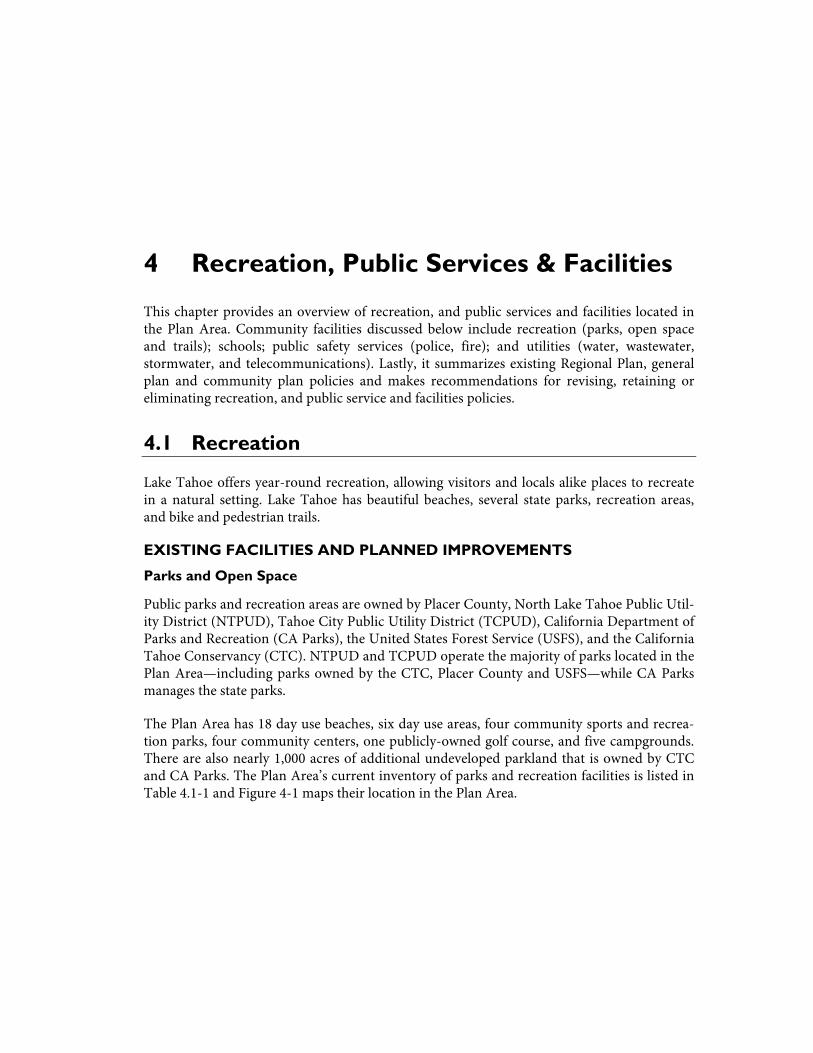
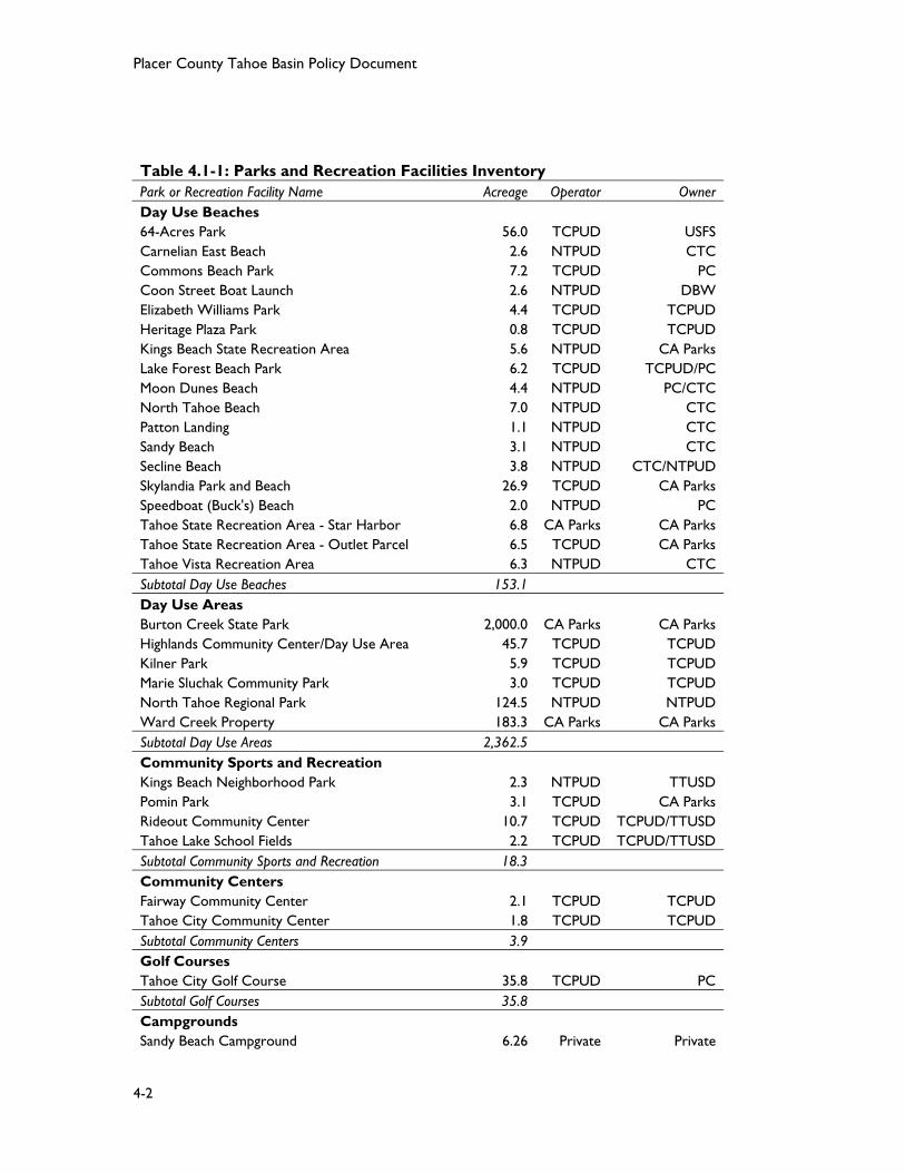
The Plan Area has 18 day use beaches, six day use areas, four community sports and recrea-tion parks, four community centers, one publicly-owned golf course, and five campgrounds. There are also nearly 1,000 acres of additional undeveloped parkland that is owned by CTC and CA Parks. The Plan Area’s current inventory of parks and recreation facilities is listed in Table 4.1-1 and Figure 4-1 maps their location in the Plan Area.
Placer County Tahoe Basin Policy Document
4-2
Table 4.1-1: Parks and Recreation Facilities Inventory Park or Recreation Facility Name Acreage Operator Owner Day Use Beaches 64-Acres Park 56.0 TCPUD USFS Carnelian East Beach 2.6 NTPUD CTC Commons Beach Park 7.2 TCPUD PC Coon Street Boat Launch 2.6 NTPUD DBW Elizabeth Williams Park 4.4 TCPUD TCPUD Heritage Plaza Park 0.8 TCPUD TCPUD Kings Beach State Recreation Area 5.6 NTPUD CA Parks Lake Forest Beach Park 6.2 TCPUD TCPUD/PC Moon Dunes Beach 4.4 NTPUD PC/CTC North Tahoe Beach 7.0 NTPUD CTC Patton Landing 1.1 NTPUD CTC Sandy Beach 3.1 NTPUD CTC Secline Beach 3.8 NTPUD CTC/NTPUD Skylandia Park and Beach 26.9 TCPUD CA Parks Speedboat (Buck's) Beach 2.0 NTPUD PC Tahoe State Recreation Area - Star Harbor 6.8 CA Parks CA Parks Tahoe State Recreation Area - Outlet Parcel 6.5 TCPUD CA Parks Tahoe Vista Recreation Area 6.3 NTPUD CTC Subtotal Day Use Beaches 153.1 Day Use Areas Burton Creek State Park 2,000.0 CA Parks CA Parks Highlands Community Center/Day Use Area 45.7 TCPUD TCPUD Kilner Park 5.9 TCPUD TCPUD Marie Sluchak Community Park 3.0 TCPUD TCPUD North Tahoe Regional Park 124.5 NTPUD NTPUD Ward Creek Property 183.3 CA Parks CA Parks Subtotal Day Use Areas 2,362.5 Community Sports and Recreation Kings Beach Neighborhood Park 2.3 NTPUD TTUSD Pomin Park 3.1 TCPUD CA Parks Rideout Community Center 10.7 TCPUD TCPUD/TTUSD Tahoe Lake School Fields 2.2 TCPUD TCPUD/TTUSD Subtotal Community Sports and Recreation 18.3 Community Centers Fairway Community Center 2.1 TCPUD TCPUD Tahoe City Community Center 1.8 TCPUD TCPUD Subtotal Community Centers 3.9 Golf Courses Tahoe City Golf Course 35.8 TCPUD PC Subtotal Golf Courses 35.8 Campgrounds Sandy Beach Campground 6.26 Private Private
Chapter 4: Recreation, and Public Services & Facilities Existing Conditions Report
4-3
Table 4.1-1: Parks and Recreation Facilities Inventory Park or Recreation Facility Name Acreage Operator OwnerKaspian Campground and Picnic Area 34.04 Private USFSTahoe State Recreation Area 16.33 CA Parks CA ParksWilliam Kent Campground/Beach 24.72 Private USFSLake Forest Campground 2.13 TCPUD PC/TCPUDSubtotal Campgrounds 83.5 Undeveloped Parkland Dollar Property 969.1 CTC CTCParcels 3081 and 3082 5.3 CA Parks CA ParksTahoe State Recreation Area 1.9 CA Parks CA ParksSubtotal Undeveloped Parkland 976.2 Note: North Lake Tahoe Public Utility District (NTPUD), Tahoe City Public Utility District (TCPUD),
California State Parks (CA Parks), California Tahoe Conservancy (CTC), United States Forest
Service (USFS), Placer County (PC), Tahoe-Truckee Unified School District (TTUSD), and
California State Department of Boating and Waterways (DBW). Sources: TRPA, Placer County; 2013.
Bike and Pedestrian Trails
A number of bike and pedestrian paths are found throughout the Plan Area. In recent years the popularity of trails has increased and is now one of the most popular recreation activities in the Tahoe Basin. TCPUD reports annual usage in excess of 500,000 people annually on their multi-use bike trail along the west shore, through Tahoe City, and along the Truckee River. The multi-use bike trial consists of the Lakeside Trail from Dollar Point to Tahoe City, the West Shore Trail from Tahoe City to Meeks Bay, and the Truckee River Trail from Tahoe City to Squaw Valley. The Plan Area’s current inventory of bike and pedestrian trails is listed in Table 4.1-2. Figure 4-1 maps their location in the Plan Area. Existing and proposed bicycle and pedestrian facilities and their role in the transportation network are also discussed in Chapter 5, Transportation.
Planned Improvements
Future trail sections are planned for the North Tahoe-Truckee Loop Trail. There are two gaps in the Lakeside Trail system one within Tahoe City, and the other within the Homewood area on the west shore. These gaps in an otherwise continuous trail system network are the highest priority for completion. Other priorities are extensions to existing paths that begin to com-plete the round-the-lake network, such as Phase 1 of the Nevada Stateline-to-Stateline Bikeway.
There are currently seven proposed improvements to the bicycle and pedestrian network in the Plan Area. TCPUD is working on a one-mile improvement for the Lakeside Trail. Placer County is making improvements to the North Tahoe Bike Path from Dollar Hill to the North Regional Park and to sidewalks in Kings Beach. TCPUD is also making pedestrian and biking improvements to Fanny Bridge. For further discussion of planning bike and pedestrian im-provements see Chapter 5, Transportation.
Placer County Tahoe Basin Policy Document
4-4
Table 4.1-2: Existing and Proposed Trails
Trail Location Length (miles)
Existing Trails 64-Acres Tahoe City 0.8 Eagle Rock Trail Tahoe City 1.2 Lakeside Trail Tahoe City 1.2 Pinedrop Trail Kings Beach 1.5 Rubicon Trail Tahoma 22.0 State Route 28 Tahoe City 2.2 Tahoe Rim Trail Tahoe City, Tahoe Pines, Homewood 35.9 Truckee River Trail Tahoe City 3.5 West Shore Bike Trail Tahoe City, Sunnyside, Homewood, Tahoma 8.6 Proposed Trails Brockway Vista Path Kings Beach 1.0 Dollar Creek Shared Use Trail Kings Beach 2.2 Lake Forest Trail Dollar Point 0.3 National Ave Bike Path Tahoe Vista North Tahoe Bike Path Dollar Hill, Tahoe Vista 8.5 Northstar Trail Tahoe Vista 3.6 West Shore Bike Trail Homewood, Sunnyside 1.5 Source: Placer County, 2013; Truckee North Tahoe Transportation Management Association, 2011.
Chapter 4: Recreation, and Public Services & Facilities Existing Conditions Report
4-7
4.2 Schools
Existing Facilities
The Plan Area is served by the Tahoe-Truckee Unified School District (TTUSD). The District office is located in the town of Truckee and serves about 4,000 students in California’s Neva-da, Placer and El Dorado counties. District boundaries stretch from Hobart Mills, eight miles north of Truckee to Emerald Bay, near South Lake Tahoe; and from Cisco Grove, 20 miles to the west, to Floriston, 15 miles to the east. The district encompasses more than 720 square miles. Schools within the Plan Area are Kings Beach Elementary (K-4), Tahoe Lake Elemen-tary (K-4), North Tahoe Middle School (5-8), North Tahoe High School (9-12), and Cold Stream Alternative School (6-12). Altogether, more than 1,400 students attend public schools in the Plan Area. Public schools, enrollment and capacity for each school are detailed in Table 4.2-1 and are mapped on Figure 4-2.
Table 4.2-1: Existing Schools in Tahoe-Truckee Unified School District
School Total Enrollment
2012-13Total
CapacityPercent
Underutilized Elementary Schools (K-4) Kings Beach Elementary School 355 496 28% Tahoe Lake Elementary School 330 304 -9% Middle Schools (5-8) North Tahoe Middle School 424 535 21% High Schools (9-12) North Tahoe High School 303 631 52% Alternative Schools Cold Stream Alternative 30 n/a n/a Total 1,442 1,966 27% Sources: California Department of Education, Tahoe Truckee Unified School District Master Plan; 2007.
Sierra College is the regional community college that serves the Northern California foothill counties of Placer, Nevada as well as parts of El Dorado and Sacramento. The Tahoe-Truckee campus is located at 11001 College Trail in Truckee, and serves the communities of Truckee, Squaw Valley, Alpine Meadows, Tahoe City, Kings Beach, Incline Village, and other locations on Tahoe’s north and west shores. The first permanent building at the Tahoe-Truckee cam-pus was completed in 2008 and is designed to serve a student body of approximately 1,000 students. Signature programs include social and behavioral sciences, psychology, business accounting, business administration, and natural sciences transfer programs. In fall 2011 en-rollment at the Tahoe-Truckee campus was a little more than 560 students.
Chapter 4: Recreation, and Public Services & Facilities Existing Conditions Report
4-11
4.3 Public Safety Services
POLICE SERVICES
Existing Facilities and Planned Improvements
Placer County Sherriff’s Department (PCSD) provides law enforcement within the Plan Area. PCSD has a service area of approximately 125 square miles, stretching from Tahoma on the southern boundary, around the northern and western shores of Lake Tahoe to the Califor-nia/Nevada State line, north to Truckee, and west to the crest of the Sierra Nevada.
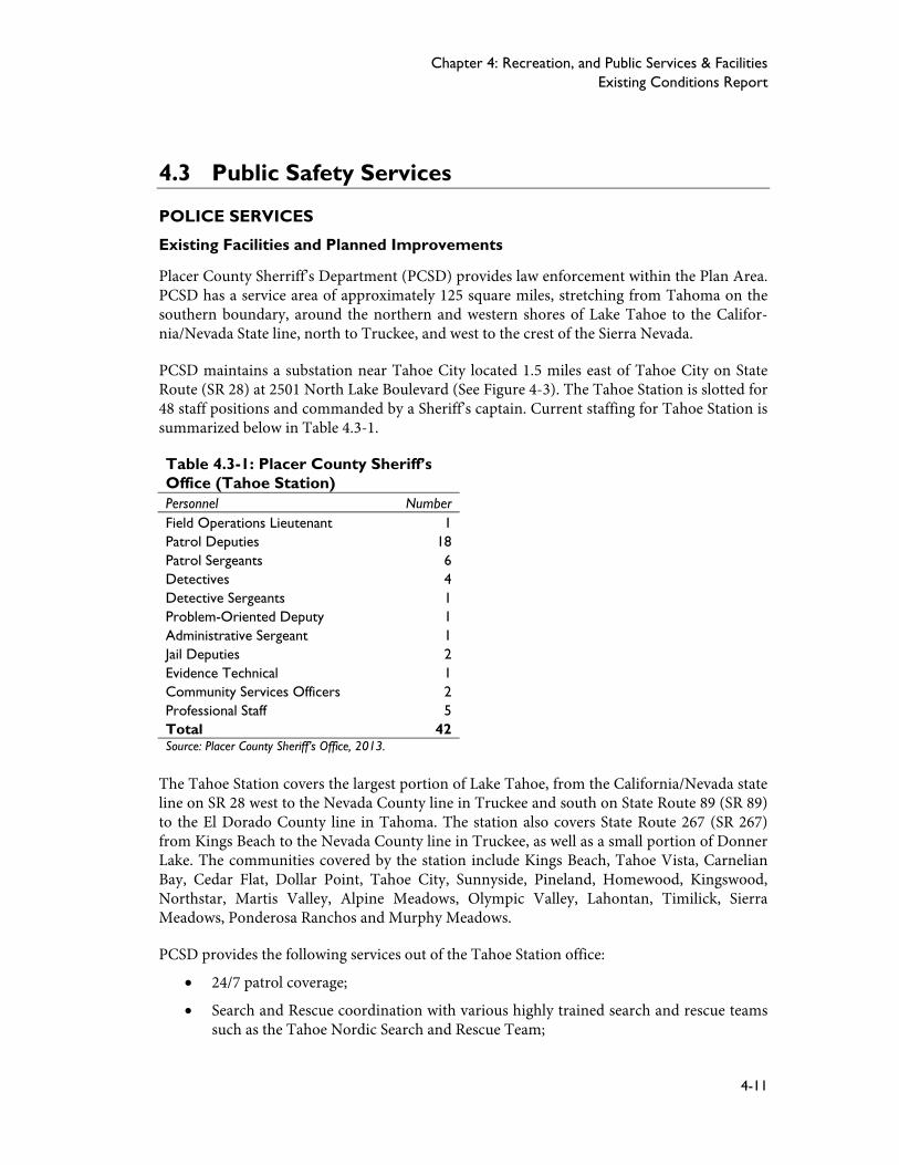
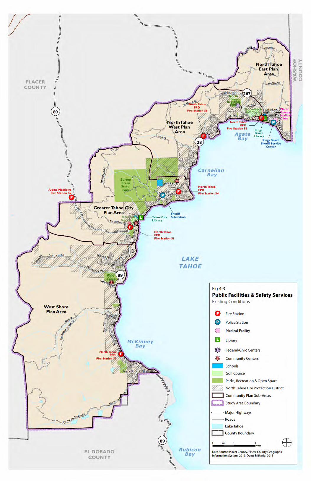
PCSD maintains a substation near Tahoe City located 1.5 miles east of Tahoe City on State Route (SR 28) at 2501 North Lake Boulevard (See Figure 4-3). The Tahoe Station is slotted for 48 staff positions and commanded by a Sheriff’s captain. Current staffing for Tahoe Station is summarized below in Table 4.3-1.
Table 4.3-1: Placer County Sheriff’s Office (Tahoe Station) Personnel NumberField Operations Lieutenant 1Patrol Deputies 18Patrol Sergeants 6Detectives 4Detective Sergeants 1Problem-Oriented Deputy 1Administrative Sergeant 1Jail Deputies 2Evidence Technical 1Community Services Officers 2Professional Staff 5Total 42Source: Placer County Sheriff’s Office, 2013.
The Tahoe Station covers the largest portion of Lake Tahoe, from the California/Nevada state line on SR 28 west to the Nevada County line in Truckee and south on State Route 89 (SR 89) to the El Dorado County line in Tahoma. The station also covers State Route 267 (SR 267) from Kings Beach to the Nevada County line in Truckee, as well as a small portion of Donner Lake. The communities covered by the station include Kings Beach, Tahoe Vista, Carnelian Bay, Cedar Flat, Dollar Point, Tahoe City, Sunnyside, Pineland, Homewood, Kingswood, Northstar, Martis Valley, Alpine Meadows, Olympic Valley, Lahontan, Timilick, Sierra Meadows, Ponderosa Ranchos and Murphy Meadows.
PCSD provides the following services out of the Tahoe Station office:
24/7 patrol coverage;
Search and Rescue coordination with various highly trained search and rescue teams such as the Tahoe Nordic Search and Rescue Team;
Placer County Tahoe Basin Policy Document
4-12
One of the few certified high-altitude dive teams in the state. The team is used for res-cue and recovery for both swiftwater and underwater operations;
Boat patrol for the largest portion of Lake Tahoe;
Bike patrol during special events.
The Sheriff’s Office does not presently have any planned improvements to the Tahoe Station, as existing facilities are currently adequate to maintain a sufficient level of service for antici-pated future population growth.
Facility and Response Time Standards
The Placer County General Plan Policy 4.H.1 specifics a goal of one officer per 1,000 resi-dents. Due to the transient nature and widely fluctuating seasonal population, there is no spe-cific ratio goal for the Lake Tahoe area. Normally three officers are on patrol at one time. Re-sponse times vary depending upon weather conditions and other calls for service.1
FIRES SERVICES
Existing Facilities and Planned Improvements
The North Tahoe Fire Protection District (NTFPD) provides fire, rescue, hazardous materi-als, river rescue, technical rope rescue, vehicle extrication, advanced life support ambulance service, pre-fire planning, and public education services within the Plan Area. NTFPD was created in 1993 through the consolidation of the North Tahoe and Tahoe City Fire Protection Districts and protects approximately 31 square miles within the district boundary. NTFPD also provides additional services beyond district boundaries to the communities of Alpine Meadows (full services) and within El Dorado County from the county boundary to Emerald Bay (ambulance service only).
Currently there are six fire stations that serve the communities of Alpine Meadows, Tahoe City, Homewood, Dollar Hill, Carnelian Bay, and Kings Beach. Most of the district’s fire sta-tions were constructed in the 1960s and 1970s and have been maintained to a high standard. In July 2012 NTPFD relocated Station 51 from 300 North Lake Boulevard to 222 Fairway Drive in Tahoe City, across from TCPUD. Station 51 serves as the district’s headquarters and is expected to accommodate projected growth in demand for services over the next 15 years.2 Figure 4-3 maps the location of the fire stations located in the Plan Area.
NTFPD is staffed by 49 uniformed and support personnel and provides service to 20,000 resi-dents within the service area. Table 4.3-2 shows the breakdown of personnel at the Depart-ment.
1 Public Services and Utilities. Homewood Mountain Resort Ski Area Master Plan EIR/EIS (2011).
2 Fire/Emergency Protection Services, Municipal Service Review. Placer LAFCO.
Chapter 4: Recreation, and Public Services & Facilities Existing Conditions Report
4-13
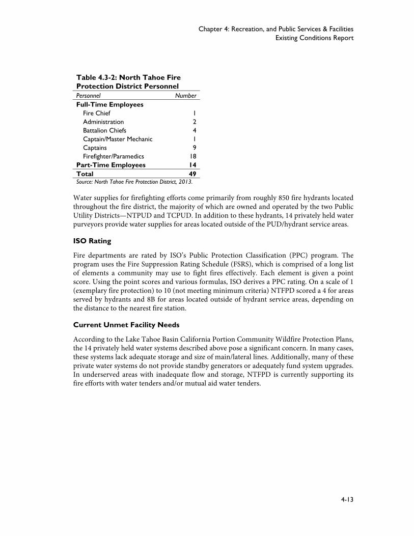
Table 4.3-2: North Tahoe Fire Protection District Personnel Personnel NumberFull-Time Employees
Fire Chief 1Administration 2Battalion Chiefs 4Captain/Master Mechanic 1Captains 9Firefighter/Paramedics 18
Part-Time Employees 14Total 49Source: North Tahoe Fire Protection District, 2013.
Water supplies for firefighting efforts come primarily from roughly 850 fire hydrants located throughout the fire district, the majority of which are owned and operated by the two Public Utility Districts—NTPUD and TCPUD. In addition to these hydrants, 14 privately held water purveyors provide water supplies for areas located outside of the PUD/hydrant service areas.
ISO Rating
Fire departments are rated by ISO’s Public Protection Classification (PPC) program. The program uses the Fire Suppression Rating Schedule (FSRS), which is comprised of a long list of elements a community may use to fight fires effectively. Each element is given a point score. Using the point scores and various formulas, ISO derives a PPC rating. On a scale of 1 (exemplary fire protection) to 10 (not meeting minimum criteria) NTFPD scored a 4 for areas served by hydrants and 8B for areas located outside of hydrant service areas, depending on the distance to the nearest fire station.
Current Unmet Facility Needs
According to the Lake Tahoe Basin California Portion Community Wildfire Protection Plans, the 14 privately held water systems described above pose a significant concern. In many cases, these systems lack adequate storage and size of main/lateral lines. Additionally, many of these private water systems do not provide standby generators or adequately fund system upgrades. In underserved areas with inadequate flow and storage, NTFPD is currently supporting its fire efforts with water tenders and/or mutual aid water tenders.
Chapter 4: Recreation, and Public Services & Facilities Existing Conditions Report
4-17
4.4 Utilities
The Plan Area is served by a comprehensive network of infrastructure and utilities that sup-port its economic function and growth. Various public and private utility companies provide water, sewer and telecommunication services within the Plan Area. This section describes the existing infrastructure and utilities, as well as infrastructure and service improvements that are needed to accommodate existing development and future growth.
PUBLIC UTILITY DISTIRCTS
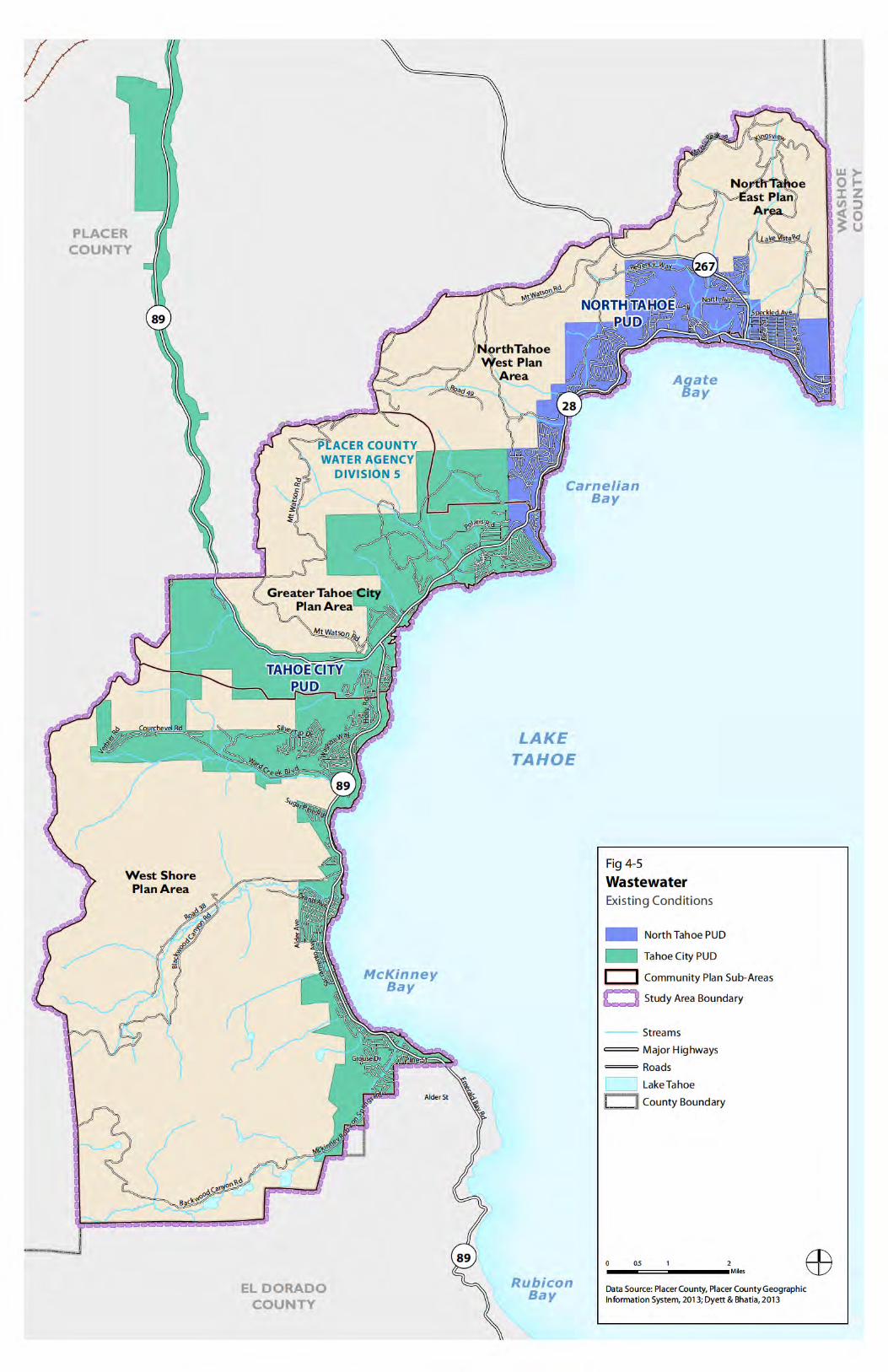
Two public utility districts—NTPUD and TCPUD—provide water and sewer services to the majority of residents that live within the Plan Area (see Figure 4-4 and Figure 4-5). NTPUD and TCPUD were established in accordance with California’s Public Utility District Act of 1929, which provides for the creation of a separate public agency to supply electricity, water, or other utility services within an unincorporated area of the county. Districts are designated as “independent districts” by the State and are governed by a board of directors, all of whom must be residents and registered voters of the district.
North Lake Tahoe Public Utility District (NTPUD)
NTPUD was formed in 1948 to provide sewer service to the residents of the north shore. The district’s boundaries stretch from the Nevada State line in Crystal Bay to Dollar Hill, and in-clude the communities of Kings Beach, Tahoe Vista, Brockway Vista, Carnelian Bay, Cedar Flat, and Agate Bay. In 1967, NTPUD added water service, and in 1968 formed the Recreation and Parks Department, which manages and maintains most of the public beaches within the service area, as well as North Tahoe Regional Park. Currently, NTPUD has 3,872 water con-nections and 5,525 sewer connections.
Tahoe City Public Utility District (TCPUD)
TCPUD was formed in 1938 and is the oldest local government in the Tahoe Region. The boundaries of the district extend from Emerald Bay to Dollar Hill, and along the Truckee Riv-er to the Nevada County line. Initially, the district formed to provide water service, and was later expanded to include sewer service and parks and recreation. Water service is provided in five separate systems and serves about half of the homes and businesses in the district (includ-ing the Rubicon service area located in El Dorado County). Sewer collection and parks and recreation are provided for the entire area of the district. Currently, TCPUD has 4,044 water connections and 7,540 sewer connections.
Placer County Tahoe Basin Policy Document
4-18
WATER
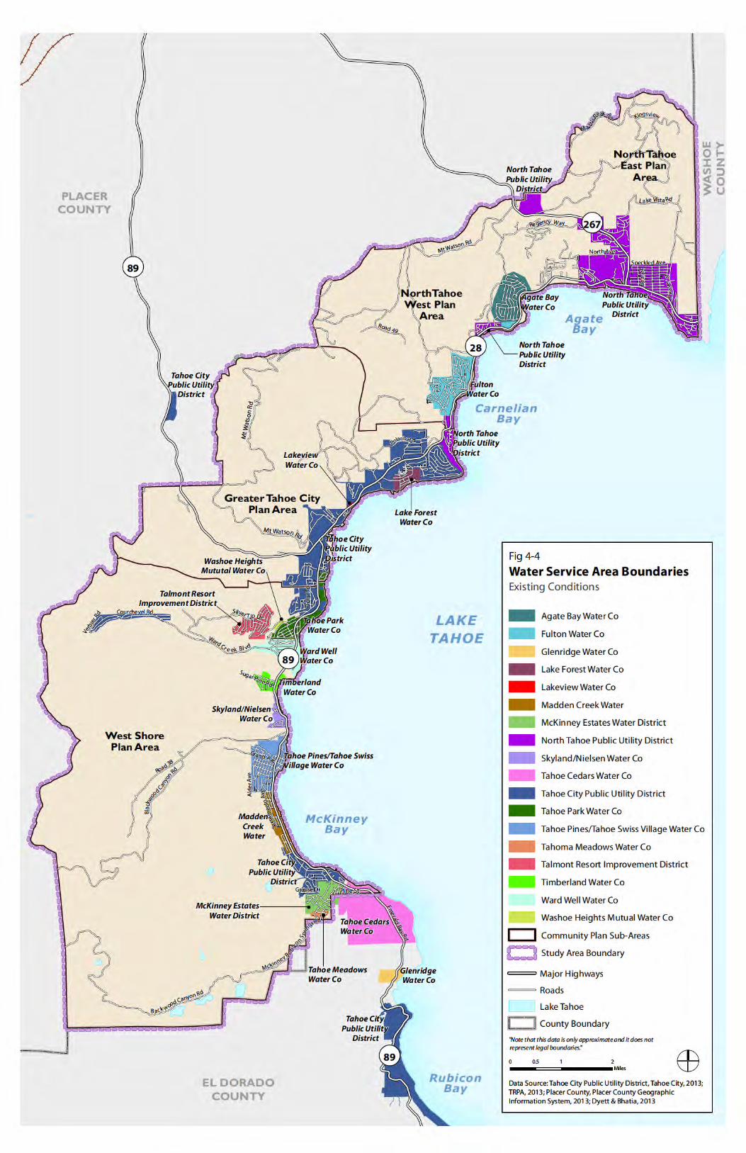
Drinking water for the Plan Area comes primarily from Lake Tahoe itself, local streams, smaller nearby lakes, and groundwater. The two largest water providers in the Plan Area are NTPUD and TCPUD. Additionally, a number of smaller public and private water companies provide drinking water to residents located outside of public utility district boundaries. See Figure 4-4 for the location of district service areas for water purveyors in the Plan Area.
Additional public and private water companies located within the Plan Area boundary in-clude:
Agate Bay Water Company
Fulton Water Company
Lakeview Water Company
Madden Creek Water Company
McKinney Estates Water District (public)
Skyland/Nielsen Water Company
Tahoma Meadows Water Company
Tahoe Park Water Company
Tahoe Pines/Tahoe Swiss Village Water Company
Tahoe Cedars Water Company
Talmont Resort Improvement District (public)
Ward Well Water Company
Washoe Heights Water Company
Water Supply and Demand
Drinking water within the Plan Area comes from surface water diversions from Lake Tahoe and groundwater wells. Lake Tahoe is the largest alpine lake in the North American continent and the second deepest lake in the United States containing an estimated 40 trillion gallons of water (122 million acre feet). The source of water for Lake Tahoe is precipitation that falls either directly into the lake or drains from one of the 63 sub watersheds located within the Tahoe Basin. Water in Lake Tahoe is 99.7 percent pure.
The Truckee River Operating Agreement (TROA), which was approved on September 6, 2008, was developed to formalize, regulate, and monitor water rights and water use within the Tahoe Region, the Truckee River Watershed, and the final outflow areas of Pyramid Lake and the Carson River. This agreement was designed to improve the operational flexibility of Truckee River reservoirs and represents the culmination of 18 years of negotiation. Under the TROA, Tahoe Region water rights for surface water and groundwater are capped at 34,000 acre-feet annually, with 11,000 acre-feet per year designated for use in Nevada and 23,000 acre-feet per year for use in California.
Chapter 4: Recreation, and Public Services & Facilities Existing Conditions Report
4-19
North Lake Tahoe Public Utility District (Water Service)
NTPUD relies almost entirely on surface water for its drinking water supply. About 90 per-cent of water supplies come from surface water diversions from Lake Tahoe, with the remain-ing supply coming from groundwater wells. The district’s water system is comprised of three lake intakes, groundwater wells, eight storage facilities (with approximately 3.5 million gal-lons of storage), three booster systems, and forty-five miles of water lines. Only one of the lake intakes—National Avenue intake—is currently in operation. NTPUD currently services 3,872 water connections and as of 1984 all water connections within the district were me-tered.
As shown in Figure 4-4, the district operates three separate and independent water systems including Dollar Cove, Carnelian Bay, and the Tahoe Main system. The Tahoe Main system has 3,326 connections and serves the communities of Kings Beach and Tahoe Vista. It draws water from Lake Tahoe, as well as from a groundwater well located in the North Tahoe Re-gional Park. Water pumped from Lake Tahoe is treated at the National Avenue Water Treat-ment Plant, and provides approximately 90 percent of the water produced by the district. The Carnelian system serves the community of Carnelian Bay and receives its water from a groundwater well. The Carnelian system has 273 connections. The Dollar Cove system serves the community of Dollar Cove and purchases water from TCPUD. Dollar Cove has 273 con-nections.
In 2010, the district’s gross water demand was 1.8 million gallons per day (mgd), which is projected to increase to 3.2 mgd by 2030. In 2010, approximately 90 percent of water deliver-ies were for residential uses, 6 percent for commercial-hotel/resorts, 2 percent for irrigation, and 2 percent for fire. NTPUD plans to meet 2030 water demand using existing water supply sources. Additionally, the Dollar Cove lake intake, which is currently inactive can supply 240 gpm, if necessary.
NTPUD recently completed a new 1.3 million gallon water storage tank off of SR 267 in Kings Beach at the end of Canterbury Drive. This tank serves as added water storage and supports wildfire suppression efforts. With the installation of this tank and booster station, the district will be able to demolish the existing Kingswood 500,000 gallon tank and booster station that is currently within the Griff Creek stream zone and restore the creek to its natural state.
Tahoe City Public Utility District (Water Service)
In contrast to NTPUD, TCPUD relies almost entirely on groundwater sources for its drinking water supply. Up until the late 1980s, TCPUD relied mostly on surface water diversions from Lake Tahoe, however has since reduced its dependence on Lake Tahoe and now relies almost entirely on groundwater wells for its drinking water supply. About 95 percent of water sup-plies come from groundwater sources, with the remaining water supply coming from surface water diversions from Lake Tahoe.
As shown in Figure 4-4, TCPUD service area currently consists of five separate and distinct sub-regional water systems including Tahoe City Main, McKinney/Quail, Alpine Peaks, Ta-hoe-Truckee Forest Tract, and Rubicon (located in El Dorado County). The Tahoe City Main system has 2,600 connections and five groundwater wells and provides water to an area that
Placer County Tahoe Basin Policy Document
4-20
extends from Dollar Point to Tahoe Tavern. The McKinney/Quail system has 450 connec-tions and extends from Homewood, south and east along the shoreline to McKinney Creek. The Tahoe-Truckee Forest Tract has 18 connections and serves properties along SR 89 to the eastern end of Squaw Valley Road. The Alpine Peaks system has 90 connections and two spring wells located 5 miles west of Tahoe City and serves the area of Tahoe Tavern.
TCPUD currently services 3,910 water connections and recently acquired the Lake Forest Water Company, a private water company that serviced the Lake Forest Subdivision located northwest of Tahoe City. The Lake Forest area includes an additional 118 water connections in a small mixed-use neighborhood. The Lake Forest water system is currently being com-pletely rebuilt, funded by grants from the California Department of Public Health.
In 2010, the district’s gross water demand was 1.0 mgd, which is projected to increase to 1.1 mgd by 2030. In 2010, approximately 91 percent of water deliveries were for residential uses, 5 percent for institutional/governmental and 4 percent for commercial.
Future surface water supply development is planned for the Tahoe City Main system, which will include a new lake intake and treatment plant that will supply approximately 1,000 GPM. TCPUD also plans to increase its yield at the McKinney/Quail intake from 300 to 500 GPM. By 2020, surface water diversions from Lake Tahoe are expected to account for nearly 30 per-cent of TCPUDs water supply. Additionally, in the past the district has experienced difficul-ties in meeting summer peak water demands for the McKinney/Quail system. To provide ad-ditional supply, in 2004, the district installed an interim surface water treatment system to meet demands. Funding is currently earmarked in the Tahoe City PUD 5-year Capital Im-provement Program (CIP) for construction of a permanent surface water treatment system.
Other Public and Private Water Companies
Historically many of the smaller public and private water companies within the Plan Area relied on surface water diversions from Lake Tahoe. However since passage of the California Safe Drinking Water Act in 1986, which required that all surface water be treated prior to use by a consumer. The majority of these companies now rely primarily on groundwater sources for drinking water. Some of the smaller water companies in recent years have had difficulty in meeting federal and state water quality standards. Most recently Lake Forest Water Company was acquired by TCPUD when 72 percent of the Company’s customers petitioned the TCPUD board to acquire the system. TCPUD had supplied the Lake Forest Water Company with drinking water since 2001 before acquiring it through eminent domain proceedings in 2011.
Lahonton Regional Water Quality Control Board
The primary responsibility for the protection of water quality in California rests with the State Water Resources Control Board (State Board) and nine Regional Water Quality Control Boards. The State Board sets statewide policy for the implementation of state and federal laws and regulations. The Regional Boards adopt and implement Water Quality Control Plans (Basin Plans) which recognize regional differences in natural water quality, actual and poten-tial beneficial uses, and water quality problems associated with human activities.
Chapter 4: Recreation, and Public Services & Facilities Existing Conditions Report
4-21
The jurisdiction of the California Regional Water Quality Control Board, Lahontan Region (Regional Board) extends from the Oregon border to the northern Mojave Desert and in-cludes all of California east of the Sierra Nevada crest. This region includes Lake Tahoe and the Lake Tahoe Basin.
WASTEWATER COLLECTION AND TREATMENT
NTPUD and TCPUD provide wastewater collection and Tahoe-Truckee Sanitation Agency (TTSA) provides wastewater treatment for the Plan Area. The 1969 Porter-Cologne Water Quality Control Act in California and executive order by the Governor of Nevada (dated Jan-uary 27, 1971) prohibited the discharge of domestic, municipal or industrial wastewater into Lake Tahoe, its tributaries, groundwater, or the portion of the Truckee River within the Ta-hoe Basin. Following, treatment plants were retrofitted with export pipelines and pump sta-tions to transport wastewater out of the Tahoe Basin. In 1971, both states also prohibited the use of septic tanks requiring all sewage generators in the Tahoe Basin to be connected to an existing wastewater system.
Currently, all collected raw sewage is conveyed out of the Tahoe Basin through a large diame-ter gravity pipeline known as the Truckee River Interceptor (TRI), which is owned and oper-ated by TTSA. The TRI conveys all raw sewage 17 miles to Truckee where it is treated at the Truckee Water Reclamation Plant (TWRP). TWRP also treats and disposes of wastewater for Squaw Valley, Alpine Meadows and the Town of Truckee.
North Lake Tahoe Public Utility District (Wastewater Service)
The NTPUD Sewer Department was founded in 1948, and services an area of approximately 6.5 square miles including Kings Beach, Brockway, Tahoe Vista, and surrounding areas (see Figure 4-5). The district’s sanitary sewer collection system consists of approximately 94 miles of gravity sewer pipe, 6 miles of force main, 5,400 lower laterals, 4 main pumping facilities, and 16 satellite pumping facilities. Numerous pumping stations are required to transport the sewage from a number of small communities. Sewage flows in gravity collection lines toward the lake where it is collected and pumped east to west through one or more main pump sta-tions. When the lowest point in a gravity system is too low to flow into a main station, a smaller or satellite pump station lifts the sewage into the main transport system.
Capacity
NTPUD serves 5,524 customers with 4,010 sewer line connections. In 2010, the average daily flow to TWRP was 0.861 mdg. The Design Daily Flow or allocated maximum flow to TWRP is 6 mgd. According to the 2010 NTPUD Risk-Based Sewer System Management Plan, the existing collection system pipeline network has pipeline diameters large enough to convey historic and future sewage loading based on potential growth.
Planned Improvements
Under the NTPUD Capital Improvement Program (CIP), several updates to the sewage sys-tem are being made. A new pump station for Carnelian Bay and Dollar Hill is being consid-ered, and the sewer main at Brook Avenue is being replaced. The project will be completed in the spring of 2013. This project includes the replacement of the existing sewer mains and ser-
Placer County Tahoe Basin Policy Document
4-22
vice laterals in Brook Avenue and Coon Street and the installation of a new sewer main, man-holes, and service laterals on SR 28 between Coon Street and Bear Street in order to abandon a mid-block sewer main in which the district does not have adequate access. Other projects, such as the Beaver Street Water and Sewer Line Replacement Project have already been com-pleted.
Tahoe City Public Utility District (Wastewater Service)
The TCPUD Sewer Department services an area of approximately 22 square miles stretching from D.L. Bliss State Park to the Dollar Point area, extending north from Tahoe City to the Placer/Nevada County line just south of Truckee town limits (see Figure 4-5). The district’s sanitary sewer collection system consists of approximately 130 miles of sewer pipe, 2,349 manholes, and 21 lift stations.
Capacity
NTPUD serves 7,540 sewer connections within the district. In 2010, the average daily flow to TWRP was 0.9 mdg. The Design Daily Flow or allocated maximum flow to TWRP is 7.8 mgd. Over time the flows appear to be decreasing, particularly since 2006. According to the 2010 TCPUD Risk-Based Sewer System Management Plan, there are no known hydraulic capacity limitations within the collection system during dry weather or during peak wet weather events.
Planned Improvements
Under the NTPUD Capital Improvement Program (CIP), several updates to the sewage sys-tem are being made. The primary focus of the CIP in 2013 is the Tahoe City Residential Sewer System Rehabilitation, which will commence with planning and design work in 2013. Other project priorities include pump and control upgrades, sewer flow meters and pump station bypass facilities.
Tahoe Truckee Sanitation Agency
TTSA was created in 1972 in response to the Porter Cologne Water Quality Control Act, which was passed to protect Lake Tahoe and Truckee River water quality. TTSA plans, ad-ministers, and coordinates wastewater treatment and disposal services throughout the north and west Tahoe area, as well as the town of Truckee. TTSA works with five member sewage collection districts including TCPUD, the NTPUD, the Alpine Springs County Water Dis-trict, the Squaw Valley Public Service District, and the Truckee Sanitary District.
TTSA treats and disposes of the wastewater delivered to the facility by the sewage collection agencies. TTSA is located in Martis Valley, east of the town of Truckee in Nevada County. The state-of-the-art 9.6 mgd advanced water reclamation plant provides primary and second-ary treatment, phosphorus removal, biological nitrogen removal, disinfection, and effluent filtration. Because of its location in the pristine Lake Tahoe-Truckee River watershed, the plant is required to meet some of the most stringent effluent requirements in the country.
Chapter 4: Recreation, and Public Services & Facilities Existing Conditions Report
4-23
STORMWATER
Lake Tahoe is listed as “high priority” on the Federal Clean Water Act, Section 303(d) list of waterways impaired by the presence of nutrients due to, among other sources, urban storm-water. Pollutants from residential areas, commercial areas, construction sites, and winter op-erations of roads all contribute to degraded water quality. Data and research indicate that the pollutants with the greatest impact on Lake Tahoe water quality and clarity are fine sediment, phosphorous and nitrogen. Future water quality improvement projects will continue to focus on reducing the discharge of these pollutants. See Section 2.5, Hydrology, Water Quality and Flooding for further discussion of completed and proposed water quality improvement pro-jects in the Plan Area.
The Lake Tahoe Federal Interagency Partnership, created in 1997 to coordinate actions to address environmental and economic concerns at Lake Tahoe and including several Federal agencies (USDA, ACOE, BLM, USDOT, and the EPA) created a subcommittee to address stormwater issues. This subcommittee is known as the Stormwater Quality Improvement Committee, and was established to improve the design and effectiveness of stormwater quali-ty improvement projects and increase the efficiency of implementing water quality improve-ment projects.
A Stormwater Management Plan was adopted to guide the implementation of the stormwater quality program. This program describes the actions and requirements necessary to reduce pollutant loads, including new development requirements. Comprehensive development reg-ulations will always be required to ensure a high standard of environment protection.
Impaired Waters and Total Maximum Daily Load
Stormwater runoff from urbanized land uses is identified by the Lake Tahoe TMDL Technical Report as the largest source of FSP and phosphorous to Lake Tahoe. Stormwater runoff oc-curs when precipitation from rain and snowmelt flows over land and does not infiltrate into the ground. As the runoff flows over the land and impervious surfaces such as streets, parking lots, and rooftops, it accumulates debris, chemicals, sediment or other pollutants that impact water quality if left untreated. In the Lake Tahoe Basin, urban stormwater runoff is regulated both as a point source, and by means of Memoranda of Agreements.
In November of 2010, the Lahontan Water Board adopted the Lake Tahoe Total Maximum Daily Load (TMDL) regulations. These regulations were adopted to improve lake clarity and to reduce pollutant loads entering the lake. The goal of the Lake Tahoe TMDL is to set forth a plan to restore Lake Tahoe’s historic deep water transparency to 29.7 meters annual average Secchi depth. Urban uplands runoff, atmospheric deposition, forested upland runoff, and stream channel erosion have been identified by LRWQCB and the Nevada Division of Envi-ronmental Protection as the primary sources of fine sediment particle, nitrogen, and phos-phorous loads discharging to Lake Tahoe. A 20-year interim transparency goal, known as the Clarity Challenge, requires basin-wide pollutant load reductions to be achieved within 15 years, followed by five years of monitoring to ensure desired lake clarity depths are achieved. See Section 2.5, Hydrology, Water Quality and Flooding for further discussion of Lake Tahoe TMDL.

Placer County Tahoe Basin Policy Document
4-24
TELECOMMUNICATIONS
The Plan Area is located in the AT&T service area. AT&T provides telecommunication ser-vices, including local, long distance, DSL, wireless, data networks, and directory to the Lake Tahoe area. AT&T communication infrastructure has sufficient capacity to meet expected future demands for service.
Chapter 4: Recreation, and Public Services & Facilities Existing Conditions Report
4-29
4.5 Policy Context
REGIONAL PLAN
Regional Plan policies addressing recreation and public services and facilities are focused on retaining adequate capacity for future recreational and service needs, and ensuring that ex-pansion of these uses and services do not negatively impact the long-term sustainability of the region’s resources and environmental quality.
Recreation
The Regional Plan provides for the development, utilization, and management of the recrea-tional resources of the region, from “dispersed” activities which normally takes place in the rural portions of the region without supporting constructed facilities, to “developed” recrea-tional activities. The element also discusses urban recreation, such as day use areas and golf courses, which occurs primarily in urban areas and serves local needs.
Providing Opportunities for Recreation. Dispersed recreation involves activities that do not require the use of developed facilities, and rely on a high-quality natural resource base and some degree of solitude. Policies support these activities by identifying areas where low-density recreational experiences shall be prioritized, such as undeveloped shorelines, wilder-ness, and other undeveloped and roadless areas. They identify trail connections to pursue. The policies also ensure that recreational activity does not adversely impact environmental thresholds or disturb habitats and wildlife, and address potential use conflicts associated with dispersed winter sports and nearshore activities. Policies aim to ensure that a fair share of the basin’s development capacity is reserved for the provision of outdoor recreation. Policies state that lands and resources already committed to recreation use shall remain so, and that addi-tional developed outdoor recreation facilities shall be provided for. (Policies: R-1.1, R-1.2, R-1.3, R-1.4, R-1.5, R-2.1, R-2.2, R-2.3, R-3.1, R-3.2, R-3.3)
Developing Outdoor Recreational Uses Appropriately. Outdoor recreational uses should be developed on a basis of demonstrated need, consistent with the maintenance of environmen-tal threshold carrying capacities and existing site amenities. Encouraged development in-cludes public bike trails, boat launching facilities, and campgrounds, and the continued en-couragement for private marinas to allow public use. Those facilities existing in sensitive areas shall be incentivized to relocate to land with higher capability. In general, facilities should be developed in proximity to existing infrastructure, and information facilities shall be located closer to urban areas. Transit should be established to provide service to major recreation fa-cilities and attractions, and parking shall be restricted along scenic corridors to preserve views and vegetation. Regulating the intensity, timing, type, and location of uses will allow for the protection of sensitive resources and reduce conflicts between uses. Informational program-ming and promoting seasonally alternative uses are encouraged to increase the efficient de-velopment of outdoor recreational resources. The policies also seek to ensure the develop-ment of urban recreational facilities to accommodate the specialized needs of local residents. (Policies: R-4.1, R-4.2, R-4.3, R-4.4, R-4.5, R-4.6, R-4.7, R-4.8, R-4.9, R-4.10, 5.1, 5.2, 6.1, 6.2, 7.1, 7.2)
Placer County Tahoe Basin Policy Document
4-30
Develop Recreational Access. Encourage opportunities for dispersed recreation when con-sistent with environmental values and the protection of the natural resources. Policies en-courage the expansion and networking of trail systems. Trails and transportation facilities shall provide low-impact access to undeveloped shorelines for recreational use. The provision of trails should be linked with projected demand, tolerance capability, and special resource and recreation values. Trails that are underutilized or located in environmentally sensitive areas should be redesigned or relocated in order to enhance usage and protect natural re-sources. (Policies: R-1.1, R-1.3, R-1.4)
Addressing Ski Facilities. Policies allow for expansion of existing ski facilities with the prepa-ration of a master plan for the entire ski area consistent with the Regional Plan and the re-quirements of the Bi-State Compact. (Policies: R-4.11, R-6.2)
Infrastructure and Public Services
The Regional Plan establishes the location, scale, and means of providing necessary services and public facilities, in order to support existing and future development, and to help protect the natural environment from impacts associated with development.
Maintaining Public Services and Utilities. The Regional Plan allows for continued expan-sion and upgrading of public services and utilities that is consistent with demand and with the provisions of the Regional Plan. Public services and utilities should adequately support new and existing development without creating inefficiencies from over- or under-expansion. Ap-proval of new development shall consider the adequacy of public services and facilities to serve that development. Policies focus specifically on water provision, disallowing additional development requiring water unless its needs can be served within an existing water right and by existing storage and distribution systems, which must be able to adequately serve domestic consumption and fire protection needs. (Policies: PS-1.1, PS-1.2, PS-1.3, PS-2.1, PS-2.3, PS-4.2)
Protecting Surface and Groundwaters. The Regional Plan contains policies to prevent mu-nicipal and industrial waste disposal practices from contaminating the waters of Lake Tahoe or other surface and groundwaters within the region. The policies seek to ensure proper man-agement of solid waste and wastewater through prohibiting wastewater discharge to surface and groundwaters and controlling the reduction, collection, and transport of solid waste. Ad-ditionally, groundwater development should be discouraged in SEZ lands if it could potential-ly impact vegetation or instream flows. (Policies: PS-3.1, PS-3.2, PS-3.3, SEZ-1.3)
Ensuring Educational and Safety Services. Policies seek to ensure that educational and pub-lic safety services anticipate and plan for projected demands. (Policies: PS-4.1, PS-4.2)
PLACER COUNTY POLICY CONTEXT
The existing General Plan, Community Plan, and Plan Area Statements contain over 90 goals, objectives, and policies related to recreation and public services, many of which are duplicat-ed in numerous plans or convey the same principles and direction using different language. See Appendix D, Existing Recreation and Public Services Goals, Objectives, and Policies, for a list of the existing goals, objectives, and polices.
Chapter 4: Recreation, and Public Services & Facilities Existing Conditions Report
4-31
Recreation
An overarching goal related to recreation is to preserve and enhance the high quality recrea-tional experience of the Region. Individual goals, policies, and objectives address each of the topic areas addressed by Regional Plan policies and generally aim to ensure high-quality rec-reational opportunities consistent with environmental values.
A number of policies call for increased public access to the Truckee River and Lake Tahoe. Policies also support increasing the total mileage of bicycle trails, specifically connections to the North Tahoe PUD Bike Trail, expanded public camping facilities, continued opportuni-ties for cross-country skiing, and maintaining the viability of area golf courses. Expansion of the marina is supported in order to accommodate increasing boating needs and the need for a public pier is identified. Policies call for coordination with the planning programs of a variety of entities, including the U.S. Forest Service, the Tahoe City PUD, and the Lake Tahoe Con-servancy.
Policies address the relationship between environmental protection and recreational oppor-tunities by limiting or prohibiting off-road vehicle and snowmobile use in certain areas and directing facilities to good capability lands within close proximity to urban services.
Generally, policies call for a coordinated approach to the planning and operation of ski facili-ties. Generally, base facilities and accessory uses should be accessed from outside the Basin. Policies encourage the upgrading and redevelopment of the Homewood base ski facilities.
Infrastructure and Public Services
The overarching goal related to infrastructure and public services is to support existing and new development and ensure attainment of environmental targets. Public and private infra-structure is to be provided for a planned buildout projected for 20 years. Policies call for con-solidation and relocation of some public service facilities, such as the CalTrans corporation yard, out of environmentally and visually sensitive areas. A number of policies are directed toward fire protection, including moving development out of hazardous areas, improving response times, and ensuring compliance with fire safety standards.
ANALYSIS
Overall, the current goals, objectives, and policies are consistent with Regional Plan policy direction for recreation and public services. However, because the goals, objectives, and poli-cies are spread among numerous plans and Plan Area Statements, they lack clarity and a con-sistent framework. Also, because the goals, objectives, and policies were written for relatively small geographic areas, they tend to be narrow in scope.
The overall intent and issue areas of the existing goals, objectives and policies should be re-tained. This includes providing recreational opportunities such as access to the Truckee River and the Lake, a network of bicycle trails, boat launching areas, camping facilities, and other recreational opportunities to serve demand, consistent with environmental values and providing infrastructure and public services to serve development projected for a 20 year pe-riod. However, the individual statements should be revised and augmented to more closely
Placer County Tahoe Basin Policy Document
4-32
align with Regional Plan policies, better articulate the overall approach to recreation and pub-lic services, and provide clear direction for implementation. Where appropriate to address localized issues, policies applicable to specific areas or topics should be retained. Duplicative policies should be eliminated and policies that are very similar to each other, with only minor differences should be consolidated.
New policy initiatives for recreation could include specifically addressing hiking trails and prioritizing reservation of services by types of outdoor uses. In regard to infrastructure and public services, a new policy could clearly state that no additional development requiring wa-ter shall be allowed unless it can be demonstrated that adequate water supply, storage, and distribution exists.