Embed Size (px)
Citation preview
Chapter 4 Section 4(f)/6(f) Evaluation
California High-Speed Rail Authority November 2017
Fresno to Bakersfield Section Page | 4-1 Draft Supplemental EIR/EIS
4 SECTION 4(F)/6(F) EVALUATION This section describes the regulatory setting and the affected environment for Section 4(f)/6(f) properties; the impacts that would result from implementation of the Fresno to Bakersfield Locally Generated Alternative (F-B LGA); and project design features and mitigation measures applicable to the F-B LGA that would reduce these impacts.
This section describes the public parks and recreation lands, open space, wildlife and waterfowl refuges, and historic properties in the study area. The methodologies used to collect and compile data for the affected environment section are summarized below and detailed in Appendix A of the F-B LGA: Section 4(f)/6(f) Methodology Memorandum.
4.1 Regulatory Setting Federal, state, and local laws, regulations, orders, or plans relevant to Section 4(f)/6(f) properties affected by the project are presented below.
4.1.1 Federal 4.1.1.1 U.S. Department of Transportation Act 49 U.S.C. 303(c) (Section 4[f]) Projects undertaken by an operating administration of the United States Department of Transportation or that may receive federal funding and/or discretionary approvals from such an operating administration must comply with Section 4(f) of the Department of Transportation Act of 1966 (Section 4(f)). Section 4(f) protects publicly owned land of parks, recreational areas, and wildlife refuges and historic sites of national, state, or local significance on public or private land that are eligible for listing or are listed on the National Register of Historic Places (NRHP) and therefore protected under Section 106 of the National Historic Preservation Act of 1966 (NHPA). Federal Railroad Administration (FRA) Procedures for Considering Environmental Impacts (64 Federal Register 25445, May 26, 1999) contains FRA processes and protocols for analyzing the potential use of Section 4(f) properties. In addition, although not subject to the Title 23 part 774 regulations regarding Section 4(f) for highways and transit projects, the FRA uses these regulations and associated policy guidance when applying Section 4(f).
The FRA may not approve the use of a Section 4(f) property unless it determines that there is no feasible and prudent alternative to avoid the use of the property and the action includes all possible planning to minimize harm resulting from such use, or the project has a de minimis impact consistent with the requirements of 49 U.S.C. 303(d). An alternative is not feasible if it cannot be built as a matter of sound engineering judgment. In determining whether an alternative is prudent, the FRA may consider if the alternative will result in any of the following:
• Compromise the project to a degree that it is unreasonable to proceed with the project in lightof its stated Purpose and Need.
• Unacceptable safety or operational problems.
• After reasonable mitigation, the project results in severe social, economic, or environmentalimpacts; severe disruption to established communities; severe disproportionate impacts onminority or low-income populations; or severe impacts on environmental resources protectedunder other federal statutes.
• Additional construction, maintenance, or operational costs of an extraordinary magnitude.
• Other unique problems or unusual factors.
• Multiple factors that, while individually minor, cumulatively cause unique problems or impactsof extraordinary magnitude.
Chapter 4 Section 4(f)/6(f) Evaluation
November 2017 California High-Speed Rail Authority
4-2 | Page Fresno to Bakersfield Section Draft Supplemental EIR/EIS
If the FRA determines that there is both the use of a Section 4(f) property and no prudent and feasible alternative to that use, the FRA must ensure the project includes all possible planning to minimize harm to the Section 4(f) property, which includes all reasonable measures to minimize harm or mitigate impacts (49 U.S.C. 303[c][2]).
After identifying the reasonable measures to minimize harm, if there is more than one alternative that results in the use of a Section 4(f) property, the FRA must compare the alternatives to determine which alternative has the potential to cause the least overall harm in light of the preservationist purpose of the statute. The least overall harm may be determined by balancing the following factors:
• The ability to mitigate adverse impacts on each Section 4(f) property (including any measuresthat result in benefits to the property);
• The relative severity of the remaining harm—after mitigation—to the protected activities,attributes, or features that qualify each Section 4(f) property for protection;
• The relative significance of each Section 4(f) property;
• The views of the official(s) with jurisdiction over each Section 4(f) property;
• The degree to which each alternative meets the Purpose and Need for the project;
• After reasonable mitigation, the magnitude of any adverse impacts on properties notprotected by Section 4(f); and
• Substantial differences in costs among the alternatives.
4.1.1.2 Section 6(f) of the Land and Water Conservation Fund Act (16 U.S.C. 460l-8(f) and C.F.R. Title 36, Part 59.1)
State and local governments often obtain grants through the Land and Water Conservation Fund (LWCF) Act to acquire or make improvements to parks and recreation areas. Section 6(f) of the LWCF Act prohibits the conversion of property acquired or developed with these grants to a non-recreational purpose without the approval of the United States Department of the Interior’s National Park Service (NPS). Section 6(f) directs the United States Department of the Interior to ensure that replacement lands of comparable value and function, location, and usefulness, or monetary compensation (used to enhance the remaining land) are provided as conditions to such conversions.
4.2 Affected Environment The Affected Environment section consists of a comparison of the F-B LGA to the complementary portion of the Preferred Alternative that was identified in the Fresno to Bakersfield Section California High-Speed Train Final Project EIR/EIS. As discussed in Section 1.1.3 of this Draft Supplemental EIR/EIS, the complementary portion of the Preferred Alternative consists of the portion of the BNSF Alternative from Poplar Avenue to Hageman Road and the Bakersfield Hybrid from Hageman Road to Oswell Street (further referenced as the “May 2014 Project” in this Draft Supplemental EIR/EIS). Since the Fresno to Bakersfield Section Final EIR/EIS does not evaluate the May 2014 Project as a discrete subsection of the Fresno to Bakersfield Project (as it did for example for the Allensworth Bypass), the affected environment and impact summary discussion included in this section for the May 2014 Project has been extrapolated from the available information contained within the Fresno to Bakersfield Section Final EIR/EIS.
4.2.1 Summary of the May 2014 Project Affected Environment The study area for parks, recreational areas, wildlife refuges, and public schools was defined as the May 2014 Project footprint plus a 1,000-foot buffer on either side of the alignment, and a 0.5-mile buffer around the maintenance sites, station areas, and support facilities. The Area of Potential Effects (APE) for the May 2014 Project serves as the study area for Section 4(f) historic properties. See Section 4.2.2.1 below for more information. In the May 2014 Project study area, only those resources identified as eligible for protection under the requirements of Section 4(f)
Chapter 4 Section 4(f)/6(f) Evaluation
California High-Speed Rail Authority November 2017
Fresno to Bakersfield Section Page | 4-3 Draft Supplemental EIR/EIS
and Section 6(f), and identified as potentially affected by the May 2014 Project (due to proximity effects and/or property acquisition), were further evaluated.
The parks, recreation, and open space properties evaluated for Section 4(f) use for the May 2014 Project include: Town Square, Stringham Park, Kirschenmann Park, Austin Creek Park, Kern River Parkway, Jastro Park, McMurtrey Aquatic Center, Bakersfield Amtrak Station Playground, Mill Creek Linear Park, Centennial Plaza, and Central Park. The historic resources evaluated for Section 4(f) use include: the Santa Fe Depot, San Francisco and San Joaquin Valley Railway Shafter Section House, Friant-Kern Canal, Harvey Auditorium/Bakersfield High School, Kern County Civic Administrative Center, Stark/Spencer Residence, Union Avenue Corridor, Salon Juarez, 1031 E 18th Street, and 2509 E California Avenue. No Section 6(f) resources were identified within the May 2014 Project study area. See Appendix 8-A, Analysis of the Comparable Section (May 2014 Project), for more information related to the affected environment for the May 2014 Project.
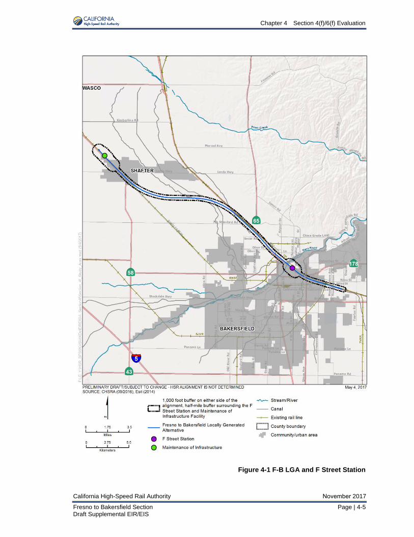
4.2.2 Fresno to Bakersfield Locally Generated Alternative 4.2.2.1 Study Area The study area for parks, recreational facilities, and open space is defined as the center-line plus 1,000 feet on either side of the alignment, and the project alignment plus 0.5 mile around the maintenance of infrastructure (MOIF), station area, and support facilities for the F-B LGA.
Because this project is a federal undertaking, it must also comply with the NHPA. The NHPA implementing regulations at Code of Federal Regulations (C.F.R.) Title 36, Part 800.4(a)(1) require the establishment of an Area of Potential Effects (APE). The APE is the geographic area or areas within which an undertaking may directly or indirectly alter the character or use of historic properties, if any such properties exist. Therefore, the APE serves as the study area for Section 4(f) historic properties that are potentially eligible for listing or are listed on the NRHP.
The APE for historic architectural properties (Built Environment APE) includes all properties that contain buildings, structures, objects, sites, landscapes, and districts more than 50 years of age at the time that the cultural resources survey was conducted. The Built Environment APE is further defined in Section 3.17, Cultural Resources, and includes:
• Properties within the proposed right-of-way.
• Properties where historic materials or associated landscape features would be demolished,moved, or altered by construction.
• Properties near the undertaking where railroad materials, features, and activities have notbeen part of their historic setting and where the introduction of visual or audible elementsmay affect the use or characteristics of those properties that would be the basis for theireligibility for listing in the NRHP.
• Properties near the undertaking that were either used by a railroad or served by a railroad, orwhere railroad materials, features, and activities have long been part of their historic setting,but only in such cases where the undertaking would result in a substantial change from thehistoric use, access, or noise and vibration levels that were present 50 years ago or duringthe period of significance of a property, if different.
Figure 4-1 depicts the F-B LGA alignment and F Street Station. Please refer to Section 4.1.2 of the Fresno to Bakersfield Section Final EIR/EIS for a discussion of the Section 4(f) and 6(f) study area for the previously studied alternatives.

Chapter 4 Section 4(f)/6(f) Evaluation
November 2017 California High-Speed Rail Authority
4-4 | Page Fresno to Bakersfield Section Draft Supplemental EIR/EIS
This page is left intentionally blank
Chapter 4 Section 4(f)/6(f) Evaluation
California High-Speed Rail Authority November 2017
Fresno to Bakersfield Section Page | 4-5 Draft Supplemental EIR/EIS
Figure 4-1 F-B LGA and F Street Station

Chapter 4 Section 4(f)/6(f) Evaluation
November 2017 California High-Speed Rail Authority
4-6 | Page Fresno to Bakersfield Section Draft Supplemental EIR/EIS
This page is left intentionally blank
Chapter 4 Section 4(f)/6(f) Evaluation
California High-Speed Rail Authority November 2017
Fresno to Bakersfield Section Page | 4-7 Draft Supplemental EIR/EIS
4.2.2.2 Section 4(f) Applicability A park or recreation area qualifies for protection under Section 4(f) if it: (1) is publicly owned at the time at which the “use” occurs; (2) is open to the general public for use as a park or recreational facility; and (3) is considered a significant property by the authority with jurisdiction over the area.
A wildlife or waterfowl refuge qualifies for protection under Section 4(f) if it: (1) is publicly owned at the time at which the “use” occurs; (2) is being used as a refuge; and (3) is considered a significant property by the authority with jurisdiction.
A historic property eligible for, or listed in, the NRHP is protected under Section 4(f). Although the statutory requirements of Section 106 and Section 4(f) are similar, if a proposed action results in an “adverse effect” under Section 106, there will not automatically be a Section 4(f) “use.” Therefore, the FRA completes a separate Section 4(f) analysis and determination, in addition to those completed in compliance with the Section 106 process of the NHPA.
For a property to be eligible for the NRHP, it must meet at least one of the four NRHP criteria (i.e., Criteria A through D) described below. The quality of significance in American history, architecture, archaeology, engineering, and culture is present in districts, sites, buildings, structures, and objects that possess integrity of location, design, setting, materials, workmanship, feeling, and association and meet one or more of the following criteria:
• Criterion A: Properties that are associated with events that have made a significantcontribution to the broad patterns of our history;
• Criterion B: Properties that are associated with the lives of persons significant in our past;
• Criterion C: Properties that embody distinctive characteristics of a type, period, or method ofconstruction; or that represent the work of a master; or that possess high-artistic values; orthat represent a significant and distinguishable entity whose components may lack individualdistinction; or
• Criterion D: Properties that have yielded, or may be likely to yield, information important inprehistory or history.
An archaeological property that is eligible only under NRHP Criterion D, as defined above, is considered valuable only in terms of the data that can be recovered from it. For such resources (e.g., pottery scatters and refuse deposits), it is generally assumed that there is minimal value attributed to preserving such resources in place. Conversely, resources eligible under Criteria A, B, and/or C, as defined above, are considered to have value intrinsic to the resource’s location. In other words, Section 4(f) does not apply to a site if it is important chiefly because of what can be learned by data recovery and therefore has minimal value for preservation in place.
4.2.2.3 Section 4(f) Use Definition Permanent Use
A permanent use of a Section 4(f) property occurs when the property is permanently incorporated into a proposed transportation facility as a result of partial or full acquisition, permanent easements, or temporary easements that exceed limits for temporary occupancy, as noted below.
Temporary Occupancy
A temporary occupancy of a Section 4(f) property occurs when there is a temporary occupancy that is considered adverse in terms of the preservationist purposes of the Section 4(f) statute. A temporary occupancy of property does not constitute a use of a Section 4(f) property when the following conditions are satisfied:
• The occupancy must be of temporary duration (e.g., shorter than the period of construction)and must not involve a change in ownership of the property.
• The scope of work must be minor, with only minimal changes to the protected property.
Chapter 4 Section 4(f)/6(f) Evaluation
November 2017 California High-Speed Rail Authority
4-8 | Page Fresno to Bakersfield Section Draft Supplemental EIR/EIS
• There must be no permanent adverse physical impacts on the protected property ortemporary or permanent interference with activities or purpose of the property.
• The property being used must be fully restored to a condition that is at least as good asexisted before project construction.
• There must be documented agreement of the appropriate officials having jurisdiction over theproperty regarding the foregoing requirements.
Constructive Use
A constructive use of a Section 4(f) property occurs when a transportation project does not permanently incorporate the whole or any portion of a protected property, but the proximity of the project results in impacts (e.g., noise, vibration, visual, access, ecological) that are so severe that the protected activities, features, or attributes that qualify the property for protection under Section 4(f) are substantially impaired. Substantial impairment occurs only if the protected activities, features, or attributes of the property are substantially diminished. This determination is made after taking the following steps:
• Identifying the current activities, features, or attributes of the property that may be sensitive toproximity impacts.
• Analyzing the potential proximity impacts on the property.
• Consulting with the appropriate officials having jurisdiction over the property.
It is important to note an indirect adverse effect under Section 106 of the NHPA to a historic property does not, in and of itself, result in a constructive use.
De Minimis Impact
According to 49 U.S.C. 303(d), the following criteria must be met to reach a de minimis impact determination:
• For parks, recreation areas, and wildlife and waterfowl refuges, a de minimis impactdetermination may be made if the FRA concludes the transportation project will not adverselyaffect the activities, features, and attributes qualifying the property for protection underSection 4(f) after mitigation. In addition, to make a de minimis impact determination theremust be:
− Public notice and opportunity for public review and comment.
− Concurrence on the effect finding is received from the official(s) with jurisdiction over theproperty.
• For a historic site, a de minimis impact determination may be made if, in accordance with theSection 106 process of the NHPA, the FRA determines that the transportation program orproject will have no effect or no adverse effect on historic properties, the FRA has receivedwritten concurrence from the official(s) with jurisdiction over the property, (e.g., the StateHistoric Preservation Officer [SHPO]) and has taken into account the views of consultingparties to the Section 106 process as required by C.F.R. Title 36, Part 800.
4.2.2.4 Coordination During the preparation of this Draft Supplemental EIR/EIS, the California High-Speed Rail Authority (Authority) and FRA have consulted with SHPO, local jurisdictions, and the California Department of Fish and Wildlife to identify and assess impacts on Section 4(f) resources.
Chapter 4 Section 4(f)/6(f) Evaluation
California High-Speed Rail Authority November 2017
Fresno to Bakersfield Section Page | 4-9 Draft Supplemental EIR/EIS
As shown in Table 4-1, the Authority and FRA is in ongoing consultation with the relevant officials with jurisdiction over Section 4(f) properties in the study area regarding the effects of the project on the features and attributes of Section 4(f) properties. The public will have an opportunity to comment on this preliminary supplemental Section 4(f) evaluation when the Draft Supplemental EIR/EIS is published for public review. Comments that the Authority and FRA receive from the public review will be incorporated into the Section 4(f) analysis, and will be addressed, as appropriate, and reflected in this chapter or included in response to comments in the Fresno to Bakersfield Section LGA Final Supplemental EIR/EIS.
Table 4-1 Section 4(f) Consultation
Agency Consulted for Section 4(f) Resources Date(s) Consulted State Historic Preservation Office October 13, 2016 City of Bakersfield October 22 and November 11, 2015 California Department of Fish and Wildlife N/A (no wetland preservations within the study area limits)
4.2.2.5 Parks, Recreation, and Open Space Properties Section 4(f) Applicability Analysis
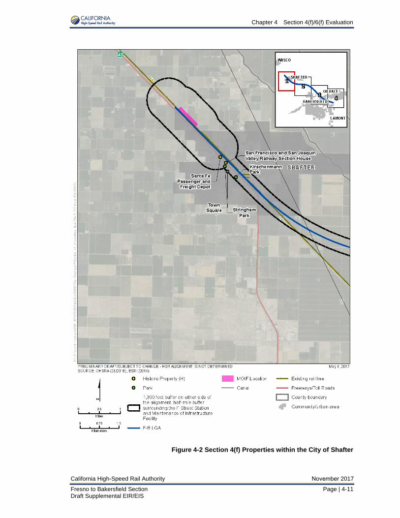
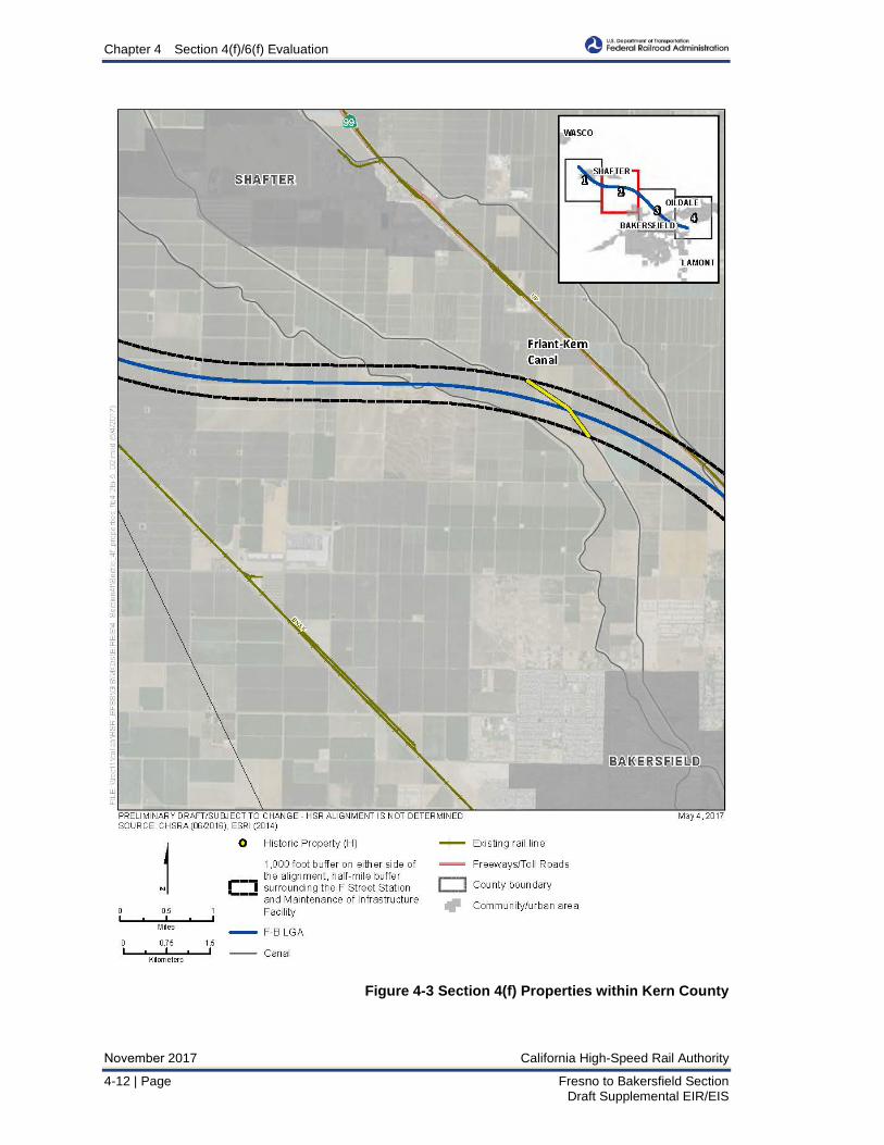
Section 3.15, Parks, Recreation, and Open Space provides a description of each park, recreation, and open space area in the study area; however, not all of these facilities meet the requirements to qualify for protection under Section 4(f). The locations of parks, recreation, and open space properties within the study area are shown on Figure 4-2, Figure 4-3, Figure 4-4, and Figure 4-5. No wildlife or waterfowl refuges exist within the study area. Data collection to identify potential Section 4(f) properties consisted of a review of the plans and policies listed in Table 3.15-1 in Section 3.15 of this Draft Supplemental EIR/EIS, consultation with officials with jurisdiction over properties, field reviews, public input, and the use of geographic information system data banks. Kern County and the cities of Bakersfield and Shafter provided the boundaries for parks and recreation properties in the study area in geographic information system data format and in adopted plans.
Table 4-2, and the following text, describe Section 4(f) parks, recreation, and open space properties that have the potential to incur a Section 4(f) use, or are close enough to the F-B LGA alignment that a discussion of proximity impacts is warranted.

Chapter 4 Section 4(f)/6(f) Evaluation
November 2017 California High-Speed Rail Authority
4-10 | Page Fresno to Bakersfield Section Draft Supplemental EIR/EIS
This page is left intentionally blank
Chapter 4 Section 4(f)/6(f) Evaluation
California High-Speed Rail Authority November 2017
Fresno to Bakersfield Section Page | 4-11 Draft Supplemental EIR/EIS
Figure 4-2 Section 4(f) Properties within the City of Shafter
Chapter 4 Section 4(f)/6(f) Evaluation
November 2017 California High-Speed Rail Authority
4-12 | Page Fresno to Bakersfield Section Draft Supplemental EIR/EIS
Figure 4-3 Section 4(f) Properties within Kern County
Chapter 4 Section 4(f)/6(f) Evaluation
California High-Speed Rail Authority November 2017
Fresno to Bakersfield Section Page | 4-13 Draft Supplemental EIR/EIS
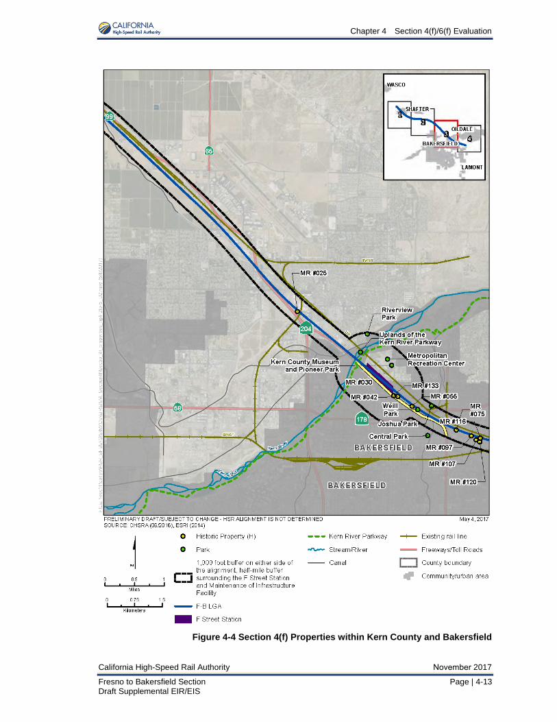
Figure 4-4 Section 4(f) Properties within Kern County and Bakersfield

Chapter 4 Section 4(f)/6(f) Evaluation
November 2017 California High-Speed Rail Authority
4-14 | Page Fresno to Bakersfield Section Draft Supplemental EIR/EIS
Figure 4-5 Section 4(f) Properties within Kern County
Chapter 4 Section 4(f)/6(f) Evaluation
California High-Speed Rail Authority November 2017
Fresno to Bakersfield Section Page | 4-15 Draft Supplemental EIR/EIS
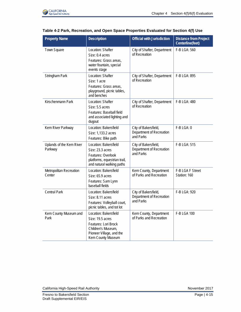
Table 4-2 Park, Recreation, and Open Space Properties Evaluated for Section 4(f) Use
Property Name Description Official with Jurisdiction Distance from Project Centerline(feet)
Town Square Location: Shafter Size: 0.4 acres Features: Grass areas, water fountain, special events stage
City of Shafter, Department of Recreation
F-B LGA: 560
Stringham Park Location: Shafter Size: 1 acre Features: Grass areas, playground, picnic tables, and benches
City of Shafter, Department of Recreation
F-B LGA: 895
Kirschenmann Park Location: Shafter Size: 5.5 acres Features: Baseball field and associated lighting and dugout
City of Shafter, Department of Recreation
F-B LGA: 480
Kern River Parkway Location: Bakersfield Size: 1,133.2 acres Features: Bike path
City of Bakersfield, Department of Recreation and Parks
F-B LGA: 0
Uplands of the Kern River Parkway
Location: Bakersfield Size: 23.3 acres Features: Overlook platforms, equestrian trail, and natural walking paths
City of Bakersfield, Department of Recreation and Parks
F-B LGA: 515
Metropolitan Recreation Center
Location: Bakersfield Size: 65.9 acres Features: Sam Lynn baseball fields
Kern County, Department of Parks and Recreation
F-B LGA F Street Station: 160
Central Park Location: Bakersfield Size: 8.11 acres Features: Volleyball court, picnic tables, and tot lot
City of Bakersfield, Department of Recreation and Parks
F-B LGA: 920
Kern County Museum and Park
Location: Bakersfield Size: 19.5 acres Features: Lori Brock Children’s Museum, Pioneer Village, and the Kern County Museum
Kern County, Department of Parks and Recreation
F-B LGA 100
Chapter 4 Section 4(f)/6(f) Evaluation
November 2017 California High-Speed Rail Authority
4-16 | Page Fresno to Bakersfield Section Draft Supplemental EIR/EIS
Property Name Description Official with Jurisdiction Distance from Project Centerline(feet)
Riverview Park Location: Bakersfield Size: 20.0 acres Features: Community Center, gym, gymnastics room, rock climbing gym, baseball field, grass area, disc golf course, basketball court, volleyball court, horseshoe pits, picnic tables, and water play area
North of the River Recreation and Park District
F-B LGA: 985
Joshua Park Location: Bakersfield Size: 0.8 acres Features: Grassy area
City of Bakersfield, Department of Recreation and Parks
F-B LGA: 625
Weill Park Location: Bakersfield Size: 1.6 acres Features: grassy area and open space
City of Bakersfield, Department of Recreation and Parks
F-B LGA: 0
Source: Authority and FRA, 2016 F-B LGA = Fresno to Bakersfield Locally Generated Alternative
Town Square Park
Size and Location
Figure 4-2, Section 4(f) Properties within the City of Shafter, shows Town Square Park. Town Square Park is a 0.4-acre square shaped park located at the corner of Central Avenue and James Street in the City of Shafter.
Ownership
Town Square Park is owned and maintained by the City of Shafter.
Usage of Park (Intended; Actual/Current; Planned)
The park consists of grass areas, a water fountain, and a special events stage. The park is intended to be used for community events. Based on review of plans, aerials, and field observations, actual usage is consistent with its intended use.
Unusual Characteristics Reducing or Enhancing Park Value
None.
Stringham Park
Size and Location
Stringham Park, shown on Figure 4-2, is a 1-acre asymmetrically shaped park located at the corner James Street and E Lerdo Highway in the City of Shafter.
Ownership
Stringham Park is owned and maintained by the City of Shafter.
Usage of Park (Intended; Actual/Current; Planned)
The park consists of grass areas, a playground, picnic tables, and benches. The park is intended to be used as a playground and for general park uses. Based on review of plans, aerials, and field observations, actual usage is consistent with its intended use.
Chapter 4 Section 4(f)/6(f) Evaluation
California High-Speed Rail Authority November 2017
Fresno to Bakersfield Section Page | 4-17 Draft Supplemental EIR/EIS
Unusual Characteristics Reducing or Enhancing Park Value
None.
Kirschenmann Park
Size and Location
Kirschenmann Park, shown on Figure 4-2, is a 5.5-acre asymmetrically shaped park just south of E Lerdo Highway and west of State Route (SR) 43 in the City of Shafter.
Ownership
Kirschenmann Park is owned and maintained by the City of Shafter.
Usage of Park (Intended; Actual/Current; Planned)
The park consists of one baseball field and associated lighting and dugout. The park is intended to be used as a baseball field. Based on review of plans, aerials, and field observations, actual usage is consistent with its intended use.
Unusual Characteristics Reducing or Enhancing Park Value
None.
Kern River Parkway
Size and Location
Kern River Parkway, shown on Figure 4-4, is a 1,132.2-acre linear park located along the Kern River in Bakersfield.
Ownership
Kern River Parkway is owned and maintained by the City of Bakersfield.
Usage of Park (Intended; Actual/Current; Planned)
The parkway begins at the mouth of Kern Canyon and extends west to Interstate 5. The parkway consists of small, developed parks containing amenities such as trails, picnic areas, horseshoe pits, and play fields, and is surrounded by undeveloped land owned both by the City of Bakersfield and private parties. A bike path runs the length of the parkway. The parkway is intended to be used as a recreational facility and a flood control feature. The parkway is accessible through multiple access points along its length. Based on a review of plans, aerials, and field observations, actual usage is consistent with its intended use.
Unusual Characteristics Reducing or Enhancing Park Value
The segment of the parkway in the study area is in Bakersfield and therefore is subject to existing noise associated with urbanized areas (e.g., existing transportation facilities). Urbanized features, such as buildings and transportation corridors, are currently visible from within the park. Numerous roadway and rail bridges currently span the parkway in proximity to the study area. The adjacent urban, roadway, and rail noise reduces the value of the park for offering a location of calm respite from the chaos of urban life.
Uplands of the Kern River Parkway
Size and Location
Uplands of the Kern River Parkway, shown on Figure 4-4, is a 23.3-acre park located along the Kern River in Bakersfield.
Ownership
Uplands of the Kern River Parkway is owned and maintained by the City of Bakersfield.
Chapter 4 Section 4(f)/6(f) Evaluation
November 2017 California High-Speed Rail Authority
4-18 | Page Fresno to Bakersfield Section Draft Supplemental EIR/EIS
Usage of Park (Intended; Actual/Current; Planned)
The Uplands Parkway is a subpark of the Kern River Parkway located north of the Levee Number One Canal and south of the Kern River. It extends west from Chester Avenue along the river. It is accessible via the Kern River Parkway Bike Trail, which runs the length of the parkway, as well as pedestrian bridges from the Metropolitan Recreation Center to the southeast and Riverview Park from the northwest. The park is intended to be used as a recreational facility and a flood control feature. Based on a review of plans, aerials, and field observations, actual usage is consistent with its intended use.
Unusual Characteristics Reducing or Enhancing Park Value
The segment of the parkway in the study area is in Bakersfield and, therefore, is subject to existing noise associated with urbanized areas (e.g., existing transportation facilities). Urbanized features, such as buildings and transportation corridors, are currently visible from within the park. Numerous roadway and rail bridges currently span the parkway in proximity to the study area. The adjacent urban, roadway, and rail noise reduces the value of the park for offering a location of calm respite from the chaos of urban life.
Metropolitan Recreation Center
Size and Location
Metropolitan Recreation Center, shown on Figure 4-4, is a 65.9-acre, asymmetrically shaped park just south of the Kern River Parkway trail and east of Chester Avenue in the City of Bakersfield. It includes the Sam Lynn ball fields.
Ownership
Metropolitan Recreation Center is owned and maintained by Kern County.
Usage of Park (Intended; Actual/Current; Planned)
The park consists of one major ball field and ten smaller ball fields as well as batting cages, a horse riding area, and associated on-site parking. The ballpark was built in 1941 and is the oldest ballpark of the Class-A Advanced California League. The park is intended to be used for baseball. Based on review of plans, aerials, and field observations, actual usage is consistent with its intended use.
Unusual Characteristics Reducing or Enhancing Park Value
None.
Central Park
Size and Location
Central Park shown on Figure 4-4, is an 8.11-acre, asymmetrically shaped park at the corner of 21st Street and R Street in the City of Bakersfield. The park is bounded by 21st Street to the north, R Street to the west, 19th Street to the south, and office space to the east.
Ownership
Central Park is owned and operated by the City of Bakersfield.
Usage of Park (Intended; Actual/Current; Planned)
The park consists of a volleyball court, picnic tables, and a tot lot. The park is intended to be used as playground and for general park uses. Based on review of plans, aerials, and field observations, actual usage is consistent with its intended use.
Unusual Characteristics Reducing or Enhancing Park Value
None.

Chapter 4 Section 4(f)/6(f) Evaluation
California High-Speed Rail Authority November 2017
Fresno to Bakersfield Section Page | 4-19 Draft Supplemental EIR/EIS
Kern County Museum and Park
Size and Location
The Kern County Museum and Park, shown on Figure 4-4, is a 19.5-acre, asymmetrically shaped park just south of the Sam Lynn Ball Park in the City of Bakersfield. The park is bounded by the Sam Lynn Ball Park to the north, Chester Avenue to the east, and the Union Pacific Railroad to the south and southwest.
Ownership
Kern County Museum and Park is owned and operated by the City of Bakersfield.
Usage of Park (Intended; Actual/Current; Planned)
The park consists of the Lori Brock Children’s Museum, Pioneer Village, and the Kern County Museum. The park is intended to be used as an educational facility, playground, and for general park uses. Based on review of plans, aerials, and field observations, actual usage is consistent with its intended use.
Unusual Characteristics Reducing or Enhancing Park Value
None.
Riverview Park
Size and Location
Riverview Park, shown on Figure 4-4, is a 20-acre, asymmetrically shaped park just north of the Kern River and east of Oildale Drive in the City of Bakersfield. The park is bounded by the Kern River to the south and east, Oildale Drive to the west, and May Street to the north.
Ownership
Riverview Park is owned and operated by the North of the River Recreation and Park District.
Usage of Park (Intended; Actual/Current; Planned)
The park provides a community center, gym, and gymnastics room, rock climbing gym, baseball field, grass area, disc golf course, basketball court, volleyball court, horseshoe pits, picnic tables, water play area, and Community Learning Center. The park is intended to be used as playground, multi-sport area, and for general park uses. Based on review of plans, aerials, and field observations, actual usage is consistent with its intended use.
Unusual Characteristics Reducing or Enhancing Park Value
None.
Joshua Park
Size and Location
Joshua Park, shown on Figure 4-4, is a 0.8-acre asymmetric shaped park located at the far eastern terminus of Homaker Plaza, in the City of Bakersfield. The park is bounded by Homaker Plaza to the north, industrial facilities to the east, SR 178 to the south, and residences to the west.
Ownership
Joshua Park is owned and maintained by the City of Bakersfield.
Usage of Park (Intended; Actual/Current; Planned)
The park consists of grass areas. The park is intended to be used as a neighborhood park. Based on review of plans, aerials, and field observations, actual usage is consistent with its intended use.
Chapter 4 Section 4(f)/6(f) Evaluation
November 2017 California High-Speed Rail Authority
4-20 | Page Fresno to Bakersfield Section Draft Supplemental EIR/EIS
Unusual Characteristics Reducing or Enhancing Park Value
None.
Weill Park
Size and Location
Weill Park, shown on Figure 4-4, is a 1.6-acre square shaped park located along SR 204 in the City of Bakersfield. The park is bounded by James Street to the north, Q Street to the east, SR 204 to the south, and industrial uses to the west.
Ownership
Weill Park is owned and maintained by the City of Bakersfield.
Usage of Park (Intended; Actual/Current; Planned)
The park consists of a grass area and trees and according to the City of Bakersfield’s website is described as “an open green space in an area which was developed prior to parks being a priority.” The park is intended to be used as open space. Based on a review of plans, aerials, and field observations, actual usage is consistent with its intended use.
Unusual Characteristics Reducing or Enhancing Park Value
The immediate vicinity of Weill Park is characterized by industrial development, including a recycling center to the west, the railway corridor to the north, and the six-lane SR 178 to the east. The closest residential area is the three-block area located between 25th Street, Q Street, Golden State Avenue, and 26th Street, approximately 250 feet from the closest entrance to the park. Crossing points along Golden State Avenue are limited, with residents required to cross Golden State Avenue at Q Street to access the park from the south. Similarly, residents accessing the park from the north are required to cross the railroad at one of the available crossing points in the area. These characteristics reduce the value of this park to visitors since access to the site is limited.
4.2.2.6 Cultural Resources Section 4(f) Applicability Analysis For purposes of identifying cultural resources potentially protected under Section 4(f), the study area is the same as the Built Environment APE, which is defined in Section 3.17, Cultural Resources. Within the archaeological and historic property APEs, background research and the field survey revealed 13 historic properties listed or eligible for listing in the NRHP that qualify as Section 4(f) properties; these properties are shown on Figure 4-2, Figure 4-3, Figure 4-4, and Figure 4-5. There are no known archaeological resources in the study area that qualify as Section 4(f) properties. Table 4-3 describes properties listed in, or determined or recommended to be eligible for, the NRHP that are located within the APE.
Table 4-3 Properties Listed in, or Determined or Recommended Eligible for, the National Register of Historic Places
Resource Name Address City/County Year Built
NRHP Criterion
Current Status Code
Santa Fe Passenger and Freight Depot
150–200 Central Valley Highway
City of Shafter 1917, c. 2000
C 1S
San Francisco and San Joaquin Valley Railway Shafter Section House
434 Central Valley Highway
City of Shafter 1898 A, C 2S
Friant-Kern Canal Bakersfield Vicinity Kern County 1945–1951
A 2S2
Chapter 4 Section 4(f)/6(f) Evaluation
California High-Speed Rail Authority November 2017
Fresno to Bakersfield Section Page | 4-21 Draft Supplemental EIR/EIS
Resource Name Address City/County Year Built
NRHP Criterion
Current Status Code
San Joaquin Compress and Warehouse Company
4130 State Road City of Bakersfield 1925 A 2S2
Father Garces Statue 301 Chester Avenue City of Bakersfield 1939 C 2S2 Republic Supply Company (Golden Empire Gleaners)
1326 30th Street City of Bakersfield 1937–1946
C 2S2
Division of Forestry Office 2731–2738 O Street; 1120 Golden State Ave
City of Bakersfield 1940, 1942, 1972
A, C 2S2
Kern County Land Company Warehouse
210 Sumner Street City of Bakersfield 1880 A, C 2S2
Noriega’s 525 Sumner Street City of Bakersfield 1893–1940
A, B, C 2S2
Amestoy Hotel (aka Narducci’s; Cesmat Hotel)
622 East 21st Street City of Bakersfield 1899 A 2S2
Southern Pacific Depot (Bakersfield)
730 Sumner Street City of Bakersfield 1889, 1941
A, C 2S2
Fire Station Number Two 716 East 21st Street City of Bakersfield 1940 A, C 2S2 Folk Victorian 2509 E California
Avenue City of Bakersfield c. 1898 C 2S2
SR 204/Golden State Ave N/A City of Bakersfield 1933-1963
A 2S2
Source: Authority and FRA, 2016 Code 1S: Individual property listed in the NRHP. Code 2S2: Individual property determined eligible for the NRHP through Section 106 process. NRHP = National Register of Historic Places
Below are brief descriptions of the properties in the study area that are listed, or have been determined eligible for listing, in the NRHP, and are therefore protected under Section 4(f):
• Santa Fe Passenger and Freight Depot, Assessor’s Parcel Number (APN): 02703008,150–200 Central Valley Highway, Shafter; MR #00A (NRHP/California Register ofHistorical Resources [CRHR]). The Santa Fe Depot is a two-story, wood-frame railroaddepot constructed in 1917. The building is listed in the CRHR and NRHP (NRHP ReferenceNo. 82002187, certified on January 19, 1982), and is significant at the local level underCriterion C as an example of the standard combination frame depot. Its period of significanceis 1917, when the building was originally constructed. No specific character-defining featureswere noted in the NRHP nomination. However, key elements of this building include itsmassing, plan, wood siding, hip roof, exterior porch, and fenestration. Although this buildingwas moved, it was listed in the NRHP based on the fact that it is still adjacent to and orientedtoward the railroad. The boundary of this property is defined by its legal parcel boundary.
• San Francisco and San Joaquin Valley Railway Shafter Section House, APN: 02707028,434 Central Valley Highway, Shafter; MR #00B (NRHP/CRHR). This building is a small,wood-frame, folk-style residence with Craftsman details located adjacent to the present-dayBNSF. The building was determined eligible for the NRHP and listed in the CRHR inFebruary 2012. The property is significant at the local level under Criterion A for itsassociation with the founding of Shafter, and under Criterion C as an example of a sectionhouse along the San Francisco and San Joaquin Valley Railway (predecessor to the BNSF).Its period of significance under Criterion A extends from 1898, when it was constructed, tothe 1910s, when it played an important part in the founding and early development of Shafter.
Chapter 4 Section 4(f)/6(f) Evaluation
November 2017 California High-Speed Rail Authority
4-22 | Page Fresno to Bakersfield Section Draft Supplemental EIR/EIS
Its period of significance under Criterion C is its year of construction. The character-defining features are the horizontal wood siding, double-hung wood windows with wide wood casing, recessed porch with square supports and capitals facing the railroad tracks, diamond-pattern tin-shingle roofing, and wide eaves with exposed rafter tails. The boundary of this historic property is its legal parcel.
• Friant-Kern Canal, Bakersfield Vicinity; MR #00C (NRHP/CRHR). The Friant-Kern Canal isa 152-mile-long, gravity-fed, earth- and concrete-lined canal that terminates at the Kern Rivernorthwest of Bakersfield. As a key component of California’s Central Valley Project, the canalhas been determined eligible for listing in the NRHP. It is historically significant at the statelevel under NRHP Criterion A, within the context of development, construction, and operationof the Central Valley Project. The period of significance is 1945 to 1951, its period ofconstruction. Character-defining features include its overall length, width, and majorcontributing structures, which include major canal siphons, wasteways, checks, overchutes,an equalizing reservoir, culverts, drains, pumps, turnouts, recording houses/structures, theoperation roads immediately adjacent to the canal prism on either side along its entire length,and miscellaneous structures (e.g., irrigation pipe crossings, minor siphons, and drainageinlets). Noncontributing features consist of bridges (farm, county, state, and railroad bridges),power and utility crossings, cattle guards, historic wood trapezoidal canal and Central ValleyProject signs, fencing, and levees. The historic boundary at this location of the Friant-KernCanal is limited to the area immediately adjacent to the lined canal (between the tops of itsbanks) and the Kern River Spillway structures and rock revetment area at the end of thecanal.
• Father Garces Statue, Garces Memorial Circle, Bakersfield; MR #133 (NRHP/CRHR).The statue of Francisco Garces was sculpted by Depression-era artist John Palo-Kangas in1939 as a Works Progress Administration Federal Arts Project. The statue possessesdistinctive characteristics of a period of construction and is also the work of a master artist;therefore, it is eligible under NRHP Criterion C and CRHR Criterion 3. The figure was placedin the center of Garces Circle, a roadway feature and public park built by the Division ofHighways in 1935 as a response to neighborhood growth and subsequent traffic congestion.The stylized Moderne figure of Garces stands over 16 feet tall, while the statue’s inscribedand illustrated base extends its height to over 22 feet tall. The figure of the standing, robedmissionary-explorer was constructed from a single 24-ton block of limestone, while thestatue’s base includes inscriptions, artwork, and a sandstone State Registered HistoricLandmark #277 dedication plaque. In 1955, with traffic congestion still a problem, a bridgewas constructed over the circle and the statue was moved to its current location 55 feet fromthe center. United States Route 99 was moved in 1964 to a new freeway facility, and thehighway is now known as SR 204. The proposed NRHP boundary is the footprint of thestatue based on the fact the statue was moved and is eligible under NRHP Criterion C.
• San Joaquin Compress and Warehouse Company, APNs: 11602108, 11602109,11606008, and 11607014, 4130 State Road, Bakersfield; MR #025 (NRHP/CRHR). The36-acre industrial property at 4130 State Road is located north of Bakersfield on a frontageroad that parallels SR 99. The property consists of four legal parcels, three of which arelocated east of the railroad tracks, with one located west of the tracks. The property includes22 buildings and structures, including 10 large warehouses, 10 storage or utility buildings, awater tower, and an office building. The buildings on this property are locally significant fortheir association with important historic events within the context of early development of thecotton industry in Kern County, under NRHP Criterion A and CRHR Criterion 1. The NRHPboundary is the four legal parcels (36 acres) encompassing the entirety of the San JoaquinCompress and Warehouse Company, supported under Criterion A for important historicevents.
• Republic Supply Company (Golden Empire Gleaners), APN: 00224002, 1326 30thStreet, Bakersfield; MR #042 (NRHP/CRHR). The Republic Supply Company, also knownas Golden Empire Gleaners, is a 2.49-acre property that contains three buildings: a mainwarehouse, a former central kitchen, and an equipment canopy. The main warehouse on this
Chapter 4 Section 4(f)/6(f) Evaluation
California High-Speed Rail Authority November 2017
Fresno to Bakersfield Section Page | 4-23 Draft Supplemental EIR/EIS
property embodies distinctive characteristics of a type and period of construction (Art Deco and Streamline Moderne style) and therefore meets NRHP Criterion C and CRHR Criterion 3. However, the later ancillary buildings are not eligible under NRHP Criterion C or CRHR Criterion 3, as they do not follow the distinctive style of the original building. Subtle nods are found in the curved, cantilevered extension on the west side of the central kitchen, but it does not exhibit any other hallmarks of the style and there is no cohesive design linking the otherwise utilitarian additions. Due to its eligibility under Criterion C, the proposed NRHP boundary is the footprint of the building (as expanded through 1946) and the entrance plaza. The later additions to the parcel, such as the central kitchen, equipment shelter canopy, and small additions to the main building, do not contribute to the property.
• Division of Forestry Office, APN: 00212007, 2731 and 2738 O Street; 1120 Golden StateAvenue, Bakersfield; MR #055 (NRHP/CRHR). This 4.6-acre parcel at 2731 O Street/2738O Street/1120 Golden State Avenue contains eight Kern County administrative buildings: asingle-story office, a warehouse, four garage buildings, a carport, and a veteran’s center.Works Progress Administration crews built the adobe brick office building fronting O Street in1942. The adobe building on this property is individually eligible for listing in the NRHP underCriteria A and C, and in the CRHR under Criteria 1 and 3, as a locally significant example ofa Works Progress Administration project that used adobe construction. The period ofsignificance is 1942 (the year of its construction) to 1948, when the building was turned overto the County of Kern. The character-defining features of the office building are its one-storymassing, cross-gable roof with red clay tile, and smooth stucco exterior wall finish, as well asits recessed casement windows and lug sills. The few later alterations are noncontributing,such as the rear additions. Due to its eligibility under Criterion A for its Spanish Stylecharacteristics, the NRHP boundary is limited to the footprint of the original office building;subsequent alterations, changes, and additional buildings are not eligible. None of the otherbuildings of the complex meet NRHP or CRHR criteria because they were either built longafter the period of significance, or do not retain historic integrity to the period of significance.
• Kern County Land Company Warehouse, APN: 01435009, 210 Sumner Street,Bakersfield; MR #075 (NRHP/CRHR). The building at 210 Sumner Street is a single-story,long-rectangular-plan, side-gable, brick-masonry warehouse fronting the present UPRRtracks located north of the building. The warehouse building was previously evaluated in1999 and is eligible for listing in the NRHP and CRHR under NRHP Criterion A and CRHRCriterion 1 at the local level for its close association with the agricultural development of KernCounty and the subsequent growth of what today is known as East Bakersfield, as well as forits association with the influential Kern County Land Company. The building also meetsNRHP Criterion C and CRHR Criterion 3 as a good example of 1880s commercial/industrialbrick construction. The boundaries of the historic property are defined by the building footprintbecause the modern paved parking area surrounding the building does not contain character-defining features.
• Noriega’s, APN: 00645002, 525 Sumner Street, Bakersfield; MR #097 (NRHP/CRHR).This property is located at the corner of Sumner and Kern Streets in the heart of the formerlyvibrant commercial center of East Bakersfield. The parcel contains a cluster of buildings,three of which front Sumner Street and include the Noriega Hotel, Noriega’s Restaurant, anda handball court. These three buildings compose Noriega’s complex, a Basque-ownedcomplex that has served East Bakersfield’s Basque immigrant community since the boardinghouse was first built by Faustino Mier Noriega in 1893. This group of buildings ischaracterized as a “building” property type rather than a “district” because the componentsare a historically and functionally related unit on a single legal parcel that were developedover time by members of the Noriega family. This property type designation is consistent withNPS property type identification guidelines. Another cluster of buildings also developed bythe Noriega family front Kern Street and have housed mostly commercial businesses sincethey were first constructed.
Under NRHP Criterion A and CRHR Criterion 1, the property is significant at the local level forits association with the early development of a community of Basque immigrants in East
Chapter 4 Section 4(f)/6(f) Evaluation
November 2017 California High-Speed Rail Authority
4-24 | Page Fresno to Bakersfield Section Draft Supplemental EIR/EIS
Bakersfield, and for its continuous and ongoing function as a place where Basque immigrants and their descendants gather to maintain their cultural identity. Under NRHP Criterion B and CRHR Criterion 2, the property is also significant at the local level as for its associations with Faustino Mier Noriega, Frank Noriega, and Grace Elizalde, each of whom made significant individual contributions to maintaining Basque cultural practices in East Bakersfield that took place at this property. This property is also significant at the local level under NRHP Criterion C and CRHR Criterion 3 because it is an intact complex of buildings that specifically reflect Basque immigrant culture.
Noriega’s (specifically, the restaurant, bar, and handball court) remains a nexus of activity for the Bakersfield Basque community. It is the oldest Basque boarding house in the United States that is still operating and serving meals at one sitting, and is one of only five Basque boarding houses remaining in California. Noriega’s has played, and continues to play, a crucial role in maintaining Basque cultural identity, especially in Bakersfield, through the retention of social practices and common societal referents rooted in the community’s history. For this reason, Noriega’s is also eligible for inclusion in the NRHP as a Traditional Cultural Property (TCP).
Noriega’s is eligible for inclusion in the NRHP as a TCP under Criterion A at the local, state, and national levels of significance because of its association with the early development of the Basque community in Bakersfield and its continuing role as a place where Basque immigrants and their descendants gather to maintain their cultural identity. Noriega’s has a period of significance of 1893 to the present under Criterion A as a TCP.
Noriega’s is also eligible for inclusion in the NRHP as a TCP under Criterion C because it is an intact complex of buildings that specifically reflect Basque immigrant culture. The restaurant, bar, boarding house, and ball court are a unique array of structures common only to Basque immigrant communities. As the best-surviving complex at this time on the East Bakersfield “Basque block,” Noriega’s maintains its importance to the Bakersfield Basque community today. Due to its eligibility under Criterion A and as a TCP, the NRHP boundary is its legal parcel.
• Amestoy Hotel (Narducci's Restaurant, Cesmat Hotel), APN: 01606012, 622 E 21stStreet, Bakersfield; MR #107 (NRHP/CRHR). This 0.42-acre parcel contains a two-storybuilding with an irregular footprint located on E 21st Street in the formerly vibrant commercialcenter of East Bakersfield. The building was constructed in 1899 and was heavily alteredafter sustaining extensive damage from a series of earthquakes in 1952. At the time of theearthquakes, the building featured ornate Neoclassical design elements that, at the time ofrepair, were reconstructed according to the modern aesthetic of the 1950s. Thisreconstruction resulted in a building façade that now references the International style ofarchitecture. Today, the building has a flat roof with a recessed parapet and a central hip-roofskylight structure. Under NRHP Criterion A and CRHR Criterion 1, the property is significantat the local level for its association with the community of Basque immigrants and theirdescendants who congregated at boarding houses, restaurants, and ball courts in EastBakersfield. Because the local Basque community no longer uses it for traditional culturalpurposes, the Amestoy Hotel is not eligible as a TCP. Due to its eligibility under Criterion A,the NRHP boundary is its legal parcel.
• Southern Pacific Depot, APN: 01437001, 730 Sumner Street, Bakersfield; MR #116(NRHP/CRHR). The Southern Pacific Depot station is the principal building on the parcel. Itconsists of two main components—a passenger depot and railroad offices—linked togetherwith an addition and a long, covered platform, or arcade. Both the depot and offices are oftwo-story brick construction, with complex forms and rooflines that are characteristic of theRichardsonian Romanesque and Gothic Revival architectural styles. Both originally had slateroofs and exposed brick walls but have since been clad in composition shingle and stucco.The passenger depot has a low-pitch, hipped roof topped by a prominent cross-gable. Thisproperty was evaluated for a previous project and was found eligible for listing in the NRHPunder Criteria A and C and the CRHR under Criteria 1 and 3. The SHPO concurred with the
Chapter 4 Section 4(f)/6(f) Evaluation
California High-Speed Rail Authority November 2017
Fresno to Bakersfield Section Page | 4-25 Draft Supplemental EIR/EIS
NRHP and CRHR eligibility finding on February 6, 2012. The boundary of the historic property is the footprint of the building, excluding the two noncharacter-defining additions on the south side because none of the other elements within the legal parcel are contributing or character-defining features.
• Fire Station Number Two, APNs: 01607012; 01607013; 01607014, 716 E 21st Street,Bakersfield; MR #120 (NRHP/CRHR). This 0.59-acre property consists of three small legalparcels owned by the City of Bakersfield and occupied by a fire station. The property containstwo buildings: a Spanish Eclectic-style fire house and a pre-engineered, metal-frame garagebuilding. The single-story fire house has two main elements to its building layout. While onehalf is raised with a continuous parapet, both are topped with a flat, Spanish clay barrel tileroof and contain an exterior chimney rising where the two elements meet. The walls are cladwith coarse stucco. Under NRHP Criterion A and CRHR Criterion 1, the property is significantat the local level for its association with the culmination of the City of Bakersfield’s 4-decade-long attempt to lower fire insurance rates through the improvement of the city’s fire defensesystem (and thus the improvement of the Bakersfield Fire Department), as well as itsassociation with the context of public works executed by the Works Progress Administration.This property is also significant under NRHP Criterion C and CRHR Criterion 3 as a localexample of a largely intact Spanish Eclectic-style fire station constructed with salvagedbuilding materials from other fire stations. The boundary of the resource is the footprint of thefire station on APN 01607012. The boundary does not include the other two legal parcels(APNs: 016-070-13 and 016-070-14) or the non-contributing metal garage building. Thegarage and the other areas are not included in the boundary because they no longer containany contributing elements and are covered in modern paving.
• Folk Victorian Residence, APN: 14113025, 2509 E California Avenue, Bakersfield;MR #00D (NRHP/CRHR). This property consists of a one-story, wood-frame Folk Victorianresidence constructed in approximately 1898. The historic property was determined eligiblefor the NRHP and listed in the CRHR in April 2013. The building is significant at the locallevel under Criterion C as an important example of Folk Victorian architecture. The period ofsignificance is 1898, its original date of construction. The building’s character-definingfeatures consist of its Folk Victorian architectural elements: a hip roof with rear gable, a gabledormer with pediment, wood-sash windows with wide wood surround, heavy cornice, andmolding in the pediment, a cutaway bay window, a partial-width porch, and a spindle-workfrieze. The boundary of this residential historic property is its legal parcel.
• State Route 204/Golden State Avenue, Bakersfield: MR #030 (NRHP/CRHR). This linearresource consists of portions of Golden State Avenue and Union Avenue that make up theoriginal SR 204. SR 204, from Airport Road to Brundage Lane, was previously determinedeligible in 2010 for listing in the NRHP and the CRHR under Criterion A for its associationwith early to mid-20th century highway construction and associated commercial development,with a period of significance of 1933 to 1963. It is also considered an historical resource forthe purposes of CEQA. The SR 204 historic property boundary consists of two discontiguoussegments of SR 204/Golden State Avenue/Union Avenue in Bakersfield, Airport Drive atmodern SR 99 to Stine Canal, and Kern Island Canal to Brundage Lane. The two segmentsare separated by a noncontributing segment of roadway between Stine Canal and KernIsland Canal. The eligible segments of the SR 204 historic property located within the F-BLGA Built Resource APE are: the portion from the south end of the Stine Canal Bridge toAirport Drive, and the portion from Kern Island Canal to 22nd Street. Contributing elementswithin the northern segment include the Stine Canal Bridge (50-0208), the Kern River Bridge(50-0033), the Calloway Canal Bridge (50-0509), and three cattle crossings/culverts.Character-defining features of the Stine Canal Bridge (a contributor that the project proposesto alter) are its alignment, its metal guard rails, and the simple, fluted design of substructurecolumns.
Chapter 4 Section 4(f)/6(f) Evaluation
November 2017 California High-Speed Rail Authority
4-26 | Page Fresno to Bakersfield Section Draft Supplemental EIR/EIS
4.2.2.7 Section 6(f) Applicability Analysis The purpose of the LWCF Act is to assist in preserving, developing, and ensuring accessibility to outdoor recreation properties and to strengthen the health and vitality of the citizens of the United States by providing funds, planning, acquisition, and development of facilities. Recreation facilities awarded such funds are subject to the provisions of this act. The LWCF’s most important tool for ensuring long-term stewardship is its “conversion protection” requirement. Section 6(f)(3) strongly discourages the conversion of state and local park and recreation facilities to other uses.
Section 6(f)(3) of the LWCF Act prohibits property acquired or developed with LWCF assistance from being converted to anything other than public outdoor recreation use without the approval of the United States Secretary of the Interior’s (USSOI) National Park Service (the NPS is a service of the United States Department of the Interior), and only if the NPS finds it to be in accord with the then Statewide Comprehensive Outdoor Recreation Plan, and only upon such conditions as the NPS deems necessary to ensure the substitution of other recreation properties of at least equal fair market value and of reasonably equivalent usefulness and location (C.F.R. Title 36, Part 59).
Prerequisites for conversion approval as provided in C.F.R. Title 36, Section 59.3 are as follows:
• All practical alternatives to the proposed conversion have been evaluated.
• The fair market value of the property to be converted has been established, and the propertyproposed for substitution is of at least equal fair market value as established by an approvedappraisal.
• The property proposed for replacement is of reasonably equivalent usefulness and locationas that being converted.
• The property proposed for substitution meets the eligibility requirements for LWCF-assistedacquisition.
• In the case of assisted sites that are partially rather than wholly converted, the impact of theconverted portion on the remainder will be considered. If such a conversion is approved, theunconverted area must remain recreationally viable or must also be replaced.
• All necessary coordination with other federal agencies has been satisfactorily accomplished.
• The guidelines for environmental evaluation have been satisfactorily completed andconsidered by the NPS during its review of the proposed Section 6(f)(3) action. In caseswhere the proposed conversion arises from another federal action, final review of theproposal will not occur until the NPS regional office is assured that all environmental reviewrequirements related to the other action have been met.
• State intergovernmental clearinghouse review procedures have been adhered to if theproposed conversion and substitution constitute significant changes to the original LWCFproject.
• The proposed conversion and substitution are in accord with the Statewide ComprehensiveOutdoor Recreation Plan and/or equivalent recreation plans.
Section 6(f) conversion requires additional coordination with the agency of jurisdiction and California State Parks, which oversees the LWCF program for the NPS in California, and the NPS regarding the project effects and conversion area and replacement property.
One 6(f) property exists within the study area – the Uplands of the Kern River Parkway Park, a subpark of the Kern River Parkway, is a 23.3-acre, asymmetrically shaped park located along the Kern River Parkway north of the Metropolitan Recreation Area. The park is located on APN 115-01-020 and is owned and operated by the City of Bakersfield. The park is located approximately 585 feet from the F-B LGA. Potential impacts are discussed under Section 4.3.2.3.
Chapter 4 Section 4(f)/6(f) Evaluation
California High-Speed Rail Authority November 2017
Fresno to Bakersfield Section Page | 4-27 Draft Supplemental EIR/EIS
4.3 Environmental Consequences 4.3.1 Summary of Analysis for the May 2014 Project This section provides a summary of those effects of the May 2014 Project using information from the Fresno to Bakersfield Section Final EIR/EIS. While each alternative between Shafter and Bakersfield analyzed in the Fresno to Bakersfield Section Final EIR/EIS would have the potential to result in the use of Section 4(f) properties, the May 2014 Project (the complementary portion of the Preferred Alternative) had fewer uses than the other alternatives considered. The three alternatives entering downtown Bakersfield (BNSF Alternative, Bakersfield South Alternative, and the Bakersfield Hybrid Alternative) previously considered in the Fresno to Bakersfield Section Final EIR/EIS would result in a Section 4(f) use of the Kern River Parkway and Mill Creek Linear Park. Both facilities would be included in the May 2014 Project footprint. Chapter 4 of Fresno to Bakersfield Section Final EIR/EIS discusses those uses in detail.
4.3.2 Fresno to Bakersfield Locally Generated Alternative On June 5, 2014, the City of Bakersfield filed a state court lawsuit challenging the Authority’s EIR and approvals under the CEQA. The Fresno to Bakersfield Section Final EIR/EIS considered the impacts associated with three alternative alignments through Bakersfield, and ultimately the Authority and FRA selected the Bakersfield Hybrid as the best of the three Bakersfield alternatives In a settlement agreement between the City of Bakersfield and the Authority, the two agencies agreed to work together to develop and study a Fresno to Bakersfield Locally Generated Alternative (F-B LGA) to address concerns and meet the Authority’s design requirements.
The May 2014 Project and the F-B LGA are described in further detail in Chapter 2 of this Draft Supplemental EIR/EIS but in general the F-B LGA would traverse urban downtown areas in the cities of Shafter and Bakersfield. The alignment would be located generally adjacent to the BNSF corridor through the city of Shafter. It would then traverse the area between the BNSF and UPRR corridors, then continue adjacent, or nearly adjacent, to the UPRR corridor through the community of Oildale and the city of Bakersfield (as shown above on Figure 4-1). The purpose of this evaluation is to identify resources protected under Section 4(f), evaluate the potential impacts to those resources from the F-B LGA, determine whether those impacts result in use of those resources, and, if necessary, identify measures to minimize harm and avoidance alternatives. This evaluation will support any future FRA determination that might result from this Draft Supplemental EIR/EIS but is focused on the F-B LGA, and the May 2014 Project for purposes of comparison.
4.3.2.1 Park, Recreation, and Open Space Properties Section 4(f) Use Assessment
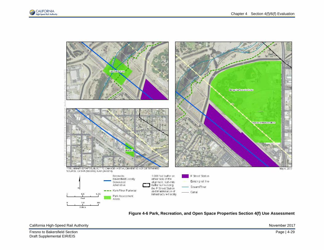
Use assessments for the park, recreation and open space properties under Section 4(f) as a result of the F-B LGA are described in this section. All Section 4(f) properties are shown in Figure 4-2, Figure 4-3, Figure 4-4, and Figure 4-5; however, only those three properties which would incur a use, or are close enough to the alignment alternative as to potentially incur proximity impacts (within 300 feet of F-B LGA alignment) are discussed below. Assessed parkland is shown in Figure 4-6.

Chapter 4 Section 4(f)/6(f) Evaluation
November 2017 California High-Speed Rail Authority
4-28 | Page Fresno to Bakersfield Section Draft Supplemental EIR/EIS
This page is left intentionally blank
Chapter 4 Section 4(f)/6(f) Evaluation
California High-Speed Rail Authority November 2017
Fresno to Bakersfield Section Page | 4-29 Draft Supplemental EIR/EIS
Figure 4-6 Park, Recreation, and Open Space Properties Section 4(f) Use Assessment
Chapter 4 Section 4(f)/6(f) Evaluation
November 2017 California High-Speed Rail Authority
4-30 | Page Fresno to Bakersfield Section Draft Supplemental EIR/EIS
This page is left intentionally blank
Chapter 4 Section 4(f)/6(f) Evaluation
California High-Speed Rail Authority November 2017
Fresno to Bakersfield Section Page | 4-31 Draft Supplemental EIR/EIS
Kern River Parkway Use Assessment
The F-B LGA would cross above the Kern River Parkway on an elevated guideway at a height of approximately 45 feet in an area that contains a pathway available for bikes and pedestrians and features that serve floodway purposes.
The high-speed rail (HSR) would be on an elevated structure spanning a portion of the parkway that is undeveloped except for the bike and pedestrian pathway. Footings for the columns that would support the guideway would be constructed within the Kern River Parkway, permanently impacting 0.96 acre, and the completed guideway would span the bike and pedestrian path. Except for the footings, no portion of the Kern River Parkway would be purchased by the Authority because the guideway would completely span the property and the park underneath the elevated guideway would remain available for park use consistent with the Authority’s policy on “Access Control for High-Speed Rail Right-of-Way and Facilities” (Parsons Brinckerhoff 2013). However, the Authority would have to negotiate and obtain a permanent 170-foot-wide maintenance easement from the City of Bakersfield so that the elevated guideway and track could be appropriately maintained during operation.
As discussed in Section 3.16, Aesthetics, and Visual Resources, the introduction of an elevated viaduct and HSR station visible from the Kern River Parkway would reduce the intactness of the visual environment, causing a decline in visual quality. However, because of the existing visual setting of the parkway (including an adjacent highway crossing and railroad crossing) and the types of uses at this portion of the resource (i.e., bicycle and pedestrian travel), the visual impacts would not substantially impair the attributes that qualify the facility for protection under Section 4(f).
As discussed in Section 3.4, Noise and Vibration, noise impacts due to operation of the HSR would result in a moderate increase in noise levels (from 56 A-weighted decibel [dBA] equivalent continuous sound level [Leq] to 63 dBA Leq ) with implementation of a 14-foot-high sound wall. The portion of the parkway in the study area is characterized by multiple noise-generating uses, including highways and railroads in the immediate vicinity of the project. The operation of the HSR would not substantially and adversely impact the normal use of the parkway because noise from the operations would be temporary (i.e., HSR noise would only be experienced when the trains pass through this area). Because of the existing levels of ambient noise, the types of uses accommodated, and considering the inclusion of the applicable mitigation measures, the moderate increase in noise levels would not substantially impair the attributes that qualify the facility for protection under Section 4(f).
As described above, the impacts on the Kern River Parkway that would result from the footing installation and the maintenance easement (for activities such as drain cleaning, litter removal, and inspection) would be minor in nature and would not adversely affect the activities, features, or attributes that qualify the resource for protection under Section 4(f). Based on the information gathered to date, FRA’s preliminary finding is that the F-B LGA Alternative will have a de mimimis impact on the Kern River Parkway in Bakersfield. The Authority and FRA have begun conversations with the City of Bakersfield Department of Recreation and Parks with regard to the characterization of effects of the project in the context of this Section 4(f) evaluation, consistent with 49 U.S.C. 303(d)(3)(B). As part of ongoing coordination with the City of Bakersfield, the FRA and the Authority will continue discussions and identification of opportunities to reduce impacts, such as minimizing the vertical clearance. FRA invites comment on its preliminary de minimis finding during the public review and comment period for the Draft Supplemental EIR/EIS.
Metropolitan Recreation Center
The F-B LGA would not acquire land from the Metropolitan Recreation Center and, therefore, would not result in a permanent or temporary use of this park.
As discussed in Section 3.4, Noise and Vibration, noise impacts due to operation of the HSR would result in a moderate increase in noise levels (from 48 dBA Leq to 60 dBA Leq ) with implementation of a 14-foot-high sound wall. The portion of the park in the study area is characterized by multiple noise-generating uses, including highways and railroads in between the park and the project. The operation of the HSR would not substantially and adversely impact the
Chapter 4 Section 4(f)/6(f) Evaluation
November 2017 California High-Speed Rail Authority
4-32 | Page Fresno to Bakersfield Section Draft Supplemental EIR/EIS
normal use of the park because noise from the operations would be temporary (i.e., HSR noise would only be experienced when the trains pass through this area). Because of the existing levels of ambient noise, the types of uses accommodated, and considering the inclusion of the applicable mitigation measures (N&V-MM #3 in Section 3.4 of this Draft Supplemental EIR/EIS), the moderate increase in noise levels would not substantially impair the attributes that qualify the facility for protection under Section 4(f). The presence of the Bakersfield F Street Station under the F-B LGA would change views from within the Metropolitan Recreation Area due to the proximity of the station to the west/southwest boundary of the park. Views of Kern River, located to the west/northwest of the Metropolitan Recreation Area, would not be blocked by the project. Views to the north and east from the park area would also remain unobstructed. The F-B LGA would therefore not degrade the existing visual character or quality of the site and its surroundings, and potential impacts to visual character would not substantially impair the attributes that qualify the facility for protection under Section 4(f).
Kern County Museum and Park
The F-B LGA would not acquire land from the Kern County Museum and Park and, therefore, would not result in a permanent or temporary use of this park. As discussed in Section 3.4, Noise and Vibration, noise impacts due to operation of the HSR would result in a moderate increase in noise levels (from 48 dBA Leq to 60 dBA Leq ) with implementation of a 14-foot-high sound wall. The portion of the park in the study area is characterized by multiple noise-generating uses, including highways and railroads in between the park and the project. The operation of the HSR would not substantially and adversely impact the normal use of the park because noise from the operations would be temporary (i.e., HSR noise would only be experienced when the trains pass through this area). Because of the existing levels of ambient noise, the types of uses accommodated, and considering the inclusion of the applicable mitigation measures (N&V-MM #3 in Section 3.4 of this Draft Supplemental EIR/EIS), the moderate increase in noise levels would not substantially impair the attributes that qualify the facility for protection under Section 4(f). The presence of the Bakersfield F Street Station under the F-B LGA would change views from within the Kern County Museum and Park area due to the proximity of the station to the west of the park. Views of Kern River, located to the northwest of the Kern County Museum and Park area, would not be blocked by the project. Views to the north and east from the park area would also remain unobstructed. The F-B LGA would therefore not degrade the existing visual character or quality of the site and its surroundings, and potential impacts to visual character would not substantially impair the attributes that qualify the facility for protection under Section 4(f).
Weill Park Use Assessment
The F-B LGA would pass over Weill Park on an elevated guideway at a height of approximately 75 feet in an area that contains open grassy areas. Footings for the columns that would support the guideway would be constructed within Weill Park and would permanently impact 0.07 acre. Except for the footings, no portion of Weill Park would be purchased by the Authority because the guideway would completely span the property and the park underneath the elevated guideway would remain available for park use consistent with the Authority’s policy on “Access Control for High-Speed Rail Right-of-Way and Facilities” (Parsons Brinckerhoff 2013). However, the Authority would have to negotiate and obtain a permanent 80-foot-wide maintenance easement (consisting of a 15-foot easement on either side of a 50-foot permanent right-of-way take) from the City of Bakersfield so that the elevated guideway and track could be appropriately maintained during operation. Construction activities would require temporary closure of the park for approximately three to six months. After completion of construction activities, Weill Park would be reopened to the public. The temporary construction closure would meet the requirements of a Section 4(f) temporary occupancy.
As discussed in Section 3.4 Noise and Vibration, noise impacts due to operation of the HSR would result in a minor increase in noise levels (from 62 dBA Leq to 65 dBA Leq ) with implementation of a 14-foot-high sound wall. The park is characterized by multiple noise-
Chapter 4 Section 4(f)/6(f) Evaluation
California High-Speed Rail Authority November 2017
Fresno to Bakersfield Section Page | 4-33 Draft Supplemental EIR/EIS
generating uses, including nearby industrial uses and roadways. The operation of the HSR would not substantially and adversely impact the normal use of the parkway because noise from the operations would be temporary (i.e., HSR noise would only be experienced when the trains pass through this area). Because of the existing levels of ambient noise, the types of uses accommodated, and considering the inclusion of the applicable mitigation measures, the moderate increase in noise levels would not substantially impair the attributes that qualify the facility for protection under Section 4(f).
As discussed in Section 3.16 Aesthetics and Visual Resources, the area surrounding Weill Park, the Central Bakersfield Landscape Unit is defined primarily by low to moderate views. Weill Park itself is surrounded by a low quality viewscape environment. From Weill Park, views to the north are of James Street and the UPRR, to the east are light industrial facilities, to the west are industrial facilities (a recycling center), and to the south SR 99 and associated ramp structures. As such, visual impacts from the F-B LGA are anticipated to be low.
As described above, the impacts on Weill Park that would result from the footing installation and the maintenance easement (e.g., drain cleaning, litter removal, and inspection) would be minor in nature and would not adversely affect the activities, features, or attributes that qualify the resource for protection under Section 4(f).
Based on the information gathered to date, FRA’s preliminary finding is that the F-B LGA could result in a de minimis impact on Weill Park in Bakersfield. The Authority and FRA have begun conversations with the City of Bakersfield Department of Recreation and Parks with regard to the characterization of effects of the project in the context of this Section 4(f) evaluation, consistent with 49 U.S.C. 303(d)(3)(B). As part of ongoing coordination with the City of Bakersfield, the FRA and the Authority will continue discussions and identification of opportunities to reduce impacts created by the construction of the viaduct within the park limits. FRA invites comment on its proposed de minimis impact determination during the public review and comment period for the Draft Supplemental EIR/EIS.
4.3.2.2 Cultural Resources Section 4(f) Use Assessment Use assessments for the cultural resources under Section 4(f) as a result of the F-B LGA are described in this section. All Section 4(f) properties are shown in Figure 4-2 through Figure 4-5. There would be no use under Section 4(f) of any of the historic properties listed in Table 4-3. Figure 4-7, Figure 4-10, and Figure 4-11 show the historic properties at a close scale.
Santa Fe Passenger and Freight Depot Use Assessment The F-B LGA would pass the Santa Fe Passenger and Freight Depot (NRHP Criterion C), as shown in Figure 4-7, at a distance of 30 feet. The F-B LGA would cause indirect adverse effects on this historic property from the introduction of visual features that would diminish the integrity of the historic property and would cause a substantial adverse change to the immediate surroundings of the historical resource. The project proposes to raise the BNSF track, which will degrade the historic layout and relationship this railroad depot has to the existing at-grade track. Although this building was moved in the past, it was listed in the NRHP based on the fact that it is still adjacent to and oriented toward the railroad. By raising the track on fill, the project will introduce visual features that would diminish the integrity of the resource because it will no longer be able to convey the significance it has in association with the railroad. The construction and operation of the F-B LGA will not result in a direct adverse effect to the Santa Fe Passenger and Freight Depot because they would not result in relocation or alteration of this property. The construction of the proposed project would not cause indirect adverse noise effects on the Santa Fe Passenger and Freight Depot. Associated noise from the proposed project would result; however, the Santa Fe Passenger and Freight Depot was designed and used to serve a rail system that often emitted high levels of noise. It does not derive its NRHP significance from being located in a quiet setting. Furthermore, less operational noise would result from the track being raised. Damage to the property from vibration or construction activities will be avoided by implementation of measures presented Section 3.17.5.
Chapter 4 Section 4(f)/6(f) Evaluation
November 2017 California High-Speed Rail Authority
4-34 | Page Fresno to Bakersfield Section Draft Supplemental EIR/EIS
This page intentionally left blank
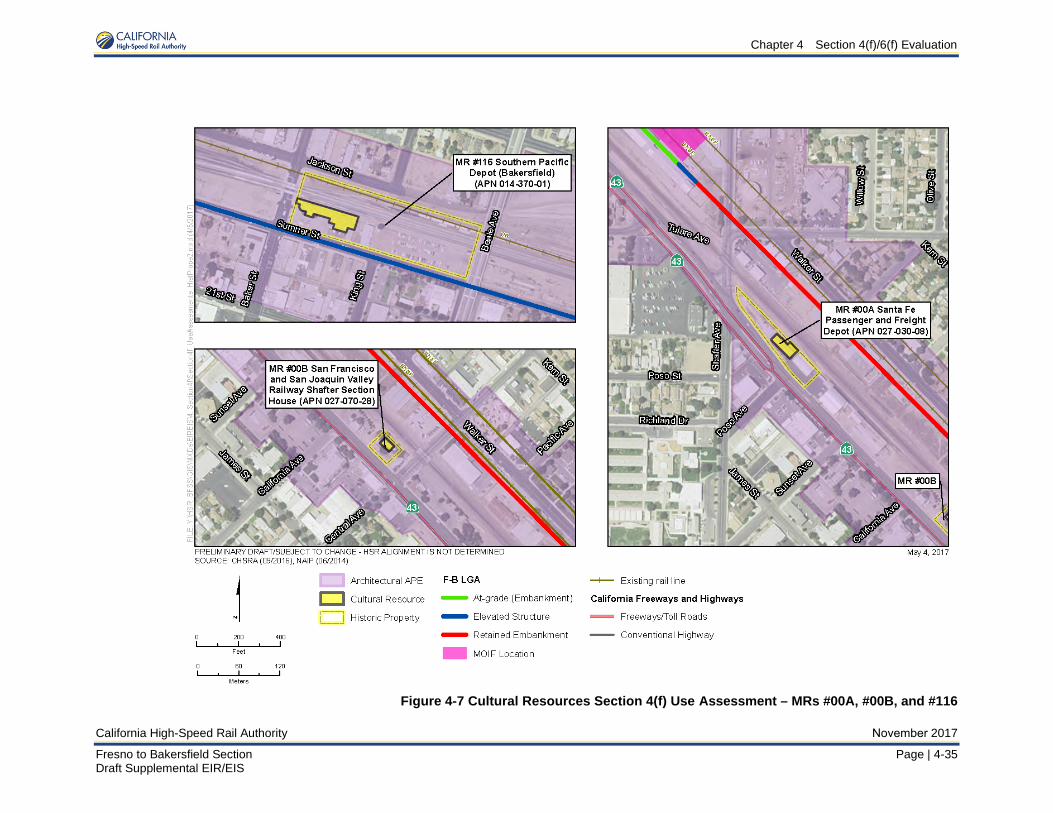
Chapter 4 Section 4(f)/6(f) Evaluation
California High-Speed Rail Authority
Figure 4-7 Cultural Resources Section 4(f) Use Assessment – MRs #00A, #00B, and #116
November 2017
Fresno to Bakersfield Section Page | 4-35 Draft Supplemental EIR/EIS

Chapter 4 Section 4(f)/6(f) Evaluation
November 2017 California High-Speed Rail Authority
4-36 | Page Fresno to Bakersfield Section Draft Supplemental EIR/EIS
This page intentionally left blank
Chapter 4 Section 4(f)/6(f) Evaluation
California High-Speed Rail Authority November 2017
Fresno to Bakersfield Section Page | 4-37 Draft Supplemental EIR/EIS
Although the visual intrusion of the F-B LGA would diminish the Santa Fe Passenger and Freight Depot’s integrity of association, it will not reach the threshold of substantial impairment of the attributes (NRHP Criterion C) that cause the depot to be eligible for the NRHP as it would not materially impair the building’s key architecturally significant characteristics such as its massing, plan, wood siding, hip roof, exterior porch, and fenestration. The building would still retain its historic fabric and use features. As such, no permanent or constructive use of this Section 4(f) property is anticipated to occur. San Francisco & San Joaquin Valley Railway Shafter Section House Use Assessment
The F-B LGA would pass the San Francisco & San Joaquin Valley Railway Shafter Section House (NRHP Criterion A, C), as shown in Figure 4-7. The F-B LGA would cause indirect adverse effects from the introduction of visual features that would diminish the integrity of the historic property and would cause adverse change to the immediate surroundings of the historical resource. The project proposes to raise the BNSF track, which will compromise the historic layout and relationship this resource has to the existing at-grade track. By raising the track on fill, the resource will no longer be able to convey the significance it has in association with the railroad. The construction and operation of the F-B LGA will not result in a direct adverse effect to the San Francisco & San Joaquin Valley Railroad Railway Shafter Section House. Damage to the property from vibration or construction activities will be avoided by implementation of measures presented Section 3.17.5. Construction activities for certain project components would not result in relocation or alteration of this property. The anticipated noise from operation of the HSR would not cause indirect adverse effects to this residential property. Construction of the raised BNSF railway would decrease the operational noise of both the HSR and BNSF.
Although the visual intrusion of the F-B LGA would diminish the San Francisco & San Joaquin Valley Railway Shafter Section House’s integrity of association, it will not reach the threshold of substantial impairment of the attributes (NRHP Criterion A, C) that cause the house to be eligible for the NRHP as it would not materially impair the residence’s key architecturally significant characteristics such as its horizontal wood siding, double-hung wood windows with wide wood casing, recessed porch with square supports and capitals facing the railroad tracks, diamond-pattern tin-shingle roofing, and wide eaves with exposed rafter tails. The house will still retain its historic fabric and use features, as well as its integrity of design, materials, workmanship,] and location. As such, no permanent or constructive use of this Section 4(f) property is anticipated to occur.
Friant-Kern Canal Use Assessment
The F-B LGA would pass directly over the Friant-Kern Canal (NRHP Criterion A), as shown in Figure 4-8.
The Friant-Kern Canal will not be adversely affected during construction activities of the F-B LGA. The construction and operation of the proposed project would not cause a direct adverse effect on the Friant-Kern Canal because it would not result in the removal or alteration of the property.
The boundary of this historic property is limited to the area immediately adjacent to the lined canal (between the tops of its banks) and the Kern River Spillway structures and rock revetment area at the end of the canal. The bridge proposed to carry the HSR over the Friant-Kern Canal would be constructed outside of the surficial boundary and would span the historic property. Damage to the property is not anticipated; measures presented Section 3.17.5 will ensure this property is protected from inadvertent damage that may occur during project construction.
The area surrounding the Friant-Kern Canal has many noncontributing bridges (farm, county, state, and railroad bridges), power and utility crossings, cattle guards, historic wood trapezoidal canal and Central Valley Project signs, fencing, and levees cross the canal, none of which affect any character-defining features of the property (NRHP Criterion A). The setting of the Friant-Kern Canal will not be adversely affected by the introduction of an additional bridge structure spanning it. As such, no permanent or constructive use of this Section 4(f) property is anticipated to occur.

Chapter 4 Section 4(f)/6(f) Evaluation
November 2017 California High-Speed Rail Authority
4-38 | Page Fresno to Bakersfield Section Draft Supplemental EIR/EIS
This page intentionally left blank

Chapter 4 Section 4(f)/6(f) Evaluation
California High-Speed Rail Authority November 2017
Fresno to Bakersfield Section Page | 4-39 Draft Supplemental EIR/EIS
Figure 4-8 Cultural Resources Section 4(f) Use Assessment – MRs #00C and #025

Chapter 4 Section 4(f)/6(f) Evaluation
November 2017 California High-Speed Rail Authority
4-40 | Page Fresno to Bakersfield Section Draft Supplemental EIR/EIS
This page intentionally left blank
Chapter 4 Section 4(f)/6(f) Evaluation
California High-Speed Rail Authority November 2017
Fresno to Bakersfield Section Page | 4-41 Draft Supplemental EIR/EIS
San Joaquin Compress and Warehouse Use Assessment While the F-B LGA would cross the parcel, the structure will pass the closest contributing building to the San Joaquin Compress and Warehouse (NRHP Criterion A) property, as shown in Figure 4-8. The contributing buildings to this property will not be adversely affected; however, three non-contributing elements of the complex will be removed for this project. Removal of the non-contributing buildings (Warehouse 8 and Storage/Utility Buildings 9 and 10) will not affect the character-defining features or integrity of the remaining contributing elements of this property. The HSR would be visible along the southwest side of the property; however, this industrial property was originally constructed at a heavy rail junction and its layout configured on either side of one of the rail lines. The property has also been adjacent to a major highway since original Golden State Highway (later U.S. 99) was constructed in the 1930s, during the period of significance of the compress plant. The addition of the proposed elevated structure would not, therefore, introduce a visual element that diminishes the integrity of the industrial complex. There would be no anticipated adverse effects from construction or operational noise as the San Joaquin Compress and Warehouse Company has always been located in transportation and industrial area does not derive its NRHP significance form being located in a quiet setting. Construction of the F-B LGA will not adversely affect the San Joaquin Compress and Warehouse during construction activities. Damage to the property is not anticipated; measures presented Section 3.17.5 will ensure this property is protected from vibration damage that may occur during project construction. As such, no permanent or constructive use of this Section 4(f) property is anticipated to occur. The removal of the non-contributing buildings would not alter the integrity (NRHP Criterion A) of the property. The property is in an active multi-modal transportation corridor so the setting of the property will not be adversely affected by the introduction of an additional railroad feature. Therefore, no permanent or constructive use of this Section 4(f) property is anticipated to occur.
Father Garces Statue Use Assessment Widening of Golden State Avenue will occur within 40 feet of the Statue of Father Garces (NRHP Criterion C) as shown on Figure 4-9. Construction of the F-B LGA will not adversely affect the Statue of Father Garces during construction activities. Construction activities associated with the widening of SR 204 would not result in relocation or alteration of this resource. The proposed project would not result in an indirect adverse effect on the Statue of Father Garces from the introduction of visual, vibration, or noise elements that would diminish the integrity of the historic property. While the elevated rail line and improvements to the SR 204 viaduct will be visible from the historic property, the statue has always been located adjacent to major transportation structures. The statue was placed in the original traffic circle in the 1930s, and then relocated within the circle to accommodate a previous viaduct in the 1950s. It is recognized as a historically significant object and its proximity to the proposed project elements will not constitute any adverse effect because the project will not diminish any aspect of its integrity, nor would the proposed project materially alter the setting or views of or from this historic property. Damage to the property will be avoided because avoidance measures presented Section 3.17.5 will ensure this property is protected from inadvertent damage that may occur during project construction. The visual intrusion of the F-B LGA would not impair the attributes (NRHP Criterion C) that cause the property to be eligible for the NRHP. The setting has already been significantly altered and is not considered a character-defining feature of the property. As such, no permanent or constructive use of this Section 4(f) property is anticipated to occur. Figure 4-9 shows the Statue’s proximity to the F-B LGA.
Republic Supply Company (Golden Empire Gleaners) Use Assessment The F-B LGA would intersect the Republic Supply Company (Golden Empire Gleaners) (NRHP Criterion C), as shown in Figure 4-9. Columns are proposed directly on this parcel that will support a viaduct that will pass directly over the property. Due to its eligibility under Criterion C, the historic property boundary is the footprint of the building (as expanded through 1946) and the entrance plaza. The later additions to the parcel, such as the central kitchen, equipment shelter canopy, and small additions to the main building, do not contribute to the property; nor does the
Chapter 4 Section 4(f)/6(f) Evaluation
November 2017 California High-Speed Rail Authority
4-42 | Page Fresno to Bakersfield Section Draft Supplemental EIR/EIS
modern parking lot where the columns are proposed. The parcel is not the same as the historic property boundary and, as a result, the incorporation into the transportation project is not a use of this Section 4(f) property. Although the viaduct and columns will not affect access to this property, the modern structure will be a visually dominating, massive feature that will alter the setting of this property. This resource would be indirectly affected by construction of the F-B LGA from the introduction of unavoidable visual features that would diminish the integrity of the historic property and would cause a substantial adverse change to the immediate surroundings of the historical resource. The construction and operation of the proposed project will not result in a direct adverse effect to the Republic Supply Company. Construction activities for certain project components would be directly over the historic property; however, they would not result in relocation or deliberate alteration of this building. Damage to the property from vibration or construction activities will be avoided by implementation of measures presented Section 3.17.5. While the visual intrusion of the F-B LGA is significant, it would not reach the threshold of substantial impairment of the attributes (NRHP Criterion C) that cause the property to be eligible for the NRHP as it would still retain its historic design and fabric. As such, no permanent or constructive use of this Section 4(f) property is anticipated to occur. Division of Forestry Office Use Assessment
The F-B LGA would pass the Division of Forestry (NRHP Criterion A, C), as shown in Figure 4-9. The construction and operation of the proposed project would not cause a direct adverse effect on the Division of Forestry Services Office because the building will not be physically altered or removed from its location. There would be no anticipated adverse effects through the introduction of noise because this project activity would not diminish the integrity of this property, which has been located in a transportation and industrial area since its construction. The proposed elevated rail line would be visible from this historic building from most vantage points, but the building was originally constructed within a maintenance yard and shop complex and located between an at-grade freight railroad and a busy highway. The elevated HSR structure will introduce a new visual element, but its presence does not diminish the integrity of the historic building, which has always been located near two major transportation corridors. Damage to the property will be avoided because measures presented Section 3.17.5 will ensure this property is protected from vibration damage that may occur during project construction. The historic property boundary is limited to the building’s footprint. The setting has already been significantly altered and is not considered a character-defining feature of the property. As such, no permanent or constructive use of this Section 4(f) property is anticipated to occur.
Kern County Land Company Warehouse Use Assessment
The F-B LGA would pass the Kern County Land Company Warehouse (NRHP Criterion A, C), as shown in Figure 4-9. This resource would be indirectly affected by construction of the F-B LGA. The F-B LGA would cause indirect adverse effects on this historic property from the introduction of visual features that would diminish the integrity of the historic property. Columns are proposed directly on this parcel that will support a viaduct that will pass over the property. Although the viaduct and columns will not affect access to this property, the modern structure will be a visually dominating, massive feature that will alter the setting of this property. The introduction of a new transportation feature of this size and scale into the building’s setting is an indirect adverse effect because the building can no longer be viewed without this visual intrusion. The new structure will cast shadows on the primary elevation of the building, which also diminishes the integrity of feeling, and constitutes an indirect adverse effect. The construction and operation of the proposed project will not result in a direct adverse effect to the Kern County Land Company Warehouse. Construction activities for certain project components would be immediately adjacent to this property but would not result in relocation or alteration of this building. There would be no anticipated adverse effects from construction or operational noise because the Kern County Land Company Warehouse does not derive its NRHP significance form being located in a quiet setting and the introduction of noise from this project activity would not diminish its integrity. Damage to the property from vibration or construction activities will be avoided by implementation of measures presented Section 3.17.5.
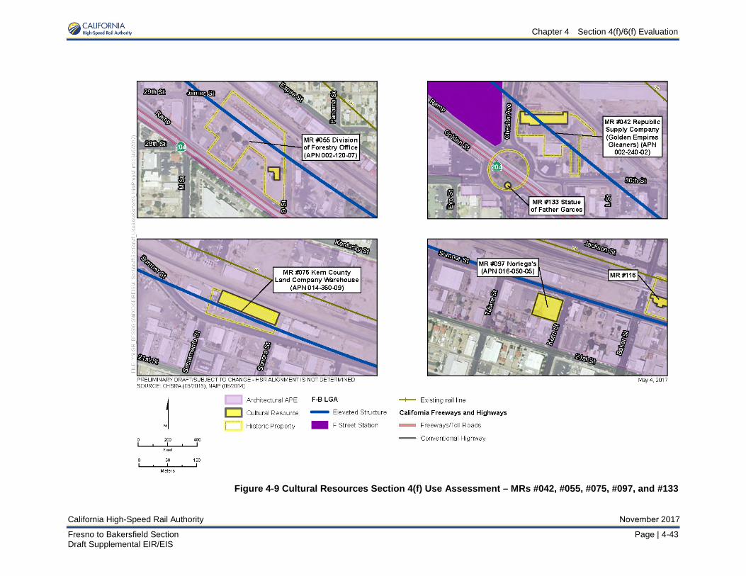
Chapter 4 Section 4(f)/6(f) Evaluation
California High-Speed Rail Authority November 2017
Fresno to Bakersfield Section Page | 4-43 Draft Supplemental EIR/EIS
Figure 4-9 Cultural Resources Section 4(f) Use Assessment – MRs #042, #055, #075, #097, and #133

Chapter 4 Section 4(f)/6(f) Evaluation
November 2017 California High-Speed Rail Authority
4-44 | Page Fresno to Bakersfield Section Draft Supplemental EIR/EIS
This page intentionally left blank
Chapter 4 Section 4(f)/6(f) Evaluation
California High-Speed Rail Authority November 2017
Fresno to Bakersfield Section Page | 4-45 Draft Supplemental EIR/EIS
While the visual intrusion of the F-B LGA is significant, it would not reach the threshold of substantial impairment of the attributes (NRHP Criterion A, C) that cause the property to be eligible for the NRHP as it would still retain its historic design, fabric, and compatible use. As such, no permanent or constructive use of this Section 4(f) property is anticipated to occur. Noriega’s Use Assessment
The F-B LGA would pass Noreiga’s (NRHP Criterion A, B, C), as shown in Figure 4-9. Noriega’s will not be adversely affected from construction of the F-B LGA. The construction and operation of the proposed project will not result in a direct adverse effect to Noriega’s because it would not result in relocation or alteration of this property. Damage to the property from vibration or construction activities will be avoided by implementation of measures presented Section 3.17.5. Although the operation of the proposed project would cause a moderate level of noise to this historic property, the Southern Pacific Railroad line located across Sumner Street from Noriega’s and predates the history property. Throughout its history, the setting of Noriega’s has included noise from the rail corridor and nearby industrial and semi-industrial activities. Consequently, there would be no anticipated adverse effects from construction or operational noise as Noriega’s does not derive its NRHP significance from being located in a quiet setting. The proposed project would not cause an indirect adverse effect on this historic property from the visual introduction of an elevated rail line in front of the buildings. The rail would be on viaduct within Sumner Street in front (north) of Noriega’s, and would be visible from the windows and main entrance on the northern façade; however, Noriega’s gains its central historic importance under NRHP Criterion A/CRHR Criterion 1 and as a traditional cultural property from interior spaces that serve as a social, recreational, and traditional cultural gathering space. Similarly, under NRHP Criterion B/CRHR Criterion 2, Noriega’s significance lies in how Grace Elizalde ran the property as a restaurant, boarding house, and social gathering place. Nothing about the introduction of new visual element into the setting – which is not a character-defining feature of this property – prevents it from conveying its significance as a social gathering space for Bakersfield’s Basque community that Grace Elizalde successfully operated. Noriega’s is also significant under NRHP Criterion C/CRHR Criterion 3 as a property type that includes the boarding house, restaurant, and ball court. It is not significant under those criteria for the aesthetic values of its architectural design, but rather as a unique type of property built and used by members of the local Basque community. Introduction of this new visual element does not prevent the complex from conveying this significance to an observer. No part of the proposed project impedes an observer’s gaze from viewing the complex, or understanding it as a unified whole. The solid two-story front wall of the ball court would block views of the elevated rail line from within the court. The introduction of a new, elevated rail in front of Noriega’s would not adversely alter the viewshed or setting of this property, which is not character-defining, in a manner that would diminish its integrity or its ability to convey its significance, and it would continue to serve as a traditional cultural property. During the Section 106 process, an assessment was made to consider the existence of a historic Basque district; however, it was found that the area had been significantly altered and there was no cohesive collection of buildings and structures. The property will not be physically touched by the project and the setting has already been significantly altered. Noriega’s has always been near a noisy rail corridor and industrial area. Consequently the audible intrusion of the F-B LGA will not impair its current historic use (NRHP Criterion A, B, C) as a TCP for the Basque community. As such, no permanent or constructive use of this Section 4(f) property is anticipated to occur. Amestoy Hotel (aka Narducci’s Restaurant) Use Assessment
The F-B LGA would pass the Amestoy Hotel (NRHP Criterion A), as shown in Figure 4-10. The Amestoy Hotel would not be adversely affected by construction of the F-B LGA because it is too distant from the F-B LGA to be affected physically or visually. The property will not be affected by the introduction of visual features because it is located over 200 feet from the elevated rail line, is not oriented toward the proposed structure, and is buffered by existing buildings and vegetation. The construction and operation of the proposed project would not result in direct adverse effects on the Amestoy Hotel because they would not result in the physical demolition, destruction, relocation, or alteration of this resource. There would be no anticipated adverse effects from construction or operational noise as the Amestoy Hotel does not derive its NRHP significance
Chapter 4 Section 4(f)/6(f) Evaluation
November 2017 California High-Speed Rail Authority
4-46 | Page Fresno to Bakersfield Section Draft Supplemental EIR/EIS
form being located in a quiet setting. As such, no permanent or constructive use of this Section 4(f) property is anticipated to occur.
Southern Pacific Depot Use Assessment
The F-B LGA would pass the Southern Pacific Depot (NRHP Criterion A, C) as shown in Figure 4-7 and Figure 4-9. The construction and operation of the proposed project will not result in a direct adverse effect to the former Southern Pacific Depot because construction activities for certain project components would not result in its relocation or alteration. The proposed elevated rail line would be visible from this historic building’s western, eastern, and southern façades; however, the front of the property is its northern façade and views toward the railroad, which contribute to the historical setting and significance of this building, would not be compromised by proposed construction. The setting behind the building is not significant and has been compromised over the years with the introduction of modern elements. There would be no anticipated adverse effects from construction or operational noise as the Southern Pacific Depot is located in a noisy transportation and industrial area and does not derive its NRHP significance form being located in a quiet setting. Damage to the property will not occur because measures presented Section 3.17.5 will ensure this property is protected from vibration damage that may occur during project construction.
The historic property boundary is limited to the building’s footprint, minus the two additions. The F-B LGA will not physically impact the building. The setting has historically been associated with the railroad (NRHP Criterion A, B, C), yet has also been significantly altered over the course of the building’s existence and is not considered a character-defining feature of the property. As such, no permanent or constructive use of this Section 4(f) property is anticipated to occur.
Fire Station Number Two
The F-B LGA would pass Fire Station Number Two (NRHP Criterion A, C), as shown in Figure 4-10. Fire Station Number Two would not be adversely affected by construction of the F-B LGA because it is too distant from the F-B LGA to be affected physically or visually. As such, no permanent or constructive use of this Section 4(f) property is anticipated to occur.
Folk Victorian Residence
The F-B LGA would pass the Folk Victorian Residence (NRHP Criterion C), as shown in Figure 4-10. The Folk Victorian Residence would not be adversely affected by construction of the F-B LGA because it is too distant from the F-B LGA to be affected physically or visually. As such, no permanent or constructive use of this Section 4(f) property is anticipated to occur. State Route 204/Golden State Avenue
The F-B LGA would pass portions of State Route 204/Golden State Avenue (NRHP Criterion A), as shown in Figure 4-11. The majority of SR 204/Golden State Avenue within the APE does not have historic integrity. However, two segments within the APE do retain their historic integrity and contribute to the significance of SR 204/Golden State Avenue, including the southern segment from Kern Island Canal to 22nd Street and the northern segment from the south end of Stine Canal Bridge to the Airport Drive interchange. The project proposes some alterations to the Stine Canal Bridge, a contributing element of SR 204 that retains historic integrity. The alterations include widening the bridge. The original railings would be remounted on the top surface of the new safety barrier, and the new columns supporting the deck would be compatible with the massing, size, and scale of the existing columns. The fluting design of the new substructure columns would be similar to, but differentiated from, the original design. The project would have no direct adverse effects on the historic property as a result of the physical destruction, damage, or alteration to the contributing element of the historic property because the proposed alterations meet the USSOI Standards for the Rehabilitation of Historic Properties.
As such, no permanent or constructive use of this Section 4(f) property is anticipated to occur.
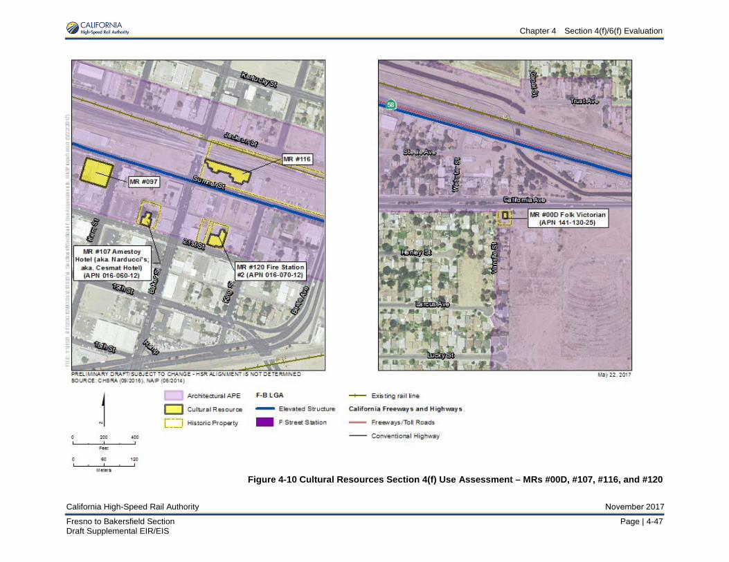
Chapter 4 Section 4(f)/6(f) Evaluation
California High-Speed Rail Authority November 2017
Fresno to Bakersfield Section Page | 4-47 Draft Supplemental EIR/EIS
Figure 4-10 Cultural Resources Section 4(f) Use Assessment – MRs #00D, #107, #116, and #120
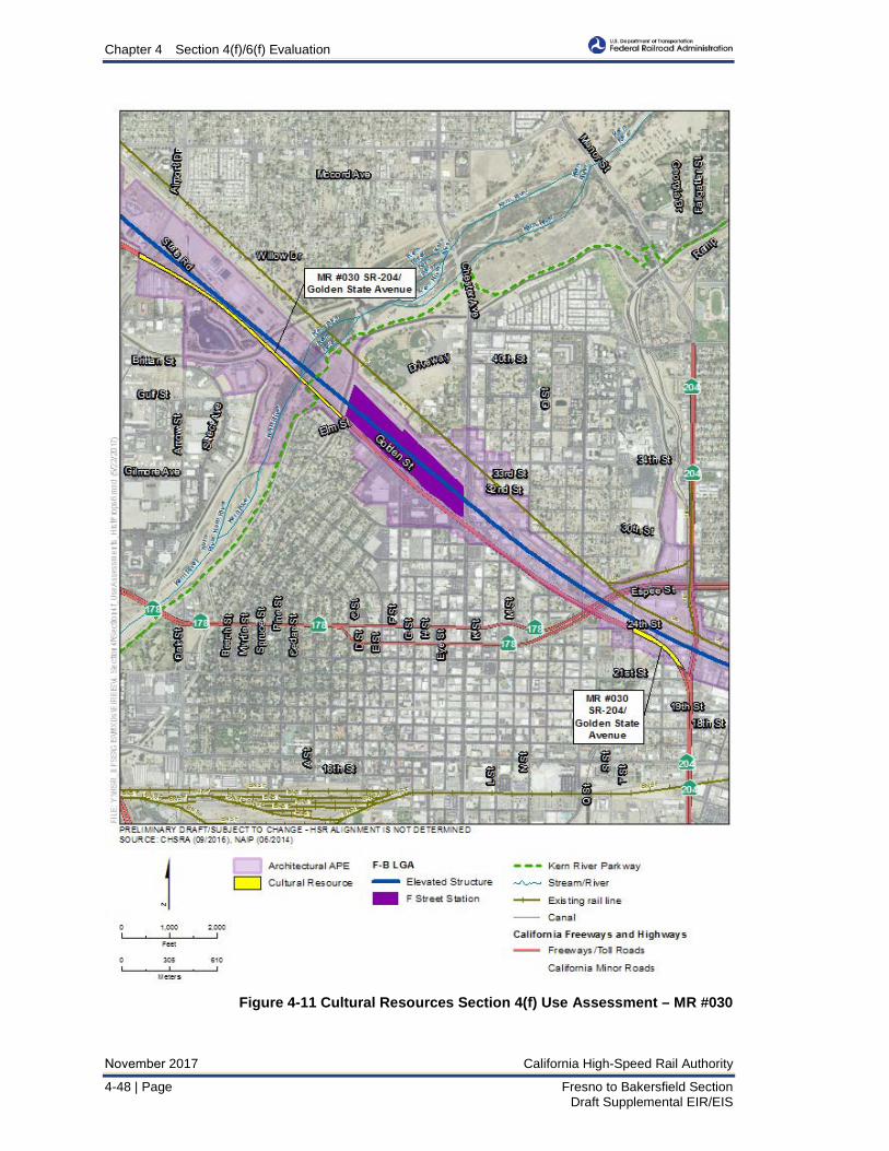
Chapter 4 Section 4(f)/6(f) Evaluation
November 2017 California High-Speed Rail Authority
4-48 | Page Fresno to Bakersfield Section Draft Supplemental EIR/EIS
Figure 4-11 Cultural Resources Section 4(f) Use Assessment – MR #030
Chapter 4 Section 4(f)/6(f) Evaluation
California High-Speed Rail Authority November 2017
Fresno to Bakersfield Section Page | 4-49 Draft Supplemental EIR/EIS
4.3.2.3 Section 6(f) Conversion Summary Although the Uplands of the Kern River Parkway (a Section 6(f) property) are located within the study area and within 300 feet of the F-B LGA footprint, the F-B LGA would not convert the property into a non-recreational use under Section 6(f).
4.4 Measures to Minimize Harm The Authority and FRA have identified measures to minimize harm that include measures that were taken during project planning to avoid or minimize impacts as well as mitigation and enhancement measures to compensate for unavoidable project impacts. These measures are consistent with the Program EIR/EIS documents that would be applicable to the Fresno to Bakersfield Section Final EIR/EIS and this Draft Supplemental EIR/EIS. During project design and construction, the Authority will ensure that the measures detailed below are implemented to minimize harm to Section 4(f)/6(f) properties.
The FRA, the federal lead agency under the National Environmental Policy Act (NEPA), and the Authority continue to work to develop measures to avoid, minimize, and evaluate potential effects associated with the F-B LGA, in consultation with the appropriate owners/operators of the Section 4(f) resources. For example, as a result of a Settlement Agreement between the City of Bakersfield and the Authority, discussed in Section 4.3.1, as part of the design process to avoid or minimize Section 4(f) impacts, two modifications to the F-B LGA have been made in coordination with local agencies and include: 1) consideration of pier placements and spacing over Weill Park to minimize impacts, 2) consideration of the placement of the crossing over the Kern River Parkway and the height of the viaduct to minimize impacts.
4.4.1 Measures to Minimize Harm from the May 2014 Project The following measures to minimize harm were approved in the Fresno to Bakersfield Section Final EIR/EIS and are applicable to this section of the proposed alternatives (from Bakersfield to Shafter). A brief discussion is provided after each program-level avoidance and measure describing whether it is applicable to the F-B LGA.
4.4.2 F-B LGA Measures to Minimize Harm Measures to minimize harm include measures that were taken during project planning to avoid or minimize impacts as well as mitigation and enhancement measures to compensate for unavoidable project impacts. Table 4-4 lists the measures identified by the FRA and the Authority to minimize harm (including measures applicable to the May 2014 Project), as required by 49 U.S.C. Section 303(c)(2), which will be incorporated into the project to address the impacts of the alternative alignment. It should be noted that not all parts of the measures to minimize harm would be applicable to the F-B LGA (for example no Section 106 properties are affected by the F-B LGA and therefore measures to reduce Section 106 impacts are not applicable). Additionally, some mitigation measures below would act as minimization measures for the F-B LGA where mitigation is not required. The FRA and the Authority are continuing ongoing coordination, as appropriate, with these officials; during FRA’s consideration of its decision and during final design, additional measures may be agreed on to further reduce potential impacts on Section 4(f) properties.
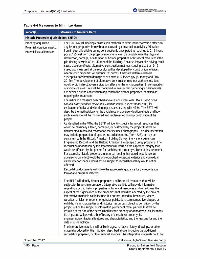
Chapter 4 Section 4(f)/6(f) Evaluation
November 2017 California High-Speed Rail Authority
4-50 | Page Fresno to Bakersfield Section Draft Supplemental EIR/EIS
Table 4-4 Measures to Minimize Harm
Impact(s) Measures to Minimize Harm Historic Properties (Jurisdiction: SHPO) Property acquisition Potential vibration impacts Potential visual intrusion
• The F-B LGA will develop construction methods to avoid indirect adverse effects toany historic properties from vibration caused by construction activities. Vibrationfrom impact pile-driving during construction is anticipated to reach up to 0.12 in/secppv at 135 feet from the project centerline, a level that could cause the physicaldestruction, damage, or alteration of historic properties or historical resources if thepile-driving is within 80 to 140 feet of the building. Because impact pile-driving couldcause adverse effects, alternative construction methods causing less than 0.12in/sec ppv measured at the receptor will be developed for construction activitiesnear historic properties or historical resources if they are determined to besusceptible to vibration damage at or above 0.12 in/sec ppv (Authority and FRA2012e). The development of alternative construction methods at these locationswould avoid indirect adverse vibration effects on historic properties. Implementationof avoidance measures will be monitored to ensure that damaging vibration levelsare avoided during construction adjacent to the historic properties identified asrequiring this treatment.The mitigation measure described above is consistent with FRA’s High-SpeedGround Transportation Noise and Vibration Impact Assessment (2005) forevaluation of noise and vibration impacts associated with HSRs. The BETP willdescribe the methodology for the avoidance of adverse vibration effects and howsuch avoidance will be monitored and implemented during construction of theproject.
• As identified in the MOA, the BETP will identify specific historical resources thatwould be physically altered, damaged, or destroyed by the project that will bedocumented in detailed recordation that includes photographs. This documentationmay include preparation of updated recordation forms (Form 523), or may beconsistent with the Historic American Building Survey, the Historic AmericanEngineering Record, and the Historic American Landscape Survey programs. Therecordation undertaken by this treatment will focus on the aspect of integrity thatwould be affected by the project for each historic property subject to this treatment.For example, historic properties in an urban setting that would experience anadverse visual effect would be photographed to capture exterior and contextualviews; interior spaces would not be subject to recordation if they would not beaffected.Recordation documents will follow the appropriate guidance for the recordationformat and program selected.
• The BETP will identify historic properties and historical resources that will besubject for historic interpretation. Interpretive exhibits will provide informationregarding specific historic properties or historical resources and will address theaspect of the significance of the properties that would be affected by the project.Interpretive materials could include, but are not limited to: brochures, videos,websites, articles, or reports for general publication, commemorative plaques orexhibits. Historic properties and historical resources subject to demolition by theproject will be the subject of informative permanent metal plaques that will beinstalled at the site of the demolished historic property or at nearby public locations.Each plaque will provide a brief history of the subject property, itsengineering/architectural features and characteristics, and the reasons for and thedate of its demolition.The interpretive materials will utilize images, narrative history, drawings, or othermaterial produced for the mitigation described above, including the additionalrecordation prepared, or other archival sources. The interpretive materials could be
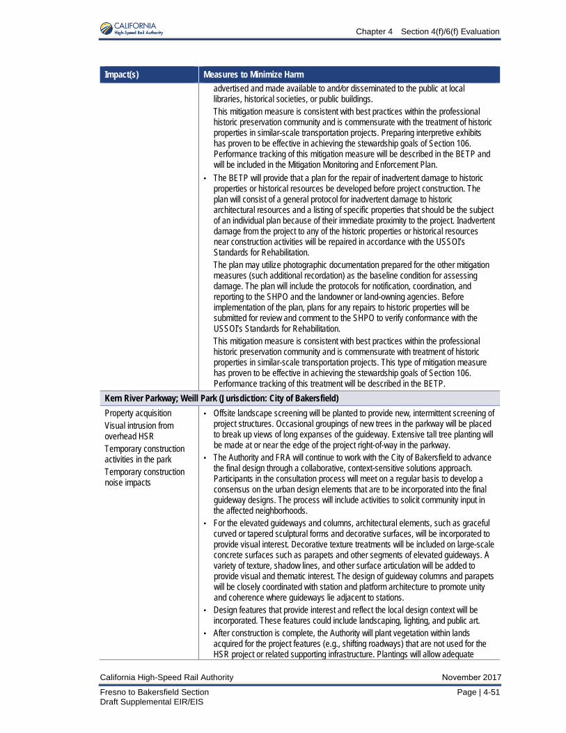
Chapter 4 Section 4(f)/6(f) Evaluation
California High-Speed Rail Authority November 2017
Fresno to Bakersfield Section Page | 4-51 Draft Supplemental EIR/EIS
Impact(s) Measures to Minimize Harm advertised and made available to and/or disseminated to the public at local libraries, historical societies, or public buildings. This mitigation measure is consistent with best practices within the professional historic preservation community and is commensurate with the treatment of historic properties in similar-scale transportation projects. Preparing interpretive exhibits has proven to be effective in achieving the stewardship goals of Section 106. Performance tracking of this mitigation measure will be described in the BETP and will be included in the Mitigation Monitoring and Enforcement Plan.
• The BETP will provide that a plan for the repair of inadvertent damage to historicproperties or historical resources be developed before project construction. Theplan will consist of a general protocol for inadvertent damage to historicarchitectural resources and a listing of specific properties that should be the subjectof an individual plan because of their immediate proximity to the project. Inadvertentdamage from the project to any of the historic properties or historical resourcesnear construction activities will be repaired in accordance with the USSOI’sStandards for Rehabilitation.The plan may utilize photographic documentation prepared for the other mitigationmeasures (such additional recordation) as the baseline condition for assessingdamage. The plan will include the protocols for notification, coordination, andreporting to the SHPO and the landowner or land-owning agencies. Beforeimplementation of the plan, plans for any repairs to historic properties will besubmitted for review and comment to the SHPO to verify conformance with theUSSOI’s Standards for Rehabilitation.This mitigation measure is consistent with best practices within the professionalhistoric preservation community and is commensurate with treatment of historicproperties in similar-scale transportation projects. This type of mitigation measurehas proven to be effective in achieving the stewardship goals of Section 106.Performance tracking of this treatment will be described in the BETP.
Kern River Parkway; Weill Park (Jurisdiction: City of Bakersfield) Property acquisition Visual intrusion from overhead HSR Temporary construction activities in the park Temporary construction noise impacts
• Offsite landscape screening will be planted to provide new, intermittent screening ofproject structures. Occasional groupings of new trees in the parkway will be placedto break up views of long expanses of the guideway. Extensive tall tree planting willbe made at or near the edge of the project right-of-way in the parkway.
• The Authority and FRA will continue to work with the City of Bakersfield to advancethe final design through a collaborative, context-sensitive solutions approach.Participants in the consultation process will meet on a regular basis to develop aconsensus on the urban design elements that are to be incorporated into the finalguideway designs. The process will include activities to solicit community input inthe affected neighborhoods.
• For the elevated guideways and columns, architectural elements, such as gracefulcurved or tapered sculptural forms and decorative surfaces, will be incorporated toprovide visual interest. Decorative texture treatments will be included on large-scaleconcrete surfaces such as parapets and other segments of elevated guideways. Avariety of texture, shadow lines, and other surface articulation will be added toprovide visual and thematic interest. The design of guideway columns and parapetswill be closely coordinated with station and platform architecture to promote unityand coherence where guideways lie adjacent to stations.
• Design features that provide interest and reflect the local design context will beincorporated. These features could include landscaping, lighting, and public art.
• After construction is complete, the Authority will plant vegetation within landsacquired for the project features (e.g., shifting roadways) that are not used for theHSR project or related supporting infrastructure. Plantings will allow adequate
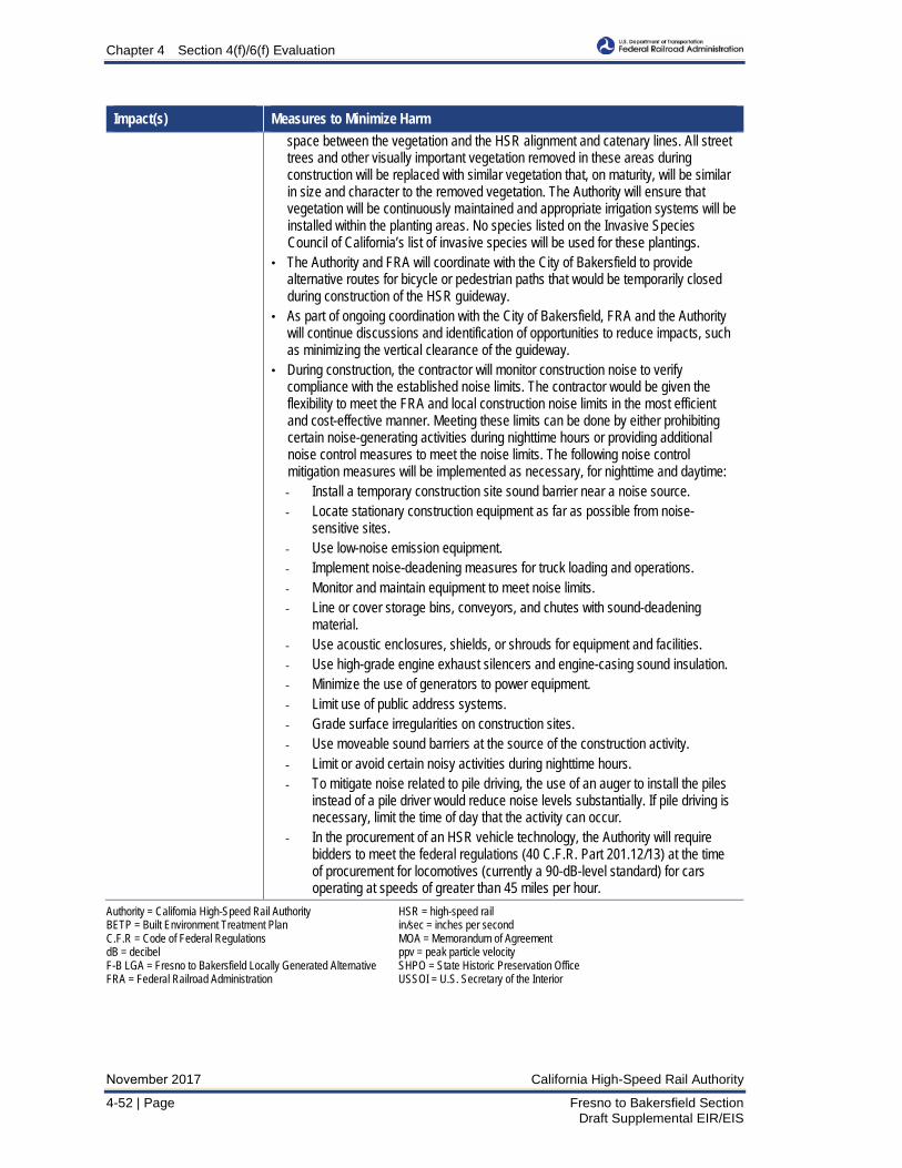
Chapter 4 Section 4(f)/6(f) Evaluation
November 2017 California High-Speed Rail Authority
4-52 | Page Fresno to Bakersfield Section Draft Supplemental EIR/EIS
Impact(s) Measures to Minimize Harm space between the vegetation and the HSR alignment and catenary lines. All street trees and other visually important vegetation removed in these areas during construction will be replaced with similar vegetation that, on maturity, will be similar in size and character to the removed vegetation. The Authority will ensure that vegetation will be continuously maintained and appropriate irrigation systems will be installed within the planting areas. No species listed on the Invasive Species Council of California’s list of invasive species will be used for these plantings.
• The Authority and FRA will coordinate with the City of Bakersfield to providealternative routes for bicycle or pedestrian paths that would be temporarily closedduring construction of the HSR guideway.
• As part of ongoing coordination with the City of Bakersfield, FRA and the Authoritywill continue discussions and identification of opportunities to reduce impacts, suchas minimizing the vertical clearance of the guideway.
• During construction, the contractor will monitor construction noise to verifycompliance with the established noise limits. The contractor would be given theflexibility to meet the FRA and local construction noise limits in the most efficientand cost-effective manner. Meeting these limits can be done by either prohibitingcertain noise-generating activities during nighttime hours or providing additionalnoise control measures to meet the noise limits. The following noise controlmitigation measures will be implemented as necessary, for nighttime and daytime:- Install a temporary construction site sound barrier near a noise source.- Locate stationary construction equipment as far as possible from noise-
sensitive sites. - Use low-noise emission equipment. - Implement noise-deadening measures for truck loading and operations. - Monitor and maintain equipment to meet noise limits. - Line or cover storage bins, conveyors, and chutes with sound-deadening
material. - Use acoustic enclosures, shields, or shrouds for equipment and facilities. - Use high-grade engine exhaust silencers and engine-casing sound insulation. - Minimize the use of generators to power equipment. - Limit use of public address systems. - Grade surface irregularities on construction sites. - Use moveable sound barriers at the source of the construction activity. - Limit or avoid certain noisy activities during nighttime hours. - To mitigate noise related to pile driving, the use of an auger to install the piles
instead of a pile driver would reduce noise levels substantially. If pile driving is necessary, limit the time of day that the activity can occur.
- In the procurement of an HSR vehicle technology, the Authority will require bidders to meet the federal regulations (40 C.F.R. Part 201.12/13) at the time of procurement for locomotives (currently a 90-dB-level standard) for cars operating at speeds of greater than 45 miles per hour.
Authority = California High-Speed Rail Authority HSR = high-speed rail BETP = Built Environment Treatment Plan in/sec = inches per second C.F.R = Code of Federal Regulations MOA = Memorandum of Agreement dB = decibel ppv = peak particle velocity F-B LGA = Fresno to Bakersfield Locally Generated Alternative SHPO = State Historic Preservation Office FRA = Federal Railroad Administration USSOI = U.S. Secretary of the Interior
Chapter 4 Section 4(f)/6(f) Evaluation
California High-Speed Rail Authority November 2017
Fresno to Bakersfield Section Page | 4-53 Draft Supplemental EIR/EIS
Proposed measures to minimize harm for all historic properties are listed together in Table 4-4; measures pertaining to each individual historic property are outlined in Section 3.17, Cultural Resources, of this Draft Supplemental EIR/EIS.
General measures that would minimize harm to all potentially affected properties as a result of noise or visual intrusion are listed in Section 3.4, Noise and Vibration, and Section 3.16, Aesthetics and Visual Resources, of this Draft Supplemental EIR/EIS.

Chapter 4 Section 4(f)/6(f) Evaluation
November 2017 California High-Speed Rail Authority
4-54 | Page Fresno to Bakersfield Section Draft Supplemental EIR/EIS
This page is left intentionally blank