Embed Size (px)
Citation preview
Scoping Report – July 2008 (5C1333/4/1)
29
4 Urban Design Issues & Goals
Urban design is a primary consideration for preparing a development strategy for State
Highway 1. It is crucial for the future vibrancy and vigour of the Kapiti Coast communities
that SH1 is appropriately integrated with the surrounding environment and adjacent land
uses. To achieve this, the need for a high capacity road through the district must be
balanced against the need to maintain and improve:
• Access to services and community facilities;
• Amenity of public spaces; and
• Community cohesion.
Central to achieving these objectives is the need to address the severance resulting from
transport infrastructure such as SH1 and the NIMT railway. By identifying the issues,
constraints and opportunities for realising good urban design in Paraparaumu, Waikanae
and Otaki early in the project, it will be possible to achieve the positive outcomes sought by
the community.
This chapter summarises urban design principles, previous urban design work
commissioned by KCDC and identifies the known issues, opportunities and constraints that
will guide the development of the SH1 strategy, particularly with respect to the three urban
areas.
4.1 Principles of Urban Design
The vibrancy of Kapiti Coast is a function of how land is used. The SH1 strategy will need
to highlight and take advantage of opportunities to encourage or facilitate the use of areas
alongside the corridor. An UK ‘Urban Design Compendium’4 describes developments that
epitomises good urban design and states that:
“for places to be well-used and well-loved, they must be safe, comfortable, varied and
attractive. They also need to be distinctive, and offer variety, choice and fun. Vibrant
places offer opportunities for meeting people, playing in the street and watching the world
go by.”
The New Zealand Government has been actively seeking to promote good urban design.
Two Government publications at the forefront such initiatives are:
• NZ Urban Design Protocol5, and
• National Guidelines for Crime Prevention through Environmental Design in New
Zealand (CPTED)6.
4 (P.14) English Partnerships and the Housing Corporation English Partnerships 2000
5 Ministry for the Environment, March 2005
6 Ministry for Justice, November 2005
Scoping Report – July 2008 (5C1333/4/1)
30
The Ministry of Transport, Land Transport NZ and Transit NZ are all signatories to the
Urban Design protocol. The Transit Board has also approved an Urban Design Policy for
the development and operation of the State highway Road network. The policy is
consistent with Transit’s commitment to the protocol and the broader concept of
sustainable transportation. Transit NZ has also published an Urban Design Professional
Services Guide (PSG/12) which explains when and how urban design assessments should
be incorporated within Transit projects.
4.1.1 NZ Urban Design Protocol
The ‘Seven C’s of good urban design as presented in the NZ Urban Design Protocol are:
• Context – urban design has a strong spatial dimension and optimises relationships
between buildings, spaces, places, activities, and networks. It also recognises that
towns and cities are part of a constantly evolving relationship between people, land,
culture and the wider environment.
• Character – quality urban design reflects and enhances the distinctive character and
culture of our urban environment and recognises that character is dynamic and
evolving, not static. Fosters strong urban identities.
• Choice – fosters diversity and offers people choice in the urban form of our towns and
cities, and choice in densities, building types, transport options and activities.
• Connections – good connections enhance choice, support social cohesion, make
places lively and safe, and facilitate contact among people. All networks connect and
support health towns, and where physical layouts and activity patterns are easily
understood, residents and visitors can navigate easily
• Creativity – adds richness and diversity and turns a functional place into a memorable
place.
• Custodianship – reduces environmental impacts through environmentally sustainable
and responsive design, it creates enjoyable safe public places and a quality
environment that is cared for and a sense of ownership and responsibility in all guests
and visitors.
• Collaboration – good communication and coordinated action from all decision-makers
and involving communities.
4.1.2 Guidelines for Crime Prevention through Environmental Design (COPTED)
COPTED, published by the Ministry for Justice is designed to improve personal security
through better urban design. It highlights that design for personal security is particularly
important in the development of public space and transport facilities. The importance is
largely due their use for much of the day. Key considerations for creating personal security
include:
• Surveillance – people are present and can see;
• Access Management – attract people to some places, restrict from others;
• Territorial Reinforcement – clear boundaries give ‘ownership’;
• Quality Environments – attract people and support surveillance.
Scoping Report – July 2008 (5C1333/4/1)
31
With regard to passenger transport facilities, there is a particular need to encourage activity
(i.e. promote surveillance), close to vulnerable locations. Management and maintenance of
passenger transport infrastructure and interchanges is also important. A combination of
maintenance and active surveillance will help to preserve amenity and reduce the threat of
crime.
4.2 Kapiti Coast Urban Design Studies / Local Outcome Statements
SH1 passes through the three main urban areas in the Kapiti Coast. The road and the
railway results in segregation of communities can present barriers to movement and can
limit the active use or development of land on either side of the corridor. Limiting the use of
land within urban areas can result in a reduction in ‘activity’ and vibrancy leading to
degradation in the quality of the public realm.
KCDC have commissioned several studies which aim to provide a framework for
developing the three main centres within the district. The previous studies have sought to
develop agreed community outcomes and strategies for achieving them. The Council has
also sought to develop town centre plans and engineering designs for road-rail alignments
and car park layouts.
Each of these studies, strategies or solutions has identified a range of existing issues and
opportunities, and in some case giving rise to additional issues and/or opportunities. The
following sections set out the urban design issues for Otaki, Waikanae and Paraparaumu
and identify the considerations for developing a SH1 strategy.
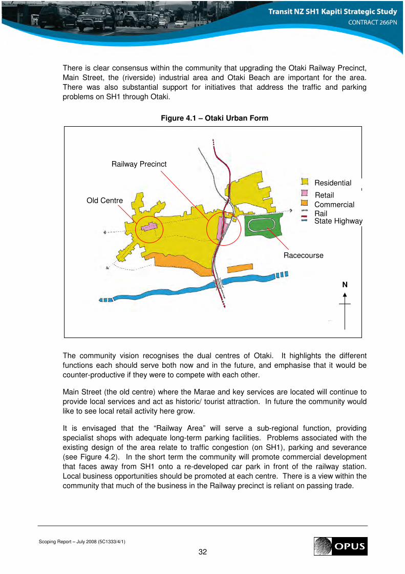
4.3 Otaki
In Otaki, much of the retail development is linear and follows the SH1 corridor so that large
numbers of commercial properties abut or are in close proximity to the state highway. An
older centre is located approximately 1km to the north-west of SH1 selling food and other
goods. The older centre is equidistant from SH1 and Otaki Beach. Commercial / light
industrial development (Winstone’s plant) is located on either side of SH1 along the
northern bank the Otaki River.
The majority of residential development is located to the west of SH1, but east of the old
centre. There is also a smaller residential area, disconnected from the main urban area;
east of SH1 and north of the racecourse refer to Figure 4.1.
4.3.1 Previous Studies
The Greater Otaki Project was instigated by KCDC and aimed to engage with the
community in order to develop a Vision for Otaki. Residents and business people from the
wider community participated in a series of workshops to explore various aspects of
development. The opinions expressed in the workshops were used to develop the vision
and detailed community outcomes, many of which are relevant to this project.
Scoping Report – July 2008 (5C1333/4/1)
32
There is clear consensus within the community that upgrading the Otaki Railway Precinct,
Main Street, the (riverside) industrial area and Otaki Beach are important for the area.
There was also substantial support for initiatives that address the traffic and parking
problems on SH1 through Otaki.
Figure 4.1 – Otaki Urban Form
The community vision recognises the dual centres of Otaki. It highlights the different
functions each should serve both now and in the future, and emphasise that it would be
counter-productive if they were to compete with each other.
Main Street (the old centre) where the Marae and key services are located will continue to
provide local services and act as historic/ tourist attraction. In future the community would
like to see local retail activity here grow.
It is envisaged that the “Railway Area” will serve a sub-regional function, providing
specialist shops with adequate long-term parking facilities. Problems associated with the
existing design of the area relate to traffic congestion (on SH1), parking and severance
(see Figure 4.2). In the short term the community will promote commercial development
that faces away from SH1 onto a re-developed car park in front of the railway station.
Local business opportunities should be promoted at each centre. There is a view within the
community that much of the business in the Railway precinct is reliant on passing trade.
Residential
Retail
Commercial Rail State Highway
N
Railway Precinct
Old Centre
Racecourse
Scoping Report – July 2008 (5C1333/4/1)
33
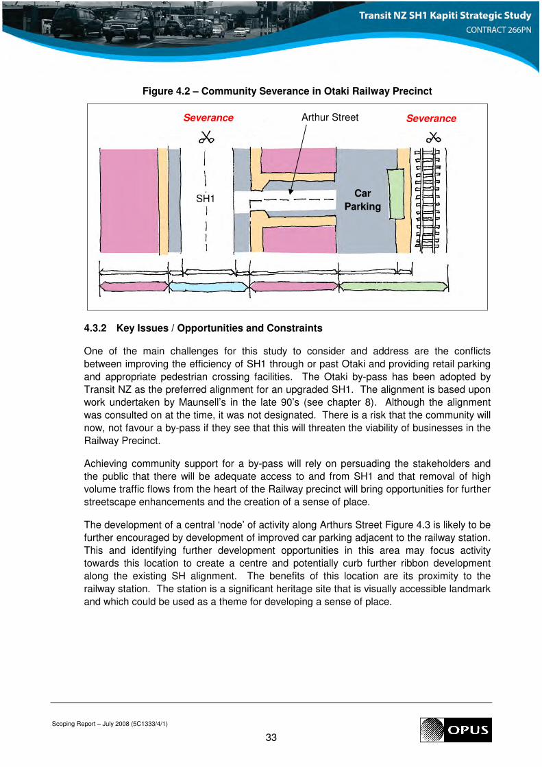
Figure 4.2 – Community Severance in Otaki Railway Precinct
4.3.2 Key Issues / Opportunities and Constraints
One of the main challenges for this study to consider and address are the conflicts
between improving the efficiency of SH1 through or past Otaki and providing retail parking
and appropriate pedestrian crossing facilities. The Otaki by-pass has been adopted by
Transit NZ as the preferred alignment for an upgraded SH1. The alignment is based upon
work undertaken by Maunsell’s in the late 90’s (see chapter 8). Although the alignment
was consulted on at the time, it was not designated. There is a risk that the community will
now, not favour a by-pass if they see that this will threaten the viability of businesses in the
Railway Precinct.
Achieving community support for a by-pass will rely on persuading the stakeholders and
the public that there will be adequate access to and from SH1 and that removal of high
volume traffic flows from the heart of the Railway precinct will bring opportunities for further
streetscape enhancements and the creation of a sense of place.
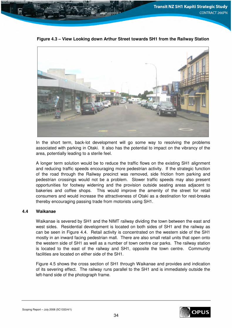
The development of a central ‘node’ of activity along Arthurs Street Figure 4.3 is likely to be
further encouraged by development of improved car parking adjacent to the railway station.
This and identifying further development opportunities in this area may focus activity
towards this location to create a centre and potentially curb further ribbon development
along the existing SH alignment. The benefits of this location are its proximity to the
railway station. The station is a significant heritage site that is visually accessible landmark
and which could be used as a theme for developing a sense of place.
SH1 Car
Parking
Arthur Street Severance Severance
Scoping Report – July 2008 (5C1333/4/1)
34
Figure 4.3 – View Looking down Arthur Street towards SH1 from the Railway Station
In the short term, back-lot development will go some way to resolving the problems
associated with parking in Otaki. It also has the potential to impact on the vibrancy of the
area, potentially leading to a sterile feel.
A longer term solution would be to reduce the traffic flows on the existing SH1 alignment
and reducing traffic speeds encouraging more pedestrian activity. If the strategic function
of the road through the Railway precinct was removed, side friction from parking and
pedestrian crossings would not be a problem. Slower traffic speeds may also present
opportunities for footway widening and the provision outside seating areas adjacent to
bakeries and coffee shops. This would improve the amenity of the street for retail
consumers and would increase the attractiveness of Otaki as a destination for rest-breaks
thereby encouraging passing trade from motorists using SH1.
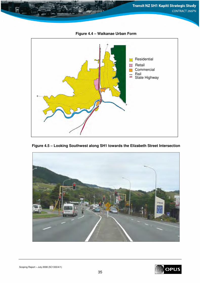
4.4 Waikanae
Waikanae is severed by SH1 and the NIMT railway dividing the town between the east and
west sides. Residential development is located on both sides of SH1 and the railway as
can be seen in Figure 4.4. Retail activity is concentrated on the western side of the SH1
mostly in an inward facing pedestrian mall. There are also small retail units that open onto
the western side of SH1 as well as a number of town centre car parks. The railway station
is located to the east of the railway and SH1, opposite the town centre. Community
facilities are located on either side of the SH1.
Figure 4.5 shows the cross section of SH1 through Waikanae and provides and indication
of its severing effect. The railway runs parallel to the SH1 and is immediately outside the
left-hand side of the photograph frame.
Scoping Report – July 2008 (5C1333/4/1)
35
Figure 4.4 – Waikanae Urban Form
Figure 4.5 – Looking Southwest along SH1 towards the Elizabeth Street Intersection
Residential
Retail Commercial Rail State Highway
Scoping Report – July 2008 (5C1333/4/1)
36
Elizabeth Street provides access from SH1 to the eastern side of Waikanae, Te Moana and
Ngaio Roads providing access to the west. Together these local roads act as a staggered
cross road for vehicle trips from one side of Waikanae to the other. There are also a
number of smaller intersections and accesses from the western side of SH1 to retail and
residential areas. The provision of these accesses and connections to local roads
perpetuates reliance on SH1 for access and movement within the town centre.
Light industrial development is located on the south-eastern edge of the urban area, south
of Elizabeth Street. Also to the south, but on the western side of the SH1 are a gas station
and south of the Waikanae River, a cement works.
4.4.1 Previous Studies
Work by Urbanismplus Ltd culminated in a report documenting the process and outcomes
of an “inquiry by design” workshop held in June 20077. The workshops aimed to identify
the community aspirations for Waikanae and to develop potential transportation options for
further development. The study identified the following issues to be addressed:
• severing effect of SH1 and the railway;
• the current poor level of service / amenity for pedestrians and cyclists using SH1;
• town centre connectivity and legibility for pedestrians and cyclists;
• poor access to the railways station from the town centre;
• lack of active edges within the town centre;
• dominance of car parking in the town centre core reducing vibrancy and activity; and
• homogenous development leading to a lack of vibrancy.
During the workshop stakeholders were guided through different options for developing the
town centre around an upgraded SH1. Different scenarios including trenching of SH1 so
that local connections pass over from east to west and local road underpasses were
considered. The option preferred by those that attended the workshop included
• the closure of the connection between Elizabeth Street and SH1;
• an underpass from Te Moana Road to a new connection with Elizabeth Street close to
its intersection with Seddon Street;
• a new vehicular underpass from Ngaio Road to Utauta Street
• service lane along the active retail frontages on the western side of SH1;
• a pedestrian bridge across SH1 from the mall to the bottom of Elizabeth Street; and
• a large new car park serving the railway station.
4.4.2 Key Issues / Opportunities and Constraints
Previous town centre studies have identified severance as one of the most significant
issues created by the existing SH1 / Rail corridor. As traffic on SH1 has increased, the
Waikanae town centre retail node has gradually begun to turn away from the road inwards
7 Waikanae Town Centre: Workshop Final Outcomes Document, Urbanismplus Ltd, Sept 2007
Scoping Report – July 2008 (5C1333/4/1)
37
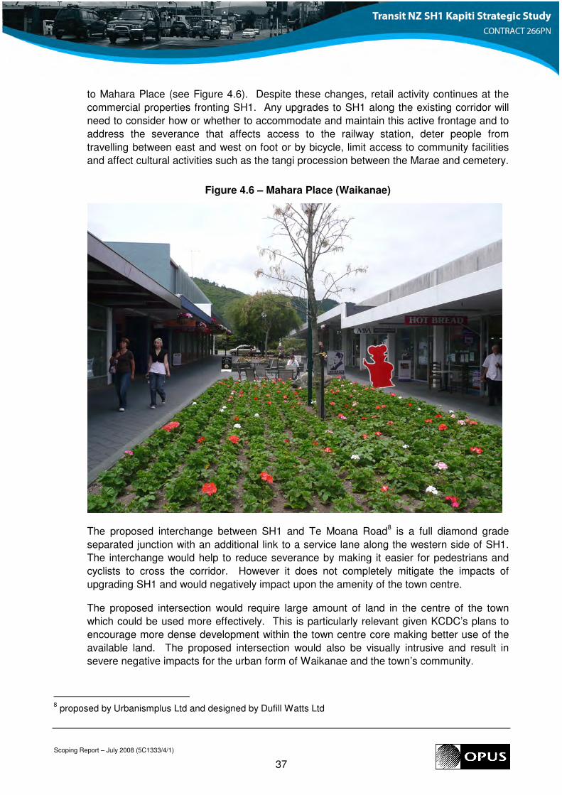
to Mahara Place (see Figure 4.6). Despite these changes, retail activity continues at the
commercial properties fronting SH1. Any upgrades to SH1 along the existing corridor will
need to consider how or whether to accommodate and maintain this active frontage and to
address the severance that affects access to the railway station, deter people from
travelling between east and west on foot or by bicycle, limit access to community facilities
and affect cultural activities such as the tangi procession between the Marae and cemetery.
Figure 4.6 – Mahara Place (Waikanae)
The proposed interchange between SH1 and Te Moana Road8 is a full diamond grade
separated junction with an additional link to a service lane along the western side of SH1.
The interchange would help to reduce severance by making it easier for pedestrians and
cyclists to cross the corridor. However it does not completely mitigate the impacts of
upgrading SH1 and would negatively impact upon the amenity of the town centre.
The proposed intersection would require large amount of land in the centre of the town
which could be used more effectively. This is particularly relevant given KCDC’s plans to
encourage more dense development within the town centre core making better use of the
available land. The proposed intersection would also be visually intrusive and result in
severe negative impacts for the urban form of Waikanae and the town’s community.
8 proposed by Urbanismplus Ltd and designed by Dufill Watts Ltd
Scoping Report – July 2008 (5C1333/4/1)
38
Future development in Waikanae is planned on the northern side of the town as an urban
extension. There already a number of residential dwellings immediately adjacent to SH1.
Although the majority of the proposed urban extension is located some way from the road,
the development would increase the number of people potentially affected by noise,
vibration and airborne pollutants. Options to relocate Waikanae Railway station to the
northern fringe of the town were considered and discounted during the 2007 workshops.
Given the desire to retain a town centre passenger transport interchange it will be important
to develop the character of the railway station making it a recognisable and admired
feature: giving it a ‘presence’ in the town.
4.5 Paraparaumu
Paraparaumu is the largest settlement in Kapiti Coast District. The town serves a sub-
regional function, offering larger retail facilities and providing the administrative function for
the District. A significant proportion of the district’s employment opportunities are located
in the town.
The SH1 / rail corridor passes immediately through the centre of the Paraparaumu urban
area again resulting in community severance. Much of property along SH1 faces away
from the road. Often this has taken the form of poorly maintained frontages, or visual
barriers such as extensive areas of planting. This affects the amenity of the route making it
unpleasant to walk or cycle along and discouraging roadside activity. The town centre has
however retained some frontage around the Kapiti lights, and north to the urban fringe just
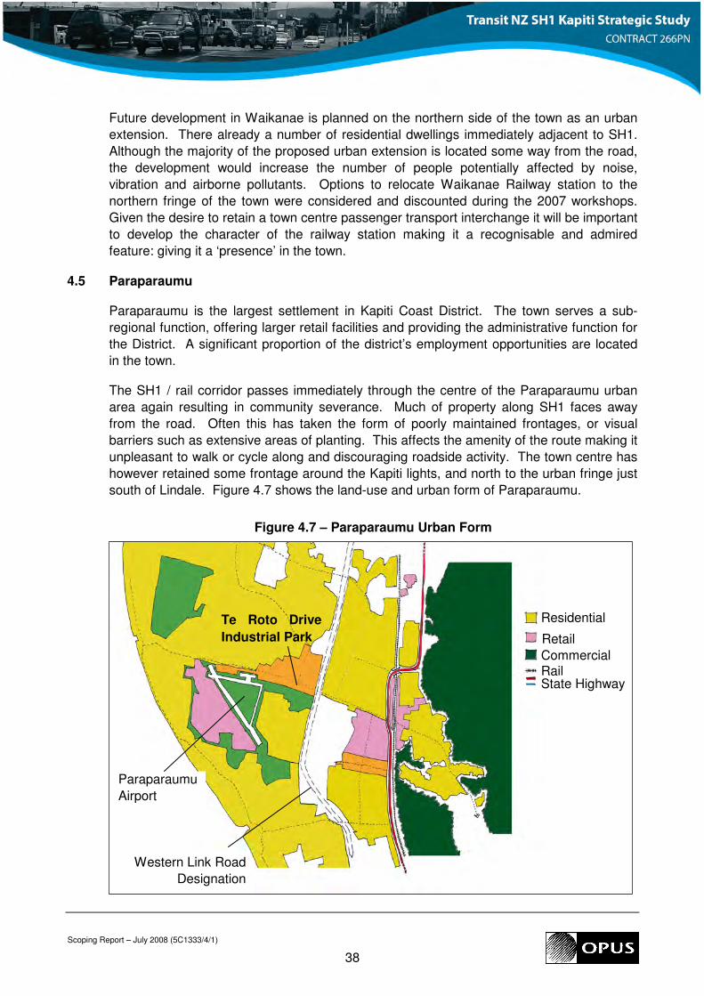
south of Lindale. Figure 4.7 shows the land-use and urban form of Paraparaumu.
Figure 4.7 – Paraparaumu Urban Form
Paraparaumu
Airport
Western Link Road
Designation
Residential
Retail
Commercial Rail State Highway
Te Roto Drive
Industrial Park
Scoping Report – July 2008 (5C1333/4/1)
39
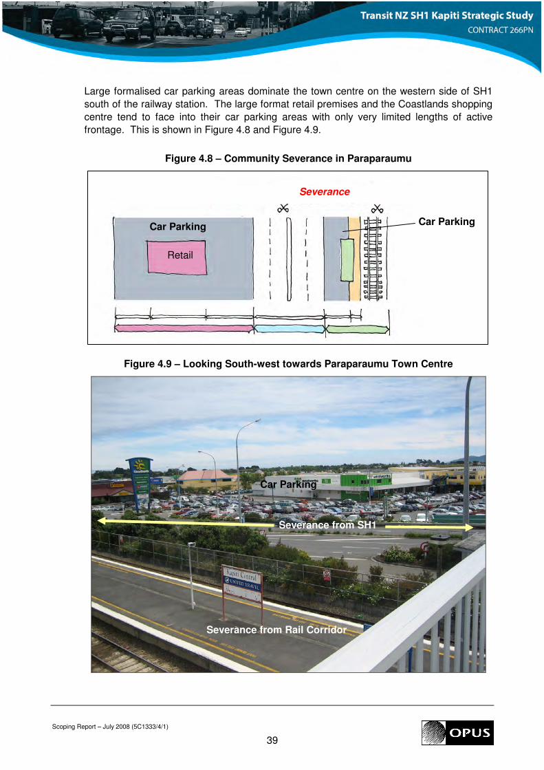
Large formalised car parking areas dominate the town centre on the western side of SH1
south of the railway station. The large format retail premises and the Coastlands shopping
centre tend to face into their car parking areas with only very limited lengths of active
frontage. This is shown in Figure 4.8 and Figure 4.9.
Figure 4.8 – Community Severance in Paraparaumu
Figure 4.9 – Looking South-west towards Paraparaumu Town Centre
Car Parking Car Parking
Severance
Retail
Severance from Rail Corridor
Severance from SH1
Car Parking
Scoping Report – July 2008 (5C1333/4/1)
40
The SH1 / Rail corridor is at its widest in Paraparaumu / Raumati resulting in a high degree
of severance despite the pedestrian over bridge across the railway. The road and railway
also present a physical and visual barrier which affects the way in which the community
accesses services and facilities in the town. Significantly in the northern portion of the
urban area where the carriageway is only one lane in each direction, active frontage and
residential frontages have been retained. There is also much greater separation between
road and rail at this point.
Like Waikanae, Paraparaumu railway station is severed from much of the urban area (both
employment and residential) to the west. Pedestrians and cyclists access the station via a
signalised crossing. While such a crossing does facilitate the desired east-west movement
across the corridor, it does not address amenity issues. Increasing the ease in which the
community may access the railway station should help to encourage more inter-urban
travel by rail rather than by car particularly if the railway station becomes better integrated
within the town centre hub.
4.5.1 Previous Studies
Paraparaumu residents have identified the SH corridor as the cause of significant
severance between the eastern and western halves of the community. This is exacerbated
by the NIMT Railway. KCDC’s plans for developing the town centre9 would see medium
density development with retail units at the ground floor level for most buildings and
residential development above. The Council also plans to improve the street scene and
identity of separate commercial and civic areas. This will involve landscaping to create new
aquatic and recreation centres on Council owned land.
4.5.2 Key Issues / Opportunities and Constraints
Paraparaumu town centre is the primary retail, commercial and administrative centre for
Kapiti Coast. As such it is used by residents from throughout the district and attracts
visitors from outside the area. It is therefore important that the town centre functions well
and presents a positive image to the community and to visitors.
The severance caused by SH1 and the railway is the primary issue that should be
addressed to encourage active travel within the town. Addressing severance and
increasing access to the railway station will also improve the attractiveness of inter-urban
travel by rail.
A key action to increase human activity and hence improve the amenity within the town
centre will be to address the large areas of inefficient land development currently used for
car parking during the day. There is also an opportunity to make use of existing active
edges at the Kapiti Lights development, building upon the activity surrounding commercial,
retail and entertainment activity. This development is on the pedestrian desire line from the
railway station to Paraparaumu retail quarter and could become a relatively attractive
gateway to the town. Consideration could be given to providing a high quality public space
/ plaza opportunity in this location.
9 Paraparaumu Town Centre Local Outcomes Statement, Kapiti Coast District Council
Scoping Report – July 2008 (5C1333/4/1)
41
4.6 Development Frameworks
4.6.1 Connectivity and modal choice
Connectivity and modal choice are strongly linked. It is not purely the presence of a link
that will determine its success, but also its attractiveness. Attractiveness is linked to
amenity and considerations such as activity, vibrancy, safety and convenience (direct and
legible routes). This is particularly true for non-motorised activities such as walking, cycling
and also passenger transport (bus).
Community workshops organised by KCDC from 2003 onwards highlighted community
concerns about physical severance, such as the barrier presented by SH1 and its impact
on the attractiveness (convenience, perceived safety etc) of active travel in urban areas.
Previous studies investigating transportation solutions for the SH1 alignment have in many
cases identified possible east-west links across SH1 for pedestrians, cyclists, and local
traffic.
This study will look at opportunities for increasing the permeability of the SH1 / rail corridor
and increasing the attractiveness of pedestrian and cyclist routes, alongside and across the
SH1 corridor. In some cases this may be achieved by freeing up land that would otherwise
be used for car parking, for development as passenger transport interchanges or for
amenity improvements that will contribute towards increased pedestrian and cycle use.
4.6.2 Personal Safety
Any development framework for the three urban areas will need to address the issue of
personal safety, and the implications that can arise as a result of design, location of
development and activity. A development framework for the State Highway will incorporate
the concepts presented in “Crime Prevention through Environmental Design” (CPTED).
A number of development plans and strategies have already been identified for the urban
areas, and include features that would benefit from CPTED type assessments