Embed Size (px)
Citation preview
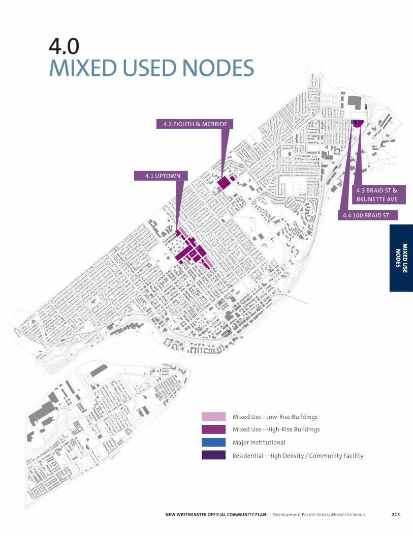
NEW WESTMINSTER OFFICIAL COMMUNITY PLAN — Development Permit Areas: Mixed Use Nodes 213
MIX
ED U
SE N
OD
ES
4.0 MIXED USED NODES
Mixed Use - Low-Rise Buildings
Mixed Use - High-Rise Buildings
Major Institutional
Residential - High Density / Community Facility
MIX
ED U
SE N
OD
ES
4.1 UPTOWN
4.2 EIGHTH & MCBRIDE
4.3 BRAID ST &
BRUNETTE AVE
4.4 100 BRAID ST
NEW WESTMINSTER OFFICIAL COMMUNITY PLAN — Development Permit Areas: Mixed Use Nodes214
MIX
ED U
SE
NO
DES
4.0 MIXED USED NODESINTRODUCTION
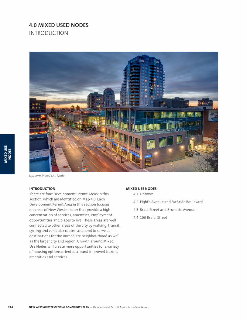
Uptown Mixed Use Node
INTRODUCTION
There are four Development Permit Areas in this
section, which are identified on Map 4.0. Each
Development Permit Area in this section focuses
on areas of New Westminster that provide a high
concentration of services, amenities, employment
opportunities and places to live. These areas are well
connected to other areas of the city by walking, transit,
cycling and vehicular routes, and tend to serve as
destinations for the immediate neighbourhood as well
as the larger city and region. Growth around Mixed
Use Nodes will create more opportunities for a variety
of housing options oriented around improved transit,
amenities and services.
MIXED USE NODES
4.1 Uptown
4.2 Eighth Avenue and McBride Boulevard
4.3 Braid Street and Brunette Avenue
4.4 100 Braid Street
NEW WESTMINSTER OFFICIAL COMMUNITY PLAN — Development Permit Areas: Mixed Use Nodes 215
MIX
ED U
SE N
OD
ES
4.0 MIXED USED NODESINTRODUCTION
GENERAL PRINCIPLES
Mixed Use Nodes encompass a variety of characteristics
that add to the vibrancy of a neighbourhood. The
following list includes some general building
parameters for livable, high-quality and sustainable
developments in Mixed Use Nodes.
1. CREATE NEIGHBOURHOOD CONNECTIONS
Creating a well-connected neighbourhood enhances
quality of life by promoting walkability, increasing
access to amenities and prioritizing pedestrian
and bike connections. Considerations for urban
mobility and connectivity need to be considered as a
complementary set – walkability, cycling, public transit
and vehicular and servicing/loading movement are
all important in planning a cohesive, functional and
livable community. Private developments can enhance
community connectivity by ensuring a fine-grained
pedestrian experience and thoughtful design of
attractive buildings and landscape interfaces along
street frontages, side streets, laneways and greenways.
2. ESTABLISH WELL-DEFINED STREETS
Street definition creates the feeling of an outdoor
room and is an important element in creating an urban
environment that is comfortable for pedestrians.
Buildings should be designed to frame streets and
open spaces at an appropriate scale. Creating an
appropriate setback for residential units at grade that
provides some privacy, but maintains the street edge
is important, along with stepping taller masses back to
create a consistent street wall.
3. DESIGN APPROPRIATELY SCALED BUILDINGS
Designing buildings with appropriate height and
massing will ensure that buildings fit with future
surrounding land uses, provide appropriate transitions
to adjacent developments, and create a livable
environment for neighbourhood residents. Massing
strategies can be employed to lessen the visual impact
of larger buildings, respond to topography and avoid
overshadowing of public and private outdoor spaces.
Buildings should be designed with context in mind
and create sensitive transitions to neighbouring
developments, whether it be commercial spaces,
public spaces, single detached dwelling or multi-unit
residential buildings.
4. ACTIVATE BUILDING FRONTAGES
Creating an active frontage at grade enhances public
safety and creates a lively streetscape. Buildings should
encourage a variety of scales of commercial spaces
along the street edge to increase activity along the
street edge. Buildings should have two level, ground
oriented, family friendly residential units with primary
entries along secondary streets and lanes.
5. INTEGRATE SUSTAINABLE STRATEGIES
New development should aim to support a broad range
of sustainability goals related to energy, water, waste,
materials and ecology. Landscaping that features
native plants, bioswales, greenroofs, pocket parks and
private outdoor spaces can all be employed to enhance
biodiversity as well as mitigate stormwater runoff.
Designing buildings with passive solar strategies
(orientation, shading, appropriate glazing and
insulation types) and efficient mechanical systems
are all ways to reduce energy demand. When possible,
a green buildings rating system (LEED, PassiveHouse,
etc) should be used to guide sustainable building
development.
6. ENHANCE PUBLIC REALM
A successful neighbourhood is built around a strong
public realm, providing places to walk, sit and
interact. Private development should enhance the
public realm of the neighbourhood to create a vibrant
and comfortable space for residents and visitors.
Street trees, landscaping, street furniture, weather
protection, lighting features and public art are all
important public realm components that can be
integrated into new development.
7. PROMOTE SAFETY + SECURITY
A well-designed building can create a sense of safety
and comfort for both building users and the public.
Through following the principles of Crime Prevention
Through Environmental Design (CPTED), buildings
can employ passive strategies that encourage casual
surveillance of public spaces, clearly delineate public
and private spaces, and ensure accessible and well
defined pedestrian and vehicular entrances.
NEW WESTMINSTER OFFICIAL COMMUNITY PLAN — Development Permit Areas: Mixed Use Nodes216
MIX
ED U
SE
NO
DES
CHAPTER 4: MIXED USE
4.0 MIXED USED NODESINTRODUCTION
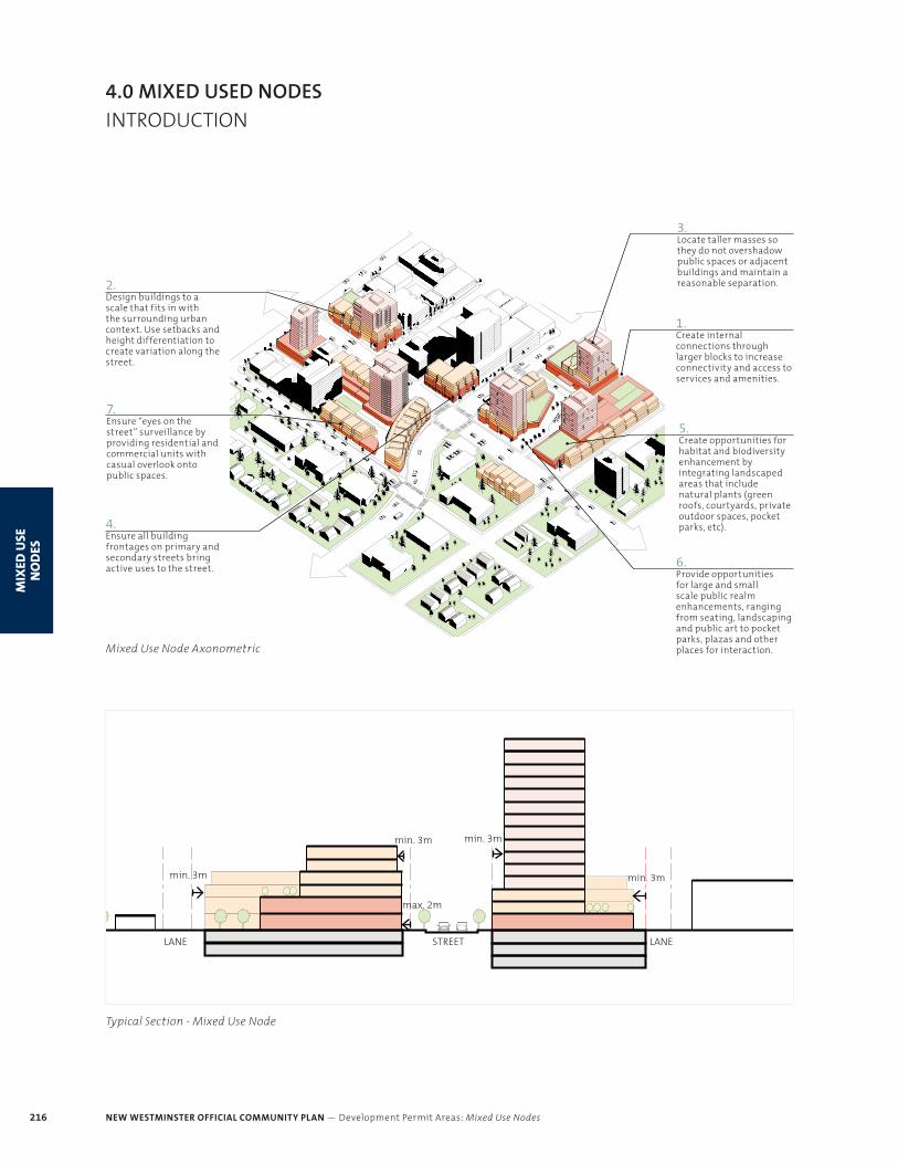
Mixed Use Node Axonometric
1.Create internal connections through larger blocks to increase connectivity and access to services and amenities.
5.Create opportunities for habitat and biodiversity enhancement by integrating landscaped areas that include natural plants (green roofs, courtyards, private outdoor spaces, pocket parks, etc).
6.Provide opportunities for large and small scale public realm enhancements, ranging from seating, landscaping and public art to pocket parks, plazas and other places for interaction.
2.Design buildings to a scale that fits in with the surrounding urban context. Use setbacks and height differentiation to create variation along the street.
3.Locate taller masses so they do not overshadow public spaces or adjacent buildings and maintain a reasonable separation.
4.Ensure all building frontages on primary and secondary streets bring active uses to the street.
7.Ensure “eyes on the street” surveillance by providing residential and commercial units with casual overlook onto public spaces.
STREETLANE LANE
min. 3mmin. 3m
min. 3m
max. 2m
min. 3m
Typical Section - Mixed Use Node
NEW WESTMINSTER OFFICIAL COMMUNITY PLAN — Development Permit Areas: Mixed Use Nodes 287
MIX
ED U
SE N
OD
ES
Delta
Burnaby
Surrey
Coquitlam
Richmond
Delta
Burnaby
Surrey
Coquitlam
Richmond
Annacis Channel
North Fraser RiverSapperton Channel
Fraser River
South Fraser River
4.1
4.2
4.3 4.4
Sixt
h S
tSi
xth
St
Twel
fth
St
Royal Ave
Eighth Ave Eighth Ave
Ewen Ave
E Colu
mbia
St
E Eighth Ave
Quayside Dr
Tenth Ave
Columbia St
Sixth Ave Sixth Ave
Ewen AveEwen Ave
Hol
ly A
ve
Brunette Ave
Jen
sen
St
Cumberland St
Fou
rth
St
Brunette Ave
Front StFront St
Ewen Ave
McB
rid
e B
lvd
McB
rid
e B
lvd
E Sixth Ave
Quayside Dr
Edworthy Way
Twen
tie
th S
t
Eigh
th S
t
Ten
th S
t
Richm
ond St
Pattullo Brid
ge
Columbia St
Stewardson Way
Boyd St
Der
wen
t Way
Boyd St
E Columbia St
Braid St
Fourth Ave
Sixt
h S
tSi
xth
St
Twel
fth
St
Royal Ave
Eighth Ave Eighth Ave
Ewen Ave
E Colu
mbia
St
E Eighth Ave
Quayside Dr
Tenth Ave
Columbia St
Sixth Ave Sixth Ave
Ewen AveEwen Ave
Hol
ly A
ve
Brunette Ave
Jen
sen
St
Cumberland St
Fou
rth
St
Brunette Ave
Front StFront St
Ewen Ave
McB
rid
e B
lvd
McB
rid
e B
lvd
E Sixth Ave
Quayside Dr
Edworthy Way
Twen
tie
th S
t
Eigh
th S
t
Ten
th S
t
Richm
ond St
Pattullo Brid
ge
Columbia St
Stewardson Way
Stewardson Way
Stewardson Way
Boyd St
Der
wen
t Way
Boyd St
E Columbia St
Braid St
Fourth Ave
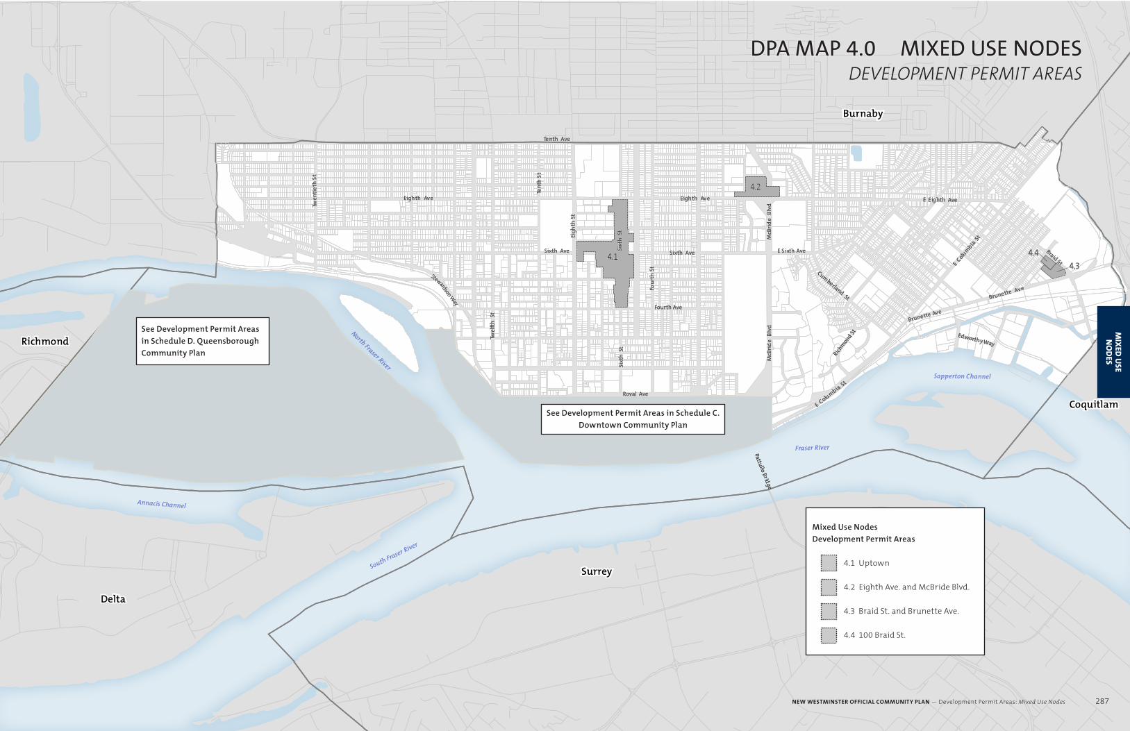
DPA MAP 4.0 MIXED USE NODESDEVELOPMENT PERMIT AREAS
See Development Permit Areas
in Schedule D. Queensborough
Community Plan
See Development Permit Areas in Schedule C.
Downtown Community Plan
Mixed Use Nodes
Development Permit Areas
4.1 Uptown
4.2 Eighth Ave. and McBride Blvd.
4.3 Braid St. and Brunette Ave.
4.4 100 Braid St.
NEW WESTMINSTER OFFICIAL COMMUNITY PLAN — Development Permit Areas: Mixed Use Nodes 287
MIX
ED U
SE N
OD
ES