Embed Size (px)
Citation preview
-::i:......,~"f ""P-/v"'L..J(-----:;:> ,ft~~~,<.-K.tr~< ... <"~~t\\...
w ~ -
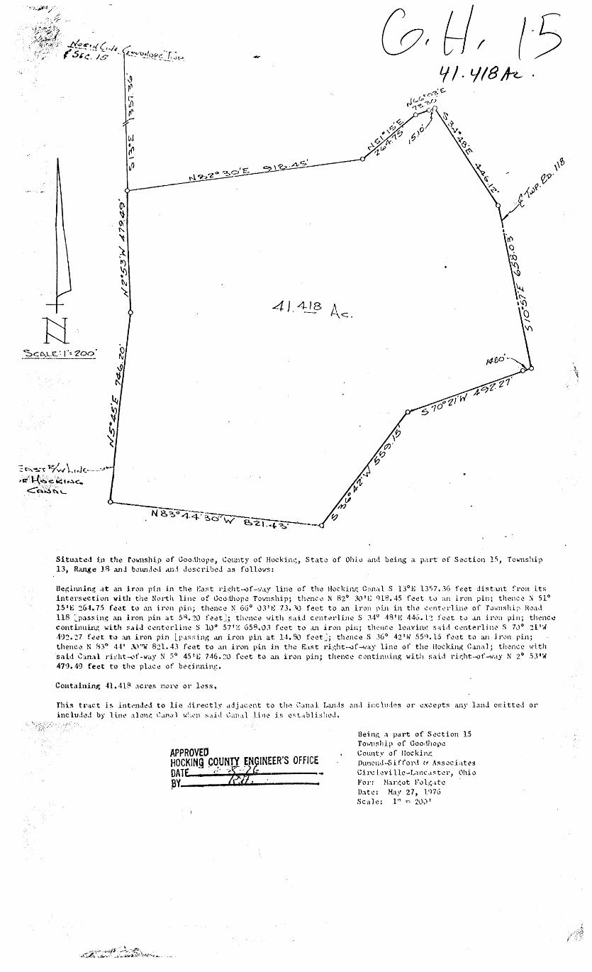
41 418 . -
Situat\!J in the fo\.11ship of Goo,thope, Cotmty of Hockirn.~, Stato of Ohio and being a. p,1rt of Section lS, Township 13, Range 18 anJ botmdctl aid dcscribcJ as follows:
BeAi1mlng at an iron pin in the Ea~t ri!!,ht--0f-11'a~· line of the Hocking C;rnal S 13°1'; 1357, JG feet dista.nt from its intcrsecthm vith the North line of Goo,:U1opc T01msh.ip; thencl~ N 82° 30 1 E 0l8.45 foet to an iron pin; thence~ 51° 15 '~ '.:!6-t- 75 foct to an ir<.m pin; thence N 66° 03 1 1-; 73 •. "-0 feet to an iron pin in the cent~~rl.inc of ruwnship Hoad 118 ~pas.sing an iron pin at 5R. ~O feet_]; tl11.•11ce 1dth sa.Li crnterlinc S 34° 48 1 !~ '14o. U feet t0 <tn i i·~)ll pin; thence continuing with !'aiJ centerline S 10° 57 1 1~ 658,03 feet to an in)n pin; thence lcavin.t~ said CL'nterlin.:- S 7·J 0 ~l'I.' ,19:?, 27 f ~ct to ~l iron pin Lp.1ssing an iron µin at H. 90 feet~; thence S 36° 42 1 \v' S59. 15 fl!et to an j rvn pin; thence N 8:3° 4-t' J\.)''W 8:!1. 4J feet to an ir1.m pin in the East ri,~ht-vf-way line of the Hocklng Ca.ni\1; thence with said C:m,-.1 ri.~:ht'""'1f-way N 5° 45 1 ~ 7·16. :o. feet to an iron pin; the-nee c._1ntimLing with sai,i riE;ht--of-w,ty N 2° .53'W 47~). 49 feet to the pla.Cl! of bl"d1ming.
Containing 41. 418 acres mo1·e or less.
Thi!\ tr<iCt i~ intt•nJl!,l to lie directl~· adjJ.ccnt to the Gan<:d. l,anJ.s <tll•l includes or excepts any LrnJ omi.ttc.I or inclu,!l!J by li.1H• alm1l! 1~..u1ii1 wL~'ll sai,l Ga1ul Linc is cst,tblis!1cd.
APPROVED HOCKINQ CO,UNTY ~N INEER'S OFFICE DAT ,., .. , .. "'
~Y---J.Ww...----
Being a part of Section 15 To1,ri1~hlp of Goo,tJ1opc
Count.v of Hockin~ Dw~c-nd-Sifford u AssocLltt>s Ci1'\; l·~vi llc-Lancd:::-tcr, Ohio 1''or: Har1~ot Fo 1-~·L tc Date: Hay 27, lq7G Scale: 1 11 = 2lh.) 1
/, 11 J ;~---~Y---------~
~<- ~~ I ( _ __;;> FORM 602-0HIO WARRANTY DEED ~· .. TUTBl.ANX RCQll!nCRCO u s PAT Ol'"FIClt
TI.JTTLC l.AW l"lllllllNT, PUBLISHERS, lllUT\.ANO. ll'f 08.,.01 . ·- " '-I~ . ., i.. _, f:>A-c. • t~
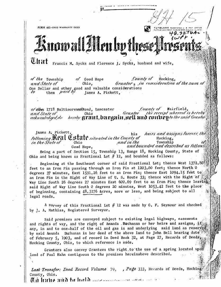
Jnow itU~tuh~ f~t~tJ rt$tf~Ji;t~,., W.lt at Francis M, Sycks and Florence J, Sycks, husband and wife, . J~;i?¥'~'l'.:h:
o/' the Township o/ Good Hope . ,('oun(y o/ Hocking, and Stale o/' · · Ohio, Ora11tor s I in r·r11tstden.tlt'r11t o/' the su11t. ol
One Dollar and ot~er good and valuable considerations lo them /.H1trl ~Y James A. Pickett, ·
::~:~:;~ ol~ 1718 Baltimore:xu.itRoad, I:.ancaster ,('rnattr o/' Bairfield, /~!·~ a1tr/Slate rJ/~ Ohio . OnuitnJ . ll1i1 rn·dpl wlten1r1/'1;~· lu·rebrJ'.-~~1 rtf"J(lumlf'f~fJf't(rlr1 ltN.,1V grnnt,h:irguitt ,s.ell Htt~ ntnh~t?lo 1/11' srtlrl On111it1':~~
.,:'.:11i1 '~(: ;'
James· A'~ Pickett' his luirs r11td assig11s l'orevn; tit /ollowillfl ]{ra l <£~tntt1 situated tit the Co1111/y ol' Hocking, iii the Stale o/ Ohio flntl tit the Township . o.
Good Hope, ' a;ul bo11r1r/N/ r111rl tlescnl1nl as /bl.low(~. Being a part of Section 15, Township 13, Hange 18, Hocking County, State of
Ohio and being known as Fractional Lot # 12, and bounded as follows: ·: .. }~
Beginning at the Southeast corner of said Fractional Lot; thence West 1372. 8d'a: feet to an Iron Pin passing through an Iro1~ Pin at 1203.00 feet; thence No~h ·o · .. ;';I~:!. degrees .rJ minutes, East 1591~26 feet to an Iron Pin; thence East 1094.15 fiet tQ:.~::,;i:~J;<F · 1 ~ an Ir~n Pin in the Right of Wa~ Line of U. s. Route 33; thence wit~ the Right'.~6f-;l~-~t-: !
1'
Way Line South 26 degrees 27 minutes East 6oO. 69 feet to an Iron Pin; thence leaVi'.n~. said J9.ght of Way Line South O degrees 20 minutes, West 105.3.42 feet. to the plac6'' >·':~ ~'{'. .. of beginning, containing 48.3276 acres, more.or less, and being subj~ct to all ·
,1
legal roads. ·
A survey of this Fractional Lot # 12 was made by G. F. Seymour and checked~· . by J. A. Mathias, Registered Surveyor.
Said premises are conv~yed subject to existing 1~gal highways, easements ... and rights of way, a.nd the righ~ of Amanda . Buchanan or her heirs and assigns, .,,i.:fi;~:,-. any, ~n and to· one-half o: the oil and gas in and unde~lying said land. ~s rese~}:;~ii·'
. by said Amanda Btchanan in her deed of the above land to John Bell bearing date: '"'f'·~\f of ·F.ebruary 5, 1903, and of record in Deed ·Book 32, at Page 27, Records of Deedfliu: Hocking County, Ohio, to. which reference is made. -
Grant ors also convey Grantees the right .. to ·the use of a spring land of Paul Hahn contiguous to the premises hereinabove described. ·,
uut ·Transfer: Deed Record Volume 79, , PaJe 333, Records of Deeds, Cotmty, Ohio. Olit fr Uh~ }ti't ~ tat· It •t I ~ .... :../ ~~ ~..... .... .. . .. ~'- ... 1uL- .... · ·~
·l»rt;;dP ,. 2-o th- ..
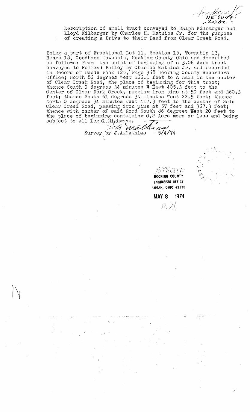
Description of small tre.ct conveye.d to Halph Ki1bargor and Lloyd Kilbarger by Charles II. Mathias Jr. for the purpose of creating a Drive to their Land from Clear Creek Road.
Being a part of Fractional Lot 11, Section 15, Township 13, Rance 18, Goodhope Township, Hocking County Ohio and described as follows: From the point of begin1~ing of a 3.06 Acre tract conveyed to Rolland Bailey by Charles Iv~athias Jr. aLd recorded in Record of Deeds }3ook 125, ·Page 968 Hocking County Recorders Office; North 86 degrGes West 166.1 feet to a nail in the center of Clear Creek Road, the plc:.ce of beginning for this tract; tlrnnce South 0 degrees 34 minutes W East 405. 3 feet to the Cer..ter of Clear :b1ork Cree~:\:, passing iron pins e:~t 50 feet ar:.d 360.3 feet; thence Sou.th 61 degrees 34 minutes West 22.5 feet; thence North 0 degrees 34 minutes \"/est 417. 3 feet to the center of Said Cle~r Creed Road, psssin~ iron pins at 57 feet and 367.3 feet; thence with center of said Roc_i,d South 86 degrees f{ast 20 feet to the place of beginning containing 0.2 Acre more or less and being subject to all Legsl :~~ .. -Il~h~m;rs. ·- -;- /!.~
.- .>.;.--·t::-1 m~~-6ru./l~ Survey by· J.A.Muthias · 5/4/74
/)i'l/1 1([
1{ ()
HOCKING COUMTY ENGtNHRS OHICE
lOGAK, OHIO 4313B
MAY 8 1974
f(,j:/
.... . , .
i"•. ,,
"·' . r· ¢\ ' <-',,.
·' f •
S "-:Yr 0 e vf /)-eccl /f&J'i~
d<-vi .')/
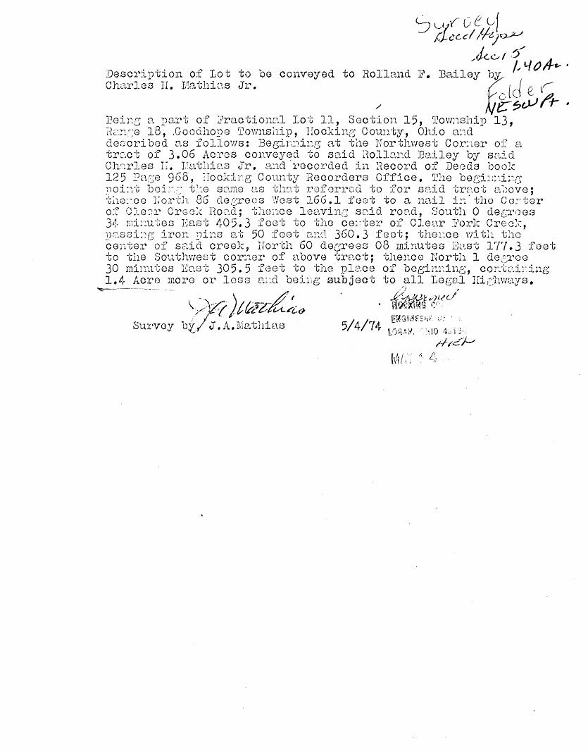
:Oescri1)tion of Lot to be conveyed to Rolland F. J3ail:y ~bY, Pl ()/1-c- ' Charles II. Mo.thins Jr. 1 f ir
/ . ~~c.Sf'r :Beine; o. part of J?ractionc:.l Lot 11, Section 15, ~Cownship 13, 1-(c:~:::J..~_;e 18, .Goodh0}/8 Townshi11, Hocking County, Ohio and deccri bed as follows: Bee;inrd1:g at the Northvrest Cor:rnr of a tract of 3.06 Acres co1w0yed to said Rollnnd Bailey by snid Ch'.::.rles IT. rathie.s Jr. and 'recorded in iiecord of Deods book 12 5 Pace 968, IIockir.g County Hecorders Office. The bec;L;:~_L:g ~)Qi:1t boi_~~-t· t~.:e sci,me as thc,,t rof errocl to for said tract a~)ove; tho:·.co l~orth 86 decrees West 166.1 f~cwt to a nail ir:.· tho Co:-ter o~~= Cle::.n~ Crc:::o: .. : Hoc1.d; thonce lo::.:winG scdd roi:-1,d, South 0 dec::;roes 34 rni;:utes I~ast 405. 3 feet to the ce:'ter of CJ.ear :G1ork Croo:c, 1n.:.ssi:;13 iror .. ~)ins at 50 feet ci..::d 360.3 feet; thei·~ce v:itli the center of s2:.icl creek, Irorth 60 dec;rees 08 minutes E\..1,st 17'/. 3 feet to the Southwest cor:1or of above tract; ther:.co North 1 det:,Tee 30 minutes J!~o.st 305. 5 feet to the place of bee;im1inc;, cor:ccd:~ing 1.4 Aero more or loss a~::.c1 beiLg subject to· all Legal IIichways. ~--- -~ ,.") ' - ) L, ... f-it~tv)Ltl.l
\ - '\-·/ 11;."f-r V'/ H~~~~ r. 1 ·, /·""'£: { , v f.t'"C ~ t;..{../i&
Survey b~ / J. A. I\~P .. thias 5/ 4/74 [H~C~i~Ff.i~;: \.'.~ «... \\,(if~.~~ I > 10 1L 1 j j)
;;//,~-;~
hit;.,·: : t;;
I l I
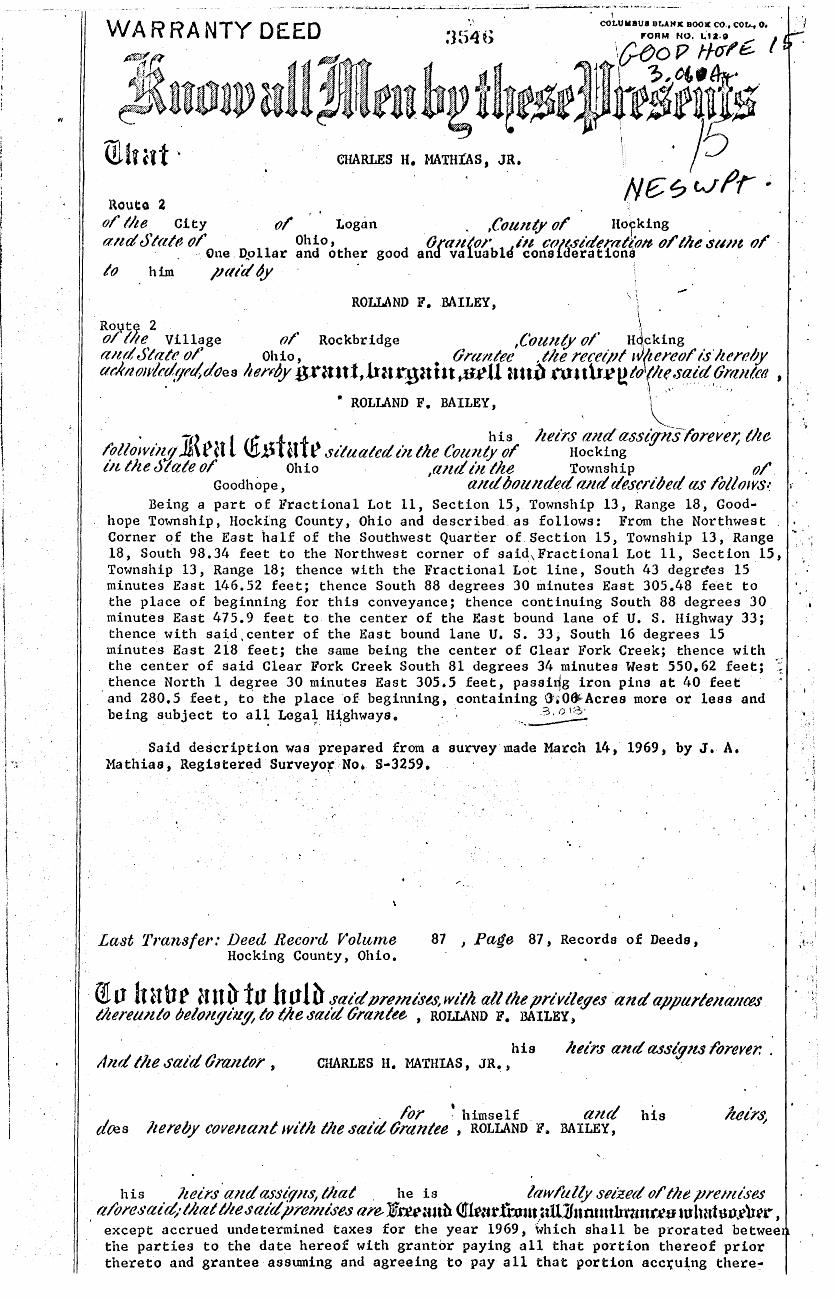
Route 2 ' .
ol lhe City ol Logan . ,County o/ Hocking . a11d Stat~ fJI' Ohio, Ora11torb11 i1t C{IJ,dt~ideri1-at~ote ol' the s1#1t o/ -
.. One. D..,ollar and other good and valua " consic erat ona . /(} him /Hllao/
\ \ ROLLAND F. .BAILEY, ; -Ro11t;Ci! 2 \ . o/ lite Village of' Rockbridge ,Coun(Y of" . H4
1cking ..
a1ut State or Ohio' •. Onutlee , tlte recetpl 1~~ereo/' IS ltereby at:lrn.owlr.r(.qrt/,d<Jes henOy g.nm t,h:u~gmtt ,S.l' u Utt~ roulr.ee to (1te,.said,6rmttcd I
• ROLLAND F. BAILEY, _ , ~- _
· -, l 1f! f f · · his lieirs a1tdassig-i£srorevet; tlte (ollowtli$]\rU ~l) H ~situated tit the Cott~tty o/' · Hocking lit t)u Jtate o/' Ohio . ,and ot t)te Township (}/'.
Goodhope, a1td bou1tded ruut descri/Jed as lb/lows.~ Being a part of Fractional Lot 11, Section 15, Township 13, Range 18, Good·
hope Township, Hocking County, Ohio and described. as follows: From the Northwest .. Corner of the East half of the Southwest Quarter of.Section 15, Township 13, Range 18, South 98.34 feet to the Northwest corner of said,Fractional Lot 11, Section_l5, Township 13, Range 18; thence with the Fractional Lot line, South 43 degr(!es 15 minutes East 146.52 feet; thence South 88 degrees 30 minutes East 305.48 fe~t to the place of beginning for this conveyance; thence continuing South 88 degrees 30 minutes East 475.9 feet to the center of the East bound lane of U. S. Highway 33; thence with said.center of the East bound lane U. S. 33; South 16 degrees 15 minutes East 218 feet; the same being the center of Clear Fork Creek; thence with _ the center of said Clear Fork Creek South 81 degrees 34 minute a West 550. 62 feet; .. thence North 1 degree 30 minutes East 305.5 feet, passirlg iron pins at 40 feet
, . I
and 280.5 feet, to the place ·of. beginning, containing G';OtJiAcres more or less and being subject to al~ Lega!. H~ghways. . · ·~-~
Said description was prepared from a survey·made March 14, 1969, by J •. A. Mathias, Registered Surveyor:No. 8·3259 •
. ,•
Last Transfer.· Deed Record Volume Hocking County, Ohio.
87 , Pade 87, Records of Deeds,
', I
·•
I.
i
I i
' '
i m v 1t ab~ anb- iu ltolh J'aidprevtiJ'ts,wltlt all the privt'leges 'and appttl'lell;llt'PS thereunto /Jelo1tf!lU!fa to l:lte '1ald Grantee , ROLLAND F. BAILEY,
. ~ ~;
his lulrs and a.sslgns fbrerer. . And the said (}ralltor , CHARLES H. MATHIAS, JR. ,
his dtes
. for ~ himself . and lie re by covenant with tlte salrt tJrantee , ROLLAND F. BAILEY,
his JUJirs 'and ass<"rpts, /}tat . he is law/ally sn'zed o/ tlte pre11tise.s albreJ~ai~· that tl1e said pre11lises are. Jff.ru:utb Qiku.tfhnn _,tU1Jnruttthtun.f.es tulnrhtn .. eh4't', except accrued undetermined taxes for the year 1969, ~hich shall be prorated betwee the parties to the date hereof with grantor paying all that portion thereof prior thereto and grantee assmning and agreeing to pay· all that portion acc~u~ng there~
---···---· r;,(}() /. / "!> I, ;II- '- •
JlJintn §urueyiug §cruicea, lJnc. PROFESSIONAL LAND SURVEYORS
20525 Buena Vista Road Rockbridge, Ohio 43149 (614) 969·4101
. ' PLAT OF SURVEY
SITUATED IN THE STATE OF OHIO, COUNTY OF HOCKING, TOWNSHIP OF GOOD HOPE, AND BEING ALL OF A O. 75 ACRE PARCEL OF LAND LOCATED IN THE EAST HALF' OF THE . NORTHEAST QUARTER OF SECTION 15, TOWNSHIP 13, RANGE 18 AS CONVEYED TO RUTH G. CAVE IN DEED VOLUME 215, PAGE 349, ALL RECORDS OF THE RECORDER'S OFFICE, HOCKING COUNTY, OHIO.
51. ,SERT W, c;f. L ~OA/A M&-RCGR
OEC!/J Yot.., /I~, ;£Jt;,. S/I
, I
The bearing system for this plat is based on the east line of Section 15, Township 13, Range 18 as· being N 0° 00' 00" E.
I hereby certify that this plat was prepared from an actual field survey of the premises in Augu.st of 1991 and from existing public records and that said plat correctly defines the limits of the parcel shown hereon.
All iron pins set are 3/4 inch diameter iron pipe 30 inches in length with plastic i\t@n~tH"····.:r'his certification was made by me on this if
. . ,, ... (': ,.. ... , 'r/' /') t icat1on caps. ,,.....~ .. ~, ·:-. .. ·:. 1• :)~qc?- day of _· rrovo ~ r= , 19 9 / .
l:,>·J:q·· "·a /)// • . . . i' { (. -~(J;W'4ru/ ~....,\"' .\': ... ... _.' 'yerry L. Cassell, Reg. Sur, 6378 ~~ .. ·-·~ /vCJ .... ),c,f " , . . _. ·t.· :
~C.4tt!: I":: ~0' .. ,., 'l/ (>·: .... ·. ':J ,/ '"•, •j v ~ '~ +----------------- -
,,,,,,, • .,," is-1• •''\
DESCRIPTION OF A 1.136 ACRE PARCEL OF LAND
Situated in the state of Ohio, County of Hocking, Township of Good Hope, and being all of a o. 76'" acre parcel of land located in the east half of the' northeast quarter of section 15, Township 13, Range 18 as conveyed to Ruth G. Cave (hereinafter referred to as "Granter") in Deed Volume 215, Page 349, all records of the Recorder's Office, Hock:ing County, Ohio and being more particularly descrilied as follows:
Commencing fo_r reference at the southeast corner of the northeast quarter of section 15, Township 13, Rangel8;
Thence N 0° 00' 00" E along the east line of section 15 a distance of 1186.01 feet to an iron pin set, said iron pin being the Grantor's southeasterly property corner and a property corner of a 1.07 4 acre parcel of land as conveyed to Lillian Standiford in Deed Volume 196, Page 200;
Thence N 21° 52' 31" w along the Grantor's southerly property line and the northerly property line of the aforementioned Standiford parcel a distance of 88.28 feet to a point;
Thence s 71° 00' 00" w continuing along the Grantor's southerly property line and the northerly property line of the aforementioned Standiford parcel a distance of 201.92 feet to a point (passing an iron pin found at 182.95 feet), said point being the Grantor's southwesterly property corner, the northwesterly property corner of the aforementioned Standiford parcel and in the center of Troxel Buckeye Road (Township Road ll8);
Thence along the Grantor's westerly property line and the center of Troxel Buckeye Road the follow:ing three (3) courses:
1) N 18° 23' 02" w a distance of 203.76 feet to a point;
2) N 16° 53' 21" W a distance of 67,31 feet to a point;
3) N 26° 26' 25" W a distance of 32.57 feet to a point, said point being the Grantor's northwesterly property corner and the southwesterly property corner of a 19.0 acre parcel of land as conveyed to Elbert W. and Leona Mercer in Deed Volume ll6, Page 5ll;
Thence s 61° 11' 13" E along the Grantor's northerly property line and the southerly property line of the aforementioned Mercer parcel a distance of 190.11 feet to a point {passing an iron_ pin found at 72.18 feet);
Thence N 87° 05' 54" E continuing along the Grantor's northerly property line and the southerly property line of the aforementioned Mercer parcel a distance of 155.76 feet to an iron pin found {passing an iron pin found at 30.83 feet), said iron pm being the Grantor's northeasterly property corner, the southeasterly property corner of the aforementioned Mercer parcel and on the east line of
__ Section 15; --- -------
Thence s 0° 00' 00" W along the Grantor's easterly property line and the east line of Section 15 a distance of 219.38 feet (passing an iron pin found at 118.84 feet) to the point of beginnmg, containing 1.136 acres, more or leffi, and subject to all legal eas~ments and rights of way of record.
The bearing system for this description :is based on the east line of Section 15, Township 13, Range 18 as being N 0° 00' 00" E.
All iron pins set are 3/4 inch diameter iron pipe, 30 inches in length, with plastic identification caps.
This description was prepared on August 15, 1991 by Jerry L. Cassell, Registered Surveyor No. 6378 for Vista surveying Services, Inc. and is based on an actual field survey of the premises and existing public records.
Approred • Mathematically i:"' H~unty Engineer's office
By \t Date ~ ... 17-~ I 'lt. - . I
-3 .. e:::::=:4G- A .9~-C OF F;;-:_Ac_. )-OT" /UO. /~ AA-i0 A PA:C::...-C- o,,-=-- \f-\.C_. ..Al\...f.J~ OF \A£ 5'rfjA Or . .s££. )5,
~:::> Ao;:::>.c.. \'WP> ~-)2:0-1, ..R-JBw,A~~~ c.o_, O-\Io
I >-1.W co;:_. QF ~A.E.- ...AJw jA.. · ~1 ·Dr- :~ .:Sw'/A. or= '5£,.f::_. j )-$, C.006 ;-J...o,..,,e:__ '"TWP.
r-1 • 11(. -, I rJ
~~ ~l· '( : o\,n 0 ~~ 'efl. ' .J
-~ vii' VJ 1 I) t
O' (( r::
~.i r
~
r--- . \[) ()' - I "l(l ~ .
---:i~ ~ r--Ji . <. ~ \~ ~ I'-'
'tv') '-1 0
'.~ ~ ~ fl g tl)
<f . ('{ « I
~ \J\
VOL.){!,(, A::...~~ ...
yoL-. )£>7, PC:..6-A..\
l····
I
'J
-~ ~ ~ \\l <") r<) I ~~
l ~ ()
.2-5. :$8"'13 Ac~-E:.S . (_ VoL. )C\C\,Y~--~3{) ..
vol-. J5<. S''t:: .... 3.
.Y. ~s.~
'VO)-. W?, ~- ~:i3.
OA ' v') · ~ ( ~'°,,-r-=-i F~ So-5':(r:-) < 2:>£.t>..~ ~ 6 °-4. \.. 6-r '.£.,.
~ ) 2.~ -~T1 .P-:::-. E~ CL»-.)
0 Aoo
~ 7~· 7.gc· , t<..'t'Fce_~ crv 0 $ f z: .'.!::~ ... oA.\ ;P=u <..~) /"" / ~ cAP
D "' ~)Q. .!'>.:?:ix:.e. (PD·)
A~;:i:-md - Mat!!ematically H.~ciling County Engineer's office
c1-1fl-l-p_n~te~-f' I
.9,L..A..~ 9~~;:::..::::, ~""'-- .5'-):Z...v£'
.i':-"/S~. 22 , )C\.8-4, bY' : .· ,,.------. "-......
~·/·)· __j;~r_:;, . ../~-.,. \
e == ~~<_r-o.'t
8 ~ s~P.~ 5'o~..._. (r:::::..)
DESCRIPTION OF SURVEY FOR THE COLUMBUS & FRANKLIN co~ METROJ?QLITAN PARK DISTRICT
Being a tract of land last transferred in Vol. 199, Pg. 757, Hocking Co. Deed
Records, situated in the NW~ of the SW~ and in Frac. Lot No. 11 of Sec. 15, Good Hope
Twp., T-13N, R-18W, Hocking Co., Ohio, and being more particularly described as follows:
Beginning at a R/R spike found at the intersection of the centerline of Co. Rd. No.
116 with the west line of said Sec. 15, said spike being referenced by the NW corner of
said NW~ of the SW~ of Sec. 15 which bears N 0° 56' 30" Ea distance of 535.43 ft.;
Thence with the center of said Co. Rd. No. 116 the following six (6) courses:
1) N 79° 34' 10" Ea distance of 174.16 ft. to a R/R spike found;
2) N 72 ° 30' 50" E a distance of 298. 32 ft. to a R/R spike found;
3) N 74° 23' 50" Ea distance of 731.29 ft. to a R/R spike found;
4) N 83° 06' 10" Ea distance of 112.75 ft. to a R/R spike found;
5) S 85° 52' 40" E a distance of 113.94 ft. to a R/R spike found;
6) S 84 ° 06' 03" E a distance of 221. 08 ft. to a point, said point b'eing the NW
corner of an 0.20 acre tract described in Vol. 157, Pg. 3, and being referenced
0 by an iron pin found which bears S 21 19' 37" E a distance of 56 .11 ft.;
Thence, with the west line of said 0.20 acre tract, S 0° 33' 47" E a distance of
450.38 ft. to a point on the south bank of Clear Creek, said point being referenced by
a steel fence post found which bears N 8° 41' 07 11 E a distance of 123. 77 ft.;
Thence with the south bank of Clear Creek the following eight (8) courses:
1) S 60° 29' 41" W a distance of 118.65 ft. to a point;
2) S 52° 30' 02" W a distance of 224.50 ft. to a point;
3) S 69° 17' 12" W a distance of 382.28 ft. to a point;
4) S 89° 41' 51" W a distance of 243.35 ft. to a point;
5) S 55° 1~5' 08" W a distance of 120 .19 ft. to a point;
6) S 52° 04' 40" W a distance of 160.95 ft. to a point;
7) S 76° 32' 20" W a distance of 173.68 ft. to a point;
8) N 79° 12' 57 11 W a distance of 347.79 ft. to a point on the west line of Sec. 15;
Thence, with said west line, N 0° 56' 30" E, passing an iron pin set at 96.38 ft.,
going a total distance of 621.98 ft. to the place of beginning, containing 25.5873 acres,
more or less, and being subject to the right-of-way of Co. Rd. No. 116 and all valid
easements.
Cited bearings are based on a previous survey and are for the determination of
angles only.
All iron pins described as being set are 1/2" X 30" with an attached plastic
identification cap.
The above description is the result of an actual survey made by Michael P. Berry,
Ohio Registered Surveyor No. 6803, on February 22, 1989.
Awoved · Mathematically !id.i:i~ Cot;nty Engineer's office
oY-fj/--l.f;_D<.te_Z -Z..B-111
,~-~LJ)Q~ ~. Michael P. Berry
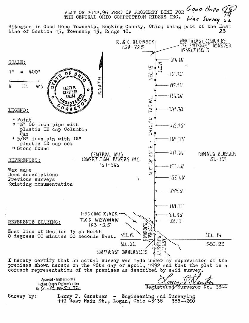
PLA'l' Oli' 2412.96 .VEE'!' 01 PROPERTY LINE ?OR Cqo() !-/ope <JP THE CENTRAL OHIO COMPETITION RIDERS INC• l/H e Ju""elf ~ ~
Situated in Good Hope Township, ·Hocking Oounty, Ohio; being part of the East line of Section 15, Township 13, Range 18. 2~
R.& k:. BLOSSER' 15'0-125
N DRT\\ EAST CDR~t.R ~f T~t. S~~\\\'N~ST Q\)~~\t.R ~~SELT\D~ \S
SCALE:
1" • 400'
LEGEND:
• Point o 1w• OD iron pipe with
plastic ID cap Columbia Gas
• 5/8" iron pin with 1/4 11
plastic ID cap $~t o Stone found
REFEHENCES:
Tax maps Deed descriptions Previous surveys Existing monumentation
-- J.\%,(,t'
~-l~l.11'
----- l~S .4~'
---11i.1i·
,____)JS .95 I
.....,___I btt .lY
----l\l.l~1
----- \'.)l.l,~'
------- \S~.~D'
--l'ft.SI'
REFERENCE BEARING:
--- I 64-.11'
H-"OCk:ING R\ Vt:!<.~~ '----~l.<f~' T.& D. NEW.MAW ~ ~\ \OD.\?l'
.::::lrl
R~Nl\L\) BLQ)~£R \Sl- j5~
103-15 ~ P' East line of Section 15 as North ~~ 0 degrees 00 minutes 00 seconds East. ~EL\i; ~~~~;r-"7--------SE_L_. \_l\ __
SEU.1. /~~'.'.:J SEC. 23
SO\ll\\tl\ ~T COR\JER m.15' r ~:::;"" I hereby certify that an actual survey was made under my supervision of the premises shown hereon on the 28th day of April, 1992 and that the plat is a correct representation of the premises as described by said survey.
Approved • Mathematically Hot: Coupty Engineer's ?ffice By~J~ Date 5-/-17.<.
t(
Survey by: Larry P. Gerstner - Engineering and Surveying 119 West Main St., Logan, Ohio 43138 385-4260
SURVEY DESCRIPTION OF 2412.96 FEET OF PROPERTY LINE FOR THE
CENTRAL OHIO COMPETITION RIDERS INC.
Situated in Good Hope Township, Hocking County, Ohio; being part of the East line of Section 15, Township· 13. Range 18; and being more particularly described as follows: ~
Commencing for reference at a point in the Hocking River at the Southeasl corner of Section 15 from which a 1-1/2" OD iron pipe with plastic ID cap Columbia Gas found bears South 0 degrees 58 minutes 50 seconds West at a distance of 276.54 feet; thence with the East line of Section 15 North 0 degrees 00 minutes 00 seconds East a distance of 280.52 feet to a 5/8 11
iron pin set and being the point of Beginning of the property line to be described;
thence continuing with the East line of Section 15 North 00 degrees 00 minutes 00 seconds East a distance of 2412.96 feet to a stone found at the Northeast corner of the Southwest quarter of Section 15, passing 5/8'' iron pins set at distances of 100.13 feet, 182.96 feet, 347.73 feet. 592.24 feet, 747.84 feet, 905.52 feet, 1122.78 feet, 1287.51 feet, 1503.46 feet, 1742.78 feet, 1881.06 feet, 2026.96 feet, and 2194.28 feet and being the end of the property line to be described.
The above 2412.96 foot long property line survey is intended to describe part of the boundary of a tract of land as deeded to the Central Ohio Competition Riders Inc.. deed reference Volume 157, Page 585, Hocking County Recorder's Office. This survey was based upon information obtained from tax maps, deed descriptions, previous surveys, and existing monumentation. The reference bearing1 for this survey is the East line of Section 15 as North u degrees 00 minutes 00 seconds East. All iron pins set by this survey are capped by a 1-1/4 11 plastic identification cap. The above described property was surveyed by Larry P. Gerstner, Ohio Registered Surveyor No. 6344, on April 28, 1992.
----tif 7-[7~--------Approved • MathematicaHy
Hocking County Engineer's office By ~l If Date S: 1--ftc.
Survey by: Larry P. Gerstner - Engineering and Surveying
119 West Main Street, Logan, Ohio 43138 385-4260
~tc. \b.
w. ~'-A'' ~ 1'.5'7"~ ., • >
I f. J I -· 5 t • () ,50' ·-· z-· JOO
j }'C..5H~t'T\ - •1.•·t.#-'A,._tS VO'- S•"L "-- ,~, / --
270'3. ~·
~ 3~.72.2. Ac:..ttE~, -ro~A1..
-~----........._-~-- c~-------
,. , .. '. '"""'-· '~ ,,..
T !- .... "
I ..
---- N ~~0 ss· 57..'' W --t\
,,,."' r ,_ •
..!. "'
A,,__ ?~vi. ~ S\.4Af\.Ul "',.. "'w \'•c..111 PC.."1.~
--! ,-~ ~'"'"l• U~IU v- "" pa.~11
...... ,, .... ~t 1
~-~ '. ~t·~'1. fot.N~t. I. - - ~.I)' llA\.~ 'at~,,,_. ... , .. t -: :! ,,, NO-ft.: "Ti.+£ A6~1Jt. 'af"f'.H~"S AM 6A5tO O~ \.\Oc.-.1.,.~ C:..O, '~~\-.,1£4.0 c.o.
J(' ~_Pp:uved - Mathematically
H~ll: Er.gineer's office
\..1\.1\ ~t.1wc. ~ ... c~~~-v.at~~ 1.ttiol~,"f~~ t.OU.,..,."f~IW~ ~CT"'°'t.t."'
~E:c.11•..» 1S ~oc."u~c. c.o. :l. $tC1to~\O "°''~fltt\O 40, ~ Cu\.S. ( Y:flAtUL\.1..:I eO. M(1'. t"A~1&.. P•\'"Tf\l'i ~~~.lr')Jlc"'~~
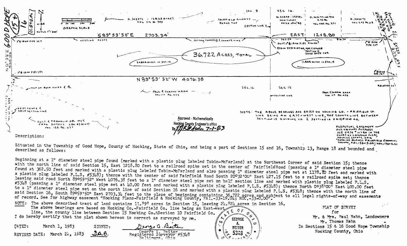
>/•'- IS~ 9C.. \d ., 8r ~~ Z-l-B-;, Description:
f\.\\~~.,..VA\. ~A'St.Mt.\l"T <F•f\.11~"'""'111\., Put\Po~E:~ .He. ~~ 't •It., tao !Iii ~C C•uf'.i .,. C.0""""•~ 4'\.\A~ "". ,.,~, c.••"'" 6 .. "
'HdC...•r..JC ~AMj;_ ,..A\-.-ll\.O /~NC.
Situated in the Township of Good Hope, County of Hocking, State of Ohio, and being a part of Sections 15 and 16, Township 13, Range described as follows:
C.OUM""f., ~A\.•'31•\,.o+; Moc.;,~6.00
18 and bounded and
Beginning at a l" diameter steel pipe found (marked with a plastic plug labeled Tobin-McFarland) at the Northwest Corner of said Section 15; thence with the north line of said Section 15, East 1218.80 feet to a railroad spike set in the center of FairfieldRoad (passing a l" diameter steel pipe found at .362. 50 feet and marked with a plastic plug labeled Tobin-McFarland and also passing 1" diameter steel pipe set at 1178. ·a, feet and marked with a plastic plug labeled P.L.S. #5348); thence with the center of said Fairfield Road South 200)2'00" East 427.15 feet to a railroad spike set; th~ce leaving said road North 89059•52" West 4076.)8 feet t-0 a l" diameter steel pi:pe set on half section line and marked with plastic plug labeled P.L.S. #5348 (passing a l" diameter steel pipe set at 40.00 feet and marked with a plastic plug labeled P. L.S. #5Jh8); thence North 0038 '00" East 400 .00 feet to a 1" diameter steel pipe, set on the north· line of said Section 16 and marked with a plastic plug labeled P. L.S. #5348; thence with the north line of said Section 16, South 89059'50" East 2703.34 feet to the nlace of beginnin~ containing 36~J22 Q~re~ and_s~bject to all legal rights-of-way and easements of record. See for highway easel'T'ent "Hocking Plans-Fairfield & Hocking Coun ... y, F'AI.-33-19.u'J; HOC.-JJ-O.oo •
NarE: The above described tract of land contains 11.R9P acres in Section 15, leaving 2h.8~~ .. ~1,;,es in Section 16. The above bearings are based on Hocking Co. -Fairfield Co. line being an East-Wes~ .. ,,''t o F .,,,,,,, line, the county line between Section 15 Hoc king Co.!:Section 10 Fairfield Co. ~ ......... '\~. : .. •••••·•·• ... o ;,'\.,
I do hereby certify that the plat shown hereon is correct as surveyed by ne. ~ A../ SEORGE •• •• / \ ~Ct): A ·.o:
Q ~ ; '· € BEJTER 1 :. ~~ •
0 It ;. •:.~ s~"'s ~:· t· ~or ~ :. • _ e er#5348 ~ .. (f' ~,. , _ _ : _: Regisuerea ~urveyor , _ ~ _ 3rl1tiMo~e. O~io ~- tr'··-", - - -:::~.·I"\ .'
REVISED DATE:
srmrnn: ~.e.
March 1, 1983
PIA T OF S tJRVEY for
~. & M?-s. Paul Hahn, Landowners ~. Thomas Hahn •
In Sections 15 ~ 16 Good Hope Township Hocking County, Ohio
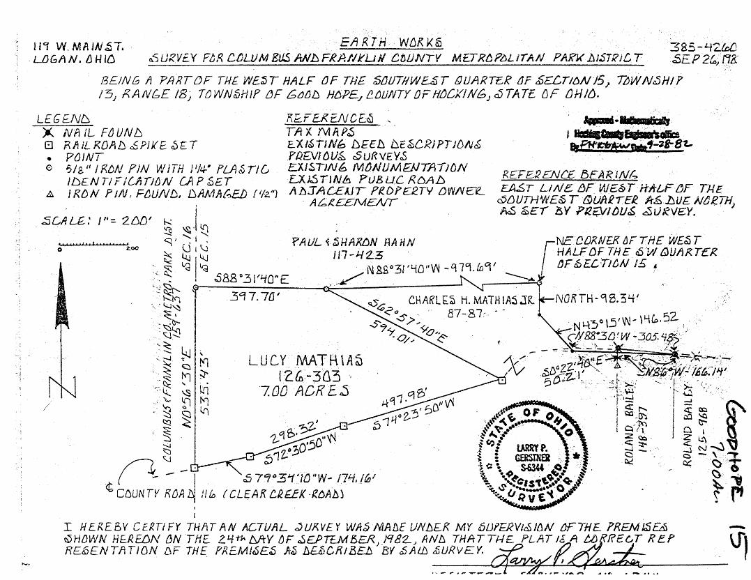
· ~T EARTH- WCJK KS ucr W. MA JN OJ • . 385-l-12.ldJ . LDGAN. LHllCl o.'SURVEY FtR Cul.UM Eli!J ANlsFkP.llkLJJ.l CfJIJNTY M£TJ?6P~LrrAN PARJ(])J~TRiCT SEP 2~:,tJB:
BEING t1 P/1RTDF THE w£:;r HALF OF THE S/J/JTf/WE~T ()UARTER gF t6ECTltJNJ5_, ~WN~HJ? 131 F.ANbE 18) TjWN&iHIP tJF 6tJIJ!J H6P£./f!_tJUNTYOFHtJCKIN6J~TATE DF {)H/(J. -
LEG EN~ 'A NAIL F[JUNb B F\IULRDAfJ ~PJKE ~£T • PtJINT 0 ~/g," I f<{)N ?JN W iTH J 1/4-" PLA & Tl G
JDENTIF/lltTl!JN CAPSE.T ~ I/?./) N P 1/V, Ft;UN D, uAA1AC:.EJ) ! '12.")
/
I
I
R'f-FE.RENC£~ .. TAX rvtftP~ EXl~TJNb bEEh i::JESCRiPTJD/\Jc£ .Pfl£VJDV~ cSuRVEY'5 . E...XISTJN~ MtJNUMaJTAIJDN E.:XJ5TJNh PUBUC RDAlJ lth:IAC£JJT F'fDPER..TY DWIV~e_
- A£,£££/\AENT ,
R£FE12ENC£ 13EARJN(., EA.ST LIN£ f)F. WE&T H1U,,F{jF TJ./E
cY!JUTHWES T &UFtR.IEi lt~.1JU£ N~R.THJ M &~r "/5Y Ptl~l~U~ d5URVEY.
I H EREBV CEl!.TI FY THAT AN ACTUAL .JURVE Y WA~ NlAnE UNJJEK MY 6lJPE.RV1~JfJN /JFTHE ?REM/$£& ~H/JWN HEREDN (JN THE 2.. 4-t}. /YtY IJF ~£.PTEM 5ER) )Cf 82-.> AN!J THAT T/.-1£ PLAT 16 A t.lJ RE 6T R eP RE&JENTl1TION !JF THE_ PREIV!J~E~ It~ hUiCl11BEh BY cfilt/JJ .f;URVEY.
EARTH WORKS
119 w. Main st. Logan, Ohio
38.5-4260 September 26 ,, 1982
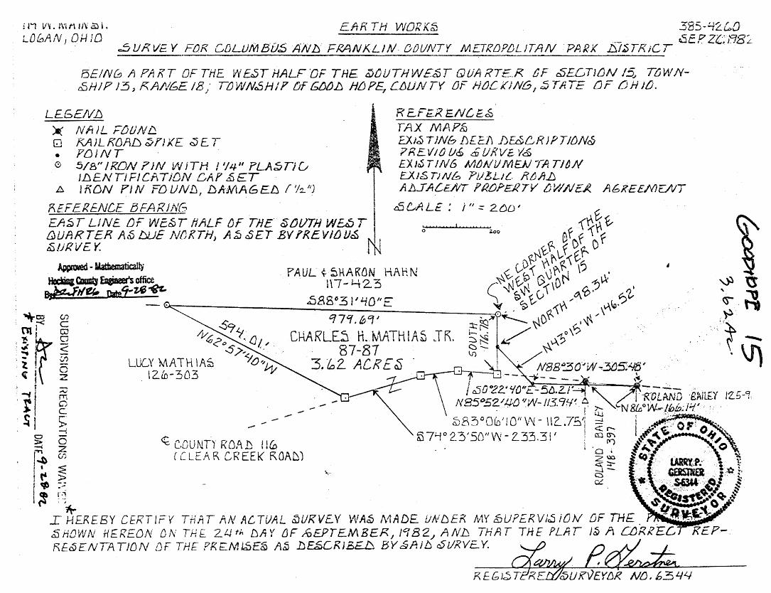
DESCRIP'rIQN OF ?,QQ AQRE SURVEY FOR COLUMBUS AND FRANKLIN COUNTY MErROPOLITAN PARK DISTRICT
Situated. 1n the Township of Good Hope, County ot Hoek1ng
and State of Ohio; being a part of the West.Half of the South
west Quarter of See ti on 15 ,. Townsh1·p lJ~ Range 18; and being
more partioularly described as followsi
Commene1ng for reference at a 5/8" iron pin set at the
Northeast Corner of the West Half of the Southwest Quarter of
said Seotion 15 wh1oh ls further referenoed as being the fol
lowing three bearings and distanoes from a nail found 1n the ·
oenter of County Road 116,, Clear Creek Road,, as set as the
beginning point of a Mareh 14,, 1969 J .06 aore survey <lone by
J.A.Math1as tor R&lland. F •. Balley, deed reference Volume 125,. ··
Pa1e 968 Hooking Ceunty Reoorder's Otf1oe, North 88°30 1 West
305.48 feet; thence North 43°15• West 146.52 feet; thenoe
North 98.34 feet to said ccmmenoing point; thenoe Nerth 88031 140"
West 979.69 feet to a 5/8" iron pin se~ and the point ot Begipnlng
for this survey; thenoe South 629 57'40" East 594.0l feet to a
railroad spike set in the center Gf said County Road 116; thence
along the center of said County Road 116 the following three bear
ings and distanoes, South 74°23•50" West 497.98 feet to a railroad
spike set; thenoe South 72030•50" West 298.32 feet te a railroad
spike set; thenee South 79°34 110" West 1?4.16 feet to a railroad
spike set; thenoe leaving sa1a County Road 116 center North
0°56 1 30 11 East 535.43 feet to a 5/8" iron pin set in the Northwest
-- Page 2,, 7.00 aore survey for Cols., and Fran. Co. Metro Park --
eorner of the Southwest Quarter of said Seetion 15: thenee S&uth
88°31 1 40 .. East 397.70 feet to the point of beginning containing
7.00 acres more or less, suojeet to the public easement of said
County Road 116 and any private easements of reeord.
The above 7.00 aore survey de~or1pt1on 1s intended to be all
of a traot of land belonging to Luoy Mathias, deed referenoe Volume
126,, Page JOJ, Hoeking County Recor••r's Oftlce. This survey was
based upon 1nfermat1on obtained from tax maps, existing deed des-
or1pt1ona, previous surveys, existing monumentation~ an existing
public road, and as agreed upon by·adjabent property owners. The
referenoe bearing for this survey ls one set by a previous survey
making the East line of West Half of the Southwest Quarter as due
North, All iron pins set by this survey are capped by a lt~ plastle
1dentif1oatlon eap. The above described property was surveyed by
Larry P. Gerstner, Oh1o Registered Surveyor No. 6J44, on September
24. 1982.
Approved. Mathematically HQck1oa CounQ En&ineer's office
aAWfN '" Date1 ... VJ- 8 ~
i f1 VV. :\uUN ~ L
L00AN, 01-JJD EFtR TH WORK~ 385-42.loO
s - P' Zl,-- 'RB' c5VIZVE Y FOIZ CDLUMBU~ AN.ls FRANKLIN. DOUNTY METRDP/JLITAN 'PARK .iS/fJTF<;CT ~t:i. ~J, L
BEIN& 11 PAKT OF THE WbST HALFDF THE ~tJUTHW£~1 QUARTE_R CF ~ECTJ/JN I~ TL)WN-cEJH/P 13, KA/tl6E 18/' TuWNcSH/17 tJF ~.!J HDP~ CtJUN TY OF 1-ioCKiNG,:;; TATE tJF LJH JLJ.
LE6Ell/.fJ ~ Nft)L F!J!JN~ GJ f<.AJLKOAIJ ~TJKE ~ET • f'[JJNT -0 5/B"ll?ON f'JN WITH / 1/J.J. 11 PLA.:;;Tiu
JJJENTIFICATI01V CAP .SET A if\DN PJN ;-DUN!J, !JlrMAG~IJ f 1h. 1
']
REFE.Rf!VCE 8FARJNG EA~T LINE.. DF WE.~T ttALF uF Tf/E. ~lJIJTH WEtfJ T ~UARTER Al5 DUE NDKTH; Ati ~ET BY ff<EVICJIJ~ NI ~!JRVE Y. - i N
R £Ft;_R 'E.NC/E..~ TAX MAP!iJ EX.i~TJNb f)f_Efl Dw6RJPTJON& 7REV1tJU<£ .£UIZV~ V& EXJ~T!N6 M/JNiJM£JJTATldN £.XIS TJNb PiJbLl{... R~A.D AJJJALE/VT PROPEJ.?TV oVl/i/£.1?. At;;KEEMENT
tl56ALE: i II:::: 260 I
0
Approwed - Uatbematically
HPitl <:cmQ &giDeer's office ejr:Jllet- nate'i-VS -tflT..
PAUL{. ~l1ARDN HAHN l\7-l-t2.3
-<t C.O U NTY R OPd~ I ! fu
fJE8°3 i ''-10'' E q1'1.lbCf 1
CHARLE~ H.Jv\ATH IA~ JR. 87-87
3.lCJ2- ACRE~
-f CLEAR CR EEK ROAD1
~RTH WORKS
119 w. Main st. Logan,. Ohio
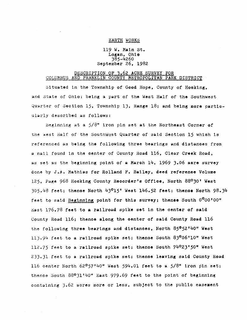
)85-4260 September 26, 1982
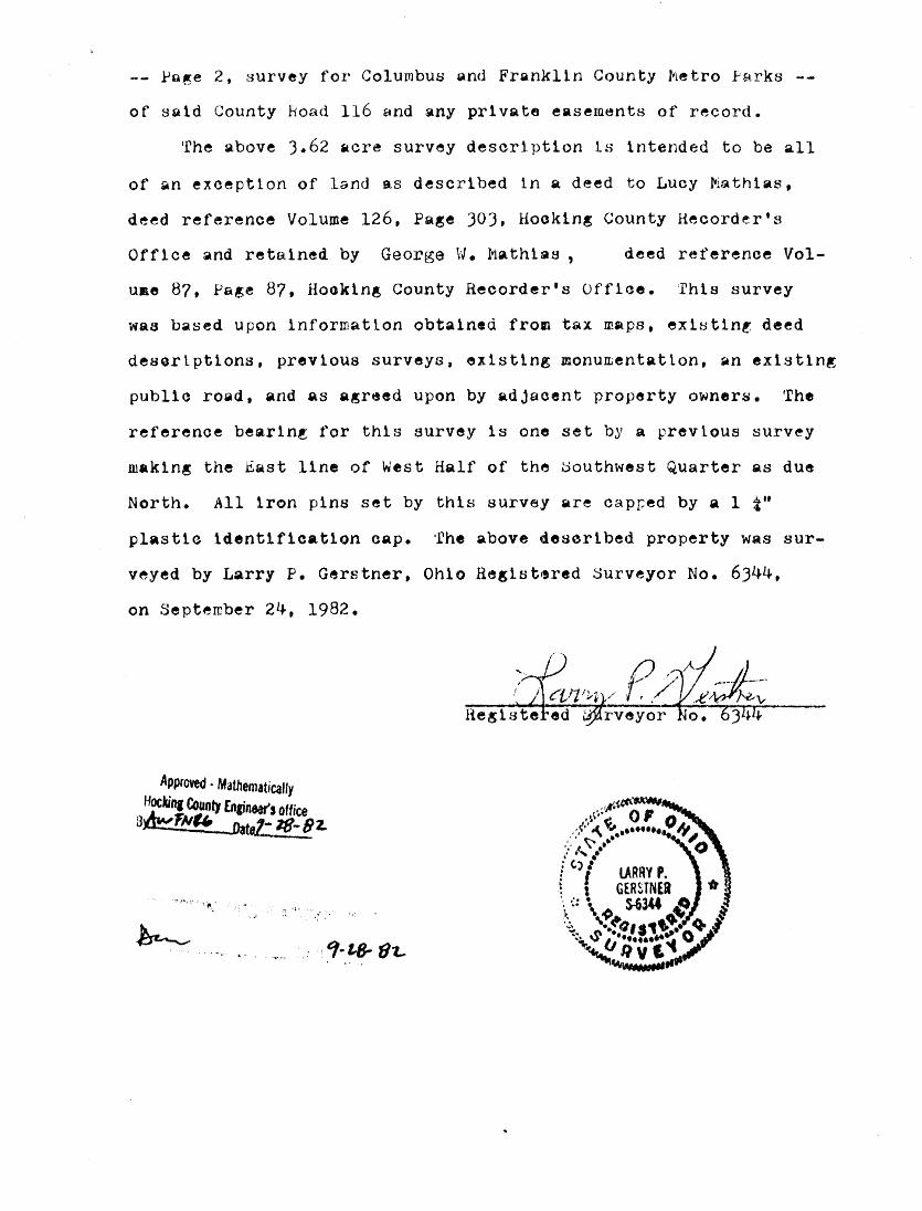
QESCRIPTION OF J162 ACRE SURVEY FOR COLUMBUS AND FRANKLIN COUNTY METROPOLITAN PARK DISTRICT
Situated ln the Township of Good Hope,. County of Hooking,
and State of Ohio; being a part of the West Half of the Southwest
Qu~rter of Section 15, Township 13, Range 18: and being mor8 part1e-
ul~rly described ~s follows:
Beginning at a 5/8'' iron pin set at the Northeast Corner of
the ~est Half of the SouthWest Quarter of SQ1d Section 15 whieh is
referenced ~-s b•tn~ the following three bearings and distances from
a n~il found in the center of County Road 116, Clear Creek Road,
as set as the beginning point of a MQreh 14, 1969 J.06 aere survey
done by J.A. Mathias for Rolland F. Bailey, deed referenee Volume
125, Pa~e 968 Hocking County Recorder's Office, North 88°JO' West
305.48 feet; thenoe North 43°15• West 146.52 feet; thenoe North 98.34
feet to said Beg1nn1ng point for this survey; thenee South o0 oo•oo"
Esst 1?6.78 feet to a railroad spike set in the center of said
County Road 116; thenoe along the eenter of said County Road 116
the following three bearings and distances,. North 85°52 1 40" West
11). 91+ feet to a ratlroad spike set: thenoe South 83°06•10 .. West
112.75 feet to a railroa.d spike set; thence South 74°23'50" West
233.31 fe1tt to a railroad spike set; thenoe leaving said County Road
116 center North 62°57•40 .. West 594.0l feet to a 5/8tt iron p1n set;
thence South 88031•4ou East 979.69 feet to the point of beg1nn1n~
conta1nin~ 3.62 aeres more or less, subjeet to the public easement
~n~e 2, survey for Columbus Qfld Franklln County Metro Parks
of sald County Road 116 Qnd any private easements of record.
The above J.62 ~ere survey description ts intended to be all
of ~n exceptton of land as descr1bed tn a deed to Lucy MQthlas,
deed reference Volume 126, Page JOJ, Hooking County Hecorder•s
Off lee and retained by George W. Mathias , deed reference Vol-
use 87, Page 87, Hoek1ng County Recorder's Offioe. This survey
was based upon lnformatlon obtained from tax maps, ex18tlnt deed
deaerlpt1ons, previous surveys, ex1sttng monumentatlon, an existing
publ1a road, and as agreed upon by adjacent property owner~. The
reference bearlni for this survey ls one set by a prevlous surv~y
making the East line of West Half of the ~outhwest Quarter as due
North. All 1ron pins set by this survey are ca.pr:ed by a 1 t"
plastic 1dent1f1cat1on oap. The above deserlbed property was sur
veyed by Larry P. Gerstner. Ohio Regist•red ~urveyor No. 6344,
on September 24, 1982.
Approved · Mathematically
~Ill 1'4uo1J fn&inWs office B 1N"'1 aatel• 18-81..
~~- . ; . ' I' ,,
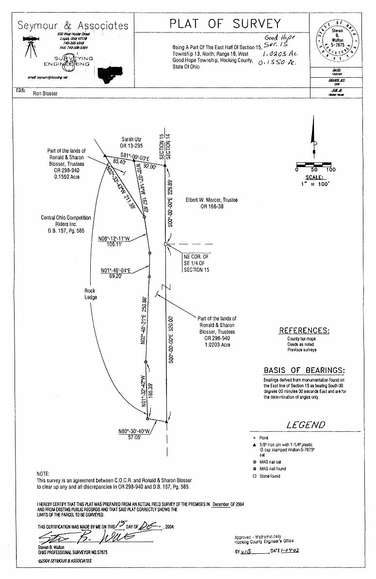
Seymour 8f: Aps1
09iates 8:JQ We,st ~ STptJI
~ l~JI I I\ fM:· 14~954
suQ1
YING ENGl~ING
Ron Blosser
Part of the lands of Ronald & Sharon Blosser, Trustees
OR 298-940 0.1550 Acre
Central Ohio Competition Riders Inc.
D.B. 157, Pg. 585
NOTE:
Rock Ledge
""'
N08°-12'-11"W 106.11 1
N01°-46'-04"E I
NB0°-30'-40"W 57.05'
PLAT OF SURVEY ........... ·o··;--· ...... ,•'\ \. ......... "+"· /'" •• ••• Sf even " ... ,,\_
6..'C1..~ //o/)~ Being A Par1 Of The East Half Of Section 15, 5,r. 1 S
f~! B. ". 0\
i. i Walton : • E
Township 13, North; Range 18, West /, tJR03 l·k l.,.~ ... S-7675 ..,i f .......... , \. ...... ""/ -..~'.,IS 1 \ .. ·~ .:
"·····~.:.::r.::.{:.'.\··/ Good Hope Township, Hocking County, 0 I I s s~o Ac. State Of Ohio
~'~ a1a i= i= (_) (_) UJ UJ (/) (/)
\
UJ
~ 8 o' 0 0 (/)
w
8 8 o' g (/)
)
Elbert W. Mercer, Trustee OR 166-38
NE COR. OF SE 1/4 OF SECTION 15
Part of the lands of Ronald & Sharon Blosser, Trustees
OR 298-940 1.0203 Acre
0 50 100 SCALE;
1·· = 100·
REFERENCES: County tax maps Deeds as noted Previous surveys
BASIS OF BEARINGS: Bearings derived from monumeotation found on the East line of Section 15 as bearing South 00 degrees 00 minutes 00 seconds East and are for the determination of angles only.
LEGEND o Point • 5/8" iron pin with 1·1/4" plastic
ID cap stamped Walton-S-7675" set
© MAG nail set @ MAG nail found
o Stone found This survey is an agreement between C.O.C.R. and Ronald & Sharon Blosser to clear up any and all discrepancies in OR 298-940 and D.B. 157, Pg. 585.
I HEREBY CERTIFY THAT THIS Pt.AT WAS PREPARED FROM AN ACTUAL AELD SURVEY OF THE PREMISES IN December OF 2004 AND FROM EXISTING PUBLIC RECORDS AND THAT SAID PLAT CORRECTLY SHOWS THE ---LIMITS OF THE PARCEL TO BE CONVEYED.
THIS CERTJACATION WAS MADE BY ME ON THIS/ ~AY OF ~" , 2004.
Staven B. Walton OHIO PROFESSIONAL SURVEYOR N0.$7675
(C)2004 SEYMOUR & ASSOC/A TES
Approved - Mathematically Hocking County Engineer's Office
6Y w1/3 DATE I· o 'NS.
/
EXHIBIT ''A" l.0203 ACRE TRACT
Being a part of the tract of land that is now or fonnerly in the name of Ronald & Sharon Blosser, Trustees, as recorded in Official Record 298 at page 940, Hocking County Recorder's Office, said tract being a part of the East half of Section 15, Tl3N, Rl8W, Good Hope Township, Hocking County, State of Ohio, and being more particularly described as follows:
Beginning at a stone found on the Northeast comer of the Southeast quarter of Section 15, thence along the East line of Section 15, South 00 degrees 00 minutes 00 seconds East a distance of 520.00 feet to a 5/8" X 30" iron pin with a 1 1/4" plastic identification cap stamped "Walton-S-7675" set~
Thence leaving said section line and along the Grantor's South line, North 80 degrees 30 minutes 40 seconds West a distance of 5 7. 05 feet to a mag nail found~
Thence along the Grantor's West line the following four courses: 1) North 01 degrees 32 minutes 42 seconds West a distance of 165.39 feet to a mag nail
found~ 2) North 02 degrees 48 minutes 21 seconds East a distance of250.86 feet to a mag nail set~ 3) North 01 degrees 46 minutes 04 seconds East a distance of 69.20 feet to a mag nail found
and 4) North 08 degrees 12 minutes 11 seconds West a distance of 106.11 feet to a mag nail set~
Thence with a new line through the Grantor's land, North 10 degrees 07 minutes 14 seconds West a distance of 167.40 feet to a 5/8" X 30" iron pin with a I 1/4" plastic identification cap stamped "Walton-S-7675" set on the North line of the Grantor's land~
Thence South 81 degrees 00 minutes 00 seconds East a distance of 92.00 feet to a 5/8" X 30" iron pin with a 1 1/4" plastic identification cap stamped "Walton-S-7675" set on the East line of Section 15~
Thence along said East Section line, South 00 degrees 00 minutes 00 seconds East a distance of 229.89 feet to the point of beginning containing 1.0203 acres, more or less, and subject to all easements of record.
The bearings used in the above described tract were derived from monumentation found on the East line of Section 15 as bearing, South 00 degrees 00 minutes 00 seconds East and are for the determination of angles only.
The above described tract was surveyed by Steve B. Walton, Ohio Professional Surveyor No. S-7675, in October of 2004.
" l
Dated
,l.pM• r ~ ~.~!3.thematlcally
Hock1n~ "'~ .. ,:1, r:::grneer's Office
6Ywp CATE OJ ·<J'to.5
/
I EXHIBIT"A" 0.1550 ACRE TRACT
Being a part of the tract of land that is now or formerly in the name of Ronald & Sharon Blosser, Trustees, as recorded in Official Record 298 at page 940, Hocking County Recorder's Office, said tract being a part of the East half of Section 15, T13N, Rl8W, Guod Hope Township, Hocking County, State of Ohio, and being more particularly described as follows:
Beginning at a 5/8" X 30" iron pin with a 1 1/4" plastic identification cap stamped "Walton-S-7675" set on the Grantor's North line, said pin being referenced by a 5/8" X 30" iron pin with a 1 1/4" plastic identification cap stamped "Walton-S-7675" set on the East line of Section 15 which is 229.89 feet due North of a stone found on the Northeast comer of the Southeast quarter of Section 15;
Thence South 10 degrees 07 minutes 14 seconds East a distance of 167.40 feet to a mag nail set on the Granter's West line;
Thence along said West line, North 32 degrees 33 minutes 43 seconds West a distance of 211.38 feet to a 5/8" X 30" iron pin with a 1 1/4" plastic identification cap stamped ''WaJton-S-7675" set on the Grantor's North line;
Thence South 81 degrees 00 minutes 00 seconds East a_ distance of 85.40 feet to the point of beginning containing 0.1550 acre, more or less, and subject to all easements of record.
The bearings used in the above described tract were derived from monumentation found on the East line of Section 15 as bearing, South 00 degrees 00 minutes 00 seconds East and are for the detennination of angles only.
The above described tract was surveyed by Steve B. Walton, Ohio Professional Surveyor No. S-7675, in October of 2004 .
. ~Jf,W~ Steven B. Walton, S-7675
Approved - Mathematically Hocking County Engineer's Office
av we
"' ~ ::: \i
~ -is~~ ~ "" ~ \J ~
~" ~ CJ'\ • .......
BASIS OF BEARINGS: MARCH 2002 MAGNETIC
DA YID & LOIS BONNORANT 161 - il 24.53 AC.
PLAT SHOWING SURVEY OF A 1.8365 ACRE TRACT FOR MICHAEL SPRINGER
l- . ---·
BEING PART OFjA 1.12 ACRE TRACT,
~ ~0·~
' . 0 4J ~ ,.
P.0.B. S.E. COR. of S.E. QTR. of S.W.QTRof SEC. 15
'5' /oa
~0'<'<0·· 2/~B~ty
I 8305 AC.
()
C)
ti N
N. II 0 11'44 .. W.
~
~,~~ ~ .
~~ () ..........
~
COLUMBUS & FRANKLIN CO, METRO. PARK DIST. 213- 250 48.33 AC.
PAUL & SHARON HAHN 107 - 508 54.12 AC.
Approvt;L• ~.tttr;rn;:i'll'Jli) Hocking County 1 ng1neer's Ott1ce
D.V. 107, PG. 5~8.h.F I c. LOT 3 PT., SECTION 15, T13, Rl8, Gov HOPE TWP., HOCKING CO., 135.85' _,
8Y -ff .~R . DATE _5_:::_2--0 Z-
STATEOFOHIOl I I
, ......... . ,,,, G OF •• ,,
... ~ '~" 0.1..'' , r~~ ••••••••••••• .-7/,o'' .. § -~.-·· .!A.'-'ES •••••• \ : * I R1CHARD ·: * ~ z: : l'&.;.m..,'"'l'.-U'! : : : ~ ""~,..,.~ .. : : :. .'() •• ~ S-7436 : ~ :: -:.~".;r~ Q/ c~ ~ OA··. o,sn;.~~-· ,~ ~ ..... (-s. ··••·•••··•• ~'V ......... ..... !'!!n~\.. c;~ ,,,, ... ............ , ..
/::; :./:t:GIIT date: 4 JD DZ
OHIO REGISTERED SURVEYOR #7486
~ LECJGND ,..-____,1
e = 5/8" REBAR SET WITH PLASTIC I.D. CAP o= P.K. NAIL SET
() ~0 /ZO /80 Z40
SCALE IN FE-t=T
N 44° 33°/0.'W. 70. t;,/'
THIS SURVEY WAS BASED ON INFORMATION TAKEN FROM DEEDS, TAX MAPS, AERIAL PHOTOS, TOPO MAPS AND EXISTING MONUMENT ATION FOUND.
REAL ESTATE DESCRIPTION
FROM: Paul and Sharon Hahn
TO: Michael Springer
The following REAC-EST A TE situated in the County of Hocking in the State of
Ohio and in the Township of Good Hope and being bounded and described as follows;
Being part of a 54.12 acre tract, D. V. I 07, page 508, Fractional Lot 3, Section 15,
Tl 3, RI 8, Congress Lands, and being more particularly described as follows;
CAP Beginning at a 5/8" rebar set with plastic l.D~ said rebar marking the Southeast
comer of the Southeast quarter of the Southwest quarter of said Section 15, said rebar
also marking the principal place of beginning of the tract herein to be described;
Thence South 78 degrees 31 minutes 57 seconds East 266.39 feet in the South Section
15 line to a 5/8" rebar set with plastic 1.0. cap;
Thence North 13 degrees 15 minutes 53 seconds East 197.46 feet leaving said Section
15 line to a 5/8" rebar set with plastic I.D. cap;
Thence North 44 degrees 33 minutes IO seconds West 70.61 feet to a 5/8" rebar set
with plastic l.D. cap;
Thence North 11 degrees 11 minutes 44 seconds West 135.85 feet to a P.K. nail set
in the centerline of Township Road #129, passing a 5/8" re bar set with plastic I.D. cap
at 115.69 feet;
Thence South 73 degrees 02 minutes 42 seconds West 189.92 feet with the centerline
of said Township Road # 129 to a P .K. nail set;
Thence South 10 degrees 20 minutes 26 seconds West 271.85 feet leaving the
centerline of said Township Road # 129 to the principal place of beginning, containing
1.8365 acres.
Basis of Bearings: March 2002 Magnetic
This description was-prepared from an actual survey performed by James R.
Cartwright, Ohio Registered Surveyor #7486.
/
Appr?veo - Mathematically Hocking County Engineer's Office
UY -,ti~B._ IJA1 /; .X:;:?_-02....
J mes R. Cartwrig t Ohio Registered Surveyor #7486
c L.
.-.;:,· ,· ~,·/
.. ,, ·.
·--. ~---------------~-~.12~1s£
·. ·~~· . ... tJ<', ,{'~4.!
lf'
395 I
·;· • .,..,,A.,..,.~,.. •.. -.... · .l~i~;~.--.· ... ..-.1 ....... -:···-~., ... ::-;;-·:-:· :~.--::-· .. ·.·.·, ··.·--:·_'i:-.,"'.· ••. ·.~.:: ~ .• ·. T~.· .. ~· ..• :r.·c .. cs:,·.--.... 7·· --.*>.. ... -.,.i),~~.;·::+.:~~...._-~·}-..~"~ .;:.;-'.·~~~-'f-)o:::~-· ·.~~~ ~ • r -"!.~-·.~ " ,...-., • ~ • ~~:'.""- ~ T ~
l ,. •• "~-·
.:;_-::~:;\
'' . "2' t:. -'-. ~- ) " "':;:·<~~- ~;:~r.,,
,' .• .-~· -:'.·· f,, ·• ) .• •;>
//5~·:·h~ :c : . :; .. ~· '
\ \
' .
.~~-'~....-......---~-----::--::;:.._;---~ --:::--.....,......_ __ _ . 1--· -··----------------! i
~·-· ------------------------------------------------------------·"--·-------··--~----·------· ... -·-_,.,·----···--·- ··--.·-··~---·------··.
' • ·-·~-·--,,~-·----- ~ ..__,~.,. .. , ---·~-'"'-'" ,_,,._,........., ....... ~,,, -----~ __ , . ._,._._.- .. ..___ .. ..-.. _...,,_,.,, '"" ..- ---~r_, .. _..__.__._.._,.,,,_,___,.. .. _.,..., __ .,......_.,,. __ ..__ __ ..__. __ ._.~..- .. ~-~-~---~-
, .
Of s'e<:b~n Nu I~
Che f'la"l .. ')/,owS
su~ver--or.lot- Na 1JE/Jart __ a-r_.lat-1Yo
'rf' l..J R 15>. /to C!k eo
the a.c::.c,,-~7-:. Ca1culafoL b;- lat~Pef'(' ... _ J\ _>'s._tl,c .. N.E .. <!.ot-.SEf_Sec.NoJy ___ _
;' <!e ~,t/t-r--t /, ~ ;or~:; 01n7--?la t-__ a11cl cJ, t rc>-lpb'on __ to_te- __ _ ~ 11.~ 'a {ru(" c!..of'r Of th .. Sur l/~r
dune. /f:~/~-/Q/7 t;Ph Sha.IV .C'o, S'u1-l"'J-C1-,/" 11'
-- .. -·--··-----.. ---- ... --. -··~·-·------------ .... -~--~--- -- ----·---------· r .. -- --
1
St: q 1e. '~1._ ( rai ... Jf W
_,.-. ..-.-----
-- ·1
l l
z
O+ClO
.30.V.3'~ /+71.78--.. -,-.· -. ---
I CV
. -
LOUA//Y
/tf,41C/IVN"£3 ~1'
G+co-- ~~ J.P.o.c:?c;;+.50,v,z/. , - - _Lc;,.1e ®-cu-1-70.oz
I I
'7 1 00
7+.53.e6- - -~·88'<:1.>_ - -•-
---
8:? 6;(0 , ""' - --· -""- -11?+-8.~.8!?)
13 0:::)
/37-76--- ------ -~-- -~- --- --ftfArC/(.UN'..e 116 11
IC:, 00
/. P.6. <:!? /G+83.0!
I '.)..
I ~
___ L_,,,~ .. ""''-_ /<J,-l-@4.<:P4
17 00
leJ 00
I !!J.,. !'!J'l 84-- - - -·- - - - --e
1.P.6.<?eo+c;,4. 76
68.&Z" t:o+c;,e.06 · -===~ -&---------
f!'Z+OO -- --- --
ZGr88.84 '4o.74c'!t) 01.::srANCE c,QLL€0 /A/ /870 L. OAV/6 C:V-eveY orr.5.e-cr.14
,'ft: .
Zct>+oo
0CAL£ : .111 =40'
oe.eo.:J /1-:5N'or.eo 8,e,q,e/.Ue:s r?RE a46.'E:D ~OON/V -;-,qx MAP-:5 ON r.H.e We::sr .lhVe Or'
PRcV/OUSC50.RVeY.::J O.e::"/. /4 8EA-E'/,()G,
LEGE.Al D Nore: A/..1.ol"'~ I ..t:;x1::sr1-<JG Mo-vv.M.e;<Jr.::s 001°1e>'44"W A~o "9"'-f.e
A - 6~ "/,eo,v P/,vo.er (/.P.6.) w// o. C:'4P ..SHOWN< <1:9) 4,-ee I Fo.e o.er.e.eM1,<J,;;r/o,</ ..:::frAMP.eO "6-CYMOOK.'- <:D044" ,o,e,e,o.e,1/01co.LA.e I or .4N'GL.CC5 o..vLY.
A- /RO/../ p;,v rCXJNO 14//0. CAP ,R/&HT ,.qA)GL/!' OF"P- ' ..T /t'.C.<?.<!c:JY C.CA::TIFY T.11.47" 4A/ ..4CTO"A'L c:!</A?V.eYa/A.:5.MAO.C UA/O.e.e: UY r.1 . '""' I 0/R.e"Cr 6t/PERV/~/OA./ OP TH.C PR.e#f /.:5,CS .::Jh'OWA./ /t'.eR,e'O.A/ 011/ 1.'..1- ..._,7 o,v,e FOt./NO <5.er.::> /"'ROM 7".h',€ .S<:;;.'18'® T/t',e" /Z7'/(o/IY Or C/L!A/E; /~.:2Z,; //A/.O 7#/?T 771".e PL/IT /..S A • ~Po1NT 6.ecr10,v/RcroR<5e· \ CORR.e-cr R.ePR£.:5,e,t./T./1T/oA/ or- r#.e P.<:'.CM'l..:teo A'6 .c:u:r.e"'~-~ - r.eN'c.e. 7Y L1,v,e rr-5 <J<,J,-c:- Zt:!t-00 .fl!"V8.1_~_ =-=~=-==- tH/,,/.eo aY ,;:,A10.::;o-evex ..r Ft/£?771".ee C.eR77,cy 771"/IT m.e.ek:.--r~.e ©-TR.e.e rf6A./07'£D v.eY.eo ~l.eee<J/./ /4/l"TC/IL./N"E /le" ,(/0 .e..VcRO/IC'//.M'.e..<.l7(:5' ,C/T#.ee W/IY .4C-Ko::J.S..'/#Y d:XJ.A/0-4,<?)/
8 0 - F.eNc.e Po·:=;r exrPT AC5_.:::Shf:JM/.-:A./ #..e<i?EO,<./. " <0+60 -----------'-~---------- •-<OOd 7RAv.ce-.s.eA/A/L <.:J.eYMot1l'i?) \I'.!:: F £. ~ .A-14rcH.L../A/-C "A'1 ·-/Ro.VAPe FOONO/Co1..G'4~) )" /,t;r&;,,, • ,.,::)/'"J'hltlV 1-~
.. " 0 ... ·~
Y't ... c fJ ... -:':) t.n c 0 'U
• u 0
. V't fl)
a ~ ri.. :,,) 0 E ~ wt
°' "i' .., <t I ., .,,
M I ~
-t -.., ~
(()
.~ 0 ....
..c 0 .. c
" 0) 0 -
..,.. 0,,)
-" ""' g E • Ill
OI '()
~ ...._, :0~0""¥0-vnt.. ~'"""'vr .vo. <2>0..e4
~1....------------------------------------------·~----·------.-.----~--~~--~~--~--~~~~~~~~~~~.-.--~----------~~~~~----,_.~ ...... --------~--~--~------------...1~--------~----~~~------~~----------------------~·------1'....--~----------1
I \ \ \ \ \ \
3/4" IRON PIPE
SHARON HAHN O.R. 466 PG. 501
PERTINENT DOCUMENTS USED: 41.418 ACRES SURVEY BY DUMOND -SIFFORD & ASSOC. MAY, 1976. 33.03 ACRES SURVEY BY DUMOND -SIFFORD & ASSOC. JUNE, 1961 1.136 ACRES SURVEY BY JERRY ~ , 1991
l~~~ ....... o'* ~'.~·· ~ ... ~'O :\ -J. 3
I */RICHARD F.'\. * ~ ~ a • S ~ -u ~ MATHIAS : 0: §
\"B\ 8~7798 .!~/ ~~··~ f.):f,q} '\, ~ ·.o~Gl$T€.~~.·~ ,,,,
THIS SURVEY PERFORMED UNDER THE . , ·or~ c..U"(' .#
3" IRON PIPE
JEAN G. ELICK O.R. 18 PG. 637
920.94'
VIVIAN L. McCLASKIE O.R. 494 PG. 468
TRACT 1 35.898 ACRES
N6s·o1 'ss"E 73.06' (TOTAL)
3/4" IRON PIPE
... ~ • "'O ~ .
r:,"':J "\~ ~~ '1.-'0 'l,,·
5/8" REBAR SET OFF THE EAST EDGE
OF PAVEMENT
TRACT 2 5.152 ACRES
RICHARD F. MATHIAS, PROFESSIONAL SUR At!JS'tffl/f''-
&J:)J Jfl~ lb· z:,: RICHARD F. MATHIAS DATE
3/4" IRON PIPE :-----JNru~~:;;~-;:;---;:-;-:~::-;-----~ · N 86°41 '5 " I LOUIS DEE & 5 w 812. 70' 1" IRON PIPE I MARILYN w HACQUARD I
CENTRAL OHIO COMPETITION RIDERS INC. D.V. 157 PG. 585
0 .,,
PROFESSIONAL SURVEYOR No. 7798
z 0 PLAT OF SURVEY
PART OF
THE NORTHEAST QUARTER OF SECTION 15, TOWNSHIP 13, RANGE 18
GOOD HOPE TWP., HOCKING COUNTY, OHIO 41 .050 ACRES AUGUST, 2012
D.V. 158 I PG. 629
PLANS PREPARED FOR:
VIVIAN McCLASKIE 9159 BUCKEYE ROAD SUGAR GROVE, OHIO 43155 740 746-9424
\LANIER-MATHIAS McCLASKIE
• 30" LONG, 5/8" REBAR WITH PLASTIC 1 -1/4" CAP STAMPED "LOCKWOOD, LANIER, MATHIAS, NOLAND" (SET)
Q IRON MONUMENT (FOUND) A RAILROAD SPIKE (SET) /':). RAILROAD SPIKE (FOUND)
• CONCRETE MONUMENT (SET) )8( CONCRETE MONUMENT (FOUND) • P.K. NAIL (SET) 0 P.K. NAIL (FOUND) -$- BOLT (FOUND) $ STONE (FOUND) X REFERENCE POINT
BEARINGS BASED ON TRUE GPS NORTH
r---a-i I WO 0 100
Horizontal Scale: 1 inch = 200 ft.
L YNETIE HARGREAVE O.R. 341 PG. 364
C/L TROXEL-BUCKEYE ROAD (TWP 118)
200
.......__ ___ _
\
DUSTY WOODGEARD KIRK. TRUSTEE O.R. 464 PG. 557
VICKI OXYER & SHARON MARSHALL O.R. 400 PG. 958
P.0.8. TRACT 2 P.0.8. TRACT 1
INGRESS/EGRESS EASEMENT
\z \~
IS (' \::E
\
I INGRESS/EGRESS EASEMENT DETAIL
I \~ \'ui. y-SOUTHEAST CORNER
OF THE NORTHEAST QUARTER SECTION 15, TWP. 13, RANGE 18
Lockwood, Lanier, Mathias & Noland, Inc.
Civil Engineers - Land Surveyors
2475 Sugar Grove Rd. SE Lancaster, Ohio 43130
(740) 687-5542 ·Fax (740) 687-0086 This work product wos prepared to meet the specific expressed needs of
our client and is not ta be copied or relied upon by any person who is not in privily of contract with our company, nor is it to be used
for any other purpose than that for which i\ was flxpressly provided. Copyright © 2008 by Lockwood, Lanier, Mathias & Noland, Inc. All rights reserved.
1:.tee1rQY1\'.l)jv;f1JIH(:}~fA.I!C..AlLY. Hocking County Engineer's Office
By: .. Ck~ ___ Dnte: M.JQJ).&&,Y .. ~Qlg_.
Legal Description Tract "1"
Page I of2 !On2/2012
Situated in the State of Ohio, County of Hocking, Good Hope Township, being part of the Northeast Quarter of Section 15, Township 13, Range 18, being part of the 41.418 acres conveyed to Vivian McClaskie in Deed Book 191, Page 459 and Ofticial Record Book 494, Page 468 in the records of the Hocking County Recorder's Office, and being more particularly described as follows:
Commencing for reference at a stone with a chiseled "X" found at the Southeast corner of the Northeast Quarter of said Section 15, Thence, North 04 degrees 13 minutes 54 seconds West 829.75 feet to a point in the centerline of Troxel-Buckeye Road (Twp. Road No. 118), said point being the grantor's southeast corner and being the TRUE POINT OF BEGINNING of the Tract herein described:
Thence, along the grantor's south line, South 69 degrees 35 minutes 20 seconds West, 491.99 feet to a% inch iron pipe (found), passing a 3/4 inch pipe (found) at 14.80 feet;
Thence, along the grantor's south line, South 35 degrees 54 minutes 09 seconds West, 554.22 feet to a l inch iron pipe (found);
Thence, along the grantor's south line, North 86 degrees 41 minutes 55 seconds West, 812.70 feet to a % inch iron pipe (found) at the grantor's southwest corner said iron pipe being on the east line of the abandon Hocking Canal;
Thence, along the grantor's west line and east line of said Hocking Canal, North 06 degrees 22 minutes 08 seconds East, 823.75 feet to a 3" iron pipe (found);
Thence, along the grantor's west line and east line of said Hocking Canal, North 08 degrees 51 minutes 04 seconds West 436. l l feet to a% inch iron pipe (found), said iron pipe being the grantor's northwest corner;
Thence, along the grantor's north line, North 81 degrees 44 minutes 19 seconds East, 920.94 feet to a % inch iron pipe (found);
Thence, along the grantor's north line, North 50 degrees 34 minutes 16 seconds East, 262.74 feet to a% inch iron pipe (found);
Thence, along the grantor's north line, North 65 degrees 0 l minutes 55 seconds East, 73.06 feet to a % inch iron pipe (found) in the centerline of Troxel-Buckeye Road, said iron pipe being the grantor's north east corner, passing a 2" iron pipe (found) at 57.18 feet;
Thence, along the grantor's east line and the centerline of Troxel-Buckeye Road, South 35 degrees 59 minutes 32 seconds East, 446.12 feet to a 5/8 inch rebar (set) off the East edge of pavement of Troxel-Buckeye Road;
Page 2 of2 10122/2012
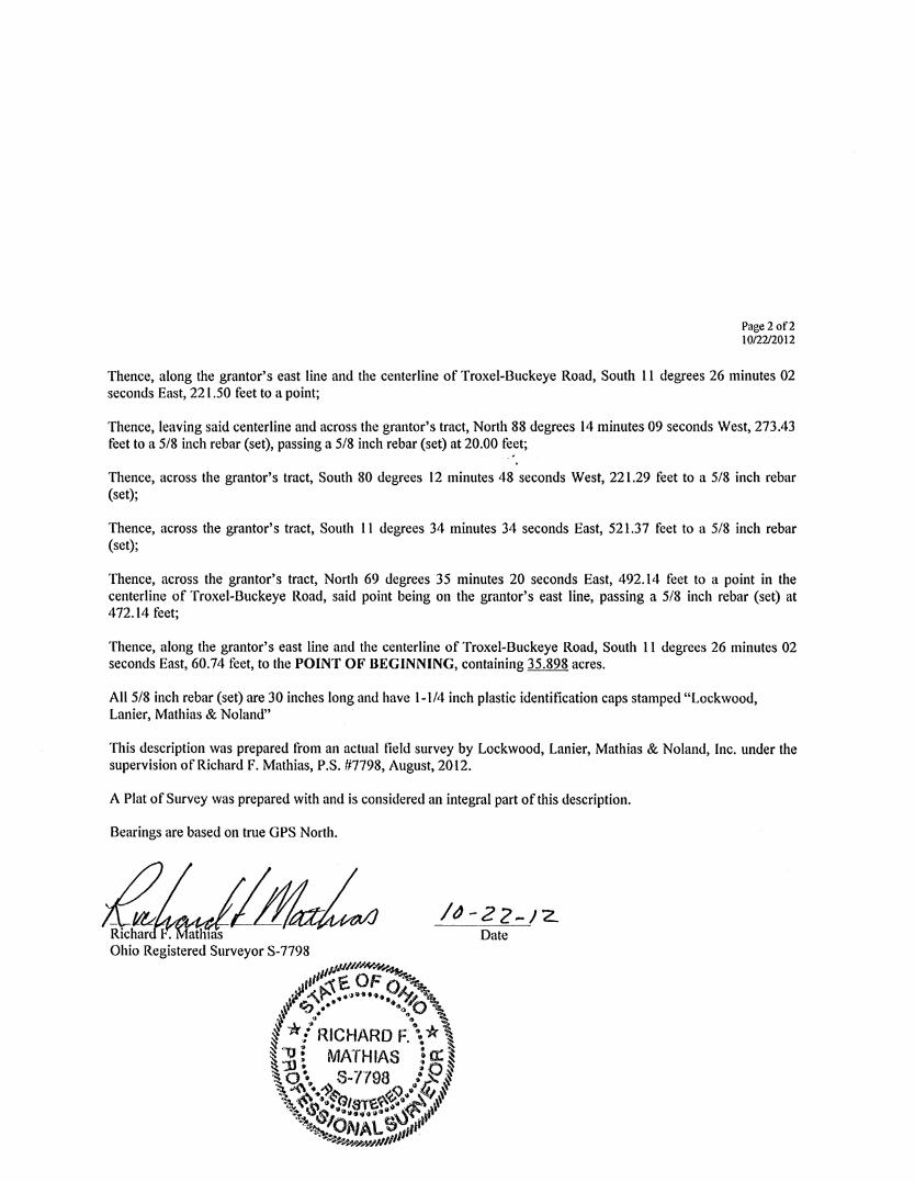
Thence, along the grantor's east line and the centerline of Troxel-Buckeye Road, South 11 degrees 26 minutes 02 seconds East, 221.50 feet to a point;
Thence, leaving said centerline and across the grantor's tract, North 88 degrees 14 minutes 09 seconds West, 273.43 feet to a 5/8 inch rebar (set), passing a 5/8 inch rebar (set) at 20.00 feet;
Thence, across the grantor's tract, South 80 degrees 12 minutes 48 seconds West, 221.29 feet to a 5/8 inch rebar (set);
Thence, across the grantor's tract, South 11 degrees 34 minutes 34 seconds East, 521.37 feet to a 5/8 inch rebar (set);
Thence, across the grantor's tract, North 69 degrees 35 minutes 20 seconds East, 492.14 feet to a point in the centerline of Troxel-Buckeye Road, said point being on the grantor's east line, passing a 5/8 inch rebar (set) at 472.14 feet;
Thence, along the grantor's east line and the centerline of Troxel-Buckeye Road, South 11 degrees 26 minutes 02 seconds East, 60.74 feet, to the POINT OF BEGINNING, containing 35.898 acres.
All 5/8 inch rebar (set) are 30 inches long and have 1-1/4 inch plastic identification caps stamped "Lockwood, Lanier, Mathias & Noland"
This description was prepared from an actual field survey by Lockwood, Lanier, Mathias & Noland, Inc. under the supervision of Richard F. Mathias, P.S. #7798, August, 2012.
A Plat of Survey was prepared with and is considered an integral part of this description.
Bearings are based on true GPS North.
/tJ-22-12.. Date
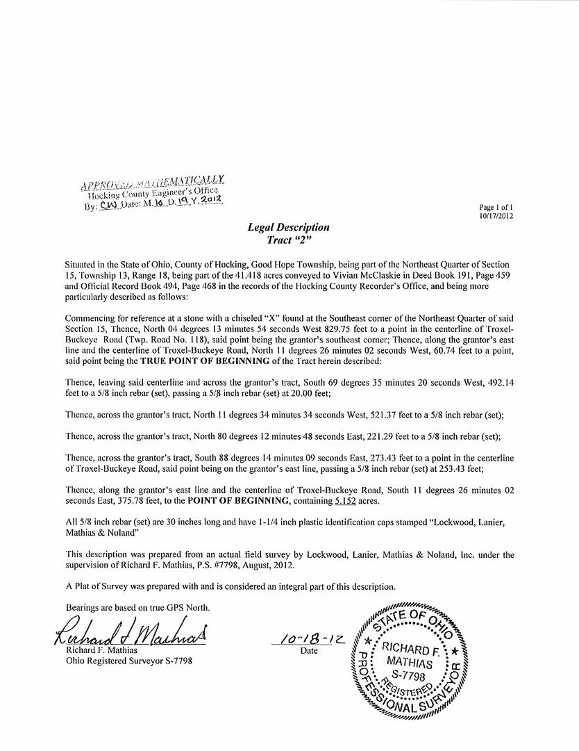
Legal Description Tract "2"
Page 1 of I 10/17/2012
Situated in the State of Ohio, County of Hocking, Good Hope Township, being part of the Northeast Quarter of Section 15, Township 13, Range 18, being part of the 41.418 acres conveyed to Vivian McClaskie in Deed Book 191, Page 459 and Official Record Book 494, Page 468 in the records of the Hocking County Recorder's Office, and being more particularly described as follows:
Commencing for reference at a stone with a chiseled "X" found at the Southeast corner of the Northeast Quarter of said Section 15, Thence, North 04 degrees 13 minutes 54 seconds West 829.75 feet to a point in the centerline ofTroxelBuckeye Road (Twp. Road No. 118), said point being the grantor's southeast corner; Thence, along the grantor's east line and the centerline of Troxel-Buckeye Road, North 11 degrees 26 minutes 02 seconds West, 60.74 feet to a point, said point being the TRUE POINT OF BEGINNING of the Tract herein described:
Thence, leaving said centerline and across the grantor's tract, South 69 degrees 35 minutes 20 seconds West, 492.14 feet to a 5/8 inch rebar (set), passing a 5/.8 inch rebar (set) at 20.00 feet;
Thence, across the grantor's tract, North 11 degrees 34 minutes 34 seconds West, 521.37 feet to a 5/8 inch rebar (set);
Thence, across the grantor's tract, North 80 degrees 12 minutes 48 seconds East, 221.29 feet to a 5/8 inch rebar (set);
Thence, across the grantor's tract, South 88 degrees 14 minutes 09 seconds East, 273.43 feet to a point in the centerline of Troxel-Buckeye Road, said point being on the grantor's east line, passing a 5/8 inch rebar (set) at 253.43 feet;
Thence, along the grantor's east line and the centerline of Troxel-Buckeye Road, South 11 degrees 26 minutes 02 seconds East, 375.78 feet, to the POINT OF BEGINNING, containing 5.152 acres.
All 5/8 inch rebar (set) are 30 inches long and have 1-1/4 inch plastic identification caps stamped "Lockwood, Lanier, Mathias & Noland"
This description was prepared from an actual field survey by Lockwood, Lanier, Mathias & Noland, Inc. under the supervision of Richard F. Mathias, P.S. #7798, August, 2012.
A Plat of Survey was prepared with and is considered an integral part of this description.
Bearings are based on true GPS North.
~!fl~ Richard F. Mathias Ohio Registered Surveyor S-7798
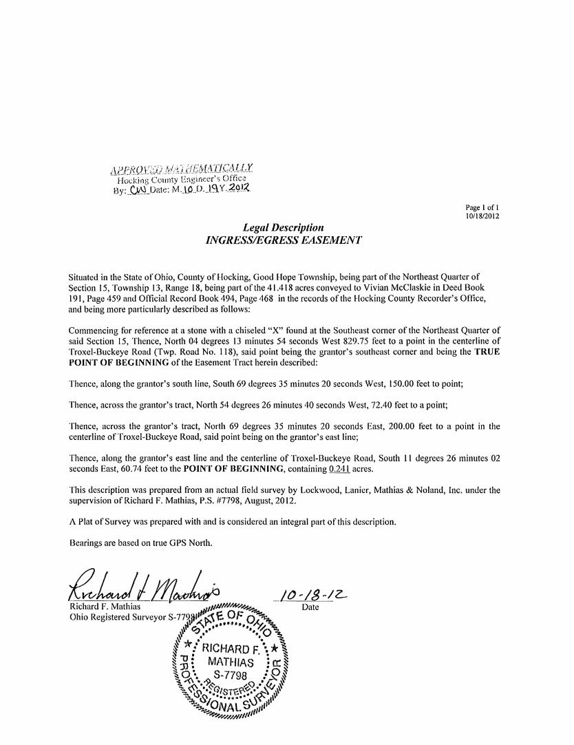
Legal Description INGRESS/EGRESS EASEMENT
Page I of I 10/18/2012
Situated in the State of Ohio, County of Hocking, Good Hope Township, being part of the Northeast Quarter of Section 15, Township 13, Range 18, being part of the 41.418 acres conveyed to Vivian McClaskie in Deed Book I 91, Page 459 and Official Record Book 494, Page 468 in the records of the Hocking County Recorder's Office, and being more particularly described as follows:
Commencing for reference at a stone with a chiseled "X" found at the Southeast comer of the Northeast Quarter of said Section 15, Thence, North 04 degrees 13 minutes 54 seconds West 829.75 feet to a point in the centerline of Troxel-Buckeye Road (Twp. Road No. I 18), said point being the grantor's southeast comer and being the TRUE POINT OF BEGINNING of the Easement Tract herein described:
Thence, along the grantor's south line, South 69 degrees 35 minutes 20 seconds West, 150.00 feet to point;
Thence, across the grantor's tract, North 54 degrees 26 minutes 40 seconds West, 72.40 feet to a point;
Thence, across the grantor's tract, North 69 degrees 35 minutes 20 seconds East, 200.00 feet to a point in the centerline of Troxel-Buckeye Road, said point being on the grantor's east line;
Thence, along the grantor's east line and the centerline of Troxel-Buckeye Road, South l l degrees 26 minutes 02 seconds East, 60.74 feet to the POINT OF BEGINNING, containing 0.241 acres.
This description was prepared from an actual field survey by Lockwood, Lanier, Mathias & Noland, Inc. under the supervision of Richard F. Mathias, P.S. #7798, August, 2012.
A Plat of Survey was prepared with and is considered an integral part of this description.
Bearings are based on true GPS North.
I I /}' I /I
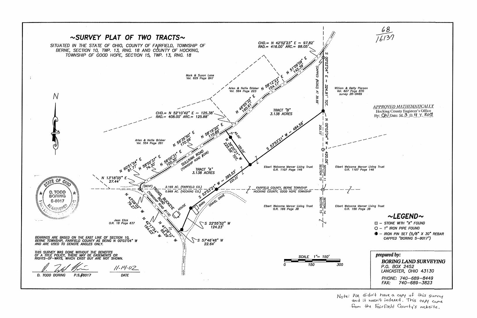
I, I 'YSURV£Y PLAT OF TWO TRACTS"'
SITUATED IN THE STA TE OF OHIO, COUNTY OF FAJRFIELD, TOWNSHIP OF BERNE, SECTION 10, TWP. 13, RNG. 18 AND COUNTY OF HOCKING,
TOWNSHIP OF GOOD HOPE, SECTION 15, TWP. 13, RNG. 18
CHO.= N 42'52'23• £,... 97.82' I// RAD.= 416.00' ARC.= 98.05'~ I/
// // Cl)
/ "'\ "' ~ /:·/ ~
N
Mark & Susan Lane Vol. 629 Page 847
/ \ •()~. ,// 7 0 / \ ,...o~ '!>~ / ,/ 'Q <1.
/ \ f)' Dc'J.·/ / jj ~ / \ \\ \/~/ ::0 •
/ t // l'.l l'T1 / ,n"!f \ ,,..<_,' 'll. • / 'J."'. / ~ El •
/ ~\ \1/!-/ fl ~ / Arlen & Neille Brisker ~ ~ \f}c,°#' "V "' William & Betty Pierson
/ Vol. 564 Page 223 _,-: ,-' ~ '!'- Vol. 627 Page 870 / ,_ .~/ ~ survey 28-9469
-<' "' ~ /7'" ~ -,...- - ' . ·~'}, ,··"·./' ~ a -- - - '\ '!J~"'~'#/ ;-i
_, '\ DI ~()· / / TRACT "8" CHD.= N 52'10'42" £,... 125.JB'~'\" \\ ~/}' J.138 ACRE:S RAD.= 408.00' ARC.= 125.88' ,, / ;/ I ':z
\. ,'',/ , ~ I t!. ...... / ·Jl} ~ 00
O"' ~ ,/ ,/ _a.De· g'V ~ ,,,, _,- ..,v . I cl
ft /6131
Arlen & Neme Brisker Vol. 554 Page 261
"' t '-''O' o:O~<-- -,..s-ir,- • -t\ '"' ~I ~ .... ~'J~ ~ \~-::·/ .A ·q,. ,n\ I ~ - - - -~ jJ ~~ . /~ -,, :!> "' -
.. \ fl ,10·~ ,,,z;-- ~-'&. :tj'J I ::e - - - -\" /•/ ~ 12 'J ·---~/ ·~'b. I?~ ? Qr.
, t /?'Fo~ ~'I ~·,:> O". I ~ I \ ,/ :/ ~ ~'/,q ,,)}_,.I'.. '"
t!. "'"' t "0"?>~ ,..;;!-~-~ ~ .. o o;.~ I P I too t'!.JI ~u "J"~-:\\ ~or- • ~
... ·~~ ,,~0 .... 0. ~ e;,99~!>_,-s-J ~i·''? Vl1V)· ..!'~ '11 ~v 6r J - - "# Elbert Welcome Mercer living Trust r:ri r:ri Elbert Welcome Mercer Living Trust
~ fJVro'· ~ 1 ·~--<>' ~o TRACT "A" • O.R. 1107 Page 146 21~ O.R. 1107 Page 146 ,/ ,/ J.138 ACRES ~~"), ~ ~
'·, N 1J'18'05• £ / ~-- "J~ '!.'].. ... 1 ...
'' 27.44' ~~,.,. ::---- , ~ ~ ,,,i'J· ' 0-fl~ ___ ~ __ -::..-::.:_--::__ /(BENT)>.. _ _ 2~9~C:.Jf~~'?_E0.) _ •'/,,\ . ____ -I- _FAIRF]gQ__S:OUNTY, !!f.RN£ TOWNSHIP _ _ • ___ -t-_
-----------,, \ ~ ~~ 0.969 AC. (HOCKING co.) '!J':J<fj ,-:::::;:-, HOCKING COUNTY, GOOD HOP£ TOWNSHIP .,,, iJ''' 04 ~ ':> / <~ -, ', ~ ',~~~ ~ ~ ~ /'/fl)~ --~>-, KllCll ....\a ',\ ',~ ~ ~ ~ /~'~" ',<, 21~
IS> \P. ' ', ~ ~ :of; " ~ '/~ 0 ::I .'lil Q..., ',,:', q,,~ (<'}_ 'i:le:,~ ~ /~' G Elbert Welcome Mercer LMng Trust '=I~ ~ • ..-... '~', v ~~ y.O , ' O.R. 166 Page JB
' '~ I I ',.',~ 1/ ~ 111',,',~ () /,,, ~I~ """ ',,',, ,// ~ Jean Elick ,
O.R. 18 Page 637 ~ ,Z, '-.; ', ' S 22'55'52" W I .Jil .. ' ' ,, ' ... ~,~ 'JI',. ' ', ,, 124.23
JI' ~~ "'• >' ' 1' I
BEARINGS ARE BASED ON THE £AST LINE OF SECT10N 10, BERNE TOWNSHIP, FAIRFIEW COUNTY AS BEING N OO'OJ'04" W AND ARE USED TO DENOTE ANGLES ONLY.
THIS SURVEY WAS DONE WITHOUT THE BENEFITS
·o'"',,..,, ~~d'. \,'' _J/ \J'. •.a ,, \ , I
~ U>.Vl... \ \ . ' ~ '-'/
\\\ I I I I I I I I ,.,
s 57'46'48" w 22.64'
SCALE 1 "= 150'
Elbert Welcome Mercer Living Trust O.R. 166 Page JB
"'L£G£ND"' G - STONE WITH "X" FOUND 0 - 1" IRON PIPE FOUND
• - IRON PIN SET (5/8" X JO" REBAR CAPPED "BORING 5-8017")
prepared by: OF A Tm.£ POLICY, THERE MAY BE £ASEMENTS OR RIGHTS-OF-WAYS, WHICH EXIST BUT ARE NOT SHOWN. 111 I I - - - BORING LAND SURVEYING
P.O. BOX 2452 LML~ D. TODD BORING P.S./18017 DATE
I I I I I I ... !1! I I
' '
- - -0 150 JOO
LANCASTER, OHIO 4J 1 JO
PHONE: 740-689-8449 FAX: 740-689-3823
No+e: £1\J~ di' Jr,·+ ho.vl ex cop-( oP. +his su""~'( Q.I'\ d i + Nl.\S¥\ 1-\. j,, de.x.vi . -rhts 011 f'( <:.a..r'-\.J..
-\:'rott-' -It'.( 'Fc;.i fti'e..ld Cc~vd,1's web:sH-e.
BORING lAND SURVEYING P.O. Box 2452
Lancaster, Ohio 43130
Phone: 740-689-8449 Fax: 740-689-3823
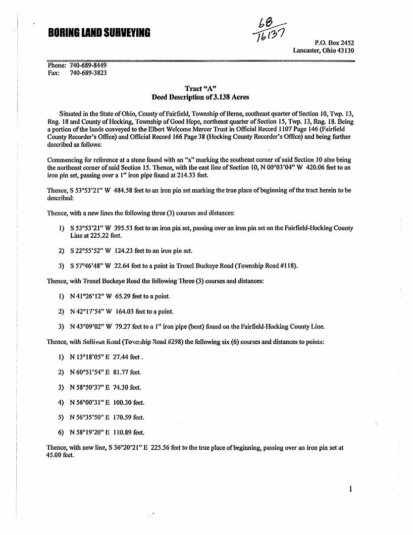
Trad"A" Deed Description of3.138 Acres
Situated in the State of Ohio, County ofFairfield, Township of Berne, southeast quarter of Section 10, Twp. 13, Rng. 18 and County of Hocking, Township of Good Hope, northeast quarter of Section 15, Twp. 13, Rng. 18. Being a portion of the lands conveyed to the Elbert Welcome Mercer Trust in Official Record 1107 Page 146 (Fairfield County Recorder's Office) and Official Record 166 Page 38 (Hocking County Recorder's Office) and being further described as follows:
Commencing for reference at a stone found with an "x" marking the southeast corner of said Section 10 also being the northeast corner of said Section 15. Thence, with the east line of Section 10, N 00°03'04" W 420.06 feet to an iron pin set, passing over al" iron pipe found at 214.33 feet.
Thence, S 53°53'21" W 484.58 feet to an iron pin set marking the true place of beginning of the tract herein to be described:
· Thence, with a new lines the following three (3) courses and distances:
l) S 53°53 '21" W 395.53 feet to an iron piri set, passing over an iron pin set on the Fairfield-Hocking County Line at 225.22 feet.
2) S 22°55'52" W 124.23 feet to an iron pin set.
3) S 57°46'48" W 22.64 feet to a point in Troxel Buckeye Road (Township Road #118).
Thence, with Troxel Buckeye Road the following Three (3) courses and distances:
1) N 41°26'12" W 65.29 feet to a point.
2) N 42°17'54" W 164.03 feet to a point.
3) N 43°09'02" W 79.27 feet to a 1" iron pipe (bent) found on the Fairfield-Hocking County Line.
Thence, with Sullivan Rvad (Towmhip Road #298) the following six (6) courses and distances to poinis:
1) N 13°18'05" E 27.44 feet.
2) N 60°51 '54" E 81.77 feet.
3) N 58°50'37" E 74.30 feet.
4) N 56°00'31" E 100.30 feet.
5) N 56°35'50" E 170.59 feet.
6) N 58°19'20" E 110.89 feet.
Thence, with new line, S 36°20'21" E 225.56 feet to the true place of beginning, passing over an iron pin set at 45.00 feet. .
1
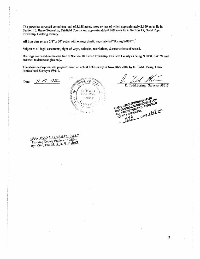
The parcel as surveyed contains a total of3.138 acres, more or less of which approximately 2.169 acres lie in Section 10, Berne Township, Fairfield County and approximately 0.969 acres lie in Section 15, Good Hope Township, Hocking County.
All iron pins set are 5/8" x 30" rebar with orange plastic caps labeled "Boring S-8017".'
Subject to all legal easements, right-of-ways, setbacks, restrktions, & reservations of record.
Bearings are based on the east line of Section 10, Berne Township, Fairfield County as being N 00°03'04" Wand are used to denote angles only.
The above description was prepared from an actual field survey in November 2002 by D. Todd Boring, Ohio Professional Surveyor #8017.
Date: //-/~(-OZ-D. Todd Boring, Surveyor #8017
2
tt BORING IAND SURVEYING ---/tf?J1
P.O. Box 2452 Lancaster, Ohio 43130
Phone: 740-689-8449 Fax: 740-689-3823
AfeRQYJW}:/1:,'fJfE,1J~ll'lG.~~\£J~X " ,, Hocking County Engln1~er's Offic~
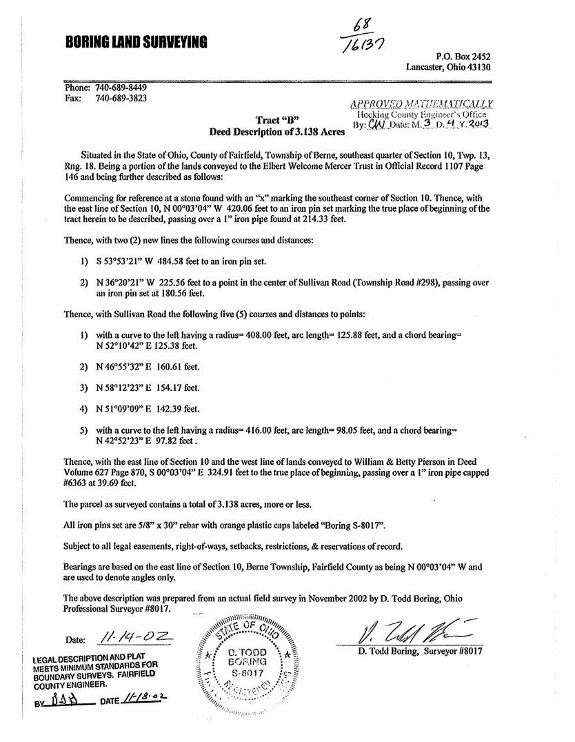
D~~..1 D ~~ct Bf3138 A By:_~_.Oate: M .. 3-,0.!J .. Y.~O.'~-\X\l escnpt1on o • cres
Situated in the State of Ohio, County ofFairfield, Township of Berne, southeast quarter of Section 10, Twp. 13, Rng. 18. Being a portion of the lands conveyed to the Elbert Welcome Mercer Trust in Official Record 1107 Page 146 and being further described as follows:
Commencing for reference at a stone found with an ''x" marking the southeast comer of Section 10. Thence, with the east line of Section 10, N 00°03'04" W 420.06 feet to an iron pin set marking the true place of beginning of the tract herein to be described, passing over a 1" iron pipe found at 214.33 feet.
Thence, with two (2) new lines the following courses and distances:
1) S 53°53'21" W 484.58 feet to an iron pin set.
2) N 36°20'21" W 225.56 feet to a point in the center of Sullivan Road (Township Road #298), passing over an iron pin set at 180.56 feet.
Thence, with Sullivan Road the following five (5) courses and distances to points:
1) with a curve to the left having a radius= 408.00 feet, arc length= 125.88 feet, and a chord bearing= N 52°10'42" E 125.38 feet.
2) N 46°55'32" E 160.61 feet.
3) N 58°12'23" E 154.17 feet.
4) N 51°09'09" E 142.39 feet.
5) with a curve to the left having a radius= 416.00 feet, arc length== 98.05 feet, and a chord bearing= N 42°52'23" E 97.82 feet.
Thence, with the east line of Section 10 and the west line oflands conveyed to William & Betty Pierson in Deed Volume 627 Page 870, S 00°03'04" E 324.91 feet to the true place ofbeginni.og, passing over a 1" iron pipe capped #6363 at 39.69 feet.
The parcel as surveyed contains a total of3.138 acres, more or less.
All iron pins set are 5/8" x 30" rebar with orange plastic caps labeled "Boring S-8017".
Subject to all legal easements, right-of-ways, setbacks, restrictions, & re5ervations of record.
Bearings are based on the east line of Section 10, Berne Township, Fairfield County as being N 00°03'04" Wand are used to denote angles only.
The above description was prepared from an actual field survey in November 2002 by D. Todd Boring, Ohio Professional Surveyor #8017.
Date: //- /q - t!) z._
LEGAL DESCRIPTION AND PLAT MEETS MINIMUM STANDARDS FOR BOUNDARY SURVEYS. FAlRFIELD COUNTY ENGINEER.
BY. 6~ Si DATE tf-f 8' 4 2-
D. Todd Boring, Surveyor #8017
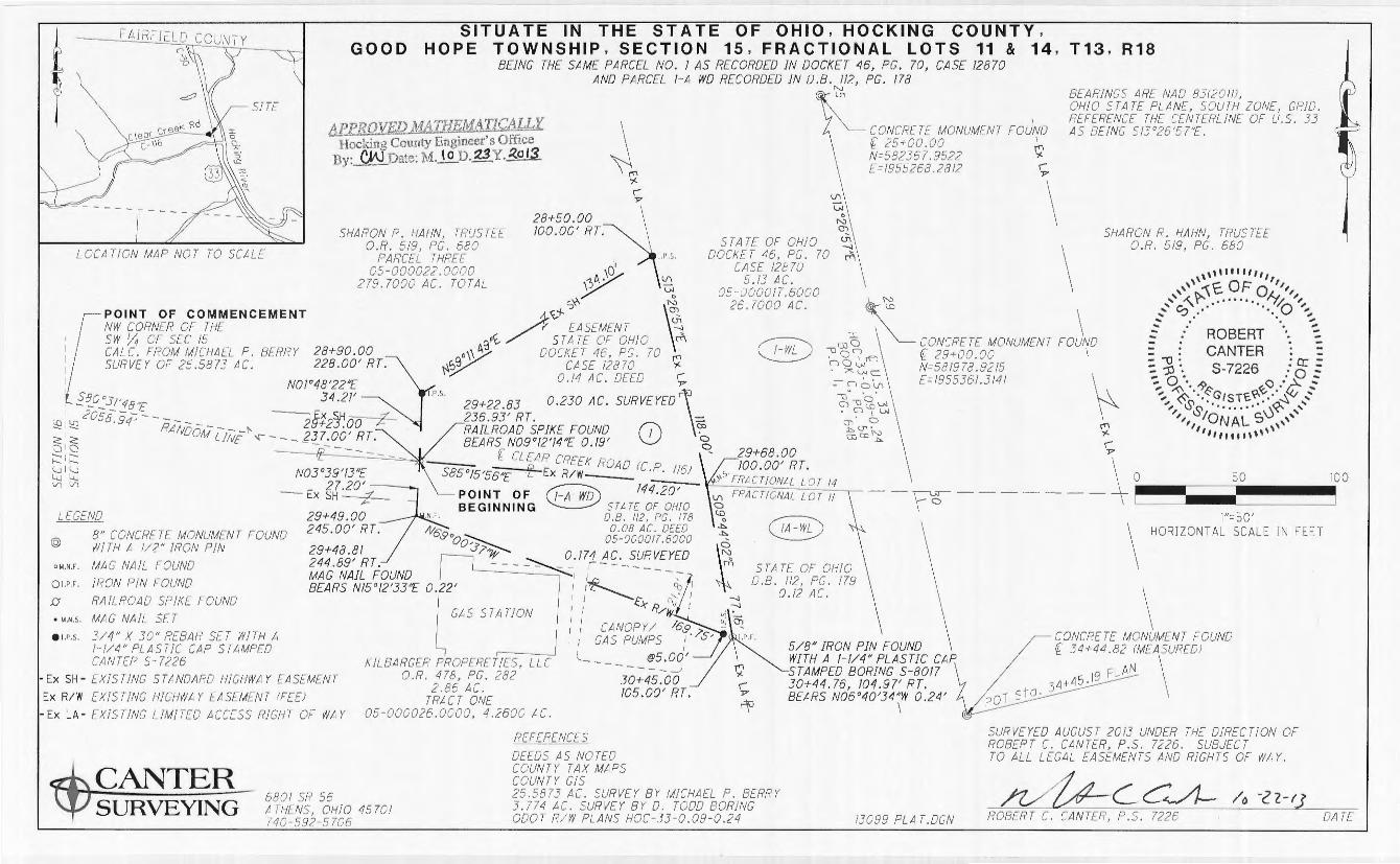
GOOD SITUATE IN THE ST ATE OF OHIO, HOCKING COUNTY ,
HOPE TOWNSHIP, SECTION 15 , FRACTIONAL LOTS 11 & 14 , T13 , R18 BEING THE SAME PARCEL NO . I AS RECORDED IN DOCKET 46, PG. 70, CASE 12870
AND PARCEL 1-A WD RECORDED JN D.B. 112, PG. 178 l'.J ui BEARINGS AHL NAO 83f2011J,
APPROVED MATHEM!.4TICALLY Hoc!:-!n~ County Engineer's Office Dy:~Date: M.JE..D. 23Y. ~ol3
I CONCR[ IE MONUMENT FOUND f 25~00 . 00 1
N 582367.9522 r;i [ 1955268 .2812 i;.
OHIO ST A TF PL AN[, SOU TH ZONE, GRID. REFERFN[[ T/-1[ CEN7£RLINE OF U.S. 33 AS BEING S/3°26'57"£.
LOCATION MAP NOT TO SCALE
LEGEND
@
o M.N.F',
Ql.P.F.
• Y.N.S.
e 1.P.S.
8" CONCRfT[ MONUMFN T FOUND Wll !-1 A 1/2" !RON PJN MAG NAIL FOUND IRON PIN FOUND RAILROAD SPJK[ FOUND MAG NAIL SE7 3/4" X 30" REBAR SET WITH A I 1/4" Pl ASTJC CAP STAMPED CANTER S 7226
- Ex SH - EXISTING STANDARD H!GHWA Y EASEMENT Ex R/W EXISTING H!GHWA Y [ASEMENl rFEEJ - Ex LA- EX!SlJNG LIMI TED ACCESS RIGHT OF WAY
CANTER SURVEYING
6801 SR 56 ATH[NS, OHIO 45701 740-592 5706
REFERENCES DEWS AS NOTED COUNT Y TAX MAPS COUNIY GIS
STAT[ OF OHJO DOCKET 46, PG . 70
CASE 12870 5.13 AC .
05-000017. 6000 26 . 7000 AC.
25 .5873 AC. SURV[Y BY MICHAEL P . BERRY 3 . 774 AC. SURVEY BY 0. TODD BORING ODOT R/W PLANS HOC-33 0.09-0 .24
\ \ \
SHARON R. I/AHN, TRUSTEE O.R. 519, PG. 680
,,,, .... ,,,, ,, 0 ,, ,, :1\'C. F 0 ,, ,''~~ . ..... . IY,1, ,,,
.. ... ' 0 .. · · ·· .. 0 ........ ..... . ·. , .. ;
CONCRETE MONUMENT r OUNO = ROBERT . ~ - -- CANTER -f 29+00.00 I ~ ] :. S-7226 .: g ~ N=581978.9215
[ 1955361.3141 7:, ~··. '9 «.,'> .:>:. :
13099 PLA T.DGN
",, ~ ··.~G/S T'C~_.· ·~<v , .... .. , i.$''5' ..... ... \~ ,,
,, IONAL sv , .. ,, , .. ,,,,,,.,1\,,,,
SURVEYED AUGUST 2013 UNOCR TH[ DIRECTION OF ROBERT C. CAN7CR, P.S. 7226. SUBJECT TO ALL LEGAL EASEMENTS ANO RIG/17 S OF WAY.
~c c~_/o_-2_2_-f~J __ ROBERT C. CANTCR, P.S. 7226 DA TE
Exhibit A
0.174 Acres
Situate in the State of Ohio, Hocking County, Good Hope Township, Section 15, Fractional Lot 11, Tl3, Rl 8 and being the same as Parcel 1-A WO recorded in Deed Book 112, Page 178 and being more particularly described as follows:
Commencing at the northwest corner of the southwest quarter of Section 15 (calculated from a 25 .5873 acre survey by Michael P. Berry);
Thence South 80 Degrees 31 Minutes 48 Seconds East 2058.94 feet along a random line to a point in the center of Clear Creek Road (C.R. 116) at centerline station 29+23 .00, 23 7 .00 feet right where a railroad spike found bears North 09 Degrees 12 Minutes 14 Seconds East 0.19 feet, being a point on the north line of Fractional Lot 11, the south line of Fractional Lot 14, the north line of a 2.86 acre parcel conveyed to Kilbarger Properties, LLC recorded in Official Record 478, Page 282 a point on the south line of Sharon R. Hahn, Trustee recorded in Official Record 519, Page 680, the northwest corner of a 0.08 acre parcel conveyed to the State of Ohio recorded in Deed Book 112, Page 178 and the southwest corner of a 0.14 acre highway easement to the State of Ohio recorded in Hocking County Court of Common Pleas Docket 46, Page 70, Case 12870, said point being the Point of Beginning for the parcel herein described;
Thence from the Point of Beginning South 85 Degrees 15 Minutes 56 Seconds East 144.20 feet along the north line of the subject parcel 1-A WO, the centerline of Clear Creek Road (C.R. 116), the south line of Fractional Lot 14, the north line of Fractional Lot 11 and the south line of Sharon R. Hahn, Trustee recorded in Official Record 519, Page 680 to a mag nail set at the southeast corner of a highway easement conveyed to State of Ohio recorded in Hocking County Court of Common Pleas Docket 46, Page 70, Case 12870, the northeast corner of subject parcel 1-A WD and the northwest corner of a 0.12 acre parcel conveyed to the State of Ohio recorded in Deed Book 112, Page 179 at centerline station 29+68.00, 100.00 feet right;
Thence South 09 Degrees 44 Minutes 02 Seconds East 77 .16 feet along the east line of subject parcel 1-A WO the existing west limited access right of way of U.S. 33 and the west line of said 0.12 acre parcel to a point on the east line of a 2.86 acre parcel conveyed to Kilbarger Properties, LLC recorded in Official Record 478, Page 282 at centerline station 30+45.00, 105.00 feet right where a 5/8 inch iron pin found with a 1-114 inch plastic cap stamped Boring S-8017 bears North 06 Degrees 40 Minutes 34 Seconds West 0.24 feet;
Thence North 69 Degrees 00 Minutes 37 Seconds West 169.75 feet along the south line of subject parcel 1-A WO being the south right of way of Clear Creek Road and a northerly line of said 2.86 acre parcel passing an iron pin set at 5.00 feet to a point at centerline station 29+49.00, 245.00 feet right where a mag nail found bears North 15 Degrees 12 Minutes 33 Seconds East 0.22 feet;
Thence North 03 Degrees 39 Minutes 13 Seconds East 27.20 feet along the west line of subject parcel 1-A WO and a northerly line of said 2.86 acre parcel to the Point of Beginning.
The above described contains 0.174 acres more or less and in contained in Auditor's Permanent Parcel Number 05-000017.6000 which presently shows 26.7000 acres.
Subject to all legal easements and rights of way.
All iron pins set are% inch diameter by 30 inch long rebar with a 1-1/4 inch plastic cap stamped Canter S-7226.
Prior Instrument Reference: Deed Book 112, Page 178 of the Hocking County Recorder's office.
This description was prepared under the direction and supervision of Robert C. Canter, Registered Surveyor No. 7226 and is based on a field survey made by Canter Surveying/OPS Services, Inc. completed September 2013.
All stations and offsets are based on the ODOT right of way plans HOC-33-0.09-0.24.
Bearings are NAO 83(2011 ), Ohio State Plane, South Zone Grid. Based on OPS observations. Reference the centerline of U.S. 33 being South 13 Degrees 26 Minutes 57 Seconds East.
/2.--</rL~ c~-~ Robert C. Canter, P.S. 7226
\\\''""'''''' ,,'' ~t:. OF 01.,'1,, .... ' -<..'?- ......... ·r;,o''
...... ' 0 .. ·· ·.. ...,,,, .... . . ,, ~ ROBERT ~ : . CANTER .· er ---- -\J · "'2' :: -;J •. s-72 6 : 0 :: ":. 0 ·. '9 «.,<> •• >- ::
-:-,.. ~"·.~GtsT'G'(X,.·· ..... ~ .., ..... ,,.. '0's ......... )«"- , ... '1, IONAL S' ,,' '1, ,,,
''''"'"''
;a/z <-lo r I
Date
A PP/?!JVED }/IA'fHl~'t'i,!Ail(,~JflX -·fi;~;~.i~1~"(~;;~;Zty.l:f;t;;·r;;;e;'s Office Hy:_C'!!_ __ Dl1tc: M.10.JJ.23.Y .. ~.Q~.
Exhibit A
0.230 Acres
Situate in the State of Ohio, Hocking County, Good Hope Township, Section 15, Fractional Lot 14, Tl3, R 18 and being the same as Parcel No. 1 recorded in Hocking County Court of Common Pleas Docket 46, Page 70, Case 12870 and being more particularly described as follows:
Commencing at the northwest corner of the southwest quarter of Section 15 (calculated from a 25.5873 acre survey by Michael P. Berry);
Thence South 80 Degrees 31 Minutes 48 Seconds East 2058.94 feet along a random line to a point in the center of Clear Creek Road (C.R. 116) at centerline station 29+23 .00, 23 7 .00 feet right where a railroad spike found bears North 09 Degrees 12 Minutes 14 Seconds East 0.19 feet, being a point on the north line of Fractional Lot 11, the south line of Fractional Lot 14, the north line of a 2.86 acre parcel conveyed to Kilbarger Properties, LLC recorded in Official Record 4 78, Page 282 a point on the south line of Sharon R. Hahn, Trustee recorded in Official Record 519, Page 680, the northwest corner of a 0.08 acre parcel conveyed to the State of Ohio recorded in Deed Book 112, Page 178 and the southwest corner of a 0.14 acre highway easement to the State of Ohio recorded in Hocking County Court of Common Pleas Docket 46, Page 70, Case 12870, said point being the Point of Beginning for the parcel herein described;
Thence from the Point of Beginning North 01 Degrees 48 Minutes 22 Seconds East 34.21 feet along the west line of subject easement to an iron pin set at centerline station 28+90.00, 228.00 feet right;
Thence North 59 Degrees 11 Minutes 49 Seconds East 134.10 feet along the north line of subject easement to an iron pin set on the existing west limited access right of way of U.S. 33 being the west line of a 5 .13 acre parcel conveyed to the State of Ohio recorded in Hocking County Court of Common Pleas Docket 46, Page 70, Case 12870 at centerline station 28+50.00, 100.00 feet right;
Thence South 13 Degrees 26 Minutes 57 Seconds East 118.00 feet along the east line of subject easement, existing west limited access right of way of U.S. 33 and the west line of said 5.13 acre parcel to a mag nail set at the southeast corner of subject easement, the northeast corner of a 0.08 acre parcel conveyed to the State of Ohio recorded in Deed Book 112, Page 178 and the northwest corner of a 0.12 acre parcel conveyed to the State of Ohio recorded in Deed Book 112, Page 179, the center of Clear Creek Road (C.R. 116), the north line of Fractional Lot 11 and the south line of Fractional Lot 14 at centerline station 29+68.00, 100.00 feet right;
Thence North 85 Degrees 15 Minutes 56 Seconds West 144.20 feet along the south line of subject parcel, the center of Clear Creek Road (C.R. 116), the south line of Fractional Lot 14, the north line of Fractional Lot l l and the north line of said 0.08 acre parcel to the Point of Beginning.
The above described contains 0.230 acres more or less and is contained in Auditor's Permanent Parcel Number 05-000022.0000 which presently shows 279.7000 acres.
Subject to all legal easements and rights of way.
All iron pins set are% inch diameter by 30 inch long rebar with a 1-114 inch plastic cap stamped Canter S-7226.
Prior Instrument Reference: Docket 46, Page 70, Case 12870 of the Hocking County Court of Common Pleas.
This description was prepared under the direction and supervision of Robert C. Canter, Registered Surveyor No. 7226 and is based on a field survey made by Canter Surveying/GPS Services, Inc. completed September 2013.
All stations and offsets are based on the ODOT right of way plans HOC-33-0.09-0.24.
Bearings are NAO 83(20 l l ), Ohio State Plane, South Zone Grid. Based on GPS observations. Reference the centerline of U.S. 33 being South 13 Degrees 26 Minutes 57 Seconds East.
/2 /rL" c2L__ Robert C. Canter, P.S. 7226
,,,,,.,,,,,, \ \ 0 ,,
,,, \>-'\E. F O 111
,<'' 0'\ ............. ~/'.o'' .. .. ' . . ~
:: HOBEfH ·. ~ : .0 : CANTER _ -; J) ·. c. 7226 : a: :: -:.o·. "-· :o::
-;. ~ "-9<$' <'.<) .. ~ .. "' ~ ', (~/ST~\\~·· I~/,' ..... , ~s& ............ ~\ , ... ..
,,, iorvAt s0 ,,, ,,, . ,, ,,,,,,.,,,,,
/of <-L-/13 Date
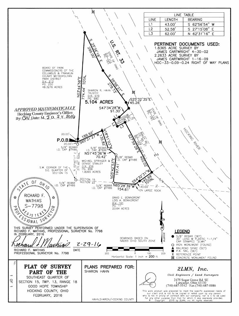
\ \ ~ \ \
\
LINE TABLE LINE LENGTH BEARING
\ L3 62.00' N 62'31'16" E
\ '----==--~-=-=---------.!-----'-'---=-=~--=----------..
BOARD OF PARK COMMISSIONERS OF THE COLUMBUS & FRANKLIN COUNll' METROPOLITAN PARK DISTRICT D.V. 213 PG. 250 48.3276 ACRES
c. "'I'
< y..01.,\;
/~ \...~ ' -t,. 7.. .,,>
'099 I~.,,,. o:>, \;~\ 7.. ~ ~-......... s~c ·o:> o
t-J. (JI~ 5/8" REBAR 5/8" REBAR z
l.D. CAP #74861 1.D. CAP #7486 w ~ N51"45'36"W
\
\
:-..12 70.42' 5/8" REBAR ;;; 1· MICHAEL SPRINGER & •W ID. CAP #7486 ~ ~ DENISE STANLEY {ri :.,_
s.w. CORNER OF THE 0 I~ ~t· 625566 "' "': S.E. QUARTER OF\[-IN 1 8.365 ACRES :t r-..
SECTION 15 · lO Ol 0
1/////1//////;;_,. SECTION 15 ;z 111 OF ........ - -111 ~ Q ........ -::.. 5/8" REBAR SECTION 22 - - -·'-r.,~~'!"'-_.;:;:~
111 ~\ ••••••• If I ~ l.D. CAP #7486 5/8" REBAR 111 r~ .••' 0
'••,, 0 c:::_ 1.D. CAP #7486 ~ ~J • • -
I* / 0
RICHARD F. \~ * \ ~ : MATHIAS ! ~ ~ . . ~
~ ~ \ s-7798 : 0:: ~ --~·,,., ·a~ ~ 0 •,;r(' ~<::J/ ~ \~ ~ "'/··.q IS 1 t ~/ ~~ 111 ~ S's ......... ~~ i''1
-::.......... ION Al S 111 11 -............ ,,.,,,,,,/. 'L/_////11
THIS SURvW"f>ERFORMED UNDER THE SUPERVISION OF
DAVID E. BONNORONT LOIS A. BONNORONT D.V. 161 PG. 11 23.64 ACRES
\ PERTINENT DOCUMENTS USED: 1.8365 ACRE SURVEY BY
JAMES CARTWRIGHT 4-30-02 2.2633 ACRE SURVEY BY
\
\
JAMES CARTWRIGHT 1-16-09 OC-33-0.09-0.24 RIGHT OF WAY PLANS
\
\ \
\ \
\ \
LEGEND 11D!tkL su•:~o;;·_ ;::• BEARINGS BASED ON NAD83 OHIO SOUTH ZONE
• 5/8" REBAR (SET) 30" LONG W PLASTIC 1-1/4" CAP STAMPED "2LMN"
0 "Tl
RICHARD F. MATHIAS DATE PROFESSIONAL SURVEYOR No. 7798
z 0
PLAT OF SURVEY PART OF THE
SOUTHEAST QUARTER OF SECTION 15, TWP. 13, RANGE 18
GOOD HOPE TOWNSHIP HOCKING COUNTY, OHIO
FEBRUARY, 2016
200 0 100 200
0 IRON MONUMENT (FOUND) A RAILROAD SPIKE (SET) • P.K. NAIL (SET) X REFERENCE POINT
Jg{ CONCRETE MONUMENT FOUND Horizontol Scale: 1 inch = 200 ft.
PLANS PREPARED FOR: SHARON HAHN
HAHN.SHARON/HOCKING COUNll'
2LMN, Inc. Civil Engineers / Land Surveyors
2475 Sugar Grove Rd. SE Lancaster, Ohio 43130
(740) 687-5542 · Fax (740) 687-0086
This work product was prepared to meet the specific expressed needs of our client and is not to be copied or relied upon by any person
who is not in privity of contract with our company, nor is it ta be used for any other purpose than that for which it was expressly provided.
© Copyright 2015 by 2LMN, Inc. All rights reserved.
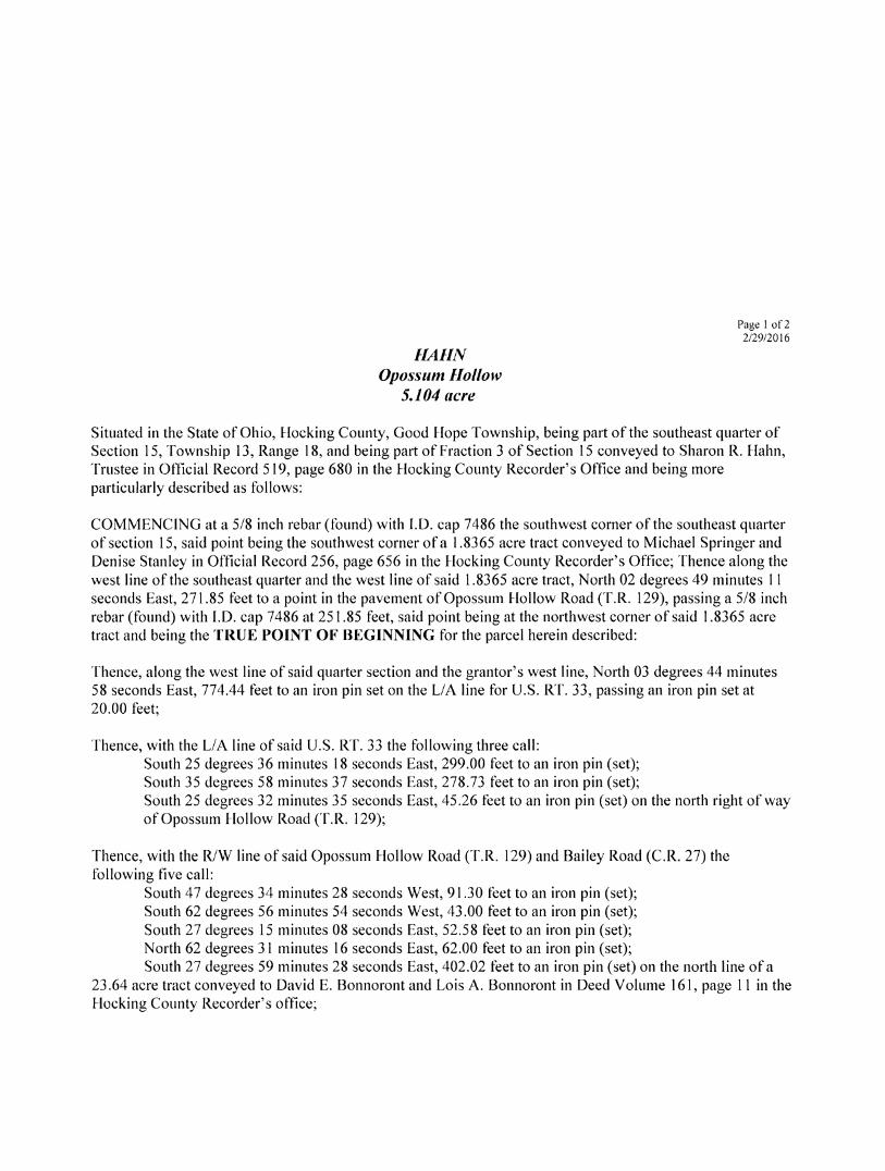
HAHN Opossum Hollow
5.104 acre
Page I of2 212912016
Situated in the State of Ohio, Hocking County, Good Hope Township, being part of the southeast quarter of Section 15, Township 13, Range 18, and being part of Fraction 3 of Section 15 conveyed to Sharon R. Hahn, Trustee in Official Record 519, page 680 in the Hocking County Recorder's Office and being more particularly described as follows:
COMMENCING at a 5/8 inch rebar (found) with I.D. cap 7486 the southwest corner of the southeast quarter of section 15, said point being the southwest corner of a 1.8365 acre tract conveyed to Michael Springer and Denise Stanley in Official Record 256, page 656 in the Hocking County Recorder's Office; Thence along the west line of the southeast quarter and the west line of said 1.8365 acre tract, North 02 degrees 49 minutes 11 seconds East, 271.85 feet to a point in the pavement of Opossum Hollow Road (T.R. 129), passing a 5/8 inch rebar (found) with I.D. cap 7486 at 251.85 feet, said point being at the northwest corner of said 1.8365 acre tract and being the TRUE POINT OF BEGINNING for the parcel herein described:
Thence, along the west line of said quarter section and the grantor's west line, North 03 degrees 44 minutes 58 seconds East, 774.44 feet to an iron pin set on the LIA line for U.S. RT. 33, passing an iron pin set at 20.00 feet;
Thence, with the LIA line of said U.S. RT. 33 the following three call: South 25 degrees 36 minutes 18 seconds East, 299.00 feet to an iron pin (set); South 35 degrees 58 minutes 37 seconds East, 278.73 feet to an iron pin (set); South 25 degrees 32 minutes 35 seconds East, 45.26 feet to an iron pin (set) on the north right of way of Opossum Hollow Road (T.R. 129);
Thence, with the R/W line of said Opossum Hollow Road CLR. 129) and Bailey Road (C.R. 27) the following five call:
South 4 7 degrees 34 minutes 28 seconds West, 91.30 feet to an iron pin (set); South 62 degrees 56 minutes 54 seconds West, 43.00 feet to an iron pin (set); South 27 degrees 15 minutes 08 seconds East, 52.58 feet to an iron pin (set); North 62 degrees 31 minutes 16 seconds East, 62.00 feet to an iron pin (set); South 27 degrees 59 minutes 28 seconds East, 402.02 feet to an iron pin (set) on the north line of a
23 .64 acre tract conveyed to David E. Bonnoront and Lois A. Bonnoront in Deed Volume 161, page 11 in the Hocking County Recorder's office;
Legal Description
Page 2 of2 2/29/2016
Thence, leaving the R/W line of Bailey Road (C.R. 27) and along the north line of said 23 .64 acre tract, South 54 degrees 32 minutes 31 seconds West, 145.69 feet to a point on a large rock outcropping, passing an iron pin (set) at 105.69 feet, said point being on the south line of said Section 15;
Thence, along the south line of said Section 15 and the grantor's south line, North 85 degrees 28 minutes 39 seconds West, 154.61 feet to a 5/8 inch rebar (found) with l.D. cap 7486 marking the southeast corner of said 1.8365 acre tract;
Thence, along the east line of said 1.8365 acre tract, North 05 degrees 42 minutes 53 seconds East, 197.41 feet to a 5/8 inch rebar (found) with l.D. cap 7486;
Thence, along the east line of said 1.8365 acre tract, North 51 degrees 45 minutes 36 seconds West, 70.42 feet to a 5/8 inch rebar (found) with l.D. cap 7486;
Thence, along the east line of said 1.8365 acre tract, North 18 degrees 51 minutes 03 seconds West, 13 5 .82 feet to a railroad spike (set) in the pavement of Opossum Hollow Road T.R. 129 at the northeast corner of said 1.8365 acre tract;
Thence, with the north line of said 1.8365 acre tract and the pavement of Opossum Hollow Road T.R. 129, South 65 degrees 31 minutes 27 seconds West, 189.92 feet to the TRUE POINT OF BEGINNING, containing 5 .104 acres.
It is understood that the parcel of land described contains, 5. l 04 acres, more or less, part of Hocking County Auditor's Parcel No. 050000220000.
All iron pins set are 5/8 inch x 30 inch rebar with a 1 1/4 inch orange plastic cap stamped "2LMN".
Description prepared from an actual field survey by 2LMN, Inc. under the supervision of Richard F. Mathias, P.S. #7798, February, 2016.
Bearings based on NAD83 Ohio South zone.
WI 1/k-k, 'RiChard F. Mathias, P.S. Professional Land Surveyor No. 7798
MP.J1Q!L!J'O MtH'fit;U.ArJG'AlLf. Hcckiog County Engineet's Oflki} By:_.~_Uate!: M._,!J).=~ .. Y . .ZOl<J
Z-29·· /C, Date
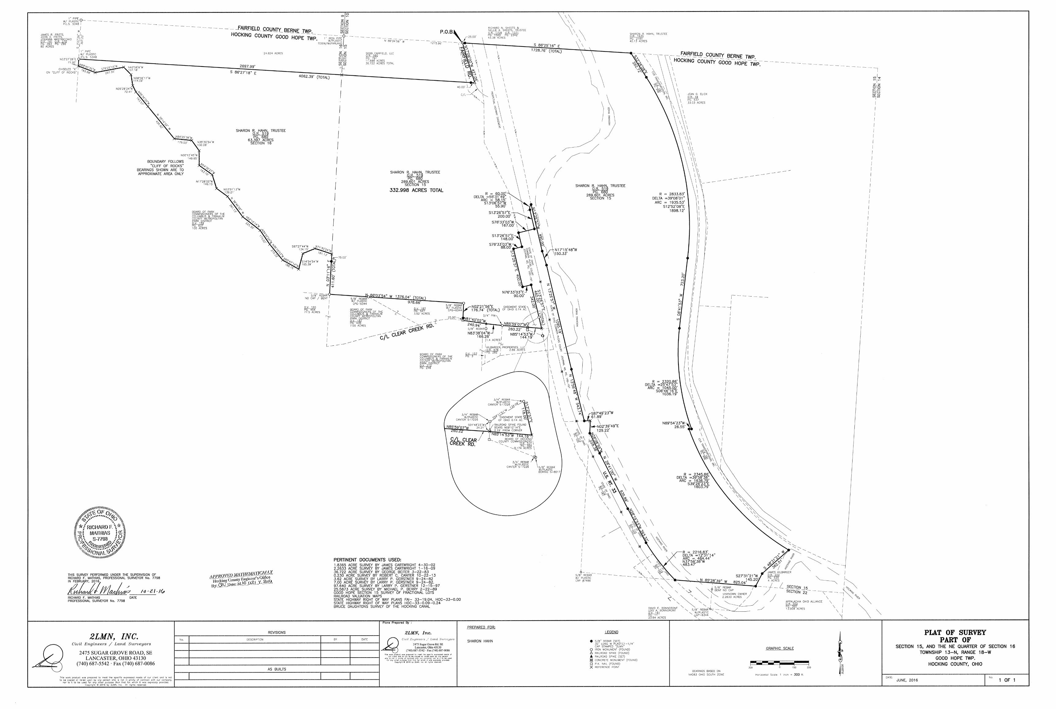
HAHN 332. 998 acre
Page I of 4 I 0/2112016
Situated in the State of Ohio, Hocking County, Good Hope Township, being part of the northeast quarter of Section 16 and part of Section 15, Township 13, Range 18, and being part of Tract One and all of Tract Two as conveyed to Sharon R. Hahn, Trustee of the Sharon R. Hahn Trust in Official Record 519, page 680 in the Hocking County Recorder's Office and being more particularly described as follows:
COMMENCING at a I inch iron pipe (found) with plastic I.D. cap Tobin-McFarland at the northwest corner of said Section 15; Thence, with the north line of said Section 15, South 86 degrees 34 minutes 56 seconds East 1215.96 feet to a railroad spike (found) in the centerline pavement of Fairfield Road, at the northeast corner of a 36. 722 acre tract conveyed to 9099 Fairfield, LLC in Official Record 580, page 791 in the Hocking County Recorder's Office and being the TRUE POlNT OF BEGINNING for the parcel herein described: c
Thence, along the north line of said Section 15, South 86 degrees 25 minutes 16 seconds East 1728.76 feet to an iron pin set on the west line of the CSX Transportation, Inc. tract conveyed in Official Record 181, page 998 in the Hocking County Recorder's Office and shown on Valuation Map V5-HV/32 and V5-HV/33, passing an iron pin set at 25 .00 feet;
Thence, with the west line of said CSX Transportation, Inc. tract the following six call: South 32 degrees 26 minutes 08 seconds East, 292. 72 feet to an iron pin (set); Thence, with a curve to the right having a radius of 2833.83 feet, a central angle of 39 degrees 08
minutes 01 seconds, an arc length of 1935.53 feet, and a chord that bears South 12 degrees 52 minutes 08 seconds East, 1898 .12 feet to an iron pin set,
Thence, South 06 degrees 41 minutes 53 seconds West, 723.20 feet to an iron pin (set); Thence, with a curve to the left having a radius of 2320.86 feet, a central angle of 25 degrees 47
minutes 53 seconds, an arc length of 1045.00 feet, and a chord that bears South 06 degrees 46 minutes 16 seconds East, 1036.19 feet to an iron pin set,
Thence, North 89 degrees 54 minutes 23 seconds West, 26.55 feet to an iron pin (set); Thence, with a curve to the left having a radius of 2345.86 feet, a central angle of 39 degrees 58
minutes 38 seconds, an arc length of 1636.79 feet, and a chord that bears South 39 degrees 26 minutes 23 seconds East, 1603. 79 feet to an iron pin set on the north line of a 4 acre tract conveyed to James Kilbarger in Official Record 222, page 535 in the Hocking County Recorder's Office
Thence, leaving the west line of the CSX Transportation, Inc. tract and with the west line of the said Kilbarger tract, South 48 degrees 31minutes21 seconds West, 362.51 feet to an iron pin set:
HAHN
332.998 acres
Page 2 of 4 10121/2016
Thence, with the west line of said Kilbarger tract, South 27 degrees 31minutes21 Seconds West, 145.20 feet to an iron pin set on the south line of said Section 15;
Thence, along the south line of said Section 15, North 85 degrees 28 minutes 39 seconds West, 825.04 feet to an iron pin set on the east LIA Line of U.S. Rt. 33;
Thence with the LI A line of U.S. Rt. 33 the following eighteen calls: Thence, with a curve to the right having a radius of 2216.83 feet, a central angle of 12 degrees 31
minutes 14 seconds, an arc length of 484.44 feet, and a chord that bears North 3 7 degrees 56 minutes 38 seconds West 483.47 feet to an iron pin set;
Thence, North 28 degrees 19 minutes 53 seconds West, 393.32 feet to an iron pin (set); Thence, North 26 degrees 41 minutes 00 seconds West, 635.89 feet to an iron pin (set); Thence, North 26 degrees 08 minutes 59 seconds West, 228.38 feet to an iron pin (set); Thence, North 02 degrees 39 minutes 49 seconds East, 129.22 feet to a point in the Hocking River; Thence, South 87 degrees 49 minutes 23 seconds West, 61.89 feet to an iron pin (set); Thence, North 13 degrees 56 minutes 48 seconds West, 543.74 feet to an iron pin (set); Thence, North 13 degrees 26 minutes 57 seconds West, l 095.19 feet to an iron pin (set); Thence, North 17 degrees 15 minutes 48 seconds West, 150.33 feet to an iron pin set; Thence, North 13 degrees 26 minutes 57 seconds West, 490.00 feet to an iron pin set; Thence, with a curve to the left having a radius of 60.00 feet, a central angle of 55 degrees 31
minutes 49 seconds, an arc length of 58.15 feet, and a chord that bears South 13 degrees 06 minutes 57 seconds West 55.90 feet to an iron pin set;
Thence, South 13 degrees 26 minutes 57 seconds East, 200.00 feet to an iron pin set; Thence, South 76 degrees 33 minutes 03 seconds West, 167 .00 feet to an iron pin set; Thence, South 13 degrees 26 minutes 57 seconds East, 148 .00 feet to an iron pin set; Thence, South 76 degrees 33 minutes 03 seconds West, 88.00 feet to an iron pin set; Thence, South 13 degrees 26 minutes 57 seconds East, 400.00 feet to an iron pin set; Thence, North 76 degrees 33 minutes 03 seconds East, 90.00 feet to an iron pin set, Thence, South 13 degrees 26 minutes 57 seconds East, 460.00 feet to a point in the centerline of
pavement of Clear Creek Road, passing a 'A inch rebar found at 342.00 feet with a Canter S-7226 I.D. plastic cap;
Thence, with the centerline of pavement of Clear Creek Road, North 85 degrees 14 minutes 53 seconds West, 144.19 feet to a point in the centerline of pavement of Clear Creek Road witnessed by a railroad spike found which bears North 09 degrees 12 minutes 14 seconds East 0.19 feet
Thence, with the centerline of pavement of Clear Creek Road, North 85 degrees 59 minutes 07 seconds West, 260.22 feet to a 'A inch iron pin found in the centerline of pavement of Clear Creek Road;
Thence, with the centerline of pavement of Clear Creek Road, North 83 degrees 38 minutes 04 seconds West, 166.26 feet to a railroad spike set in the centerline of pavement of Clear Creek Road;
HAHN 332.998 acres
Page 3 of 4 10121/2016
Thence, with the centerline of pavement of Clear Creek Road, North 81 degrees 40 minutes 02 seconds West, 240.94 feet to a railroad spike found in the centerline of pavement of Clear Creek Road at the south east corner of a 3.62 acre tract surveyed by Larry P. Gerstner September 24, 1982;
Thence with the east line of said 3.62 acre tract, North 02 degrees 21 minutes 56 seconds East, 176.74 feet to a 5/8 inch rebar found with I.D. plastic cap LPG-6344, passing an iron pin set at 25.00 feet;
Thence, with the north line of said 3.62 acre tract and the north line of a 7.00 acre tract also surveyed by Larry P. Gerstner, North 86 degrees 03 minutes 54 seconds West, 1376.04 feet to a bent 5/8 inch rebar found with no cap on the west line of said section 15, passing a 5/8 inch rebar found with I. D. plastic cap LPG-6344 at 978.66 feet;
Thence with the west line of section 15, North 03 degrees 11 minutes 16 seconds East, 411.60 teet to a point at the top of the cliff rock, passing an iron pin set at 336.60 feet;
Thence, with the windings of the top of the cliff rock to where the cliff rock hits the west line of the northeast quarter of section 16 generally following the following 21 courses;
North 71 degrees 30 minutes 24 seconds West 181.13 feet to a point; South 67 degrees 27 minutes 44 seconds West 134.15 feet to a point; South 14 degrees 54 minutes 54 seconds West 165 .39 feet to a point; North 60 degrees 47 minutes 14 seconds West 188.15 feet to a point; North 39 degrees 19 minutes 03 seconds West 210.22 feet to a point; North 34 degrees 42 minutes 04 seconds West 173 .02 feet to a point; North 52 degrees 14 minutes 14 seconds West 225.30 feet to a point; North 36 degrees 46 minutes 05 seconds West 261.13 feet to a point; North 53 degrees 51minutes13 seconds West 139.21 feet to a point; North 17 degrees 28 minutes 00 seconds West 149.15 feet to a point; North 54 degrees 39 minutes 27 seconds West 163.16 feet to a point; North 00 degrees 12 minutes 45 seconds West 149.65 feet to a point; North 35 degrees 39 minutes 54 seconds West 130.28 teet to a point; North 84 degrees 25 minutes 38 seconds West 179.03 teet to a point; North 39 degrees 14 minutes 33 seconds West 426.82 teet to a point; North 39 degrees 34 minutes 20 seconds West 193.57 feet to a point; North 26 degrees 29 minutes 24 seconds West 72.41 feet to a point; North 08 degrees 58 minutes 17 seconds West 114.09 feet to a point; North 43 degrees 5 8 minutes 06 seconds West 107 .18 feet to a point; South 79 degrees 25 minutes 15 seconds West 297.35 teet to a point; North 68 degrees 45 minutes 35 seconds West 183 .88 feet to a chiseled "X" in the cliff rock;
Thence, leaving the cliff rock and along the said west line of the northeast quarter of section 16, North 03 degrees 27 minutes 28 seconds East, 71.90 feet to a 1 inch iron pipe found with a I.D. plastic cap P.L.S.-5348 at the southwest corner of a 36. 722 acre tract surveyed by George Beiter March 22, 1983;
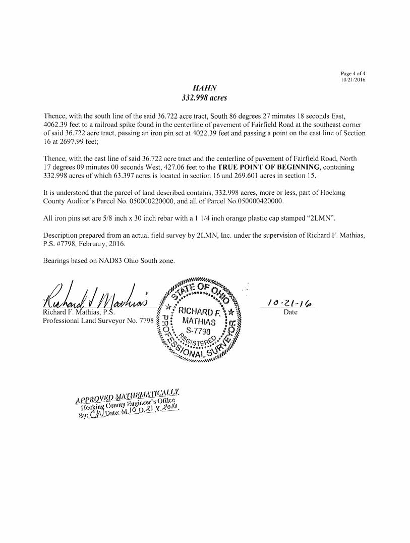
HAHN 332.998 acres
Page 4 of 4 l0i2 li2016
Thence, with the south line of the said 36.722 acre tract, South 86 degrees 27 minutes 18 seconds East, 4062.39 feet to a railroad spike found in the centerline of pavement of Fairfield Road at the southeast corner of said 36. 722 acre tract, passing an iron pin set at 4022.39 feet and passing a point on the east line of Section 16 at 2697.99 feet;
Thence, with the east line of said 36.722 acre tract and the centerline of pavement of Fairfield Road, North 17 degrees 09 minutes 00 seconds West, 427.06 feet to the TRUE POINT OF BEGINNING, containing 332.998 acres of which 63.397 acres is located in section 16 and 269.601 acres in section 15.
It is understood that the parcel of land described contains, 332.998 acres, more or less, part of Hocking County Auditor's Parcel No. 050000220000, and all of Parcel No.050000420000.
All iron pins set are 5/8 inch x 30 inch rebar with a 1 1/4 inch orange plastic cap stamped "2LMN".
Description prepared from an actual field survey by 2LMN, Inc. under the supervision of Richard F. Mathias, P.S. #7798, February, 2016.
Bearings based on NAD83 Ohio South zone.
/tJ ·Z./-L~-oate
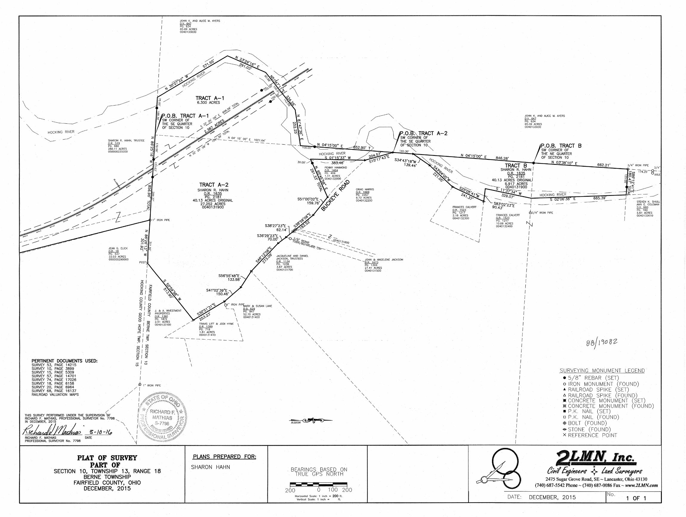
\
HOCKING RIVER
~ ~ SHARON R. HAHN. TRUSTEE .QJL2lll PG. 680 280.11 ACRES 050000220000
JEAN G. ELICK .QJLlll PG. 637
1" IRON PIPE
JOHN K. AND ALICE M. AYERS D.V. 647 PG. 634 65.09 ACRES 0040133030
TRACT A-1 6.300 ACRES
TRACT A-2 SHARON R. HAHN
O.R. 1635 PG. 2181
40.13 ACRES ORIGINAL 27.252 ACRES 0040131900
S38"27'23"E 62.14'
S36"29'23"E 70.00'
-.::::-- ---- ..__ --- -- -- - ":?'"
-- -- --.. --- z:::- --5/8" ....... --- 0 lo§!N}jf8Af? .._ --. -._ "-"-O:f:.9_1J1600
McFAf<r • . -._ .....__ .....__
CRAIG HARRIS 0.R. 1669 PG. 2267 8.72 ACRES 0040132200
v;/i/r) ,..,.__ .....__ -.._ .._.r.ip-......_ .._ --
--.. --- -- -- -..... ----.. -- -- ----- - ---33.03 ACRES
050000290000 JACQUELINE AND DANIEL JACKSON, TRUSTEES O.R. 1134
--- -._ JOHN & ANGELENE JACKSON
51 ~I~ z I ::u G) :::!:!
fTJ o I ro 0
'-'-
'-'-
'-"'
c/o ~lg
1" IRON PIPfMARK & SUSAN LANE
PERTINENT DOCUMENTS USED:
z 8 I =< 01 0 CD :r: I !;j O/z ;:;; fTJ
:g I :g :o I :u U) I ~ 81Q -l -0/0 z z ~lo ()1 I
I I
J. & A. INVESTMENT PROPERTIES OR. 1360 PG. 1872 2.51 ACRES 0040132100
I~ \ 52. 70 ACRES
0040131400
\ / / TRAVIS LIFF & JODI HYME \
_D.R. 1399 / / PG. 719 \
,, 1.81 ACRES / 0040131410 \ L __
-,----------_j \ \ \ \ \ SURVEY 53, PAGE 14215
SURVEY 10, PAGE 3899 SURVEY 15, PAGE 5309 SURVEY 57, PAGE 14701 SURVEY 74, PAGE 17026 SURVEY 18, PAGE 6158 SURVEY 20, PAGE 6964 SURVEY 68, PAGE 16137 RAILROAD VALUATION MAPS
JD 1 " IRON PIPE
/f // I
/ / I
/ THIS SURVEY PERFORMED UNDER THE SUPERVISION ~ RICHARD F. MATHIAS, PROFESSIONAL SURVEYOR No. 7798 ---.__
?:z:JJ~. g-/0-1(,, '\ RICHARD F. MATHIAS DATE \ / PROFESSIONAL SURVEYOR No. 7798 \j
PLAT OF SURVEY PART OF
SECTION 10, TOWNSHIP 13, RANGE 18 BERNE TOWNSHIP
FAIRFIELD COUNTY, OHIO DECEMBER, 2015
PLANS PREPARED FOR:
SHARON HAHN
PG. 1238 3.67 ACRES 0040131700
"' '-'-
'-'-
'-
"' '-'-
'-'-
'-'-
'-'-
'-'-
'-"' '-
BEARINGS BASED ON TRUE GPS NORTH
"'
r---- I ' I
'-
200 0 100 200 Horizontal Scale: 1 inch = 200 ft.
Vertical Scale: 1 inch = ft.
'-'-
----0.R. 1673
'-
PG. 1304 27.41 ACRES 0040131500
'-
"' '-'-
'-'-
'-'-
'-'-
''-
FRANCES CALVERT O.R. 1523 PG. 1217 10.06 ACRES 0040132400
JOHN K. AND ALICE M. AYERS _Q,y,__Mz PG. 634 65.09 ACRES 0040133030
cb3/ 4" IRON PIPE
I
~ I I I I I I I I I I I I I I
I I I I
STEVEN K. SHULL ANN E. COLEMAN o.v. 660 PG. 160 5.61 ACRES 0040132610
I I I I I I I I I I I I I I I I I I I I I I I I I I
DATE:
SURVEYING MONUMENT LEGEND • 5/8" REBAR (SET) o IRON MONUMENT (FOUND) _.. RAILROAD SPIKE (SET) D. RAILROAD SPIKE (FOUND) :.: CONCRETE MONUMENT (SET) ~CONCRETE MONUMENT (FOUND) • P.K. NAIL (SET) o P.K. NAIL (FOUND) -$-BOLT (FOUND) $STONE (FOUND) x REFERENCE POINT
1 Inc. OtP-tf Efff!lru~ +. Ltl/(I tfq~ff
2475 Sugar Grove Road, SE - Lancaster, Ohio 43130 (740) 687-5542 Phone - (740) 687•0086 Fax - www.2LMN.com
DECEMBER, 2015 No.
1 OF 1
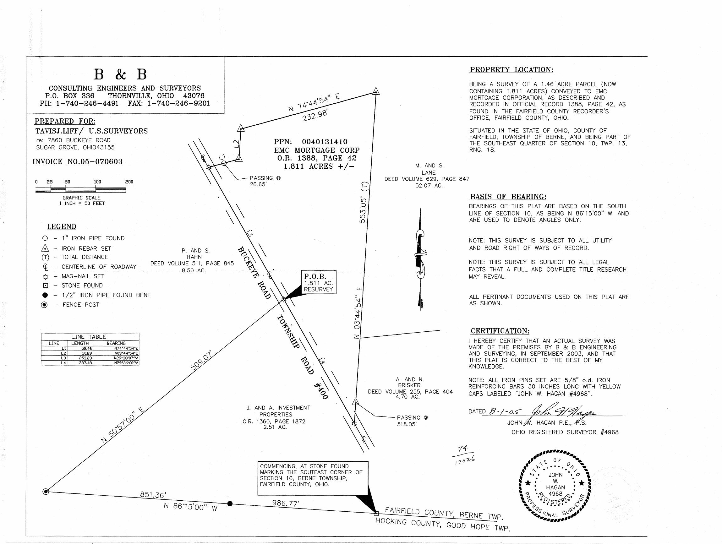
B & B CONSULTING ENGINEERS AND SURVEYORS
P .0. BOX 336 THORNVILLE, OHIO 43076 PH: 1-740-246-4491 FAX: 1-740-246-9201
PREPARED FOR: TAVISJ.LIFF I U.S.SURVEYORS re: 7860 BUCKEYE ROAD SUGAR GROVE, OHI043155
INVOICE N0.05-070603
0 25 50 100 200
I '~--IE:==:~I GRAPHIC SCALE
1 INCH = 50 FEET
LEGEND
0 - 1" IRON PIPE FOUND
B - IRON REBAR SET
(T) - TOTAL DISTANCE P. AND S.
HAHN
N -1
ct_ - CENTERLINE OF ROADWAY DEED VOLUME 511, PAGE 845
8.50 AC. ¢ - MAG-NAIL SET
[] - STONE FOUND
e - 1 /2" IRON PIPE FOUND BENT
@ - FENCE POST
LINE TABLE LINE LENGTH BEARING
L1 52.46 N74°44'54'E L2 50.29 N03°44'54'E L3 253.23 N29°38'07'VI L4 237.48 N29°36'00'VI
851.36'
N 86°15'00" W
PPN: 0040131410 EMC MORTGAGE CORP O.R. 1388, PAGE 42
1.811 ACRES + /-PASSING @
213.65' !='
P.O.B. 1 .811 AC. RESURVEY
"--"' ... I.[) 0 . !"') I.[) I.[)
w
I") 0
M. AND S. LANE
PROPERTY LOCATION:
BEING A SURVEY OF A 1.46 ACRE PARCEL (NOW CONTAINING 1.811 ACRES) CONVEYED TO EMC MORTGAGE CORPORATION, AS DESCRIBED AND RECORDED IN OFFICIAL RECORD 1388, PAGE 42, AS FOUND IN THE FAIRFIELD COUNTY RECORDER'S OFFICE, FAIRFIELD COUNTY, OHIO.
SITUATED IN THE STATE OF OHIO, COUNTY OF FAIRFIELD, TOWNSHIP OF BERNE, AND BEING PART OF THE SOUTHEAST QUARTER OF SECTION 10, TWP. 13, RNG. 18.
DEED VOLUME 629, PAGE 847 52.07 AC.
BASIS OF BEARING: BEARINGS OF THIS PLAT ARE BASED ON THE SOUTH LINE OF SECTION 10, AS BEING N 86°15'00" W, AND ARE USED TO DENOTE ANGLES ONLY.
NOTE: THIS SURVEY IS SUBJECT TO ALL UTILITY AND ROAD RIGHT OF WAYS OF RECORD.
NOTE: THIS SURVEY IS SUBJECT TO ALL LEGAL FACTS THAT A FULL AND COMPLETE TITLE RESEARCH MAY REVEAL.
ALL PERTINANT DOCUMENTS USED ON THIS PLAT ARE AS SHOWN.
zL------ CERTIFICATION: I HEREBY CERTIFY THAT AN ACTUAL SURVEY WAS MADE OF THE PREMISES BY B & B ENGINEERING AND SURVEYING, IN SEPTEMBER 2003, AND THAT THIS PLAT IS CORRECT TO THE BEST OF MY KNOWLEDGE.
J. AND A. INVESTMENT PROPERTIES
O.R. 1360, PAGE 1872 2.51 AC.
COMMENCING, AT STONE FOUND MARKING THE SOUTEAST CORNER OF SECTION 10, BERNE TOWNSHIP, FAIRFIELD COUNTY, OHIO.
986. 77'
A. AND N. BRISKER
DEED VOLUME 255, PAGE 404 4.70 AC.
--- PASSING @
518.05'
NOTE: ALL IRON PINS SET ARE 5/8" o.d. IRON REINFORCING BARS 30 INCHES LONG WITH YELLOW CAPS LABELED "JOHN W. HAGAN #4968".
DATED 8-/-o.5 ~~ JOHN~PE.~
OHIO REGISTERED SURVEYOR #4968
--······· ,, ... ff '\ ~ 0 F O • ....
•• ~ • • • • • ,y ... ... ~ . . / -I ":> • JOHN • • 0 \
~ * : w. •• * I ! 0 HAGAN • ~· ~ . . ~
\ --0 ·~ 4968 <:). ~. ~ - 1)0 • f'c1 co<.<:... 0 ' • ~ • STt.-"• ~ •9 ... ~ . . . . . ~~ ...
•,. Ss 0~ .. t . ••. IQNAL S 1fr ... , ..... -FAIRFIELD COUNTY, BERNE TWP
HOCKING COUNTY, GOOD HOPE . TWP.
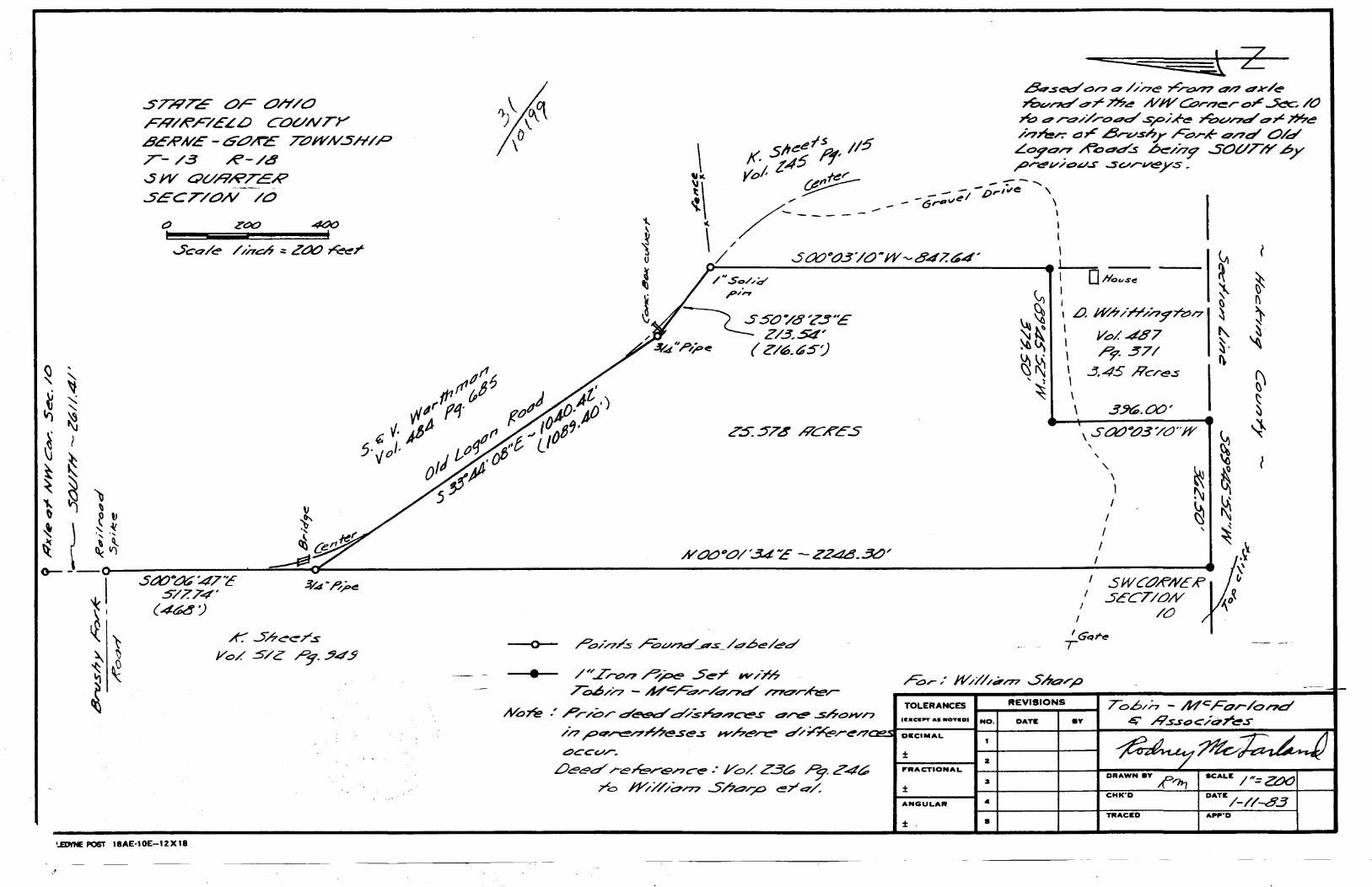
..5T/i'TE OF Oh'/O FR/A'/9'ELLJ COUNTY BERNE - 6.t:7/tc 727WN..5H/P T- /.3 R-/4 SWOVRRTC:R SECT/ON /0
•..£DttoE POST IBAE·IOE-12X18
• /'7.ro-'? ~~ .5e7"' ff"'/)".6
ToLJ/n - ~4C/=d.,-/c:r/?e:r /770-r~.....
~.s<='d" c::>'7 a ///7e .,,c,,..°'77 e?/? er-Y/~
T&vl"'ild" dr ?>?~ A/11/ ~rn~r or~ /CJ J"'.o .::?r~//.ro..::?d .s,,o/;if-e 7""bv/7d .::?~ ~~ / .. •·n~r.- e:Jr ..8....-.vsh.r Fork and O/d Loyo/7 ....t='oe?ds ~/nf' SOUTl'Y ..6y _,ord'v;o~..s ..svrv~ys.
~ ~ (')
, LJ. wn /H"n:J'm.17 ~ I I Vt::>/. 48 7 I ~37/ I .5.45 Heres I \
\
(
~ I\
~ ~·
~
~ § ~
l
ToLERANcES ._._R_E_v_19_10_N"Ts _ __, To.6/n - Mc:For/o/?d No.7i?- .' Pr/br d~ ~.Src?.-?~s e?~ ..s.6o>Yn 1aac•PTa ... ouD1 No. DATE .v c:' .R.s.soc/t:77'~s
/n~4'~/'?~~e.ses n'Ar~/"l:"' ~~~ren,·__,,...J-o-.-c,-M-AL-----1S..:..:..:.+--~~-l-~--lf----------::;:~--::---:;n <:?CCV/". ±
LJeC'd" .r-ekr'9;>?Ce>: J/o/. Z3~ ~ ?4~
ro J"YX///~rn .5.hc::?...p ere?/. DATE /-//-83
z P'RACTIONAL
3 ± ANGULAR •
DRAWN BY ~,,,,_,
CHK'D
TRACED APP"D
± •
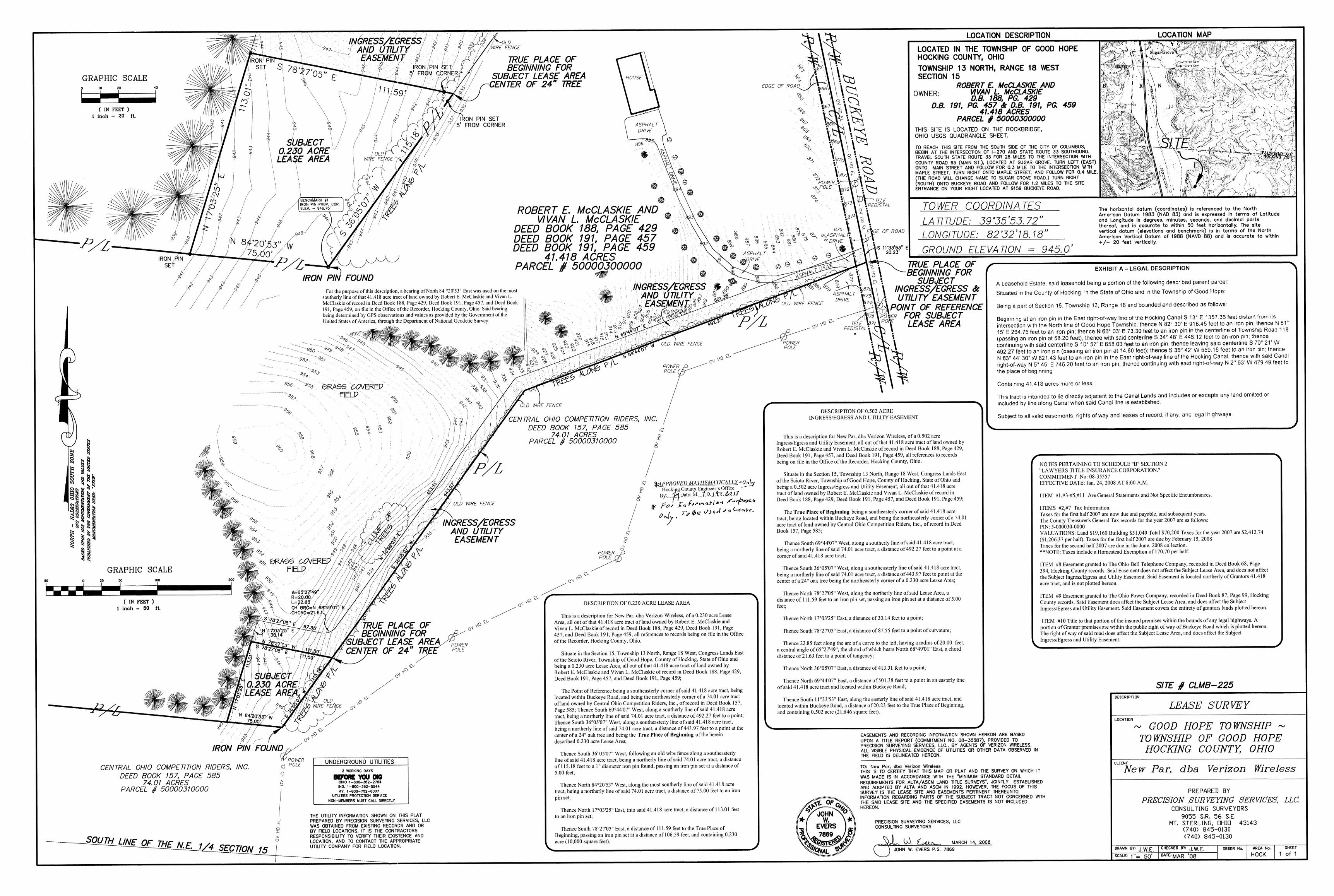
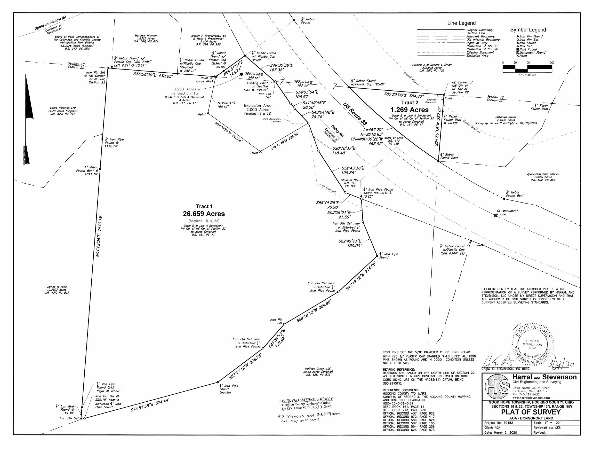
----
itd t-10llOW ,,.-
551.lrtl P~f 0pO ~rfi1'18c't'i~Ol'I / ce .. strll co fl
Boord of Pork Commissioners of the Columbus ond Fronk/in County
Metropolitan Park Distnct 48.3276 Acres (original)
D.B. 213. PG 250
Matthew Hitsman 1.8365 Acres
0.R. 586. PG 824
~
I \
\
Joseph P Prendergast, Sr. & Molly L Prendergast
5.104 Acres O.R. 594, PG 256
I ~ H Rebar Found w/ ~" Rebar Found Plastic Cap "JRC 7486" . /pt c
S.. ec•,·on 15 l t,t 621 , ... 1591 , w/' astlc op " e . .,, . .1
Secbon 22~ 1:~~...z.---------:;~~~?{}~'"'4,J8~~-l~(i~il/.~eg~i§bt~e/~--~~--~~~ @ 282.13' Iron Pin Set S85'.2B ~'O ''£:- 4. 70• 6.'5'
@ NW Carner 1;;. vo. of NE Otr,
Section 22
Eagle Holdings LTO 14.70 Acres (original)
O.R. 572, PG 417
/ /
James H Funk 19.2507 Acres
O.R. 437, PG 829
/
1" Rebar Found Bent @
1011.18'
i" Iron Pipe Found@ 1132.14'
0.259 in Section 15
David E & Lois A Bonnoront 3 Acres
0.8. 161, PG 11
Tract 1
26.659 Acres (Sections 1 5 & 22)
David E & Lois A Bonnoront NW Otr of NE Otr of Section 22
40 Acres (original) D.8. 161, PG 11
\ / \\ /\
\ / \
\ ~"Rebar Found
\ \
\ \
\
\
\
\
\
\
Line Legend ~~~~~~~~~~~ Subject Boundary
---- Section Line --- Adjacent Boundary
Old Internal Boundary
Symbol Legend •Iron Pin Found 0 Iron Pin Set A.Nail Found &.Nail Set < \
f' Rebar Found \ w/ Plastic Cap "2LMN" \
549'30 136NE \
\
\ \
\
---- Right-of-Way Centerline of US 33 Centerline of Co. Rd Existing Easement
----------- Excwsron Area
Michael J & Sondra L Smith 332.998 Acres
0
•Post Found EJMonument Found XPoint
50 100 200
163.38' \
" S85;29\'Jo~ \
\
O.R. 587, PG 105 ~ / 302.70'
"'
CJ.so~ ...,?C'J,....."'-
~" Rebar Found ~""\ NE Comer of w/Plastic Cap "2LMN" "'"">.,,~ \ NW Otr of
1" = 100 Feet
Passing Point on Section
line @ 159.44' --534'53'04 ''E
106.57' ~°t:~~~~::-----~----~5;;;;;,q:~;:;;~::;:~~~\~ ..... _,..~~~M~E~,Ou of Section 22 ~ S85'.29'oo ''£ 384. 47,
~ecfton 15 Sect/on 22
j" Re-;;;-1-Found t!e~~1
I Exclusion Area
2.000 Acres (Sections 1 5 & 22)
Work Agreement---.--......... , Easement -\.
~~ Tract2 26.58 ' "'~ 1 269 A
s43·04 '48''E ~~ • cres 7.•n. 74 1 ~~ Davia E & Lois A Bonnoront
'7 .. ~ NW Otr of NE Otr of Section 22 ~ 40 Acres (original)
D.B. 161, PG 11
Cl ~~ L=467.79'---C!"'-:> '&.. 0-:>~-?,(~ ~ R=2216.83'
'?..":~ 0~<>- CH=N50•30 '22 "W State of Ohio ~ aa 1~
\ 466.92' PG 169
520'18'.3711£ ~ 118.48' ~ /~ ~
~ / ~ ~ S32'43'36''E J ~ ~ I
" ti." " o Rebar " Unknown Owner Found Bent "'" 2.2633 Acres / @ 66.28' "'0 ,," Survey by James R Cartright in 01/16/2009
~6'/ <!; ............
Q.$>6> ............
"""' " ,,,, '
- _/ I
I
199.66' / ~ ~'-~I State of Ohio/ ~ ~
D.B. 112 \ "' PG 168 1.
i" Iron Pipe Found ~
' '
~ '"Reba'
Appalachia Ohio Alliance 13.009 Acres
O.R. 502, PG 360
bears N03"29'o1 "E ~ '- 8
568' 44 '56 ''E 70.98' S03'29'o1 't::
91.50'
10.65' "' I ~ ' Found Bent
~-
Iron Pin Set near a disturbed -:J "
Iron Pipe Found
Iron Pin Set near a disturbed ":f "
Iron Pipe Found
S22'49'13''E____,,./ 150.001
-- ~ ~ 1"~
-~ CL Monument ~Found
Pipe
--.._
~ --~ ',,' ." I ~ ~,
I ~"Rebar Found"'Jr~ '---._ ----~~ w/Plastic Cap ~ "'
!PG 6344" (21 --~ .. ·.,
I I --~, I I I I
I HEREBY CERTIFY THAT THE ATTACHED PLAT IS A TRUE REPRESENTATION OF A SURVEY PERFORMED BY HARRAL AND STEVENSON, LLC UNDER MY DIRECT SUPERVISION AND THAT THE ACCURACY OF SAID SURVEY IS CONSISTENT WITH CURRENT ACCEPTED SURVEYING STANDARDS.
Iron Pin Set near a disturbed -:J"
Iron Pipe Found iJ
~"Iron Rod\ Found@
19.38'
Iron
~"Iron Pipe Found 0.45' Right @ 48.58'
Iron Pin Set @ 559.15' near a disturbed -:J " Iron Pipe Found
-:J" Iron Pipe Found leaning
Mathias Grove, LLC 25.83 Acres (on"ginal)
O.R. 626, PG 873
IRON PINS SET ARE 5/8" DIAMETER X 30" LONG REBAR WITH RED 1f' PLASTIC CAP STAMPED "H&S 8592" ALL IRON PINS SHOWN AS FOUND ARE IN GOOD CONDITION UNLESS NOTED OTHERWISE.
BEARING REFERENCE: BEARINGS ARE BASED ON THE NORTH LINE OF SECTION 22 AS DETERMINED BY GPS OBSERVATION BASED ON ODOT CORS USING VRS ON THE NAD83{11) DATUM, BEING S85'29'00"E.
REFERENCE DOCUMENTS: HOCKING COUNTY TAX MAPS SURVEYS OF RECORD IN THE HOCKING COUNTY MAPPING AND DRAFTING DEPARTMENT HOC-33-0.09-0.24 DEED BOOK 161 , PAGE 11 DEED BOOK 213, PAGE 250 OFFICIAL RECORD 437, PAGE 829 OFFICIAL RECORD 572, PAGE 417 OFFICIAL RECORD 586, PAGE 824 OFFICIAL RECORD 587, PAGE 105 OFFICIAL RECORD 594, PAGE 256 OFFICIAL RECORD 626, PAGE 873
Harral and Stevenson Civil Engineering and Surveying
2869 North Court Street Circleville, Ohio 43113 Ph: 7 40.497 .4432 www.horralstevenson.com
GOOD HOPE TOWNSHIP, HOCKING COUNTY, OHIO SECTIONS 15 & 22, TOWNSHIP 13N, RANGE 18W
PLAT OF SURVEY AOA-BONNORONTLAND
Project No: S0482 Scale: 1" = 100'
Client: AOA Reviewed by: CES
Date: March 2, 2020 Revised:
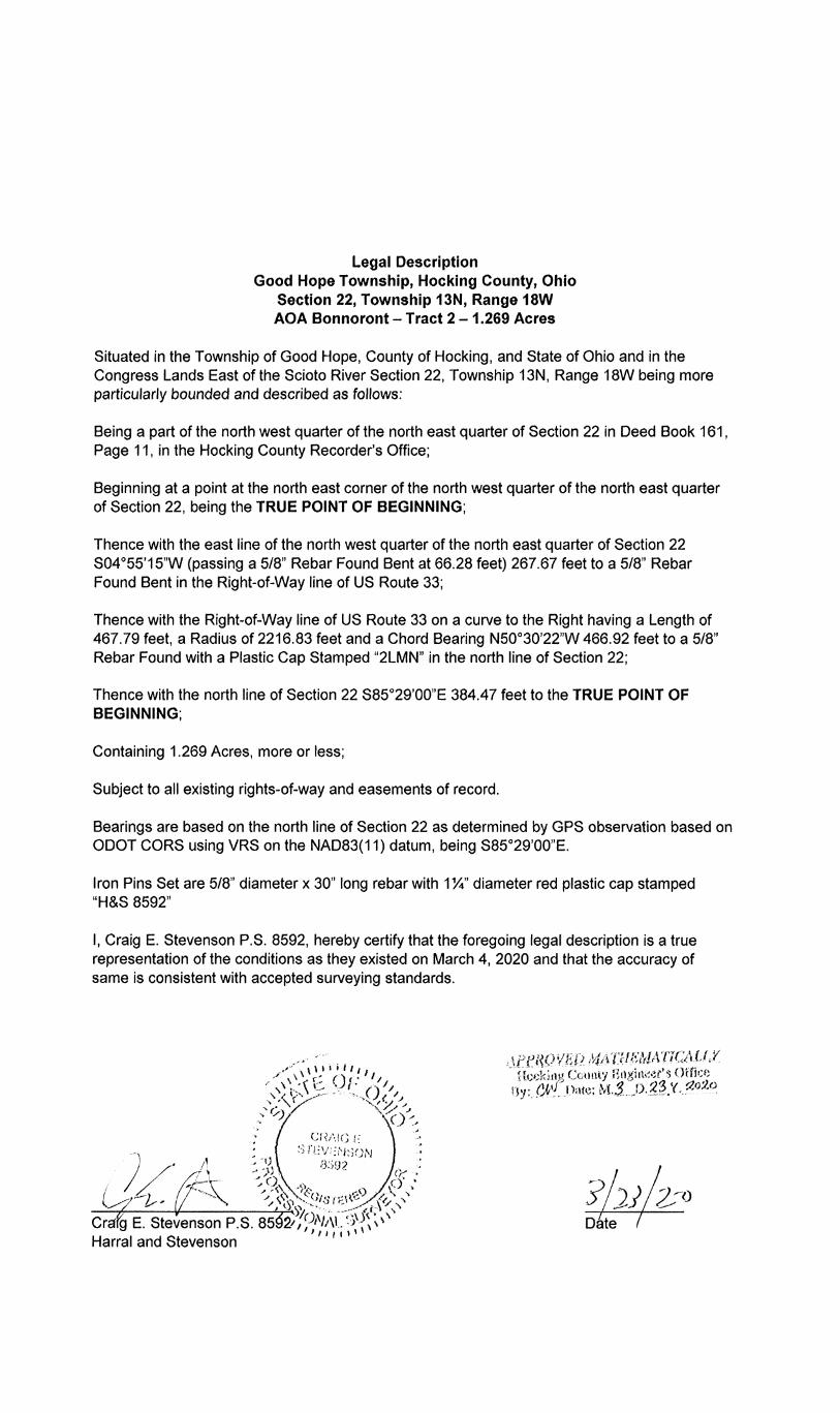
Legal Description Good Hope Township, Hocking County, Ohio
Section 22, Township 13N, Range 18W AOA Bonnoront - Tract 2 - 1.269 Acres
Situated in the Township of Good Hope, County of Hocking, and State of Ohio and in the Congress Lands East of the Scioto River Section 22, Township 13N, Range 18W being more particularly bounded and described as follows:
Being a part of the north west quarter of the north east quarter of Section 22 in Deed Book 161, Page 11, in the Hocking County Recorder's Office;
Beginning at a point at the north east corner of the north west quarter of the north east quarter of Section 22, being the TRUE POINT OF BEGINNING;
Thence with the east line of the north west quarter of the north east quarter of Section 22 S04°55'15"W (passing a 5/8" Rebar Found Bent at 66.28 feet) 267.67 feet to a 5/8" Rebar Found Bent in the Right-of-Way line of US Route 33;
Thence with the Right-of-Way line of US Route 33 on a curve to the Right having a Length of 467.79 feet, a Radius of 2216.83 feet and a Chord Bearing N50°30'22"W 466.92 feet to a 5/8" Rebar Found with a Plastic Cap Stamped "2LMN" in the north line of Section 22;
Thence with the north line of Section 22 S85°29'00"E 384.47 feet to the TRUE POINT OF BEGINNING;
Containing 1.269 Acres, more or less;
Subject to all existing rights-of-way and easements of record.
Bearings are based on the north line of Section 22 as determined by GPS observation based on ODOT CORS using VRS on the NAD83(11) datum, being S85°29'00"E.
Iron Pins Set are 5/8" diameter x 30" long rebar with 1 %" diameter red plastic cap stamped "H&S 8592"
I, Craig E. Stevenson P.S. 8592, hereby certify that the foregoing legal description is a true representation of the conditions as they existed on March 4, 2020 and that the accuracy of same is consistent with accepted surveying standards.
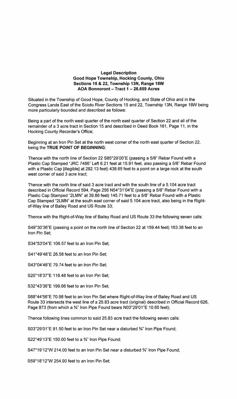
Legal Description Good Hope Township, Hocking County, Ohio Sections 15 & 22, Township 13N, Range 18W
AOA Bonnoront - Tract 1 - 26.659 Acres
Situated in the Township of Good Hope, County of Hocking, and State of Ohio and in the Congress Lands East of the Scioto River Sections 15 and 22, Township 13N, Range 18W being more particularly bounded and described as follows:
Being a part of the north west quarter of the north east quarter of Section 22 and all of the remainder of a 3 acre tract in Section 15 and described in Deed Book 161, Page 11, in the Hocking County Recorder's Office;
Beginning at an Iron Pin Set at the north west corner of the north east quarter of Section 22, being the TRUE POINT OF BEGINNING;
Thence with the north line of Section 22 S85°29'00"E (passing a 5/8" Rebar Found with a Plastic Cap Stamped "JRC 7486" Left 6.21 feet at 15.91 feet, also passing a 5/8" Rebar Found with a Plastic Cap [illegible] at 282.13 feet) 438.65 feet to a point on a large rock at the south west corner of said 3 acre tract;
Thence with the north line of said 3 acre tract and with the south line of a 5.104 acre tract described in Official Record 594, Page 256 N54°31 '04"E (passing a 5/8" Rebar Found with a Plastic Cap Stamped "2LMN" at 39.86 feet) 145.71 feet to a 5/8" Rebar Found with a Plastic Cap Stamped "2LMN" at the south east corner of said 5.104 acre tract, also being in the Rightof-Way line of Bailey Road and US Route 33;
Thence with the Right-of-Way line of Bailey Road and US Route 33 the following seven calls:
S49°30'36"E (passing a point on the north line of Section 22 at 159.44 feet) 163.38 feet to an Iron Pin Set;
S34°53'04"E 106.57 feet to an Iron Pin Set;
S41°49'48"E 26.58 feet to an Iron Pin Set;
S43°04'48"E 79.74 feet to an Iron Pin Set;
S20°18'37"E 118.48 feet to an Iron Pin Set;
S32°43'36"E 199.66 feet to an Iron Pin Set;
S68°44'56"E 70.98 feet to an Iron Pin Set where Right-of-Way line of Bailey Road and US Route 33 intersects the west line of a 25.83 acre tract (original) described in Official Record 626, Page 873 (from which a%" Iron Pipe Found bears N03°29'01"E 10.65 feet);
Thence following lines common to said 25.83 acre tract the following seven calls:
S03°29'01 "E 91.50 feet to an Iron Pin Set near a disturbed %" Iron Pipe Found;
S22°49'13"E 150.00 feet to a%" Iron Pipe Found;
S47°19'12"W 214.00 feet to an Iron Pin Set near a disturbed%" Iron Pipe Found;
S59°18'12"W 254.90 feet to an Iron Pin Set;
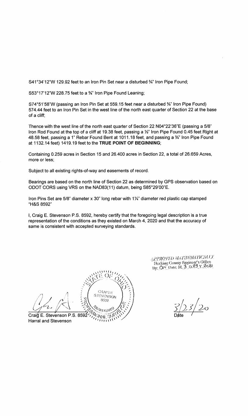
S41°34'12"W 129.92 feet to an Iron Pin Set near a disturbed%" Iron Pipe Found;
S53°17'12"W 228.75 feet to a%" Iron Pipe Found Leaning;
S7 4 °51 '58"W (passing an Iron Pin Set at 559.15 feet near a disturbed %" Iron Pipe Found) 574.44 feet to an Iron Pin Set in the west line of the north east quarter of Section 22 at the base of a cliff;
Thence with the west line of the north east quarter of Section 22 N04°22'36"E (passing a 5/8" Iron Rod Found at the top of a cliff at 19.38 feet, passing a Ya" Iron Pipe Found 0.45 feet Right at 48.58 feet, passing a 1" Rebar Found Bent at 1011.18 feet, and passing a %" Iron Pipe Found at 1132.14 feet) 1419.19 feet to the TRUE POINT OF BEGINNING;
Containing 0.259 acres in Section 15 and 26.400 acres in Section 22, a total of 26.659 Acres, more or less;
Subject to all existing rights-of-way and easements of record.
Bearings are based on the north line of Section 22 as determined by GPS observation based on ODOT CORS using VRS on the NAD83(11) datum, being S85°29'00"E.
Iron Pins Set are 5/8" diameter x 30" long rebar with 1 %" diameter red plastic cap stamped "H&S 8592"
I, Craig E. Stevenson P.S. 8592, hereby certify that the foregoing legal description is a true representation of the conditions as they existed on March 4, 2020 and that the accuracy of same is consistent with accepted surveying standards.
J/21po D te
Legal Description Good Hope Township, Hocking County, Ohio
Section 22, Township 13N, Range 18W AOA Bonnoront - Tract 1 Less Exclusion Area - 24.659 Acres
Situated in the Township of Good Hope, County of Hocking, and State of Ohio and in the Congress Lands East of the Scioto River Section 22, Township 13N, Range 18W being more particularly bounded and described as follows:
Being a part of the north west quarter of the north east quarter of Section 22;
Beginning at an Iron Pin Set at the north west corner of the north east quarter of Section 22, being the TRUE POINT OF BEGINNING;
Thence with the north line of Section 22 S85°29'00"E (passing a 518" Rebar Found with a Plastic Cap Stamped "JRC 7486" Left 6.21 feet at 15.91 feet, also passing a 518" Rebar Found with a Plastic Cap [illegible] at 282.13 feet) 438.65 feet to a point on a large rock at the south west corner of a 3 acre tract described in Deed Book 161, Page 11;
Thence through the north west quarter of the north east quarter of Section 22 the following three calls:
S12°08'31"W 150.43 feet to a point;
S54°07'50"E 262.54 feet to a point;
N59°41'49"E 225.78 feet to an Iron Pin Set in the Right-of-Way of Bailey Road and US Route 33;
Thence with the Right-of-Way line of Bailey Road and US Route 33 the following three calls:
S20°18'37"E 118.48 feet to an Iron Pin Set;
S32°43'36"E 199.66 feet to an Iron Pin Set;
S68°44'56"E 70.98 feet to an Iron Pin Set where Right-of-Way line of Bailey Road and US Route 33 intersects the west line of a 25.83 acre tract (original) described in Official Record 626, Page 873 (from which a%" Iron Pipe Found bears N03°29'01"E 10.65 feet);
Thence following lines common to said 25.83 acre tract the following seven calls:
S03°29'01"E 91.50 feet to an Iron Pin Set near a disturbed%" Iron Pipe Found;
S22°49'13"E 150.00 feet to a%" Iron Pipe Found;
S47°19'12"W 214.00 feet to an Iron Pin Set near a disturbed%" Iron Pipe Found;
S59°18'12"W 254.90 feet to an Iron Pin Set;
S41°34'12"W 129.92 feet to an Iron Pin Set near a disturbed%" Iron Pipe Found;
S53°17'12"W 228.75 feet to a%" Iron Pipe Found Leaning;
S74°51'58"W (passing an Iron Pin Set at 559.15 feet near a disturbed%" Iron Pipe Found) 574.44 feet to an Iron Pin Set in the west line of the north east quarter of Section 22 at the base of a cliff;
Thence with the west line of the north east quarter of Section 22 N04°22'36"E (passing a 5/8" Iron Rod Found at the top of a cliff at 19.38 feet, passing a Y2" Iron Pipe Found 0.45 feet Right at 48.58 feet, passing a 1" Rebar Found Bent at 1011.18 feet, and passing a %" Iron Pipe Found at 1132.14 feet) 1419.19 feet to the TRUE POINT OF BEGINNING;
Containing, a total of 24.659 Acres, more or less;
Subject to all existing rights-of-way and easements of record.
Bearings are based on the north line of Section 22 as determined by GPS observation based on ODOT CORS using VRS on the NAD83(11) datum, being S85°29'00"E.
Iron Pins Set are 5/8" diameter x 30" long rebar with 1 X" diameter red plastic cap stamped "H&S 8592"
I, Craig E. Stevenson P.S. 8592, hereby certify that the foregoing legal description is a true representation of the conditions as they existed on March 4, 2020 and that the accuracy of same is consistent with accepted surveying standards.
~'I J ,.) } ') CJ
~
Legal Description Good Hope Township, Hocking County, Ohio Sections 15 & 22, Township 13N, Range 18W
AOA Bonnoront - Exclusion Area - 2.000 Acres
Situated in the Township of Good Hope, County of Hocking, and State of Ohio and in the Congress Lands East of the Scioto River Sections 15 and 22, Township 13N, Range 18W being more particularly bounded and described as follows:
Being a part of the north west quarter of the north east quarter of Section 22 and all of the remainder of a 3 acre tract in Section 15 and described in Deed Book 161, Page 11, in the Hocking County Recorder's Office;
Beginning for reference at an Iron Pin Set at the north west corner of the north east quarter of Section 22;
Thence with the north line of Section 22 S85°29'00"E (passing a 5/8" Rebar Found with a Plastic Cap Stamped "JRC 7486" Left 6.21 feet at 15.91 feet, also passing a 5/8" Rebar Found with a Plastic Cap [illegible] at 282.13 feet) 438.65 feet to a point on a large rock at the south west corner of said 3 acre tract, being the TRUE POINT OF BEGINNING;
Thence with the north line of said 3 acre tract and with the south line of a 5.104 acre tract described in Official Record 594, Page 256 N54°31'04"E (passing a 5/8" Rebar Found with a Plastic Cap Stamped "2LMN" at 39.86 feet) 145. 71 feet to a 518" Rebar Found with a Plastic Cap Stamped "2LMN" at the south east corner of said 5.104 acre tract, also being in the Rightof-Way line of Bailey Road and US Route 33;
Thence with the Right-of-Way line of Bailey Road and US Route 33 the following four calls:
S49°30'36"E (passing a point on the north line of Section 22 at 159.44 feet) 163.38 feet to an Iron Pin Set;
S34°53'04"E 106.57 feet to an Iron Pin Set;
S41°49'48"E 26.58 feet to an Iron Pin Set;
S43°04'48"E 79.74 feet to an Iron Pin Set;
Thence through the north west quarter of the north east quarter of Section 22 the following three calls:
S59°41'49"W 225.78 feet to a point;
N54°07'50"W 262.54 feet to a point;
N12°08'31"E 150.43 feet to the TRUE POINT OF BEGINNING;
Containing 0.259 acres in Section 15 and 1.741 acres in Section 22, a total of 2.000 Acres, more or less;
Subject to all existing rights-of-way and easements of record.
Bearings are based on the north line of Section 22 as determined by GPS observation based on ODOT CORS using VRS on the NAD83(11) datum, being S85°29'00"E.
Iron Pins Set are 5/8" diameter x 30" long rebar with 1 Y.i" diameter red plastic cap stamped "H&S 8592"
I, Craig E. Stevenson P.S. 8592, hereby certify that the foregoing legal description is a true representation of the conditions as they existed on March 4, 2020 and that the accuracy of same is consistent with accepted surveying standards.
E«xs(>.il·W.r\ I· Onl'( APPWJ'IEJJ.M/\'l'UH1HA'l'lG1.\LLY . f·{;)~~\ 1ll;{-(~\J1111ty Enl:(ill'::~i' ~ Office n~r:Cl;Y_ Dnt;~: NL 3 J);($.Y. ~lo2.V.