Embed Size (px)
Citation preview
4.1 New Generation Satellite Data and Nowcasting Products: Himawari
SCOPE-Nowcasting-EP 18-20 September 2017
Koji Yamashita
[email protected] Meteorological Satellite Center (MSC) Japan Meteorological Agency (JMA)
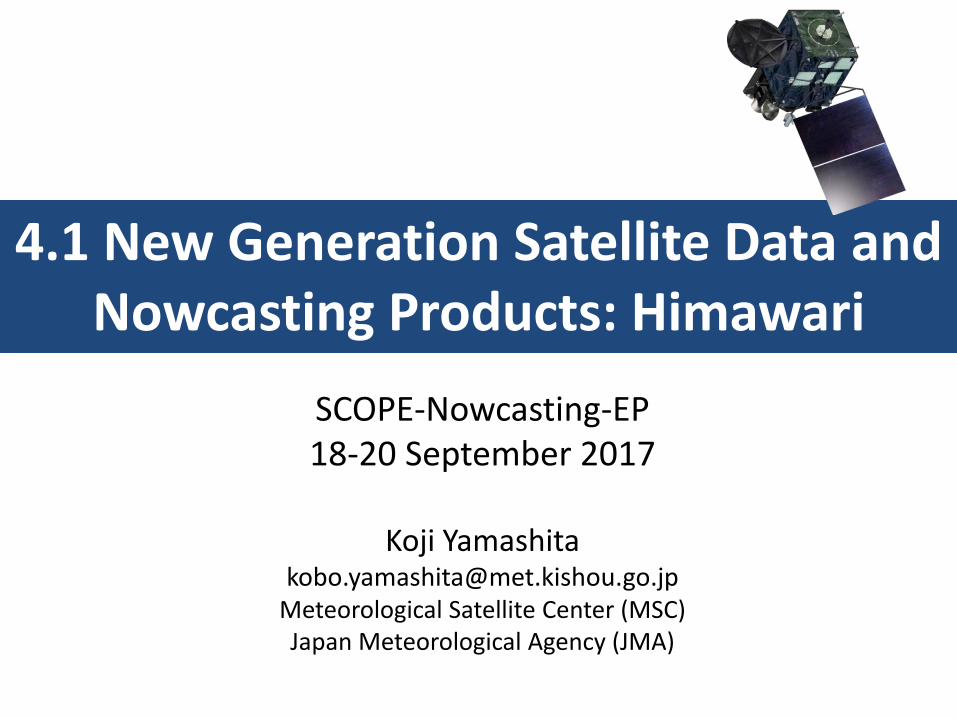
Successful Launch of Himawari-8
Himawari-8 was successfully launched using H-IIA Launch Vehicle # 25 on 7 October 2014 from the Tanegashima Space Center in Kagoshima, Japan
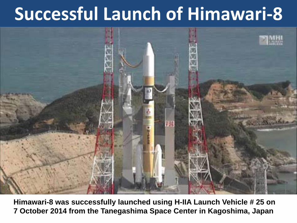
• Himawari-9 was successfully launched on 5th of Nov. 2016 • Himawari-9 is planned to start a backup-operation for Himawari-8 from next
March (2017)
Successful Launch of Himawari-9
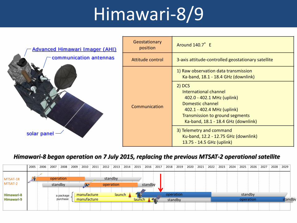
Himawari-8/9 Geostationary
position Around 140.7°E
Attitude control 3-axis attitude-controlled geostationary satellite
Communication
1) Raw observation data transmission Ka-band, 18.1 - 18.4 GHz (downlink)
2) DCS International channel 402.0 - 402.1 MHz (uplink) Domestic channel 402.1 - 402.4 MHz (uplink) Transmission to ground segments Ka-band, 18.1 - 18.4 GHz (downlink)
3) Telemetry and command Ku-band, 12.2 - 12.75 GHz (downlink) 13.75 - 14.5 GHz (uplink)
solar panel
communication antennas
Advanced Himawari Imager (AHI)
2005 2006 2007 2008 2009 2010 2011 2012 2013 2014 2015 2016 2017 2018 2019 2020 2021 2022 2023 2024 2025 2026 2027 2028 2029
MTSAT-1R MTSAT-2
Himawari-8 Himawari-9
standby
manufacture manufacture
a package purchase
launch standby launch
operation operation
operation standby operation standby
standby standby
Himawari-8 began operation on 7 July 2015, replacing the previous MTSAT-2 operational satellite
Spectral Bands
Band Spatial Resolution
Central Wavelength Physical Properties
1 Visible (VIS)
1 km 0.47 μm vegetation, aerosol
2 0.51 μm vegetation, aerosol
3 0.5 km 0.64 μm Vegetation, low cloud, fog
4 Near Infrared (NIR)
1 km 0.86 μm vegetation, aerosol
5 2 km
1.6 μm cloud phase/particle size
6 2.3 μm cloud particle size
7
Infrared (IR) 2 km
3.9 μm low cloud, fog, forest fire
8 6.2 μm upper-level moisture
9 6.9 μm mid- and upper-level moisture
10 7.3 μm mid-level moisture
11 8.6 μm cloud phase, SO2
12 9.6 μm Ozone content
13 10.4 μm cloud imagery, information of cloud top
14 11.2 μm cloud imagery, sea surface temperature
15 12.4 μm cloud imagery, sea surface temperature
16 13.3 μm cloud top height
cf. MTSAT-2
Bands
VIS 0.68 μm
IR4 3.7 μm
IR3 6.8 μm
IR1 10.8 μm
IR2 12.0 μm
Himawari-8/9 Imager (AHI; Advanced Himawari Imager)
3 Visible Bands
Addition of NIR Bands
Increase of WV Bands
Increase of TIR Bands
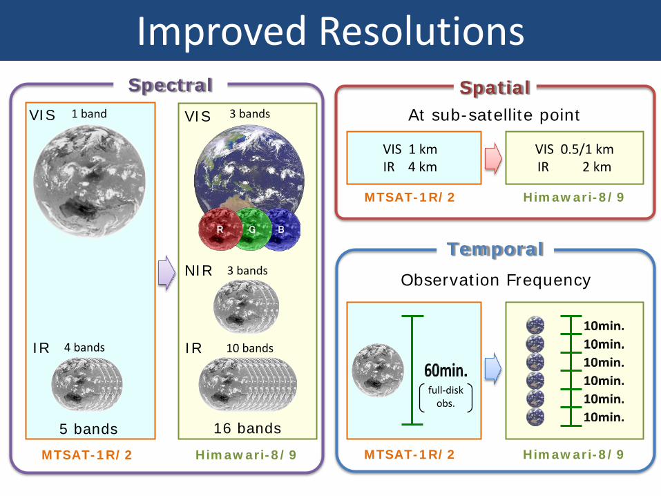
Improved Resolutions Spectral
G B R
5 bands 16 bands
10 bands
3 bands
3 bands
IR 4 bands
NIR
1 band VIS
MTSAT-1R/2 Himawari-8/9
VIS
IR
Temporal
MTSAT-1R/2 Himawari-8/9
full-disk obs.
Observation Frequency
VIS 1 km IR 4 km
VIS 0.5/1 km IR 2 km
Spatial At sub-satellite point
MTSAT-1R/2 Himawari-8/9
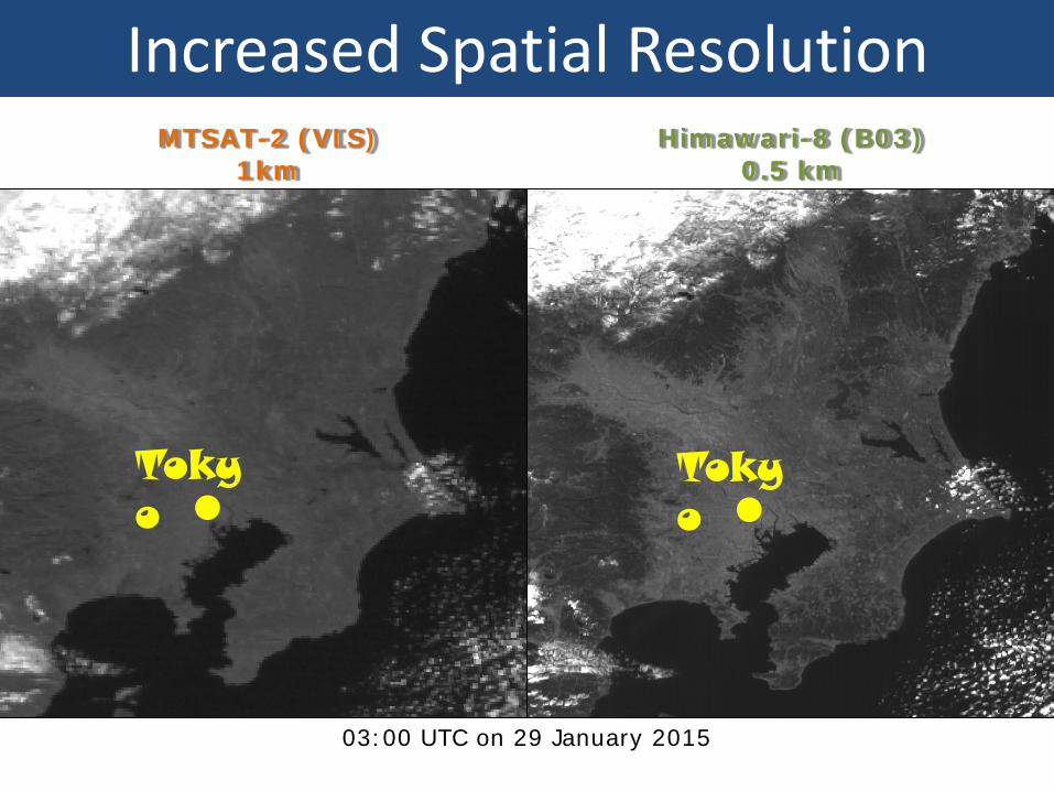
Increased Spatial Resolution MTSAT-2 (VIS)
1km Himawari-8 (B03)
0.5 km
03:00 UTC on 29 January 2015
Tokyo
Tokyo
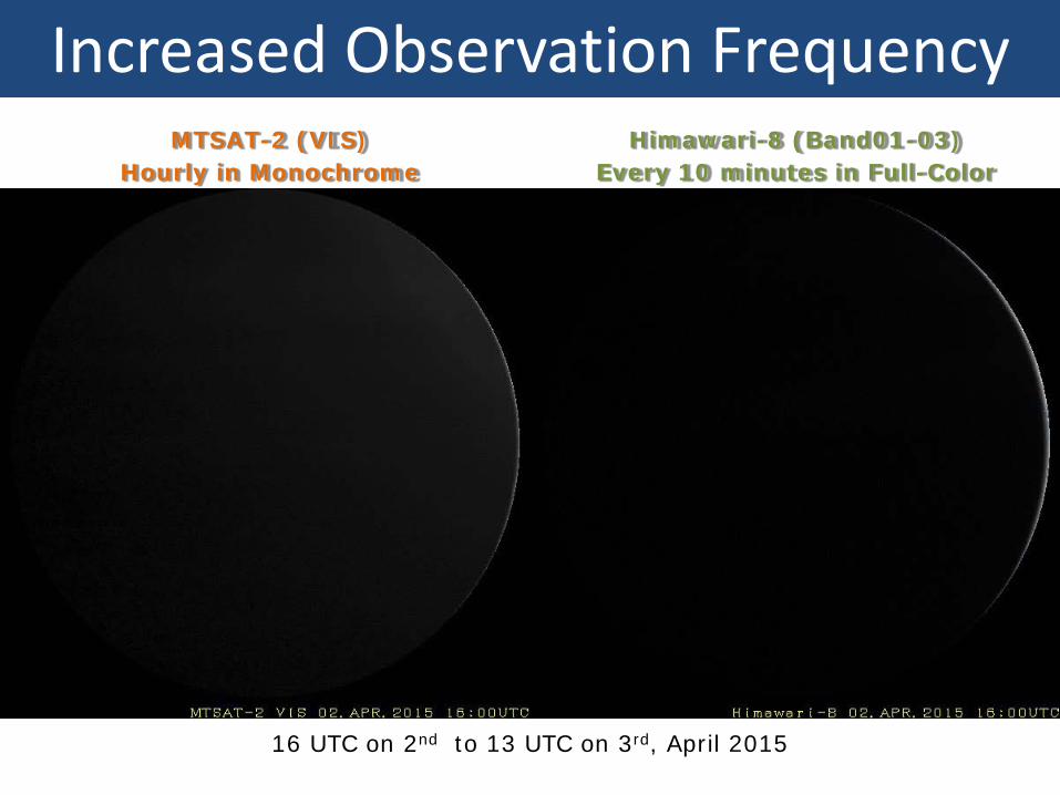
MTSAT-2 (VIS) Hourly in Monochrome
Himawari-8 (Band01-03) Every 10 minutes in Full-Color
16 UTC on 2nd to 13 UTC on 3rd, April 2015
Increased Observation Frequency
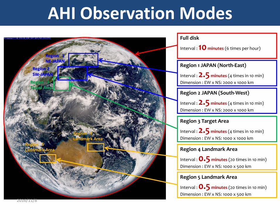
Region 2 SW-JAPAN
Region 1 NE-JAPAN
Region 4 Landmark Area
Region 5 Landmark Area
Region 3 Target Area
Full disk
Interval : 10 minutes (6 times per hour)
Region 3 Target Area
Interval : 2.5 minutes (4 times in 10 min) Dimension : EW x NS: 1000 x 1000 km
Region 2 JAPAN (South-West)
Interval : 2.5 minutes (4 times in 10 min) Dimension : EW x NS: 2000 x 1000 km
Region 1 JAPAN (North-East)
Interval : 2.5 minutes (4 times in 10 min) Dimension : EW x NS: 2000 x 1000 km
Region 4 Landmark Area
Interval : 0.5 minutes (20 times in 10 min) Dimension : EW x NS: 1000 x 500 km
Region 5 Landmark Area
Interval : 0.5 minutes (20 times in 10 min) Dimension : EW x NS: 1000 x 500 km
AHI Observation Modes
2016/11/8
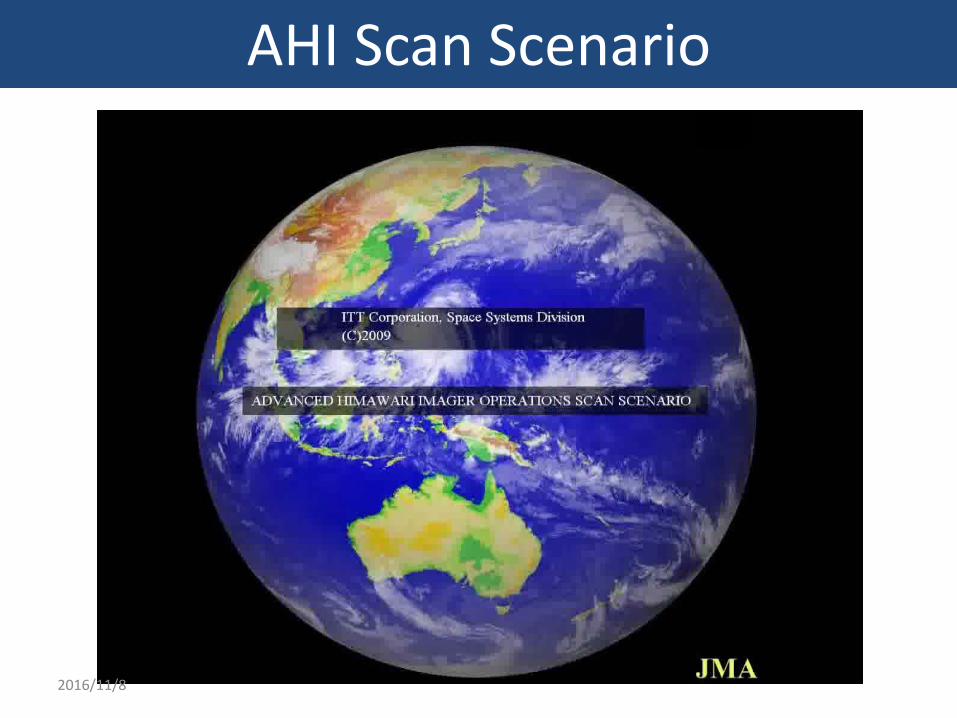
AHI Scan Scenario
2016/11/8
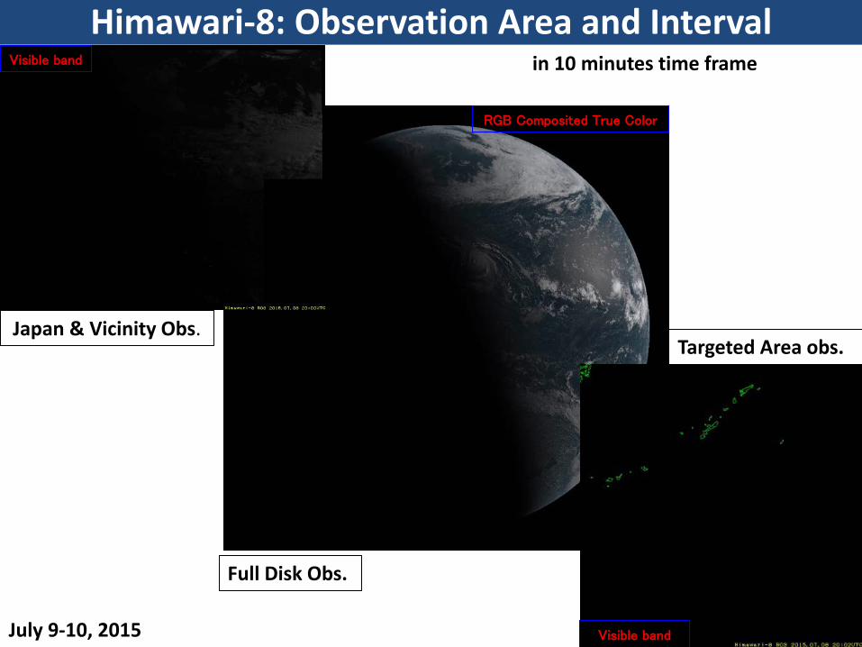
Visible band
Visible band
RGB Composited True Color
Japan & Vicinity Obs.
Full Disk Obs.
Targeted Area obs.
July 9-10, 2015
Himawari-8: Observation Area and Interval in 10 minutes time frame
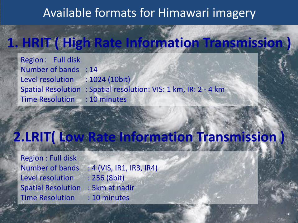
2.LRIT( Low Rate Information Transmission )
Region : Full disk Number of bands : 4 (VIS, IR1, IR3, IR4) Level resolution : 256 (8bit) Spatial Resolution : 5km at nadir Time Resolution : 10 minutes
Available formats for Himawari imagery
1. HRIT ( High Rate Information Transmission ) Region: Full disk Number of bands : 14 Level resolution : 1024 (10bit) Spatial Resolution : Spatial resolution: VIS: 1 km, IR: 2 - 4 km Time Resolution : 10 minutes
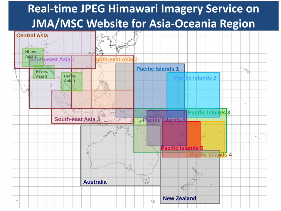
Pacific Islands 3
Pacific Islands 1 Pacific Islands 2
Pacific Islands 4 Pacific Islands 5
Pacific Islands 6 South-east Asia 3
Real-time JPEG Himawari Imagery Service on JMA/MSC Website for Asia-Oceania Region
15
South-east Asia 1 South-east Asia 2
Australia
New Zealand
Central Asia
Hi-res. Asia 2
Hi-res. Asia 3 Hi-res.
Asia 1
Pacific Islands 7
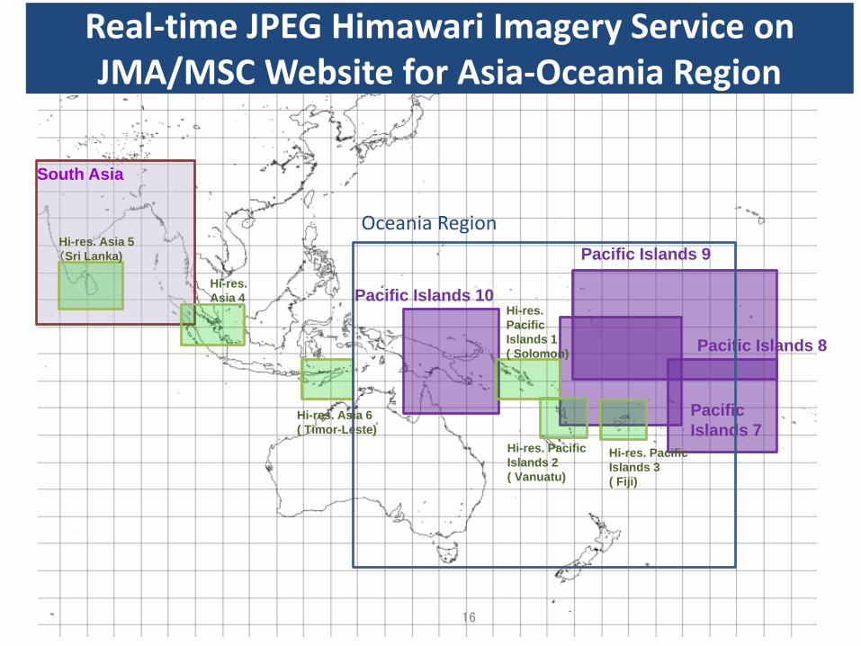
Real-time JPEG Himawari Imagery Service on JMA/MSC Website for Asia-Oceania Region
16
South Asia
Hi-res. Asia 6 ( Timor-Leste)
Hi-res. Asia 4
Hi-res. Asia 5 (Sri Lanka)
Pacific Islands 8
Pacific Islands 9
Pacific Islands 10
Hi-res. Pacific Islands 2 ( Vanuatu)
Hi-res. Pacific Islands 1 ( Solomon)
Hi-res. Pacific Islands 3 ( Fiji)
Oceania Region
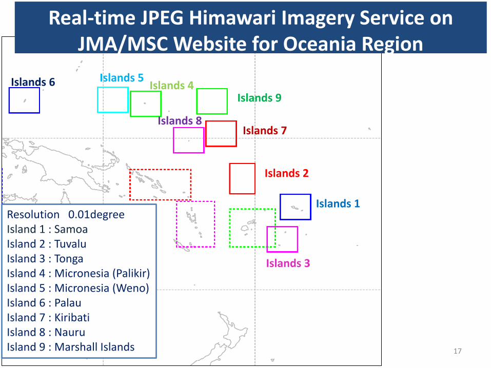
Islands 1
Islands 3
Islands 2
Islands 4 Islands 5 Islands 6
Islands 7 Islands 8
Islands 9
Resolution 0.01degree Island 1 : Samoa Island 2 : Tuvalu Island 3 : Tonga Island 4 : Micronesia (Palikir) Island 5 : Micronesia (Weno) Island 6 : Palau Island 7 : Kiribati Island 8 : Nauru Island 9 : Marshall Islands 17
Real-time JPEG Himawari Imagery Service on JMA/MSC Website for Oceania Region

Himawari-8 Products (NOWCASTING PRODUCT)
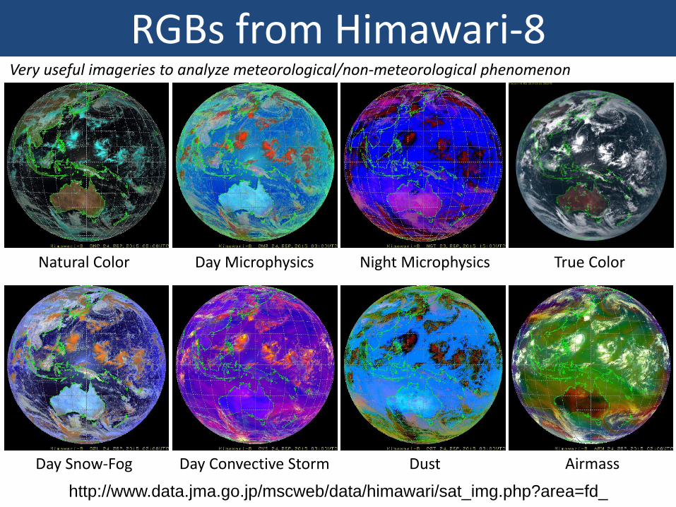
Natural Color Day Microphysics
Dust Airmass
Night Microphysics
Day Snow-Fog Day Convective Storm
True Color
http://www.data.jma.go.jp/mscweb/data/himawari/sat_img.php?area=fd_
RGBs from Himawari-8 Very useful imageries to analyze meteorological/non-meteorological phenomenon
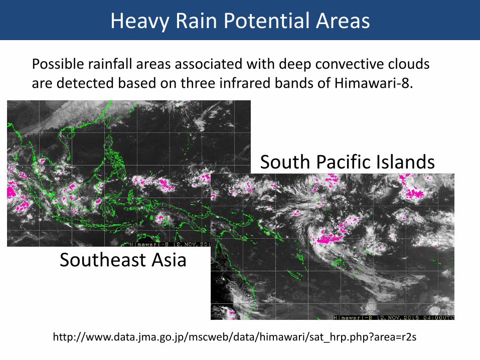
South Pacific Islands
Southeast Asia
http://www.data.jma.go.jp/mscweb/data/himawari/sat_hrp.php?area=r2s
Possible rainfall areas associated with deep convective clouds are detected based on three infrared bands of Himawari-8.
Heavy Rain Potential Areas
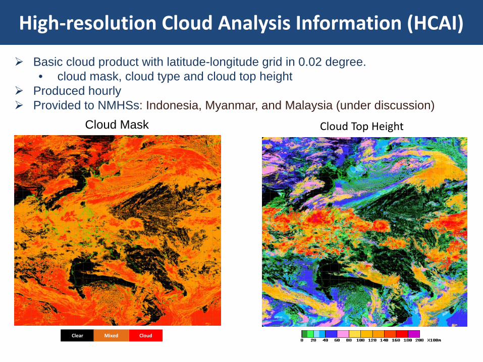
High-resolution Cloud Analysis Information (HCAI)
Basic cloud product with latitude-longitude grid in 0.02 degree. • cloud mask, cloud type and cloud top height
Produced hourly Provided to NMHSs: Indonesia, Myanmar, and Malaysia (under discussion)
Cloud Top Height
Clear Cloud Mixed
Cloud Mask
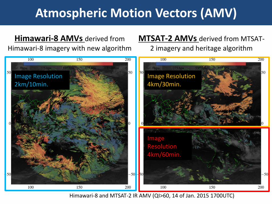
Atmospheric Motion Vectors (AMV)
Himawari-8 and MTSAT-2 IR AMV (QI>60, 14 of Jan. 2015 1700UTC)
Colder color : upper level wind warmer color : low level wind
Image Resolution 2km/10min.
Image Resolution 4km/30min.
Image Resolution 4km/60min.
Himawari-8 AMVs derived from Himawari-8 imagery with new algorithm
MTSAT-2 AMVs derived from MTSAT-2 imagery and heritage algorithm
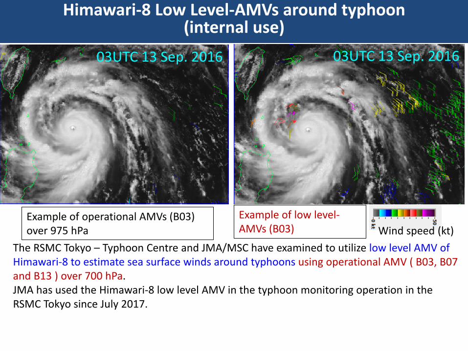
Himawari-8 Low Level-AMVs around typhoon (internal use)
The RSMC Tokyo – Typhoon Centre and JMA/MSC have examined to utilize low level AMV of Himawari-8 to estimate sea surface winds around typhoons using operational AMV ( B03, B07 and B13 ) over 700 hPa. JMA has used the Himawari-8 low level AMV in the typhoon monitoring operation in the RSMC Tokyo since July 2017.
Example of operational AMVs (B03) over 975 hPa
Example of low level-AMVs (B03) Wind speed (kt)
03UTC 13 Sep. 2016 03UTC 13 Sep. 2016
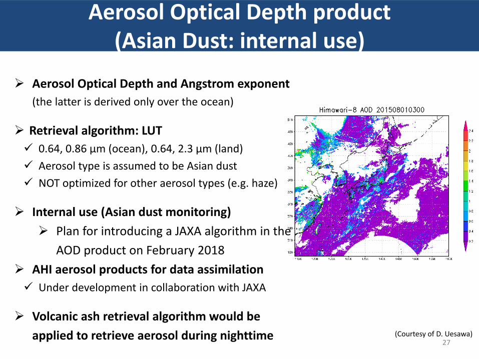
Aerosol Optical Depth product (Asian Dust: internal use)
27
Aerosol Optical Depth and Angstrom exponent (the latter is derived only over the ocean)
Retrieval algorithm: LUT 0.64, 0.86 μm (ocean), 0.64, 2.3 μm (land) Aerosol type is assumed to be Asian dust NOT optimized for other aerosol types (e.g. haze)
Internal use (Asian dust monitoring) Plan for introducing a JAXA algorithm in the
AOD product on February 2018 AHI aerosol products for data assimilation Under development in collaboration with JAXA
Volcanic ash retrieval algorithm would be applied to retrieve aerosol during nighttime (Courtesy of D. Uesawa)
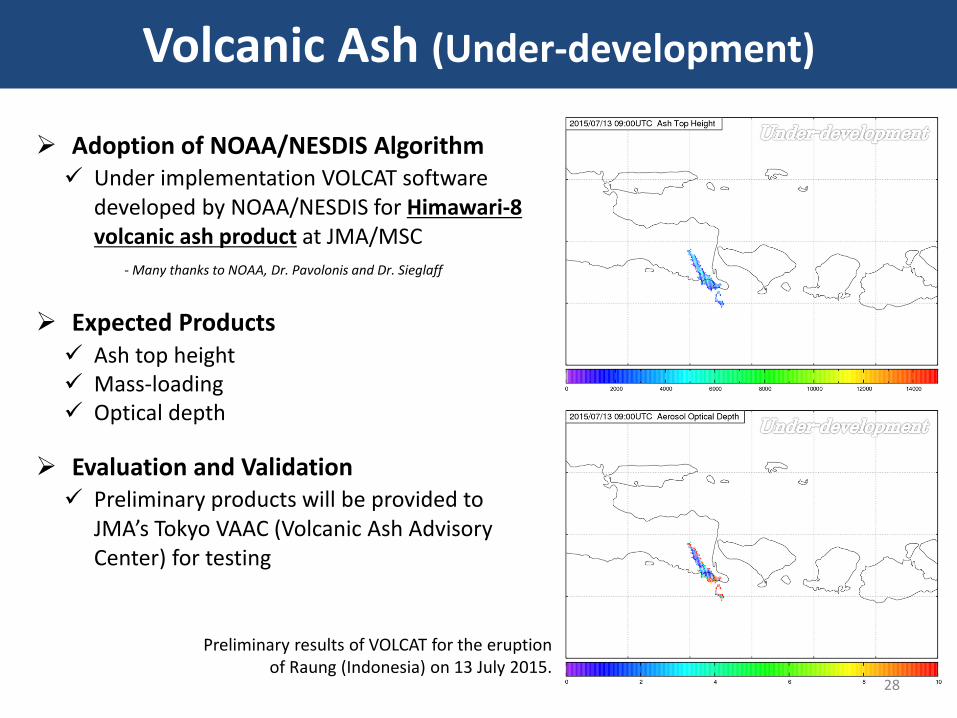
Volcanic Ash (Under-development)
28
Preliminary results of VOLCAT for the eruption of Raung (Indonesia) on 13 July 2015.
Adoption of NOAA/NESDIS Algorithm Under implementation VOLCAT software
developed by NOAA/NESDIS for Himawari-8 volcanic ash product at JMA/MSC
Expected Products Ash top height Mass-loading Optical depth
Evaluation and Validation Preliminary products will be provided to
JMA’s Tokyo VAAC (Volcanic Ash Advisory Center) for testing
- Many thanks to NOAA, Dr. Pavolonis and Dr. Sieglaff
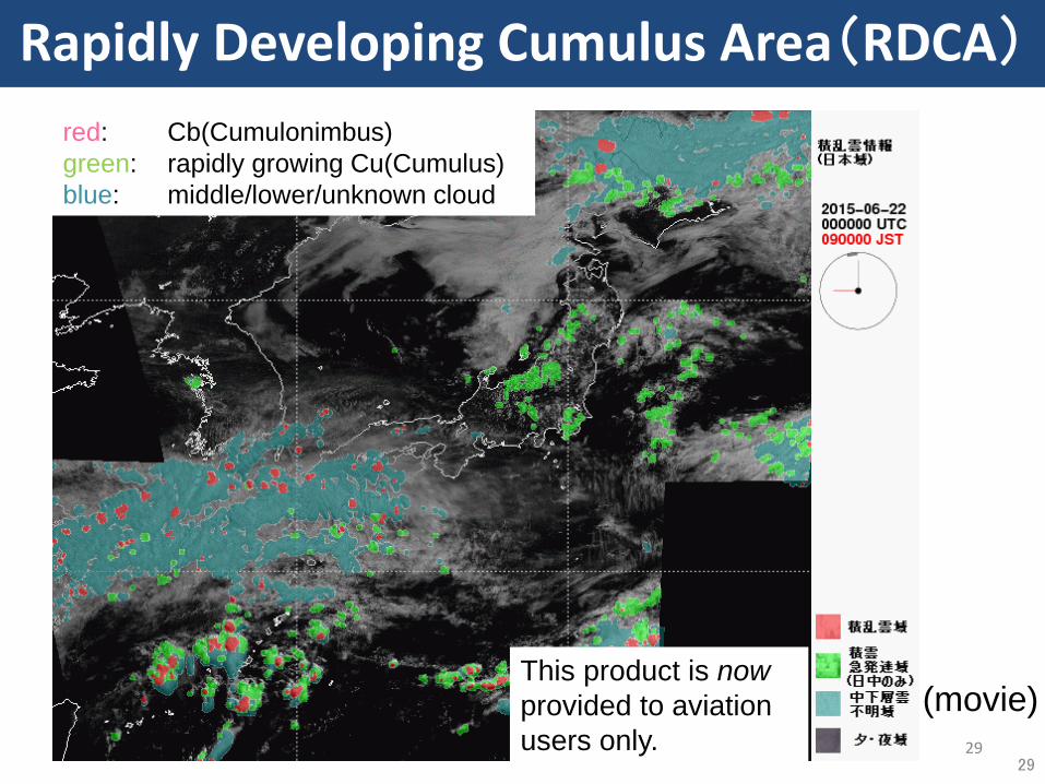
Rapidly Developing Cumulus Area(RDCA)
29
red: Cb(Cumulonimbus) green: rapidly growing Cu(Cumulus) blue: middle/lower/unknown cloud
This product is now provided to aviation users only. 29
(movie)
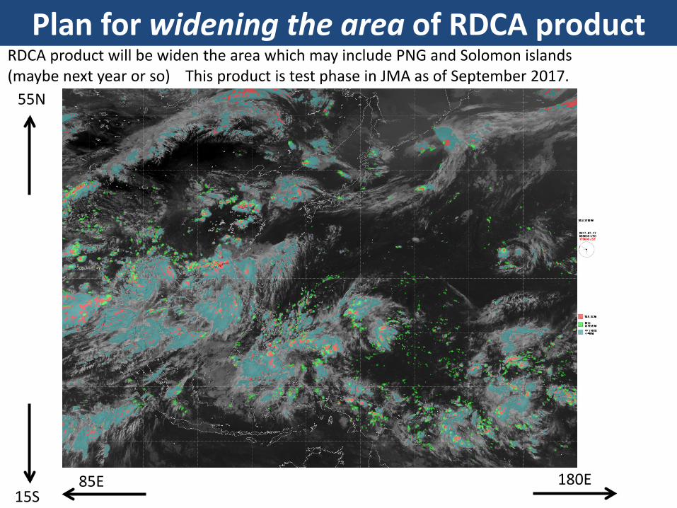
Plan for widening the area of RDCA product RDCA product will be widen the area which may include PNG and Solomon islands (maybe next year or so) This product is test phase in JMA as of September 2017.
15S 180E 85E
55N
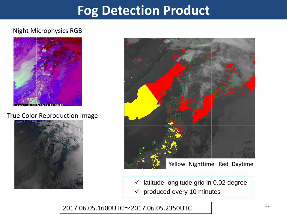
31 2017.06.05.1600UTC~2017.06.05.2350UTC
Night Microphysics RGB
True Color Reproduction Image
latitude-longitude grid in 0.02 degree produced every 10 minutes
Yellow:Nighttime Red:Daytime
Fog Detection Product
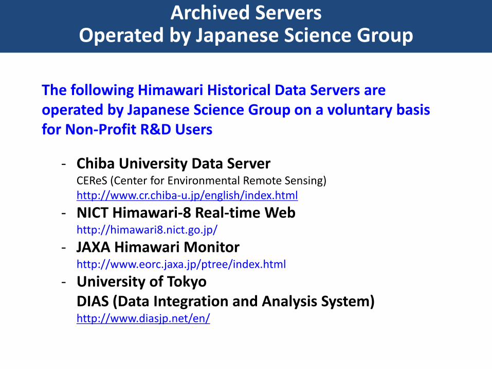
Archived Servers Operated by Japanese Science Group
The following Himawari Historical Data Servers are operated by Japanese Science Group on a voluntary basis for Non-Profit R&D Users
- Chiba University Data Server CEReS (Center for Environmental Remote Sensing) http://www.cr.chiba-u.jp/english/index.html
- NICT Himawari-8 Real-time Web http://himawari8.nict.go.jp/
- JAXA Himawari Monitor http://www.eorc.jaxa.jp/ptree/index.html
- University of Tokyo DIAS (Data Integration and Analysis System) http://www.diasjp.net/en/
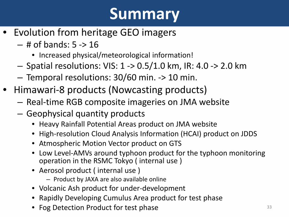
Summary • Evolution from heritage GEO imagers
– # of bands: 5 -> 16 • Increased physical/meteorological information!
– Spatial resolutions: VIS: 1 -> 0.5/1.0 km, IR: 4.0 -> 2.0 km – Temporal resolutions: 30/60 min. -> 10 min.
• Himawari-8 products (Nowcasting products) – Real-time RGB composite imageries on JMA website – Geophysical quantity products
• Heavy Rainfall Potential Areas product on JMA website • High-resolution Cloud Analysis Information (HCAI) product on JDDS • Atmospheric Motion Vector product on GTS • Low Level-AMVs around typhoon product for the typhoon monitoring
operation in the RSMC Tokyo ( internal use ) • Aerosol product ( internal use )
– Product by JAXA are also available online • Volcanic Ash product for under-development • Rapidly Developing Cumulus Area product for test phase • Fog Detection Product for test phase 33