Embed Size (px)
Citation preview

Canoga Transportation Corridor Project 4.10 Geology, Soils, and Seismicity Draft EIR
4.10-1
4.10 GEOLOGY, SOILS, AND SEISMICITY
Geology, soils, and seismicity are factors that often determine design criteria for the development of transit improvements, particularly when grade separation structures are involved. This section summarizes the geologic materials, faults, seismic characteristics, and other subsurface conditions of the project area. Impacts associated with the geotechnical considerations have been identified from a review of available published and unpublished literature that includes, but is not limited to, the safety elements of the general plans for the City and County of Los Angeles; official Alquist-Priolo earthquake fault zone maps; official seismic hazard zone maps; and geologic and topographic maps and other publications of California Geological Survey (CGS), United States Geological Survey (USGS), and the California Division of Oil and Gas.
4.10.1 EXISTING SETTING Regional Geologic Setting The proposed project is located within a western portion of the San Fernando Valley, which is an elongated valley, roughly 22 miles long in an east-west direction and generally approximately 9 miles wide in a north-south direction, although stretching to 12 miles wide at its widest point. Situated within the Transverse Ranges geomorphic province of California, the San Fernando Valley is bounded by the San Gabriel and Santa Susana Mountains to the north, the Santa Monica Mountains to the south, the Verdugo Mountains to the east, and the Simi Hills to the west. Geomorphic provinces are large natural regions, dominated by similar rocks or geologic structures. The Transverse Ranges geomorphic province is composed of several mountain ranges oriented in an east-west direction and extending over 320 miles from the Mojave and Colorado Desert Provinces to Point Arguello at the Pacific Ocean. Included within the Transverse Ranges are portions of Riverside, San Bernardino, Los Angeles, and Ventura Counties. Acting as a northern boundary, the Transverse Ranges truncate the northwest trending structural grain of the Peninsular Ranges geomorphic province, which is composed of multiple mountain ranges and valleys extending southward 775 miles past the US-Mexican Border. The Peninsular Ranges geomorphic province is the largest province in North America. Southern California is seismically active, being situated at the convergence of the North American and Pacific tectonic plates. Earthquakes along the San Andreas fault relieve convergent plate stress in the form of right lateral strike slip offsets. The Transverse Ranges work as a block causing the San Andreas fault to bend or kink, producing compressional stresses that are manifest as reverse, thrust, and right lateral faults. Faulting associated with the compressional forces creates earthquakes and is primarily responsible for the mountain building, basin development, and regional upwarping found in this area. As rocks are folded and faulted within the rising mountain ranges, landsliding and erosion transport sediment or alluvium into the San Fernando Valley, creating a deep sedimentary basin. Mountain ranges surrounding the San Fernando Valley contain rocks varying in age from the Pre-Cambrian eon to the Tertiary period and younger sedimentary and volcanic rocks that range from Tertiary period to Quaternary period. As ages of the rocks vary greatly, so does the composition of
Canoga Transportation Corridor Project 4.10 Geology, Soils, and Seismicity Draft EIR
4.10-2
the rocks surrounding the valley: from igneous and metamorphic crystalline complexes to marine and nonmarine sediments. Thus, the sediments within the San Fernando Valley vary greatly, both in composition and grain size. Topography, Slopes and Major Drainage The floor of the San Fernando Valley slopes gently to the east at about a one percent gradient. Elevations of the valley floor vary from 1,000 ft above mean sea level (MSL) at the north and northwestern ends of the valley, to 500 ft MSL at the Los Angeles River Narrows, the southeastern end of and point at which the Los Angeles River exits the valley. The Los Angeles River Narrows act as base level for the river and the valley. Sediments from the bounding mountain ranges are carried into and across the San Fernando Valley through numerous seasonal streams flowing to the Los Angeles River, the master drainage for the valley, which flows west to east. The Los Angeles River begins at the confluence of Arroyo Calabasas and Bell Creek, within the proposed project, approximately 1/4 mile west of Canoga Avenue, between Canoga Avenue and Topanga Canyon Boulevard, north of Vanowen Street. In this area, the Los Angeles River, Arroyo Calabasas, and Bell Creek are concrete lined channels. The Chatsworth Reservoir, now empty, was previously used by the Los Angeles Department of Water and Power (LADWP) as a water storage facility until 1969 when the dam was deemed to be unsafe in the event of a large earthquake, such as those subsequently experienced in 1971 and 1994. Currently, water flowing into the reservoir is directed through the outlet, which drains to Chatsworth Creek and into Bell Creek. The confluence of the creeks is located approximately 3/4 mile west of Topanga Boulevard. Chatsworth Reservoir is situated approximately 1/4 mile west of Topanga Canyon Boulevard. Beginning north of California State Route (SR) 118 is the south flowing Browns Canyon Wash, which is joined by the southeast flowing Santa Susana Pass Wash approximately 1/4-mile east of Canoga Avenue and 400 ft south of Parthenia Street. Both Browns Canyon and Santa Susana Washes are concrete lined within the project area. Browns Canyon Wash joins the Los Angeles River approximately 1 mile east of Canoga Street. Elevations within the proposed project area vary from approximately 950 ft MSL near the Chatsworth Metrolink Station to approximately 780 ft MSL at the southern end. Slope gradients generally range from less than one percent to one-half percent along the project reach. North of the Chatsworth Metrolink Station, the slope gradients are steeper with elevations rising to about 1,220 ft MSL near the intersection of Topanga Canyon Boulevard and the SR-118 in the foothills of the Santa Susana Mountains. Both cut and fill slopes are present along the northern portion of Topanga Canyon Boulevard. The average elevations of the mountains surrounding this portion of the San Fernando Valley range from 1,700 ft MSL for the Santa Monica Mountains, 1,800 ft MSL for the Simi Hills, to 2,000 ft for the Santa Susana Mountains. The highest point in the area is San Fernando Peak in the Santa Susana Mountains, having an elevation of 3,741 ft MSL.
Canoga Transportation Corridor Project 4.10 Geology, Soils, and Seismicity Draft EIR
4.10-3
Local Geology and Soils Holocene to Pleistocene alluvial and older elevated alluvial soils comprise the majority of geologic material exposed at the surface of the San Fernando Valley and within the proposed project area. Quaternary-age Saugus formation exposures are present northeast of the proposed project. The Tertiary Lindero Canyon and Monterey formations and the Cretaceous Chatsworth formation are exposed within the north and northwest portions of the proposed project area.1 Prior to construction of flood control dams and channels, the floor of the San Fernando Valley was composed of a series of coalescing alluvial fans with season streams shifting position throughout the valley. Alluvial sediments grade from coarse-grained sands and gravels at the eastern end of the valley, predominately carried into the valley from the crystalline complexes of the San Gabriel Mountains, to finer grained sediments at the western end of the valley, carried from the Tertiary and pre-Tertiary sedimentary formations surrounding this portion of the valley.2 Generally, the finer grained sediments of the west valley contain shallow and perched groundwater, as well as coarse-grained stream channel deposits. Lateral discontinuity of lithologies typifies the valley’s alluvium. Development throughout the project area has disturbed the majority of near-surface alluvial materials. Underlying the alluvial sediments of the western San Fernando Valley are Paleogene to Miocene sedimentary strata and Miocene Topanga and Modelo formations.3 These rocks extend and are exposed within the Santa Monica Mountains. Cretaceous-age rocks exposed within the Simi Hills are 2 km higher than similar strata under the western San Fernando Valley, being separated by the Chatsworth Reservoir fault. The depth of alluvium within the project area may vary from 100 to 700 ft below the ground surface (bgs). Available boring logs within and adjacent to project reach generally indicate the presence of loose to dense silty sands and stiff to hard silts with some clays and gravels underlain by very dense sands and gravels and very hard silts. Groundwater Groundwater data available from LADWP groundwater monitoring wells, boring logs in the project vicinity, and the historical high groundwater level presented in the CGS seismic hazard zone report were reviewed. LADWP identified nine groundwater monitoring wells throughout the project site and vicinity, four of which are currently inactive. Depths to groundwater within active wells varied from a minimum of 15.4 ft (Well No. 4719J located near Sherman Way and Brown Canyon Wash) to greater than 99 ft (Well No. 3600H located near Gault Street and Eton Avenue). Highest groundwater elevations were recorded in Well No. 4705A (874 ft MSL) located near the intersection of Canoga Avenue and Lassen
1 Dibblee, T.W., 1989, Geologic map of the Oat Mountain Quadrangle, Los Angeles County,
California, Map No. DF-22, Scale 1:24,000. 2 Tinsley, J.C., T.L. Youd, D.M. Perkins, and A.T.F. Chen, 1985, Evaluating Liquefaction Potential, In
Joseph I. Zioney, ed. Evaluating Earthquake Hazards in the Los Angeles Region – An Earth Science Perspective, U.S. Geological Survey, Professional Paper 1360, pp. 263-315.
3 Wright, T.L., 2001, Subsurface Geology of the San Fernando Valley, California, 97th Annual Meeting, and Pacific Section, American Association of Petroleum Geologists, April 9-11, 2001.
Canoga Transportation Corridor Project 4.10 Geology, Soils, and Seismicity Draft EIR
4.10-4
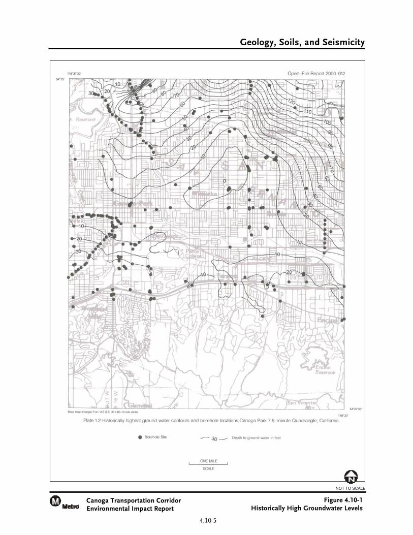
Street. The general groundwater gradient was to the south, with the lowest recorded elevation near the intersection of Galt Street and Eton Avenue in Well No. 3600H at 689 ft MSL. Although the gradient was generally to the south, it was not uniform. Additionally, LADWP reported groundwater monitoring Well No. 4735B approximately 1.4 miles east of the project area. A record of groundwater elevations was available from 1956 to 2006. In 1957, the highest groundwater level was recorded at a depth of 56.4 ft. Groundwater levels within the San Fernando Valley have been dropping since the 1960s. In 1996, the lowest groundwater level was recorded in Well No. 4735B at 86 ft bgs corresponding to an elevation of approximately 789 ft MSL. Groundwater levels were reportedly encountered at depths ranging from 25 to 40 ft in the boring logs reviewed. Historically high groundwater levels as depicted in the CGS seismic hazard zone report for the Canoga Park 7.5-minute quadrangle are presented on Figure 4.10-1. The historically high groundwater levels were as shallow as 10 ft bgs within the project reach, ranging from the south end of the project (Canoga Avenue and Victory Boulevard) to approximately Saticoy Street and near the Chatsworth Metrolink Station. Precipitation, runoff, and spreading of imported water are the primary means of recharge for the basin’s unconfined aquifer. Groundwater percolates into alluvial soils primarily through rivers (without concrete bottoms), near water retaining structures such as dams and flood control basins, and through spreading grounds. Seasonal precipitation and runoff are the only natural sources of recharge, and given that various types of development have covered the majority of the ground surface within the project area, recharge is limited. Historical rainfall records for the years 1985/86 through 2005/06 varied from 6 inches to approximately 43 inches per year with an average of 18.6 inches. During the 2005/06 year, 43 inches of precipitation fell on the valley, being the highest recorded rainfall total.4 Recharge basins are located within the eastern portion of the San Fernando Valley, down gradient from the project site. Portions of three MWD water supply feeders are located within the site: West Valley Feeder No. 1, West Valley Feeder No. 2, and the Calabasas Feeder. West Valley Feeders No. 1 and No. 2 transect the proposed project near its northern boundary, south of SR-118. The Calabasas Feeder ties to West Valley Feeder No. 2, extending southward along Topanga Canyon Boulevard past the Chatsworth Reservoir where it bends to the west of site before continuing further to the south. As the groundwater basin is an unconfined aquifer, the depth of the basin extends from the ground surface to approximately 1,200 ft bgs; although, within the project area, the depth is estimated to vary from approximately 100 to 700 ft bgs. While groundwater levels have generally dropped since the 1960s, levels vary both seasonally and annually, and are dominated by groundwater basin management through pumping by DWP. Given these conditions, there is potential for continued shallow groundwater throughout the site.
4 Metropolitan Water District, 2007, web page http://www.mwdh2o.com.
Geology, Soils, and Seismicity
Canoga Transportation Corridor Environmental Impact Report
Figure 4.10-1 Historically High Groundwater Levels
4.10-5
NOT TO SCALE
Canoga Transportation Corridor Project 4.10 Geology, Soils, and Seismicity Draft EIR
4.10-6
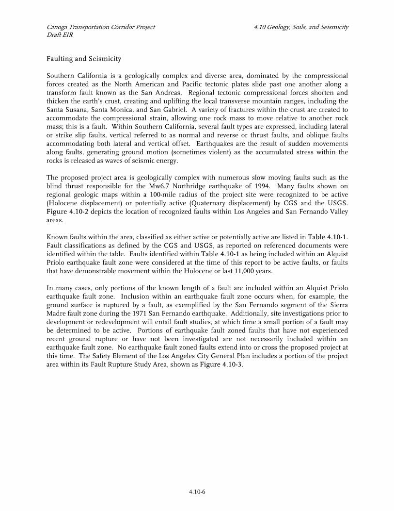
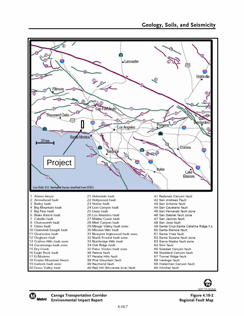
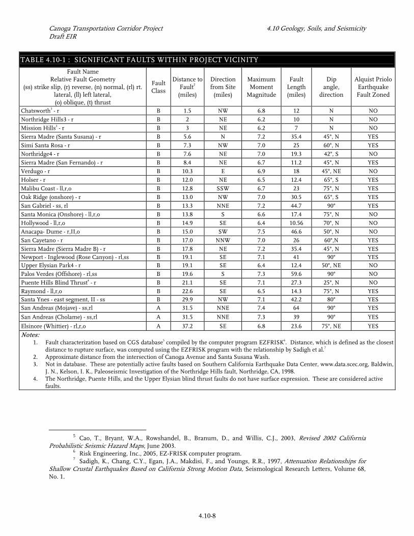
Faulting and Seismicity Southern California is a geologically complex and diverse area, dominated by the compressional forces created as the North American and Pacific tectonic plates slide past one another along a transform fault known as the San Andreas. Regional tectonic compressional forces shorten and thicken the earth’s crust, creating and uplifting the local transverse mountain ranges, including the Santa Susana, Santa Monica, and San Gabriel. A variety of fractures within the crust are created to accommodate the compressional strain, allowing one rock mass to move relative to another rock mass; this is a fault. Within Southern California, several fault types are expressed, including lateral or strike slip faults, vertical referred to as normal and reverse or thrust faults, and oblique faults accommodating both lateral and vertical offset. Earthquakes are the result of sudden movements along faults, generating ground motion (sometimes violent) as the accumulated stress within the rocks is released as waves of seismic energy. The proposed project area is geologically complex with numerous slow moving faults such as the blind thrust responsible for the Mw6.7 Northridge earthquake of 1994. Many faults shown on regional geologic maps within a 100-mile radius of the project site were recognized to be active (Holocene displacement) or potentially active (Quaternary displacement) by CGS and the USGS. Figure 4.10-2 depicts the location of recognized faults within Los Angeles and San Fernando Valley areas. Known faults within the area, classified as either active or potentially active are listed in Table 4.10-1. Fault classifications as defined by the CGS and USGS, as reported on referenced documents were identified within the table. Faults identified within Table 4.10-1 as being included within an Alquist Priolo earthquake fault zone were considered at the time of this report to be active faults, or faults that have demonstrable movement within the Holocene or last 11,000 years. In many cases, only portions of the known length of a fault are included within an Alquist Priolo earthquake fault zone. Inclusion within an earthquake fault zone occurs when, for example, the ground surface is ruptured by a fault, as exemplified by the San Fernando segment of the Sierra Madre fault zone during the 1971 San Fernando earthquake. Additionally, site investigations prior to development or redevelopment will entail fault studies, at which time a small portion of a fault may be determined to be active. Portions of earthquake fault zoned faults that have not experienced recent ground rupture or have not been investigated are not necessarily included within an earthquake fault zone. No earthquake fault zoned faults extend into or cross the proposed project at this time. The Safety Element of the Los Angeles City General Plan includes a portion of the project area within its Fault Rupture Study Area, shown as Figure 4.10-3.
Geology, Soils, and Seismicity
Canoga Transportation Corridor Environmental Impact Report
Figure 4.10-2 Regional Fault Map
4-10.7
NOT TO SCALE
Project
Canoga Transportation Corridor Project 4.10 Geology, Soils, and Seismicity Draft EIR
4.10-8
TABLE 4.10-1 : SIGNIFICANT FAULTS WITHIN PROJECT VICINITY Fault Name
Relative Fault Geometry (ss) strike slip, (r) reverse, (n) normal, (rl) rt.
lateral, (ll) left lateral, (o) oblique, (t) thrust
Fault Class
Distance toFault2
(miles)
Direction from Site
(miles)
Maximum Moment
Magnitude
Fault Length (miles)
Dip angle,
direction
Alquist Priolo Earthquake Fault Zoned
Chatsworth3 - r B 1.5 NW 6.8 12 N NO
Northridge Hills3 - r B 2 NE 6.2 10 N NO
Mission Hills3 - r B 3 NE 6.2 7 N NO
Sierra Madre (Santa Susana) - r B 5.6 N 7.2 35.4 45°, N YES
Simi Santa Rosa - r B 7.3 NW 7.0 25 60°, N YES
Northridge4 - r B 7.6 NE 7.0 19.3 42°, S NO
Sierra Madre (San Fernando) - r B 8.4 NE 6.7 11.2 45°, N YES
Verdugo - r B 10.3 E 6.9 18 45°, NE NO
Holser - r B 12.0 NE 6.5 12.4 65°, S YES
Malibu Coast - ll,r,o B 12.8 SSW 6.7 23 75°, N YES
Oak Ridge (onshore) - r B 13.0 NW 7.0 30.5 65°, S YES
San Gabriel - ss, rl B 13.3 NNE 7.2 44.7 90° YES
Santa Monica (Onshore) - ll,r,o B 13.8 S 6.6 17.4 75°, N NO
Hollywood - ll,r,o B 14.9 SE 6.4 10.56 70°, N NO
Anacapa- Dume - r,II,o B 15.0 SW 7.5 46.6 50°, N NO
San Cayetano - r B 17.0 NNW 7.0 26 60°,N YES
Sierra Madre (Sierra Madre B) - r B 17.8 NE 7.2 35.4 45°, N YES Newport - Inglewood (Rose Canyon) - rl,ss B 19.1 SE 7.1 41 90° YES Upper Elysian Park4 - r B 19.1 SE 6.4 12.4 50°, NE NO
Palos Verdes (Offshore) - rl,ss B 19.6 S 7.3 59.6 90° NO
Puente Hills Blind Thrust4 - r B 21.1 SE 7.1 27.3 25°, N NO
Raymond - ll,r,o B 22.6 SE 6.5 14.3 75°, N YES Santa Ynes - east segment, II - ss B 29.9 NW 7.1 42.2 80° YES San Andreas (Mojave) - ss,rl A 31.5 NNE 7.4 64 90° YES
San Andreas (Cholame) - ss,rl A 31.5 NNE 7.3 39 90° YES
Elsinore (Whittier) - rl,r,o A 37.2 SE 6.8 23.6 75°, NE YES
Notes: 1. Fault characterization based on CGS database5 compiled by the computer program EZFRISK6. Distance, which is defined as the closest
distance to rupture surface, was computed using the EZFRISK program with the relationship by Sadigh et al.7 2. Approximate distance from the intersection of Canoga Avenue and Santa Susana Wash. 3. Not in database. These are potentially active faults based on Southern California Earthquake Data Center, www.data.scec.org, Baldwin,
J. N., Kelson, I. K., Paleoseismic Investigation of the Northridge Hills fault, Northridge, CA, 1998. 4. The Northridge, Puente Hills, and the Upper Elysian blind thrust faults do not have surface expression. These are considered active
faults.
5 Cao, T., Bryant, W.A., Rowshandel, B., Branum, D., and Willis, C.J., 2003, Revised 2002 California
Probabilistic Seismic Hazard Maps, June 2003. 6 Risk Engineering, Inc., 2005, EZ-FRISK computer program. 7 Sadigh, K., Chang, C.Y., Egan, J.A., Makdisi, F., and Youngs, R.R., 1997, Attenuation Relationships for
Shallow Crustal Earthquakes Based on California Strong Motion Data, Seismological Research Letters, Volume 68, No. 1.
Geology, Soils, and Seismicity
Canoga Transportation Corridor Environmental Impact Report
Figure 4.10-3 Fault Rupture Study Area
City of Los Angeles, Safety Element
4.10-9
Scale in miles
Project
Fault Rupture Study Area – City of Los Angeles
NOT TO SCALE
Canoga Transportation Corridor Project 4.10 Geology, Soils, and Seismicity Draft EIR
4.10-10
Several faults are present in Southern California that do not have surface expression. These faults are generally known as blind thrust faults. Both the Whittier Narrows earthquake (1987) and the Northridge earthquake (1994) occurred on blind thrust faults. Blind thrust faults are low angle reverse faults that do not extend to the surface; therefore, identifying their locations from surface mapping is difficult at best. Rather deep bore holes and seismic records provide details about the geometry of these faults. Underlying the proposed project area is the Northridge Thrust, which is sometimes called the Pico Thrust, as it is known for its creation of the Pico Anticline. Movement on the Northridge Thrust resulted in the 1994 Northridge earthquake. This fault is thought to be part of the Oak Ridge fault, situated west of the site, extending offshore where it is known to be seismically active. As the trace of the Oak Ridge fault is followed toward the proposed project area, it is obscured and is overlain by the Santa Susana fault, thereby creating a blind thrust in the area of the project. Strong Ground Motion Ground shaking intensity is influenced by several factors, including but not limited to the distance of the epicenter from the site and depth at which the earthquake occurred, the magnitude of the earthquake, subsurface geologic structures, as well as surface topography, depth of groundwater, and strength of the earth materials underlying the site. An earthquake’s intensity is the affect the ground shaking has on the earth’s surface. Several methods for rating earthquakes have been developed, but within the United States, the Modified Mercalli Intensity (MMI) is used. This system is not mathematically derived, but is simply based on observation of destruction, indexed to the roman numerals I through XII, with an “I” representing an event that was nearly unperceivable, to “XII,” which represents near total destruction of all structures and the land surface is deformed. Measurements of ground motion or magnitudes of the amount of energy released by an earthquake are quantified and recorded on various scales, the first of which was originally developed by Charles F. Richter in 1935. The scales are based on a logarithm of the amplitude of waves recorded by seismographs. Several scales have been developed, but most commonly used are the Richter magnitude or local magnitude (ML), the surface-wave magnitude (Ms), the body wave magnitude (Mb), and the moment magnitude (Mw). Currently, the moment magnitude is most commonly reported, as it is based on the concept of seismic moment and is the most accurate scale for large magnitude earthquakes. Earthquake-induced ground motion intensity can be described using peak site accelerations, represented as a fraction of the acceleration of gravity (g). Peak bedrock accelerations for design level earthquakes on a nearby fault can be calculated using any of a number of different attenuation relationships. Given the proximity of the proposed project area with respect to the faults listed within Table 4.10-1 and shown on Figure 4.10-2, in conjunction with known damage associated with both the 1971 San Fernando Earthquake (6.7 Mw), and the 1994 Northridge earthquake (6.7 Mw) intense ground shaking should be expected in the future with force sufficient to produce a X or XI on the MMI. The strongest ground acceleration ever measured instrumentally within an urban area of North America

Canoga Transportation Corridor Project 4.10 Geology, Soils, and Seismicity Draft EIR
4.10-11
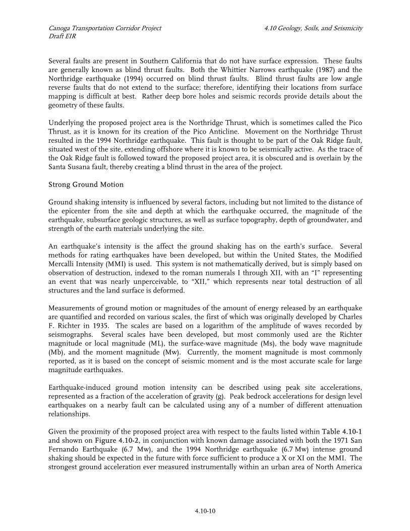
(Southern California Earthquake Center [SCEC]) was measured during the Northridge earthquake to be 1.8g, recorded on Tarzan Hill, some 1.5 miles from the site.8 Probabilistic analyses performed using the computer program EZFRISK indicate that the peak ground motion can vary from 0.35g to 0.42g and 0.64g to 0.84g for Operating Design Earthquake (ODE) and Maximum Design Earthquake (MDE; ODE and MDE defined in Section 4.10.2) events, respectively.9 Liquefaction and Related Ground Failures Liquefaction occurs when saturated, low relative density, low plastic materials are transformed from a solid to a near-liquid state. This phenomenon occurs when moderate to severe seismic ground shaking causes pore-water pressure to increase. Site susceptibility to liquefaction is a function of the depth, density, soil type, and water content of granular sediments, along with the magnitude and frequency of earthquakes in the surrounding region. Saturated, unconsolidated silts, sands, and silty sands within 50 ft of the ground surface are most susceptible to liquefaction. Liquefaction-related phenomena include lateral spreading, ground oscillation, flow failures, loss of bearing strength, subsidence, and buoyancy effects.10 The expected level of ground shaking in the proposed project area is high enough to initiate liquefaction. This in conjunction with known shallow groundwater (less than 50 ft bgs) and the presence of loose to medium dense sands, silty sands, and stiff silts provide for susceptibly to liquefaction within portions of the proposed project area. A seismic hazard zone map, produced by the State of California is presented as Figure 4.10-4.11 This map indicates that more than 50 percent of the proposed project area is susceptible to liquefaction. Areas that are designated as potential liquefaction zones have or have had a water table shallower than 40 ft bgs. Soils with a potential for liquefaction are shown to be concentrated within the southern half of the proposed project area in part due to the Los Angeles River with its young sediments and near surface groundwater. Los Angeles City Safety Elements maps depict approximately 50 percent of the proposed project area to be within areas of potential liquefaction, Figure 4.10-5. Delineated liquefaction areas are not coincident with those of the State of California Seismic Hazard Maps. Differences may be the result of the data sets used and the water depths used as screening criteria. City of Los Angeles maps delineate two zones: Liquefiable Areas (groundwater 30 ft or less bgs) and Potential Liquefiable Area (groundwater between 30 ft and 50 ft bgs). It should be noted that the City of Los Angeles Bureau of Engineering, Department of Public Works has adopted the liquefaction boundaries shown on the State of California Seismic Hazard Maps.
8 Shakal, A., M. Huang, R. Darragh, T. Cao R. Sherburne, P. Malhotra, C. Cramer, R. Sydnor, V.
Graizer, G. Maldonado, C. Peterspm, and J. Wampole, 1994, CSMIP Strong Motion Records from the Northridge, California, Earthquake of 17 January 1994, report OSMS 94-07, California Division of Mines and Geology, Sacramento, California.
9 Risk Engineering, Inc., 2005, EZ-FRISK computer program. 10 Youd, T.L. and Perkins, D M., 1978, Mapping Liquefaction-Induced Ground Failure Potential,
Proceedings of the American Society of Civil Engineers, Journal of the Geotechnical Engineering Division, v. 104, no. GT4, pp. 433-446.
11 California Geological Survey, 2001, Alquist-Priolo Earthquake Fault Zone (APEFZ) maps, Geographic Information System (GIS) data files.

Geology, Soils, and Seismicity
Canoga Transportation Corridor Environmental Impact Report
Figure 4.10-4 Seismic Hazards Map
4.10-12
NOT TO SCALE
Geology, Soils, and Seismicity
Canoga Transportation Corridor Environmental Impact Report
Figure 4.10-5 Susceptibility to Liquefaction
City of Los Angeles, Safety Element
4.10-13
Project
City of Los Angeles – Department of City Planning Safety Element of the Los Angeles City General Plan
NOT TO SCALE
Canoga Transportation Corridor Project 4.10 Geology, Soils, and Seismicity Draft EIR
4.10-14
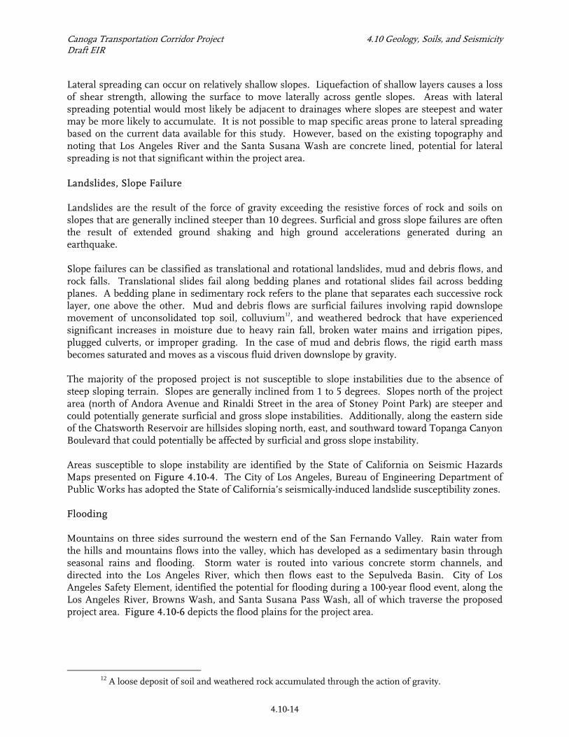
Lateral spreading can occur on relatively shallow slopes. Liquefaction of shallow layers causes a loss of shear strength, allowing the surface to move laterally across gentle slopes. Areas with lateral spreading potential would most likely be adjacent to drainages where slopes are steepest and water may be more likely to accumulate. It is not possible to map specific areas prone to lateral spreading based on the current data available for this study. However, based on the existing topography and noting that Los Angeles River and the Santa Susana Wash are concrete lined, potential for lateral spreading is not that significant within the project area. Landslides, Slope Failure Landslides are the result of the force of gravity exceeding the resistive forces of rock and soils on slopes that are generally inclined steeper than 10 degrees. Surficial and gross slope failures are often the result of extended ground shaking and high ground accelerations generated during an earthquake. Slope failures can be classified as translational and rotational landslides, mud and debris flows, and rock falls. Translational slides fail along bedding planes and rotational slides fail across bedding planes. A bedding plane in sedimentary rock refers to the plane that separates each successive rock layer, one above the other. Mud and debris flows are surficial failures involving rapid downslope movement of unconsolidated top soil, colluvium12, and weathered bedrock that have experienced significant increases in moisture due to heavy rain fall, broken water mains and irrigation pipes, plugged culverts, or improper grading. In the case of mud and debris flows, the rigid earth mass becomes saturated and moves as a viscous fluid driven downslope by gravity. The majority of the proposed project is not susceptible to slope instabilities due to the absence of steep sloping terrain. Slopes are generally inclined from 1 to 5 degrees. Slopes north of the project area (north of Andora Avenue and Rinaldi Street in the area of Stoney Point Park) are steeper and could potentially generate surficial and gross slope instabilities. Additionally, along the eastern side of the Chatsworth Reservoir are hillsides sloping north, east, and southward toward Topanga Canyon Boulevard that could potentially be affected by surficial and gross slope instability. Areas susceptible to slope instability are identified by the State of California on Seismic Hazards Maps presented on Figure 4.10-4. The City of Los Angeles, Bureau of Engineering Department of Public Works has adopted the State of California’s seismically-induced landslide susceptibility zones. Flooding Mountains on three sides surround the western end of the San Fernando Valley. Rain water from the hills and mountains flows into the valley, which has developed as a sedimentary basin through seasonal rains and flooding. Storm water is routed into various concrete storm channels, and directed into the Los Angeles River, which then flows east to the Sepulveda Basin. City of Los Angeles Safety Element, identified the potential for flooding during a 100-year flood event, along the Los Angeles River, Browns Wash, and Santa Susana Pass Wash, all of which traverse the proposed project area. Figure 4.10-6 depicts the flood plains for the project area.
12 A loose deposit of soil and weathered rock accumulated through the action of gravity.
Geology, Soils, and Seismicity
Canoga Transportation Corridor Environmental Impact Report
Figure 4.10-6 100 and 500 Year Flood
City of Los Angeles, Safety Element 4.10-15
Project
Scale in miles
NOT TO SCALE
Canoga Transportation Corridor Project 4.10 Geology, Soils, and Seismicity Draft EIR
4.10-16
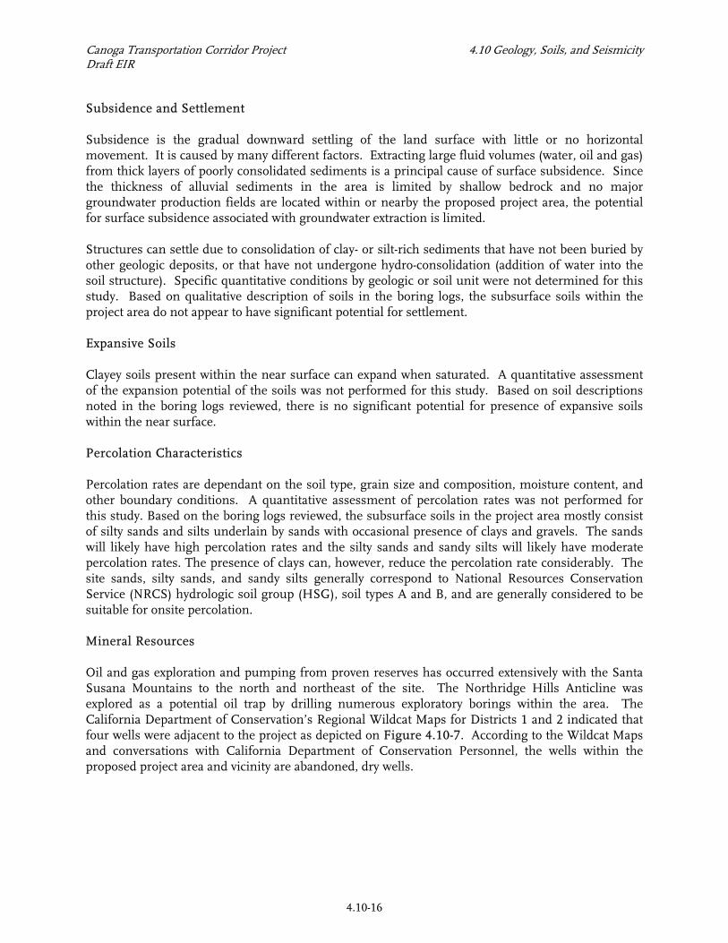
Subsidence and Settlement Subsidence is the gradual downward settling of the land surface with little or no horizontal movement. It is caused by many different factors. Extracting large fluid volumes (water, oil and gas) from thick layers of poorly consolidated sediments is a principal cause of surface subsidence. Since the thickness of alluvial sediments in the area is limited by shallow bedrock and no major groundwater production fields are located within or nearby the proposed project area, the potential for surface subsidence associated with groundwater extraction is limited. Structures can settle due to consolidation of clay- or silt-rich sediments that have not been buried by other geologic deposits, or that have not undergone hydro-consolidation (addition of water into the soil structure). Specific quantitative conditions by geologic or soil unit were not determined for this study. Based on qualitative description of soils in the boring logs, the subsurface soils within the project area do not appear to have significant potential for settlement. Expansive Soils Clayey soils present within the near surface can expand when saturated. A quantitative assessment of the expansion potential of the soils was not performed for this study. Based on soil descriptions noted in the boring logs reviewed, there is no significant potential for presence of expansive soils within the near surface. Percolation Characteristics Percolation rates are dependant on the soil type, grain size and composition, moisture content, and other boundary conditions. A quantitative assessment of percolation rates was not performed for this study. Based on the boring logs reviewed, the subsurface soils in the project area mostly consist of silty sands and silts underlain by sands with occasional presence of clays and gravels. The sands will likely have high percolation rates and the silty sands and sandy silts will likely have moderate percolation rates. The presence of clays can, however, reduce the percolation rate considerably. The site sands, silty sands, and sandy silts generally correspond to National Resources Conservation Service (NRCS) hydrologic soil group (HSG), soil types A and B, and are generally considered to be suitable for onsite percolation. Mineral Resources Oil and gas exploration and pumping from proven reserves has occurred extensively with the Santa Susana Mountains to the north and northeast of the site. The Northridge Hills Anticline was explored as a potential oil trap by drilling numerous exploratory borings within the area. The California Department of Conservation’s Regional Wildcat Maps for Districts 1 and 2 indicated that four wells were adjacent to the project as depicted on Figure 4.10-7. According to the Wildcat Maps and conversations with California Department of Conservation Personnel, the wells within the proposed project area and vicinity are abandoned, dry wells.
Geology, Soils, and Seismicity
Canoga Transportation Corridor Environmental Impact Report
Figure 4.10-7 Location of Oil and Gas Wells
4.10-17
Project Area
NOT TO SCALE
Canoga Transportation Corridor Project 4.10 Geology, Soils, and Seismicity Draft EIR
4.10-18
4.10.2 REGULATORY FRAMEWORK The Alquist-Priolo Geologic Hazards Zone Act was passed in 1972 by the State of California to mitigate the hazard of surface faulting to structures for human occupancy. The Act has been amended 10 times and was renamed the Alquist-Priolo Earthquake Fault Zoning Act on January 1, 1994. The Alquist-Priolo Earthquake Fault Zoning Act’s main purpose is to prevent the construction of structures used for human occupancy on the surface trace of active faults as documented in Special Publication 42 by CGS. The Act only addresses the hazard of surface fault rupture and is not directed toward other earthquake hazards. The Seismic Hazards Mapping Act of 1990 was enacted, in part, to address seismic hazards not included in the Alquist-Priolo Act, including strong ground shaking, landslides, and liquefaction. Under this Act, the State Geologist is assigned the responsibility of identifying and mapping seismic hazards. CGS Special Publication 117, adopted in 1997 by the State Mining and Geology Board, constitutes guidelines for evaluating seismic hazards other than surface faulting, and for recommending mitigation measures as required by Public Resources Code Section 2695 (a). In accordance with the mapping criteria, the CGS seismic hazard zone maps use a ground shaking event that corresponds to 10 percent probability of exceedance in 50 years. Metro Design Criteria requires that special earthquake protection criteria be followed for important structures such as the grade separation bridges.13 “The guiding philosophy of earthquake design for the Metro Rail projects is to provide a high level of assurance that the overall system will continue to operate during and after an Operating Design Earthquake (ODE).” Operating procedures assume safe shut down and inspection before returning to operation. “Further, the system design will provide a high level of assurance that public safety will be maintained during and after a Maximum Design Earthquake (MDE).” The ODE and MDE are defined as earthquake events with return periods of 200 and 2,500 years, respectively.13 The probabilities of exceedance of the ODE and MDE events are 40 and 5 percent or less, respectively, during the 100-year facility design life. 4.10.3 IMPACTS AND MITIGATION MEASURES Significance Criteria The criteria used to determine the significance of an impact are based on Appendix G of the CEQA Guidelines. The project impacts related to geology and soils would be considered significant if the project could:
• Expose people or structures to potential substantial adverse effects, including the risk of loss, injury, or death involving: − Rupture of a known earthquake fault − Strong seismic ground shaking − Seismic-related ground failure including liquefaction − Landslides
• Result in substantial soil erosion or the loss of topsoil.
13 Metro, 2005, Los Angeles County Metropolitan Transportation Authority Design Criteria for Mid-
City Exposition LRT.
Canoga Transportation Corridor Project 4.10 Geology, Soils, and Seismicity Draft EIR
4.10-19
• Be located on a geologic unit or soil that is unstable, or that would become unstable as a result of the project, and potentially result in on- or off-site landslide, lateral spreading, subsidence, or collapse.
• Be located on expansive soil. • Has soils incapable of adequately supporting the use of septic tanks or alternative waste water
disposal systems where sewers are not available for the disposal of waste water. Methodology Based on review of available data noted in Section 4.10.1, existing conditions in the proposed project area were evaluated in accordance with the Impact Criteria listed above. Impacts considered are indicated below. Specific Mitigation Measures are provided for impacts that are considered potentially significant. Impact 4.10.1. The proposed project could expose people or structures to less than significant to potentially significant adverse effects from surface rupture of an earthquake fault prior to mitigation. The project site is not located within an Alquist-Priolo earthquake fault zone. A portion of the site is, however, located within a fault rupture study zone as shown on Figure 4.10-3. Surface rupture could also occur at the project site when movement occurs at known active faults such as Sierra Madre fault zone (located approximately 10 miles from the site) or along potentially active faults such as Chatsworth fault (located approximately 1.5 miles from the site) or previously unknown faults. Alternative 1. No Project The No Project alternative would not result in any change in impacts related to rupture of an earthquake. Alternative 2. TSM Improvements would consist of new bus stops with canopies for the new local transit line for Canoga Avenue. Since these structures are lightly loaded and because the site is not located within an Alquist-Priolo zone the adverse exposure from these improvements are less than significant. Alternative 3. Canoga On-Street Dedicated Bus Lanes Improvements would consist of widening of Canoga Avenue within Metro ROW, landscaping, bikeway/pedestrian path, walls, and bus stations with canopy. Since the proposed structures would be lightly loaded (except the widening of the existing bridge over the Los Angeles River) and because the site is not located within an Alquist-Priolo zone the adverse exposure from these improvements would be less than significant. Alternative 4. Canoga Busway Improvements would consist of addition of two bus lanes within Metro ROW, landscaping, bikeway/pedestrian path, drainage swales, bus stations with canopy, widening/ replacement of grade separation structures where Canoga Avenue crosses the Los Angeles River and Santa Susana Wash, a potential new grade separation structure at Lassen Street/Metrolink railroads, and soundwalls. All
Canoga Transportation Corridor Project 4.10 Geology, Soils, and Seismicity Draft EIR
4.10-20
improvements except the proposed grade separation structures would be lightly loaded and because the site is not located within an Alquist-Priolo zone the adverse exposure from these improvements would be less than significant. The potential grade separation structure near Lassen Street is located within a fault rupture study zone as shown on Figure 4.10-3. If further studies indicate that there is a potential for fault rupture in this area then the proposed grade separation structure could be subjected to potentially significant adverse effects without mitigation. Mitigation Measures: No mitigation required for Alternatives 1, 2, and 3. For Alternative 4 Mitigation measure MM 4.10-1 should be performed.
MM 4.10-1: A geological study shall be performed during the final design of any proposed grade separation structures located within the fault study area shown on Figure 4.10-3. The results of the geological studies shall be incorporated in the final design of the structure.
Level of Impact After Mitigation: Less than significant.
________________ Impact 4.10.2 The proposed project could expose people or structures to significant adverse effects from strong seismic ground shaking. The project site, similar to any other site in Southern California, would be subjected to strong ground shaking during a seismic event. The anticipated ground acceleration for design seismic events ranges from 0.35 g to 0.84g as indicated in Section 4.10.1. Alternative 1. No Project The No Project alternative would not result in any change in impacts related to strong seismic ground shaking. Alternative 2. TSM The proposed bus stops and canopies would be subjected to strong seismic ground shaking and could pose a hazard to project workers and riders without proper design. Alternative 3. Canoga On-Street Dedicated Bus Lanes The proposed bus stops, canopies, grade separation structures, and walls would be subjected to strong seismic ground shaking and without mitigation could pose significant risks to workers, riders, and passers by.
Canoga Transportation Corridor Project 4.10 Geology, Soils, and Seismicity Draft EIR
4.10-21
Alternative 4. Canoga Bus Way The proposed bus stops, canopies, soundwalls, and grade separation structures would be subjected to strong seismic ground shaking and without mitigation could pose significant risks to workers, riders, and passers by. Mitigation Measures: No mitigation is required for Alternative 1. Mitigation measures MM 4.10-2 and MM 4.10-3 identified below shall be required for Alternatives 2, 3, and 4.
MM 4.10-2: A geotechnical investigation shall be performed during final design. The investigation shall include collection of site specific soil samples, laboratory testing, engineering analyses, and recommendations for final design. MM4.10-3: During the investigation noted in MM4.10-2, the magnitude of the strong ground shaking shall be confirmed and acceleration response spectra recommended for design seismic events in accordance with the latest editions of Metro, AREMA, Caltrans code, and California Building codes. The structural design shall then incorporate these shaking in accordance with the applicable codes to maintain structural integrity during seismic events.
Level of Impact After Mitigation: Less than significant.
____________________ Impact 4.10.3 The proposed project could expose people or structures to potentially significant adverse effects from liquefaction-induced ground failures prior to mitigation. More than 50 percent of the site is located within a liquefaction zone as shown on Figure 4.10-4 and discussed within Section 4.10.1. While the proposed project would not increase the site liquefaction potential a collapse failure of the proposed structures could adversely affect life safety. Alternative 1. No Project The No Project alternative would not result in any change in impacts related to liquefaction induced ground failure. Alternative 2. TSM The proposed bus stops and canopies on Canoga Avenue at Sherman Way, Roscoe Boulevard, and Lassen Street are within the liquefaction zone. The foundations for the proposed bus stops and canopies would likely be located within the upper 5 to 10 ft. The current ground water levels are generally deeper than 20 ft bgs at these locations. The effects of liquefaction would, therefore, be likely increased settlement at these improvements and not a total collapse. Accordingly, the impact is expected to be less than significant for the lightly loaded structures planned for this alternative.
Canoga Transportation Corridor Project 4.10 Geology, Soils, and Seismicity Draft EIR
4.10-22
Alternative 3. Canoga On-Street Dedicated Bus lanes The proposed bus stops and canopies on Canoga Avenue at Sherman Way, Saticoy, Roscoe Boulevard, and Lassen Street and the grade separation structure at Los Angeles River structure are within the liquefaction zone. The grade separation structure (widening) would be founded on large shallow foundations or deep pile foundations. These foundations can be significantly affected by liquefaction. Alternative 4. Canoga Busway In addition to the bus stops and canopies similar to that noted for Alternatives 2 and 3, the grade separation structure at the Los Angeles River and the potential grade separation near Lassen Street are located within the liquefaction zone. The grade separation structures would be founded on large shallow foundations or deep pile foundations. These foundations can be significantly affected by liquefaction. Mitigation Measures: A range of mitigation measures will be applicable based on the extent of liquefaction potential and structure foundation loads and depths. No mitigation is required for Alternative 1. Alternative 2 would require MM 4.10-2, MM 4.10-4, and if needed MM 4.10-5. Alternatives 3 and 4 would require MM 4.10-2, MM 4.10-4, and if needed MM 4.10-5 and MM 4.10-6.
MM 4.10-4: The geotechnical investigation noted in MM 4.10-2 shall include evaluation of site specific liquefaction potential in accordance with CGS Special Publication 117 for all planned structures that lie within the liquefaction zone shown on Figure 4.10-4.
MM 4.10-5: For lightly loaded structures such as bus stops, canopies, and walls, if MM 4.10-4 indicates that the likely effect of liquefaction is increased settlement and not collapse, then incorporate geotechnical and/or structural methods to mitigate the effects of liquefaction on the foundations during final design. The geotechnical mitigation methods may range from recompaction of the upper material to provision of a mechanically stabilized earth (MSE) foundation system. The structural mitigation methods may range from planning for repairs/ maintenance after a seismic event to supporting the improvements on mat foundation or interconnected beam foundations to tolerate the anticipated seismic settlement without collapse. MM 4.10-6: For grade separation structures, if MM 4.10-4 indicates liquefaction potential, then incorporate structural design to mitigate effects of liquefaction or perform geotechnical ground improvement to mitigate liquefaction potential. The structural design will likely include deep pile foundations that extend below the potentially liquefiable layers. The foundation design should incorporate the effects of liquefaction induced down drag on axial pile capacity and reduced lateral resistance from liquefied soils per geotechnical recommendations. The ground improvement methods may range from stone columns in non-contaminated areas to compaction grouting in contaminated areas.
Canoga Transportation Corridor Project 4.10 Geology, Soils, and Seismicity Draft EIR
4.10-23
Level of Impact After Mitigation: Less than significant
__________________ Impact 4.10.4 The proposed project would expose people or structures to less than significant adverse effects from landslides; no mitigation is required, although mitigation is recommended. The project site is located outside a landslide hazard zone. No steep slopes were observed within the project area and no significant fill slopes are proposed. Permanent slopes will be required at the grade separation locations. Alternative 1. No Project The No Project alternative would have no impact from landslides. Alternative 2. TSM Alternative 2 would have no impact from landslides. Alternative 3. Canoga On-Street Dedicated Bus lanes Alternative 3 would require permanent slopes at the abutments of the grade separation structure at Los Angeles River. The abutment slopes at the Los Angeles River could have a potential for slope instability during a seismic event because of the high seismic ground shaking and liquefaction potential. Alternative 4. Canoga Busway Alternative 4 would require permanent slopes at the abutments of the grade separation structures. The abutment slopes at the Los Angeles River and the potential abutment slopes near Lassen Street could have a potential for slope instability during a seismic event because of the high seismic ground shaking and liquefaction potential. Mitigation Measures: No mitigation is required for Alternatives 1 and 2. For Alternatives 3 and 4, mitigation measures MM 4.10-2 and MM 4.10-7 are recommended to reduce instability of new slopes during seismic conditions.
MM 4.10-7: Perform slope stability analyses for the planned abutment slopes at the grade separation structures at Los Angeles River and Lassen Street considering seismic ground shaking and liquefaction potential. If analyses indicate a factor-of-safety (FS) less than 1.1 for pseudo-static conditions or FS less than 1.3 for post-earthquake conditions, deformation analyses should be performed and its effects on the foundations should be evaluated. If the foundations cannot tolerate the estimated deformations, the slope inclinations will have to be revised (to be shallower) such that the minimum FS values noted above are met.
Canoga Transportation Corridor Project 4.10 Geology, Soils, and Seismicity Draft EIR
4.10-24
Level of Impact After Mitigation: Less than significant to no impact.
____________________ Impact 4.10.5 The proposed project is not expected to result in significant erosion or loss of top soil; no mitigation is required. Mitigation Measures: The surface at the project site would be paved or vegetated. Accordingly, no mitigation measure is required for Alternatives 1 through 4. Level of Impact After Mitigation: Less than significant to no impact.
________________________ Impact 4.10.6 The proposed project would have less than significant potential to result in on- or off-site landslide, lateral spreading, and collapse; no mitigation is required. The proposed project is not located on a geologic unit or soil that is unstable, or that could become unstable as a result of the project. However, there is significant potential for liquefaction and liquefaction induced subsidence as noted in Impact 4.10-3. Mitigation Measures: No mitigation measure is required for Alternatives 1 through 4 except as noted for Impact 4.10.3. The geotechnical investigation noted in MM 4.10-2 should confirm the absence of unstable geologic unit or soil along the proposed improvements. Level of Impact After Mitigation: Less than significant.
____________________ Impact 4.10.7 The proposed project would have less than significant potential for adverse effects from expansive soils; no mitigation is required. Based on the soil descriptions noted on the boring logs reviewed, the upper soils primarily consist of sands and silts and expansive soils are not present along the project alignment. Clays that have expansion potential may, however, be localized. Mitigation Measures: The geotechnical investigation noted in MM 4.10-2 should confirm the absence of expansion soils along improvements that may be affected by expansive soils. Level of Impact After Mitigation: Less than significant.
Canoga Transportation Corridor Project 4.10 Geology, Soils, and Seismicity Draft EIR
4.10-25
____________________ Impact 4.10.8 The soils at the proposed project site can adequately support septic tanks and an alternative waste water system, if needed; no mitigation is required. The soils in the proposed project area already support septic tanks and a large infrastructure of sewer pipes. Any small additional demand for any septic tanks generated by Project restrooms or auxiliary facilities could be accommodated by existing infrastructure. Mitigation Measures: None required. Level of Impact After Mitigation: Less than significant.
____________________ Impact 4.10.9 The proposed project would have less than significant impact from other subsurface conditions such as shallow subsurface gas; no mitigation is required. There are no known methane or hydrogen sulfide deposits within the project area. No major construction of enclosed spaces such as buildings and subterranean parking structures is associated with the project; therefore, there is no potential for the accumulation of shallow subsurface gas to impact the proposed project area. Mitigation Measures: None required. Level of Impact After Mitigation: Less than significant.
____________________ Impact 4.10.10 The proposed project would have less than significant impacts on geologic resources during construction; no mitigation is required, although measures are recommended. Alternative 1. No Project Under the No project Alternative, existing conditions would remain the same and no construction will be performed. Therefore there is no construction period impact. Alternative 2. TSM Alternative 2 involves construction of bus stops and canopies only. Since these improvements are not extensive and consist of minimal localized site grading the construction period impact for Alternative 2 will be less than significant.
Canoga Transportation Corridor Project 4.10 Geology, Soils, and Seismicity Draft EIR
4.10-26
Alternative 3. Canoga On-Street Dedicated Bus lanes Alternative 3 will require roadway and wall construction in addition to the bus stops and canopies. Grading could also be required for the proposed widening of grade separation structures. Roadway construction could expose soils along the proposed alignment to possible wind and water erosion. Existing groundwater levels were at more than 20 ft bgs. Groundwater should therefore not impact the construction of most of the proposed improvements with the exception of widening of grade separations. Four documented abandoned oil wells or dry holes are identified adjacent to the proposed project area and none of these are within the Alternative 3 alignment. If undocumented abandoned oil wells or dry holes are encountered during grading activities a significant or adverse impact would result. See Section 4.11 for potential for encountering hazardous or contaminated materials. Alternative 4. Canoga Busway Alternative 4 would require construction of grade separation structure near Lassen Street in additions to the improvements noted for Alternative 3. The construction period impacts for Alternative 4 would therefore include those noted for Alternative 3 as well as additional concerns of handling groundwater for the Lassen Street grade separation. Mitigation Measures: No mitigation measures are required for Alternative 1. Mitigation measures are recommended for Alternatives 2, 3, and 4 in accordance with general construction procedures. Mitigation measures MM4.10-8 and MM 4.10-9 are applicable for Alternative 2. For Alternatives 3 and 4, MM 4.10-8 through MM 4.10-10 are applicable. See section 4.11 for mitigation measures if hazardous or contaminated materials are encountered during construction.
MM 4.10-8: Implementing industry standard storm water pollution control Best Management Practices would reduce soil erosion to a less than significant or adverse level. Erosion control measures that shall be implemented as part of Best Management Practices would include the placement of sandbags, use of proper grading techniques, appropriate sloping, and covering or stabilizing topsoil stockpiles. Construction industry standard storm water Best Management Practices are provided in the State of California Storm Water Best Management Practice Handbook, Construction Activity. MM 4.10-9: Discoveries of undocumented wells or dry holes during construction activities must be reported to the City of Los Angeles and the California Division of Oil, Gas and Geothermal Resources (DOGGR). Any wells or dry holes uncovered must be plugged and abandoned in accordance with current DOGGR regulations. MM 4.10-10: Any groundwater that is encountered during foundation installation (or during excavations for the underpass option near Lassen Street) should be contained and disposed off-site appropriately.
Level of Impact After Mitigation: Less than significant.
____________________
Canoga Transportation Corridor Project 4.10 Geology, Soils, and Seismicity Draft EIR
4.10-27
Impact 4.10.11. There is no potential for substantial cumulative geologic resource impacts because potential geologic impacts are mostly localized; no mitigation is required. Mitigation Measures: None required. Level of Impact After Mitigation: Less than significant.
_______________________________