Embed Size (px)
Citation preview
Pre-Disaster Mitigation Plan Flathead County, Montana
4.3 FLOODING
Description and History
CPRI SCORE = 2.85
A flood is a natural event for rivers and streams. Excess water from snowmelt and rainfall accumulates
and overflows onto the banks and adjacent floodplains. Floodplains are lowlands, adjacent to rivers and
lakes that are subject to recurring floods. A flash flood generally results from a torrential (short duration)
rain or cloudburst on a relatively small drainage area. Ice jam flooding occurs when pieces of floating ice
carried by the streams current accumulate at an obstruction to the stream. The water held back can
cause flooding upstream, and if the obstruction suddenly breaks, flash flooding can then occur
downstream as well. A log jam is an accumulation of large woody debris (usually logs more than four
inches in diameter and over six feet long) that can span an entire stream or river channel. When the jam
is large enough water can accumulate upstream of the jam which will cause flooding. Once a log jam
releases, downstream flooding may occur. The Flathead, Stillwater and Whitefish Rivers all have had
significant log jams in the past and it can be assumed they will occur again in the future.
It is estimated that flooding causes 90 percent of all property losses from natural disasters in the United
States and kill an average of 150 people a year nationwide. Most injuries and deaths occur when people
are swept away by flood currents and most property damage results from inundation by sediment-laden
water. Faster moving floodwater can wash buildings off their foundations and sweep vehicles
downstream. Pipelines, bridges, and other infrastructure can be damaged when high water combines
with flood debris. Basement flooding can cause extensive damage to the structure and systems of a
building.
The NWS provides short-term forecasts and warnings of hazardous weather to the public by producing
regularly-scheduled severe weather outlooks and updates on various forms of hazardous weather
including heavy rain and flooding. A “watch” is issued when conditions are favorable for severe weather
in or near the watch area. A “warning” is issued when the severe weather event is imminent or occurring
in the warned area. Warning and Advisory Criteria for flooding is presented below.
Flash Flood Warning: Flooding is imminent, water levels rise rapidly with inundation occurring in less
than 6 hours.
Flood Warning: Flooding is expected to occur more than 6 hours after the causative event.
The most severe flooding in Flathead County usually occurs in the spring and early summer months as a
result of snowmelt and/or rainfall runoff. On rare occasions, ice jams result in some overbank flooding. In
addition to flooding along streams, shallow flooding periodically occurs in other isolated, developed
areas of the county due to other factors. The mountains can receive several hundred inches of snow
annually. Low flows in the basin occur naturally during the winter months, and floods normally occur in
Tetra Tech Inc. 4-29 September 2014
Pre-Disaster Mitigation Plan Flathead County, Montana
the spring during periods of rapid snowmelt. Runoff from snowmelt, occasionally combined with rainfall,
provides high stream flows in the spring.
According to the Flathead County Growth Policy (2012), the Flathead Valley has experienced six severe
flood events. These occurred in 1894, 1926, 1948, 1964, 1975 and 1995. Presidential Disasters due to
flooding were declared in Flathead County in 1975, 1996, 1997, and 2011. Statewide flood emergencies
were declared in 1978, 1981, 1984, 1986, 1997, 1998, 2003 and 2013 (DMA, 2013).
A description of several flood events in Flathead County from the Flathead County Flood Insurance Study
(FEMA, 2013) is presented below.
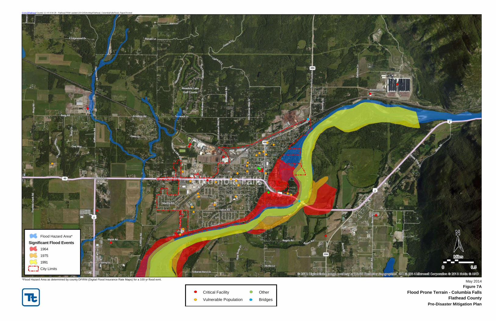
1964 Flood - Rain-swollen Bear Creek swept down from the Continental Divide to obliterate large
sections of U.S. Highway 2. What once was a timbered valley along Bear Creek was now a wide gravel
and rock trough (Hungry Horse News). Extremely high runoff in the Middle Fork Flathead River drainage
basin caused extensive damage to highways and railroads in narrow valleys along the southern edge of
Glacier National Park. A steel bridge on U.S. Highway 2 across the river at the unincorporated community
of Essex was washed away. In the Nyack Flats area downstream of Essex, 30 residents were evacuated by
air. It was reported that one of the homes and some barns at Nyack had only roofs above water. Farther
downstream along Middle Fork Flathead River at West Glacier, the main highway bridge to the west
entrance of Glacier National Park was damaged beyond repair. An old, low single arch concrete bridge
was completely submerged, but the arch was not seriously damaged. Downstream from West Glacier, a
rock canyon constricted flow, and for a time, part of the river flowed upstream along McDonald Creek
into Lake McDonald in Glacier National Park. Flow of South Fork Flathead River was completely regulated
at Hungry Horse Dam which saved the community of Columbia Falls. Even with one of the three forks
regulated, there was extreme flooding in the Flathead River Basin upstream from Flathead Lake...”
Almost beyond comprehension is the devastating flood damage to residents of the Flathead Valley along
the banks of the Flathead River and the hundreds of people living in the Evergreen area. The flood
parallels that of 1948 when the same area was flooded” (Kalispell News). Flathead County suffered $28.4
million in damages, according to the Daily Interlake. Hundreds of homes flooded, especially in Evergreen
and around Columbia Falls. From Essex to Flathead Lake, five bridges were ruined, six miles of railroad
track and 20 miles of U.S. Highway 2 were destroyed.
1975 Flood - More than 200 trailer homes were either flooded or pulled from high-water areas,
particularly at Spruce Park (Evergreen area) which ended up under more than four feet of water. About
50 residences in the Evergreen area were surrounded by rising waters (Kalispell Weekly News). In
addition to the Flathead River Valley flooding, severe flows and damage were experienced along Bear
Creek and Middle Fork Flathead River in 1975. Five homes were inundated and the county road was
damaged near the West Glacier Golf Course. Rushing water also collapsed the old bridge near the Glacier
National Park Headquarters.
Tetra Tech Inc. 4-30 September 2014
Pre-Disaster Mitigation Plan Flathead County, Montana
1997 Flood - In 1997, snowmelt flooding caused numerous road closures and road washouts throughout
the region. At least three road washouts were reported and one bridge was damaged. At least 50 homes
were flooded, mainly along Ashley Creek and the Stillwater, Swan, and Whitefish Rivers. Fifty (50) people
were isolated along Truman Creek, which washed out an access road.
2005 Flood – In 2005, a home was flooded from Hemlar Creek over topping its banks. Other creeks that
flooded were Krause and Handkerchief where homes were also threatened by high water. Flooding of
low lying areas was reported near Swan Lake. In Big Fork Bay, the combination of high creek flows and
high water in Flathead Lake caused rising water and minor damage to docks in the bay. In Glacier
National Park, the Going to the Sun Road was closed due to rockslides from heavy rainfall.
Vulnerability and Area of Impact
According to the Flathead County Growth Policy (2012), the presence of floodplain in Flathead County is
an impediment to growth and development. The relatively flat terrain of the valley floor manifests itself
in the sinuous nature of the rivers that wind through the valley to Flathead Lake. Glacier outwash
underlies most of the area in the Flathead River Valley and forms floodplains and terraces adjacent to the
Flathead River and its tributaries. Most of the floodplain is located along the Flathead River corridor
between Columbia Falls and Flathead Lake. Areas of 100-year floodplain are present along the Stillwater
and Whitefish Rivers.
Residents living closer to the center of the valley commonly access a shallow alluvial aquifer, often
referred to as the Evergreen Aquifer. The Evergreen Aquifer is located between the Flathead River to the
east and Whitefish River to the west, and between Badrock Canyon to the north and the confluence of
the Flathead and Whitefish rivers to the south. The depth to water table in this area is generally less than
50 feet and, for much of the area, less than five feet.
According to the Flathead County Growth Policy (2012), a significant amount of area with seasonally high
ground water and/or frequent flooding can be found throughout the Flathead River corridor and the
valley bottom, which is experiencing development pressure. Much of the development south of Kalispell
in the Lower Valley area is occurring where the depth to groundwater is less than 15 feet. Homes being
constructed in this area are on individual water and septic systems which have the potential to impact
water quality.
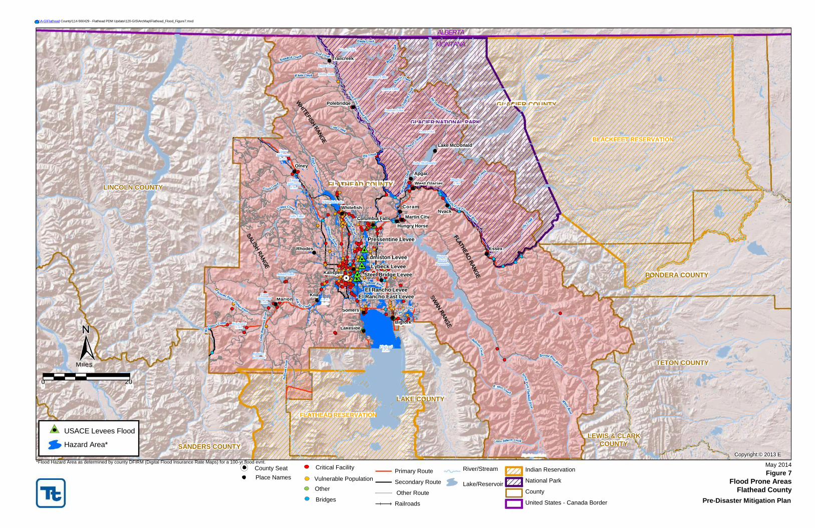
Development in floodplains results in a concurrent risk of property damage due to floods and impacts on
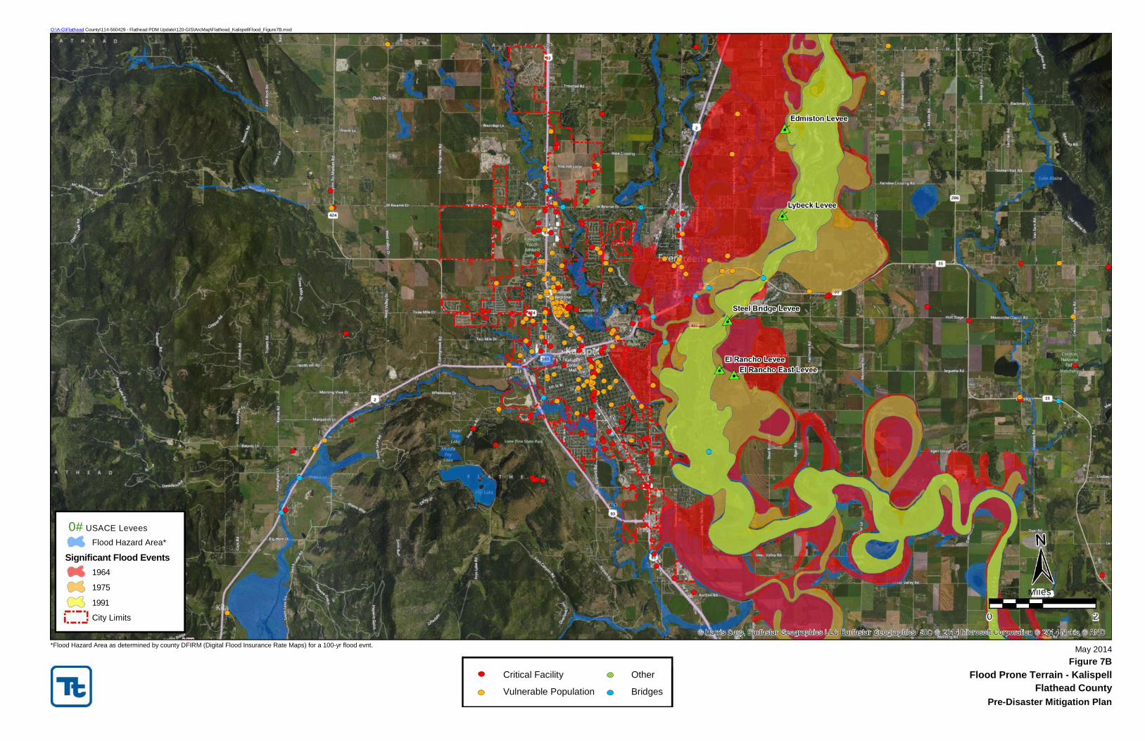
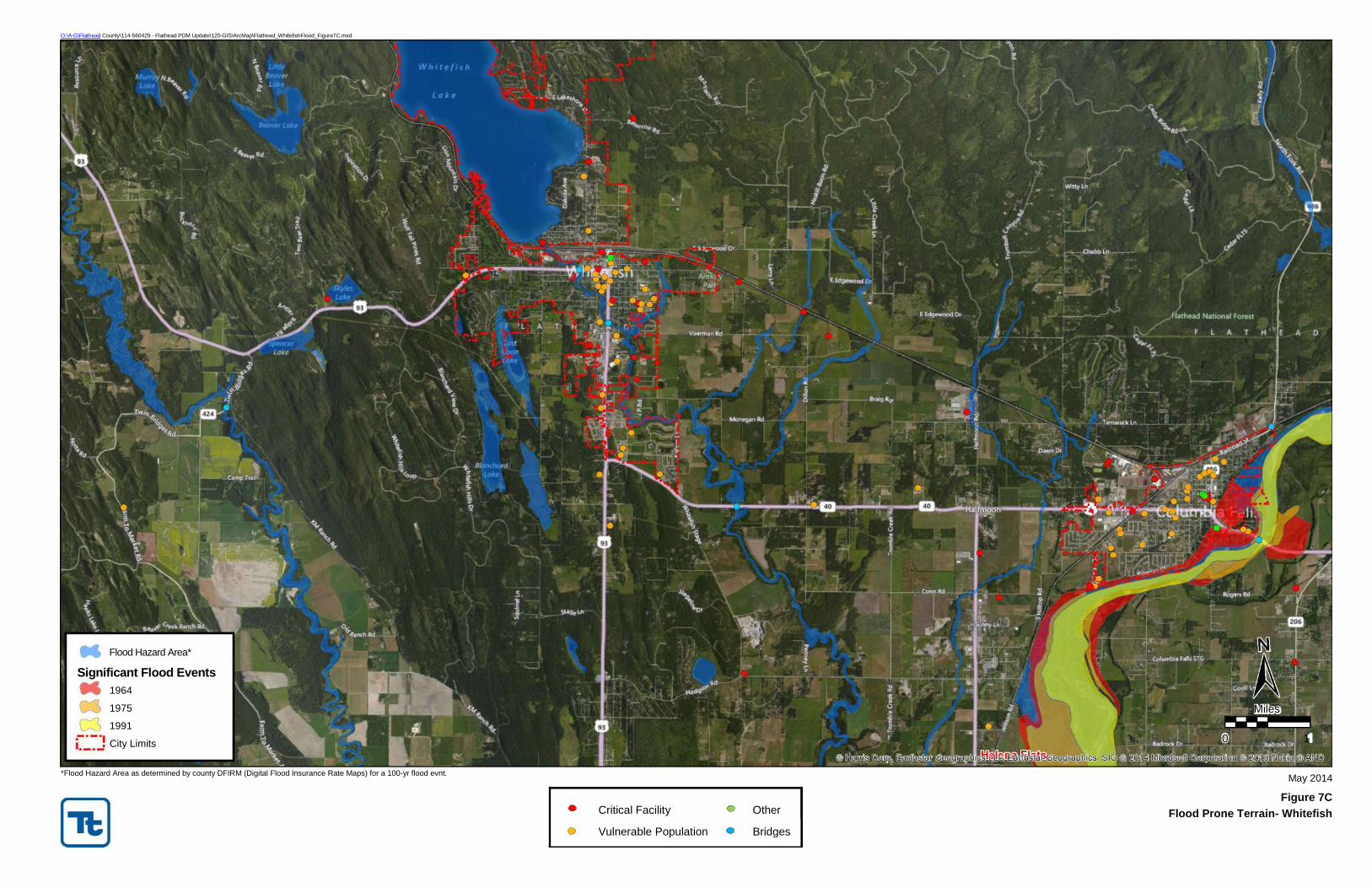
city services for risk protection during flood season. Figure 7 and 7A through 7C present the flood-prone
areas within Flathead County, Columbia Falls, Kalispell, and Whitefish, respectively. These maps were
developed from digital flood insurance rate maps (DFIRMs).
Tetra Tech Inc. 4-31 September 2014
Pre-Disaster Mitigation Plan Flathead County, Montana
Flood Protection Measures
As of the 2013 Continuing Eligibility Inspection, Flathead County has six levees on the Flathead River that
are included in the U.S. Army Corp of Engineers (USACE) PL84-99 Rehabilitation and Inspection Program
and considered active under the requirements of that program. The six levees are Edmiston, El Rancho, El
Rancho East, Lybeck, Pressentine and Steel Bridge. These levees are inspected every two years by the
USACE and Flathead County performs maintenance and repair work to keep these levees in the PL84-99
Program. In 2013 a seventh levee that had previously been active under the PL84-99 program (Pederson
Levee) was voluntarily withdrawn from the program by Flathead County because the work required by the
USACE to maintain the levee as active in the program after the 2011 inspection was cost prohibitive.
Other levees in Flathead County are not maintained by Flathead County at this time.
The Whitefish River has no manmade flood protection structure near Whitefish. However, the naturally
occurring high banks through the town provide adequate flood protection. Whitefish Lake provides flood
storage detention and some flow regulation along Whitefish River near Whitefish (FEMA, 2013).
Dams and reservoirs that affect the Flathead River Valley flooding are Hungry Horse Dam and Reservoir
on South Fork Flathead River and Kerr Dam on Flathead Lake on Flathead River.
Stillwater River has several small lakes which are capable of providing some flood detention in the upper
reaches of the watershed. Just north of Kalispell, there is a dike running along the left bank (looking
downstream) of Stillwater River in the area of the golf course. This dike has changed physical dimensions
several times due to recreational development in the area. This dike is not certified and is not reflected
on the FIRM. Along Stillwater River, there are other minor flood protection features, which are intended
to reduce overbank flooding and stabilize streambanks (FEMA, 2013).
Floodplain and Floodway Management
The National Flood Insurance Program (NFIP) encourages local governments to adopt “sound” floodplain
management programs to reduce private and public property losses due to floods. Flathead County and
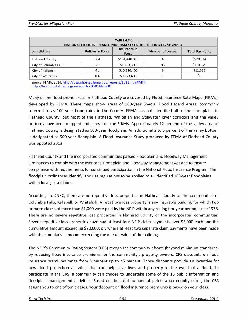
the incorporated communities participate in the NFIP. Table 4.3-1 presents statistics on flood insurance
policies and losses.
Tetra Tech Inc. 4-32 September 2014
Pre-Disaster Mitigation Plan Flathead County, Montana
TABLE 4.3-1
NATIONAL FLOOD INSURANCE PROGRAM STATISTICS (THROUGH 12/31/2013)
Jurisdictions Policies in Force Insurance in
Force Number of Losses Total Payments
Flathead County 584 $134,440,800 6 $528,914
City of Columbia Falls 8 $1,263,300 96 $110,829
City of Kalispell 41 $10,316,400 9 $11,085
City of Whitefish 106 $9,373,600 1 $0
Source: FEMA, 2014. http://bsa.nfipstat.fema.gov/reports/1011.htm#MTT; http://bsa.nfipstat.fema.gov/reports/1040.htm#30
Many of the flood prone areas in Flathead County are covered by Flood Insurance Rate Maps (FIRMs),
developed by FEMA. These maps show areas of 100-year Special Flood Hazard Areas, commonly
referred to as 100-year floodplains in the County. FEMA has not identified all of the floodplains in
Flathead County, but most of the Flathead, Whitefish and Stillwater River corridors and the valley
bottoms have been mapped and shown on the FIRMs. Approximately 12 percent of the valley area of
Flathead County is designated as 100-year floodplain. An additional 2 to 3 percent of the valley bottom
is designated as 500-year floodplain. A Flood Insurance Study produced by FEMA of Flathead County
was updated 2013.
Flathead County and the incorporated communities passed Floodplain and Floodway Management
Ordinances to comply with the Montana Floodplain and Floodway Management Act and to ensure
compliance with requirements for continued participation in the National Flood Insurance Program. The
floodplain ordinances identify land use regulations to be applied to all identified 100-year floodplains
within local jurisdictions.
According to DNRC, there are no repetitive loss properties in Flathead County or the communities of
Columbia Falls, Kalispell, or Whitefish. A repetitive loss property is any insurable building for which two
or more claims of more than $1,000 were paid by the NFIP within any rolling ten-year period, since 1978.
There are no severe repetitive loss properties in Flathead County or the incorporated communities.
Severe repetitive loss properties have had at least four NFIP claim payments over $5,000 each and the
cumulative amount exceeding $20,000; or, where at least two separate claim payments have been made
with the cumulative amount exceeding the market value of the building.
The NFIP’s Community Rating System (CRS) recognizes community efforts (beyond minimum standards)
by reducing flood insurance premiums for the community’s property owners. CRS discounts on flood
insurance premiums range from 5 percent up to 45 percent. Those discounts provide an incentive for
new flood protection activities that can help save lives and property in the event of a flood. To
participate in the CRS, a community can choose to undertake some of the 18 public information and
floodplain management activities. Based on the total number of points a community earns, the CRS
assigns you to one of ten classes. Your discount on flood insurance premiums is based on your class.
Tetra Tech Inc. 4-33 September 2014
Pre-Disaster Mitigation Plan Flathead County, Montana
Flathead County participates in the CRS and has a rating of “8” which provides a 10 percent discount on
flood insurance premiums.
Probability and Magnitude
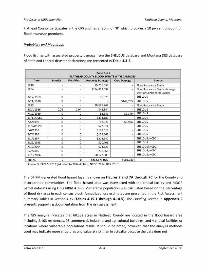
Flood listings with associated property damage from the SHELDUS database and Montana DES database
of State and Federal disaster declarations are presented in Table 4.3-2.
TABLE 4.3-2 FLATHEAD COUNTY FLOOD EVENTS WITH DAMAGES
Date Injuries Fatalities Property Damage Crop Damage Source
1948 - - $9,706,059 - Flood Insurance Study
1964 - - $184,869,097 - Flood Insurance Study (damage west of Continental Divide)
3/17/1969 0 0 $5,525 - SHELDUS
7/21/1970 0 0 - $148,765 SHELDUS
1975 - - $8,695,762 - Flood Insurance Study
2/24/1986 0.04 0.04 $42,844 - SHELDUS
7/12/1989 0 0 $2,349 $2,349 SHELDUS
11/11/1989 0 0 $313,189 - SHELDUS
7/5/1990 0 0 $8,926 $8,926 SHELDUS
11/24/1990 0 0 $22,314 - SHELDUS
6/6/1995 0 0 $178,518 - SHELDUS
2/7/1996 0 0 $155,863 - SHELDUS
5/1/1997 0 0 $302,647 - SHELDUS; NCDC
5/26/1998 0 0 $20,708 - SHELDUS
7/19/2004 0 0 $24,623 - SHELDUS; NCDC
6/2/2005 0 0 $208,568 - SHELDUS; NCDC
11/5/2006 0 0 $8,122,083 - SHELDUS; NCDC
TOTAL 0 0 $212,679,075 $160,040 Source: SHELDUS, 2013 (adjusted to 2014 dollars); NCDC, 2014; DES, 2013
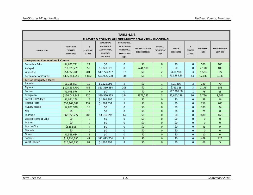
The DFIRM-generated flood hazard layer is shown on Figures 7 and 7A through 7C for the County and
incorporated communities. The flood hazard area was intersected with the critical facility and MDOR
parcel datasets using GIS (Table 4.3-3). Vulnerable population was calculated based on the percentage
of flood risk area in each census block. Annualized loss estimates are presented in the Risk Assessment
Summary Tables in Section 4.15 (Tables 4.15-1 through 4.14-5). The Flooding Section in Appendix C
presents supporting documentation from the risk assessment.
The GIS analysis indicates that 68,332 acres in Flathead County are located in the flood hazard area
including 2,103 residences, 95 commercial, industrial and agricultural buildings, and 4 critical facilities or
locations where vulnerable populations reside. It should be noted, however, that the analysis methods
used may indicate more structures and value at risk than in actuality because the data does not
Tetra Tech Inc. 4-34 September 2014
Pre-Disaster Mitigation Plan Flathead County, Montana
distinguish where on the parcel the structures are located and structures on any parcel “clipped” by the
hazard area are assumed to be at risk.
Based on the frequency of past events, the probability of flooding in Flathead County is rated as “likely”;
an event that may occur more than once per decade but not every year.
Future Development
Floodplain regulations exist in Flathead County and the cities of Columbia Falls, Kalispell, and Whitefish.
These regulations basically preclude new structural development within areas classified as designated
floodways under state law. Floodplain provisions in the Flathead County Subdivision Regulations, as well
as subdivision regulations for Columbia Falls, Kalispell and Whitefish, stipulate that land located in the
100-year floodplain or deemed subject to flooding shall not be subdivided for building or residential
purposes. Building in the 100-year floodplain requires state, federal, and local permits and buildings must
be elevated two feet above the base flood elevation with no basements. There are no restrictions for
building in the 500-year floodplain. The Subdivision Regulations also provide standards for flood hazard
evaluation in subdivision review.
Subdivision regulations for the City of Columbia Falls have provisions for high groundwater. Surface areas
where monitored groundwater elevations in four feet or less to the surface, generally from March 15
through June 30, cannot be subdivided for residential or development purposes unless public sewer
service is available or a property engineered private community waste water treatment system is
constructed.
The Flathead County Growth Policy (2012) includes two goals and several policies to address the flood
hazard:
Restrict development on lands that pose an unreasonable risk to the health, safety and general welfare
of all Flathead County residents.
Discourage high density development within the 500-year floodplain.
Discourage development within the 100-year floodplain that displaces floodwaters
to neighboring properties.
Encourage impact-mitigated development in areas of shallow groundwater. Use test holes
or bore holes and best available data to determine areas of shallow groundwater.
Preserve and protect floodplains to ensure the safety of residents from flood hazards and to prevent the
degradation of water quality and critical wildlife habitat.
Adopt FEMA maps and existing floodplain studies as they become available.
Review and revise floodplain regulations as necessary. Consider appropriate
setback requirements from floodplain.
Tetra Tech Inc. 4-35 September 2014
Pre-Disaster Mitigation Plan Flathead County, Montana
Discourage development in floodway or floodway fringe that may result in a net increase in
the floodplain area.
Consider density guidelines in the floodplain regulations.
Discourage development that displaces floodwaters within the 100-year floodplain.
The Flathead River to the east along with the Whitefish River and Stillwater River create a significant
amount of area that is restricted to development because it lies in the 100-year floodplain. Whenever
any type of fill is proposed in the 100-year floodplain, a floodplain development permit is required to be
obtained in accordance with the NFIP. The City of Kalispell’s Floodplain Development Permit
Implementation Strategy is:
Continue to participate in the NFIP to keep flood insurance rates low for all the residents of
the community.
Discourage fill in the 100-year floodplain when other viable options are available
for development.
Do not allow the creation of new subdivision lots in the 100-year floodplain when fill would
be required to establish a building site.
The City of Kalispell Growth Policy (2003) has one goal, and several policies and recommendations that
address the flood hazard:
Development near environmentally sensitive areas should be accomplished so that these features are left
in a relatively undisturbed state.
Development in environmentally sensitive areas including 100-year floodplain, wetlands,
riparian areas, shallow aquifers and on steep slopes may pose inherent development
limitations and design should be managed to avoid and mitigate environmental impacts and
natural hazards.
Filling of wetlands and the 100-year floodplain should be avoided.
Development should be designed to avoid the loss and minimize impacts to environmentally
sensitive areas including the 100-year floodplain, wetlands, riparian areas and shallow aquifers.
Recommendations:
The City should coordinate with the County in developing a community-wide drainage plan
encompassing the city and surrounding suburbs, to reduce water pollution and flooding.
Coordinate regulatory programs involving floodplain, habitat and water quality.
Maintain the integrity of environmentally sensitive areas in order prevent flooding, maintain
high water quality and prevent soil erosion.
Identify areas of the 100-year floodplain and other areas with limited development
potential that may be suitable for future park development.
Tetra Tech Inc. 4-36 September 2014
Pre-Disaster Mitigation Plan Flathead County, Montana
The City of Columbia Falls Growth Policy (2013) recognizes that floodplains present development
limitations in the eastern portion of their planning area where the Flathead River creates a large
floodplain area. Growth policies and recommendations include:
Development in 100-year floodplains should be managed to avoid and mitigate
environmental impacts and natural hazards.
Filling of the 100 year floodplain should be avoided.
Recommendations:
Protect the 100-year floodplain through implementation of the National Flood
Insurance Program for both the City and the County.
The City of Columbia Falls implemented a back flow prevention program which helps mitigate property
damage from flooding.
Flathead County Zoning Regulations (2012) and the Canyon Area Land Use Regulatory System (2004)
stipulate that structures shall not be located in a 100-year floodplain (floodway and flood fringe).
Neighborhood Plans for Ashley Lake, Bigfork, Helena Flats, Lakeside, North Fork, Riverdale and The
Canyon identify goals and policies associated with the flood hazard.
The Flathead City-County Health Department, which issues permits for all on-site sewage disposal
systems, does not allow a system in or within 100 feet of a designated 100-year floodplain because of
Department of Environmental Quality (DEQ) requirements that septic systems be 100 feet from surface
water.
Tetra Tech Inc. 4-37 September 2014
O:\A-G\Flathead County\114-560429 - Flathead PDM Update\120-GIS\ArcMap\Flathead_Flood_Figure7.mxd
0 20
USACE Levees Flood
Hazard Area*
Miles
LINCOLN COUNTY
SANDERS COUNTY
McGregor
Lake
£¤
2
Hubbart
Reservoir
Little
Bitterroot
Lake
Upper
Stillwater
Lake
Marion
Ashley Lake
Lower
Stillwater
Lake
Tally Lake
£¤28
Olney
Rhodes
FLATHEAD RESERVATION
£¤93
Kila!(
Miller Lake
Tepee Lake
S m i t h L a k e
Whitefish Lake
Kalispell
Polebridge
FLATHEAD COUNTY !(
Trailcreek
£¤ 9 3 ! ( ! (
Kintla Lake
Whitefish
Lakeside
Somers
£¤2 !( !( !( !(
!(")40
!(!(
Columbia Falls
El Rancho East Levee
Pressentine Levee
!(")206
Edmiston Levee
Lybeck Levee !(Steel Bridge Levee
! ( ! ( ! ( ! ( ! (
El Rancho Levee
Bowman Lake
")82 ")35 !( !(
!( ")83
!(
")486
F l a t h e a
d L a k e
Quartz Lake
Logging Lake
Bigfork
Hungry Horse
LAKE COUNTY
Coram
Martin City
GLACIER NATIONAL PARK
Lake McDonald
Apgar
West Glacier
Trout Lake
MONTANA
ALBERTA
Hungry
Horse
Reservoir
Nyack
Lake McDonald
Harrison
Lake
£¤2
Essex
u
GLACIER COUNTY
Big Salmon Lake
LEWIS & CLARK
COUNTY
BLACKFEET RESERVATION
PONDERA COUNTY
TETON COUNTY
Copyright:© 2013 E
*Flood Hazard Area as determined by county DFIRM (Digital Flood Insurance Rate Maps) for a 100-yr flood evnt.
Vulnerable Population
Critical Facility
River/Stream
Lake/Reservoir
County Seat Place Names
Bridges
May 2014
Figure 7
Flood Prone Areas
Flathead County
Pre-Disaster Mitigation Plan
Primary Route
Secondary Route
Other Route
Railroads
Indian Reservation
National Park
County
United States - Canada Border
Other
*Flood Hazard Area as determined by county DFIRM (Digital Flood Insurance Rate Maps) for a 100-yr flood evnt.
May 2014
Figure 7A
Critical Facility Other Flood Prone Terrain - Columbia Falls
Vulnerable Population Bridges Flathead County
Pre-Disaster Mitigation Plan
O:\A-G\Flathead County\ 11 4-5 6 04 29 - Flathead PDM Update\120-GIS\ArcMap\Flathead_ColumbiaFallsFlood_Figure7A.mxd
Flood Hazard Area*
Significant Flood Events
1964
1975
1991
City Limits 0 0.5
Miles
*Flood Hazard Area as determined by county DFIRM (Digital Flood Insurance Rate Maps) for a 100-yr flood evnt.
May 2014
Figure 7B
Critical Facility Other Flood Prone Terrain - Kalispell
Vulnerable Population Bridges Flathead County
Pre-Disaster Mitigation Plan
O:\A-G\Flathead County\114-560429 - Flathead PDM Update\120-GIS\ArcMap\Flathead_KalispellFlood_Figure7B.mxd
0# USACE Levees Flood Hazard Area*
Significant Flood Events
1964
1975
1991
City Limits 0 2
Miles
*Flood Hazard Area as determined by county DFIRM (Digital Flood Insurance Rate Maps) for a 100-yr flood evnt.
May 2014
Figure 7C
Flood Prone Terrain- Whitefish Critical Facility Other
Vulnerable Population Bridges
Flathead County
O:\A-G\Flathead County\114-560429 - Flathead PDM Update\120-GIS\ArcMap\Flathead_WhitefishFlood_Figure7C.mxd
Flood Hazard Area*
Significant Flood Events
1964
1975
1991
City Limits 0 1
Miles
Pre-Disaster Mitigation Plan Flathead County, Montana
TABLE 4.3-3
FLATHEAD COUNTY VULNERABILITY ANALYSIS – FLOODING
JURISDICTION
RESIDENTIAL
PROPERTY
EXPOSURE$
#
RESIDENCES
AT RISK
COMMERCIAL,
INDUSTRIAL &
AGRICULTURAL
PROPERTY
EXPOSURE$
# COMMERCIAL,
INDUSTRIAL &
AGRICULTUAL
PROPERTIES AT
RISK
CRITICAL FACILITIES
EXPOSURE RISK$
# CRITICAL
FACILITIES AT
RISK
BRIDGE
EXPOSURE$
#
BRIDGES
AT RISK
PERSONS AT
RISK
PERSONS UNDER
18 AT RISK
Incorporated Communities & County
Columbia Falls $4,627,771 24 $0 0 $0 0 $0 0 500 100
Kalispell $12,025,723 56 $1,220,620 8 $241,180 1 $0 0 2,120 486
Whitefish $54,556,085 201 $17,773,297 37 $0 2 $616,908 3 1,533 327
Remainder of County $495,843,950 1,822 $24,995,530 50 $0 1 $12,388,28 43 17,030 3,930
Census Designated Places Batavia $3,155,807 19 $1,525,996 5 $0 1 $91,436 2 239 70 Bigfork $105,534,700 485 $53,310,884 208 $0 2 $769,328 3 2,175 353 Coram $1,095,576 7 $0 0 $0 0 $12,360,00 1 76 13 Evergreen $150,043,842 720 $89,550,375 194 $971,782 3 $2,660,278 10 5,796 1,503
Forest Hill Village $1,051,268 5 $1,462,396 1 $0 0 $0 0 59 16 Helena Flats $33,169,687 137 $1,808,852 5 $0 0 $0 0 758 203 Hungry Horse $4,877,920 19 $0 0 $0 0 $0 0 180 34 Kila $0 0 $0 0 $0 0 $0 0 21 0
Lakeside $68,358,777 283 $3,636,592 14 $0 0 $0 0 880 166
Little Bitterroot Lake $0 0 $0 0 $0 0 $0 0 0 0 Marion $0 0 $0 0 $0 0 $0 0 0 0
Martin City $625,895 4 $0 0 $0 0 $0 0 43 9 Niarada $0 0 $0 0 $0 0 $0 0 0 0
Olney $1,563,684 5 $0 0 $0 0 $0 0 10 0 Somers $13,834,395 47 $12,093,704 11 $0 0 $0 0 469 125
West Glacier $16,848,930 87 $1,892,499 8 $0 0 $0 0 68 5
Tetra Tech Inc. 4-42 September 2014