Embed Size (px)
Citation preview
4.4 – Geology and Soils
City of Huntington Beach Draft Program Environmental Impact Report Downtown Specific Plan Update page 4-67
4.4 Geology and Soils
The information and analysis presented in this section of the EIR are based on the City’s General Plan, Environmental Hazards Element.
4.4.1 86BEnvironmental Setting
1. Physical Setting
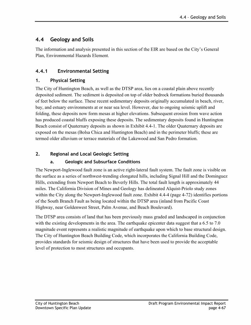
The City of Huntington Beach, as well as the DTSP area, lies on a coastal plain above recently deposited sediment. The sediment is deposited on top of older bedrock formations buried thousands of feet below the surface. These recent sedimentary deposits originally accumulated in beach, river, bay, and estuary environments at or near sea level. However, due to ongoing seismic uplift and folding, these deposits now form mesas at higher elevations. Subsequent erosion from wave action has produced coastal bluffs exposing these deposits. The sedimentary deposits found in Huntington Beach consist of Quaternary deposits as shown in Exhibit 4.4-1. The older Quaternary deposits are exposed on the mesas (Bolsa Chica and Huntington Beach) and in the perimeter bluffs; these are termed older alluvium or terrace materials of the Lakewood and San Pedro formation.
2. Regional and Local Geologic Setting
a. Geologic and Subsurface Conditions
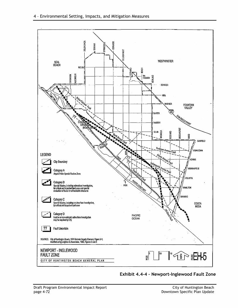
The Newport-Inglewood fault zone is an active right-lateral fault system. The fault zone is visible on the surface as a series of northwest-trending elongated hills, including Signal Hill and the Dominguez Hills, extending from Newport Beach to Beverly Hills. The total fault length is approximately 44 miles. The California Division of Mines and Geology has delineated Alquist-Priolo study zones within the City along the Newport-Inglewood fault zone. Exhibit 4.4-4 (page 4-72) identifies portions of the South Branch Fault as being located within the DTSP area (inland from Pacific Coast Highway, near Goldenwest Street, Palm Avenue, and Beach Boulevard).
The DTSP area consists of land that has been previously mass graded and landscaped in conjunction with the existing developments in the area. The earthquake epicenter data suggest that a 6.5 to 7.0 magnitude event represents a realistic magnitude of earthquake upon which to base structural design. The City of Huntington Beach Building Code, which incorporates the California Building Code, provides standards for seismic design of structures that have been used to provide the acceptable level of protection to most structures and occupants.
4 – Environmental Setting, Impacts, and Mitigation Measures
Draft Program Environmental Impact Report City of Huntington Beach page 4-68 Downtown Specific Plan Update
Exhibit 4.4-1 – Surface Geology
4.4 – Geology and Soils
City of Huntington Beach Draft Program Environmental Impact Report Downtown Specific Plan Update page 4-69
b. Subsurface Materials
The mesas are surrounded and separated by younger alluvium deposits which fill the gaps in low lying areas of the City. Younger alluvium is divided into river floodplain deposits (washed in from the northeast as sand, gravel and silt), and tidal flat/lagoonal type deposits that lie in the gaps (finer grained silts and clays). Peat and organic soils are found within the younger alluvium up to about 25 feet (average 5 to 10 feet thick). These fine-grained deposits are expansive, compressible, and generally have fair to poor geotechnical engineering properties. Flood plain sands and silts are largely unconsolidated and contain peat layers. On the whole, these deposits are subject to liquefaction (fine sand and peat), settlement, expansion, and have good to fair engineering properties, except for peat which has poor to very poor engineering properties.
c. Groundwater Condition
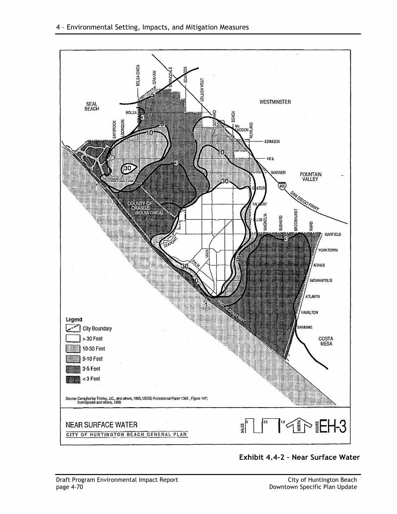
Huntington Beach is underlain by shallow near surface water, which is of interest with regard to liquefaction potential (within depths of 0 to 50 feet) and as a hazard for construction (within depths of 0 to 30 feet). Exhibit 4.4-2 shows the near surface water contours of the City. This water is found in the alluvial valley and mesa areas as perched water and in shallow aquifers. In the gap areas between the mesas, the City appears to be entirely underlain by water at less than 50 feet deep. These alluvial floodplain (gap) areas have the greatest concentration of shallow water with depths less than 30 feet and most often less than 5 feet deep. Narrow strips along the immediate coastline have water depths of less than 10 feet. Recent projects (The Strand and Pacific City) within the DTSP have encountered groundwater. However, it is likely that areas of near surface groundwater are localized and the presence of groundwater would vary as a result of climatic effects and that the occurrence of shallow groundwater may not be present throughout the DTSP area. Therefore, proposed future development projects will need to be assessed on a site-specific basis to determine the presence of shallow groundwater.
3. Seismic and Geologic Hazards
a. Faults and Seismicity
The entire DTSP area is located within an Alquist-Priolo Earthquake Fault Zone for the Newport-Inglewood fault. The DTSP area is susceptible to levels of seismic ground shaking typical for much of Southern California. All structural features constructed pursuant to the DTSP would be designed and constructed to withstand the type and intensity of ground shaking associated with faults.
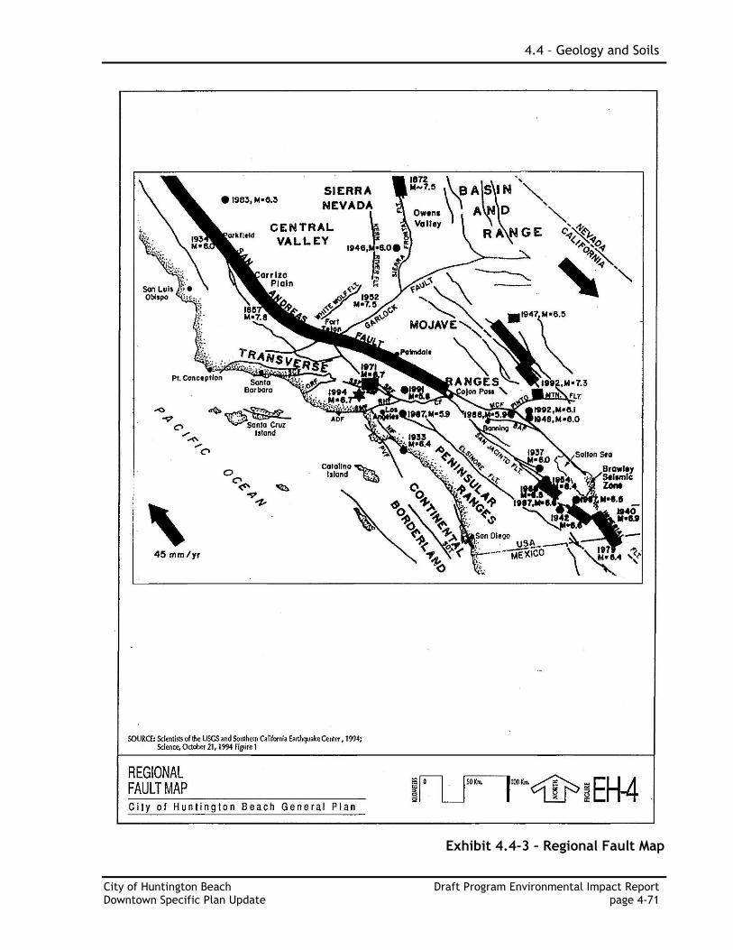
Other nearby faults in the region are shown on Exhibit 4.4-3 – Regional Fault Map. The Newport-Inglewood Fault Zone is displayed on Exhibit 4.4-4.
All of Southern California, including the project site, is considered to be a seismically active region. Seismic hazards that may affect the site include ground shaking, liquefaction, and dynamic settlement.
4 – Environmental Setting, Impacts, and Mitigation Measures
Draft Program Environmental Impact Report City of Huntington Beach page 4-70 Downtown Specific Plan Update
Exhibit 4.4-2 – Near Surface Water
4.4 – Geology and Soils
City of Huntington Beach Draft Program Environmental Impact Report Downtown Specific Plan Update page 4-71
Exhibit 4.4-3 – Regional Fault Map
4 – Environmental Setting, Impacts, and Mitigation Measures
Draft Program Environmental Impact Report City of Huntington Beach page 4-72 Downtown Specific Plan Update
Exhibit 4.4-4 – Newport-Inglewood Fault Zone
4.4 – Geology and Soils
City of Huntington Beach Draft Program Environmental Impact Report Downtown Specific Plan Update page 4-73
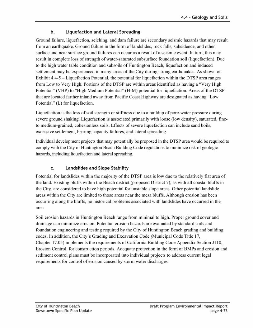
b. Liquefaction and Lateral Spreading
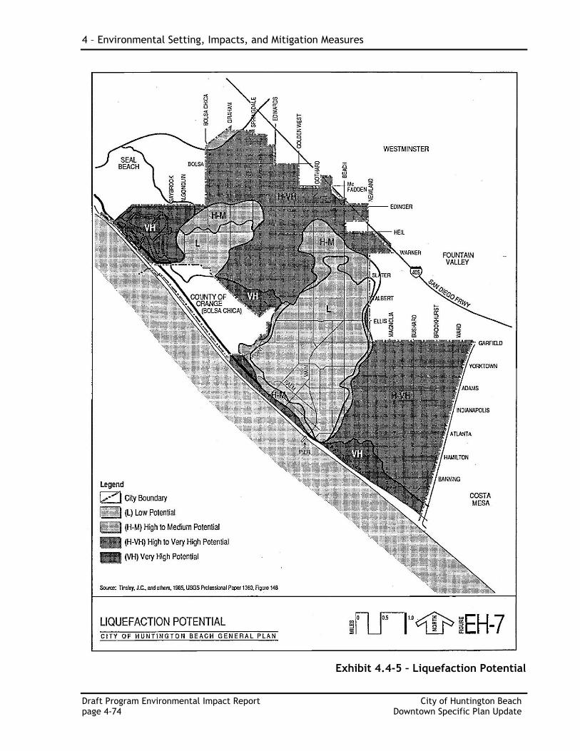
Ground failure, liquefaction, seiching, and dam failure are secondary seismic hazards that may result from an earthquake. Ground failure in the form of landslides, rock falls, subsidence, and other surface and near surface ground failures can occur as a result of a seismic event. In turn, this may result in complete loss of strength of water-saturated subsurface foundation soil (liquefaction). Due to the high water table condition and subsoils of Huntington Beach, liquefaction and induced settlement may be experienced in many areas of the City during strong earthquakes. As shown on Exhibit 4.4-5 – Liquefaction Potential, the potential for liquefaction within the DTSP area ranges from Low to Very High. Portions of the DTSP are within areas identified as having a “Very High Potential” (VHP) to “High Medium Potential” (H-M) potential for liquefaction. Areas of the DTSP that are located farther inland away from Pacific Coast Highway are designated as having “Low Potential” (L) for liquefaction.
Liquefaction is the loss of soil strength or stiffness due to a buildup of pore-water pressure during severe ground shaking. Liquefaction is associated primarily with loose (low density), saturated, fine- to medium-grained, cohesionless soils. Effects of severe liquefaction can include sand boils, excessive settlement, bearing capacity failures, and lateral spreading.
Individual development projects that may potentially be proposed in the DTSP area would be required to comply with the City of Huntington Beach Building Code regulations to minimize risk of geologic hazards, including liquefaction and lateral spreading.
c. Landslides and Slope Stability
Potential for landslides within the majority of the DTSP area is low due to the relatively flat area of the land. Existing bluffs within the Beach district (proposed District 7), as with all coastal bluffs in the City, are considered to have high potential for unstable slope areas. Other potential landslide areas within the City are limited to those areas near the mesa bluffs. Although erosion has been occurring along the bluffs, no historical problems associated with landslides have occurred in the area.
Soil erosion hazards in Huntington Beach range from minimal to high. Proper ground cover and drainage can minimize erosion. Potential erosion hazards are evaluated by standard soils and foundation engineering and testing required by the City of Huntington Beach grading and building codes. In addition, the City’s Grading and Excavation Code (Municipal Code Title 17, Chapter 17.05) implements the requirements of California Building Code Appendix Section J110, Erosion Control, for construction periods. Adequate protection in the form of BMPs and erosion and sediment control plans must be incorporated into individual projects to address current legal requirements for control of erosion caused by storm water discharges.
4 – Environmental Setting, Impacts, and Mitigation Measures
Draft Program Environmental Impact Report City of Huntington Beach page 4-74 Downtown Specific Plan Update
Exhibit 4.4-5 – Liquefaction Potential
4.4 – Geology and Soils
City of Huntington Beach Draft Program Environmental Impact Report Downtown Specific Plan Update page 4-75
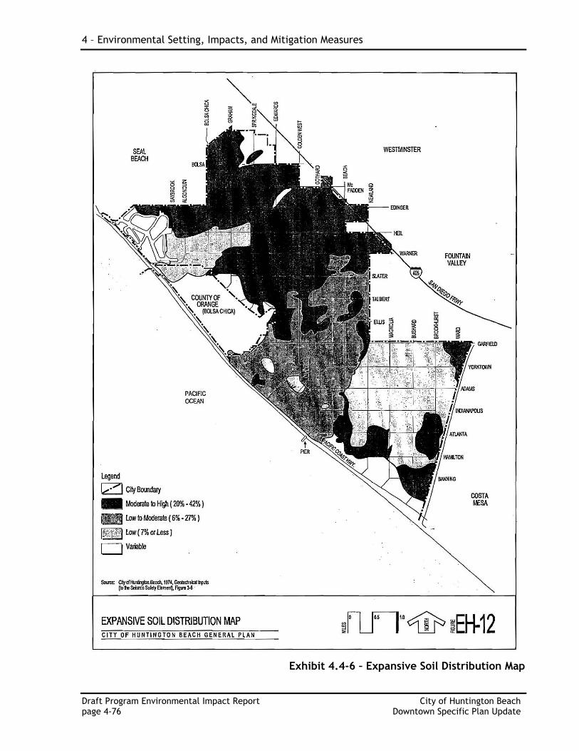
d. Expansive Soils
Expansive soils are generally defined as those soils that exhibit a change in volume when moisture content of the soil is varied. Expansive and collapsible soils can affect building foundations, resulting in damage to the structure. Movements may vary under different parts of a building with the result that the foundations crack, with vertical displacement causing various structural portions of the building to be damaged and/or destroyed. Exhibit 4.4-6 – Expansive Soil Distribution Map identifies areas within the DTSP as having a low to moderate potential for expansive soils. Risks associated with expansive soil are addressed through compliance with the City of Huntington Beach Building Code and the Grading and Excavation Code, as well as engineering and construction practices to reduce potential impacts to less than significant.
e. Flooding, Seiches and Tsunamis
As of March 30, 2009, the DTSP area (except for areas seaward of Pacific Coast Highway) is in Zone X, an area determined to be outside the 2% annual chance floodplain as defined by the Federal Emergency Management Agency.
Seiches are large waves generated in enclosed bodies of water in response to ground shaking. The site is not located downslope of any large bodies of water that could adversely impact the site in the event of earthquake-induced failures or seiches. Therefore, the potential of seiches at the site is considered negligible.
Tsunamis are sea waves generated by a large-scale disturbance of the ocean floor that induces a rapid displacement of the water column above. The area of the DTSP that is potentially vulnerable to tsunami is the area located immediately adjacent to Pacific Coast Highway on both the ocean and inland side. Most of the DTSP area is not susceptible to impacts from tsunamis; however, a small area that encompasses development sites in the Beach district (District 7), Pacific City (Districts 2 and 5), and the Waterfront (District 3 and 5) is within a moderate tsunami run-up area. The NOP/Initial Study (Appendix A) identified potential impacts and provided a mitigation measure for projects proposed on sites within the moderate tsunami run-up area. The analysis and mitigation measure can be found in Section 4.6, Hydrology and Water Quality (beginning on page 4-89).
f. Methane
The entire DTSP area is located within a Methane Overlay District identified in the City’s General Plan. As such, the Huntington Beach Fire Department requires a developer to implement a site soils testing plan at a project site in accordance with City Specification 429 to determine the presence of methane gas. If methane gas is detected, a Remediation Plan would be required, subject to review and approval by the Fire Department.
4 – Environmental Setting, Impacts, and Mitigation Measures
Draft Program Environmental Impact Report City of Huntington Beach page 4-76 Downtown Specific Plan Update
Exhibit 4.4-6 – Expansive Soil Distribution Map
4.4 – Geology and Soils
City of Huntington Beach Draft Program Environmental Impact Report Downtown Specific Plan Update page 4-77
4. Regulatory Setting
The City adopted the 2007 California Building Code (CBC) as the basis for its own Building Code (Municipal Code Title 17, Chapter 17.04). The Building Code, as adopted, includes acceptable variations to the CBC related to minimum slab thickness, fire-extinguishing systems, building security, and methane district regulations. The Grading and Excavation Code (adopted by the City on November 3, 2003 through Ordinance No. 3621 as Municipal Code Title 17) sets forth rules and regulations to control excavation, grading, earthwork, and site improvement construction, and establishes administrative requirements for issuance of permits and approvals of plans and inspection of grading construction. Specifically, the Grading and Excavation Code identifies, defines, and regulates hazardous conditions, plans and specifications, soils and geology reports, fills, setbacks, drainage and terracing, asphalt concrete pavement, and erosion control systems. These two code chapters stipulate the requirements for proposed new development in the City to address geotechnical issues, including all aspects of geologic and engineering site investigation, seismic-resistance foundation and building design, and slope and soil stability including erosion and sediment control. Development is required to comply with the Huntington Beach Building Code, the Grading and Excavation Code, and all state requirements pertaining to geologic, soil, and seismic hazards. With this regulatory framework in place, the City has the authority to enforce the General Plan policies protecting the public from geotechnical hazards associated with proposed development.
4.4.2 87BSignificance Criteria
This analysis addresses the potential for the project to result in impacts related to geology and soils. Factors considered in determining impact significance include whether the proposed project would:
Expose people or structures to potential substantial adverse effects, including the risk of loss, injury, or death involving:
i) Rupture of a known earthquake fault, as delineated on the most recent Alquist-Priolo Earthquake Fault Zoning Map issued by the State Geologist for the area or based on other substantial evidence of a known fault. Refer to Division of Mines and Geology Special Publication 42.
ii) Strong seismic ground shaking. iii) Seismic-related ground failure, including liquefaction. iv) Landslides
Result in substantial soil erosion or the loss of topsoil.
Be located on a geologic unit or soil that is unstable, or that would become unstable as a result of the project and potentially result in on- or off-site landslide, lateral spreading, subsidence, liquefaction or collapse.
Be located on expansive soil, as defined in Table 18-1-B of the Uniform Building Code (1994), creating substantial risks to life or property.
4 – Environmental Setting, Impacts, and Mitigation Measures
Draft Program Environmental Impact Report City of Huntington Beach page 4-78 Downtown Specific Plan Update
Have soils incapable of adequately supporting the use septic tanks or alternative waste water disposal systems where sewers are not available for the disposal of waste water. (This criterion is not applicable to the proposed project because public sewer service is proposed and available to serve the project.)
4.4.3 88BImpacts
The proposed project consists of an Update to the Downtown Specific Plan (DTSP). The DTSP is a planning document that sets forth the regulatory framework for future development within the DTSP area. The project does not propose construction of buildings or structures. In order to assess impacts, criteria of significance include whether the proposed project would:
Expose people or structures to potential substantial adverse effects, including the risk of loss, injury, or death involving:
(i) Rupture of a known earthquake fault, as delineated on the most recent Alquist-Priolo Earthquake Fault Zoning Map issued by the State Geologist for the area or based on other substantial evidence of a known fault. Refer to Division of Mines and Geology Special Publication 42.
Regional faults create the potential for ground shaking impacts within the DTSP area. The entire area is at risk for damage caused by ground shaking and seismic activity. With the increase in development and population allowed under the proposed DTSP Update, the number of people and buildings exposed to seismic ground shaking would increase. This is considered a potentially significant impact. However, construction of new buildings or structures in the DTSP area would require specific engineering and design measures to be implemented in order to anticipate and avoid potential impacts from seismic events and activity. Additionally, all future development would be required to perform a site-specific Geotechnical Report that includes design and foundation recommendations and adheres to the City’s Municipal Code. Adherence to the seismic design and construction parameters of the CBC, the City’s Municipal Code, and recommendations outlined in a site specific Geotechnical Report would ensure protection of residents, tenants, and visitors within the DTSP area. As such, compliance with Mitigation Measure MM 4.4-1 is proposed for future development within the DTSP to reduce impacts to a less than significant level.
Result in substantial soil erosion or the loss of topsoil.
The DTSP area, in general, represents a developed area that has been disturbed in the past. There is limited vacant land available; however, the proposed project consists of an update to the existing DTSP that would accommodate future development and redevelopment through revised development standards, regulations, and guidelines. Future development under the proposed Specific Plan would result in ground-disrupting activities such as excavation and trenching for foundations and utilities, soil compaction and site grading, and the erection of new structures, all of which would temporarily disturb soils. The exposure of previously
4.4 – Geology and Soils
City of Huntington Beach Draft Program Environmental Impact Report Downtown Specific Plan Update page 4-79
covered soils during these activities could lead to increased on-site erosion and off-site sediment transport because disturbed soils are susceptible to higher rates of erosion from wind, rain, and runoff of dewatering discharge or dust control water than undisturbed soils. The State Water Resources Control Board and the City’s Municipal Code require erosion and sediment controls for construction projects with land disturbance. The City’s Grading and Excavation Code (Municipal Code Title 17, Chapter 17.05), which implements the requirements of CBC Appendix Section J110, Erosion Control, for construction periods, addresses the issue of soil loss. The requirements include preparation and implementation of a Storm Water Pollution Prevention Plan (SWPPP), with both construction-period and permanent erosion and sediment controls, preparation and implementation of an erosion and sediment control plan that describes construction-period and permanent erosion and sediment controls, and construction site inspection by the City. Future development under the Specific Plan would be required to comply with these existing regulations. Adherence to these requirements would prevent substantial on-site erosion and would reduce impacts to a less-than-significant level from the perspective of soil loss at a construction site.
Off-site erosion and sedimentation could occur if increased storm water runoff were conveyed over unstable off-site soil surfaces or to a susceptible creek or channel where the higher erosive forces associated with increased flow rates could contribute to off-site erosion, including stream bed and bank erosion. Because all storm water from the Specific Plan area would continue to be conveyed through the City’s storm drainage system, storm water runoff would not flow over unstable off-site soil surfaces, and there would be a low probability of erosion or sedimentation involving them.
Earth-disturbing activities associated with construction would be temporary. Specific erosion impacts would depend largely on the areas affected and the length of time soils are subject to conditions that would be affected by erosion processes. Any project sites one acre in size or larger are subject to the provisions of the Construction Activity Storm Water General Permit adopted by the State Water Resources Control Board (SWRCB). Applicants for specific development projects must submit a Notice of Intent (NOI) to the SWRCB for coverage under the Statewide General Construction Activity Storm Water Permit and must comply with all applicable requirements, including the preparation of a SWPPP, applicable NPDES regulations, and best management practices (BMP). The SWPPP must describe the site, the facility, erosion and sediment controls, runoff water quality monitoring, means of waste disposal, implementation of approved local plans, control of sediment and erosion control measures, maintenance responsibilities, and non-storm water management controls. Inspection of construction sites before and after storms is required to identify storm water discharge from the construction activity and to identify and implement controls where necessary. Such compliance, in addition to implementation of Mitigation Measure MM 4.4-1 and Code Requirement 4.4-1, would ensure that erosion and other soil instability impacts resulting from future construction within the project site would be less than significant.
4 – Environmental Setting, Impacts, and Mitigation Measures
Draft Program Environmental Impact Report City of Huntington Beach page 4-80 Downtown Specific Plan Update
Be located on a geologic unit or soil that is unstable, or that would become unstable as a result of the project and potentially result in on- or off-site landslide, lateral spreading, subsidence, liquefaction or collapse.
The DTSP area is a relatively flat area, although there are coastal bluffs within the Beach district (District 7). However, none of the net new development potential identified is anticipated to occur within this district. The project does identify an area within the Beach district for a potential tiered-parking structure, but would limit the area to the existing developed parking lot footprint. The remainder of the DTSP area is identified as having no potential for slope instability. Slope stability issues related to the sides of excavation during construction of projects within the DTSP area are regulated by the City’s Municipal Code. Adherence to the City’s Municipal Code, Mitigation Measure MM 4.4-1 and Code Requirement CR 4.4-1 and the design recommendations of the Geotechnical Investigation to be prepared for all future development would ensure that less than significant impacts from unstable slopes and landslides would occur with implementation of the DTSP Update.
It is likely that some of the projects that will be proposed in the DTSP Update will include subterranean parking, like several of the projects that have been constructed (or are under construction) in the area. Because of the shallow depth of groundwater, dewatering activities in the DTSP area could be needed during construction of any subterranean levels, such as for parking. The removal of groundwater to create a dry construction pit could cause porous soils to collapse when the support provided by the water was withdrawn. Temporary shoring, dewatering wells, storage tanks, filters, and erosion control measures would be required to comply with the City’s Grading Manual (Chapter 17.05.030 of the Huntington Beach Municipal Code). In addition, dewatering activities would be required to comply with the NPDES Permit for Groundwater Discharge from the Santa Ana Regional Water Quality Control Board.
Because future structures would be designed, constructed, and operated in conformance with Section 1802.2.1 Questionable Soils, of the City’s Municipal Code and Title 17 Excavation and Grading Code, and because the project would be required to comply with Mitigation Measure MM 4.4-1 and Code Requirement CR 4.4-1, potential risks to life and property from unstable soils caused by groundwater saturation or withdrawal would be less than significant.
Be located on expansive soil, as defined in Table 18-1-B of the Uniform Building Code (1994), creating substantial risks to life or property.
The DTSP area has low to moderate potential for expansive soils. If future development occurs on sites with underlying expansive soils, treatment programs to eliminate expansion of soils that could include, but are not limited to, grouting (cementing the soil particles together), recompaction (watering and compressing the soils), and replacement with a non-expansive material (excavation of unsuitable soil followed by filling with suitable material) could be utilized to achieve soil stability. Because future structures would be designed, constructed, and operated in conformance with Section 1802.2.2 Expansive Soils, of the
4.4 – Geology and Soils
City of Huntington Beach Draft Program Environmental Impact Report Downtown Specific Plan Update page 4-81
City’s Municipal Code and Title 17 Excavation and Grading Code, and because the project would be required to comply with Mitigation Measure MM 4.4-1 and Code Requirement CR 4.4-1, potential risks to life and property associated with expansive soil would be reduced to a less than significant level.
Have soils incapable of adequately supporting the use septic tanks or alternative waste water disposal systems where sewers are not available for the disposal of waste water.
The DTSP area is required to be served by a sewer system that is designed and planned for Huntington Beach. It is not anticipated that the DTSP Update will result in any significant impacts associated with septic tanks or alternative waste water disposal systems.
4.4.4 89BMitigation Measures
MM 4.4-1 Future development in the DTSP area shall prepare a grading plan, subject to review and approval by the City’s development services departments, to contain the recommendations of the required final soils and geotechnical report. These recommendations shall be implemented in the design of the project, including but not limited to measures associated with site preparation, fill placement, temporary shoring and permanent dewatering, groundwater seismic design features, excavation stability, foundations, soils stabilization, establishment of deep foundations, concrete slabs and pavements, surface drainage, cement type and corrosion measures, erosion control, shoring and internal bracing, and plan review.
CR 4.4-1 A California-licensed Civil Engineer (Geotechnical) shall prepare and submit to the City a detailed soils and geotechnical analysis with the first submittal of a grading plan. This analysis shall include Phase II Environmental soils sampling and laboratory testing of materials to provide detailed recommendations for grading, chemical and fill properties, liquefaction, and landscaping.
4.4.5 90BLevel of Significance after Mitigation
With implementation of the recommended mitigation measures and code requirements, the project’s adverse significant geology and soils impacts will be reduced to a level of insignificance.
4.4.6 91BSignificant and Unavoidable Impacts
The DTSP Update carries no significant and unavoidable impacts from geological and soils that cannot be reduced to a level of insignificance through mitigation measures.
4 – Environmental Setting, Impacts, and Mitigation Measures
Draft Program Environmental Impact Report City of Huntington Beach page 4-82 Downtown Specific Plan Update
4.4.7 92BCumulative Impacts
Impacts from geologic hazards are generally site and project specific. As such, potential for cumulative impacts to occur is limited. Each project site has unique geologic considerations that would be subject to uniform site development policies and construction standards imposed by the City of Huntington Beach. Restrictions on development would be applied in the event that geologic or soil conditions posed a risk to public safety. Impacts associated with potential geologic hazards related to soil or other conditions could occur at individual project sites. These effects would be site-specific, and impacts would not be compounded by additional development. During construction, areas of soil could be exposed to erosion by wind or water. Development of other cumulative projects in the vicinity of the proposed project could expose soil surfaces and further alter soil conditions, subjecting soils to erosional processes during construction. To minimize the potential for cumulative impacts that could cause erosion, the proposed project and cumulative projects in the adjacent area are required to be developed in conformance with the provisions of applicable federal, state, county, and city laws and ordinances. Adherence to all relevant plans, codes, and regulations with respect to project design and construction would provide adequate levels of safety, and the cumulative impact would be less than significant.