Embed Size (px)
Citation preview

Chapter 4: North Study Area Analysis | 4.6 Geology and Soils | 105
34
5Description ofAlternatives
North Study Area Analysis
2Setting, Planning and Outreach
1Introduction /Need and Purpose
South Study AreaAnalysis
4.6 GEOLOGY AND SOILSGeologic and soil conditions are important factors for a project as they can greatly affect the design and construction of any planned road improvements. Soil conditions can also influence the impact of project construction on the surrounding environment. A Geology and Soils Technical Memorandum was prepared for the Build Alternative (See Appendix B for access information). The memorandum describes the existing soil and geologic conditions, methodology and information sources used to evaluate existing conditions, and includes a detailed discussion of potential impacts with and without the Build Alternative.
4.6.1 What Methods, Assumptions and Resources Were Considered in the Evaluation of Geology and Soils?
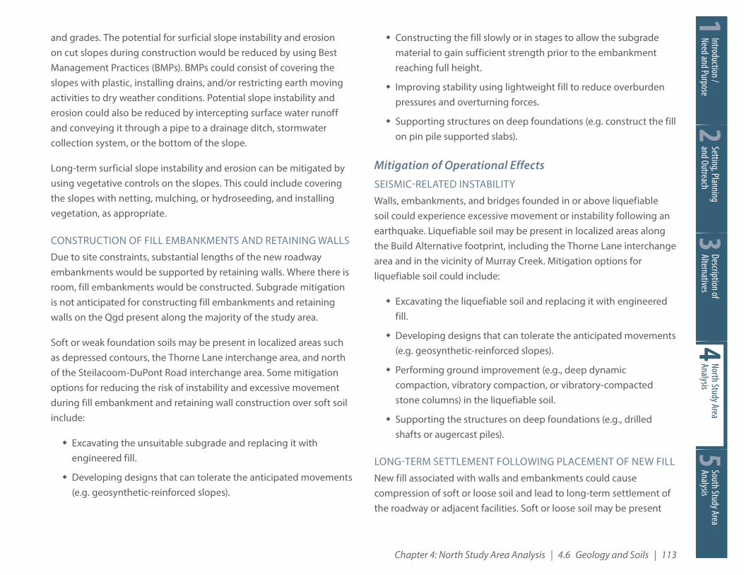
How Was the Study Area Defined? For the purposes of the geology and soils evaluation, the study area is defined as an approximately two-mile wide zone centered on the Build Alternative footprint (shown on Figure 4.6-1). The size of the study area was extended to two miles beyond the Build Alternative footprint to allow for discussions of seismic and volcanic hazards.
How Was the Geology and Soils Analysis Conducted?The nature and physical characteristics of the geology and soil units likely to be encountered in the study area were assessed through a literature review of available, existing site data and two field reconnaissance site visits.
LITERATURE REVIEW
Available site and historical information was obtained from geotechnical reports prepared by the project team, and information prepared by WSDOT, Pierce County Public Works and Utilities, and
the Washington Military Department. As-built plans for various existing structures along the corridor from WSDOT and water well logs from the U.S. Army Corps of Engineers were reviewed. Online interactive maps from the Washington State Department of Natural Resources, U.S. Geological Survey, and the Pierce County Critical Areas Atlas, as well as geologic maps from the U.S. Geological Survey were also reviewed. This information was used to characterize the area’s geology and to review potential geologic hazards in the study area. The information was also used to identify likely bridge foundation and retaining wall types for the purposes of assessing environmental impact.
FIELD RECONNAISSANCE
Geotechnical field reconnaissance site visits to observe the site conditions and exposed surface materials were conducted in June 2013 and August 2015. The field reconnaissance consisted of a windshield survey. Key areas where significant construction is planned were observed in more detail. In general, the surficial soils encountered at the key areas consisted of medium-dense to dense sand and gravel, except for in the forested area northwest of the intersection of Union Avenue and Thorne Lane. At this location, loose to medium dense surficial soil was encountered.
NOTE TO READER: This EA provides a tiered environmental review. Chapter 4 evaluates the project specific environmental impacts associated with construction of the North Study Area Build Alternative (See Section 3.4 for description). Chapter 5 provides a corridor level discussion of the South Study Area (See Section 3.5). Specific project footprint improvements are not currently defined for the South Study Area.

34
5De
scrip
tion o
fAl
tern
ative
sNo
rth St
udy A
rea
Analy
sis2Se
tting
, Plan
ning
an
d Out
reac
h1In
trodu
ction
/Ne
ed an
d Pur
pose
106 | I-5 JBLM Vicinity Congestion Relief Project Environmental Assessment
Sout
h Stu
dy A
rea
Analy
sis4.6.2 What Are the Existing Geology and Soils in the Study Area?
What Is the Topographic Setting?Most of the study area is relatively flat, with a few moderately sloped depressions and local hills. The alignment of I-5 within the Build Alternative footprint includes several cuts, up to about 20 feet high, excavated to construct the undercrossing interchanges at Gravelly Lake Drive, Thorne Lane, and Berkeley Street. I-5 crosses over 41st Division Drive and appears to be constructed on a fill embankment with 20 to 30 percent side slopes in the vicinity of the interchange. Several natural hills are located within JBLM south of I-5. Davis Hill, located just south of I-5, approximately between mileposts 120.1 and 120.6, rises about 80 feet higher than the I-5 roadway grade at a slope angle ranging between about 30 to 50 percent.
What Is the Regional Geologic Setting?Geologic maps show the study area to be underlain with glacially derived sediment deposited during the Pleistocene (Vashon Stade) Fraser glacial retreat that ended about 13,500 years ago. Glacially overridden deposits accumulated during the Vashon ice sheet advance and/or directly under the Vashon ice sheet. As the glacier receded, rivers flowed from the glacier and deposited thick layers of sand and gravel with cobbles and boulders, relatively free of silt and clay, at the study area.
What Are the Anticipated Geologic Units in the Study Area?The geologic units described herein are based on a review of the geologic maps and the historical subsurface information within the study area. Geologic units are interpretive and based on an evaluation of the soil types likely to be encountered during construction. Detailed descriptions and general geotechnical engineering
characteristics of the anticipated geologic units are provided in the Geology and Soils Technical Memorandum.
Figure 4.6-1 presents mapped surface geologic units developed based on the 1:100,000 scale geologic maps identified in our literature review. The majority of the study area is dominated by glacial drift (Qgd). Qgd generally consists of two components: Steilacoom gravel and Ablation till. Steilacoom gravel is comprised of sand and gravel, relatively free of silt and clay, with variable amounts of cobbles and boulders. Ablation till is comprised of silt, sand, gravel and clay with scattered cobbles and boulders. The thickness of the Qgd may range from several feet to 200 feet deep.
Glacial till (Qgt) is also mapped in the study area and shown on Figure 4.6-1. Qgt consists of silty sand with gravel and a trace of clay. Cobbles and boulders are commonly encountered at its upper geologic contact.
Several geologic units are not mapped on the 1:100,000 scale geologic map shown in Figure 4.6-1, but will likely be encountered in the study area during construction. Soft fine-grained sediment (Ql) and peat (Qp) deposits are anticipated near the Thorne Lane interchange (Exit 123) and near the Steilacoom–DuPont Road interchange (Exit 119). Potentially loose alluvium sand deposits (Qa) may be present in the vicinity of the Thorne Lane interchange (Exit 123) and in the vicinity of Murray Creek near I-5 Milepost 122.5. Man-made fill (Qf) may be encountered as engineered embankment fill within the I-5 right of way. Uncontrolled Qf may also be encountered anywhere within the study area.
What Are the Geologic Hazards Conditions?Potential geologic hazards that may affect the study area include volcanic events, landsliding, erosion, and seismic-related (earthquake) hazards. The following summarizes these hazards.

Chapter 4: North Study Area Analysis | 4.6 Geology and Soils | 107
34
5Description ofAlternatives
North Study Area Analysis
2Setting, Planning and Outreach
1Introduction /Need and Purpose
South Study AreaAnalysis
Qgd
Qgd
Qgd
Qgt
Qgt
Qgd
Qgt
Qgt
Qgt Qgt
&118
&116
&120
&119
&124
&125
&122
&123
LewisNorth
Mc
Joint Base Lewis-McChord
CampMurray
GravellyLake
AmericanLake
PugetSound
SequalitchewLake
DuPont
Lakewood
TillicumWoodbrook
Figure 4.6-1Mapped Surface Geology
I-5 JBLM Congestion Relief Study Environmental Assessment
N0 ½ 1¼
Miles
INTERCHANGESCenter Drive interchangeSteilacoom-DuPont Road interchangeMain Gate interchangeBerkeley Street interchangeThorne Lane interchangeGravelly Lake Drive interchangeBridgeport Way interchange
&118
&119
&120
&124
&125
&122
&123
Geology/Soils Study AreaBuild Alternative Footprint
GEOLOGIC UNITSQgd (Vashon Glacial Drift)Qgt (Glacial Till)
Figure 4.6-1Mapped Surface Geology

34
5De
scrip
tion o
fAl
tern
ative
sNo
rth St
udy A
rea
Analy
sis2Se
tting
, Plan
ning
an
d Out
reac
h1In
trodu
ction
/Ne
ed an
d Pur
pose
108 | I-5 JBLM Vicinity Congestion Relief Project Environmental Assessment
Sout
h Stu
dy A
rea
Analy
sisVOLCANIC HAZARDS
In general, volcanic geologic hazards include tephra (ejected material), lava flows, and lahar flows (volcanic debris and water). The closest active volcano is Mount Rainer, which is approximately 40 miles southeast of the site. Geologists estimate eruptive activity last occurred at Mount Rainier about 150 to 200 years ago. The volcanic eruptions led to debris avalanches and lahar flows down the White, Puyallup, and Nisqually rivers. More recent large lahars have occurred in the past 60 years, but these are limited to areas on the mountain. Based on the Washington State Interactive Geologic Map, the study area is not near tephra or lava flow hazard areas. Lahar flow inundation from volcanic activity at Mount Rainier could affect I-5 in the Nisqually River valley about three miles south of the study area. Based on the relatively long-recurrence interval for volcanic activity, and the estimated distances from the hazards, the risk of volcanic-induced geologic hazards at the site is considered relatively low.
LANDSLIDE HAZARDS
Landslides are movement of a rock and/or soil mass on a slope caused by shear failure within the rock and/or soil. Landslides can occur quickly or progressively over time, and can be either deep-seated or shallow. Potential causes that can increase the risk of landslides include: increasing water pressure in the rock and/or soil, increasing loading on or above the slope, removing material at the toe of the slope, and movement-induced weakening of glacially overridden clay.
Figure 4.6-2 presents mapped landslide hazard areas within the study area according to GIS databases developed by the Washington State Division of Geology and Earth Resources and the Pierce County Planning and Land Services (PALS). Many of the areas identified by the PALS GIS data set are man-made embankments and roadways, likely engineered for stability. Landslides have not been documented along
this stretch of I-5, including at the interchange embankments. The risk of landslide hazards at these locations is considered relatively low.
The mapped landslide hazard area associated with Davis Hill, located just east of I-5 between the Main Gate and Steilacoom-DuPont Road interchanges, corresponds to a location where cut slopes may be required as part of the Build Alternative. A geotechnical and geological assessment of these cuts will need to be performed at this location.
EROSION HAZARDS
Erosion hazard areas are those locations where the combination of slope and soil type makes the area susceptible to erosion by wind or water action. Water erosion can occur either by wave action, channel migration of rivers or streams, or surface runoff.
The vicinity of Murray Creek on the east side of I-5, just south of the Berkeley Street interchange, has been identified as a potential erosion hazard area.
SEISMICITY / GROUND SHAKING
The study area is in a moderately active seismic area that has been subjected to numerous earthquakes of low to moderate strength and occasionally to strong shocks during the brief 170-year seismic record in the Pacific Northwest. Some of the largest historical earthquakes in the Puget Sound lowland include the magnitude 7.1 Olympia earthquake of April 13, 1949, the magnitude 6.5 Seattle-Tacoma earthquake of April 29, 1965, and the magnitude 6.8 Nisqually earthquake of February 28, 2001. Geologic evidence indicates that a magnitude 9 earthquake on the Cascadia Subduction Zone occurred approximately three hundred years ago. This zone extends from northern California to the north end of Vancouver Island where

Chapter 4: North Study Area Analysis | 4.6 Geology and Soils | 109
34
5Description ofAlternatives
North Study Area Analysis
2Setting, Planning and Outreach
1Introduction /Need and Purpose
South Study AreaAnalysis
Source: Erosion Hazard and Landslide Hazard data published by PALS (Pierce County Planning and Land ServicesSource: Erosion Hazard and Landslide Hazard data published by PALS (Pierce County Planning and Land Services)
AmericanLake
LewisNorth
Mc
Joint Base Lewis-McChord
CampMurray
PugetSound
DuPont
Lakewood
TillicumWoodbrook
AmericanLake
GravellyLake
GravellyLakePuget
Sound
SequalitchewLake
SequalitchewLake
&118
&116
&124
&125
&120
&119
&122
&123
Figure 4.6-2Geologic Hazard Areas
I-5 JBLM Congestion Relief Study Environmental Assessment
N0 ½ 1¼
Miles
INTERCHANGESCenter Drive interchangeSteilacoom-DuPont Road interchangeMain Gate interchangeBerkeley Street interchangeThorne Lane interchangeGravelly Lake Drive interchangeBridgeport Way interchange
&118
&119
&120
&124
&125
&122
&123
Geology/Soils Study Area
Build Alternative Footprint
Erosion Hazard
Landslide Hazard*
* Data excludes some areas in JBLM and in city limits.
Figure 4.6-2Geologic Hazard Areas

34
5De
scrip
tion o
fAl
tern
ative
sNo
rth St
udy A
rea
Analy
sis2Se
tting
, Plan
ning
an
d Out
reac
h1In
trodu
ction
/Ne
ed an
d Pur
pose
110 | I-5 JBLM Vicinity Congestion Relief Project Environmental Assessment
Sout
h Stu
dy A
rea
Analy
sisthe Juan de Fuca tectonic plate is being subducted by the North American tectonic plate.
FAULT-RELATED GROUND RUPTURE
Based on the U.S. Geological Survey Fault and Folds Database and the Washington State Interactive Geologic Map, a known potentially active fault does not cross the study area. The closest known faults are the Olympia Structure, located approximately 11 miles southwest of the study area, and the Tacoma Fault Zone, located approximately nine miles northeast of the study area. Based on the fault locations, the risk of fault-related ground rupture at the site is considered low, and site-specific studies are not warranted.
LIQUEFACTION
Liquefaction is a phenomenon in which the strength and stiffness of a saturated soil is reduced by earthquake shaking or other rapid loading. As a result, ground settlement, lateral spreading, and landslides may occur.
Subsurface information indicates the study area is primarily underlain by medium-dense to very-dense sandy gravel (Qgd). This material typically is considered a low risk for liquefaction. However, Qa deposits, which could be susceptible to liquefaction, may be present in localized areas within the study area. Two potential locations include:
� The vicinity of Murray Creek (Milepost 122.5).
� The triangular-shaped, low-lying, wooded area north of the Thorne Lane interchange (Exit 123) between Thorne Lane, Spruce Street SW, and Union Avenue SW.
4.6.3 What Would Be the Impact of the No Build Alternative?The No Build Alternative assumes that I-5, associated connector roads, and overpasses within the study area will remain in their current configuration except for the funded improvements identified in Chapter 3. There would be no construction-related geology and soil impacts for the No Build Alternative. Day-to-day operational effects related to geology and soil associated with the No Build Alternative are also not anticipated. However, the existing overpass bridges and associated embankments and walls which would be replaced in the Build Alternative are aging and were not designed for the level of earthquake shaking specified by modern standards. Therefore, there would be a greater risk of loss of functionality to these facilities due to seismic-related damage in the No Build Alternative.
4.6.4 What Would Be the Long-Term Impact of the Build Alternative?Long-term geology and soil-related impacts could occur along the proposed new I-5 roadway and interchange modifications. The extent of these effects will depend on the final design and the mitigation alternatives implemented during construction to reduce these effects.
The Build Alternative will be designed based on the available and project-specific subsurface information collected, design procedures and criteria approved by WSDOT, and the site conditions as they exist at the time of design and construction. If subsurface conditions at the site are different from those discovered during field explorations, or if site conditions change during the life of the Build Alternative, future impacts to the site could occur. Long-term operational impacts are discussed below.
Seismic-Related Instability If a seismic (earthquake) event occurs during the life of the Build Alternative, the stability of structures, cut slopes, and fill

Chapter 4: North Study Area Analysis | 4.6 Geology and Soils | 111
34
5Description ofAlternatives
North Study Area Analysis
2Setting, Planning and Outreach
1Introduction /Need and Purpose
South Study AreaAnalysis
embankments and walls could be affected. The Build Alternative footprint is generally underlain by sandy gravel and gravelly sand (Qgd), which is not generally susceptible to liquefaction. However, soils that underlie localized portions of the Build Alternative may be susceptible to liquefaction during a seismic event. Possible locations where these conditions may be present include, but may not be limited to, the Thorne Lane interchange area and in the vicinity of Murray Creek. If liquefaction occurs beneath the proposed embankments and walls, slope instability and excessive settlement or landslides could damage the roadway and adjacent facilities.
Historic seismic performance of the bridges, cut slopes, embankment slopes, and retaining walls constructed within the WSDOT right of way in the study area has been good. Although the existing structures were constructed decades ago and according to less stringent standards than are in place today, they withstood the close proximity and magnitude of the 2001 Nisqually quake without impacts. This could suggest that new bridges, cut slopes, embankment slopes and retaining walls founded in Qgd soil in the study area are likely to perform similarly well, if not better, during seismic loading conditions if properly designed and constructed in accordance with current WSDOT and American Association of State Highway and Transportation Officials (AASHTO) criteria.
Long-Term Settlement Following Placement of New FillConstruction of new roads associated with the Build Alternative would require placement of new fill. Fill embankments and walls constructed over localized areas of soft compressible soil could experience long-term ground settlement.
Based on available subsurface data, the study area is generally underlain by sand and gravel or other very dense or hard soils. Settlement in these soils would be small and occur rapidly after the
fill is placed. Long-term settlements could occur in those areas where soft soil and peat are located. Soft soil and peat may be present at depressed contours within the Build Alternative footprint, in the Thorne Lane interchange area, and north of the Steilacoom-DuPont Road interchange area. If soft soil is present at these locations and not removed or mitigated by ground improvement, long-term settlement could occur.
4.6.5 What Would Be the Short-Term or Construction Impact of the Build Alternative?Anticipated short-term construction impacts would be primarily related to structure foundation construction, cuts into existing slopes, embankment and wall construction, and earth moving operations. Additional discussion and a detailed listing of the anticipated geology and soils related construction activities are provided in the Geology and Soils Technical Memorandum.
Structure Foundation ConstructionStructure foundations would most likely consist of spread or continuous footings since competent bearing soils are typically close to the ground surface. In some areas where space is limited, deep foundations may be used. Both shallow and deep foundation types would likely be founded in the Qgd or densely compacted man-made fill at the site. Structures should not be founded in the topsoil, soft sediments, or peat deposits.
Footing excavations require a significant amount of space, especially if mass excavation techniques are used. This can lead to the soil adjacent to the footings being disturbed.
Deep foundations, if constructed, would likely consist of drilled shafts, augercast piles, or driven pile foundations. Excavations for drilled shaft foundations could experience caving if not properly supported.

34
5De
scrip
tion o
fAl
tern
ative
sNo
rth St
udy A
rea
Analy
sis2Se
tting
, Plan
ning
an
d Out
reac
h1In
trodu
ction
/Ne
ed an
d Pur
pose
112 | I-5 JBLM Vicinity Congestion Relief Project Environmental Assessment
Sout
h Stu
dy A
rea
Analy
sisCaving of large diameter drilled shaft excavations could cause settlement or damage to nearby structures.
Cuts into Existing SlopesConstruction may require cuts into existing slopes to allow for widening of embankments and construction of drainage ditches and culverts. During construction, soil exposed in slope excavations may be susceptible to erosion until vegetation is established. Cuts into slopes for roadway and culvert construction could result in shallow landslides and sloughing. The higher the cut slope, the more prone the slope is to failure and the greater the potential impact. Failure of higher slopes could result in greater volumes of failed material, which could block drainages or be eroded and conveyed to streams.
Construction of Fill Embankments and Retaining WallsConstruction impacts due to fill embankment and retaining wall construction typically involve slope instability and settlement. The study area is generally underlain by medium dense to dense sands and gravels (Qgd). Fill embankment and retaining wall construction on these deposits will likely have a low risk of slope instability and result in relatively small settlements which should occur rapidly with little long-term impact on roadway operations.
Soft or weak foundation soils may be present in localized areas such as depressed contours, in the vicinity of the Thorne Lane interchange, and north of the Steilacoom-DuPont Road interchange. Fill embankments and walls placed in areas where soft soil is present could lead to global instability if not properly designed and constructed. Soft foundation soil has low initial strength but gains strength with time when loaded. Therefore failures could occur during construction if fill is placed too quickly over soft soil. Walls constructed on soft or loose soil may also experience excessive
settlement and/or differential settlement at locations where soft soil transitions to more competent soil.
Import or Export of SoilConstruction activities could require the import or export of soil from one portion of the site to another or outside of the study area all together. A listing of activities that may result in import or export of soils is provided in the Geology and Soils Technical Memorandum.
4.6.6 How Can Impacts of the Build Alternative Be Minimized or Mitigated?
Mitigation of Construction EffectsSTRUCTURE FOUNDATION CONSTRUCTION
Construction of spread or continuous footing foundations for bridge and overpass structures would require excavations. The extent of excavation for footings can be reduced using temporary shoring walls. These walls could consist of drilled soldier piles with lagging. Shored excavations for foundation construction within the study area will likely be shallow enough that anchors or tiebacks would not be necessary.
To avoid adverse settlement of footing backfill material, the backfill should be constructed using thin lifts of relatively clean sand and gravel placed and compacted in accordance with WSDOT specifications.
If drilled shafts are used for structure foundations, caving-prone granular soil may be a risk. To mitigate this risk, temporary casing should be implemented during construction.
CUTS INTO EXISTING SLOPES
To mitigate the risk of deep-seated slope instability (landslides), temporary and permanent cut slopes should be limited in their height
Chapter 4: North Study Area Analysis | 4.6 Geology and Soils | 113
34
5Description ofAlternatives
North Study Area Analysis
2Setting, Planning and Outreach
1Introduction /Need and Purpose
South Study AreaAnalysis
and grades. The potential for surficial slope instability and erosion on cut slopes during construction would be reduced by using Best Management Practices (BMPs). BMPs could consist of covering the slopes with plastic, installing drains, and/or restricting earth moving activities to dry weather conditions. Potential slope instability and erosion could also be reduced by intercepting surface water runoff and conveying it through a pipe to a drainage ditch, stormwater collection system, or the bottom of the slope.
Long-term surficial slope instability and erosion can be mitigated by using vegetative controls on the slopes. This could include covering the slopes with netting, mulching, or hydroseeding, and installing vegetation, as appropriate.
CONSTRUCTION OF FILL EMBANKMENTS AND RETAINING WALLS
Due to site constraints, substantial lengths of the new roadway embankments would be supported by retaining walls. Where there is room, fill embankments would be constructed. Subgrade mitigation is not anticipated for constructing fill embankments and retaining walls on the Qgd present along the majority of the study area.
Soft or weak foundation soils may be present in localized areas such as depressed contours, the Thorne Lane interchange area, and north of the Steilacoom-DuPont Road interchange area. Some mitigation options for reducing the risk of instability and excessive movement during fill embankment and retaining wall construction over soft soil include:
� Excavating the unsuitable subgrade and replacing it with engineered fill.
� Developing designs that can tolerate the anticipated movements (e.g. geosynthetic-reinforced slopes).
� Constructing the fill slowly or in stages to allow the subgrade material to gain sufficient strength prior to the embankment reaching full height.
� Improving stability using lightweight fill to reduce overburden pressures and overturning forces.
� Supporting structures on deep foundations (e.g. construct the fill on pin pile supported slabs).
Mitigation of Operational EffectsSEISMIC-RELATED INSTABILITY
Walls, embankments, and bridges founded in or above liquefiable soil could experience excessive movement or instability following an earthquake. Liquefiable soil may be present in localized areas along the Build Alternative footprint, including the Thorne Lane interchange area and in the vicinity of Murray Creek. Mitigation options for liquefiable soil could include:
� Excavating the liquefiable soil and replacing it with engineered fill.
� Developing designs that can tolerate the anticipated movements (e.g. geosynthetic-reinforced slopes).
� Performing ground improvement (e.g., deep dynamic compaction, vibratory compaction, or vibratory-compacted stone columns) in the liquefiable soil.
� Supporting the structures on deep foundations (e.g., drilled shafts or augercast piles).
LONG-TERM SETTLEMENT FOLLOWING PLACEMENT OF NEW FILL
New fill associated with walls and embankments could cause compression of soft or loose soil and lead to long-term settlement of the roadway or adjacent facilities. Soft or loose soil may be present

34
5De
scrip
tion o
fAl
tern
ative
sNo
rth St
udy A
rea
Analy
sis2Se
tting
, Plan
ning
an
d Out
reac
h1In
trodu
ction
/Ne
ed an
d Pur
pose
114 | I-5 JBLM Vicinity Congestion Relief Project Environmental Assessment
Sout
h Stu
dy A
rea
Analy
sisin localized areas along the Build Alternative footprint, including such locations as depressed contours, the Thorne Lane interchange area, and north of the Steilacoom-DuPont Road interchange area. Mitigation of long-term settlement associated with the compression of soft or loose soil could include:
� Excavating unsuitable subgrade and replacing it with engineered fill.
� Developing designs that can tolerate the anticipated movement (e.g. geosynthetic-reinforced slopes).
� Preloading (i.e., over-building the embankment with a higher fill height than necessary, leaving this over-built embankment in place for a period of time during construction to increase the rate of settlement, and then removing the excess fill prior to paving).
� Lightweight fill material in lieu of heavier granular fill to reduce stress on the underlying soils.
� Installing a grid system of wick drains within soft soil to promote faster consolidation settlement.
� Performing ground improvement (e.g., vibratory-compacted stone columns) to densify the soft or loose soil.
� Supporting the structures on deep foundations (e.g., drilled shafts or augercast piles).
Additional MitigationEROSION
Erosion by surface water runoff and wind (including the generation of airborne dust during construction) would be an ongoing construction issue. Consideration should be given to limiting earthwork operations to the drier times of the year when erosion potential is reduced. Another option to reduce erosion potential is limiting the acreage of newly exposed soil. This can be accomplished by careful planning of construction staging and by the use of geomembrane covers.
Wind erosion can occur if soil is exposed and allowed to dry. If earthwork operations are performed during the dry season, applying water to newly exposed soils can be an effective method to mitigate wind erosion of dry soil. If the soil remains moist, it is less likely to be eroded by wind during typical construction operations.
Stockpile and waste sites within the Build Alternative footprint would require erosion mitigation methods and techniques similar to those described above. Potential for erosion during construction operations would be replaced by following the BMPs outlined in the Temporary Erosion and Sediment Control (TESC) Plan sections of WSDOT’s Highway Runoff Manual and Environmental Procedures Manual.
STRUCTURAL FOUNDATION EXCAVATION
Structural foundation excavation material stored on-site would require erosion mitigation methods and techniques similar to those described in the Erosion subsection above.
4.6.7 Would There Be Any Unavoidable Adverse Impacts from the Build Alternative?Risks posed by construction of the Build Alternative can be avoided through design and controlled through the mitigations identified in the previous subsection. Therefore, no unavoidable direct or indirect adverse effects are expected for the geology and soils resources. However, some earthwork traffic on roads and highways during construction of the Build Alternative cannot be avoided. Using on-site material from cuts and foundation excavations to construct embankments would reduce the potential impacts of earthwork traffic on public streets. The amount of new fill required for the Build Alternative would likely be greater than the volume of material removed in excavations and soil cuts. Therefore, material will likely need to be imported.