Embed Size (px)
Citation preview
'c" ,/ 3 KOLT4AKO F CI NHARAR PRO SPE CT "'
VESTERN ALASKA HI PKIPlCs COWPATE
AHIAK f RECIfLt CT'
KUSKOXWXM RXGIOM, ALASKA
by
MARTIN W. JASPER
Associate Yinfng Englneer
May - 1955
Page
Sampling
APPENDED
Haps No. 1 an8 No. 2
P l o t u r e s of Area - Plates 1 t o 2 f~ncl.)
R~PR-mNCZS
U.S. Bureau of Mines R.1. 4065. pages 49-50
1r.s.o.s. nulletin 622. Pages 273-4, 280 to 286
Mi story:- Ivan Betrovts Report on Population, 'I ndustrles and Re souroes of Alaska I$&, Pages 13, 7 T 1 and 90. F f r e e M e n t i ~ n .
9. E. Spurr, U. S. G. B. 20th Annual Repor%, P a r t 7, Page 261, 1900.
The Kolmakof cinnabar occurrenee f s possibly the f i r s t one noted by the Hussiz%ns, i n the 18008s. ~l
Although known fop 75 to a 100 yeasa, the LSmf ted am- ount of explorat i~n work Bone upon iG kas been unsuccess- ful. to date in determfnf ng theyesenoa of o r e bodies of economf c interest.
Dozer st~1pping 3n August and September 1954 uncovered a lense 24 feet in length, which carried fair values across 22 t o 51 fnoh widths in &eared shales on hang- ingwall 8fde sf a mrrov rhyolite ~911. No o t h e r point s of minera l i za t ion were noted in the 125 feet of strbppfng along the strike of the t h f n s i l l . An *u to Zfl eknnabar stringer, s%riking to northwest, was uncovered and follow- ed for 25 f e e t in the overlying sandstone.
It was reported May 9th, 1955 that a winze, sunk last month t o depth of 10 feet , found no cinnabar rnineraliz- athon belaw the 2 foot l e v e l .
* References: U. 2.d. 8. BUT. 622. P~ .ges 2g0-286
U.S.B.14,R.I. 4-065. Pages 48-4-9
A t request of M, J. Anderson & Assocfa tes (a partner- ship known as the Western Alaska Mining Company (VAMCO) ) t o examine the prospeot an8 lay-out a dozer stripping program on the Kolmakof c i n n a b ~ ~ r p p e r t y which they had recently located, t k a period. f om Augu~it 28 t o September 3 , 1954 was spent on that pro jec t ,
A 3 1 018 workings and the dozer c u t s were t ied- in by Brunton- tape traverse, and are shown on Rap6 1 & 2 attached.
Following t h e mapping of the area l o c a t i o n s %or additional doze^ ~Lripping Zn Beptember was laid out.
Located on a 250 f o o t b l u f f on n o r t h s i d e o f t he Kuskokwln RZver at extreme westem limits of the river in the Bleft- ra~rte qttstdrang'ls, Aniak P rec inc t , it lies about f m i l s eaat of gesgraphi eal soor8inats Long1 tuds ~ 5 9 ~ OQ ?, , and Lati tude 6xo 361. It is, approximately 20 mlEaa tipstream from WnZak, an& 38 aslea aownstrem from the o l d Kolrnakof F o r t ru ins .
'It f s accessible by d a i l y soheduled Northern CSonsolidate~ A i r l i n e s planes f ~ o m fmohorage to Anfak and Bethel. F r ~ m Aniak t o t h e property an outboard motorboat was used. F l ~ a t squfpped planes can 'Land on $he Kusk~wim River with- in 500 feet of the showings.
The property is about 200 miles from mouth of the Kuskokwfm River, and aboue 140 miles above Bethel.
Heavy f re ight shipments i n t o the region are handled by f iver boaes from Bethel, where 2t i n delivered by stearn- ships from Seattle.
This imrnediaee area on north side of t he river i s one of l o w relief, with a general ly ro l lhng surface graduaZ1y rbsing t o 1000 to 2000 feet above sea Level. ElevaLlon of the river, below tire showings, is w i t h i n l i m i t s of 150 to 200 fee t ,* an6 the skawing~ axmined are 250 f e e t above e t .
" The rtostlz ban% of the Kuakokwim PUtTer f s metda up chie9l.y of rock blaf f s f r o m 100 to 4-00 f ~ e t hfghu. *To the south of the r i v e r the area is one of a wide alluvial. lowInn6 valley,
The r l v e r e width %n th i s v ic in%ty i e % to 3/4 mile.
Cnlg smttared scrub spruae 3.8 t o be found on the property. Howaver, there is rn abundanoe of spruce su i t ab l e for mining timber aria lumber a l ~ n g the river va l ley wi th in a few mf Jes ~f the property. Birch an8 poplwr 1% abundant, w i t h some biroh nofefi of good size,
Xn the area on north side of the river the underlmah g ~ o w t k ~ E I notheavy ant3 affs~s easy travel acrofis the country on foot; and % o r tssctcsr travel, The slopes have a f a i s l y heavy Glass covering, and pema f r o st x4as f ~ u n a in some of the auta f o r a f e w f e e t en th i ckness under the tundra,
A small ~Greaa, intrenahed In a f a u l t plane, is present on the property; it 1-les 500 t o 1300 feet north of the bluff showings In wes% ha l f , and piz~&tll@Is the bluf f edge at 1 C O t o 200 feet i n eas$ half of mapped area.$'* The stream flow ~ r o u l a be sufi ioienrt fur camp use.
H% STORY AND Bb~H!tRSI-ISP
The Kolmizlaof cinnabar o ccurrenee was known $0 the Russians long befose J. E, 5purr1 s referenee to it in 1698.***
During h i s recannaiasaace of the Kuslrowlm region that year Spurg. rnemz2lion~ that a tmfisr, Mr. EinB, hail. found a cinnabar veln several years before on the Kolrnakof property, ma that Eind hati epent $2QBO.OO mining some of the are, whieh was shipped t o the g t a t e s at a loss.*%** He v i s i t ed the property but did no t note the small excavstisns along the bluff slopes.
A.G. Haddren, In 1914, a180 found %hat the clnnabwr in- a i ca t ions were ob~cure , a1$klough u o ~ k w a s P epor2;ed t o have been done on %he occusrenees since t h a t of' Mr. Lind.%****
A Mr. Rabiaeau is repsrtted to have he318 the ground f o r many years and t h a t a aaafl mount of quickaflves was *u. 5.a. 3. R u ~ . 622. Pages 260-81 *+Map 1, attached. *%9
9.8.8, Twentieth -Annual Report, P a r t 7. Page 261,1900. *Vlu
U. S.G, 5. 3ul. 622. Page 273, 1914. a$*%= % J. B.G.s. ~ u l . 622. Page 274.
proitaced in a homemade retort at h i s home a mile or so downstream on south bank of the Kuskokwim river, It is no% clear when he or othere put dam the two o l d o~fnzes; orme of these is locates 75 feel; from bluff' eage (vertical and of undetermlnea depth), an# the other 675 f e e t t o nor theas t , sunk on a 500 to 60 slope and said to be $0 feet fn depth, although the dump i n d b t e s it Go be much shallower. The first noted winze was largely dese~oyed by dozer cut No. 3-CT, a short time before the 3954 ex- emination, an& QRa other w a s f i l l e d with water,#
The property was opgioned o r ~ a l o c a t e d I ? ) in 1907 or 199$, by Gardon R e t t l e s of IVome an& the B e t t l e c ad i t was driven an undetsrrninefi distance.
The p r o p e ~ t y w a s held by :#SlLie Rabideau, son of t h e old- %2mer, f o r a number of years, prior to 1953.
The property wzis re loca ted in 1954 by the IJAMCO group.
The f o r ~ a t l o n in v i c i a i t y o f the Kolmakof prospect is 11~9te6 t o sandstone ( a ~ k o s i c and quartzose) and shale, which are well-expoee8 f o r the n o ~ t part half way up the b lu f f . These Interbeddeb skafments are of tbicknece, and are classed as upper cretwseous Treat or lower %ert is ry) slmZbar to o t h e r sec t iona of Xuskokwim region. The sw.n,dstone beds k ~ . v s the greater w i d i ? k ~ , varyfng from s Pew f e e t up %o 20 feet or more in thickness, while the shales q p a a r to range f rom thin layers to 2 t o 5 foot thick.%"
A number of 81lj-6 have been reporLed in the 8%st r i c t . S t r i k e of the eeaiments l o c a l l y Pnnges from ~ 4 5 ' %a 75% and t h e i r dip v8,ries from IDo to 600 N??.&"*
Two rhyolite s i l l s , ( Ident i f ie& ae andesita by 13.3. G. 33, are known to be present ; the westerly one exposed an8 ToLZoued 125 feet In cut No. h - f : ~ , and one showing in bluff below but n o t exposed in cut go. 3-CT 250 f ee t east. The first notea s i l l varies in width from 2 to 5 Fee% where s t r ipped in the cut ; St 9 s obscursa by the bank Iiareepir t o l a rge extent on the steep bluf f slope. The second w i l l Xs also l a r g e l y obtinared, but is repar ted
4*Refer to Rap 1. **U.S.G.8. Sul. 622, Pege 283-g&,- Refer to Map 2, attached. +b98,f!.G.s. Bur. o f ?::ines. R,I. 4065, Page 50, Fig. 21.
t o be 1 to 2 feet thick."
During course of susveylng and mapping in 1954 p l o t t i n g of the 8 trenches s%ilL in evlbence on bluff slope ex- cava.t;ed by U.S. 2urv~au 02 F?.f%~es in l94k indictates their
-along w 5 to 30 f o o t ~5612 4iew and shown on t h e i r F igu re 21,s" and b a the same narrow sill. uncover- ed in cut PJo+ lf-ST. However, its true ~7IdZ;h on the elope wae a l s o l a r g e l y obmred by bank HcreepsH and by the material pushed over the b lu f f edge by the doze^.
s,long the shale beading ( o n hangirig-%:all. s ide was no te6 I n No. ~ C T cut, s.nd two f z .ul ts a re
shown a.t w e s t enci of 'ehls same
Several, f e e t of glacial c lay was present i n number of t h e 1954 dozer cuts; *he r e s i d u a l weathesing of the sed1- m e n t ~ extends f r o m 5 to 1% feet below the c l a y , especeally near the b l u f f eci.ge.
The ainnabar ~ l n e ~ ~ ~ l i ~ & t l o n , as e l eewhere in t h e Kusko- k w i m reg ion , i s associate& with and f o l l o ~ ~ e f l . the i n t r u s i o n of s i b b ~ . tdith the tT. $5. Bureau of Nines 194-4 trenohea sloughed-in and in number of cases obscured by ticreep" of t h e steep bluff slope, and the Set t les a d i t an6. old winma inaccessible, obse~vat$ans o f the mineral occur- rences were Zimftea to the showing exnosed by dozes tranch- i ng i n l954.
Due t o i nexpe r i ence of the owners and the con t rec to r dofng the stripping, trenching done p r i o r to the examining engi- neers arrival. on the prooper4;y had n o t located the s i l l on top of the bluff which t h e 1T.S. Rureau of Wines had traced. on the slope below. Cut go. 4-CT was then l a i d out and t h e s i l l with game good c2nnabar values i n its hanging- w a l l shale was uncovered w f t h f n an hour and a ha l f ,
Vi th overburfien dep th along s t r ike of s i l l rzngf ng from 10 f e e t on east end t o f e e t on w e s t side of t h i s out, and perma f ros t present at n o r t h s i d e , four days were re- q u i r e 3 t o ~ t r Z p 125 f e e * and remove 3500 cubic yards to the bluff edge.
* U+S.GoSo ~ u l . 6 2 2 , Page 283-$4. Refer t o ?Jag P r attached.
++*TJ.S. UP. 02 Mines. R.I. 4065, Page 50, Fig. 21. w* Refar t o I4a.p 2, a.ttacbec?.
In s t ~ i p p l n g the 125 feet along %be sfll from east to west a short lense, 24- f ee t in length and carrying goo& values was exposed in t h e sha.le on hanging-wall of the narrow ( 2 t o 5 feet) 93.11. Zt was notien that in cutting dawn t h e zone 1* t o 2 feet to expose more so l id . bedrock, the dozer g o t dstm below Sfrn3.e~ o f mineraliza*lon s* the east end. f o r l e n g t h o f about 5 f e e t 2nd- exposed an approximately equal length of mineralf za t lon on the west end," Thhls suggested the shop% QT~-shoa t t o hzve very limetea vertical range and flplungedfi at small angle t o t h e west.
The cfnnabar occurs a s small i@podstl o r bunches, 3,s shor t d l scontinusus ve in l e t s , and as "blebsi{ an& disseminated g r a i n s in 3 s t r o n g l y sheared shale. No o the r su l f i de s were no%ed to be present. R IZttle ca lc i te was observed at a few p o t n t s .
The narrow s i l l is veil f rac tu red but no c innaba r wag noted in 1% throughout %Ls exposed length.
A cross-fracture, having a 1x62~ s t r i k e and 50' t o 55' south dip, was uncovered in t h e Izanglng-wall sandstone, T h i s w z s Lraced 3O f e e t a n d 1s f i l l e d with t o 1 i n o h ot" " s o f t H (weathered) cinnabar, w i t h no 0 t h ~ ~ s u l f i d e s noted. The inch o r two of gouge-like materfal a long the ~ra l l s f s probably due to hydrothema1 al$eratIon sf the arkosic s ~ n d s t o n e as no f a u l t movement 1s evi- den t along t h i s fraczure plane. Bts%pphng t o the north- west encountered f r o z e n grauna so tha t it was n o t deter- mined whether the s t r i n g e r c o n t i n u e d beyond p o i n t shown an Hap 2 , a l though i nd i ca t i ons at t h a t time sugp:ested It; did no t .
The only o t h e r I n d i c s t l o n ~ o f clnnabas minera ' l izatlon %xaa found I n cut; Mo. 3-CT; t h i s t r e n c h IWE: completed before date of v i s i t .
~ P Z S dozen o r more pieces - I to 3 i n chee i n diameter - were foun8. in west b ~ n k 09 cat a few feet above bedrock. Depth a% clay and. residv,alf_y weathered shale^ and a.rko- & l a sand.%tone at th9s po in t IF-: 18 feet. I? few piece8 of sirn3.la.r sLze piem reporte t i found on ( o r $133) bedrock, a l t h o u g h on examina t i~a of t he cuts f l o o r no cinnabar tvas obsertre3, En clnnabzs was noted I r a Bum? n i ~. r inze on east s i d e of cut Nu. 3-CT; i t 1 s possible t h , a t eny o re encsunteuped %%:as cmrefvl9 3~ sorted. c l tz t snB r e to r t e8 by t h e miner who sunk the F T ~ P ~ Z ~ .
* Refer to Map 2 , attached,
No cinnabar was n o t e d i n dump of t h e I n c l i n e d winze 650 f e e t t o northeast, a l t h o u g h 0.166 Ags. was o b t a i n e d in a n g ~ a b n sample. I f any o r e was found d u r i n g course of that work it may also have been sorted and r e t o r t e d .
A11 o l d trenches known by p r e s e n t owners were checked and no c i n n a b a r observed in t h e i r dumns. None of t he material ~ernoverj from t h e We t t l e s a d i t remains on the bluff slope; i t hae been removed d u r i n g periofls of hlgh w a t e ~ o ~ ~ ~ i c e - j a m a ~ ~ and washe6 into the r i v e r .
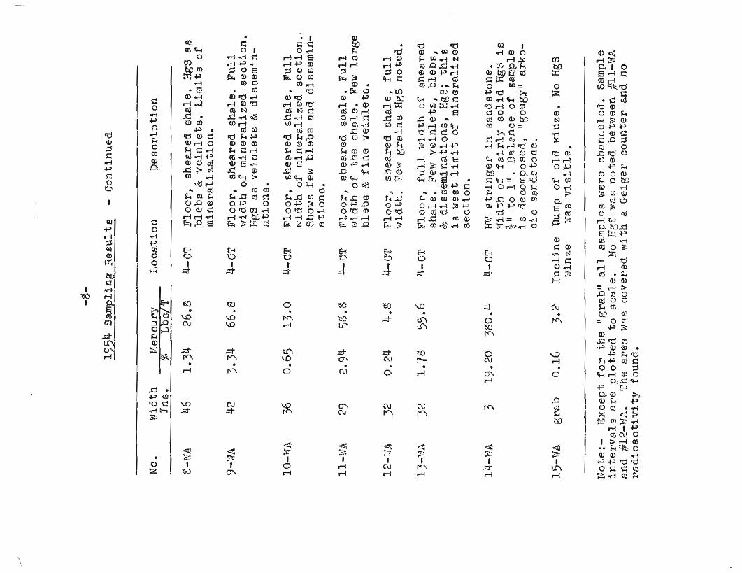
F o u r t e e n channel samples Were taken of t h e s h o r t lense In cut No. 4-CT and one grab sample of the i n o l i n e d shaf t dump. qescription of these are aa follows and Locatione shown on Map 1, attached:-
1954 Sampling R e e u l t s
No. Width Mercury L o c a t i o n nesc r ip t ion In&. % Lbs/T
3, - ? f ~ 24 0.3g 7.6 k-CT F l o o r of cut . $headred shale. I r reg. "blebsn B few P i n e v e i n l e t s FTg9,
2-?MA 22 1.78 15.6 4-CT F l o o r , s h e ~ r e d shale. NgS a s tiisemminat%ons & f i n e ~ h o r t veinlets.
3-~JA 24 8.1C6 269.6 it--CT F l o o r , sheared shale. No H g 8 noted In 15" on FW sf de. 9" nra HU ~ Z d e composed. of small l ense and f e w stringers.
4- Wp, - 24. 0.3g 7-6 ~ C T F l o o r , sheared shale. Con- tPnuation o f sample 3-%A on
slde. %?o fine vein1 e t s znd B i t t l e 8f twgem. 19~1.
5 ->;A 2 1 3.47 4-CT Floor , shearea shale, Full width o f main mineralized sec- Lion next to s f l l . HgS as b l - eb~ & veinlets.
6-sir& 30 0.gl 26.2 b-CF Floor , shearea shale. Contin- u a t i o n nf 5-t+rR on FJIq side. Few blebs & 1.ittl .e f i n e grain- e d diseminated MgS.
7 -fdA 24 S.I~ 23,s 4-6T F l o o r sheared shale. Blebs and f i n e v e i n l e t s .
( Gcsntinued next page)
CQN CLU SIOMS
F ~ o m work done and resu19;s sbtainea a long the s i l l by the U , 9 . 3aareau of Milsee in I94iC mr_t by the present owners e t rhp- p ing program in 1954, no enootrraging etriG.ence has been found t h a t would i n a f cate a i t fair chanceH o f Locatlng ore-shoota o r !~%ner2!-S_zef4. zones of econornic Impostanoe 4-n this v lc i r t i t y ,
Thc o r e Qccursenaes found By $he TI .B .R ,W. in t h e i r t renching were f s o l a t e $ small. t lpods", a t k f n ve3.n?_et along a f e w frac- tures ac rocs t h e s i l l , s s l i $h t l y lnineralbzed 2 f o o t wide stlear zone a long the s5.21,~ rc"ooo;arelf_, and rj narraow (average r l r j t h 4 Znch) ~ e ~ . a l sterr% h$ghgrada cimna,bar s t r inger traaed. by trenches a t interval^ 250 feet up t h e elope f o r v e r t i c a l 3ftstance o f 100 f e a t , T h i s l a t t e r o f f e r a poacitb3ll. tg of a very s m s L l tonnage, x b i 2 e the o t h e r occurrences in mining widths vou28 be t o n l o w gritc1.e.
The ore-shoot exposed f a r l eng th of 2k f e e t and wddth of 22 t o 51 i n c h ~ s 1.n c u t No. 4-CT has goo& values b u t is an iso- ha te6 occurrence bel.ieved to have a shallow depth. T h i s was inaicated in fieepcnl.ng t h i s cut v&~icts. P n 2 f e e t reached the bot tom and removed 5 f s e t of ' ch i~Y%lense . BddZtiana3. proof of its probable sha2loxmess was obtalned during April 1955, wken a winze was sunk on the htghest grade sec t fon t o d e ~ C h of 1.9 fee t ; tl-ie rn2ner reported l a s t v:eek t h a t no values were r"ortnr1 Frorn point 2 f e e t ba5,ow ssurface t o bottom o f t h e WLnze.
Elozt~fng 09 T n t e r e a t was fotlnfi i n t Re o t h e r t;rexlches uxcava%e8 by dozer l a s t year psion. t o 'Wee of e x m i n a t i o n (:ate; unusual- 2-y wet vesther mwae t h e ave r ly ing cl3.y and residua/ly weather- ed bedrock lmprac%ical to remove Go s o l i d bedrock except at bluff en4 of' cu-t; KO. 3-CT. Cut R T ~ . g-CT W B S n u t coml;5leted l a t e r in 3eptember 4ue to perma fmst at ttpner end sntl soft- ness 0% ground at sou th end.
0.c FxsmSne,,tiori sf the olCf winze autunpe shows nathin@,aufficlent e+ in . te res t to encourage aari?4_itiona3L wcrk i n "chat sec t ion .
Prom surface i n a l c a t f o n c as well as bedroclc cxpoalnrefi in c u t Eo. 3-3'2 there atlpesrs to b e rac gust9.11ca.t5_on :for clean- %ng o u t andl sxaminlng the abd. 13etblea ~ d . l t .
1, Sink winze to 20 t o 3Cr f c ~ t depth at 2oc3atioil raerked on gap 2 , in c u t ?.lo. 4-CT. 750ulB goad vslues can t inue to that
d e p t h , 4 r i f t t o west an5 e a s t $0 determine I l r n t t s and va.fues o f l s n ~ e (ore -shoot ) . 5halaId va7.ues and lencth of Zenee j u s 2 ; i . f ~ ~ s ink an addi- tional ?O $0 30 f e e t , an? 4rLft to west an8 east. Abandon g roJec t If tin,-jabar mins ra l i z a tZon S E bottorneEb in f i r s t ~ e c t j - o n of xr~lnee.
?. 14a.ke dozer cut ~ s . 3-CT s l a n g line marke6 on the ground t o bedrock. T h i s will cross-cut both dikes. Tf no values sre found there wlll he no g u s t i f i c a t l o n f o r a 4 d i t l o n s t c u t s para l le l t 2t to the nor theas t ; should
ci& good vnlues be found etrip J t r i k e dP m i n e r a l i ~ , e d zone bs encounterei t , anta/or ma'xb addi'tiono.1 parallel c u t s ,
F'avorab$e r e su l t fi from t h i s woark 7:.27,'J_ determine f u t u r e Dragsam t o f 0 2 l . o ~ .
?<ar t in ?I. ~ U f e r A ~ s o c l a , t e IISbralng Rngineer
TerritorSs.3. lfepartment of Mines
Anc_horae;e, A l z ska Xay 12, 1955
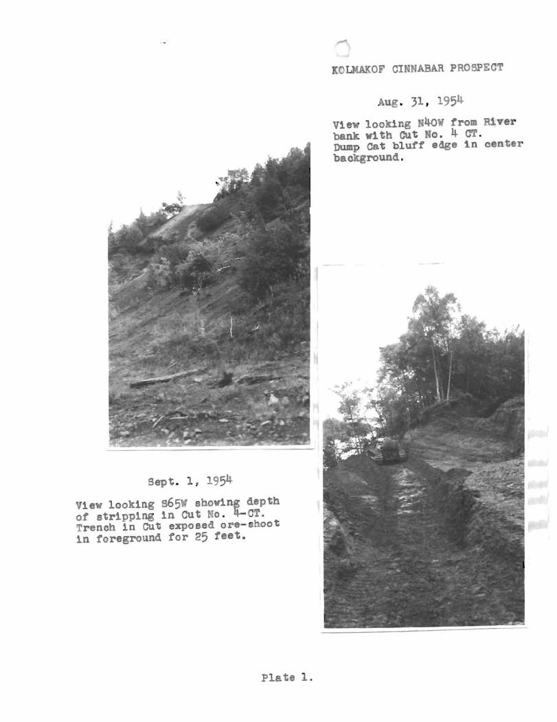
Kr't;MA??OF CINNABAR PROSPECT
View looking ~ 4 0 ~ from River bank with Cut No, 4 CT. Dump Cat bluff edge In center background.
View looking 965a shoving depth of stripping In Cut Po. J-ST. "ench in Cut exposed ore-shoot in foreground f o r 25 feet .
P la te 1.
- A-
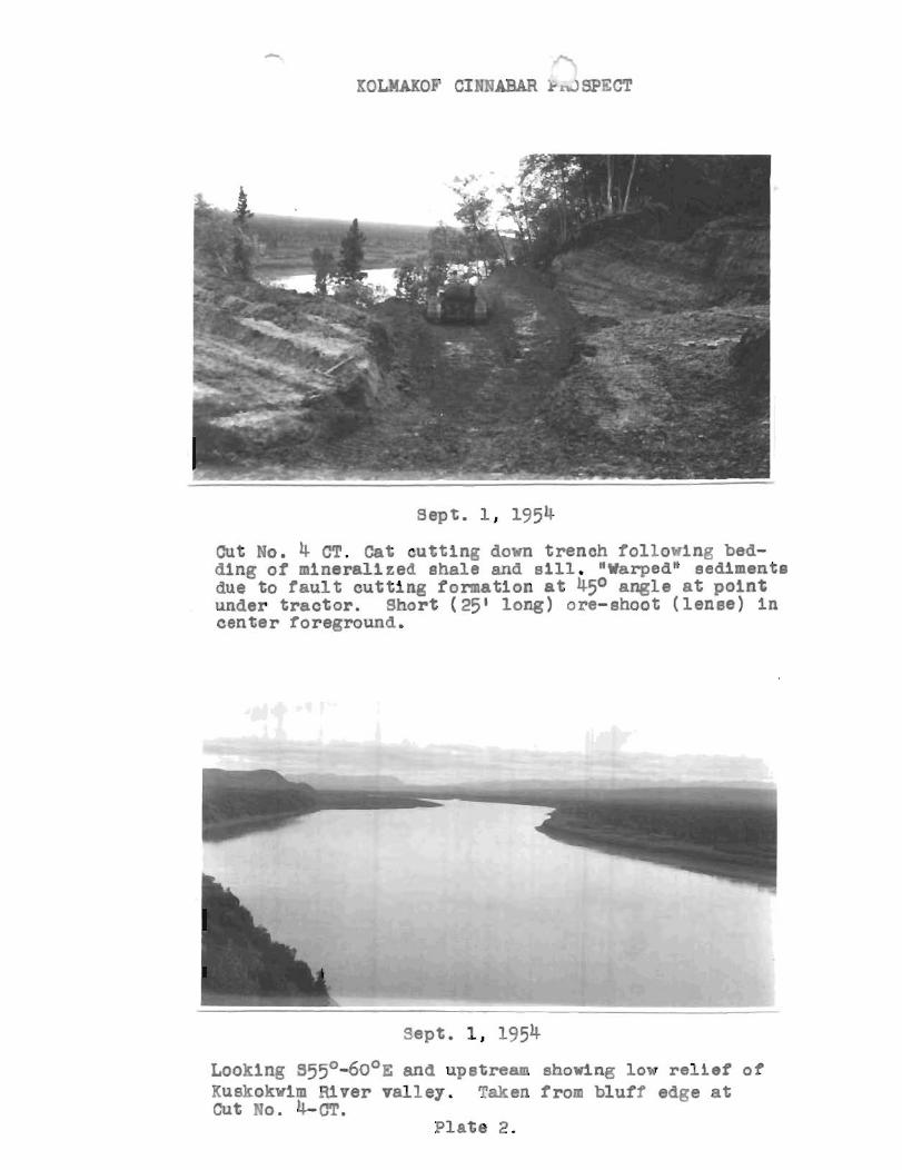
KOLMAKOF CIMNABAR k nJ SPECT
Cut No. 4 CT. Cat c u t t i n g down t r ench io l lowlng bed- ding of mineral ized ahale and slll. WarpedN sedlmenta due t o f a u l t c u t t i n g formation a t 45O angle at p o i n t under t r a c t o r . Short ( 25' long) ore-shoot ( lense) I n cen te r foreground.
Looklng ~ 5 5 O - 6 0 ~ ~ and upstream shorlng low r e l i e f of Yuskokwirn a v e r valley. Taken from blufY edae a t Cut L C T .
Plate 2.


![La Hierba and Rhyolite LVU Facilities Seepage Analyses R3[1]](https://img.pdfslide.net/doc/110x75/577ce7c61a28abf10395bbfa/la-hierba-and-rhyolite-lvu-facilities-seepage-analyses-r31.jpg)