Embed Size (px)
Citation preview
Simandou SEIA Volume I Mine Chapter 5: Geology, Soils and Mineral Waste
5-1
5 Geology, Soils and Mineral Waste 5.1 Introduction This chapter presents an assessment of the potential impacts of the construction and operation of the Simandou Mine on geological and soil resources and land capability. The assessment considers the following types of impacts: damage to soils as a result of changes in geochemical conditions; loss and physical damage to soils during mine construction and operation; disruption of soils as a result of extraction and deposit of material during construction (from borrow pits
and disposal of construction spoil); and contamination of soils. As discussed below, a range of other impacts potentially relevant to geology soils have been identified but are either covered by other chapters of this SEIA or not considered to warrant further assessment. Where relevant these are identified below with an explanation of why these impacts are therefore not discussed further in this chapter. Where erosion of soils contributes to impacts on water quality this is addressed in Chapter 6: Water
Environment. Where changes to soil resources affect biodiversity this is addressed in Chapter 12: Biodiversity. Loss of geological features of importance to science: no features of importance have been identified in
the vicinity of the railway and this impact is not considered further.
Risks associated with geotechnical failure of pit walls, waste emplacements and other topographic alterations such as road cuttings are principally of concern for safety of workers and the public and are addressed in Chapter 21: Community Health, Safety and Security.
The mine facilities will be designed to international standards for seismic resistance appropriate to the
location which is in a low risk region as defined by the United States Geological Survey (USGS). In the unlikely event of seismic activity it is not expected that the mine would itself cause any impacts to occur beyond those arising from the event itself, other than possible spillage of fuel. Measures for prevention, containment and response to fuel spills are discussed in Section 5.5 and Chapter 6: Water Environment. Seismic and other natural hazards are not considered further.
The remainder of this chapter is structured as follows: Section 5.2 describes the approach to the assessment; Section 5.3 provides a description of baseline conditions relating to geology, geochemistry and soils; Section 5.4 provides an assessment of impacts in the absence of mitigation; Section 5.5 describes planned mitigation measures and residual impacts; and Section 5.6 presents a summary of the findings. 5.2 Approach 5.2.1 Study Area The study area for the purposes of this assessment has been defined as the area within the perimeter of the mine works and their immediate vicinity within which soils could possibly be affected directly or indirectly by the mine project, taking into account all biogeochemical processes that determine soil conditions. Impacts may extend outside the perimeter of the works as a result of erosion and run-off from the mine area into adjacent land and the baseline therefore extends to cover this area (taken to be up to 3 km outside the
Simandou SEIA Volume I Mine Chapter 5: Geology, Soils and Mineral Waste
5-2
perimeter). Information on baseline conditions in this wider area also provides context for assessing the impact of loss or reduction in quality of soils within the mine project footprint. In relation to borrow pit and soils disposal, at this stage the locations of thee facilities have yet to be decided. Where possible they will be located within the mine site and to minimise loss of productive land and other resources of importance for biodiversity, cultural heritage and community uses. Further details on the approach to siting of borrow pits and spoil disposal areas is provided in Section 5.5 (with reference to mitigation). 5.2.2 Legal and Other Requirements The right to use land for the Project is established by the Mining Code (Code Minier) and by the concession granted to Simfer to exploit the Simandou resource. No legislation specific to soils management has been identified. Relevant international and corporate standards include: IFC Performance Standard 3: Resource Efficiency and Pollution Prevention (January 2012); IFC Environmental, Health and Safety Guidelines for Mining (December 2007); IFC Environmental, Health and Safety Guidelines for Construction Materials Extraction, 2007; Rio Tinto Standard E3: Acid Rock Drainage Prediction and Control, 2008; and Rio Tinto Standard E9: Land Use Stewardship, 2008. 5.2.3 Prediction and Evaluation of Impacts The approach used follows the methodology described in Chapter 1: Introduction. The magnitude of impacts is described in terms of the area of soil resources affected and the degree of hindrance to their use caused by physical disturbance or contamination, for example soil quality may be slightly degraded by compaction, or by mixing top and subsoil, it could be polluted by acid drainage, oil or other contaminants, or its use could be completely prevented by removal or covering over the resource, for example under the mine pits or the ore stockyard. The value of the affected soil resources is determined in terms of their potential for beneficial use in comparison to the quality of resources available in the wider area. This is determined by reference to the type of soil and its suitability of use. The land suitability classification system adopted for the assessment is the Food and Agriculture Organisation (FAO) Framework for Land Evaluation (1). This framework provides a soil taxonomy and land suitability classification system that is routinely used to classify soils in tropical Africa. It considers soil physico-chemical properties, other land use qualities (eg slope) as well as biophysical conditions (eg temperature), and compares how these match conditions that are necessary for successful and sustained implementation of a specific land use. In this case the relevant use is considered to be agriculture. Land suitability is classified using a rating system that applies five discrete suitability classes (1 to 5) with Class 1 being the most suitable, and Class 5 being the least suitable. Classes 1 to 3 (also referred to as S1, S2 and S3) are generally considered suitable, and Classes 4 and 5 (also referred to as N1 and N2) are generally considered not suitable for the specific type of land use. Table 5.1 describes the Land Suitability Classes.
(1) FAO (1976). Framework for land evaluation, Soils Bulletin No. 32 (Food and Agriculture Organisation, Rome).
Simandou SEIA Volume I Mine Chapter 5: Geology, Soils and Mineral Waste
5-3
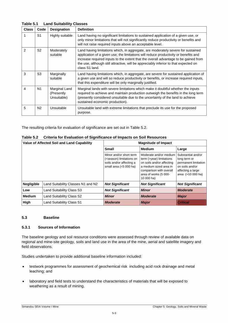
Table 5.1 Land Suitability Classes
Class Code Designation Definition
1 S1 Highly suitable Land having no significant limitations to sustained application of a given use, or only minor limitations that will not significantly reduce productivity or benefits and will not raise required inputs above an acceptable level.
2 S2 Moderately suitable
Land having limitations which, in aggregate, are moderately severe for sustained application of a given use; the limitations will reduce productivity or benefits and increase required inputs to the extent that the overall advantage to be gained from the use, although still attractive, will be appreciably inferior to that expected on class S1 land.
3 S3 Marginally suitable
Land having limitations which, in aggregate, are severe for sustained application of a given use and will so reduce productivity or benefits, or increase required inputs, that this expenditure will be only marginally justified.
4 N1 Marginal Land (Presently Unsuitable)
Marginal lands with severe limitations which make it doubtful whether the inputs required to achieve and maintain production outweigh the benefits in the long term (presently considered unsuitable due to the uncertainty of the land to achieve sustained economic production).
5 N2 Unsuitable Unsuitable land with extreme limitations that preclude its use for the proposed purpose.
The resulting criteria for evaluation of significance are set out in Table 5.2. Table 5.2 Criteria for Evaluation of Significance of Impacts on Soil Resources
Value of Affected Soil and Land Capability Magnitude of Impact
Small Medium Large
Minor and/or short term (<season) limitations on soils and/or affecting a small area (<5 000 ha)
Moderate and/or medium term (>year) limitations on soils and/or affecting a medium sized area in comparison with overall area of works (5 000-10 000 ha)
Substantial and/or long term or permanent limitation on soils and/or affecting a large area (>10 000 ha)
Negligible Land Suitability Classes N1 and N2 Not Significant Not Significant Not Significant
Low Land Suitability Class S3 Not Significant Minor Moderate
Medium Land Suitability Class S2 Minor Moderate Major
High Land Suitability Class S1 Moderate Major Critical
5.3 Baseline 5.3.1 Sources of Information The baseline geology and soil resource conditions were assessed through review of available data on regional and mine-site geology, soils and land use in the area of the mine, aerial and satellite imagery and field observations. Studies undertaken to provide additional baseline information included: testwork programmes for assessment of geochemical risk including acid rock drainage and metal
leaching; and
laboratory and field tests to understand the characteristics of materials that will be exposed to weathering as a result of mining.

Simandou SEIA Volume I Mine Chapter 5: Geology, Soils and Mineral Waste
5-4
In addition to the baseline studies completed to-date, the Project has implemented an on-going programme of site-specific surveys prior to ground disturbance. In the area around the mine, surveys are being undertaken ahead of construction and development to further define geotechnical and soil conditions. With regards to subsurface formations, drilling of the orebody will continue over the life of the mine, and that data will be used to update the understanding of the geochemistry of the deposits. For the mine process plant and other infrastructure, additional site investigations will be undertaken before the site layout is finalised. This will include collecting information on the quality of soils, to support subsequent soil and erosion management activities. 5.3.2 Geology and Mineral Waste The regional geology of the Project area is characterised by the crystalline Precambrian rocks of the southwestern part of the West African Craton. The Craton contains some of the oldest rocks on earth, and consists of an Archean basement dominated by migmatites and / or gneisses of varying granitic composition and small lenses of amphibolites. Figure 2.3 in Chapter 2: Project Description shows a simplified cross section of the Simandou Range and a simplified description of the geological baseline. A short summary of the geology of the site and the main minerals present is presented below.
Site Geology The Guinean Dorsal forms a geological domain dominated by granitic rocks and corresponds to a convexity of the crystalline Precambrian basement overlying the older Craton rocks. This geological domain also includes the N’Zérékoré Notch dominated by gneiss rocks. The Simandou Range is a younger metasedimentary rock sequence (Lower Proterozoic). It is composed of greenstone volcanic rocks with banded iron formations, which occur as linear belts and small relics throughout the Archean domain. A series of tectonic events of varying ages have affected the basement rocks. They have all contributed to the regional fabric of the rocks. More specifically, the regional Simandou fabric is characterised by the development of a large scale north to south sinistral shear system; and a second order northeast to southwest trending shear system. These shear zones are typically oriented northeast to southwest in Pic de Fon, and east to west in Ouéléba. Within the mine area the older and lowest member of the Simandou group rocks consists of a series of phyllite rock that overlies the Archean basement. Phyllite is a foliated metamorphic rock primarily composed of quartz, sericite mica, and chlorite minerals. The texture of the phyllite varies from very weathered and goethitised at the surface, to fresh and with pyritic occurrences at depth. An itabirite series is encountered above the basal phyllite. Itabirite is a rock that consists of laminated, metamorphosed, oxide-facies iron formation that contains large grains of quartz; and in which the iron is present as thin layers of haematite, magnetite, goethite, or martite minerals. The texture of the itabirite varies from friable to hard. Iron ore mineralisation is generally located on the top of the ridge, overlying the itabirite series, and has been encountered to a depth of more than 500 m. The primary iron ore minerals consist of oxide-hydroxide minerals with haematite the dominant mineral. Haematite is a black to silver-grey, brown to reddish brown or red mineral. It is hard rock with a rating of about 5.5 on Mohs scale. Goethite is another iron oxide-hydroxides mineral typically reddish brown in colour and is softer than haematite. In Pic de Fon and Ouéléba a carapace, or weathered crust, is encountered over the iron ore formations as a result of weathering and associated hydration of the mineralisation. Finally, numerous debris flows have deposited, typically in valleys perpendicular to the Simandou Range, iron rich poorly-sorted detrital materials, referred to as cangas. The cangas overlie the phyllite and basement rock with thicknesses ranging from a few metres up to 40 m.
As described in Chapter 2: Project Description, the extraction of the iron ore requires the mining of rock that is not considered as commercial-grade iron ore, termed waste rock or low-grade ore. Overall, some 1 750 million tonnes (mt) of waste and low grade ore will be extracted along with the ore. Of that material, approximately one third (about 600 mt) will be placed in mineral waste emplacement. There will be two large emplacements north of Ouéléba and south of Pic de Fon and a small emplacement near the Canga East Camp, with the balance being backfilled into the pits once space becomes available. Estimates of the types and quantities of materials from the two pits over the life of the mine are identified in Table 5.3. The estimates presented in Table 5.3 and discussed in this chapter are based on the mine plan at the time of writing and are subject to change as the plan is further developed. The materials are subdivided into four main groups (overburden, soft / weak phyllites / clays, friable and weathered rock, and hard compact rock).

Simandou SEIA Volume I Mine Chapter 5: Geology, Soils and Mineral Waste
5-5
The tonnages shown are the combined amounts for both external dumps and in-pit backfilling. The low-grade material will be stockpiled with but segregated from the waste material in the mineral waste emplacements. Table 5.3 Waste and Low Grade Ore Quantities
Material
Quantity (Mt)
Pic de Fon Ouéléba Total
Waste Low
Grade Ore
Total Pic de Fon
Waste Low
Grade Ore
Total Ouéléba
Overburden
Canga (CAN) 0.02 0.02 7.66 7.66 7.68
Weathered Carapace (CAP) 22.67 22.67 128.66 128.66 151.33
Laterite (LAT) 0.2 0.2 21.47 21.47 21.67
Bauxite (BAX) 2.32 2.32 2.32
Sub-total 22.89 22.89 160.11 160.11 183
Soft-Weak Phyllites/Clays
Soil Strength Phyllite (PHS) 0.89 0.89 19.25 19.25 20.14
Very Weak Phyllite (PHV) 15.65 15.65 229.4 229.4 245.05
Weak Phyllite (PHW) 33.76 33.76 137.08 137.08 170.84
Sub-total 50.3 50.3 385.73 385.73 436.03
Friable and Weathered Rock
Friable Haematite (HEF) 12.53 12.53 0.1 0.1 12.63
Friable Haematite-Goethite (HGF) 1.32 1.32 61.73 61.73 63.05
Friable Enriched Itabirite (IRF) 46.38 81.6 127.98 19.88 51.3 71.18 199.16
Friable Poor Itabirite (IPF) 9.72 172.8 182.52 2.59 47.4 49.99 232.51
Transitional Haematite-Goethite (TRN)
1.03 1.03 141.85 141.85 142.88
Weak Quartzite (QTW) 0 4.89 4.89 4.89
Weathered Haematite (WEA) 61.66 61.66 0 61.66
Weathered Goethite (WEG) 6.38 6.38 0 6.38
Sub-total 139.02 254.4 393.42 231.04 98.7 329.74 723.16
Hard Compact Rock
Compact Phyllite (PHC) 19.8 19.8 16.24 16.24 36.04
Compact Enriched Itabirite (IRC) 0 0 0
Compact Poor Itabirite (IPC) 143.47 44.3 187.77 87.94 87.1 175.04 362.81
Basement (BAS) 0 5.07 5.07 5.07
Compact Quartzite (QTC) 0 0.89 0.89 0.89
Compact Haematite (HEC) 0.08 0.08 0 0.08
Sub-total 163.35 44.3 207.65 110.14 87.1 197.24 404.89
Total 375.56 298.7 674.26 887.02 185.8 1 072.82 1 747.08
Note: These estimates are based on the current mine plan and will be subject to revision as the mine plan is developed.
5.3.3 Geochemical Characterisation 5.3.3.1 Overview A range of geochemical characterisation studies were undertaken to investigate the potential for acid generation, neutral drainage, salinity, and spontaneous combustion (organics) aspects of the mineral waste and low grade ore materials arising at the mine. The results indicated that acid rock drainage is the only issue for concern.

Simandou SEIA Volume I Mine Chapter 5: Geology, Soils and Mineral Waste
5-6
Acid rock drainage refers to the development of acidic conditions when mineral waste rock containing acid-generating sulphide minerals oxidise in an environment containing water. Acidic conditions lead to the release of metals from the rock matrices, a phenomenon known as metals leaching. The acidity and released metals may then be mobilised into adjacent soils, as well as surface and groundwater systems causing impacts on soil and water quality and ecological systems. Contamination of affected soils is discussed in this chapter and impacts on water quality resulting from ARD are discussed in Chapter 6: Water Environment. The assessment of impacts on soils from acid rock drainage requires an understanding of the acid generating and acid neutralisation potential of a given rock material and the quantity of potentially acid generating materials to be deposited in the external waste emplacements. The exposed walls of the open pits also present potential sources for contaminant mobilisation following weathering and oxidation of sulphide minerals that are exposed in the final faces. Several series of laboratory and field based geochemical investigations have been undertaken to characterise acid rock drainage and metal leaching potential for waste rock and wall rock assemblages. The geochemical data collected as part of the baseline studies is summarised in Annex 5A: Summary of Erosion and Geochemical Studies, and includes: drill core geochemical assay data; laboratory scale static and kinetic geochemical test programmes; and field-scale kinetic barrel tests. 5.3.3.2 Drill Core Analysis A very large geochemistry dataset has been generated, through a geological drilling and sampling programme conducted to delineate the geological units in the Simandou range. Drill cores collected by the exploration drilling programme were assayed for sulphur content. A conservative assumption has been used with all sulphur assumed to be present as pyrite and therefore available to contribute to acid rock drainage. Work to-date has identified the presence of elevated levels of pyrite and therefore potential for acid rock drainage, predominantly within the phyllite lithology, all of which is waste rock. The four phyllite types are grouped into two classes primarily on their geotechnical characteristics.
Weak Phyllite (PHW), Very Weak Phyllite (PHV) and Soil Strength Phyllite (PHS): these phyllite
materials are typically highly leached, leading to geotechnically weak, often clayey or soil-like material; these form the soft and weak phyllites class in Table 5.3 and total some 436 mt (50 mt at Pic de Fon and 356 mt at Ouéléba).
Compact Phyllite (PHC): this material has undergone less leaching, making it a stronger, generally hard
coherent rock that often contains pyrite; these form part of the hard compact rock class in Table 5.3 and total some 36 mt (20 mt at Pic de Fon and 16 mt at Ouéléba).
5.3.3.3 Laboratory Testing Geochemical testing of representative samples of all major ore and waste rock units was carried out during the period 2008 to 2011. Static tests were completed for a total of 172 core samples, 18 of which were compact phyllite (PHC). Kinetic testing was also carried out using humidity cells to determine the characteristics of samples over time. Tests were conducted on twelve composite samples, five for Ouéléba and seven for Pic de Fon. Each composite consisted of material aggregated from at least five individual material types. Humidity cell tests were run for a period of 20 weeks, with weekly cycles of dry and humid conditions followed by flushing and sampling. These results confirm the drill core assay results that all major rock units are effectively inert with the exception of PHC material. For PHC the average Net Acid Generating (1) (NAG) pH is 2.3 with average and
(1) NAG is the net acid generation potential from a sample. A NAG pH less than 4.5 indicates the sample is acid producing.
Simandou SEIA Volume I Mine Chapter 5: Geology, Soils and Mineral Waste
5-7
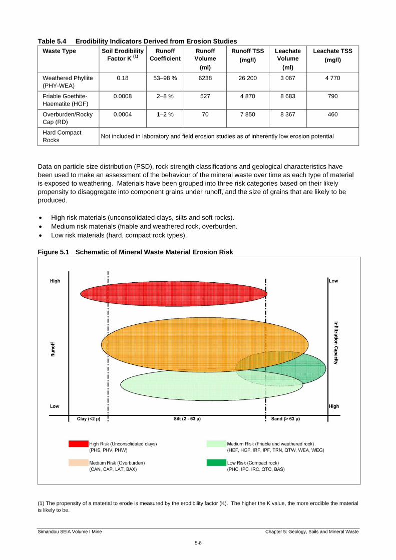
maximum Net Neutralising Potential (1) (NNP) values of -41.8 and 141 kg/t CaCO3 respectively. PHC from Ouéléba was generally found to have a higher acid generating and metal leaching potential than material from Pic de Fon. 5.3.3.4 Field Tests To supplement the geochemical testing and modelling work a barrel test programme was designed to assess the chemical evolution of contact water produced by infiltration into mixed assemblages of waste rock. Six test barrels were constructed. Each barrel was filled with varying proportions of waste rock, including varying proportions of the phyllite material to represent a range of mixes of mineral waste types. The test barrels have been exposed to the local climate that will be experienced by the full-scale waste rock facilities since August 2009 and are tested monthly when there is sufficient rainfall for sampling. The test barrels have had sufficient time for natural bacteriological weathering processes to occur, processes that may be under estimated in more rapid laboratory tests. Therefore, the concentrations of solutes released during the barrel tests provide good approximations of the geochemical process and leaching of waste rock materials under field conditions over an extended period. The results from the test barrels have been used to verify the predictions from the other test work and the modelling. In summary, compact phyllite (PHC) is the primary concern with respect to acid rock drainage generation. In total about 36 mt of PHC is precietd to be generated (about 3% of the total quantity of mine waste and 7% of the material to be disposed of in the external waste emplacements). Of this some 20 mt will arise at Pic de Fon and 16 mt at Ouéléba, mainly during the first 10 years of operation. Whilst the greater quantity of PHC will be produced from the Pic de Fon pit, higher risk material will arise from Ouéléba. 5.3.4 Erosion Studies Laboratory and field studies have been conducted to determine the erodibility characteristics of a range of soils, overburden and waste rock that comprise the majority of the material types that will be exposed during the course of mining and will form the mineral waste emplacements. These involved small laboratory test trays and five large scale erosion field plots. The details of the studies and their results are presented in Annex 5A: Summary of Erosion and Geochemical Studies and the key findings are summarised here. Three types of particle size distribution (PSD) analyses were conducted on each of the trays and field plots: dry aggregate distribution: the PSD of the dry material as placed in the trays; erosion PSD: the grain size of material transported in runoff; and leachate PSD: the grain size distribution of material contained in the leachate. The testing also produced results for other indicators of erodibility, including total sediment loss, runoff and leachate volumes. These data have been used to derive comparative values of runoff coefficient and infiltration capacity for each material type tested. Table 5.4 presents the key results of the laboratory and field tests. Figure 5.1 shows the range of results for each of the main waste types.
(1) NNP is the net neutralising potential of a sample measured as the equivalent amount of calcium carbonate available in that sample. This test is used to estimate the capacity of the sample to neutralise acidity and / or release excess alkalinity that would reduce the impact of acidity from other materials.
Simandou SEIA Volume I Mine Chapter 5: Geology, Soils and Mineral Waste
5-8
Table 5.4 Erodibility Indicators Derived from Erosion Studies
Waste Type Soil Erodibility Factor K (1)
Runoff Coefficient
Runoff Volume
(ml)
Runoff TSS
(mg/l)
Leachate Volume
(ml)
Leachate TSS
(mg/l)
Weathered Phyllite (PHY-WEA)
0.18 53–98 % 6238 26 200 3 067 4 770
Friable Goethite- Haematite (HGF)
0.0008 2–8 % 527 4 870 8 683 790
Overburden/Rocky Cap (RD)
0.0004 1–2 % 70 7 850 8 367 460
Hard Compact Rocks
Not included in laboratory and field erosion studies as of inherently low erosion potential
Data on particle size distribution (PSD), rock strength classifications and geological characteristics have been used to make an assessment of the behaviour of the mineral waste over time as each type of material is exposed to weathering. Materials have been grouped into three risk categories based on their likely propensity to disaggregate into component grains under runoff, and the size of grains that are likely to be produced. High risk materials (unconsolidated clays, silts and soft rocks). Medium risk materials (friable and weathered rock, overburden. Low risk materials (hard, compact rock types). Figure 5.1 Schematic of Mineral Waste Material Erosion Risk
(1) The propensity of a material to erode is measured by the erodibility factor (K). The higher the K value, the more erodible the material is likely to be.
Simandou SEIA Volume I Mine Chapter 5: Geology, Soils and Mineral Waste
5-9
5.3.4.1 High Risk Materials This group of waste materials (unconsolidated clays, silts and soft rocks) comprises soft to weak phyllites (PHS, PHV and PHW). These are materials of little cohesive strength, and when weathered and disaggregated break down to very fine grained materials that may give rise to high suspended sediment loads in runoff. These materials are the largest single waste type on Ouéléba, with approximately 386 million tonnes (mt) scheduled for deposit at the Ouéléba waste emplacement. The amount of phyllite to be placed in the Pic de Fon emplacement is less at about 50 mt. 5.3.4.2 Medium Risk Materials Two subcategories of mineral waste have been identified that are likely to present a medium risk of sediment generation. These are friable and weathered rock, and overburden. Friable and Weathered Rock This category of materials comprises a major component of wastes in both Pic de Fon (139 mt) and Ouéléba (231 mt) waste emplacements. Substantial quantities of friable materials that are near commercial grade ore will also be separately stockpiled within each emplacement (254 mt in Pic de Fon and 99 mt in Ouéléba). Overburden Overburden comprises a relatively minor component of mineral waste on Pic de Fon (about 23 mt), but is a major waste on Ouéléba (about 160 mt). Weathered Carapace is the dominant type, with smaller quantities of Canga, Laterite and Bauxite. The various overburden materials are the least homogenous and comprise a wide range of material properties and grain sizes. The results indicated the lowest erodibility factor (K) for all of the materials tested, suggesting that the carapace is more resistant to erosion than other waste types. 5.3.4.3 Low Risk Materials Hard compact rock materials that do not disaggregate into component grains are a large component of mineral waste on both Pic de Fon (165 mt) and Ouéléba (110 mt). In summary, the material to be disposed of in the Ouéléba waste emplacement contains a higher proportion of material with a high and medium erodibility (unconsolidated materials, friable risk and overburden) than the material from Pic de Fon which has a higher proportion of hard and compact rock types of low erodibility. 5.3.5 Soils The near surface geology, climate and topography are the main drivers of the type of soils that are found in the mine study area. Baseline conditions were assessed through review of available data on geology and soils in the study area, aerial and satellite imagery and field observations. Soil quality was surveyed during 2008 based on 24 sample locations around the Simandou ridge. Land capability has been inferred from the baseline geology, soils and topography. The topography is mountainous and undulating. The mine concession area occupies the southern part of the Simandou range over a distance of about 25 km and the proposed mining area runs over about 15 km around the Pic de Fon and the Ouéléba ridge. The wider area includes steeply sloped hills, separated by deep depressions (ravines) gradually changing into foothills and elevated plains. The steeper slopes have been eroded through the action of rainfall on the surface rock and soils and the subsequent movement of water across the surface and into streams. Where the slopes lessen and the velocity of the water decreases heavier soil particles have been deposited, often forming areas with deeper soil profiles that tend to be of moderate agricultural value. The foothill valleys contain small ephemeral streams with alluvial areas if high agricultural value known as bas fonds.
Simandou SEIA Volume I Mine Chapter 5: Geology, Soils and Mineral Waste
5-10
Figure 5.2 overleaf shows the major soil types identified in the area around the mine. The approximate area cover of each type of soil within a reference area up to 3 km from the perimeter of the mine site is presented in Table 5.5. Table 5.5 Soil Types within 3 km of the Mine
Soil Type Value Area (ha) % of total
Lithic soils and duricrust Negligible (N1 and N2) 5 155 12%
Ferralitic soils (loose and hardened latosols) Low (S3) 21 175 51%
Soils rejuvenated by erosion Medium (S2) 14 330 35%
Hydromorphic soils Medium to High (S2 and S1) 605 1%
Total 41 265 100%
As shown on Figure 5.2, ferralitic soils dominate the area, covering the plateaus surrounding the Simandou ridge. They include loose and hardened latosol soils. These ferralitic soils are very weathered, typical of humid tropical climates. They are thick and show generally yellowish or reddish colours. They are rated as having low agricultural value and as falling into Land Suitability Class S3. The soil profile encountered along the Simandou ridge itself comprises lithic soils developed over the carapace and bedrock. These soils are usually thin and display a lack of horizon resulting from a steep slope environment, or from the occurrence of parent materials without any permanent weatherable minerals. Some areas of duricrust may be only a few millimetres to a few centimetres thick. Lithic soils offer no significant value for agricultural uses and are considered to fall into Land Suitability Classes N1 and N2. In some areas, bedrock erosion has exposed young materials that have accumulated on lower slopes. These soils, which have been rejuvenated by erosion (ie a process whereby erosive processes transport nutrients to an otherwise impoverished soil), contain laterite soils and rock particles in various proportions. Some of them also include clay material. They represent a moderate value for agricultural uses and fall into Land Suitability Class S2. Finally, small areas of alluvial soils (fluvisols and gleysols) are locally encountered in the valleys of small intermittent streams and along several perennial streams. Hydromorphic gleysols have generally developed under conditions of poor drainage. These soils typically exhibit medium to high value for agricultural uses, and can sustain various types of crops, such as cereals, vegetables and fruits. These soils are primarily encountered near the streams and bas fonds and are potentially subject to occasional flooding. They are considered to fall into Land Suitability Classes S2 and S1. 5.3.6 Soil Contamination Within the footprint of the proposed mine site, the area is essentially rural, with no settlements and it is not expected that there will be any occurrence of existing soil contamination. This is confirmed by analyses of soil chemistry which show no evidence of any existing sources of pollution with all parameters (sulphur, cyanides, metals, hydrocarbons) being at natural background levels (1). 5.4 Assessment of Impacts 5.4.1 Overview The impacts of the mine project on soil resources are considered under the following headings: contamination from acid rock drainage; loss of and physical damage to soil resources; degradation of soils in borrow pits and spoil disposal areas; and (1) SNC Lavalin (2010). Social and Environmental Baseline Study: Simandou Project Mine Component.

Simandou SEIA Volume I Mine Chapter 5: Geology, Soils and Mineral Waste
5-11
contamination from other sources, including spills. Impacts to water from acid rock drainage and sedimentation are addressed in Chapter 6: Water Environment. In each case the impacts related to the three phases of development: construction, operation and closure are presented. The construction phase includes the disturbance of soils from construction of the mine plant, workshops and offices, stockyard, accommodation camp, power plant and roads including the primary haul roads from the workshops to the mine pits and the mine access road. It will also include the establishment of any borrow pits for the supply of construction material and the disposal of any surplus spoil which is unsuitable for use in the construction process. In operation of the mine the primary disturbance will be the progressive clearance of vegetation and soils ahead of mining, and the development and operation of the mineral waste emplacements. This includes clearing vegetation and pre-stripping soil within the pit footprint, in-pit haul road construction, mineral waste emplacement preparation, and general operation of the mine equipment. Closure of the mine will include decommissioning of the plant and equipment and will generally have impacts similar to those occurring during construction. 5.4.2 Contamination from Acid Rock Drainage 5.4.2.1 Construction Impacts Construction of the mine works is very unlikely to expose potentially acid forming material as this material is located well below the surface and will not be disturbed until mining operations have reached a considerable depth. The potential for exposure of potentially acid forming material is therefore considered to be negligible and the impact during construction is not significant. 5.4.2.2 Operational Impacts The operation of the mine is highly likely to expose potentially acid forming mineral waste as the mining pits are opened up to extract the ore. The potentially acid forming mineral waste comprises only a small part of the total mineral waste (about 36 mt or 7% of the waste to be deposited in the external waste emplacements) but there is the potential for metal contaminated and acidic leachate to run off causing an adverse impact on quality of adjacent soils. This could prevent the establishment of vegetation and cause existing vegetation to die as acidity levels and concentration of some dissolved metals increase. The studies summarised in Annex 5A: Summary of Erosion and Geochemical Studies indicate that the potentially acid forming wastes are likely to react quickly and that there is little buffering capacity in other waste to reduce the impact. In the absence of mitigation, the magnitude of impact will be large. The neighbouring soils are of low or medium value, and the significance of impacts, will therefore be moderate to major.

Domanidou
Foma
TourélaFandou
ManankoroKankoro
Banko Koimoridou
CangaEast
Camp
Mandou
Orono
BanankoroLamandou MafindouMoribadou
GoékoroThia
Mamouroudou
KorèlaWataférédou II
KabakoroNiadou
Wataférédou I BobaroTraoréla Siatouro
Morisangarédou
Boulaydou
PiyaroNionsomoridou KouwandalaKamandou
Bangalydou
Gbagbadou
Soumailadou
Sibiridou
KamiandouYendédouMoribiendou
Kissiboula
N.1
8°50'0"W
8°50'0"W
9°0'0"W
9°0'0"W
8°40'0
"N
8°40'0
"N
8°30'0
"N
8°30'0
"N
510000
510000
520000
520000
530000
530000
9400
00
9400
00
9500
00
9500
00
9600
00
9600
00
9700
00
9700
00
Client: Taille: Titre:
Date: 25/06/2012
Dessiné par: WB
Vérifié par: PS
Approuvé par: KR
Projet: 0131299
Echelle: Comme barre d'échelle
Légende:Figure 5.2Sols dans la zone minière /Soils in the Mine Area
Zone d'étude / Study AreaUsine et infrastructures minières /Mine Plant & InfrastructureContour de mine / Mine OutlineTerril de stériles / Waste EmplacementProjet de route de la mine /Proposed Mine RoadLocalisation de la base de vie / Camp LocationZone de stockage d'explosifs /Explosives Storage AreaZone d'exclusion autour de lazone de stockage d'explosifs /Explosives Area Clearance Zone
Dépôt de carburant / Fuel Farm
Centrale électrique / Power StationTracé indicatif de la voie ferrée /Indicative Rail AlignmentAgglomération / SettlementRoute principale / Primary RoadRoute secondaire / Secondary RoadRoute tertiaire / Tertiary RouteCours d'eau / Watercourse
Projection: WGS 1984 UTM Zone 29N
File:
0131
299S
iman
douG
IS_IG
_CK\M
aps\E
RM\S
oil\M
ay20
12_re
vision
s\mi_s
oil_c
lass.m
xd
A4
0 4
kilomètres
G u i n e aG u i n e a
M a l iM a l i
S i e r r aS i e r r aL e o n eL e o n e
S e n e g a lS e n e g a l
C o t eC o t ed ' I v o i r ed ' I v o i r eL i b e r i aL i b e r i a
Type de sol / Soil TypeCuirasse ou croûte / Duricrust or CrustLatosol meuble / Loose LatosolLatosol durci / Hardened LatosolSol Hydromorphique / Hydromorphic SoilLithosols sur différentes roches / Lithosol on Various RocksSol rajeuni par l'érosion /Soil rejuvenated by erosion
Simandou SEIA Volume I Mine Chapter 5: Geology, Soils and Mineral Waste
5-13
5.4.2.3 Closure Impacts The potential for metal and acid leachate generation from waste emplacements will decline over time but a risk of continuing acid rock drainage will persist in the long term after closure of the mine. In the absence of mitigation the significance of impact during closure will continue to be moderate.
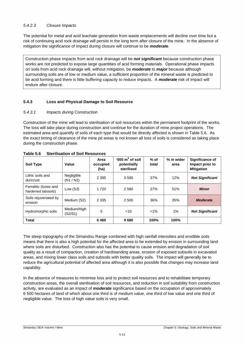
5.4.3 Loss and Physical Damage to Soil Resource 5.4.3.1 Impacts during Construction Construction of the mine will lead to sterilisation of soil resources within the permanent footprint of the works. The loss will take place during construction and continue for the duration of mine project operations. The estimated area and quantify of soils of each type that would be directly affected is shown in Table 5.6. As the exact timing of clearance of the mine pit areas is not known all loss of soils is considered as taking place during the construction phase. Table 5.6 Sterilisation of Soil Resources
Soil Type Value Area
occupied (ha)
‘000 m3 of soil potentially sterilised
% of total
% in wider area
Significance of Impact prior to Mitigation
Lithic soils and duricrust
Negligible (N1 / N2)
2 395 3 590 37% 12% Not Significant
Ferralitic (loose and hardened latosols)
Low (S3) 1 720 2 580 27% 51% Minor
Soils rejuvenated by erosion
Medium (S2) 2 335 2 500 36% 35% Moderate
Hydromorphic soils Medium/High (S2/S1)
5 <10 <1% 1% Not Significant
Total 6 460 9 680 100% 100%
The steep topography of the Simandou Range combined with high rainfall intensities and erodible soils means that there is also a high potential for the affected area to be extended by erosion in surrounding land where soils are disturbed. Construction also has the potential to cause erosion and degradation of soil quality as a result of compaction, creation of hardstanding areas, erosion of exposed subsoils in excavated areas, and mixing lower class soils and subsoils with better quality soils. The impact will generally be to reduce the agricultural potential of affected area although it is also possible that changes may increase land capability. In the absence of measures to minimise loss and to protect soil resources and to rehabilitate temporary construction areas, the overall sterilisation of soil resources, and reduction in soil suitability from construction activity, are evaluated as an impact of moderate significance based on the occupation of approximately 6 500 hectares of land of which about one third is of medium value, one third of low value and one third of negligible value. The loss of high value soils is very small.
Construction phase impacts from acid rock drainage will be not significant because construction phase works are not predicted to expose large quantities of acid forming materials. Operational phase impacts on soils from acid rock drainage will, without mitigation, be moderate to major because although surrounding soils are of low or medium value, a sufficient proportion of the mineral waste is predicted to be acid forming and there is little buffering capacity to reduce impacts. A moderate risk of impact will endure after closure.

Simandou SEIA Volume I Mine Chapter 5: Geology, Soils and Mineral Waste
5-14
5.4.3.2 Operational Impacts The mining operation will progressively create a new landform comprising mine pits, mineral waste emplacements, earthworks for roads, conveyors and other structures, and other cleared areas, where risks of erosion from slopes and exposed soils will arise. These landforms will either consist of the natural material remaining in the pit walls following removal of the ore, or be constructed from fill material or mineral waste. Although the soil resource will generally be of negligible or low value, much of it will be moderately to highly erodible. In the absence of mitigation exposed soils can be expected to be slow to stabilise and revegetate. In addition, the sediment released through erosion would likely result in smothering of adjacent vegetated areas leading to plant death. Erosion would likely continue for an extended period and the magnitude of impact on soil resources is predicted to be large. Without controls the resulting loss of soil resources of negligible or low value will result in a minor to moderate impact. Note that the progressive loss of soils in the mine pit areas during operation is considered together with the clearance of the rest of the site under the construction phase. The impacts generated by soil erosion on water resources (essentially associated with increased turbidity in streams) are addressed in Chapter 6: Water Environment. 5.4.3.3 Closure Impacts The decommissioning of the mine will require short term disturbance of soils as buildings are demolished, and haul roads, conveyors and other supporting infrastructure are removed. These areas will be rehabilitated but will take some time for soil quality to be restored. The area rehabilitated after decommissioning and removal of mine facilities will be in the order of 2 000 ha. In the absence of mitigation measures the magnitude of impact on soil resources of mostly low to medium value during decommissioning will be small and the resulting impact will be of minor significance. Taking into account the long term benefit from rehabilitation the overall impact is considered to be not significant.
In summary the loss of soil resources during construction and operation will, without mitigation, be of minor or moderate significance. During and after closure of the mine the net effect of soil disturbance and erosion impacts and soil rehabilitation will be not significant.
5.4.4 Borrow Pits and Spoil Disposal Construction of the mine will involve substantial earthworks to create platforms for haul roads, waste emplacements and the mine plant and stockyard areas. The detailed design of the mine site will be developed with the aim of minimising the need for import of material and for export of surplus material. To avoid the need to move large quantities of material over long distances and to ensure there is adequate material of a suitable quality in the right locations, there may therefore be the need to establish borrow pits within or near the mine site. In this context a borrow pit is defined as a source of earth or similar soft fill material that can be extracted by simple excavation, without the need for blasting or significant processing. Locations where hard materials such as rock are extracted are identified as quarries and are subject to a separate Class SEIA which was approved in May 2012 (1). In addition to the need to source fill material it is likely that there will be some need to dispose of surplus material created from earthworks. The Project will seek to use as much material as possible within the construction works, for example in creation of haul roads, embankments and berms, but some material is likely to be generated in locations where it cannot practicably be used and some material is likely to be unsuitable for use because of its qualities. This surplus and unsuitable material (spoil) will need to disposed of in appropriate locations.
(1) Rio Tinto (2012). Simandou Project Class Social and Environmental Impact Assessment (SEIA) Quarry Programme.
Simandou SEIA Volume I Mine Chapter 5: Geology, Soils and Mineral Waste
5-15
The establishment of borrow pits and disposal of spoil will lead to sterilisation of land and soil resources in the affected areas during construction. No relevant activities are envisaged during operation or closure. At this stage in the design of the mine it is not possible to estimate the amount of material involved or the areas or locations of land that will be affected, but it is likely that there will be significant impacts on soils and other land-based environmental resources from this source.
5.4.5 Contamination from Discharges and Spills 5.4.5.1 Construction Impacts There is potential for pollution of soils to arise from any intentional disposal of effluents or other wastes to land and from accidental spills of hydrocarbons (primarily fuel) and other hazardous substances used in construction of the mine (solvents, paint etc). There will be no planned discharge of untreated effluents or uncontrolled disposal of waste to the land and impacts from these sources will therefore be not significant. Spills will inevitably occur and may vary from very small spills (a few litres or less) causing only very localised and short term pollution, to larger events, such as for example loss of containment of fuel storage tanks or a tanker truck accident that could release up to 30 000 litres of fuel. Based on the size of potential spills and their relative likelihood (probable for very small spills; unlikely for larger spills) the magnitude is predicted to be small and the resulting impact on soils, even in areas of higher value, would be of minor significance (1). 5.4.5.2 Operational Impacts The potential for pollution of soils from spills of hazardous substances will continue during operation of the mine and the magnitude, likelihood of impacts and the value of affected resources will be the same so that impacts will continue to be of minor significance for soils. 5.4.5.3 Closure Impacts After closure risks of spills of hazardous materials will continue for a short period whilst decommissioning activities are under way with the same risk as during construction.
5.5 Mitigation Measures and Residual Impacts 5.5.1 Overview The measures proposed to mitigate the impacts identified in Section 5.4 and the assessment of residual impacts after mitigation are discussed below. The mitigation measure and residual impacts are reported as follows: contamination from acid rock drainage; loss of and physical damage to soil resources; degradation of soils in borrow pits and spoil disposal areas; and contamination from other sources including spills. A key overarching element of planning for mitigation of all these impacts will be the development and implementation of a Mineral Waste Management Plan (MWMP) and a Land Use Management Plan for the mine. This will include:
(1) The implications of such events for the Aquatic Environment in the event of a spill happening near water are discussed in Chapter 6:
Water Environment.
In summary impacts on soils from spillages during construction, operation and closure will, without mitigation, be minor.
Simandou SEIA Volume I Mine Chapter 5: Geology, Soils and Mineral Waste
5-16
physical and geochemical characterisation; management of acid rock drainage material; design and operation of mineral waste emplacements; and rehabilitation and closure. These plans will be developed during completion of the detailed design and will be regularly updated during construction and operation as new information becomes available on the nature, quantities and risks associated with waste materials and the future land use plans for the site. They will include the specific commitments presented in the following paragraphs. 5.5.2 Acid Rock Drainage 5.5.2.1 ARD in the Mineral Waste Management Plan The MWMP will include a range of controls integrated with the design and operational plan for the mine to ensure the identification and management of all potentially acid forming mineral waste. Further studies will be undertaken to determine the risk of acid rock drainage and identify necessary control measures. Measures may include: delineation and characterisation of potentially acid-generating material by:
routine sampling of the waste material to provide on-going information regarding the acid generation
potential; sulphur analysis of production drill cuttings; and delineation of working mine faces with visual markers to facilitate selective handling.
selective handling and segregation in waste emplacements;
covering with inert or buffering materials to provide a physical barrier; shaping waste emplacement surfaces to reduce ponding and infiltration of rainfall; installation of underdrains to collect and separate any leachate from the emplacement; provisions for leachate treatment if required to comply with the discharge criteria for receiving waters
(see Chapter 6: Water Environment); and monitoring of leachate from waste emplacements. Work on the mitigation strategy for acid rock drainage has been conservative to date in that all compact phyllite materials have been assumed to be acid-forming. In practice geological models suggest that some 30% of the compact phyllite may be non-acid generating and further studies will seek to refine these estimates such that a more accurate measure of potentially acid-generating material is known prior to mining of high risk material. 5.5.2.2 Assessment of Residual Impacts associated with ARD With these measures in place the impact of acid rock drainage on soil resources will remain a significant issue to manage on a routine basis in the mine plan. However, the MWMP will provide a framework to ensure on-going identification and management of the issue. With implementation of the controls described above the risk of adverse impacts on soils from ARD will be reduced to moderate during operations. Once the mine reaches the closure stage, the revegetation of the external waste emplacements will have been in place for up to 30 years by the time mining ceases, so the effectiveness and longevity of acid mine drainage controls will have been monitored for an extended period. Acid rock drainage is not therefore expected to cause significant impact in the long term, unless the control system fails. In this event soils and

Simandou SEIA Volume I Mine Chapter 5: Geology, Soils and Mineral Waste
5-17
vegetation over most of the waste emplacements and downstream could be damaged leading to a continuing minor risk of impact on soils after closure. Impacts of ARD on water resources are assessed in Chapter 6: Water Environment. 5.5.3 Erosion from Waste Emplacements and from Soils 5.5.3.1 Managing Erosion from Mineral Waste Emplacements The mineral waste emplacements are currently predicted to occupy about 550 ha across three locations at Ouéléba, Pic de Fon and Canga East. As described in Sections 5.3.4 and 5.4.3, there is a significant risk of erosion from the emplacements with loss on soil resources and impacts on downstream soils. To mitigate against these impacts the design and operation of the mineral waste emplacements (including any long term, low grade stockpiles) will include: placement of less erodible materials on the outer surfaces to minimise erosion and sediment generation;
constructing the emplacements such that the height gradient and slope length of final faces are
designed to reduce erosion and facilitate rehabilitation objectives;
shaping the mineral waste emplacement surfaces to direct runoff away from the face and towards stable surfaces or engineered structures with erosion controls in place;
constructing diversion and interception drains around the waste emplacements to minimise water flowing onto the emplacements; and
progressively revegetating non-working faces as soon as practicable and using temporary erosion control measures where faces are exposed for extended periods.
With these measures, erosion from waste emplacements should be reduced to a small magnitude impact on a low to medium value resource with a residual impact of minor significance for all phases of the Project. Impacts of erosion from waste emplacements on water resources are assessed in Chapter 6: Water Environment. 5.5.3.2 Minimising Loss of Soil Resources, Topsoil Protection and Erosion Control In order to minimise the sterilisation of soil resources during construction and operation of the mine the area of land to be occupied for the mine project will be kept to the minimum necessary for the works. Within this area productive soils (topsoils and subsoils) will only be removed where necessary and affected land will be returned to beneficial use as soon as possible after completion of construction (for temporary land) or after closure of the mine (for operational areas). Where valuable soils are stripped for the works this soil will be carefully removed and made available for re-use as outlined below. A Land Use Management Plan will be developed by the Project before the start of construction, setting out land use zones and management objectives for all land used by the Project, how land and soils disturbed by the Project will be rehabilitated after construction, operation and closure and detailing how progressive rehabilitation of the mined area will be carried out. The Land Use Management Plan will include the following measures to minimise impacts on soil resources: topsoil stripping, stockpiling and management will be planned prior to ground disturbance works
commencing;
topsoil (and subsoil where deemed necessary) will be salvaged for re-use;

Simandou SEIA Volume I Mine Chapter 5: Geology, Soils and Mineral Waste
5-18
soil resources will be re-used as soon as possible after stripping by re-spreading on adjacent areas or stored in segregated stockpiles for later use in site rehabilitation;
soil resource inventories will be maintained detailing quantities required (for rehabilitation), salvaged and
storage locations, age etc;
design and management of stockpiles to minimise loss of soil and degradation of soil quality by erosion, poor storage and compaction;
long term soil stockpiles will be height constrained and revegetated if required to promote seed viability
and reduce erosion; and
protection of soils outside work areas by prohibiting the movement of vehicles and equipment outside designated areas.
The Land Use Management Plan will include the following measures for erosion control: avoiding unnecessary disturbance of stable surfaces;
avoiding unnecessary clearance of vegetation;
locating temporary construction areas away from land susceptible to erosion;
avoiding works within 50 m of a river or stream unless necessary for crossing works;
scheduling works with high erosion potential to avoid periods of intensive rainfall where possible;
diversion of surface run-off from exposed areas;
use storm water and sediment retention ponds to reduce erosion and sediment loads in discharges;
stabilising exposed surfaces using controls such as re-vegetation;
armour drainage lines and off-takes using vegetation and stone pitching (rip rap);
implementing maintenance programmes to ensure sediment control structures are fully functioning; and
rehabilitating disturbed areas as soon as possible after completion of works. The Project will also carry out acid sulphate soils (ASS) surveys and develop and implement an ASS Management Plan if required. These measures will reduce the sterilisation, loss of and damage to soil resources to a small magnitude impact on a low to medium value resource and the residual impact will be of minor significance in all phases of the mine project. 5.5.4 Borrow Pit and Spoil Management The Project will adopt a range of measures to minimise the adverse impacts from sourcing of material for construction and disposal of surplus spoil. Borrow pits will be developed and operated in accordance with the following requirements: used for short term extraction of soft materials (soil, sand, gravel etc) required solely for the purposes of
the Project;

Simandou SEIA Volume I Mine Chapter 5: Geology, Soils and Mineral Waste
5-19
material will be extracted using mobile excavators. There will be no requirements for blasting, crushing or similar processing. (Sources of hard materials and materials requiring blasting or processing will be treated as quarries and will be managed in accordance with the Class SEIA for the Simandou Quarries Programme);
will avoid any specific locations of importance for biodiversity or cultural heritage;
will be located at least 300 m from the nearest residential property unless a shorter distance is agreed
during community consultation;
will avoid loss of productive agricultural land (cultivated and fallow land) as far as possible;
will be located at least 50 m for the nearest watercourse;
not exceed 6 m in depth or penetrate the water table whichever is the shallower;
will be equipped where necessary with sediment traps to reduce discharge of sediment into surface waters;
sites with evidence of weed infestations will be avoided where possible. If sites contain weeds then
appropriate weed treatment, hygiene and control will be implemented prior to disturbance;
as soon as possible after completion of works, borrow pits will be rehabilitated;
final landforms will be free draining, not form dams or ponds, and take into account public safety, wildlife safety, pre-disturbance habitats and future beneficial use;
will be subject to a photographic record of their development; and
will be developed in accordance with the provisions of the PARC Framework.
Surplus and / or unsuitable material generated from earthworks and tunnelling will be managed in the following manner: re-used for general fill, berms, access routes, noise barriers, profiling of used borrow pits, visual and
noise shielding, community purposes and other useful means wherever possible;
In the event that surplus material still exists it will be disposed of within the construction footprint if possible;
a spoil disposal plan will be developed for all sites prior to the start of use and will cover aspects of weed
management, drainage and erosion control and rehabilitation methods;
rehabilitation will take place as soon as possible after completion of works, and take into account public safety, wildlife safety, pre-disturbance habitats and future beneficial use; and
if additional land outside the construction footprint is required to dispose of excess spoil the above
requirements also apply and development occurs in accordance to any provisions under the PARC Framework and in consultation with government and local communities.
Whilst it is not possible at this stage to predict the impacts of borrow and spoil disposal prior to or post- mitigation, careful attention to the cut and fill balance in design of the mine, appropriate siting of facilities, and adoption of best practices in their design and operation, will keep the impacts as low as reasonably practicable.

Simandou SEIA Volume I Mine Chapter 5: Geology, Soils and Mineral Waste
5-20
5.5.5 Contamination from Accidental Spills As noted in Section 5.4.4 there will be no intentional discharges of hazardous substances to land from the Project other than the controlled disposal of waste in specifically designed facilities. These will meet strict standards for design and operation and will be subject to grant of all required permits from the Republic of Guinea. With these measures no significant impacts will occur from intentional releases. An Emergency Prevention, Preparedness and Response Plan will be prepared prior to commencement of construction and updated for operation and closure, to detail how the Project will minimise the likelihood and consequences of accidental spills causing pollution of soils during all phases of the Project. This will include requirements for: emergency scenarios; spill detection in storage facilities and pipelines; provision and location of spill response and clean up equipment; spill containment and clean-up procedures; training of staff; and testing and emergency drills. All hydrocarbon and other chemical storage facilities will be designed to minimise the risk of escape of any accidental spills including: secondary containment for storage of hazardous materials must provide minimum of 110% containment
of the largest tank or 25% of the total volume;
location of all equipment, containers and distribution lines (including pipes, valves and taps), containing hazardous materials above ground and provision of appropriate containment to minimise the risk of uncontrolled or undetected releases of hazardous materials; any below ground installations require appropriate risk assessment and Project approval;
spill detection; and
containment of any transfer points so that any spill during refilling is directed to the containment
structure. Further measures will be taken to reduce risks to soils from the storage and handling of hazardous substances and these are similar to those proposed to protect water quality, as presented in Chapter 6: Water Environment. All spills that do occur will be cleaned up and sites remediated to enable their continued use. Hazardous wastes arising from spill clean-up will be treated and disposed of at suitable waste management facilities in accordance with the Project Non-Mineral Waste Management Plan (see Chapter 11: Resources and Non-Mineral Waste Management). With these measures in place the residual impacts from accidental spills in all phases of the mine project should be not significant. 5.6 Summary of Findings The assessment identified a number of impacts related to geology, mineral waste and soils during construction, operation and closure of the mine. The results are summarised in Table 5.7 giving an evaluation of the significance of impacts prior to mitigation, identifying key mitigation measures, and evaluating the residual impacts after mitigation. In summary the residual impacts after mitigation will be as follows. Moderate impacts remain after mitigation of acid rock drainage during the operational phase. This is
the result of the large volume of mineral waste being moved and the large areas of the waste emplacements. Other impacts will be minor or not significant.
Simandou SEIA Volume I Mine Chapter 5: Geology, Soils and Mineral Waste
5-21
The impacts from loss and degradation of soil resources will be minor to moderate during construction and operation and not significant after closure in all phases of the mine project.
Borrow pit and spoil management activities will be designed and implemented with the objectives of
minimising the quantities of material requiring extraction and disposal and ensuring appropriate siting, design and operation of any necessary facilities, will ensure the impacts of sourcing and disposal of material for construction will be as low as reasonably practicable.
The design of facilities for storing and handling hazardous substances to minimise the risk of accidental
spills and development and implementation of an effective emergency plan will lead to the adverse impact from spills being not significant in all phases.
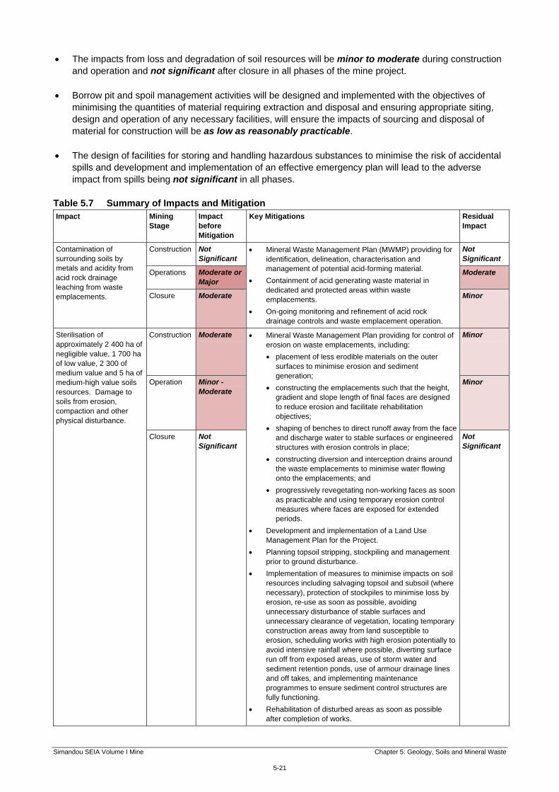
Table 5.7 Summary of Impacts and Mitigation Impact Mining
Stage Impact before Mitigation
Key Mitigations Residual Impact
Contamination of surrounding soils by metals and acidity from acid rock drainage leaching from waste emplacements.
Construction Not Significant
Mineral Waste Management Plan (MWMP) providing for identification, delineation, characterisation and management of potential acid-forming material.
Containment of acid generating waste material in dedicated and protected areas within waste emplacements.
On-going monitoring and refinement of acid rock drainage controls and waste emplacement operation.
Not Significant
Operations Moderate or Major
Moderate
Closure Moderate Minor
Sterilisation of approximately 2 400 ha of negligible value, 1 700 ha of low value, 2 300 of medium value and 5 ha of medium-high value soils resources. Damage to soils from erosion, compaction and other physical disturbance.
Construction Moderate Mineral Waste Management Plan providing for control of erosion on waste emplacements, including:
placement of less erodible materials on the outer surfaces to minimise erosion and sediment generation;
constructing the emplacements such that the height, gradient and slope length of final faces are designed to reduce erosion and facilitate rehabilitation objectives;
shaping of benches to direct runoff away from the face and discharge water to stable surfaces or engineered structures with erosion controls in place;
constructing diversion and interception drains around the waste emplacements to minimise water flowing onto the emplacements; and
progressively revegetating non-working faces as soon as practicable and using temporary erosion control measures where faces are exposed for extended periods.
Development and implementation of a Land Use Management Plan for the Project.
Planning topsoil stripping, stockpiling and management prior to ground disturbance.
Implementation of measures to minimise impacts on soil resources including salvaging topsoil and subsoil (where necessary), protection of stockpiles to minimise loss by erosion, re-use as soon as possible, avoiding unnecessary disturbance of stable surfaces and unnecessary clearance of vegetation, locating temporary construction areas away from land susceptible to erosion, scheduling works with high erosion potentially to avoid intensive rainfall where possible, diverting surface run off from exposed areas, use of storm water and sediment retention ponds, use of armour drainage lines and off takes, and implementing maintenance programmes to ensure sediment control structures are fully functioning.
Rehabilitation of disturbed areas as soon as possible after completion of works.
Minor
Operation Minor - Moderate
Minor
Closure Not Significant
Not Significant

Simandou SEIA Volume I Mine Chapter 5: Geology, Soils and Mineral Waste
5-22
Impact Mining Stage
Impact before Mitigation
Key Mitigations Residual Impact
Impacts on soils and other land-based resources from extraction of material from borrow pits and disposal of surplus spoil.
Construction Not known but is likely to be Significant
The Project will adopt a range of measures to minimise the adverse impacts from sourcing of material a=for construction and disposal of surplus spoil.
Design of mine to minimise need for sourcing and disposal of material outside the main mine site area.
Borrow pits will be used for short term extraction of soft materials required solely for the purpose of the Project.
Appropriate siting of borrow pits and spoil disposal sites.
Good practice in design and operation of borrow pits and spoil disposal sites in accordance with all required permits and approvals.
Minor or Not Significant
Contamination of soils by spills during construction, operation and closure.
Construction Minor Design for safe storage of hazardous materials, including bunding.
Development and implementation of an Emergency Prevention, Preparedness and Response Plan for construction, operation and closure.
Not Significant
Operations and Closure
Minor Not Significant