Embed Size (px)
Citation preview
----
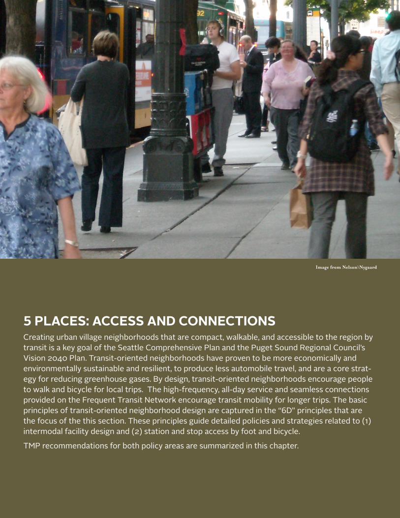
Image from Nelson\Nygaard
5 PLACES: ACCESS AND CONNECTIONSCreating urban village neighborhoods that are compact, walkable, and accessible to the region by transit is a key goal of the Seattle Comprehensive Plan and the Puget Sound Regional Council’s Vision 2040 Plan. Transit-oriented neighborhoods have proven to be more economically and environmentally sustainable and resilient, to produce less automobile travel, and are a core strat-egy for reducing greenhouse gases. By design, transit-oriented neighborhoods encourage people to walk and bicycle for local trips. The high-frequency, all-day service and seamless connections provided on the Frequent Transit Network encourage transit mobility for longer trips. The basic principles of transit-oriented neighborhood design are captured in the “6D” principles that are the focus of the this section. These principles guide detailed policies and strategies related to (1) intermodal facility design and (2) station and stop access by foot and bicycle.
TMP recommendations for both policy areas are summarized in this chapter.
Chapter 5 — Access and Connections
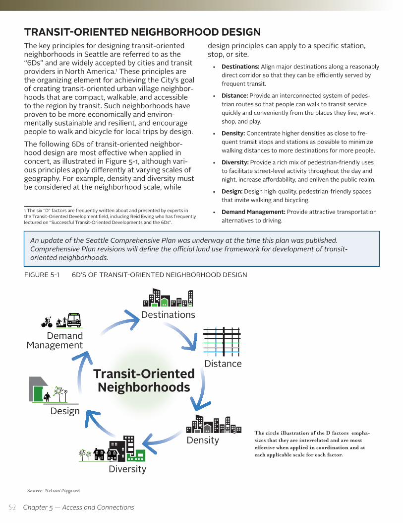
TRANSIT-ORIENTED NEIGHBORHOOD DESIGNThe key principles for designing transit-oriented neighborhoods in Seattle are referred to as the “6Ds” and are widely accepted by cities and transit providers in North America.1 These principles are the organizing element for achieving the City’s goal of creating transit-oriented urban village neighbor-hoods that are compact, walkable, and accessible to the region by transit. Such neighborhoods have proven to be more economically and environ-mentally sustainable and resilient, and encourage people to walk and bicycle for local trips by design.The following 6Ds of transit-oriented neighbor-hood design are most effective when applied in concert, as illustrated in Figure 5-1, although vari-ous principles apply differently at varying scales of geography. For example, density and diversity must be considered at the neighborhood scale, while
1 The six “D” factors are frequently written about and presented by experts in the Transit-Oriented Development field, including Reid Ewing who has frequently lectured on “Successful Transit-Oriented Developments and the 6Ds”.
design principles can apply to a specific station, stop, or site.
• Destinations: Align major destinations along a reasonably direct corridor so that they can be efficiently served by frequent transit.
• Distance: Provide an interconnected system of pedes-trian routes so that people can walk to transit service quickly and conveniently from the places they live, work, shop, and play.
• Density: Concentrate higher densities as close to fre-quent transit stops and stations as possible to minimize walking distances to more destinations for more people.
• Diversity: Provide a rich mix of pedestrian-friendly uses to facilitate street-level activity throughout the day and night, increase affordability, and enliven the public realm.
• Design: Design high-quality, pedestrian-friendly spaces that invite walking and bicycling.
• Demand Management: Provide attractive transportation alternatives to driving.
FIGURE 5-1 6D’S OF TRANSIT-ORIENTED NEIGHBORHOOD DESIGN
Source: Nelson\Nygaard
Distance
Density
Design
Diversity
Demand Management
Destinations
Quality Environment
Transit-OrientedNeighborhoods
The circle illustration of the D factors empha-sizes that they are interrelated and are most effective when applied in coordination and at each applicable scale for each factor.
An update of the Seattle Comprehensive Plan was underway at the time this plan was published. Comprehensive Plan revisions will define the official land use framework for development of transit-oriented neighborhoods.
5-2
Seattle Transit Master Plan
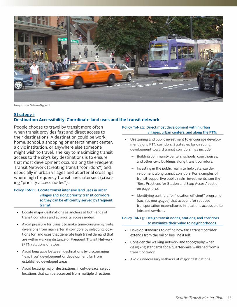
Image from Nelson\Nygaard
Strategy 1 Destination Accessibility: Coordinate land uses and the transit networkPeople choose to travel by transit more often when transit provides fast and direct access to their destinations. A destination could be work, home, school, a shopping or entertainment center, a civic institution, or anywhere else someone might wish to travel. The key to maximizing transit access to the city’s key destinations is to ensure that most development occurs along the Frequent Transit Network (creating transit “corridors”) and especially in urban villages and at arterial crossings where high frequency transit lines intersect (creat-ing “priority access nodes”). Policy ToN1.1: Locate transit intensive land uses in urban
villages and along priority transit corridors so they can be efficiently served by frequent transit.
• Locate major destinations as anchors at both ends of transit corridors and at priority access nodes.
• Avoid pressure for transit to make time-consuming route diversions from main arterial corridors by selecting loca-tions for land uses that generate high travel demand that are within walking distance of Frequent Transit Network (FTN) stations or stops.
• Avoid long gaps between destinations by discouraging “leap frog” development or development far from established developed areas.
• Avoid locating major destinations in cul-de-sacs: select locations that can be accessed from multiple directions.
Policy ToN1.2: Direct most development within urban villages, urban centers, and along the FTN.
• Use zoning and public investment to encourage develop-ment along FTN corridors. Strategies for directing development toward transit corridors may include:
Building community centers, schools, courthouses, and other civic buildings along transit corridors.
Investing in the public realm to help catalyze de-velopment along transit corridors. For examples of transit-supportive public realm investments, see the ‘Best Practices for Station and Stop Access’ section on page 5-32.
Identifying partners for “location efficient” programs (such as mortgages) that account for reduced transportation expenditures in locations accessible to jobs and services.
Policy ToN1.3: Design transit nodes, stations, and corridors to maximize their value to neighborhoods.
• Develop standards to define how far a transit corridor extends from the rail or bus line itself.
• Consider the walking network and topography when designing standards for a quarter-mile walkshed from a transit corridor.
• Avoid unnecessary setbacks at major destinations.
5-3
Chapter 5 — Access and Connections
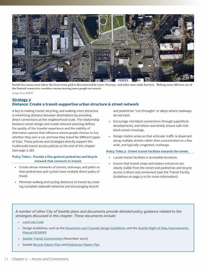
Seattle has many areas where the local street grid is disconnected by water, freeways, and other man made barriers. Making most efficient use of the limited connective corridors means moving more people on transit.
Image from SDOT
Strategy 2 Distance: Create a transit-supportive urban structure & street networkA key to making transit, bicycling, and walking more attractive is minimizing distance between destinations by providing direct connections at the neighborhood scale. The relationship between street design and modal network planning defines the quality of the traveler experience and the viability of alternative options that influence where people choose to live, whether they own a car, and how they travel for different types of trips. These policies and strategies directly support the multimodal transit access policies at the end of this chapter (see page 5-36).
Policy ToN2.1: Provide a fine-grained pedestrian and bicycle network that connects to transit.
• Create dense networks of streets, stairways, and paths so that pedestrians and cyclists have multiple direct paths of travel.
• Minimize walking and cycling distances to transit by creat-ing complete sidewalk networks and encouraging bicycle
and pedestrian “cut-throughs” or alleys where roadways do not exist.
• Encourage mid-block connections through superblock developments, and where warranted, ensure safe mid-block street crossings.
• Design station areas so that vehicular traffic is dispersed along multiple streets rather than concentrated on a few wide, and typically congested, roadways.
Policy ToN2.2: Orient transit facilities towards the street.
• Locate transit facilities in accessible locations.
• Ensure that transit stops and station entrances are clearly visible from the street and pedestrian and bicycle access is direct and convenient (see the Transit Facility Guidelines on page 5-10 for more information).
A number of other City of Seattle plans and documents provide detailed policy guidance related to the strategies discussed in this chapter. These documents include:
• Land Use Code
• Design Guidelines, such as the Downtown and Citywide Design Guidelines, and the Seattle Right-of-Way Improvements Manual (ROWIM)
• Seattle Transit Communities (November 2010)
• Seattle Bicycle Master Plan and Pedestrian Master Plan
5-4
Seattle Transit Master Plan
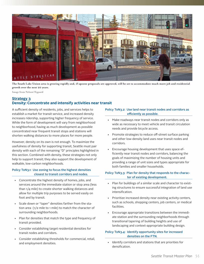
The South Lake Union area is growing rapidly and, if upzone proposals are approved, will be set to accommodate much more job and residential growth over the next 20 years.
Image from Nelson\Nygaard
Strategy 3 Density: Concentrate and intensify activities near transitA sufficient density of residents, jobs, and services helps to establish a market for transit service, and increased density increases ridership, supporting higher frequency of service. While the form of development will vary from neighborhood to neighborhood, having as much development as possible concentrated near frequent transit stops and stations will shorten walking distances to more places for more people.
However, density on its own is not enough. To maximize the usefulness of density for supporting transit, Seattle must pair density with each of the remaining “D” principles highlighted in this section. Combined with density, these strategies not only help to support transit; they also support the development of walkable, low-carbon neighborhoods.
Policy ToN3.1: Use zoning to focus the highest densities closest to transit corridors and nodes.
• Concentrate the highest density of homes, jobs, and services around the immediate station or stop area (less than 1/4 mile) to create shorter walking distances and allow for multiple trip purposes to be served easily on foot and by transit.
• Scale down or “taper” densities farther from the sta-tion area (1/2 mile to 1 mile) to match the character of surrounding neighborhoods.
• Plan for densities that match the type and frequency of transit provided.
• Consider establishing target residential densities for transit nodes and corridors.
• Consider establishing thresholds for commercial, retail, and employment densities.
Policy ToN3.2: Use land near transit nodes and corridors as efficiently as possible.
• Make roadways near transit nodes and corridors only as wide as necessary to meet vehicle and transit circulation needs and provide bicycle access.
• Promote strategies to reduce off-street surface parking and other low-density land uses near transit nodes and corridors.
• Encourage housing development that uses space ef-ficiently near transit nodes and corridors, balancing the goals of maximizing the number of housing units and providing a range of unit sizes and types appropriate for both families and smaller households.
Policy ToN3.3: Plan for density that responds to the charac-ter of existing development.
• Plan for buildings of a similar scale and character to exist-ing structures to ensure successful integration of land use intensification.
• Prioritize increased density near existing activity centers, such as schools, shopping centers, job centers, or medical facilities.
• Encourage appropriate transitions between the immedi-ate station and the surrounding neighborhoods through transitional tapering of building heights and use of landscaping and context-appropriate building design.
Policy ToN3.4: Identify opportunity sites for increased densities on the FTN.
• Identify corridors and stations that are priorities for densification.
5-5
Chapter 5 — Access and Connections
• Work with owners of vacant and likely redevelopment parcels in station areas and priority transit corridors to encourage infill development.
• Encourage partnerships with transit agencies to catalyze TOD projects through property acquisition and/or redevelopment.
• Ensure public agencies do not hold property where redevelopment is feasible.
• Explore the potential of converting existing surface parking lots into future redevelopment sites.
• Focus development at the best-connected transit nodes.
• Encourage development opportunity at modal inter-changes and station areas.
• Encourage the location of major destinations at the intersection of transit lines.
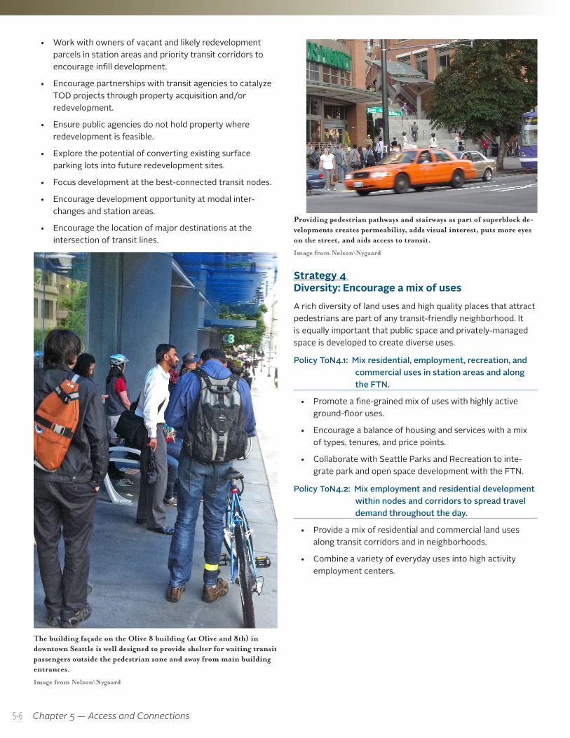
Providing pedestrian pathways and stairways as part of superblock de-velopments creates permeability, adds visual interest, puts more eyes on the street, and aids access to transit.
Image from Nelson\Nygaard
Strategy 4 Diversity: Encourage a mix of usesA rich diversity of land uses and high quality places that attract pedestrians are part of any transit-friendly neighborhood. It is equally important that public space and privately-managed space is developed to create diverse uses.
Policy ToN4.1: Mix residential, employment, recreation, and commercial uses in station areas and along the FTN.
• Promote a fine-grained mix of uses with highly active ground-floor uses.
• Encourage a balance of housing and services with a mix of types, tenures, and price points.
• Collaborate with Seattle Parks and Recreation to inte-grate park and open space development with the FTN.
Policy ToN4.2: Mix employment and residential development within nodes and corridors to spread travel demand throughout the day.
• Provide a mix of residential and commercial land uses along transit corridors and in neighborhoods.
• Combine a variety of everyday uses into high activity employment centers.
The building façade on the Olive 8 building (at Olive and 8th) in downtown Seattle is well designed to provide shelter for waiting transit passengers outside the pedestrian zone and away from main building entrances.
Image from Nelson\Nygaard
5-6
Seattle Transit Master Plan
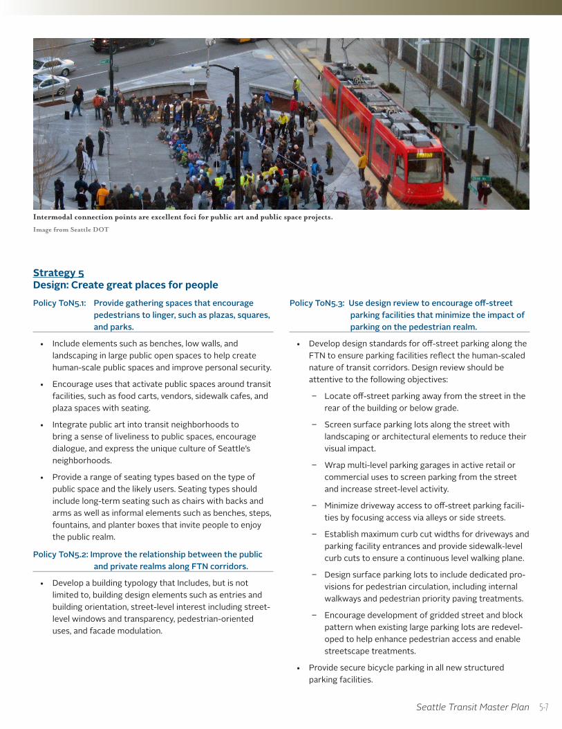
Intermodal connection points are excellent foci for public art and public space projects.
Image from Seattle DOT
Strategy 5 Design: Create great places for peoplePolicy ToN5.1: Provide gathering spaces that encourage
pedestrians to linger, such as plazas, squares, and parks.
• Include elements such as benches, low walls, and landscaping in large public open spaces to help create human-scale public spaces and improve personal security.
• Encourage uses that activate public spaces around transit facilities, such as food carts, vendors, sidewalk cafes, and plaza spaces with seating.
• Integrate public art into transit neighborhoods to bring a sense of liveliness to public spaces, encourage dialogue, and express the unique culture of Seattle’s neighborhoods.
• Provide a range of seating types based on the type of public space and the likely users. Seating types should include long-term seating such as chairs with backs and arms as well as informal elements such as benches, steps, fountains, and planter boxes that invite people to enjoy the public realm.
Policy ToN5.2: Improve the relationship between the public and private realms along FTN corridors.
• Develop a building typology that Includes, but is not limited to, building design elements such as entries and building orientation, street-level interest including street-level windows and transparency, pedestrian-oriented uses, and facade modulation.
Policy ToN5.3: Use design review to encourage off-street parking facilities that minimize the impact of parking on the pedestrian realm.
• Develop design standards for off-street parking along the FTN to ensure parking facilities reflect the human-scaled nature of transit corridors. Design review should be attentive to the following objectives:
Locate off-street parking away from the street in the rear of the building or below grade.
Screen surface parking lots along the street with landscaping or architectural elements to reduce their visual impact.
Wrap multi-level parking garages in active retail or commercial uses to screen parking from the street and increase street-level activity.
Minimize driveway access to off-street parking facili-ties by focusing access via alleys or side streets.
Establish maximum curb cut widths for driveways and parking facility entrances and provide sidewalk-level curb cuts to ensure a continuous level walking plane.
Design surface parking lots to include dedicated pro-visions for pedestrian circulation, including internal walkways and pedestrian priority paving treatments.
Encourage development of gridded street and block pattern when existing large parking lots are redevel-oped to help enhance pedestrian access and enable streetscape treatments.
• Provide secure bicycle parking in all new structured parking facilities.
5-7
Chapter 5 — Access and Connections
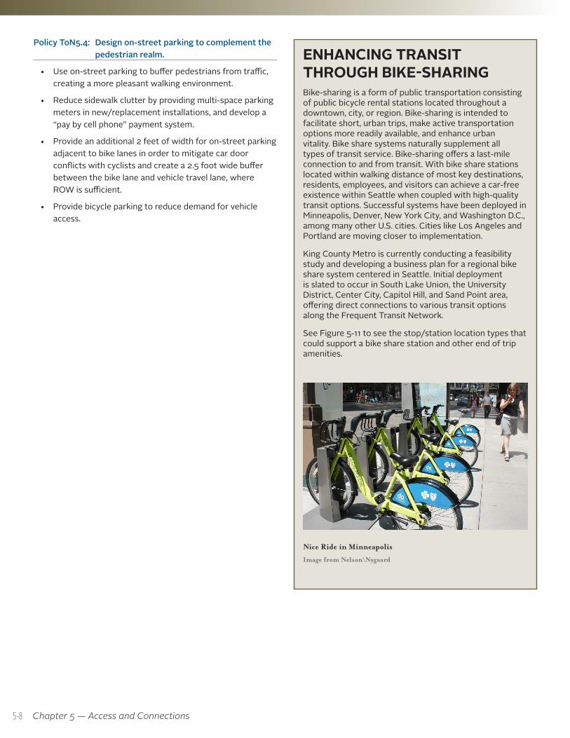
ENHANCING TRANSIT THROUGH BIKE-SHARINGBike-sharing is a form of public transportation consisting of public bicycle rental stations located throughout a downtown, city, or region. Bike-sharing is intended to facilitate short, urban trips, make active transportation options more readily available, and enhance urban vitality. Bike share systems naturally supplement all types of transit service. Bike-sharing offers a last-mile connection to and from transit. With bike share stations located within walking distance of most key destinations, residents, employees, and visitors can achieve a car-free existence within Seattle when coupled with high-quality transit options. Successful systems have been deployed in Minneapolis, Denver, New York City, and Washington D.C., among many other U.S. cities. Cities like Los Angeles and Portland are moving closer to implementation.
King County Metro is currently conducting a feasibility study and developing a business plan for a regional bike share system centered in Seattle. Initial deployment is slated to occur in South Lake Union, the University District, Center City, Capitol Hill, and Sand Point area, offering direct connections to various transit options along the Frequent Transit Network.
See Figure 5-11 to see the stop/station location types that could support a bike share station and other end of trip amenities.
Nice Ride in Minneapolis
Image from Nelson\Nygaard
Policy ToN5.4: Design on-street parking to complement the pedestrian realm.
• Use on-street parking to buffer pedestrians from traffic, creating a more pleasant walking environment.
• Reduce sidewalk clutter by providing multi-space parking meters in new/replacement installations, and develop a “pay by cell phone” payment system.
• Provide an additional 2 feet of width for on-street parking adjacent to bike lanes in order to mitigate car door conflicts with cyclists and create a 2.5 foot wide buffer between the bike lane and vehicle travel lane, where ROW is sufficient.
• Provide bicycle parking to reduce demand for vehicle access.
5-8
Seattle Transit Master Plan
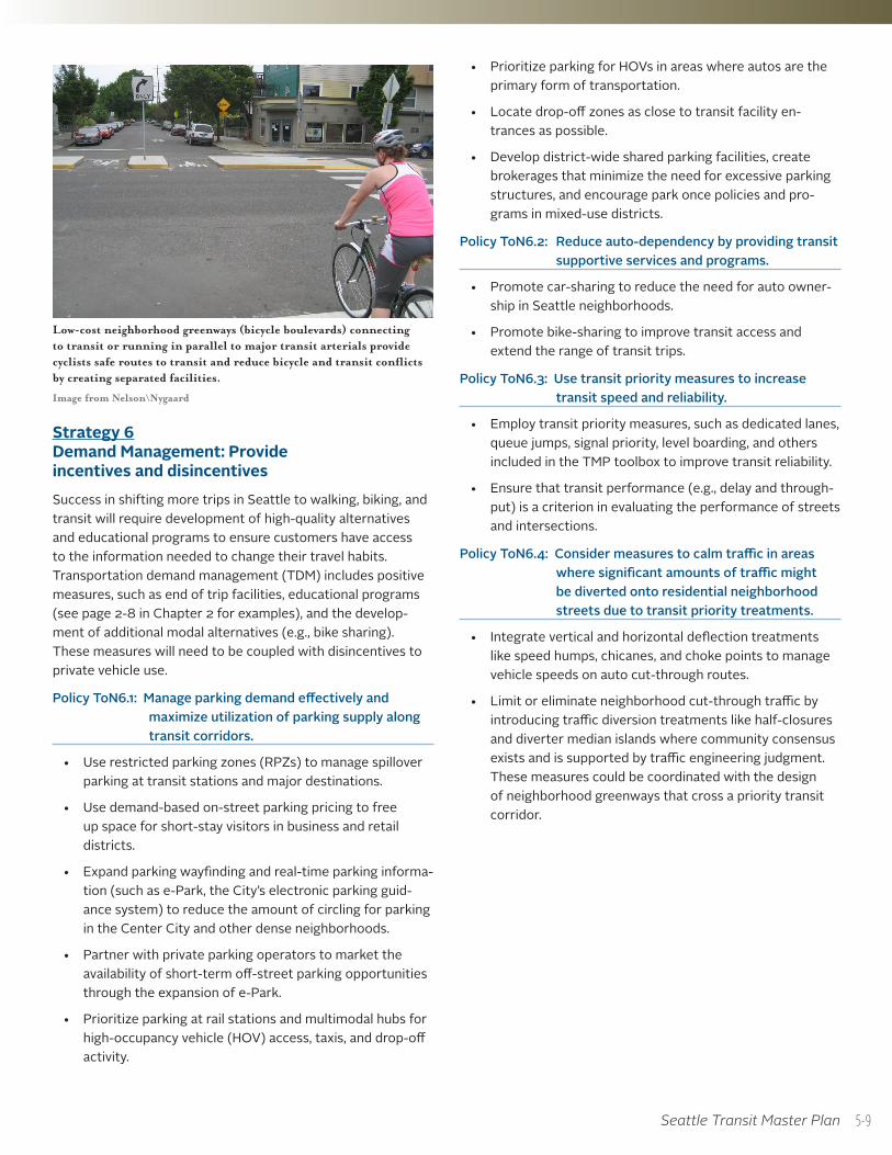
Low-cost neighborhood greenways (bicycle boulevards) connecting to transit or running in parallel to major transit arterials provide cyclists safe routes to transit and reduce bicycle and transit conflicts by creating separated facilities.
Image from Nelson\Nygaard
Strategy 6 Demand Management: Provide incentives and disincentivesSuccess in shifting more trips in Seattle to walking, biking, and transit will require development of high-quality alternatives and educational programs to ensure customers have access to the information needed to change their travel habits. Transportation demand management (TDM) includes positive measures, such as end of trip facilities, educational programs (see page 2-8 in Chapter 2 for examples), and the develop-ment of additional modal alternatives (e.g., bike sharing). These measures will need to be coupled with disincentives to private vehicle use.
Policy ToN6.1: Manage parking demand effectively and maximize utilization of parking supply along transit corridors.
• Use restricted parking zones (RPZs) to manage spillover parking at transit stations and major destinations.
• Use demand-based on-street parking pricing to free up space for short-stay visitors in business and retail districts.
• Expand parking wayfinding and real-time parking informa-tion (such as e-Park, the City’s electronic parking guid-ance system) to reduce the amount of circling for parking in the Center City and other dense neighborhoods.
• Partner with private parking operators to market the availability of short-term off-street parking opportunities through the expansion of e-Park.
• Prioritize parking at rail stations and multimodal hubs for high-occupancy vehicle (HOV) access, taxis, and drop-off activity.
• Prioritize parking for HOVs in areas where autos are the primary form of transportation.
• Locate drop-off zones as close to transit facility en-trances as possible.
• Develop district-wide shared parking facilities, create brokerages that minimize the need for excessive parking structures, and encourage park once policies and pro-grams in mixed-use districts.
Policy ToN6.2: Reduce auto-dependency by providing transit supportive services and programs.
• Promote car-sharing to reduce the need for auto owner-ship in Seattle neighborhoods.
• Promote bike-sharing to improve transit access and extend the range of transit trips.
Policy ToN6.3: Use transit priority measures to increase transit speed and reliability.
• Employ transit priority measures, such as dedicated lanes, queue jumps, signal priority, level boarding, and others included in the TMP toolbox to improve transit reliability.
• Ensure that transit performance (e.g., delay and through-put) is a criterion in evaluating the performance of streets and intersections.
Policy ToN6.4: Consider measures to calm traffic in areas where significant amounts of traffic might be diverted onto residential neighborhood streets due to transit priority treatments.
• Integrate vertical and horizontal deflection treatments like speed humps, chicanes, and choke points to manage vehicle speeds on auto cut-through routes.
• Limit or eliminate neighborhood cut-through traffic by introducing traffic diversion treatments like half-closures and diverter median islands where community consensus exists and is supported by traffic engineering judgment. These measures could be coordinated with the design of neighborhood greenways that cross a priority transit corridor.
5-9
Chapter 5 — Access and Connections
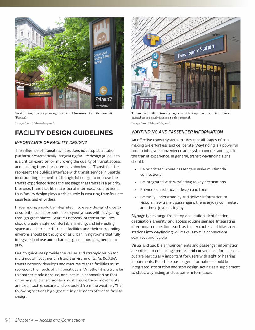
WAYFINDING AND PASSENGER INFORMATION
An effective transit system ensures that all stages of trip-making are effortless and deliberate. Wayfinding is a powerful tool to integrate convenience and system understanding into the transit experience. In general, transit wayfinding signs should:
• Be prioritized where passengers make multimodal connections
• Be integrated with wayfinding to key destinations
• Provide consistency in design and tone
• Be easily understood by and deliver information to visitors, new transit passengers, the everyday commuter, and those just passing by
Signage types range from stop and station identification, destination, amenity, and access routing signage. Integrating intermodal connections such as feeder routes and bike share stations into wayfinding will make last-mile connections seamless and legible.
Visual and audible announcements and passenger information are critical to enhancing comfort and convenience for all users, but are particularly important for users with sight or hearing impairments. Real-time passenger information should be integrated into station and stop design, acting as a supplement to static wayfinding and customer information.
Tunnel identification signage could be improved to better direct casual users and visitors to the tunnel.
Image from Nelson\Nygaard
Wayfinding directs passengers to the Downtown Seattle Transit Tunnel.
Image from Nelson\Nygaard
FACILITY DESIGN GUIDELINES IMPORTANCE OF FACILITY DESIGN?
The influence of transit facilities does not stop at a station platform. Systematically integrating facility design guidelines is a critical exercise for improving the quality of transit access and building transit-oriented neighborhoods. Transit facilities represent the public’s interface with transit service in Seattle; incorporating elements of thoughtful design to improve the transit experience sends the message that transit is a priority. Likewise, transit facilities are loci of intermodal connections, thus facility design plays a critical role in ensuring transfers are seamless and effortless.
Placemaking should be integrated into every design choice to ensure the transit experience is synonymous with navigating through great places. Seattle’s network of transit facilities should create a safe, comfortable, inviting, and interesting space at each trip end. Transit facilities and their surrounding environs should be thought of as urban living rooms that fully integrate land use and urban design, encouraging people to stay.
Design guidelines provide the values and strategic vision for multimodal investment in transit environments. As Seattle’s transit network develops and matures, transit facilities must represent the needs of all transit users. Whether it is a transfer to another mode or route, or a last-mile connection on foot or by bicycle, transit facilities must ensure these movements are clear, tactile, secure, and protected from the weather. The following sections highlight the key elements of transit facility design.
5-10
Seattle Transit Master Plan
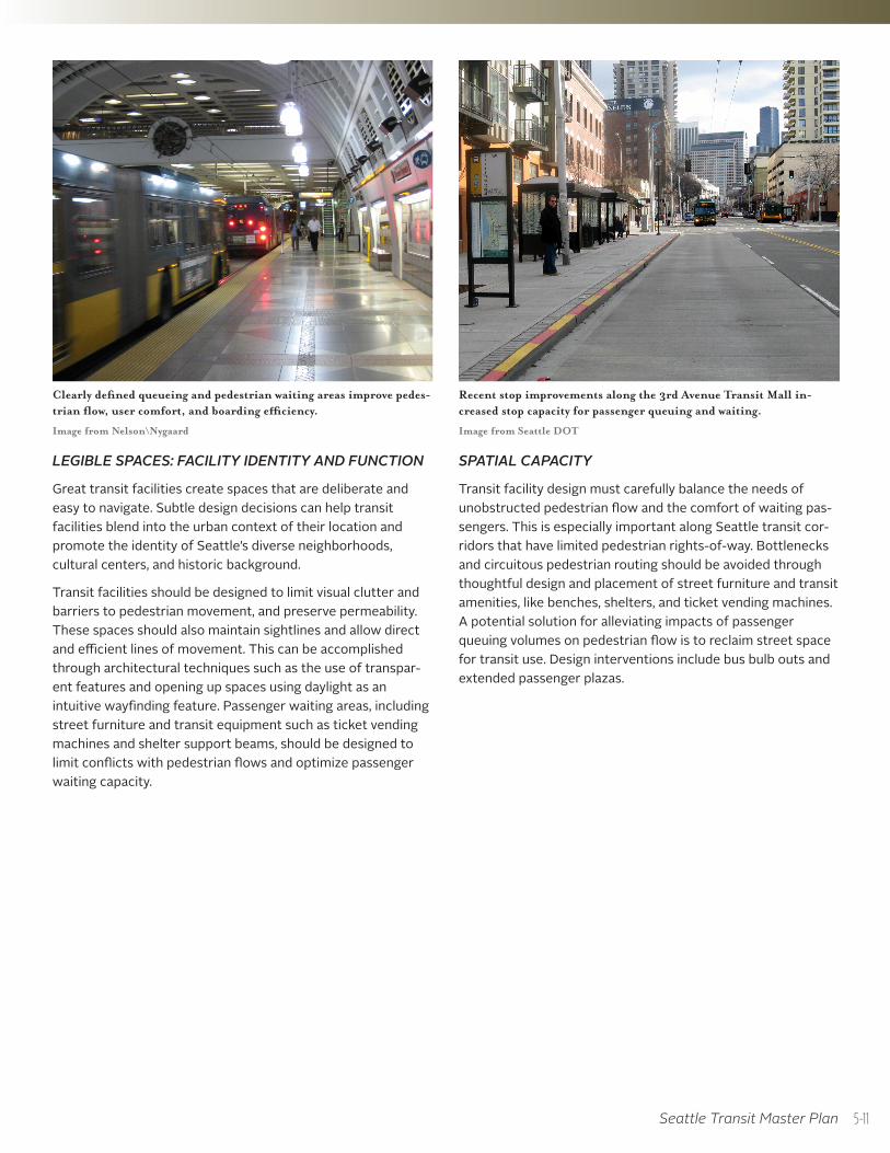
LEGIBLE SPACES: FACILITY IDENTITY AND FUNCTION
Great transit facilities create spaces that are deliberate and easy to navigate. Subtle design decisions can help transit facilities blend into the urban context of their location and promote the identity of Seattle’s diverse neighborhoods, cultural centers, and historic background.
Transit facilities should be designed to limit visual clutter and barriers to pedestrian movement, and preserve permeability. These spaces should also maintain sightlines and allow direct and efficient lines of movement. This can be accomplished through architectural techniques such as the use of transpar-ent features and opening up spaces using daylight as an intuitive wayfinding feature. Passenger waiting areas, including street furniture and transit equipment such as ticket vending machines and shelter support beams, should be designed to limit conflicts with pedestrian flows and optimize passenger waiting capacity.
SPATIAL CAPACITY
Transit facility design must carefully balance the needs of unobstructed pedestrian flow and the comfort of waiting pas-sengers. This is especially important along Seattle transit cor-ridors that have limited pedestrian rights-of-way. Bottlenecks and circuitous pedestrian routing should be avoided through thoughtful design and placement of street furniture and transit amenities, like benches, shelters, and ticket vending machines. A potential solution for alleviating impacts of passenger queuing volumes on pedestrian flow is to reclaim street space for transit use. Design interventions include bus bulb outs and extended passenger plazas.
Clearly defined queueing and pedestrian waiting areas improve pedes-trian flow, user comfort, and boarding efficiency.
Image from Nelson\Nygaard
Recent stop improvements along the 3rd Avenue Transit Mall in-creased stop capacity for passenger queuing and waiting.
Image from Seattle DOT
5-11
Chapter 5 — Access and Connections
UNIVERSAL ACCESSIBILITY
Providing transit services that are universally accessible expands personal mobility, independence, and transportation affordability. Discrimination by design must be actively avoided as transit facilities are built or reconstructed. Several con-siderations should be made as transit facilities are designed, including:
• Minimal level changes in multi-floor facilities and direct access to elevators and escalators, where applicable
• Direct ramp access and blended curb/sidewalk transitions at the street interface
• Deliberate tactility at conflict zones or abrupt edges
• Level boarding
• Obstacle-free connections to dial-a-ride, taxis, pickup and drop-off points, and park-and-ride lots
Information should also be provided in audio, visual, and tactile formats and consider cultural and language differences as well as accommodate those with restricted mobility and visual ability.
SAFETY AND SECURITY
Transit facilities should be open, well-lit, and constantly monitored to ensure the transit experience is comfortable at all hours of the day. Incorporating crime prevention through environmental design principles (CPTED), sometimes also referred to as defensible design, into transit facility design increases both real and perceived safety. These principles include: ensuring spaces are visible to others and well lit, delineating public and private space, managing access portals, and ensuring facilities are regularly maintained and cleaned.
Natural surveillance through transparent design and active streetscapes maximizes visibility and deters the threat of crime. Lighting plays a central role in maintaining pleasant transit environments. Natural lighting and illumination fac-tor into passenger safety, transparency, monitoring, and facility legibility. Lighting should be consistently distributed throughout transit spaces and the exterior public realm so that navigating spaces is enjoyable and stress-free. Public art should be used to create a sense of pride and a community asset.
Facility design should allow transit police ease of access and open views of station property. Where natural surveillance is infeasible, the use of CCTV (closed circuit TV surveillance) should be considered to reinforce the intolerance of criminal activity at transit stations.
Electronic lift for mobility devices.
Image from Nelson\Nygaard
Public art reinforces a sense of ownership and pride.
Image from Flickr user orcmid
5-12
Seattle Transit Master Plan
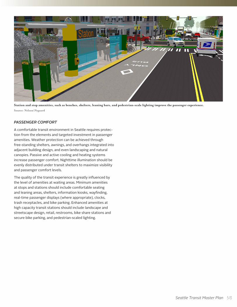
PASSENGER COMFORT
A comfortable transit environment in Seattle requires protec-tion from the elements and targeted investment in passenger amenities. Weather protection can be achieved through free-standing shelters, awnings, and overhangs integrated into adjacent building design, and even landscaping and natural canopies. Passive and active cooling and heating systems increase passenger comfort. Nighttime illumination should be evenly distributed under transit shelters to maximize visibility and passenger comfort levels.
The quality of the transit experience is greatly influenced by the level of amenities at waiting areas. Minimum amenities at stops and stations should include comfortable seating and leaning areas, shelters, information kiosks, wayfinding, real-time passenger displays (where appropriate), clocks, trash receptacles, and bike parking. Enhanced amenities at high capacity transit stations should include landscape and streetscape design, retail, restrooms, bike share stations and secure bike parking, and pedestrian-scaled lighting.
Station and stop amenities, such as benches, shelters, leaning bars, and pedestrian-scale lighting improve the passenger experience.
Source: Nelson\Nygaard
5-13
Chapter 5 — Access and Connections
FACILITY DESIGN GUIDELINESLEGIBILITY
• Policy FD1.1: Maximize ease of navigation by providing direct travel paths, strengthening pedestrian sightlines, and limiting visual and physical barriers to movement.
• Policy FD1.2: Integrate passive lighting design to improve visibility and reinforce that each facility is a transparent space.
• Policy FD1.3: Integrate Seattle’s history, diverse cultures, and neighborhood identity in the design of all transit facilities. Transit facilities must seamlessly mold into the urban context of their location.
• Policy FD1.4: Actively pursue the design of shared spaces that fully integrate an open transit environ-ment into the urban fabric and create great transit neighborhoods.
WAYFINDING AND PASSENGER INFORMATION• Policy FD2.1: Ensure that wayfinding is predictable in
design and information dissemination.
• Policy FD2.2: Develop consistent sign design aesthetics using distinct sign types, color schemes, fonts, and symbology.
• Policy FD2.3: Facilitate multimodal connections by directing passengers between modes.
• Policy FD2.4: Expand the scope of transit wayfinding to guide passengers and pedestrians toward station portals, major destinations, bicycle routes, major attrac-tors, and other multimodal connections. Integrated wayfinding should emphasize making intermodal connections simple and quick.
• Policy FD2.5: Coordinate with public transit service providers to develop universal transit wayfinding sign guidelines.
• Policy FD2.6: Avoid visual conflicts with advertising, commercial, and other informational sign types.
SPATIAL CAPACITY • Policy FD3.1: Ensure sidewalks accommodate enough
space for a variety of pedestrian activities, such as sitting/leaning, standing/queuing, and walking.
• Policy FD3.2: Encourage building façade designs that allow waiting passengers to step out of the active zone while providing something to lean or sit on and offering protection against the elements.
• Policy FD3.3: Consider expanding existing passenger facilities where transit facilities have limited passenger
waiting capacity, high boardings, and/or significant pinch points that limit passenger movement.
• Policy FD3.4: Eliminate passenger/pedestrian bottlenecks by locating passenger amenities outside of passenger queuing areas and pedestrian walkways. See section 4.11 of the Seattle Right-of-Way Improvements Manual (ROWIM) for details.
UNIVERSAL ACCESSIBILITY• Policy FD4.1: Reduce the incidences of barriers and
vertical obstructions.
• Policy FD4.2: Limit construction of multi-level transit facilities. If unavoidable, provide elevators, ramps with well designed railings, and/or escalators to facilitate fast and efficient movement of persons with disabilities.
• Policy FD4.3: Ensure all transit facilities incorporate adequate curb ramp, facility ramp, and tactile surface design, as detailed in the forthcoming Public Right-of-Way Accessibility Guidelines (PROWAG section R308), published by the United States Access Board.
• Policy FD4.4: Provide information in a variety of media types to cater to the needs of the visual, hearing, developmental, and mobility-impaired.
SAFETY AND SECURITY• Policy FD5.1: Integrate crime prevention through
environmental design (CPTED) principles into all transit facility design processes. These principles include: ensuring spaces are visible to others and well lit, delineating public and private space, managing access portals, and ensuring facilities are regularly maintained and cleaned.
• Policy FD5.2: Collaborate with law enforcement and emergency response agencies to ensure facilities are effectively monitored. Monitoring should be increased with increased boarding activity.
• Policy FD5.3: Use technology such as CCTV to continu-ally monitor transit facilities.
• Policy FD5.4: Introduce public art installations, sooth-ing music, and other amenities to signal to transit users that transit facilities are community assets and gather-ing places.
• Policy FD5.5: Ensure transit facilities are well-lit with pedestrian-scaled LED lighting during early morning and evening service.
5-14
Seattle Transit Master Plan
PASSENGER COMFORT• Policy FD6.1: Balance the provision of station and stop
amenities without jeopardizing optimal pedestrian flow and the comfort of waiting passengers.
• Policy FD6.2: Provide continuous protection from inclement weather conditions by providing shelters, awnings, overhangs, and canopies.
• Policy FD6.3: Offer a variety of seating and leaning amenities located within passenger waiting areas and outside of pedestrian walkways.
• Policy FD6.4: Design transit facilities to be pleasant gathering places using verdant landscap-ing features, public art installations, and cultural/historical influenced design.
• Policy FD6.5: Activate transit spaces by introduc-ing auxiliary uses into the design of transit facili-ties, such as parks and green space, food service (e.g., food carts), or context-appropriate retail establishment.
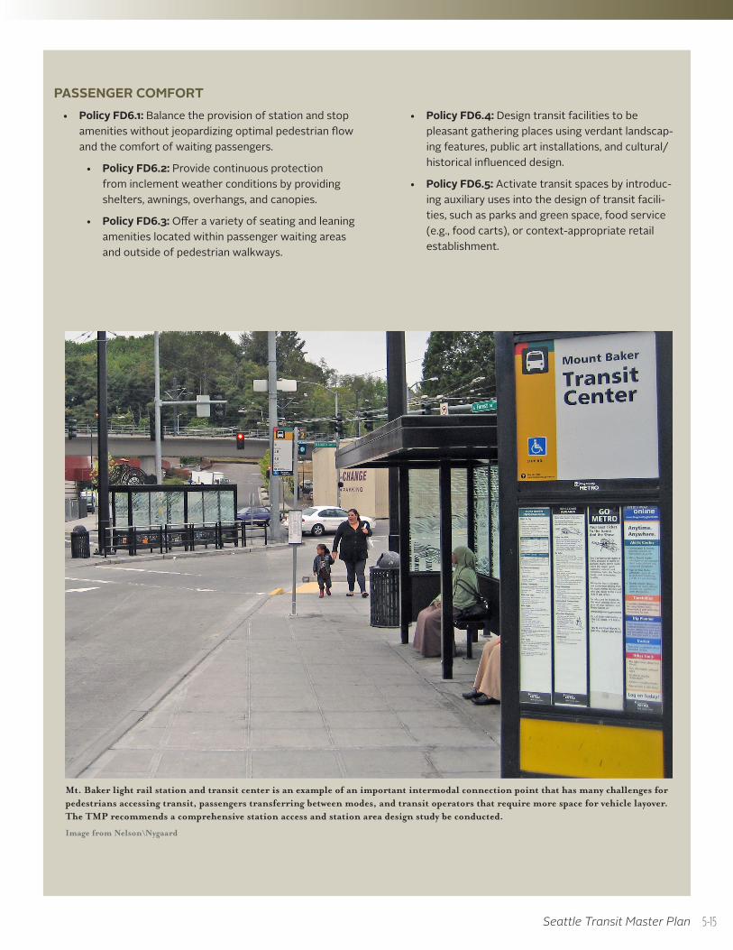
Mt. Baker light rail station and transit center is an example of an important intermodal connection point that has many challenges for pedestrians accessing transit, passengers transferring between modes, and transit operators that require more space for vehicle layover. The TMP recommends a comprehensive station access and station area design study be conducted.
Image from Nelson\Nygaard
5-15
TYPES OF TRANSFER FACILITIES AND KEY DESIGN ELEMENTS
Seattle has a number of different types of places where passengers transfer; each requires special design features to ensure intermodal connections are seamless. They include:
• Multimodal Hubs: Regional intermodal transfer centers that are designed to accommodate substantial passenger volumes, facilitate effortless transfer between modes (including Frequent and High Capacity Transit), and are the city’s most significant intermodal connection points. These facilities are often the termini of several transit lines. Multimodal hubs are primarily located in the Center City and areas with transit-supportive land use, and are prime locations for transit-oriented development. Multimodal hubs typically contain the following design elements:
Fully enclosed stations or waiting areas, including real-time information displays, pedestrian-scale lighting, transparent shelters, and ORCA readers
On- and/or off-street bus layover space
Taxi and pick-up/drop-off zones
Restricted access for non-transit modes
Chapter 5 — Access and Connections
MAKING TRANSIT CONNECTIONS IN SEATTLEExchange points, or intermodal connections, are the interface between transit services and the public realm; therefore, ensuring connections are seamless is a key requirement to encourage new ridership. Intermodal exchanges must provide safe, comfortable, and efficient transfers between transporta-tion modes. Based on the facility design policies described earlier in this chapter, passengers should feel comfortable navigating between modes at a transfer facility. The level of integrated facility design depends on the type of transfer facilities.
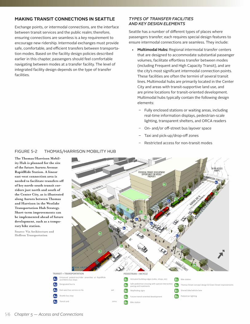
The Thomas/Harrison Mobil-ity Hub is planned for the site of the future Aurora Avenue RapidRide Station. A linear east-west connection area is needed to facilitate transfers off of key north-south transit cor-ridors just north and south of the Center City, as is illustrated along Aurora between Thomas and Harrison in the Westlake Transportation Hub Strategy. Short-term improvements can be implemented ahead of future development, such as a tempo-rary bike station.
Source: Via Architecture and Heffron Transportation
FIGURE 5-2 THOMAS/HARRISON MOBILITY HUB
SOUTH LAKE UNION / UPTOWN TRIANGLE MOBILITY PLAN16
7
T1: THOMAS / HARRISON MOBILITY HUB
A1A1
A2
A2
A2B1
B1
B1
B1
B1
A4
A4
B2
B2
A5
A5
B3B3
B3
A3
A3
B4
B4
B4
B5
B5
B7
B7
B8
B8
B8
B8
B8
B6
B6
Enhanced pedestrian/rider amenities at RapidRide and Metro bus stops
Most of the improvements can be implemented ahead of future development; a temporary bike station could be included at the corner to help establish a “Sense of Place”
Designated bus lanes and priority signals
Activated building edges (cafes, shops, etc)
Shuttle bus stop
Safe pedestrian crossing with special intersection paving and treatments
Transit and community information kiosk
Wayfinding signs
East-west bus service on Harrison Street
Future transit-oriented development
Bike station
Shared bike/vehicle lane
Pedestrian lighting
Thomas Street concept design & Green Street improvements
SR-99 ACCESSRAMPS
POTENTIAL PRIVATE DEVELOPMENT OPPORTUNITY ON WSDOT
PROPERTY
THOMAS STREET
AURORA AVE N
(to be re
named 7T
H AVENUE N
)
6TH AVENUE N
CREATE HUBS FOR MODE TRANSFERT1: Thomas/Harrison Mobility Hub -- This hub would be at the future Aurora Avenue RapidRide Station, between Harrison and Thomas Streets, where regional RapidRide service would meet local transit service. This node also connects with the Lake-to-Bay Loop trail, the Thomas Street Green Street and new east-west bike routes.
TRANSIT + TRANSPORTATION
PEDESTRIAN + BICYCLE
HARRISON STREET
N
INTERIM USE ON WSDOT PROPERTY
5-16
Enhanced pedestrian and bicycle access features within a 1/2-mile radius of the facility for walking and up to three miles for biking
• Transportation Centers: Central locations, primar-ily centered in hub urban villages, where a variety of transportation linkages convene. Transportation centers often concentrate several transit lines with high rates of transfers. These facilities are also supplemented by bike facilities, car-sharing and taxi bay facilities, destination amenities for bicyclists making regional trips, and high-quality passenger amenities. Figure 5-2 illustrates such a facility along Aurora between Thomas and Harrison.
• High Capacity Transit Stations: Standalone rail and bus station facilities designed to facilitate intermodal connec-tions between light rail, rapid streetcar, BRT, and Center City streetcar boarding and alightings. The nature and level of passenger amenities at each station varies.
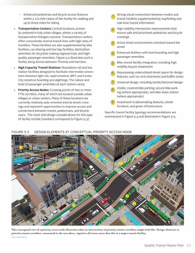
• Priority Access Nodes: Crossing points of two or more FTN corridors, many of which are located outside urban villages or urban centers. Many of these locations are currently relatively auto-oriented arterial street cross-ings and represent opportunities to improve access and connections between transit, pedestrians, and bicycle users. The most vital design considerations for this type of facility include (numbers correspond to Figure 5-3):
Strong visual connections between modes and transit facilities supplemented by wayfinding and real-time transit information
High visibility intersection improvements that ensure safe and prioritized pedestrian and bicycle crossings
Active street environments oriented toward the street
Enhanced shelters with level boarding and high passenger amenities
Bike-transit facility integration, including high visibility bicycle treatments
Repurposing underutilized street space for design features, such as curb extensions and buffer zones
Universal design, including tactile/textured design
Visible, covered bike parking, secure bike park-ing (where appropriate), and bike share station (where appropriate)
Investment in placemaking features, street furniture, and green infrastructure
Specific transit facility typology recommendations are summarized in Figure 5-4 and illustrated in Figure 5-5.
1
2
3
4
5
6
7
8
9
Seattle Transit Master Plan
1
2
3
47
8
4
5
56
9
9
FIGURE 5-3 DESIGN ELEMENTS AT CONCEPTUAL PRIORITY ACCESS NODE
This conceptual view of a priority access node illustrates what an intersection of priority transit corridors might look like. Design elements at priority transit corridors, annotated in the text above, signal to all street users that this is a major transit facility. Source: Nelson\Nygaard
5-17
PRIORITIES FOR TRANSFER AND INTERMODAL FACILITY DEVELOPMENT
When developing new transfer facilities or improving existing intermodal connections, the City should utilize the Facility Design Guidelines developed earlier in this Chapter. This will ensure connections are made as efficiently and effortlessly as possible. Key priorities to ensure connections are made include:
• Managing traffic flow to prioritize pedestrian, bicycle, and transit movement in the vicinity of intermodal transit facilities
• Ensuring transit facilities are designed to accommodate existing and future passenger and transit vehicle volumes
• Enhancing pedestrian and bicycle connections between transit modes through crossing facilities, priority signals, pedestrian lighting, Universal Design features, and appropriate bicycle parking types for each facility
• Providing clear wayfinding and widely available transit information (preferably real-time) to reinforce intermodal connections
Chapter 5 — Access and Connections
Facility Type Existing or Proposed Future
(Relates to Figure 5-5)
Facility Location 20-Year Plan Improvements
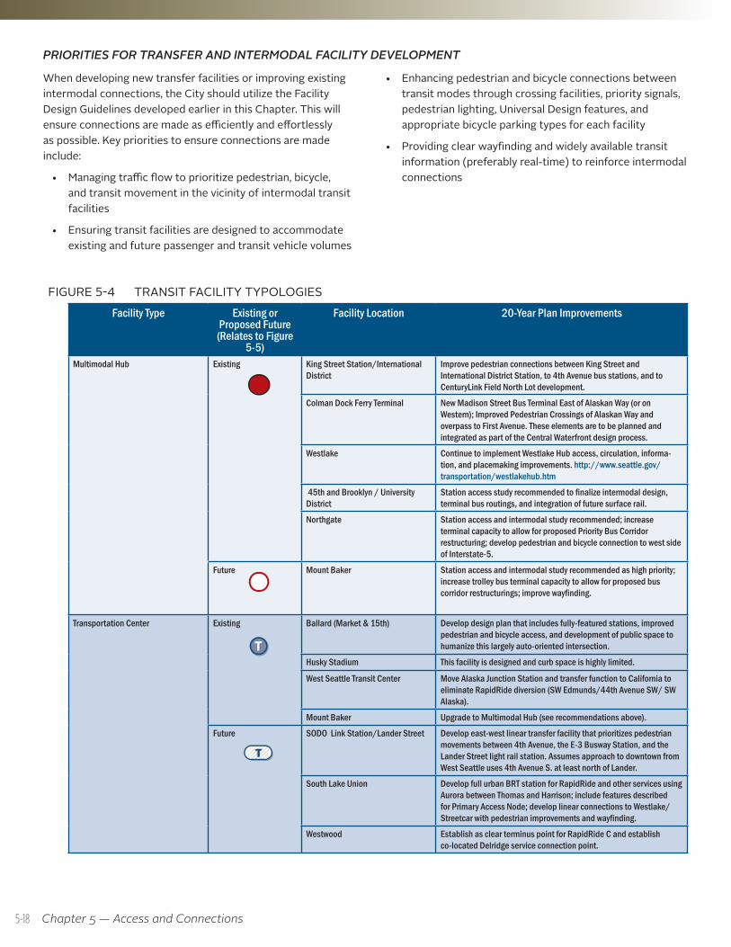
Multimodal Hub Existing King Street Station/International District
Improve pedestrian connections between King Street and International District Station, to 4th Avenue bus stations, and to CenturyLink Field North Lot development.
Colman Dock Ferry Terminal New Madison Street Bus Terminal East of Alaskan Way (or on Western); Improved Pedestrian Crossings of Alaskan Way and overpass to First Avenue. These elements are to be planned and integrated as part of the Central Waterfront design process.
Westlake Continue to implement Westlake Hub access, circulation, informa-tion, and placemaking improvements. http://www.seattle.gov/transportation/westlakehub.htm
45th and Brooklyn / University District
Station access study recommended to finalize intermodal design, terminal bus routings, and integration of future surface rail.
Northgate Station access and intermodal study recommended; increase terminal capacity to allow for proposed Priority Bus Corridor restructuring; develop pedestrian and bicycle connection to west side of Interstate-5.
Future Mount Baker Station access and intermodal study recommended as high priority; increase trolley bus terminal capacity to allow for proposed bus corridor restructurings; improve wayfinding.
Transportation Center Existing Ballard (Market & 15th) Develop design plan that includes fully-featured stations, improved pedestrian and bicycle access, and development of public space to humanize this largely auto-oriented intersection.
Husky Stadium This facility is designed and curb space is highly limited.
West Seattle Transit Center Move Alaska Junction Station and transfer function to California to eliminate RapidRide diversion (SW Edmunds/44th Avenue SW/ SW Alaska).
Mount Baker Upgrade to Multimodal Hub (see recommendations above).
Future SODO Link Station/Lander Street Develop east-west linear transfer facility that prioritizes pedestrian movements between 4th Avenue, the E-3 Busway Station, and the Lander Street light rail station. Assumes approach to downtown from West Seattle uses 4th Avenue S. at least north of Lander.
South Lake Union Develop full urban BRT station for RapidRide and other services using Aurora between Thomas and Harrison; include features described for Primary Access Node; develop linear connections to Westlake/Streetcar with pedestrian improvements and wayfinding.
Westwood Establish as clear terminus point for RapidRide C and establish co-located Delridge service connection point.
FIGURE 5-4 TRANSIT FACILITY TYPOLOGIES
TT
TTTTTT
5-18
Seattle Transit Master Plan
Facility Type Existing or Proposed Future
(Relates to Figure 5-5)
Facility Location 20-Year Plan Improvements
Light Rail Station Existing Rainier Beach, Othello, Columbia City, Mount Baker, Beacon Hill, SODO, Stadium, International District, Pioneer Square, University, Westlake
Comprehensive light rail station access and wayfinding program to improve visibility of rail station entrances, improve intermodal connections, and increase legibility of pedestrian and bicycle approaches to stations.
Promote redevelopment of undeveloped properties in station areas (public and private holdings) to improve pedestrian facilities, walking experience, and placemaking.
In the case of Rainier Beach, ensure adequate facilities and pedestrian accommodation for end-of-line operation for Rainier Avenue Corridor FTN service.
See other summary recommendations under Multimodal Hub or Transportation Center.
Future Capitol Hill, Husky Stadium, Brooklyn Roosevelt, Northgate, North Seattle (TBD); I-90
City should play an active role in facilitating intermodal design at Capitol Hill, University District, Roosevelt, and Northgate Stations.
Rapid Streetcar / BRT Station Future Multiple locations (see Figure 5-5) Develop to include: High capacity shelters at all stations, level boarding platforms, transit information for all routes serving area, real-time passenger information, off-board fare payment (where route appropriate), stop and area lighting, passenger/disabled waiting beacon (for late night boardings), seating, curb bulbs where appropriate, fully improved intersections including curb ramps, crossing markings, pedestrian signals (sufficient pedestrian crossing time), bicycle parking (covered if possible), pedestrian access improvements within ½-mile radius of station.
Center City Streetcar Station
Existing Consolidate stations on Westlake when Rapid Streetcar is con-structed (see Figure 5-5).
Future Multiple locations (see Figure 5-5) Develop to include: Shelters, level boarding platforms, transit information for all routes serving area, real-time passenger informa-tion, off-board fare payment (where route appropriate), seating, curb bulbs where appropriate, fully improved intersections including curb ramps, crossing markings, pedestrian signals (sufficient pedestrian crossing time), bicycle parking (covered if possible), pedestrian access improvements within ½-mile radius of stations.
Priority Access Node Future Aurora & 85th Street, Aurora and 105th, Greenwood and 105th Street, Greenwood and NW Market, 15th Ave NW and 85th Street; 15th Ave NW and Leary, 3rd Ave NW and Leary, 15th Ave NW and Dravus, 1st Ave/Queen Anne and Mercer, Aurora and Denny, Madison and Broadway, Madison and 12th, Madison and 23rd, Jefferson and 12th, Jefferson and 23rd, Jackson and 12th
Develop to include: High capacity shelters at all stations, standard-height curb boarding platforms, transit information for all routes serving area, real-time passenger information, off-board fare pay-ment (where route appropriate), stop and area lighting, passenger/disabled waiting beacon (for late night boardings), seating, curb bulbs where appropriate, fully improved intersections including curb ramps, crossing markings, pedestrian signals (sufficient pedestrian crossing time), bicycle parking (covered if possible).
Develop a plan and improvements for ½-mile radius pedestrian access and for intersecting and parallel bicycle facility improvements (pedestrian and bike improvements coordinated through master plans).
See Figure 5-3 for Sample Priority Access Node Design Features.
5-19
Chapter 5 — Access and Connections
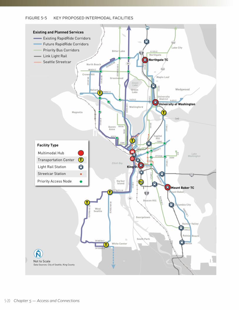
FIGURE 5-5 KEY PROPOSED INTERMODAL FACILITIES
Data Sources: City of Seattle, King CountyNot to Scale
UV99
UV520
UV522
UV522
UV99
RAINIER AVE S
RAINIER AVE S
BEACON AVE S
S JACKSON ST
YESLER
JEFFERSONCHERRY
PIKE
15TH
AVE W
SW BARTON ST
OTHELLO
HENDERSON
AURO
RA AV
E NAU
RORA
TA
YLOR
15TH
AVE
MERCER
DENNY
BOSTON
THOMAS
15TH
AVE N
W
1ST A
VE S
CALIF
ORNI
A AVE
SW
DELR
IDGE W
AY SW
24TH
AVE N
W
WEST SEATTLE BR
NW MARKET ST
N 45TH ST N 45TH ST
N 110TH ST
SW ROXBURY ST
23TH
AVE E
23TH
AVE E
34TH
HOLMAN RD NW
MADISON ST
GREE
NWOO
D AVE
N
NW 85TH ST
14TH
AVE S
FAIRV
IEW
10TH
AVE
5TH A
VE
ROOS
EVEL
T
LakeWashington
GreenLake
Elliott Bay
5
5
90
WestSeattle
Ballard
Magnolia
Lake City
Northgate
Beacon Hill
White Center
Bitter Lake
UniversityDistrict
GreenLake
QueenAnne
CapitolHill
Maple Leaf
South Park
Mount Baker
North Beach
Wallingford
Columbia City
Rainier Valley
Greenwood
Rainier Beach
Georgetown
Crown Hill
HarborIsland
Wedgwood
Priority Bus Corridors
Existing RapidRide Corridors
Link Light Rail
Future RapidRide Corridors
Existing and Planned Services
Seattle Streetcar
Multimodal Hub
Facility Type
Transportation Center
Light Rail Station
Streetcar Station
Priority Access Node
TT
TT
TT
TT
TT
TT
TT
TT
Mount Baker TC
Northgate TC
University of Washington
King St.
5-20
Seattle Transit Master Plan
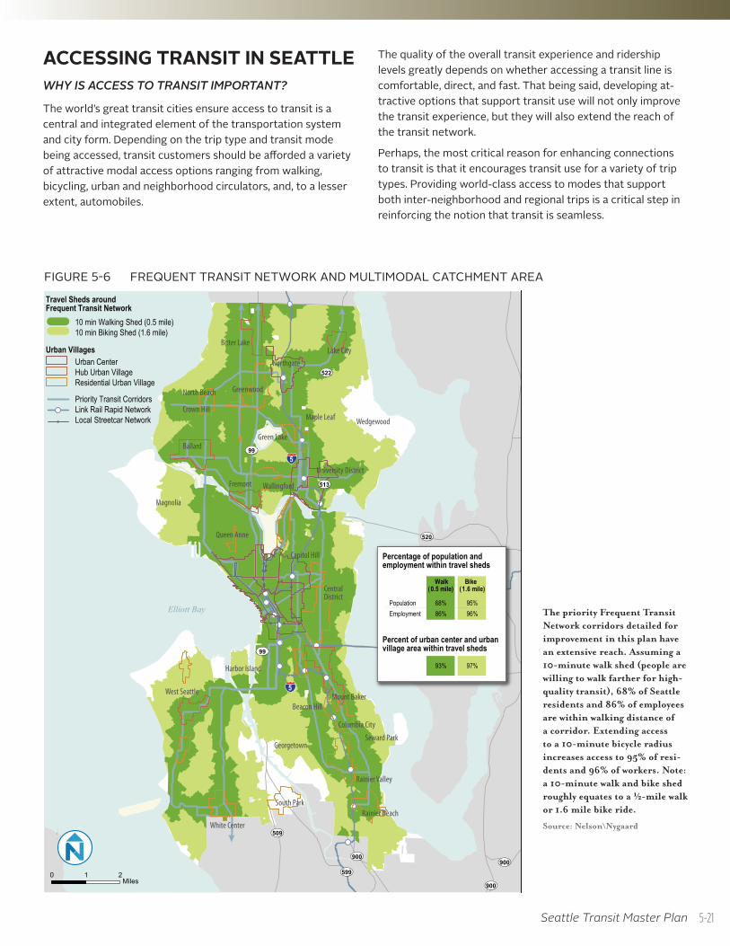
ACCESSING TRANSIT IN SEATTLE WHY IS ACCESS TO TRANSIT IMPORTANT?
The world’s great transit cities ensure access to transit is a central and integrated element of the transportation system and city form. Depending on the trip type and transit mode being accessed, transit customers should be afforded a variety of attractive modal access options ranging from walking, bicycling, urban and neighborhood circulators, and, to a lesser extent, automobiles.
The quality of the overall transit experience and ridership levels greatly depends on whether accessing a transit line is comfortable, direct, and fast. That being said, developing at-tractive options that support transit use will not only improve the transit experience, but they will also extend the reach of the transit network.
Perhaps, the most critical reason for enhancing connections to transit is that it encourages transit use for a variety of trip types. Providing world-class access to modes that support both inter-neighborhood and regional trips is a critical step in reinforcing the notion that transit is seamless.
!
!!
!!
!!
!!
!
!
! ! ! !!
!
!
!
!
!
West Seattle
Ballard
Magnolia
Lake City
Central District
Beacon Hill
Northgate
White Center
Bitter Lake
Green Lake
University District
Queen Anne
Wedgewood
Capitol Hill
Maple Leaf
South Park
North Beach
Mount Baker
Fremont Wallingford
Columbia City
Greenwood
Crown Hill
Seward Park
Rainier Valley
Rainier Beach
Harbor Island
Georgetown
UV99
UV520
UV522
UV509
UV513
UV599UV900UV900
UV900
UV99
5
LakeWashington
Elliott Bay
5
Priority Transit CorridorsLink Rail Rapid NetworkLocal Streetcar Network
10 min Walking Shed (0.5 mile)10 min Biking Shed (1.6 mile)
!
Percentage of population and employment within travel sheds
Walk Bike(0.5 mile) (1.6 mile)
Population 68% 95%Employment 86% 96%
93% 97%
Percent of urban center and urban village area within travel sheds
Travel Sheds around Frequent Transit Network
Urban VillagesUrban CenterHub Urban VillageResidential Urban Village
0 1 2Miles
FIGURE 5-6 FREQUENT TRANSIT NETWORK AND MULTIMODAL CATCHMENT AREA
The priority Frequent Transit Network corridors detailed for improvement in this plan have an extensive reach. Assuming a 10-minute walk shed (people are willing to walk farther for high-quality transit), 68% of Seattle residents and 86% of employees are within walking distance of a corridor. Extending access to a 10-minute bicycle radius increases access to 95% of resi-dents and 96% of workers. Note: a 10-minute walk and bike shed roughly equates to a ½-mile walk or 1.6 mile bike ride.
Source: Nelson\Nygaard
5-21
Chapter 5 — Access and Connections
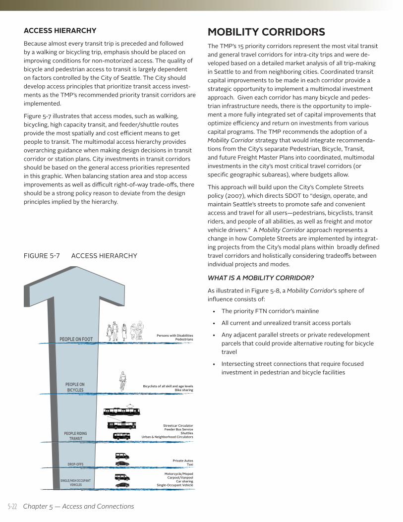
ACCESS HIERARCHYBecause almost every transit trip is preceded and followed by a walking or bicycling trip, emphasis should be placed on improving conditions for non-motorized access. The quality of bicycle and pedestrian access to transit is largely dependent on factors controlled by the City of Seattle. The City should develop access principles that prioritize transit access invest-ments as the TMP’s recommended priority transit corridors are implemented.
Figure 5-7 illustrates that access modes, such as walking, bicycling, high capacity transit, and feeder/shuttle routes provide the most spatially and cost efficient means to get people to transit. The multimodal access hierarchy provides overarching guidance when making design decisions in transit corridor or station plans. City investments in transit corridors should be based on the general access priorities represented in this graphic. When balancing station area and stop access improvements as well as difficult right-of-way trade-offs, there should be a strong policy reason to deviate from the design principles implied by the hierarchy.
FIGURE 5-7 ACCESS HIERARCHY
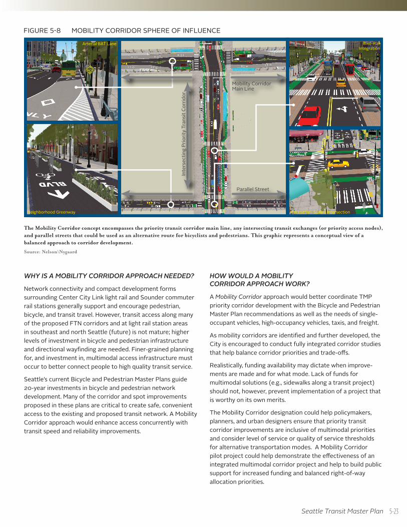
MOBILITY CORRIDORSThe TMP’s 15 priority corridors represent the most vital transit and general travel corridors for intra-city trips and were de-veloped based on a detailed market analysis of all trip-making in Seattle to and from neighboring cities. Coordinated transit capital improvements to be made in each corridor provide a strategic opportunity to implement a multimodal investment approach. Given each corridor has many bicycle and pedes-trian infrastructure needs, there is the opportunity to imple-ment a more fully integrated set of capital improvements that optimize efficiency and return on investments from various capital programs. The TMP recommends the adoption of a Mobility Corridor strategy that would integrate recommenda-tions from the City’s separate Pedestrian, Bicycle, Transit, and future Freight Master Plans into coordinated, multimodal investments in the city’s most critical travel corridors (or specific geographic subareas), where budgets allow.
This approach will build upon the City’s Complete Streets policy (2007), which directs SDOT to “design, operate, and maintain Seattle’s streets to promote safe and convenient access and travel for all users—pedestrians, bicyclists, transit riders, and people of all abilities, as well as freight and motor vehicle drivers.” A Mobility Corridor approach represents a change in how Complete Streets are implemented by integrat-ing projects from the City’s modal plans within broadly defined travel corridors and holistically considering tradeoffs between individual projects and modes.
WHAT IS A MOBILITY CORRIDOR?
As illustrated in Figure 5-8, a Mobility Corridor’s sphere of influence consists of:
• The priority FTN corridor’s mainline
• All current and unrealized transit access portals
• Any adjacent parallel streets or private redevelopment parcels that could provide alternative routing for bicycle travel
• Intersecting street connections that require focused investment in pedestrian and bicycle facilities
Persons with DisabilitiesPedestrians
Bicyclists of all skill and age levelsBike sharing
Streetcar CirculatorFeeder Bus Service
ShuttlesUrban & Neighborhood Circulators
Private AutosTaxi
Motorcycle/MopedCarpool/Vanpool
Car sharingSingle-Occupant Vehicle
Taxi
5-22
Seattle Transit Master Plan
FIGURE 5-8 MOBILITY CORRIDOR SPHERE OF INFLUENCE
Mobility Corridor Main Line
Parallel StreetIn
ters
ectin
g Pr
iorit
y Tr
ansi
t Cor
ridor
Arterial BAT Lane
Neighborhood Greenway
Bike-Rail Integration
Pedestrian-Scaled Intersection
The Mobility Corridor concept encompasses the priority transit corridor main line, any intersecting transit exchanges (or priority access nodes), and parallel streets that could be used as an alternative route for bicyclists and pedestrians. This graphic represents a conceptual view of a balanced approach to corridor development.
Source: Nelson\Nygaard
WHY IS A MOBILITY CORRIDOR APPROACH NEEDED?
Network connectivity and compact development forms surrounding Center City Link light rail and Sounder commuter rail stations generally support and encourage pedestrian, bicycle, and transit travel. However, transit access along many of the proposed FTN corridors and at light rail station areas in southeast and north Seattle (future) is not mature; higher levels of investment in bicycle and pedestrian infrastructure and directional wayfinding are needed. Finer-grained planning for, and investment in, multimodal access infrastructure must occur to better connect people to high quality transit service.
Seattle’s current Bicycle and Pedestrian Master Plans guide 20-year investments in bicycle and pedestrian network development. Many of the corridor and spot improvements proposed in these plans are critical to create safe, convenient access to the existing and proposed transit network. A Mobility Corridor approach would enhance access concurrently with transit speed and reliability improvements.
HOW WOULD A MOBILITY CORRIDOR APPROACH WORK?
A Mobility Corridor approach would better coordinate TMP priority corridor development with the Bicycle and Pedestrian Master Plan recommendations as well as the needs of single-occupant vehicles, high-occupancy vehicles, taxis, and freight.
As mobility corridors are identified and further developed, the City is encouraged to conduct fully integrated corridor studies that help balance corridor priorities and trade-offs.
Realistically, funding availability may dictate when improve-ments are made and for what mode. Lack of funds for multimodal solutions (e.g., sidewalks along a transit project) should not, however, prevent implementation of a project that is worthy on its own merits.
The Mobility Corridor designation could help policymakers, planners, and urban designers ensure that priority transit corridor improvements are inclusive of multimodal priorities and consider level of service or quality of service thresholds for alternative transportation modes. A Mobility Corridor pilot project could help demonstrate the effectiveness of an integrated multimodal corridor project and help to build public support for increased funding and balanced right-of-way allocation priorities.
5-23
Chapter 5 — Access and Connections
WHAT ARE THE LIKELY BENEFITS AND OUTCOMES?
The City could expect the following benefits and outcomes should a holistic Mobility Corridor approach be fully developed and adopted:
• Clearly establish urban centers and urban villages on the FTN as vital, convenient, and sustainable places to live in Seattle
• Improve the transportation efficiency and throughput of both people and goods, while also improving priority transit corridor access
• Present an opportunity to be substantially more effec-tive in shifting SOV mode share than with a transit-only project
Coordinated planning, joint design, and construction of pedestrian, bicycle, and transit projects will:
• Reduce construction disruptions and costs (one project vs. multiple)
• Create efficiencies in planning, design, and implementation
• Reduce future design complexities of integrating other modal improvements
• Allow for more effective resolution of difficult right-of-way tradeoffs and the inclusion of parallel roadways/routes for consideration in creating key active transporta-tion connections
To realize these benefits, the City should develop a coor-dinated investment plan that synchronizes recommended investments from the four modal plans (transit, pedestrian, bicycle, and freight). Annual review of five-year updates to other modal plans should consider the Mobility Corridor investment framework.
5-24
Seattle Transit Master Plan
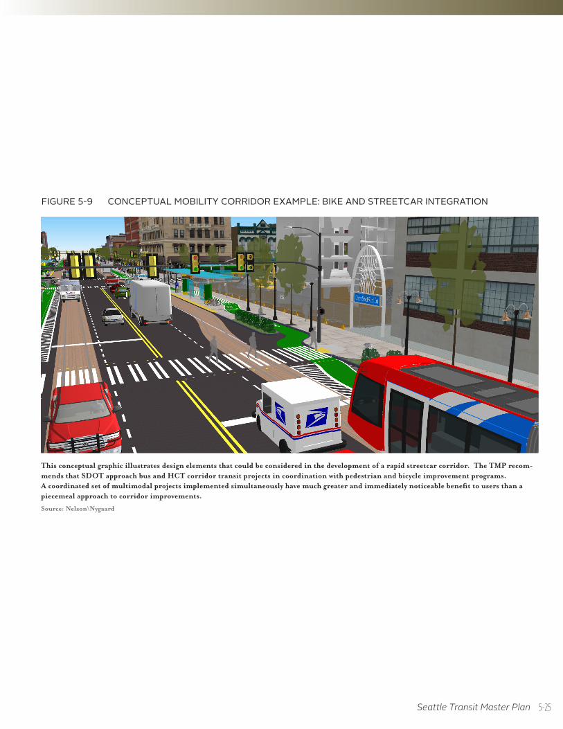
FIGURE 5-9 CONCEPTUAL MOBILITY CORRIDOR EXAMPLE: BIKE AND STREETCAR INTEGRATION
This conceptual graphic illustrates design elements that could be considered in the development of a rapid streetcar corridor. The TMP recom-mends that SDOT approach bus and HCT corridor transit projects in coordination with pedestrian and bicycle improvement programs. A coordinated set of multimodal projects implemented simultaneously have much greater and immediately noticeable benefit to users than a piecemeal approach to corridor improvements.
Source: Nelson\Nygaard
5-25
Chapter 5 — Access and Connections
MOBILITY CORRIDOR DESIGN AND PERFORMANCE
MODAL INTEGRATION
• Policy MC1.1: Development of Mobility Corridors should integrate principles of context sensitive Complete Street design that are unique to conditions found in each corridor.
• Policy MC1.2: Transit vehicles should be given priority (in design and operation) over other modes of personal motor vehicle traffic in primary transit corridors and in any corridor where FTN service levels are provided.
• Policy MC1.3: Mobility should be measured in terms of “aggregate person delay” rather than vehicular level of service, which does not distinguish between single-occupant vehicles, a full bus, and a wave of cyclists.
• Policy MC1.4: Mobility Corridor carrying capacity should be measured in terms of person throughput rather than vehicle throughput.
• Policy MC1.5: Locating layover facilities on intersecting streets should be prioritized in Mobility Corridors with limited right-of-way. The City should consider incentives to accommodate capacity for transit layovers in new development where appropriate.
TRANSIT
• Policy MC2.1: Ensure transit priority lane treatments take precedence over general purpose travel lanes and auto storage on priority transit corridors.
• Policy MC2.2: Implement Transit Signal Priority (TSP) along transit corridors to provide transit vehicles with precedence at signalized intersections, while considering cross-street pedestrian and traffic demand.
• Policy MC2.3: Design linear transit facilities that minimize conflicts and pinch points with other roadway users and facilitate in-lane stops.
• Policy MC2.4: Corridors with limited right-of-way should not accommodate layover zones along the linear transit facilities.
PEDESTRIAN
• Policy MC3.1: Pedestrians should be afforded the highest priority in corridor space allocation to maintain an attrac-tive public realm that connects to transit facilities.
Mobility Corridor design should reflect the fact that even if a transit facility is located within a reasonable walking distance of a person’s origin and destination, the walking environment will influence their choice to use transit.
• Policy MC3.2: Expand the pedestrian realm and use public space projects to increase pedestrian and waiting passenger capacity at stops and stations.
CYCLISTS
• Policy MC4.1: Provide high-quality bike facilities along parallel priority transit corridors and on strategic streets that link into the Mobility Corridor.
• Policy MC4.2: If the right-of-way is too constrained to provide a bike facility along the transit mainline, consider developing high-quality bike facilities, like neighborhood greenways, along parallel streets. Facility selection/design should consider whether alternative routes allow cyclists to conveniently and directly access services and destina-tions located on the mainline street.
• Policy MC4.3: Bike-share stations (or the capacity to develop them) should be integrated into the design of transit stops and stations in areas targeted for bike-share implementation. If sidewalk capacity is constrained, consider parking removal to accommodate a bike-share station on the street.
AUTOS, FREIGHT, TAXI
• Policy MC5.1: Repurpose on-street parking spaces, where necessary, for expanded sidewalks and pedestrian spaces, bicycle facilities and on-street bicycle parking corrals, and dedicated transit lanes.
• Policy MC5.2: Any decisions to remove on-street parking supply for use by transit should consider the net change in local business access, measured in terms of person capacity and change in pedestrian volumes, and role of on-street parking in calming traffic and buffering pedes-trians from traffic.
• Policy MC5.3: Where a limited pedestrian buffer exists, consider using recessed on-street parking as a pedestrian buffer between the sidewalk and moving traffic.
• Policy MC5.4: Space-constrained corridors designated as Major Truck Streets should allow freight to use transit lanes.
• Policy MC5.5: To the extent that they would not interfere with transit reliability and travel time, taxis should be allowed access to transit lanes (except on Major Truck Streets).
• Policy MC5.6: In neighborhood commercial corridors with transit-only curb lanes and no on-street parking, it might be necessary to provide “cutout” loading bays and allow delivery vehicles to merge into transit lanes in order to access the loading bays. Provision of taxi parking bays should also be considered near major destinations, transportation centers, and multimodal hubs.
5-26
Seattle Transit Master Plan
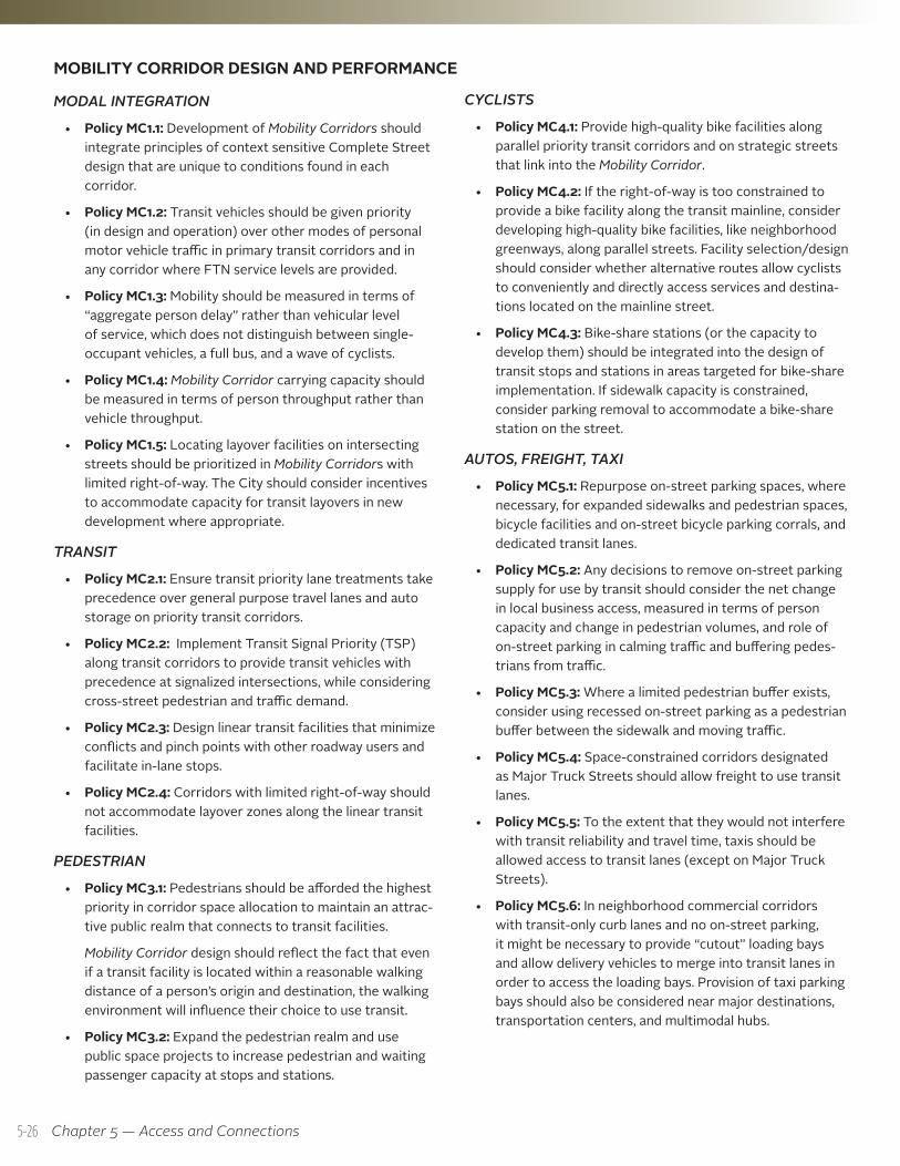
Enhanced bicycle access along parallel street
Main transit corridor prioritizes space for transit treatments
FIGURE 5-10 CONCEPTUAL BRT CORRIDOR TRADEOFFS
Constrained priority transit corridors, such as this conceptual BRT corridor, require difficult decisions given trade-offs related to pedestrian space, bike facility development, preserving general purpose travel lanes, and parking supply.
Source: Nelson\Nygaard
5-27
Chapter 5 — Access and Connections
STATION AND STOP LOCATION TYPESSeattle’s network of transit stops, stations, and major intermodal transfer facilities (which are described on pages 5-16 to 5-19 earlier in this chapter) is characterized within a station/stop location typology that represents where these transit facilities are typically located. Representative station and stop location types are illustrated on this page and page 5-29. Figure 5-11 provides a matrix that indicates each location’s function and provides guidance for the types of access features and amenities that should be provided.
These location types describe street classifications where station and stop types are typically located, nodes where several prior-ity transit corridors intersect, and/or nodes where local and regional intermodal connections can be made (including Multimodal Hubs, Transportation Centers, and a variety of high capacity transit stations). Urban transit stops should, under most circum-stances, have an in-lane configuration to reduce delay for transit vehicles and passengers.
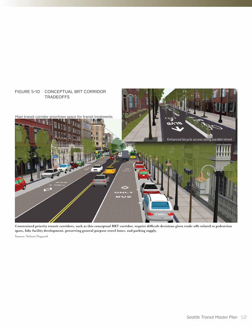
RESIDENTIAL STREET
Residential streets are loci of basic local bus service stops. Increased investment in stops along residential streets should be based on boarding activity. 32nd Avenue NW is an example of a residential street that carries transit service.
Image from Nelson\Nygaard
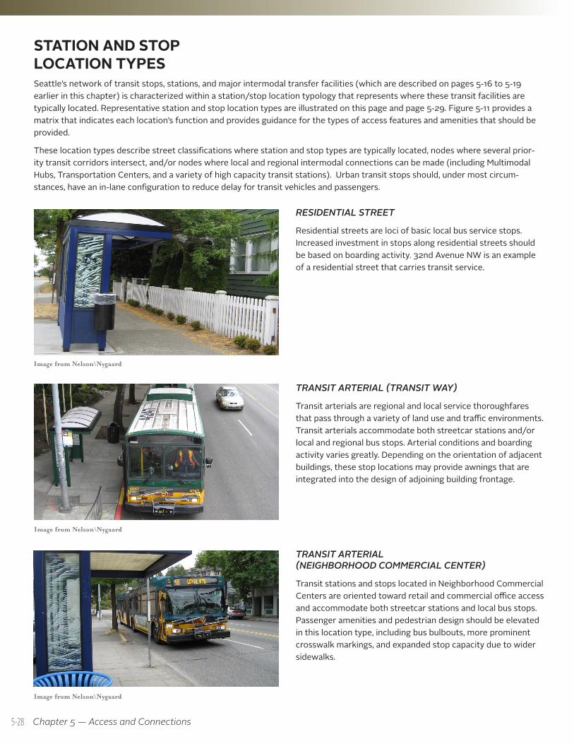
TRANSIT ARTERIAL (TRANSIT WAY)
Transit arterials are regional and local service thoroughfares that pass through a variety of land use and traffic environments. Transit arterials accommodate both streetcar stations and/or local and regional bus stops. Arterial conditions and boarding activity varies greatly. Depending on the orientation of adjacent buildings, these stop locations may provide awnings that are integrated into the design of adjoining building frontage.
TRANSIT ARTERIAL (NEIGHBORHOOD COMMERCIAL CENTER)
Transit stations and stops located in Neighborhood Commercial Centers are oriented toward retail and commercial office access and accommodate both streetcar stations and local bus stops. Passenger amenities and pedestrian design should be elevated in this location type, including bus bulbouts, more prominent crosswalk markings, and expanded stop capacity due to wider sidewalks.
Image from Nelson\Nygaard
Image from Nelson\Nygaard
5-28
Seattle Transit Master Plan
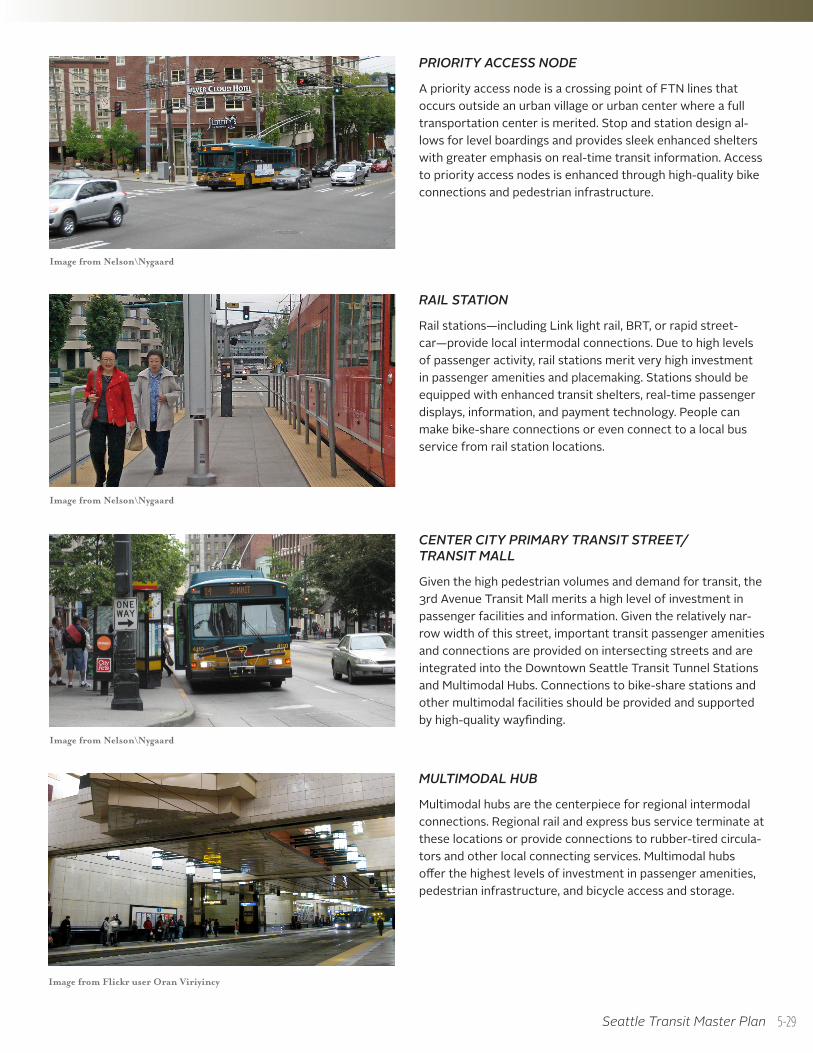
PRIORITY ACCESS NODE
A priority access node is a crossing point of FTN lines that occurs outside an urban village or urban center where a full transportation center is merited. Stop and station design al-lows for level boardings and provides sleek enhanced shelters with greater emphasis on real-time transit information. Access to priority access nodes is enhanced through high-quality bike connections and pedestrian infrastructure.
Image from Nelson\Nygaard
CENTER CITY PRIMARY TRANSIT STREET/ TRANSIT MALL
Given the high pedestrian volumes and demand for transit, the 3rd Avenue Transit Mall merits a high level of investment in passenger facilities and information. Given the relatively nar-row width of this street, important transit passenger amenities and connections are provided on intersecting streets and are integrated into the Downtown Seattle Transit Tunnel Stations and Multimodal Hubs. Connections to bike-share stations and other multimodal facilities should be provided and supported by high-quality wayfinding.
RAIL STATION
Rail stations—including Link light rail, BRT, or rapid street-car—provide local intermodal connections. Due to high levels of passenger activity, rail stations merit very high investment in passenger amenities and placemaking. Stations should be equipped with enhanced transit shelters, real-time passenger displays, information, and payment technology. People can make bike-share connections or even connect to a local bus service from rail station locations.
Image from Nelson\Nygaard
Image from Nelson\Nygaard
MULTIMODAL HUB
Multimodal hubs are the centerpiece for regional intermodal connections. Regional rail and express bus service terminate at these locations or provide connections to rubber-tired circula-tors and other local connecting services. Multimodal hubs offer the highest levels of investment in passenger amenities, pedestrian infrastructure, and bicycle access and storage.
Image from Flickr user Oran Viriyincy
5-29
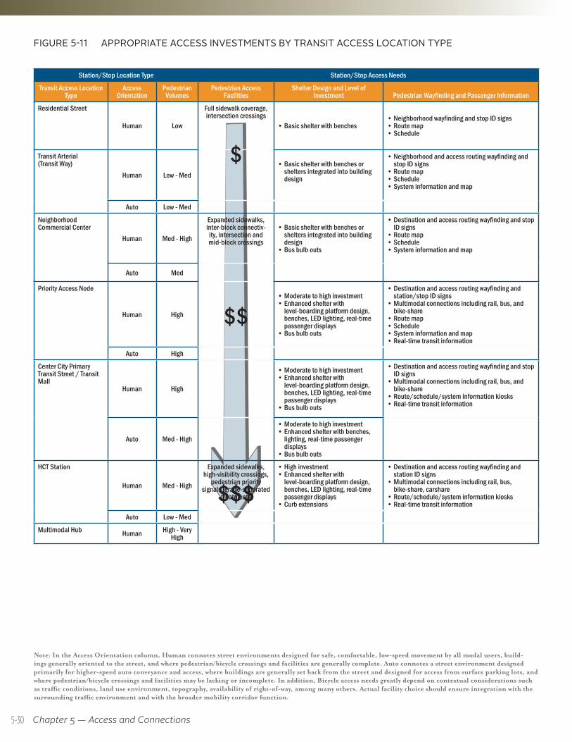
Chapter 5 — Access and Connections
FIGURE 5-11 APPROPRIATE ACCESS INVESTMENTS BY TRANSIT ACCESS LOCATION TYPE
Note: In the Access Orientation column, Human connotes street environments designed for safe, comfortable, low-speed movement by all modal users, build-ings generally oriented to the street, and where pedestrian/bicycle crossings and facilities are generally complete. Auto connotes a street environment designed primarily for higher-speed auto conveyance and access, where buildings are generally set back from the street and designed for access from surface parking lots, and where pedestrian/bicycle crossings and facilities may be lacking or incomplete. In addition, Bicycle access needs greatly depend on contextual considerations such as traffic conditions, land use environment, topography, availability of right-of-way, among many others. Actual facility choice should ensure integration with the surrounding traffic environment and with the broader mobility corridor function.
Station/Stop Location Type Station/Stop Access Needs
Transit Access Location Type
Access Orientation
Pedestrian Volumes
Pedestrian Access Facilities
Shelter Design and Level of Investment Pedestrian Wayfinding and Passenger Information
Residential Street
Human Low
Full sidewalk coverage, intersection crossings
• Basic shelter with benches• Neighborhood wayfinding and stop ID signs• Route map• Schedule
Transit Arterial (Transit Way)
Human Low - Med• Basic shelter with benches or
shelters integrated into building design
• Neighborhood and access routing wayfinding and stop ID signs
• Route map• Schedule• System information and map
Auto Low - Med
Neighborhood Commercial Center
Human Med - High
Expanded sidewalks, inter-block connectiv-ity, intersection and mid-block crossings
• Basic shelter with benches or shelters integrated into building design
• Bus bulb outs
• Destination and access routing wayfinding and stop ID signs
• Route map• Schedule• System information and map
Auto Med
Priority Access Node
Human High
• Moderate to high investment• Enhanced shelter with
level-boarding platform design, benches, LED lighting, real-time passenger displays
• Bus bulb outs
• Destination and access routing wayfinding and station/stop ID signs
• Multimodal connections including rail, bus, and bike-share
• Route map• Schedule• System information and map• Real-time transit information
Auto High
Center City Primary Transit Street / Transit Mall
Human High
• Moderate to high investment• Enhanced shelter with
level-boarding platform design, benches, LED lighting, real-time passenger displays
• Bus bulb outs
• Destination and access routing wayfinding and stop ID signs
• Multimodal connections including rail, bus, and bike-share
• Route/schedule/system information kiosks• Real-time transit information
Auto Med - High
• Moderate to high investment• Enhanced shelter with benches,
lighting, real-time passenger displays
• Bus bulb outs
HCT Station
Human Med - High
Expanded sidewalks, high-visibility crossings,
pedestrian priority signals, grade-separated
treatments
• High investment• Enhanced shelter with
level-boarding platform design, benches, LED lighting, real-time passenger displays
• Curb extensions
• Destination and access routing wayfinding and station ID signs
• Multimodal connections including rail, bus, bike-share, carshare
• Route/schedule/system information kiosks• Real-time transit information
Auto Low - Med
Multimodal Hub Human High - Very High
Station/Stop Access Needs
$$
$$$
$
5-30
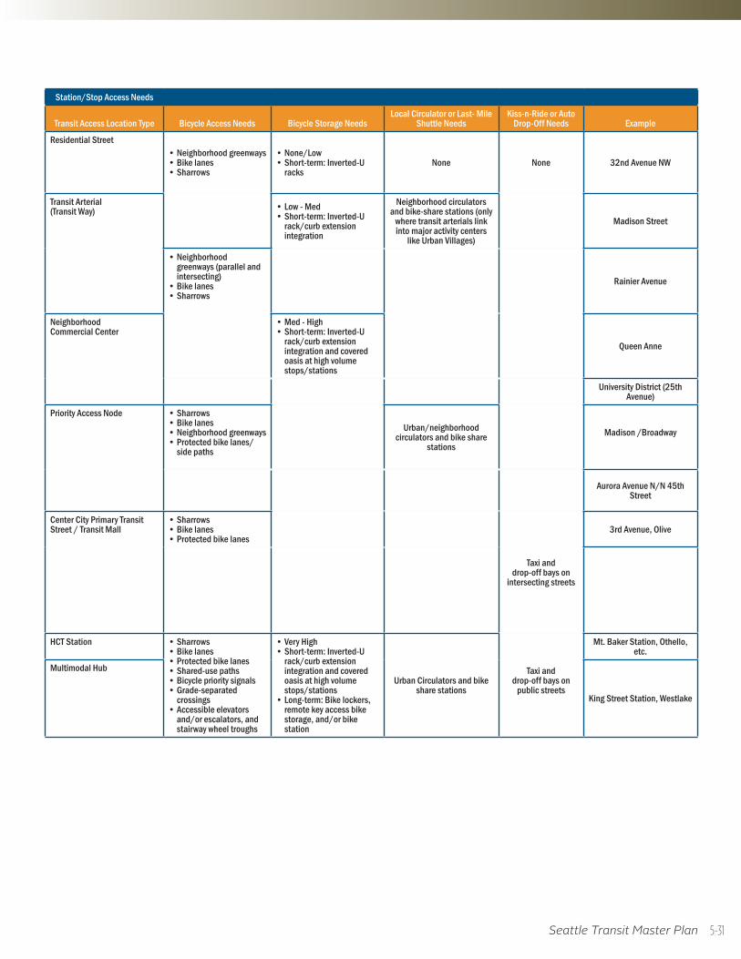
Seattle Transit Master Plan
Station/Stop Access Needs
Transit Access Location Type Bicycle Access Needs Bicycle Storage NeedsLocal Circulator or Last- Mile
Shuttle NeedsKiss-n-Ride or Auto
Drop-Off Needs Example
Residential Street • Neighborhood greenways• Bike lanes• Sharrows
• None/Low• Short-term: Inverted-U
racksNone None 32nd Avenue NW
Transit Arterial (Transit Way) • Low - Med
• Short-term: Inverted-U rack/curb extension integration
Neighborhood circulators and bike-share stations (only
where transit arterials link into major activity centers
like Urban Villages)
Madison Street
• Neighborhood greenways (parallel and intersecting)
• Bike lanes • Sharrows
Rainier Avenue
Neighborhood Commercial Center
• Med - High• Short-term: Inverted-U
rack/curb extension integration and covered oasis at high volume stops/stations
Queen Anne
University District (25th Avenue)
Priority Access Node • Sharrows• Bike lanes • Neighborhood greenways• Protected bike lanes/
side paths
Urban/neighborhood circulators and bike share
stationsMadison /Broadway
Aurora Avenue N/N 45th Street
Center City Primary Transit Street / Transit Mall
• Sharrows• Bike lanes • Protected bike lanes
Taxi and drop-off bays on
intersecting streets
3rd Avenue, Olive
HCT Station • Sharrows• Bike lanes • Protected bike lanes• Shared-use paths• Bicycle priority signals• Grade-separated
crossings• Accessible elevators
and/or escalators, and stairway wheel troughs
• Very High• Short-term: Inverted-U
rack/curb extension integration and covered oasis at high volume stops/stations
• Long-term: Bike lockers, remote key access bike storage, and/or bike station
Urban Circulators and bike share stations
Taxi and drop-off bays on
public streets
Mt. Baker Station, Othello, etc.
Multimodal Hub
King Street Station, Westlake
5-31
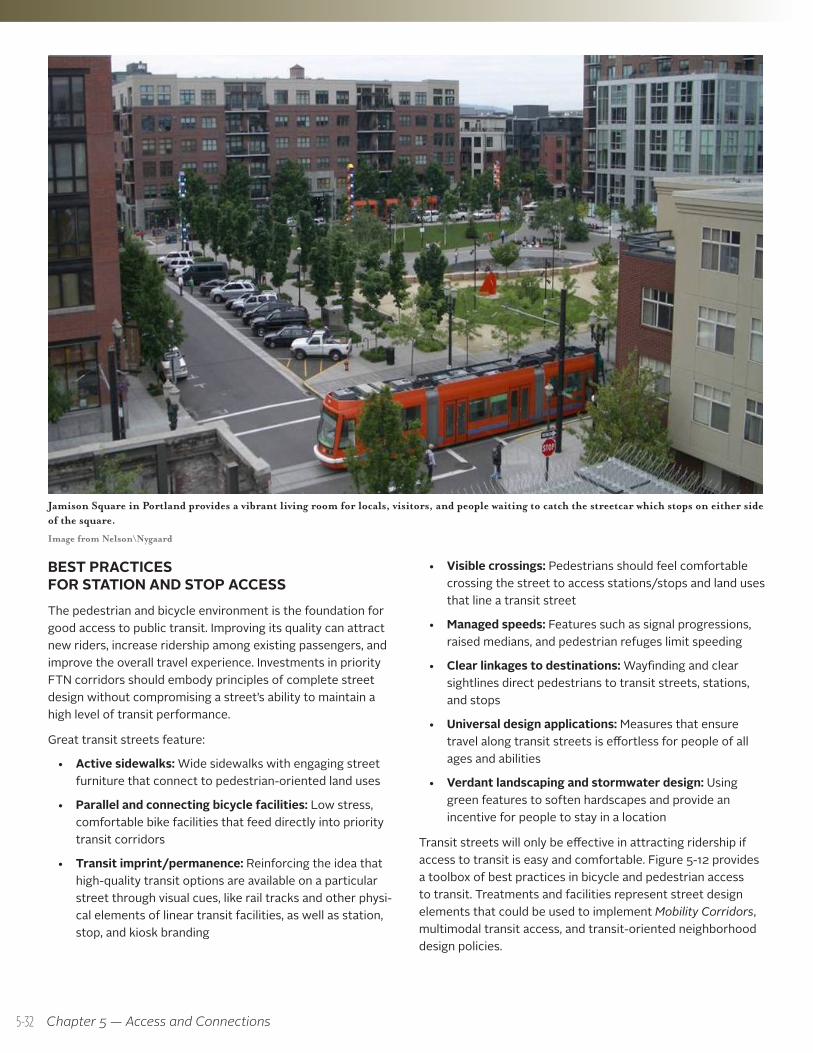
Chapter 5 — Access and Connections
BEST PRACTICES FOR STATION AND STOP ACCESSThe pedestrian and bicycle environment is the foundation for good access to public transit. Improving its quality can attract new riders, increase ridership among existing passengers, and improve the overall travel experience. Investments in priority FTN corridors should embody principles of complete street design without compromising a street’s ability to maintain a high level of transit performance.
Great transit streets feature:
• Active sidewalks: Wide sidewalks with engaging street furniture that connect to pedestrian-oriented land uses
• Parallel and connecting bicycle facilities: Low stress, comfortable bike facilities that feed directly into priority transit corridors
• Transit imprint/permanence: Reinforcing the idea that high-quality transit options are available on a particular street through visual cues, like rail tracks and other physi-cal elements of linear transit facilities, as well as station, stop, and kiosk branding
• Visible crossings: Pedestrians should feel comfortable crossing the street to access stations/stops and land uses that line a transit street
• Managed speeds: Features such as signal progressions, raised medians, and pedestrian refuges limit speeding
• Clear linkages to destinations: Wayfinding and clear sightlines direct pedestrians to transit streets, stations, and stops
• Universal design applications: Measures that ensure travel along transit streets is effortless for people of all ages and abilities
• Verdant landscaping and stormwater design: Using green features to soften hardscapes and provide an incentive for people to stay in a location
Transit streets will only be effective in attracting ridership if access to transit is easy and comfortable. Figure 5-12 provides a toolbox of best practices in bicycle and pedestrian access to transit. Treatments and facilities represent street design elements that could be used to implement Mobility Corridors, multimodal transit access, and transit-oriented neighborhood design policies.
Jamison Square in Portland provides a vibrant living room for locals, visitors, and people waiting to catch the streetcar which stops on either side of the square.
Image from Nelson\Nygaard
5-32
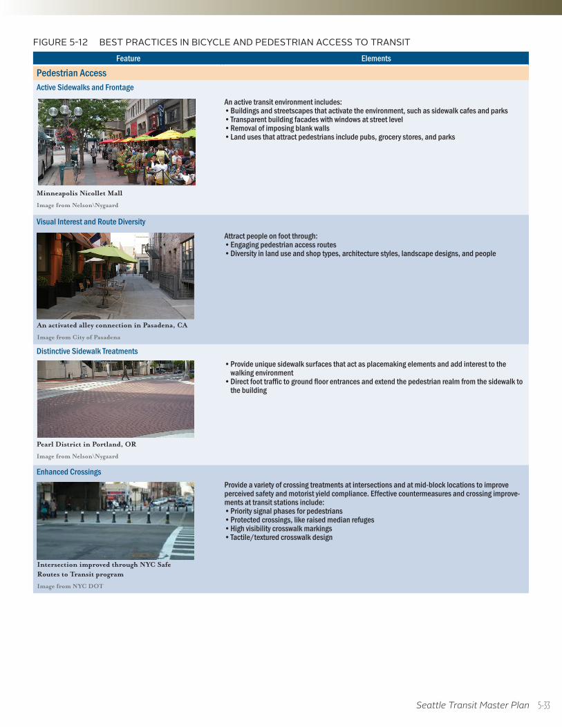
Seattle Transit Master Plan
Feature Elements
Pedestrian AccessActive Sidewalks and Frontage
Minneapolis Nicollet Mall
Image from Nelson\Nygaard
An active transit environment includes:• Buildings and streetscapes that activate the environment, such as sidewalk cafes and parks• Transparent building facades with windows at street level• Removal of imposing blank walls• Land uses that attract pedestrians include pubs, grocery stores, and parks
Visual Interest and Route Diversity
An activated alley connection in Pasadena, CA
Image from City of Pasadena
Attract people on foot through: • Engaging pedestrian access routes• Diversity in land use and shop types, architecture styles, landscape designs, and people
Distinctive Sidewalk Treatments
Pearl District in Portland, OR
Image from Nelson\Nygaard
• Provide unique sidewalk surfaces that act as placemaking elements and add interest to the walking environment
• Direct foot traffic to ground floor entrances and extend the pedestrian realm from the sidewalk to the building
Enhanced Crossings
Intersection improved through NYC Safe Routes to Transit program
Image from NYC DOT
Provide a variety of crossing treatments at intersections and at mid-block locations to improve perceived safety and motorist yield compliance. Effective countermeasures and crossing improve-ments at transit stations include:• Priority signal phases for pedestrians• Protected crossings, like raised median refuges• High visibility crosswalk markings • Tactile/textured crosswalk design
FIGURE 5-12 BEST PRACTICES IN BICYCLE AND PEDESTRIAN ACCESS TO TRANSIT
5-33
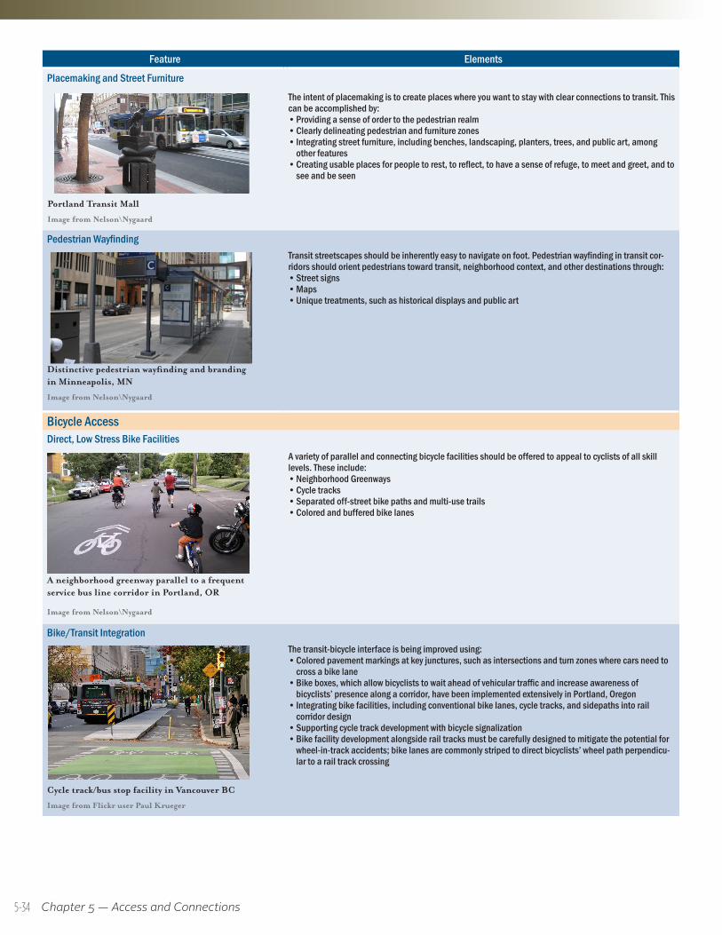
Chapter 5 — Access and Connections
Feature Elements
Placemaking and Street Furniture
Portland Transit Mall
Image from Nelson\Nygaard
The intent of placemaking is to create places where you want to stay with clear connections to transit. This can be accomplished by:• Providing a sense of order to the pedestrian realm• Clearly delineating pedestrian and furniture zones• Integrating street furniture, including benches, landscaping, planters, trees, and public art, among
other features• Creating usable places for people to rest, to reflect, to have a sense of refuge, to meet and greet, and to
see and be seen
Pedestrian Wayfinding
Distinctive pedestrian wayfinding and branding in Minneapolis, MN
Image from Nelson\Nygaard
Transit streetscapes should be inherently easy to navigate on foot. Pedestrian wayfinding in transit cor-ridors should orient pedestrians toward transit, neighborhood context, and other destinations through:• Street signs • Maps• Unique treatments, such as historical displays and public art
Bicycle AccessDirect, Low Stress Bike Facilities
A neighborhood greenway parallel to a frequent service bus line corridor in Portland, OR
Image from Nelson\Nygaard
A variety of parallel and connecting bicycle facilities should be offered to appeal to cyclists of all skill levels. These include: • Neighborhood Greenways• Cycle tracks• Separated off-street bike paths and multi-use trails• Colored and buffered bike lanes
Bike/Transit Integration
Cycle track/bus stop facility in Vancouver BC
Image from Flickr user Paul Krueger
The transit-bicycle interface is being improved using:• Colored pavement markings at key junctures, such as intersections and turn zones where cars need to
cross a bike lane• Bike boxes, which allow bicyclists to wait ahead of vehicular traffic and increase awareness of
bicyclists’ presence along a corridor, have been implemented extensively in Portland, Oregon• Integrating bike facilities, including conventional bike lanes, cycle tracks, and sidepaths into rail
corridor design• Supporting cycle track development with bicycle signalization• Bike facility development alongside rail tracks must be carefully designed to mitigate the potential for
wheel-in-track accidents; bike lanes are commonly striped to direct bicyclists’ wheel path perpendicu-lar to a rail track crossing
5-34
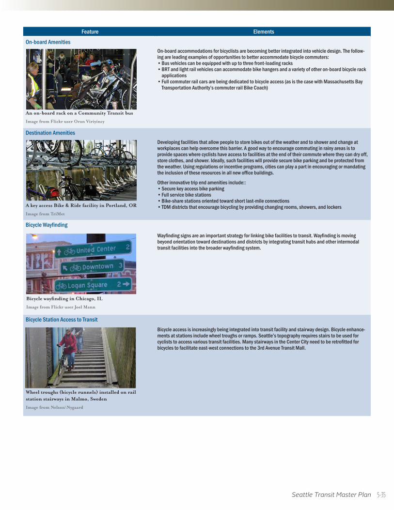
Seattle Transit Master Plan
Feature Elements
Placemaking and Street Furniture
Portland Transit Mall
Image from Nelson\Nygaard
The intent of placemaking is to create places where you want to stay with clear connections to transit. This can be accomplished by:• Providing a sense of order to the pedestrian realm• Clearly delineating pedestrian and furniture zones• Integrating street furniture, including benches, landscaping, planters, trees, and public art, among
other features• Creating usable places for people to rest, to reflect, to have a sense of refuge, to meet and greet, and to
see and be seen
Pedestrian Wayfinding
Distinctive pedestrian wayfinding and branding in Minneapolis, MN
Image from Nelson\Nygaard
Transit streetscapes should be inherently easy to navigate on foot. Pedestrian wayfinding in transit cor-ridors should orient pedestrians toward transit, neighborhood context, and other destinations through:• Street signs • Maps• Unique treatments, such as historical displays and public art
Bicycle AccessDirect, Low Stress Bike Facilities
A neighborhood greenway parallel to a frequent service bus line corridor in Portland, OR
Image from Nelson\Nygaard
A variety of parallel and connecting bicycle facilities should be offered to appeal to cyclists of all skill levels. These include: • Neighborhood Greenways• Cycle tracks• Separated off-street bike paths and multi-use trails• Colored and buffered bike lanes
Bike/Transit Integration
Cycle track/bus stop facility in Vancouver BC
Image from Flickr user Paul Krueger
The transit-bicycle interface is being improved using:• Colored pavement markings at key junctures, such as intersections and turn zones where cars need to
cross a bike lane• Bike boxes, which allow bicyclists to wait ahead of vehicular traffic and increase awareness of
bicyclists’ presence along a corridor, have been implemented extensively in Portland, Oregon• Integrating bike facilities, including conventional bike lanes, cycle tracks, and sidepaths into rail
corridor design• Supporting cycle track development with bicycle signalization• Bike facility development alongside rail tracks must be carefully designed to mitigate the potential for
wheel-in-track accidents; bike lanes are commonly striped to direct bicyclists’ wheel path perpendicu-lar to a rail track crossing
Feature Elements
On-board Amenities
An on-board rack on a Community Transit bus
Image from Flickr user Oran Viriyincy
On-board accommodations for bicyclists are becoming better integrated into vehicle design. The follow-ing are leading examples of opportunities to better accommodate bicycle commuters: • Bus vehicles can be equipped with up to three front-loading racks• BRT and light rail vehicles can accommodate bike hangers and a variety of other on-board bicycle rack
applications• Full commuter rail cars are being dedicated to bicycle access (as is the case with Massachusetts Bay
Transportation Authority’s commuter rail Bike Coach)
Destination Amenities
A key access Bike & Ride facility in Portland, OR
Image from TriMet
Developing facilities that allow people to store bikes out of the weather and to shower and change at workplaces can help overcome this barrier. A good way to encourage commuting in rainy areas is to provide spaces where cyclists have access to facilities at the end of their commute where they can dry off, store clothes, and shower. Ideally, such facilities will provide secure bike parking and be protected from the weather. Using regulations or incentive programs, cities can play a part in encouraging or mandating the inclusion of these resources in all new office buildings.
Other innovative trip end amenities include::• Secure key access bike parking• Full service bike stations• Bike-share stations oriented toward short last-mile connections• TDM districts that encourage bicycling by providing changing rooms, showers, and lockers
Bicycle Wayfinding
Bicycle wayfinding in Chicago, IL
Image from Flickr user Joel Mann
Wayfinding signs are an important strategy for linking bike facilities to transit. Wayfinding is moving beyond orientation toward destinations and districts by integrating transit hubs and other intermodal transit facilities into the broader wayfinding system.
Bicycle Station Access to Transit
Wheel troughs (bicycle runnels) installed on rail station stairways in Malmo, Sweden
Image from Nelson\Nygaard
Bicycle access is increasingly being integrated into transit facility and stairway design. Bicycle enhance-ments at stations include wheel troughs or ramps. Seattle’s topography requires stairs to be used for cyclists to access various transit facilities. Many stairways in the Center City need to be retrofitted for bicycles to facilitate east-west connections to the 3rd Avenue Transit Mall.
5-35
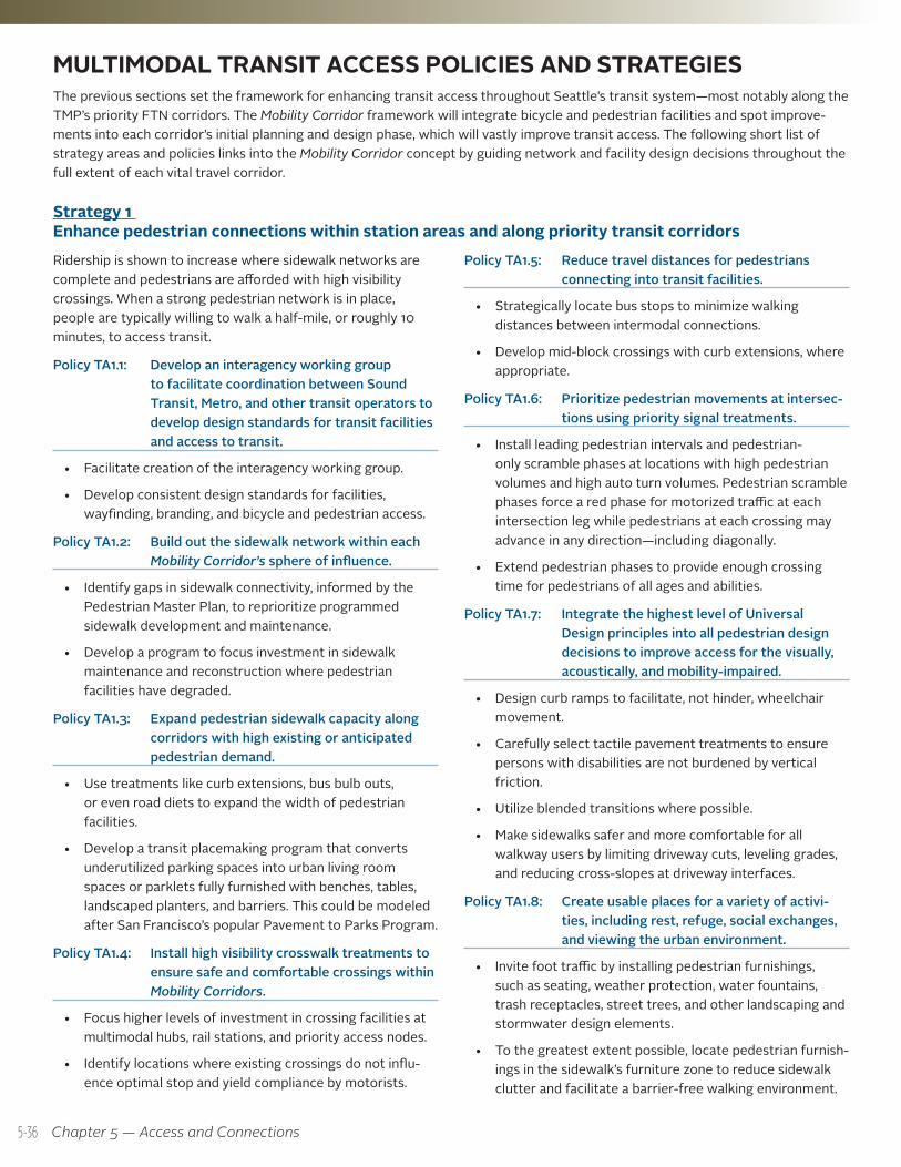
Chapter 5 — Access and Connections
MULTIMODAL TRANSIT ACCESS POLICIES AND STRATEGIES The previous sections set the framework for enhancing transit access throughout Seattle’s transit system—most notably along the TMP’s priority FTN corridors. The Mobility Corridor framework will integrate bicycle and pedestrian facilities and spot improve-ments into each corridor’s initial planning and design phase, which will vastly improve transit access. The following short list of strategy areas and policies links into the Mobility Corridor concept by guiding network and facility design decisions throughout the full extent of each vital travel corridor.
Strategy 1 Enhance pedestrian connections within station areas and along priority transit corridorsRidership is shown to increase where sidewalk networks are complete and pedestrians are afforded with high visibility crossings. When a strong pedestrian network is in place, people are typically willing to walk a half-mile, or roughly 10 minutes, to access transit.
Policy TA1.1: Develop an interagency working group to facilitate coordination between Sound Transit, Metro, and other transit operators to develop design standards for transit facilities and access to transit.
• Facilitate creation of the interagency working group.
• Develop consistent design standards for facilities, wayfinding, branding, and bicycle and pedestrian access.
Policy TA1.2: Build out the sidewalk network within each Mobility Corridor’s sphere of influence.
• Identify gaps in sidewalk connectivity, informed by the Pedestrian Master Plan, to reprioritize programmed sidewalk development and maintenance.
• Develop a program to focus investment in sidewalk maintenance and reconstruction where pedestrian facilities have degraded.
Policy TA1.3: Expand pedestrian sidewalk capacity along corridors with high existing or anticipated pedestrian demand.
• Use treatments like curb extensions, bus bulb outs, or even road diets to expand the width of pedestrian facilities.
• Develop a transit placemaking program that converts underutilized parking spaces into urban living room spaces or parklets fully furnished with benches, tables, landscaped planters, and barriers. This could be modeled after San Francisco’s popular Pavement to Parks Program.
Policy TA1.4: Install high visibility crosswalk treatments to ensure safe and comfortable crossings within Mobility Corridors.
• Focus higher levels of investment in crossing facilities at multimodal hubs, rail stations, and priority access nodes.
• Identify locations where existing crossings do not influ-ence optimal stop and yield compliance by motorists.
Policy TA1.5: Reduce travel distances for pedestrians connecting into transit facilities.
• Strategically locate bus stops to minimize walking distances between intermodal connections.
• Develop mid-block crossings with curb extensions, where appropriate.
Policy TA1.6: Prioritize pedestrian movements at intersec-tions using priority signal treatments.
• Install leading pedestrian intervals and pedestrian-only scramble phases at locations with high pedestrian volumes and high auto turn volumes. Pedestrian scramble phases force a red phase for motorized traffic at each intersection leg while pedestrians at each crossing may advance in any direction—including diagonally.
• Extend pedestrian phases to provide enough crossing time for pedestrians of all ages and abilities.
Policy TA1.7: Integrate the highest level of Universal Design principles into all pedestrian design decisions to improve access for the visually, acoustically, and mobility-impaired.
• Design curb ramps to facilitate, not hinder, wheelchair movement.
• Carefully select tactile pavement treatments to ensure persons with disabilities are not burdened by vertical friction.
• Utilize blended transitions where possible.
• Make sidewalks safer and more comfortable for all walkway users by limiting driveway cuts, leveling grades, and reducing cross-slopes at driveway interfaces.
Policy TA1.8: Create usable places for a variety of activi-ties, including rest, refuge, social exchanges, and viewing the urban environment.
• Invite foot traffic by installing pedestrian furnishings, such as seating, weather protection, water fountains, trash receptacles, street trees, and other landscaping and stormwater design elements.
• To the greatest extent possible, locate pedestrian furnish-ings in the sidewalk’s furniture zone to reduce sidewalk clutter and facilitate a barrier-free walking environment.
5-36
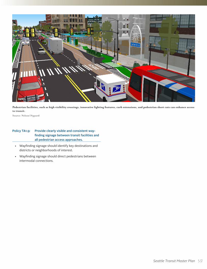
Seattle Transit Master Plan
Pedestrian facilities, such as high visibility crossings, innovative lighting features, curb extensions, and pedestrian short cuts can enhance access to transit.
Source: Nelson\Nygaard
Policy TA1.9: Provide clearly visible and consistent way-finding signage between transit facilities and all pedestrian access approaches.
• Wayfinding signage should identify key destinations and districts or neighborhoods of interest.
• Wayfinding signage should direct pedestrians between intermodal connections.
5-37
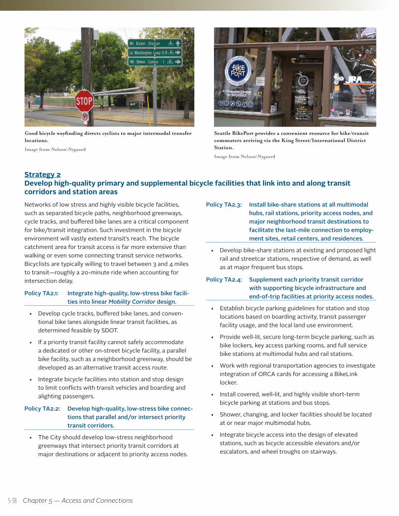
Chapter 5 — Access and Connections
Seattle BikePort provides a convenient resource for bike/transit commuters arriving via the King Street/International District Station.
Image from Nelson\Nygaard
Good bicycle wayfinding directs cyclists to major intermodal transfer locations.
Image from Nelson\Nygaard
Strategy 2 Develop high-quality primary and supplemental bicycle facilities that link into and along transit corridors and station areasNetworks of low stress and highly visible bicycle facilities, such as separated bicycle paths, neighborhood greenways, cycle tracks, and buffered bike lanes are a critical component for bike/transit integration. Such investment in the bicycle environment will vastly extend transit’s reach. The bicycle catchment area for transit access is far more extensive than walking or even some connecting transit service networks. Bicyclists are typically willing to travel between 3 and 4 miles to transit—roughly a 20-minute ride when accounting for intersection delay.
Policy TA2.1: Integrate high-quality, low-stress bike facili-ties into linear Mobility Corridor design.
• Develop cycle tracks, buffered bike lanes, and conven-tional bike lanes alongside linear transit facilities, as determined feasible by SDOT.
• If a priority transit facility cannot safely accommodate a dedicated or other on-street bicycle facility, a parallel bike facility, such as a neighborhood greenway, should be developed as an alternative transit access route.
• Integrate bicycle facilities into station and stop design to limit conflicts with transit vehicles and boarding and alighting passengers.
Policy TA2.2: Develop high-quality, low-stress bike connec-tions that parallel and/or intersect priority transit corridors.
• The City should develop low-stress neighborhood greenways that intersect priority transit corridors at major destinations or adjacent to priority access nodes.
Policy TA2.3: Install bike-share stations at all multimodal hubs, rail stations, priority access nodes, and major neighborhood transit destinations to facilitate the last-mile connection to employ-ment sites, retail centers, and residences.
• Develop bike-share stations at existing and proposed light rail and streetcar stations, respective of demand, as well as at major frequent bus stops.
Policy TA2.4: Supplement each priority transit corridor with supporting bicycle infrastructure and end-of-trip facilities at priority access nodes.
• Establish bicycle parking guidelines for station and stop locations based on boarding activity, transit passenger facility usage, and the local land use environment.
• Provide well-lit, secure long-term bicycle parking, such as bike lockers, key access parking rooms, and full service bike stations at multimodal hubs and rail stations.
• Work with regional transportation agencies to investigate integration of ORCA cards for accessing a BikeLink locker.
• Install covered, well-lit, and highly visible short-term bicycle parking at stations and bus stops.
• Shower, changing, and locker facilities should be located at or near major multimodal hubs.
• Integrate bicycle access into the design of elevated stations, such as bicycle accessible elevators and/or escalators, and wheel troughs on stairways.
5-38
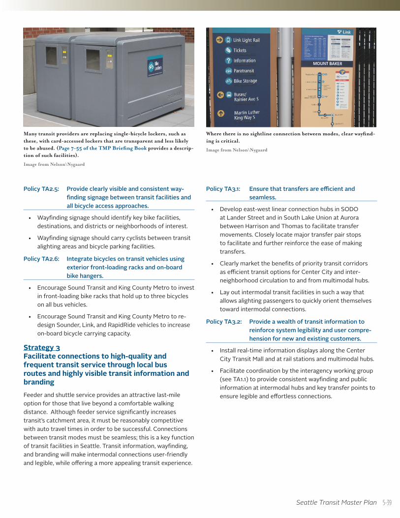
Seattle Transit Master Plan
Where there is no sightline connection between modes, clear wayfind-ing is critical.
Image from Nelson\Nygaard
Many transit providers are replacing single-bicycle lockers, such as these, with card-accessed lockers that are transparent and less likely to be abused. (Page 7-55 of the TMP Briefing Book provides a descrip-tion of such facilities).
Image from Nelson\Nygaard
Policy TA3.1: Ensure that transfers are efficient and seamless.
• Develop east-west linear connection hubs in SODO at Lander Street and in South Lake Union at Aurora between Harrison and Thomas to facilitate transfer movements. Closely locate major transfer pair stops to facilitate and further reinforce the ease of making transfers.
• Clearly market the benefits of priority transit corridors as efficient transit options for Center City and inter-neighborhood circulation to and from multimodal hubs.
• Lay out intermodal transit facilities in such a way that allows alighting passengers to quickly orient themselves toward intermodal connections.
Policy TA3.2: Provide a wealth of transit information to reinforce system legibility and user compre-hension for new and existing customers.
• Install real-time information displays along the Center City Transit Mall and at rail stations and multimodal hubs.
• Facilitate coordination by the interagency working group (see TA1.1) to provide consistent wayfinding and public information at intermodal hubs and key transfer points to ensure legible and effortless connections.
Policy TA2.5: Provide clearly visible and consistent way-finding signage between transit facilities and all bicycle access approaches.
• Wayfinding signage should identify key bike facilities, destinations, and districts or neighborhoods of interest.
• Wayfinding signage should carry cyclists between transit alighting areas and bicycle parking facilities.
Policy TA2.6: Integrate bicycles on transit vehicles using exterior front-loading racks and on-board bike hangers.
• Encourage Sound Transit and King County Metro to invest in front-loading bike racks that hold up to three bicycles on all bus vehicles.
• Encourage Sound Transit and King County Metro to re-design Sounder, Link, and RapidRide vehicles to increase on-board bicycle carrying capacity.
Strategy 3 Facilitate connections to high-quality and frequent transit service through local bus routes and highly visible transit information and branding Feeder and shuttle service provides an attractive last-mile option for those that live beyond a comfortable walking distance. Although feeder service significantly increases transit’s catchment area, it must be reasonably competitive with auto travel times in order to be successful. Connections between transit modes must be seamless; this is a key function of transit facilities in Seattle. Transit information, wayfinding, and branding will make intermodal connections user-friendly and legible, while offering a more appealing transit experience.
5-39