Embed Size (px)
Citation preview

Landscape Character Assessment,Sensitivity and Capacity Study North East Lincolnshire 41
5STAGE 1: CHARACTER OF THE NORTH EAST LINCOLNSHIRE LANDSCAPES
[Back to Contents]
INTRODUCTION
METHODOLOGY
OVERVIEW
1
2
4
LANDSCAPE CONTEXT3
FIGURES
APPENDICES
6
7
8
9
STAGE 2: SENSITIVITY & CAPACITY
KEY REFERENCES

Landscape Type 1: Industrial Landscape
Landscape Type 2: Open
Farmland
Landscape Type 3: Wooded Open
FarmlandLandscape Type 4: Flat Open Farmland
Landscape Type 5: Sloping
Farmland
Landscape Type 6:
High Farmland
North East Lincolnshire Landscape Character Assessment,Sensitivity and Capacity Study42
[Back to Contents]
CHARACTER OF THE NORTH EAST LINCOLNSHIRE LANDSCAPE5North East Lincolnshire Landscape Types Key Plan[Link to Figure 5 North East Lincolnshire Landscape Types] [Click on Landscape Type below to go to relevant Policy Sheet]

GRIMSBY/CLEETHORPES
North East Lincolnshire Landscape Character AssessmentStage 1: Character of the NE Lincs Landscapes
Landscape Type 1: Industrial Landscape
[Back to NE Lincs Landscape Types Key Plan)
Context:• NCA: Humber Estuary• County LCA: Humber Estuary• Historic LCZ: The Immingham
Coastal Marsh• Historic LCA: The Northern
Marshes
Designations:• None
[Back to Contents]
Key Characteristics:• Virtually fl at landform emphasising large skies• Large scale industrial works (including Immingham power station) and docks• Medium to large scale open arable farmland• Open views sometimes interrupted by large scale built development• High and low voltage pylons criss-crossing the area have an urbanising
effect• Network of busy roads including the main A180 transport route• Well established low cut native hedgerow fi eld boundaries with hedgerow
trees• Tall native hedgerows and mature trees along road corridors• Extensive network of fi eld drainage dykes including several large named
drains• Immingham town, northern periphery of Grimsby, scattered farmsteads
Landscape Character Assessment,Sensitivity and Capacity Study North East Lincolnshire 43

North East Lincolnshire Landscape Character AssessmentStage 1: Character of the NE Lincs Landscapes
Landscape Type 1: Industrial Landscape
[Back to NE Lincs Landscape Types Key Plan)
Location and Boundaries: The area lies immediately north and north-west of the main settlement of Grimsby. The north-eastern extent is defi ned by the North East Lincolnshire coastline which is protected by European and national designations (SAC/SSSI), the settlement edge of Grimsby lies to the east and south-east, the A180 transport corridor forms the southern boundary, open farmland lies to the west and Immingham oil refi neries are located to the north-west.
Landscape Character: A visually open and virtually fl at, low lying landscape heavily infl uenced by the large scale industrial works, docks and power station at Immingham to the north, together with part of Grimsby docks and industrial area to the east. Open views from the periphery of Immingham and the undeveloped areas extend towards the distinctive and imposing masts and chimneys associated with the docks, industry and power station set against the large skies which are further emphasised by the fl at landform. High and low voltage pylons criss-crossing the landscape create a visual detractor across the area. Despite the proximity of the industrial activity and docklands which is clearly visible, there is some sense of isolation away from the A180.
Geology: Underlying bedrock of Cretaceous Chalk. High quality soils give rise to productive arable farming.
Topography: Low lying, fl at landscape at approximately 5m AOD across the majority of the area, rising to 10m AOD in the north-western corner, to the west of Immingham.
Hydrology: No major watercourses are present. An extensive network of fi eld drainage dykes cross the area, along fi eld boundaries and include several large named drains, and are often not marked by vegetation. An angling lake is located at Homestead Park in the north-west.
Land Use and Settlement: Land use is a mix of industrial works within the north and east and arable farmland within the south and west. Fields are mostly medium scale, tending to be larger closer to Immingham, and have a regular pattern.
Immingham is the only settlement within the landscape type and lies close to the north-western edge. It comprises of predominantly mid to late 20th century and 21st century buildings, including several 1930s-1950s residential properties. The Oasis Academy is an example of large scale contemporary design at the centre of the town. A number of farmsteads are dispersed across the farmland to the east and west of the town as well as further east towards Grimsby.
Immingham Golf Club and Homestead Park (with angling lake) are located at the north-western edge of Immingham.
The A180 is the dominant transport route and the busy A1173 also crosses the western part of the landscape. Local roads serve the docks and industrial areas, while the Grimsby and Immingham Electric Railway which bisects the area connects the docklands. This network of busy roads has a strong urbanising effect upon the landscape character of the area. Public rights of way occur within and around Immingham, as well as within the industrial area to the east.
Tree Cover/Vegetation: Fields are defi ned by low cut, well established native hedgerows, which are generally intact and continuous, with hedgerow trees. Taller native hedgerows and mature trees align the roads, creating strong landscape buffers however these appear more gappy closer to the industrial activity.
Very few woodland blocks occur within the area, however scattered trees are apparent within the agricultural farmland. Vegetation tends to be more ornamental within and around the industrial areas, often associated with car parking and boundaries.
Historic Environment: The medieval pattern of settlement is very well preserved. Ancient enclosures evident on the periphery of historic settlements often retain the sinuous boundaries that are indicative of early enclosure of arable strip farming. The area is characterised by the extensive survival of planned enclosure which has created a strongly rectilinear pattern in the landscape. The long straight roads are also well preserved throughout the area. Modern industrial development such as the Immingham Docks respects the orientation and rectilinear form of the underlying pattern of enclosure and internal roads tend to follow the lines of former fi eld boundaries.
Pressures for Change/Key Issues: Post war agricultural intensifi cation has led to the removal and frequent cutting of hedgerows in intensively farmed areas as well as the loss of hedgerow trees. Development pressures from the industrial and settlement fringes and connecting busy roads crossing the area, particularly the A180. There are also pressures from potential future wind energy development.
[Back to Contents]
North East Lincolnshire Landscape Character AssessmentStage 1: Character of the NE Lincs Landscapes
Landscape Type 1: Industrial Landscape
[Back to NE Lincs Landscape Types Key Plan) [Back to Contents]
Condition: The condition of the landscape is considered to be poor. While the fi eld pattern is regular it has been signifi cantly eroded by fi eld amalgamation, defi ned by some hedgerows and, more predominantly, an intensive network of drainage dykes. The pattern of elements is incoherent with many detracting features across the area. There is some cultural integrity; the Immingham Docks, historic settlement pattern and planned enclosure landscape. Ecological connectivity is apparent resulting in little integrity overall and the functional integrity of the landscape is generally poor.
Character: The area has a distinctive character overall as a result of the docks, the fl at landform and subsequent large skies combining to create some dramatic views. Historic associations are present in the form of some evidence of the historic fi eld, settlement and road patterns. Overall the sense of place is strong. The fl at landform and lack of tree cover allows high visibility across the landscape.
North East Lincolnshire Landscape Character Assessment,Sensitivity and Capacity Study44

North East Lincolnshire Landscape Character AssessmentStage 1: Character of the NE Lincs Landscapes
Landscape Type 1: Industrial Landscape
[Back to NE Lincs Landscape Types Key Plan) [Back to Contents]
Condition: The condition of the landscape is considered to be poor. While the fi eld pattern is regular it has been signifi cantly eroded by fi eld amalgamation, defi ned by some hedgerows and, more predominantly, an intensive network of drainage dykes. The pattern of elements is incoherent with many detracting features across the area. There is some cultural integrity; the Immingham Docks, historic settlement pattern and planned enclosure landscape. Ecological connectivity is apparent resulting in little integrity overall and the functional integrity of the landscape is generally poor.
Character: The area has a distinctive character overall as a result of the docks, the fl at landform and subsequent large skies combining to create some dramatic views. Historic associations are present in the form of some evidence of the historic fi eld, settlement and road patterns. Overall the sense of place is strong. The fl at landform and lack of tree cover allows high visibility across the landscape.
Landscape Character Assessment,Sensitivity and Capacity Study North East Lincolnshire 45

North East Lincolnshire Landscape Character AssessmentStage 1: Character of the NE Lincs Landscapes
Landscape Type 1: Industrial Landscape
[Back to NE Lincs Landscape Types Key Plan) [Back to Contents]
Landscape Guidelines / Management Strategies• New development should reinforce the existing settlement pattern of Immingham town, which encompasses a
relatively tight and uniform arrangement of properties, retaining the peripheral semi-rural character of scattered farmsteads;
• Settlement expansion should be of an appropriate scale to the local context with a robust landscape buffer, including appropriate landscape planting, to integrate the settlement edge within the landscape and limit its encroachment;
• New agricultural buildings should be designed, sited and landscaped to integrate with the surrounding context and landscape character and minimise their impact;
• New high or bulky structures, including industrial or wind energy development, should be subject to a rigorous LVIA and designed and sited with careful consideration to minimise their impact, particularly on the AONB;
• Avoid types of farm diversifi cation that are inappropriate to the agricultural landscape;• Conserve open views of large skies emphasised by the fl at landform;• Conserve and enhance the character and setting of listed buildings;• Encourage introduction and appropriate management of wide fi eld margins along fi eld boundaries; • Conserve, restore and enhance the historic fi eld pattern wherever practicable with priority given to restoring
and strengthening primary hedge lines including those alongside roads; • Manage hedgerows to enhance the fi eld pattern by planting up gaps, allow hedges to grow by reducing cut
rotation intervals to every three years to benefi t local wildlife;• Promote management of woodland; long rotation coppicing may be appropriate in places;• Enhance tree cover through small scale planting of broadleaved coverts and woods in keeping with the visually
open character;• Promote small areas of wetland planting in areas currently lacking in habitats; and• Encourage ecological management of grassland areas and wetlands.
North East Lincolnshire Landscape Character Assessment,Sensitivity and Capacity Study46

GRIMSBY/CLEETHORPES
[Back to NE Lincs Landscape Types Key Plan)
North East Lincolnshire Landscape Character AssessmentStage 1: Character of the NE Lincs Landscapes
Landscape Type 2: Open Farmland
Context:• NCA: Lincolnshire Coast and
Marshes• County LCA: Lincolnshire Coast
and Marshes• Historic LCA: The Grimsby
Commuter Belt / The Humber Bank
Designations:• Conservation Area: Great Coates
[Back to Contents]
Key Characteristics:• Virtually fl at landform emphasising large skies• Medium to large scale open arable farmland• Open views towards settlement edges and industry/docks• High voltage pylons have an urbanising effect• Network of busy roads including the main A180 transport route and the
Grimsby to Doncaster railway line• Mature native hedgerow fi eld and roadside boundaries with hedgerow trees,
particularly in the north, tending to become sparse and gappy to the north and west of Healing
• Extensive network of fi eld drainage dykes including Main Drain• Village settlements of Healing, Stallingborough and Habrough, scattered
farmsteads
Landscape Character Assessment,Sensitivity and Capacity Study North East Lincolnshire 47

[Back to NE Lincs Landscape Types Key Plan)
North East Lincolnshire Landscape Character AssessmentStage 1: Character of the NE Lincs Landscapes
Landscape Type 2: Open Farmland
Location and Boundaries: The area lies immediately north-west of the main settlement of Grimsby. The A180 transport corridor defi nes the northern extent while open farmland lies to the north-west, west and south and the settlement edge of Grimsby to the east. A section of the southern boundary is defi ned by the Grimsby to Doncaster railway line where it bisects the settlement of Stallingborough which falls partly within the landscape type.
Landscape Character: A visually open, low lying landscape with large skies. This is further emphasised by the fl at medium to large scale arable farmland and limited development. Views are generally open across the landscape towards adjacent landscape types, with Immingham docks, industrial areas and the power station distantly visible against large skies to the east. Visibility becomes more restricted and contained within settlement areas due to built development. High voltage pylons crossing the central and south-western edges create a visual detractor from the fl at rural landscape.
Geology: Cretaceous Chalk with later Quaternary sand, gravel and clay deposits. Slowly permeable, seasonally waterlogged fi ne and fertile loamy soils.
Topography: Flat coastal plain, rising from approximately 5m AOD in the east to 10m AOD at the western extent. Landform rises from 15-20m AOD in localised areas between Habrough and Stallingborough Road.
Hydrology: No major watercourses are present. An extensive network of fi eld drainage dykes cross the area, along fi eld boundaries including Middle Drain to the west of Stallingborough, and are often not marked by vegetation.
Land Use and Settlement: The dominant land use is arable farmland with some pasture evident within the east, to the north-west of the main settlement area of Grimsby. Fields are medium to large scale and of a regular pattern affording a relatively uniform and simple appearance overall.
Three settlements are separated by agricultural farmland; Habrough within the north-west, Stallingborough (northern part) and Healing within the east. Both Habrough and Stallingborough include occasional vernacular buildings however examples are more prevalent within Healing. Several farmsteads and individual properties are dispersed throughout. Great Coates Conservation Area encroaches into the landscape along the eastern edge of the area/interface with Great Coates, a suburb at the north-western fringe of Grimsby.
A network of busy transport routes cross the area including the Grimsby to Doncaster railway line, which bisects the landscape in an east to west direction, together with the A180, A1136 and B1210 road corridors which connect the settlements with the surrounding area and Grimsby to the east. The public right of way network is largely concentrated to the east, although a footpath follows the railway line for the majority of its length.
Tree Cover/Vegetation: Mature native hedgerows with some hedgerow trees defi ne the fi eld and roadside boundaries in the northern part of the area, towards Habrough. Field boundaries tend to become sparse and gappy to the north and west of Healing with few hedgerow trees evident however roadside vegetation is well established and the settlement itself is particularly well treed featuring strong tree lined avenues. There is a small amount of woodland cover mostly occurring within the west adjacent to the railway line which is on an embankment.
Historic Environment: The settlement pattern presently retains most of its historic character and the rural landscape retains a high degree of planned enclosure landscape. The settlement pattern retains its historic character, historic cores remain evident and include local buildings materials. Most of the planned landscape survives and some of the 18th century fi eld pattern remains unchanged. Where boundaries have been removed the underlying rectilinear character is identifi able from fi eld drains.
Pressures for Change/Key Issues: Post war agricultural intensifi cation has led to the removal and frequent cutting of hedgerows in intensively farmed areas as well as the loss of hedgerow trees, further loss may cause erosion of planned enclo-sure landscapes. Development pressures from the settlement fringes including the north-western fringe of Grimsby and con-necting busy roads crossing the area, particularly the A180. Potential for coalescence of settlements; the north-western edge of Grimsby with Healing as well as Healing with Stallingborough. There are also pressures from potential future wind energy development.
[Back to Contents]
North East Lincolnshire Landscape Character Assessment,Sensitivity and Capacity Study48

[Back to NE Lincs Landscape Types Key Plan)
North East Lincolnshire Landscape Character AssessmentStage 1: Character of the NE Lincs Landscapes
Landscape Type 2: Open Farmland
[Back to Contents]
Condition: The condition of the landscape is considered to be moderate with a regular fi eld pattern, partly eroded by fi eld amalgamation, defi ned by hedgerows and a network of drainage dykes. The pattern of elements is coherent however there are some detracting features across the area. There is some cultural integrity; the historic settlement pattern and planned enclosure landscape. Ecological connectivity is moderate resulting in some integrity overall and the functional integrity of the landscape is generally good.
Character: The area has a distinctive character overall as a result of the fl at landform and subsequent large skies. Historic associations are present in the form of some evidence of the historic fi eld pattern and historic settlement cores where local building materials are apparent. Overall the sense of place is strong. The fl at landform allows high visibility across the landscape.
Landscape Character Assessment,Sensitivity and Capacity Study North East Lincolnshire 49

[Back to NE Lincs Landscape Types Key Plan)
North East Lincolnshire Landscape Character AssessmentStage 1: Character of the NE Lincs Landscapes
Landscape Type 2: Open Farmland
[Back to Contents]
Landscape Guidelines / Management Strategies• New development should reinforce the existing settlement pattern, retaining the semi-rural/rural character of
nucleated villages, which generally encompass a relatively tight and uniform arrangement of properties, with scattered farmsteads;
• Settlement expansion should be of an appropriate scale to the local context with a robust landscape buffer, including appropriate landscape planting, to integrate the settlement edge within the landscape and limit its encroachment;
• New agricultural buildings should be designed, sited and landscaped to integrate with the surrounding context and landscape character;
• New high or bulky structures, including wind energy development, should be subject to a rigorous LVIA and designed and sited with careful consideration to minimise their impact, particularly their potential visual impact on the AONB;
• Avoid types of farm diversifi cation that are inappropriate to the agricultural landscape;• Conserve open views of large skies emphasised by the fl at landform and limited built development;• Conserve and enhance the character and setting of Great Coates Conservation Area as well as any listed
buildings;• Encourage introduction and appropriate management of wide fi eld margins along fi eld boundaries; • Conserve, restore and enhance the historic fi eld pattern wherever practicable with priority given to restoring
and strengthening primary hedge lines including those alongside roads; • Manage hedgerows to enhance the fi eld pattern by planting up gaps, allow hedges to grow by reducing cut
rotation intervals to every three years to benefi t local wildlife;• Promote management of woodland; long rotation coppicing may be appropriate in places;• Enhance tree cover through small scale planting of broadleaved coverts and woods in keeping with the visually
open character;• Promote small areas of wetland planting in areas currently lacking in habitats; and• Encourage ecological management of grassland areas and wetlands.
GRIMSBY/CLEETHORPES
North East Lincolnshire Landscape Character AssessmentStage 1: Character of the NE Lincs Landscapes
Landscape Type 3: Wooded Open Farmland
[Back to NE Lincs Landscape Types Key Plan)
Context:• NCA: Lincolnshire Coast and
Marshes• County LCA: Lincolnshire Coast
and Marshes• Historic LCA: The Grimsby
Commuter Belt / The Humber Bank
Designations:• Scheduled Monuments:
Stallingborough medieval settlement / Healing Manor moated sites
• Conservation Areas: Laceby / Cottagers Plot
• Local Nature Reserve: Bradley Wood / Dixon Wood
[Back to Contents]
Key Characteristics:• Virtually fl at landform emphasising large skies, though some gentle
undulations are evident• Medium to large scale open arable farmland• Open views sometimes interrupted by woodland blocks• High and low voltage pylons have an urbanising effect• Network of busy roads including the A46, A1173, B1210 but also a network
of quiet local lanes• Well established low cut native hedgerow fi eld and roadside boundaries with
hedgerow trees• Tall native hedgerows and mature trees along lanes• Internal hedgerows tend to be more sparse and fragmented around Aylesby
and east of Laceby• Small watercourses; North Beck Drain, Laceby Beck, Waithe Beck, and an
extensive network of fi eld drainage dykes• Nucleated settlement pattern of villages and hamlets, scattered farmsteads• The Wanderlust Way (local trail)
North East Lincolnshire Landscape Character Assessment,Sensitivity and Capacity Study50

GRIMSBY/CLEETHORPES
North East Lincolnshire Landscape Character AssessmentStage 1: Character of the NE Lincs Landscapes
Landscape Type 3: Wooded Open Farmland
[Back to NE Lincs Landscape Types Key Plan)
Context:• NCA: Lincolnshire Coast and
Marshes• County LCA: Lincolnshire Coast
and Marshes• Historic LCA: The Grimsby
Commuter Belt / The Humber Bank
Designations:• Scheduled Monuments:
Stallingborough medieval settlement / Healing Manor moated sites
• Conservation Areas: Laceby / Cottagers Plot
• Local Nature Reserve: Bradley Wood / Dixon Wood
[Back to Contents]
Key Characteristics:• Virtually fl at landform emphasising large skies, though some gentle
undulations are evident• Medium to large scale open arable farmland• Open views sometimes interrupted by woodland blocks• High and low voltage pylons have an urbanising effect• Network of busy roads including the A46, A1173, B1210 but also a network
of quiet local lanes• Well established low cut native hedgerow fi eld and roadside boundaries with
hedgerow trees• Tall native hedgerows and mature trees along lanes• Internal hedgerows tend to be more sparse and fragmented around Aylesby
and east of Laceby• Small watercourses; North Beck Drain, Laceby Beck, Waithe Beck, and an
extensive network of fi eld drainage dykes• Nucleated settlement pattern of villages and hamlets, scattered farmsteads• The Wanderlust Way (local trail)
Landscape Character Assessment,Sensitivity and Capacity Study North East Lincolnshire 51

North East Lincolnshire Landscape Character AssessmentStage 1: Character of the NE Lincs Landscapes
Landscape Type 3: Wooded Open Farmland
[Back to NE Lincs Landscape Types Key Plan) [Back to Contents]
Location and Boundaries: The area lies immediately west and south-west of the main settlement of Grimsby which defi nes its north-eastern extent. The eastern edge is defi ned by Waltham village and open fi elds which also wrap around the south-eastern edge. Open farmland encompasses the north-western and western edge which is also partly defi ned by a short section of the A18 and A46. Farmland borders the south-western boundary which is also defi ned by the subtle change in landform as it begins to steadily rise further south-west, beyond the boundary.
Landscape Character: Predominantly a visually open, low lying landscape emphasised by the virtually fl at landform of medium to large scale arable farmland and large skies. The landscape is interspersed with woodland blocks which limit views in some directions. Otherwise views are generally quite open with some extensive visibility across the landscape towards adjacent landscape types. Views are more restricted within settlement areas due to containment provided by built development and mature vegetation. High and low voltage pylons cross the area in several places creating an urbanising effect and a small scale wind turbine is prominent on higher ground at Pyewipe Farm, though this is not considered to be inappropriate to the predominantly rural landscape character.
Geology: Cretaceous Chalk with later Quaternary sand, gravel and clay deposits. Slowly permeable, seasonally waterlogged fi ne and fertile loamy soils.
Topography: Flat coastal plain, broadly lying at between 10m and 20m AOD rising further south where the settlements of Barnoldby-le-Beck and Ashby-cum-Fenby lie at approximately 25m to 30m AOD. Both Aylesby and Laceby lie at approximately 20m AOD and there is localised higher ground of 25m AOD to the north of these. Landform rises gradually in the west towards sloping and undulating land at the foot of the Lincolnshire Wolds.
Hydrology: No major watercourses are present. Small watercourses include North Beck Drain (north), Laceby Beck (centre) and Waithe Beck (south). An extensive network of fi eld drainage dykes cross the area, often not marked by vegetation. There are ponds associated with farms as well as an angling lake at Laceby Manor caravan and camping site.
Land Use and Settlement: The dominant land use is arable farmland. Fields are medium to large scale and of a regular pattern affording a relatively uniform and simple appearance overall.
A nucleated settlement pattern comprises of villages and hamlets; the southern part of Stallingborough, Aylesby, Laceby, Bradley, Barnoldby-le-Beck, Brigsley and Ashby-cum-Fenby with examples of local vernacular prevalent at the historic core of Laceby, a designated Conservation Area, and Cottagers Plot Conservation Area further east, close to the western edge of Grimsby. Occasional examples of the local vernacular are evident within the smaller settlement areas where churches are also locally prominent. The southern part of Stallingborough is predominantly non-vernacular in style. Properties are generally clustered around or alongside, yet set well back from, the main roads passing through Aylesby, Bradley, Barnoldby-le-Beck, Brigsley and Ashby-cum-Fenby. A number of isolated farmsteads are dispersed throughout the landscape.
Two Scheduled Monuments are located within the north of the area, adjacent to Stallingborough and Healing; Stallingborough medieval settlement (post medieval manor house and formal gardens) adjacent to the church, and two moated sites at Healing Manor (grade II listed building). These designations are locally visible but do not feature prominently within the wider landscape. Laceby Manor Golf Club, caravan and camping site lies south of Laceby.
The majority of roads and lanes radiate from Grimsby and its outskirts, passing through the area in a north to south or east to west direction. Urban infl uences of busy roads include the A46, A1173 and B1210, local lanes are comparatively quieter overall. The area is well served by public rights of way including the Wanderlust Way (local trail) which traverses the southern half of the landscape reaching the periphery of Bradley and passing through Barnoldby-le-Beck, Brigsley and Ashby-cum-Fenby.
Tree Cover/Vegetation: Fields and roads are delineated by well established, often low cut, native hedgerows with hedgerow trees, and taller hedgerows with prominent hedgerow trees occurring along local lanes. Internal hedgerows tend to be sparse and fragmented within the central and eastern parts of the area, particularly around Aylesby and east of Laceby. Large scale woodland blocks, including Bradley and Dixon LNR (also Ancient Woodland), The Gairs (Ancient Woodland) and woodland partly containing Barnoldby-le-Beck occur within the centre. Additional smaller blocks of woodland, coverts, copses and tree belts are dotted throughout, yet more concentrated within the north and centre. Aylesby Park, at the south-western edge of Aylesby, encompasses scattered mature parkland trees.
Historic Environment: The settlement pattern presently retains most of its historic character and the rural landscape retains a high degree of planned enclosure landscape, particularly around Waltham. The settlement pattern retains its historic character, historic cores remain evident and include local building materials. Most of the planned landscape survives and some of the 18th century fi eld pattern remains unchanged. Where boundaries have been removed the underlying rectilinear character is identifi able from fi eld drains.
Pressures for Change/Key Issues: Post war agricultural intensifi cation has led to the removal and frequent cutting of hedgerows in intensively farmed areas as well as the loss of hedgerow trees, further loss may cause erosion of planned enclosure landscapes. Development pressures from the fringes of Grimsby, Waltham, Laceby and Healing and connecting busy roads as well as development pressures on the small scale settlements which are integral to the character of the area. Potential for coalescence of settlements; western and south-western edge of Waltham with Barnoldby-le-Beck and Brigsley. There are also pressures from potential future wind energy development.
North East Lincolnshire Landscape Character Assessment,Sensitivity and Capacity Study52

North East Lincolnshire Landscape Character AssessmentStage 1: Character of the NE Lincs Landscapes
Landscape Type 3: Wooded Open Farmland
[Back to NE Lincs Landscape Types Key Plan) [Back to Contents]
Condition: The condition of the landscape is considered to be good with a regular fi eld pattern, though partly eroded by fi eld amalgamation, defi ned by hedgerows and drainage dykes. The pattern of elements is coherent with few detracting features over the area. There is good cultural integrity; Stallingborough medieval settlement and Healing Manor moated sites, the historic settlement pattern and planned enclosure landscape. Ecological connectivity is good throughout the area with several woodlands including two locally designated habitats resulting in a good integrity overall and the functional integrity of the landscape is strong.
Character: The area has a distinctive character overall as a result of the fl at landform and subsequent large skies. Historic associations are present in the form of the Stallingborough medieval settlement and two moated sites at Healing Manor, all designated Scheduled Monuments, evidence of the historic fi eld pattern and historic settlement cores where local building materials are apparent. Overall the sense of place is strong. The fl at landform generally affords high visibility however this is sometimes interrupted by woodland.
Landscape Character Assessment,Sensitivity and Capacity Study North East Lincolnshire 53

North East Lincolnshire Landscape Character AssessmentStage 1: Character of the NE Lincs Landscapes
Landscape Type 3: Wooded Open Farmland
[Back to NE Lincs Landscape Types Key Plan) [Back to Contents]
Landscape Guidelines / Management Strategies• New development should reinforce the existing settlement pattern, retaining the semi-rural/rural character
of nucleated villages, which tend to encompass a tight and uniform arrangement of properties, and hamlets, which are much looser in character, with scattered farmsteads;
• Settlement expansion should be of an appropriate scale to the local context with a robust landscape buffer, including appropriate landscape planting, to integrate the settlement edge within the landscape and limit its encroachment;
• New agricultural buildings should be designed, sited and landscaped to integrate with the surrounding context and landscape character;
• New high or bulky structures, including wind energy development, should be subject to a rigorous LVIA and designed and sited with careful consideration to minimise their impact, particularly their potential visual impact on the AONB;
• Avoid types of farm diversifi cation that are inappropriate to the agricultural landscape;• Conserve open views of large skies emphasised by the fl at landform and limited built development;• Conserve and enhance the character and setting of Laceby and Cottagers Plot Conservation Areas as well as
any listed buildings;• Conserve and enhance Stallingborough medieval settlement and Healing moated sites (SMs), raise public
awareness through interpretation; • Conserve and enhance the Wanderlust Way for informal recreation and nature conservation;• Conserve, restore and enhance parkland at Aylesby Park;• Encourage introduction and appropriate management of wide fi eld margins along North Beck Drain, Laceby
Beck, Waithe Beck and fi eld boundaries; • Conserve, restore and enhance the historic fi eld pattern wherever practicable with priority given to restoring
and strengthening primary hedge lines including those alongside roads and lanes; • Manage hedgerows to enhance the fi eld pattern by planting up gaps, allow hedges to grow by reducing cut
rotation intervals to every three years to benefi t local wildlife;• Promote management of woodland blocks, copses and tree belts; long rotation coppicing may be appropriate
in places;• Enhance tree cover through small scale planting of broadleaved coverts and woods in keeping with the visually
open character;• Encourage management of the North Beck Drain, Laceby Beck and Waithe Beck corridors in accordance
with core principles of the Lincolnshire Chalk Streams Project (LCSP), refer to management objectives and implement where feasible;
• Encourage ecological management of grassland areas and wetlands; and• Refer to specifi c management plans for Bradley Wood and Dixon Wood LNRs and implement objectives where
feasible.
North East Lincolnshire Landscape Character Assessment,Sensitivity and Capacity Study54

GRIMSBY/CLEETHORPES
[Back to NE Lincs Landscape Types Key Plan)
North East Lincolnshire Landscape Character AssessmentStage 1: Character of the NE Lincs Landscapes
Landscape Type 4: Flat Open Farmland
Context:• NCA: Lincolnshire Coast and
Marshes• County LCA: Lincolnshire Coast
and Marshes / Humber Estuary• Historic LCA: Grimsby Commuter
Belt
Designations:• Scheduled Monument: Humberston
Abbey• Conservation Areas: Waltham /
Humberston / Humberston Fitties• Local Nature Reserves: Weelsby
Woods / Carr Plantation / Cleethorpes Country Park
[Back to Contents]
Key Characteristics:• Virtually fl at landform, more open and exposed in the south further
emphasising large skies• Medium to large scale open arable farmland• Open views, more limited in the north by roadside vegetation, urban fringe
and woodland• Urban fringe, industrial area, high and low voltage pylons have an urbanising
effect• Network of busy roads including the A16, A1098, B1219 but also a network
of quieter local lanes• Well established low cut native hedgerow fi eld boundaries with occasional
hedgerow trees, hedgerows tend to be fragmented and less frequent overall in the north due to larger fi eld sizes
• Roadside native hedgerows often low cut in the north and taller in the south• Small watercourse; Buck Beck and an extensive network of fi eld drains
sometimes marked by individual trees• Large villages clustered along the B1219, scattered farmsteads
Landscape Character Assessment,Sensitivity and Capacity Study North East Lincolnshire 55
[Back to NE Lincs Landscape Types Key Plan)
North East Lincolnshire Landscape Character AssessmentStage 1: Character of the NE Lincs Landscapes
Landscape Type 4: Flat Open Farmland
[Back to Contents]
Location and Boundaries: The area lies immediately south of the main settlements of Grimsby and Cleethorpes which defi ne its northern extent. To the east is the North East Lincolnshire coastline which is protected by European and national designations (SAC/SSSI). Open farmland wraps around the southern and western extents and the suburb of Scartho defi nes the north-western edge.
Landscape Character: A fl at, low lying, visually open landscape however views are more limited in the north by roadside vegetation, the urban edges and woodland. Views are generally only available via gaps in taller vegetation or across the low cut hedgerows. There is greater visibility in the south where the landscape is more open and exposed and the characteristic large skies are further emphasised. Views of Humberston church and Waltham Windmill, a distinctive local landmark, are available. The urban fringes of Scartho, Grimsby and Cleethorpes, Humberston Industrial Estate and Tesco as well as high voltage pylons passing through the northern part of the area have an urbanising effect on this part of the landscape. Overall, the landscape surrounding the settlements and urban fringe is busier, becoming quieter further south in the more remote areas.
Geology: Cretaceous Chalk with later Quaternary sand, gravel and clay deposits. Slowly permeable, seasonally waterlogged fi ne and fertile loamy soils.
Topography: Flat coastal plain, broadly lying at between 10m and 15m AOD. Landform is lower lying at the eastern and south-eastern periphery nearer the coastline and rises gently west and north-west towards Humberston which lies at approximately 15m AOD. The landform rises again closer to Waltham, which lies at approximately 15-20m AOD, and the south-western edge of the area
Hydrology: No major watercourses are present. Buck Beck follows a central course through the area and there is an extensive network of fi eld drainage dykes crossing the area, sometimes marked by individual trees. A large angling lake is encompassed within Cleethorpes Country Park.
Land Use and Settlement: Predominantly arable farmland with a central spine of connected settlements. Fields are medium to large scale and of a regular pattern. Overall, the landscape has an organised appearance.
Large villages; Waltham, New Waltham and Humberston, dominate the centre, east and west of the area, largely comprising of non-vernacular residential development. This is concentrated around the historic cores and Conservation Areas of Waltham and Humberston which include examples of local vernacular. Several farmsteads are dispersed throughout the landscape however a greater number occur within the north.
A Scheduled Monument; Humberston Abbey is also encompassed within Humberston Conservation Area and is located adjacent to the church, it is locally visible but does not form a prominent feature within the wider landscape. Cleethorpes Country Park LNR and Golf Club, Pleasure Island Theme Park and the unique and characterisic Humberston Fitties Conservation Area defi ne the north-eastern and eastern edges of this landscape type. Waltham Windmill Golf Club and the disused Waltham Airfi eld are located within the south-western corner and are largely contained by mature vegetation. Humberston Park Golf Club is located at the south-eastern edge of New Waltham and is also enclosed by vegetation.
The landscape is fragmented by a network of busy roads running north to south and east to west, including the A16 which provides the main link to Grimsby and the A1098 which is the main connection to Cleethorpes. The B1219 cuts east to west through the majority of the area, forming the spine road for Waltham and New Waltham as well as connecting to Humberston. It is accentuated by avenue tree planting along much of the route. A network of interconnecting lanes further serve the settlements and tourist areas to the east. Public rights of way provide connectivity across the majority of the landscape.
Tree Cover/Vegetation: Agricultural fi elds are mainly defi ned by low cut native hedgerows which are generally intact, though often gappy where they occur within the north. Overall, internal hedgerows tend to be less frequent in the north due to larger fi eld sizes which are sometimes delineated by individual trees along drainage ditches. Local roads are bordered by native hedgerows which are typically low cut in the north and taller in the south. Occasional hedgerow trees occur but tend to be less prominent than in adjacent landscape types. Woodland blocks, including Weelsby Woods and Carr Plantation LNRs, are concentrated within the northern part of the area and afford some screening of the urban fringe of Grimsby. Similarly, Cleethorpes Country Park, also a LNR, provides a strong buffer between the southern edge of Cleethorpes and the settlement of Humberston.
Historic Environment: The settlement pattern presently retains most of its historic character and the rural landscape retains a high degree of planned enclosure landscape, particularly around Waltham and Humberston.
Pressures for Change/Key Issues: Post war agricultural intensifi cation has led to the removal and frequent cutting of hedgerows in intensively farmed areas as well as the loss of hedgerow trees, further loss may cause erosion of planned enclosure landscapes. Development pressures from the southern fringe of Grimsby and Cleethorpes as well as the settlements within the landscape type and connecting busy roads crossing the area. Potential for coalescence of settlements; the southern edge of Grimsby and Cleethorpes with Waltham, New Waltham and Humberston. There are also pressures from potential future wind energy development.
North East Lincolnshire Landscape Character Assessment,Sensitivity and Capacity Study56

[Back to NE Lincs Landscape Types Key Plan)
North East Lincolnshire Landscape Character AssessmentStage 1: Character of the NE Lincs Landscapes
Landscape Type 4: Flat Open Farmland
[Back to Contents]
Condition: The condition of the landscape is considered to be moderate with a regular fi eld pattern, partly eroded by fi eld amalgamation, defi ned by hedgerows which are often gappy and a network of drainage dykes. The pattern of elements is coherent however there are some detracting features over the area. There is good cultural integrity; Humberston Abbey, the historic settlement pattern and a high degree of planned enclosure landscape. Ecological integrity is good as a result of the locally designated sites and good connectivity and there is some functional integrity.
Character: The area has a distinctive character at its eastern and north-eastern periphery where the Humberston Fitties and tourist attractions are located. Historic associations are present and include Humberston Abbey Scheduled Monument, evidence of the historic fi eld pattern and historic settlement cores. Overall the sense of place is moderate but stronger at the eastern edges. The virtually fl at landform and sparse tree cover affords a relatively high degree of visibility from the more open areas resulting in high visibility overall.
Landscape Character Assessment,Sensitivity and Capacity Study North East Lincolnshire 57

[Back to NE Lincs Landscape Types Key Plan)
North East Lincolnshire Landscape Character AssessmentStage 1: Character of the NE Lincs Landscapes
Landscape Type 4: Flat Open Farmland
[Back to Contents]
Landscape Guidelines / Management Strategies• New development should reinforce the existing settlement pattern of large villages, encompassing a relatively
tight and uniform arrangement of properties, separated by agricultural farmland, retaining the semi-rural character of scattered farmsteads;
• Settlement expansion should be of an appropriate scale to the local context with a robust landscape buffer, including appropriate landscape planting, to integrate the settlement edge within the landscape and limit its encroachment;
• New agricultural buildings should be designed, sited and landscaped to integrate with the surrounding context and landscape character;
• New high or bulky structures, including industrial or wind energy development, should be subject to a rigorous LVIA and designed and sited with careful consideration to minimise their impact, particularly their potential visual impact on the AONB;
• Avoid types of farm diversifi cation that are inappropriate to the agricultural landscape;• Conserve open views generally and views towards distinctive features including Waltham Windmill and
Humberston church;• Conserve and enhance the character and setting of Waltham, Humberston and the Humberston Fitties
Conservation Areas as well as any listed buildings;• Conserve and enhance Humberston Abbey (SM), raise public awareness through interpretation; • Conserve and enhance Cleethorpes Country Park as a public amenity, in accordance with management aims
and objectives; • Encourage introduction and appropriate management of wide fi eld margins along Buck Beck and fi eld
boundaries; • Conserve, restore and enhance the historic fi eld pattern wherever practicable with priority given to restoring
and strengthening primary hedge lines including those alongside roads and lanes; • Manage hedgerows to enhance the fi eld pattern by planting up gaps, allow hedges to grow by reducing cut
rotation intervals to every three years to benefi t local wildlife;• Promote management of woodland, copses and tree belts; long rotation coppicing may be appropriate in
places;• Enhance tree cover through small scale planting of broadleaved coverts and woods in keeping with the visually
open character;• Encourage management of the Buck Beck corridor in accordance with core principles of the Lincolnshire Chalk
Streams Project (LCSP), refer to management objectives and implement where feasible;• Encourage ecological management of grassland areas and wetlands; and• Refer to specifi c management plans for Weelsby Woods, Carr Plantation, Cleethorpes Country Park LNRs and
implement objectives where feasible.
North East Lincolnshire Landscape Character Assessment,Sensitivity and Capacity Study58

GRIMSBY/CLEETHORPES
North East Lincolnshire Landscape Character AssessmentStage 1: Character of the NE Lincs Landscapes
Landscape Type 5: Sloping Farmland
[Back to NE Lincs Landscape Types Key Plan)
Context:• NCA: Lincolnshire Coast and
Marshes / Lincolnshire Wolds• County LCA: Lincolnshire Coast
and Marshes / Lincolnshire Wolds• Historic LCA: Grimsby Commuter
Belt / Upper Wolds
Designations:• Area of Outstanding Natural Beauty:
Lincolnshire Wolds• Scheduled Monument: Civil War
Earthwork Fort
[Back to Contents]
Key Characteristics:• Gently undulating landform in the north and west, sloping in the east
affording greater sense of openness• Medium to large scale open arable farmland, smaller fi eld enclosure in the
south• Open and distant views towards Grimsby and Immingham where landmark
buildings/structures are visible on the skyline• High and low voltage pylons have a urbanising effect• Network of busy roads including Barton Street (A18) and the A46 as well as
quieter rural lanes• Well established low cut native hedgerow fi eld boundaries with intermittent
hedgerow trees• Taller native hedgerows and rows of mature trees alongside roads and lanes• Small watercourse; Waithe Beck and a network of fi eld drainage dykes• Limited nucleated settlement pattern of hamlets; Irby-upon-Humber, East
Ravendale, scattered farmsteads and individual buildings• Wanderlust Way (local trail)
Landscape Character Assessment,Sensitivity and Capacity Study North East Lincolnshire 59

North East Lincolnshire Landscape Character AssessmentStage 1: Character of the NE Lincs Landscapes
Landscape Type 5: Sloping Farmland
[Back to NE Lincs Landscape Types Key Plan) [Back to Contents]
Location and Boundaries: The area lies some 5km to the south-west of the main settlement of Grimsby. It is defi ned by a short section of the A18 and A46 to the north-east and by open farmland to the east. A further short section of the A18 together with a local lane defi ne the southern edge while open farmland wraps around the western and north-western extents. Both the eastern and western boundaries are further defi ned by the subtle changes in landform which fl attens out towards Grimsby and rises more signifi cantly beyond the boundary to the west.
Landscape Character: A gently undulating landscape in the north and west, sloping to the east with limited built development. The western part of the area falls within the Lincolnshire Wolds AONB. There are distant views across the lower lying landscape to the east towards Grimsby and Immingham where some of the landmark buildings are visible on the skyline, including Grimsby Dock Tower. Overall, a greater sense of openness is afforded by the sloping topography which is further emphasised by the fl atter landform to the east and the subsequent large skies. High and low voltage pylons are apparent across the area and have a degree of visual infl uence and urbanising effect on the setting of the otherwise rural landscape character.
Geology: In the west: chalk, sandy limestone, ironstone and clay. Soils generally shallow and lime rich with loamy soils associated with valley bottoms. In the east: Cretaceous Chalk with later Quaternary sand, gravel and clay deposits. Slowly permeable, seasonally waterlogged fi ne and fertile loamy soils.
Topography: This area forms the transition at the foot of the Lincolnshire Wolds between the fl at coastal plain to the east and the undulating land to the west, gently rising from 15m AOD in the north-east to 35m AOD in the south-east and between 45m and 55m AOD in the west. The area broadly slopes gently eastwards towards the coastal plain and begins to form rounded hills in the west towards the undulating Wolds, with a high point of 75m AOD in the south, to the north-east of East Ravendale.
Hydrology: No major watercourses are present. Waithe Beck fl ows through Barnoldby-le-Beck Park, at the centre of the landscape, partly following the Wanderlust Way, and continues in a south-westerly direction. The area is crossed by a network of drainage dykes.
Land Use and Settlement: A predominantly arable landscape of medium to large scale and of a regular pattern affording a simple appearance overall. Field enclosure is smaller in scale in the south, particularly to the south-west of Ashby-cum-Fenby.
Built development is limited to the smaller settlements of Irby-upon-Humber in the north and East Ravendale in the south which encompass examples of local vernacular and the churches form locally prominent features. Farmsteads and individual buildings are dispersed throughout the landscape. The Oaklands Hotel and Nursery are located within a parcel of land adjacent to the A46 and Barton Street (A18) within a mature oak setting which provides visual containment from the roads and surrounding landscape.
A Scheduled Monument; a Civil War Earthwork Fort is located in the north, to the south-east of Irby-upon-Humber, this is locally evident but does not feature strongly within the wider landscape. Similarly, Barnoldby-le-Beck Park, an area of parkland with grasslands and new tree plantation, occupies a relatively small area of land adjacent to the eastern edge of the landscape type, is visible locally but does not form a prominent feature within the overall landscape.
A network of busy roads, including Barton Street, which bisects the area north-west to south-east, and the A46 have an urbanising effect on the landscape whereas the rural roads and lanes connecting to East Ravendale (B1203), Beelsby and Hatcliffe are generally quieter. Overall, the area is well served by public rights of way, including the Wanderlust Way (local trail) which passes through the area in four separate locations, linking settlements to the east and west of the area, and follows part of the landscape type boundary.
Tree Cover/Vegetation: Hedgerows are native and generally well established and low cut with intermittent hedgerow trees. Alongside roads and lanes, hedgerows tend to be taller and rows of trees also occur. A mature tree avenue aligns part of Barton Street. Woodland follows the valley bottom and is prominent on the upper slopes to the north of Irby-upon-Humber, a small number of linear plantations and a woodland block occur within the south of the area to the north and south-east of East Ravendale.
Historic Environment: The settlement pattern presently retains most of its historic character and the rural landscape retains a high degree of planned enclosure landscape. Ridge and furrow earthworks survive and are typically associated with small irregular enclosures at settlement edges. The historic cores are generally identifi able within each of the settlements.
Pressures for Change/Key Issues: Post war agricultural intensifi cation has led to the removal and frequent cutting of hedgerows in intensively farmed areas as well as the loss of hedgerow trees, further loss may cause erosion of planned enclosure landscapes. Development pressures on the small scale settlements which are integral to the overall character of the area. There are also pressures from potential future wind energy development.
North East Lincolnshire Landscape Character Assessment,Sensitivity and Capacity Study60

North East Lincolnshire Landscape Character AssessmentStage 1: Character of the NE Lincs Landscapes
Landscape Type 5: Sloping Farmland
[Back to NE Lincs Landscape Types Key Plan) [Back to Contents]
Condition: The condition of the landscape is considered to be good with a regular fi eld pattern, though partly eroded by fi eld amalgamation, defi ned by hedgerows and drainage dykes. The pattern of elements is coherent with few detracting features over the area. There is good cultural integrity; a Civil War Earthwork Fort, the historic settlement pattern, planned enclosure landscape and evidence of ridge and furrow. Ecological connectivity is good throughout the area resulting in a good integrity overall and the functional integrity of the landscape is strong.
Character: The area has a distinctive character and lies partly within the Lincolnshire Wolds Area of Outstanding Natural Beauty. Historic associations are present in the form of the Civil War Earthwork Fort Scheduled Monument, evidence of the historic fi eld pattern and farming methods and historic settlement cores. Overall the sense of place is very strong. The gently undulating landform in the west limits visibility while the sloping ground in the east affords distant views across the area and landscape to the east resulting in high visibility overall.
Landscape Character Assessment,Sensitivity and Capacity Study North East Lincolnshire 61

North East Lincolnshire Landscape Character AssessmentStage 1: Character of the NE Lincs Landscapes
Landscape Type 5: Sloping Farmland
[Back to NE Lincs Landscape Types Key Plan) [Back to Contents]
Landscape Guidelines / Management Strategies• New development should reinforce the existing sparse settlement pattern, retaining the rural character and
loose arrangement of properties at Irby-upon-Humber, scattered farmsteads and individual properties within the AONB;
• Settlement expansion should be of an appropriate scale to the local context with a robust landscape buffer, including appropriate landscape planting, to integrate the settlement edge within the landscape and limit its encroachment on the valleys;
• New agricultural buildings should be designed, sited and landscaped to integrate with the surrounding context and landscape character;
• Avoid the location of high or bulky structures. Where unavoidable, structures, including wind energy development which should be of small scale only, should be subject to a rigorous LVIA and designed and sited with careful consideration to minimise their impact generally and particularly on the AONB;
• Avoid types of farm diversifi cation that are inappropriate to the agricultural landscape;• Conserve open panoramic views from higher ground, particularly distant views to the east;• Conserve and enhance the character and setting of listed buildings;• Conserve and enhance the Civil War Earthwork Fort (SM), raise public awareness through interpretation; • Conserve and enhance the Wanderlust Way for informal recreation and nature conservation;• Encourage only informal recreation activities appropriate to nature conservation within the AONB;• Conserve, restore and enhance parkland trees and grassland communities at Barnoldby-le-Beck Park;• Encourage introduction and appropriate management of wide fi eld margins along Waithe Beck and fi eld
boundaries; • Conserve, restore and enhance the historic fi eld pattern wherever practicable with priority given to restoring
and strengthening primary hedge lines including those alongside roads and lanes; • Manage hedgerows to enhance the fi eld pattern by planting up gaps, allow hedges to grow by reducing cut
rotation intervals to every three years to benefi t local wildlife;• Promote management of woodland, copses and tree belts; long rotation coppicing may be appropriate in
places;• Enhance tree cover through small scale planting of broadleaved coverts and woods in keeping with the visually
open character;• Encourage management of the Waithe Beck corridor in accordance with core principles of the Lincolnshire
Chalk Streams Project (LCSP);• Encourage ecological management of grassland areas and wetlands; and• Refer to the Lincolnshire AONB and LCSP management objectives and implement where feasible.
North East Lincolnshire Landscape Character Assessment,Sensitivity and Capacity Study62

GRIMSBY/CLEETHORPES
North East Lincolnshire Landscape Character AssessmentStage 1: Character of the NE Lincs Landscapes
Landscape Type 6: High Farmland
[Back to NE Lincs Landscape Types Key Plan)
Context:• NCA: Lincolnshire Wolds• County LCA: Lincolnshire Wolds /
Lincolnshire Coast and Marshes• Historic LCA: Upper Wolds
Designations:• Area of Outstanding Natural Beauty:
Lincolnshire Wolds• Scheduled Monument: Beesby
deserted medieval village
[Back to Contents]
Key Characteristics:• Strongly undulating landform for narrow valleys and rounded hills• Medium to large scale open agricultural farmland, predominantly arable with
some pasture• Open views from higher ground, some wide panoramic distant views across
fl atter landscape to the north-east, emphasising large skies• Strong sense of enclosure from within the valley bottoms• High and low voltage pylons have a urbanising effect• Network of quiet roads and rural lanes• Well established native hedgerow fi eld boundaries with intermittent
hedgerow trees, tending to be gappy around Beelsby and further north • Taller native hedgerows and rows of mature trees alongside roads and lanes• Broadleaved woodlands, copses and tree belts are prominent features,
weaving along valley bottoms and on valley slopes• Small watercourse; Waithe Beck and a network of fi eld drainage dykes• Limited nucleated settlement pattern of hamlets; Beelsby, Hatcliffe, East
and West Ravendale, Hawerby-cum-Beesby, Wold Newton, scattered farmsteads and individual, some large scale, buildings
• Wanderlust Way (local trail)
Landscape Character Assessment,Sensitivity and Capacity Study North East Lincolnshire 63

North East Lincolnshire Landscape Character AssessmentStage 1: Character of the NE Lincs Landscapes
Landscape Type 6: High Farmland
[Back to NE Lincs Landscape Types Key Plan) [Back to Contents]
Location and Boundaries: The area lies some 7km to the south-west of the main settlement of Grimsby. It is defi ned by a short section of the A46 together with the settlement of Irby-upon-Humber to the north, open farmland to the north-east, a local lane and the A18 to the east and south-east, while open farmland defi nes the southern and western extents. The eastern boundary is further defi ned by the change in landform which steadily slopes in a north-easterly direction towards Grimsby.
Landscape Character: A strongly undulating landscape of narrow valleys and rounded hills with limited built development. The landscape falls entirely within the Lincolnshire Wolds AONB. Views are generally open from higher ground with some wide panoramic distant views across the fl atter landscape to the north-east. However, there is a strong sense of enclosure from within the valley bottoms. High and low voltage pylons create visual detractors across the area and have an urbanising effect on the setting of the otherwise rural landscape character. A small scale wind turbine associated with agricultural use is also evident, though it is of a scale generally considered appropriate to the rural setting.
Geology: Chalk, sandy limestone, ironstone and clay. Soils generally shallow and lime rich with loamy soils associated with valley bottoms.
Topography: Rolling hills form high points of between approximately 70m AOD in the north and 115m AOD in the south. Lower ground generally lies at 35m to 40m AOD along the valley bottoms and settlements generally lie at between approximately 35m and 70m AOD.
Hydrology: No major watercourses are present. Waithe Beck fl ows through the centre of the landscape via Hatcliffe, partly following the Wanderlust Way, and continues in a south-westerly direction. The area is crossed by a network of drainage dykes.
Land Use and Settlement: An agricultural landscape, predominantly arable with some pasture evident, of medium to large scale and of a regular pattern overall.
A sparsely populated area with settlements comprising of nucleated hamlets generally enclosed by landform and vegetation; Beelsby, Hatcliffe, East and West Ravendale, Hawerby-cum-Beesby and Wold Newton include a mix of local vernacular and non-vernacular buildings. Several farmsteads are dispersed through the landscape together with a small number of larger scale properties including Hawerby Hall, prominent on higher ground and set within its own parkland, and Greenwood House (Beelsby) which is more contained by mature tree planting.
A Scheduled Monument; the deserted medieval village of Beesby covers a relatively extensive tract of land close to the southern boundary of the area. This is locally evident but does not feature strongly within the wider landscape.
Local roads are generally limited and quiet, including the B1203 and several narrow lanes which criss-cross the landscape connecting the settlement areas. Overall, the area is well served by public rights of way, including the Wanderlust Way local trail which traverses the majority of the landscape, passing through each of the hamlets. This trail also forms part of the eastern boundary of the landscape type and follows the lane linking East and West Ravendale with Hatcliffe.
Tree Cover/Vegetation: Fields are defi ned by well established native hedgerows and intermittent hedgerow trees, although hedgerows tend to become gappy around Beelsby and further north. High hedgerows, often rows of mature trees/tree belts, occur alongside lanes. Broadleaved woodland blocks, copses and wide tree belts form prominent features weaving through the valley bottoms and on the valley slopes including Irby Holmes (Ancient Woodland).
Historic Environment: Many historic fi eld boundaries have been removed however the modern fi elds created retain enough of their original boundary morphology to indicate their previous type. Ridge and furrow earthworks survive and are typically associated with small irregular enclosures at settlement edges. The historic cores are generally identifi able within each of the settlements.
Pressures for Change/Key Issues: Development pressures on the small scale settlements which are integral to the overall character of the area. There are also pressures from potential future wind energy development.
North East Lincolnshire Landscape Character Assessment,Sensitivity and Capacity Study64

North East Lincolnshire Landscape Character AssessmentStage 1: Character of the NE Lincs Landscapes
Landscape Type 6: High Farmland
[Back to NE Lincs Landscape Types Key Plan)
Condition: The condition of the landscape is considered to be good with an intact and regular fi eld pattern defi ned by hedgerows. The pattern of elements is coherent with few detracting features over the area. There is good cultural integrity; the deserted medieval village of Beesby, evidence of ridge and furrow and identifi able historic cores within settlements. Ecological connectivity is good throughout the area resulting in a good integrity overall and the functional integrity of the landscape is strong.
Character: The area has a distinctive character and lies wholly within the Lincolnshire Wolds Area of Outstanding Natural Beauty. Historic associations are present in the form of the deserted medieval village of Beesby Scheduled Monument, evidence of the historic fi eld pattern and historic settlement cores. Overall the sense of place is very strong. The undulating landform and tree cover limits visibility from the valley bottoms and across the area to some degree however there are distant views from higher ground resulting in moderate visibility.
[Back to Contents]
Landscape Character Assessment,Sensitivity and Capacity Study North East Lincolnshire 65

North East Lincolnshire Landscape Character AssessmentStage 1: Character of the NE Lincs Landscapes
Landscape Type 6: High Farmland
[Back to NE Lincs Landscape Types Key Plan)
Landscape Guidelines / Management Strategies• New development should reinforce the existing sparse settlement pattern, retaining the rural character of
nucleated hamlets, encompassing a relatively loose arrangement of properties, scattered farmsteads and individual properties within the AONB;
• Settlement expansion should be of an appropriate scale to the local context with a robust landscape buffer, including appropriate landscape planting, to integrate the settlement edge within the landscape and limit its encroachment on the valleys;
• New agricultural buildings should be designed, sited and landscaped to integrate with the surrounding context and landscape character;
• Avoid the location of high or bulky structures. Where unavoidable, structures, including wind energy development which should be of small scale only, should be subject to a rigorous LVIA and designed and sited with careful consideration to minimise their impact generally and particularly on the AONB;
• Avoid types of farm diversifi cation that are inappropriate to the agricultural landscape;• Conserve open panoramic views from higher ground;• Conserve and enhance the character and setting of listed buildings;• Conserve and enhance the deserted medieval village of Beesby (SM), raise public awareness through
interpretation; • Conserve and enhance the Wanderlust Way for informal recreation and nature conservation;• Encourage only informal recreation activities appropriate to nature conservation within the AONB;• Conserve, restore and enhance parkland surrounding Hawerby Hall;• Encourage introduction and appropriate management of wide fi eld margins along Waithe Beck and fi eld
boundaries; • Conserve, restore and enhance the historic fi eld pattern wherever practicable with priority given to restoring
and strengthening primary hedge lines including those alongside roads and lanes; • Manage hedgerows to enhance the fi eld pattern by planting up gaps, allow hedges to grow by reducing cut
rotation intervals to every three years to benefi t local wildlife;• Promote management of woodland, copses and tree belts; long rotation coppicing may be appropriate in
places;• Enhance tree cover through small scale planting of broadleaved coverts and woods in keeping with the visually
open character;• Encourage management of the Waithe Beck corridor in accordance with core principles of the Lincolnshire
Chalk Streams Project (LCSP);• Encourage ecological management of grassland areas and wetlands; and• Refer to the Lincolnshire AONB and LCSP management objectives and implement where feasible.
[Back to Contents]
North East Lincolnshire Landscape Character Assessment,Sensitivity and Capacity Study66

Landscape Character Assessment,Sensitivity and Capacity Study North East Lincolnshire 67
[Back to Contents]
INTRODUCTION
METHODOLOGY
OVERVIEW
1
2
4
LANDSCAPE CONTEXT3
STAGE 1: CHARACTER
FIGURES
APPENDICES
5
7
8
9
STAGE 2: SENSITIVITY & CAPACITY6
[Link to Figure 7 North East Lincolnshire Capacity]
[Link to Figure 6 North East Lincolnshire Sensitivity]
KEY REFERENCES

GC(i)
I(i)
I(ii)I(iii)
I(iv)
He(i)He(ii)
He(iii)
Hu(i)
L(i)L(ii)
L(iii)
L(iv)
L(v)
NW(i)NW(ii)
W(i)
W(ii)W(iii)
AcF(i)
A(i)
BlB(i)
Be(i) Br(i)
EWR(i)
Hab(i)
Hat(i)
HcB(i)
IuH(i)
S(i)
WN(i)
I(v)
GC(ii)
GC(iii)
GC(iv)
GC(ix)
GC(v)GC(vi)
GC(vii) GC(viii)
GC(x)
GC(xi)GC(xii)
GC(xiii)
GC(xiv)
North East Lincolnshire Landscape Character Assessment,Sensitivity and Capacity Study68
North East Lincolnshire Sensitivity Key Plan[Click on sub unit below to go to relevant policy sheet
[Back to Contents]
SENSITIVITY & CAPACITY6
Low Sensitivity
Medium - Low Sensitivity
Medium Sensitivity
High - Medium Sensitivity
Borough Boundary
Area of Outstanding Natural Beauty (AONB)

GC(i)
I(i)
I(ii)I(iii)
I(iv)
He(i)He(ii)
He(iii)
Hu(i)
L(i)L(ii)
L(iii)
L(iv)
L(v)
NW(i)NW(ii)
W(i)
W(ii)W(iii)
AcF(i)
A(i)
BlB(i)
Be(i) Br(i)
EWR(i)
Hab(i)
Hat(i)
HcB(i)
IuH(i)
S(i)
WN(i)
I(v)
GC(ii)
GC(iii)
GC(iv)
GC(ix)
GC(v)GC(vi)
GC(vii) GC(viii)
GC(x)
GC(xi)GC(xii)
GC(xiii)
GC(xiv)
Landscape Character Assessment,Sensitivity and Capacity Study North East Lincolnshire 69
SENSITIVITY & CAPACITY 6[Back to Contents]
North East Lincolnshire Capacity Key Plan[Click on sub unit below to go to relevant policy sheet
Low Capacity
Medium - Low Capacity
Medium Capacity
High - Medium Capacity
Borough Boundary
Area of Outstanding Natural Beauty (AONB)

North East Lincolnshire Landscape Character Assessment,Sensitivity and Capacity Study70
[Back to Contents]
SENSITIVITY & CAPACITY6

Landscape Character Assessment,Sensitivity and Capacity Study North East Lincolnshire 71
[Back to Contents]
INTRODUCTION
METHODOLOGY
OVERVIEW
1
2
4
LANDSCAPE CONTEXT3
STAGE 1: CHARACTER
FIGURES
APPENDICES
5
7
8
9
CATEGORY 1: THE URBAN AREA AND MAIN TOWNS6
[Link to Figure 9: Category 1 - The Urban Area and Main Towns Capacity]
[Link to Figure 8: Category 1 - The Urban Area and Main Towns Sensitivity]
STAGE 2: SENSITIVITY & CAPACITY
[Link to Figure 10: Category 1 - The Urban Area and Main Towns: Grimsby and Cleethorpes Sensitivity]
[Link to Figure 11 Category 1 - The Urban Area and Main Towns: Grimsby and Cleethorpes Capacity]
[Link to Figure 12: Category 1 - The Urban Area and Main Towns: Immingham Sensitivity]
[Link to Figure 13: Category 1 - The Urban Area and Main Towns: Immingham Capacity]
KEY REFERENCES

GC(i)
I(i)
I(ii)I(iii)
I(iv)I(v)
GC(ii)
GC(iii)
GC(iv)
GC(ix)
GC(v)
GC(vi)
GC(vii) GC(viii)
GC(x)
GC(xi)GC(xii)
GC(xiii)GC(xiv)
North East Lincolnshire Landscape Character Assessment,Sensitivity and Capacity Study72
[Back to Contents]
6 SENSITIVITY & CAPACITY - CATEGORY 1:THE URBAN AREA & MAIN TOWNS
Category 1: The Urban Area and Main Towns Sensitivity Key Plan[Click on sub unit below to go to relevant Policy Sheet]
[Back to North East Lincolnshire Sensitivity Key Plan]
Low Sensitivity
Medium - Low Sensitivity
Medium Sensitivity
Borough Boundary
Area of Outstanding Natural Beauty (AONB)

GC(i)
I(i)
I(ii)I(iii)
I(iv)I(v)
GC(ii)
GC(iii)
GC(iv)
GC(ix)
GC(v)
GC(vi)
GC(vii) GC(viii)
GC(x)
GC(xi)GC(xii)
GC(xiii)GC(xiv)
Landscape Character Assessment,Sensitivity and Capacity Study North East Lincolnshire 73
SENSITIVITY & CAPACITY - CATEGORY 1:THE URBAN AREA & MAIN TOWNS 6
[Back to Contents]
Category 1: The Urban Area and Main Towns Capacity Key Plan[Click on sub unit below to go to relevant Policy Sheet]
[Back to North East Lincolnshire Capacity Key Plan]
Low Capacity
Medium - Low Capacity
Medium Capacity
High - Medium Capacity
Borough Boundary
Area of Outstanding Natural Beauty (AONB)

North East Lincolnshire Landscape Character Assessment,Sensitivity and Capacity Study74
[Back to Contents]
6 SENSITIVITY & CAPACITY - CATEGORY 1:THE URBAN AREA & MAIN TOWNS

[Back to Contents][Back to NE Lincs Category 1 Capacity Key Plan][Back to NE Lincs Category 1 Sensitivity Key Plan]
GRIMSBY/CLEETHORPES
North East Lincolnshire Landscape Character AssessmentStage 2: Sensitivity and Capacity of NE Lincs Settlements
Category 1 Settlements - the Urban Area and Main Towns:
GRIMSBY & CLEETHORPES SUB UNIT GC(i)
Key Characteristics:
• Flat landform• Europarc and modern large scale
industrial works• Grimsby and Immingham Electric
Railway• Limited vegetation - ornamental
planting associated with development, some hedgerow fi eld boundaries
• Large fi eld drains• Views limited and dominated by
industrial and commercial development
Overall Sensitivity to Change:
• Low
Capacity to Accommodate Development:
• Medium-Low
Description of Sub Unit:
The sub unit is topographically almost fl at and comprises mostly of industrial and commercial development, including Europarc, bordering a large area (c.80 acres) of open grassland adjacent to the north-western edge of Grimsby. The area is defi ned by the North East Lincolnshire coastline to the north-east, further industrial and commercial development to the east and north-west, the A180 to the south and open arable farmland to the south-west. The area is fragmented by a network of internal roads serving Europarc and the industrial works in the north-west as well as the Grimsby and Immingham Electric Railway line which bisects the sub unit south-east to west. Public rights of way provide access from the north-east, east and south.
Vegetation is largely limited to ornamental planting within and around the developed areas and along the internal roads. However, hedgerows do occur along some of the fi eld boundaries within the undeveloped area along with a network of drainage dykes, including Mawnbridge Drain and Town’s Croft Drain which defi nes the south-western edge of the sub unit.
Views are generally limited by the large scale built development together with mature vegetation although there are open views across the undeveloped area of grassland.
Potential for Built Development:
There is a strong relationship with the existing industrial and commercial areas along the eastern edge of the sub unit where future built development could logically be located. Industrial and commercial development of a similar scale and using similar materials to existing would be appropriate. There are plans to implement a new highway link to the west of the sub unit which is is proposed to connect into Europarc, at its south-western edge which should be considered alongside any future development within the area. Appropriate structural landscaping will be required as part of the future highway link into Europarc to minimise any impacts on the surrounding countryside.
Landscape Character Assessment,Sensitivity and Capacity Study North East Lincolnshire 75

[Back to Contents][Back to NE Lincs Category 1 Capacity Key Plan][Back to NE Lincs Category 1 Sensitivity Key Plan]
North East Lincolnshire Landscape Character AssessmentStage 2: Sensitivity and Capacity of NE Lincs Settlements
Category 1 Settlements - the Urban Area and Main Towns:
GRIMSBY & CLEETHORPES SUB UNIT GC(i)
Land Use/Management/Green Infrastructure Opportunities and Recommendations:
New development should be set within a green infrastructure framework to include structural landscape planting appropriate to the scale of development. Existing hedgerows and hedgerow trees should be retained as part of new green infrastructure proposals and should be enhanced and supplemented along with the provision of new suitable landscape buffers as appropriate to minimise impacts on the wider landscape. New green infrastructure should connect to the existing hedgerow network wherever feasible and SuDS should be designed to maximise biodiversity. Public rights of way and drainage dykes should be incorporated within green corridors as part of future development and consideration should also be given to the provision of additional pedestrian and cycle links into the existing network. Appropriate structural landscaping will be required as part of the future highway link into Europarc from the west to minimise any impacts on the surrounding countryside.
There are also opportunities to:-
• Enhance vegetation along drainage dykes to increase diversity; • Conserve the historic fi eld pattern, restore and reinforce primary hedgelines,
including those along roadsides; and• Refer to the North East Lincolnshire Landscape Character Assessment (2010) ‘local
issues’ and implement wherever feasible.
North East Lincolnshire Landscape Character Assessment,Sensitivity and Capacity Study76

[Back to Contents][Back to NE Lincs Category 1 Capacity Key Plan][Back to NE Lincs Category 1 Sensitivity Key Plan]
GRIMSBY/CLEETHORPES
North East Lincolnshire Landscape Character AssessmentStage 2: Sensitivity and Capacity of NE Lincs Settlements
Category 1 Settlements - the Urban Area and Main Towns:
GRIMSBY & CLEETHORPES SUB UNIT GC(ii)
Key Characteristics:
• Virtually fl at landform• Simple agricultural landscape• Well established fi eld boundary
hedgerows, occasionally gappy• Drainage dykes defi ne some fi eld
boundaries• Open views within the sub unit• Grimsby to Doncaster Railway Line• Busy roads including the A180 and
A1136
Overall Sensitivity to Change:
• Medium-Low
Capacity to Accommodate Development:
• Medium
Description of Sub Unit:
Overall, a fl at landscape of arable farmland and open grassland adjacent to the north-western industrial and residential edges of Grimsby which includes the suburb of Great Coates. The area is defi ned by the A180 to the north, residential development to the east, the Grimsby to Doncaster railway line to the south and open countryside to the west. The A1136 bisects the sub unit north to south and a single public right of way provides access across the eastern part of the area.
Fields are defi ned by a combination of well established, occasionally gappy, hedgerows with mature hedgerow trees and drainage dykes, otherwise vegetation, albeit generally sparse, occurs along roadsides and the railway corridor and a small woodland block is located at the western edge of the area.
Views are generally open within the sub unit and there are views from the A180 at the northern edge. However, vegetation provides a degree of enclosure from the wider landscape and the residential edge of Grimsby and Great Coates is reasonably well screened.
Potential for Built Development:
Although there is some relationship with the existing settlement edge along the eastern perimeter of the sub unit, where future built development could be located adjacent to the existing residential fringe/western edge of Grimsby, the immediate proximity of the A180 and adjacent industrial area should be a key consideration in any proposals. Residential development would be appropriate, comprising of single storey and two/two and a half storeys, using materials that are refl ective of the local vernacular, boundaries should be irregular and pockets of planting used to achieve a looser layout. Additional landscape planting may be required along the A180 and railway corridors, where landscaped earth bunds may be necessary to mitigate visual and noise effects. An appropriate buffer should also be provided along the western perimeter of any development to minimise impacts on the wider landscape.
Landscape Character Assessment,Sensitivity and Capacity Study North East Lincolnshire 77

[Back to Contents][Back to NE Lincs Category 1 Capacity Key Plan][Back to NE Lincs Category 1 Sensitivity Key Plan]
North East Lincolnshire Landscape Character AssessmentStage 2: Sensitivity and Capacity of NE Lincs Settlements
Category 1 Settlements - the Urban Area and Main Towns:
GRIMSBY & CLEETHORPES SUB UNIT GC(ii)
Land Use/Management/Green Infrastructure Opportunities and Recommendations:
New development should be set within a framework of green infrastructure to include landscape planting and, where relevant, public open space appropriate to the scale of development. Existing hedgerows, hedgerow trees and woodland should be retained as part of new green infrastructure proposals and should be enhanced and supplemented along with the provision of new suitable landscape buffers as appropriate. For example, additional landscape planting may be required along the A180 and railway corridors, where landscaped earth bunds may be necessary to mitigate visual and noise effects. An appropriate buffer should also be provided along the western perimeter of any development to minimise impacts on the wider landscape. New green infrastructure should connect to the existing hedgerow network and woodland planting wherever feasible and SuDS should be designed to maximise biodiversity. Public rights of way should be incorporated within green corridors as part of future development and consideration should also be given to the provision of additional pedestrian and cycle links into the existing network.
There are also opportunities to:-
• Increase hedgerow and hedgerow tree cover;• Create an improved and enhanced transition between the existing settlement edge
and adjacent agricultural farmland;• Improve fi eld margins to create an ecologically diverse edge to the farmland;• Improve and enhance the existing woodland structure by appropriate management
together with woodland edge, understorey and ground fl ora planting to increase habitat diversity throughout and enhance the transition between the woodland and arable farmland;
• Enhance tree cover through small scale planting of broad leaved copses and woodland blocks while retaining the visually open character;
• Conserve the historic fi eld pattern, restore and reinforce primary hedgelines, including those along roadsides; and
• Refer to the North East Lincolnshire Landscape Character Assessment (2010) ‘local issues’ and implement wherever feasible.
North East Lincolnshire Landscape Character Assessment,Sensitivity and Capacity Study78

[Back to Contents][Back to NE Lincs Category 1 Capacity Key Plan][Back to NE Lincs Category 1 Sensitivity Key Plan]
GRIMSBY/CLEETHORPES
North East Lincolnshire Landscape Character AssessmentStage 2: Sensitivity and Capacity of NE Lincs Settlements
Category 1 Settlements - the Urban Area and Main Towns:
GRIMSBY & CLEETHORPES SUB UNIT GC(iii)
Key Characteristics:
• Virtually fl at landform, rising slightly to the south and south-west
• Simple agricultural landscape• NE Lincs Strategic Gap• Great Coates Conservation Area • Well established fi eld boundary
hedgerows with mature hedgerow trees• Large gaps in roadside vegetation,
supplemented with post and rail fencing• Drainage dykes defi ne some fi eld
boundaries• Red brick and white render vernacular
buildings• Open views within the sub unit• Residential fringe of Healing• Grimsby to Doncaster Railway Line• Busy roads including the A1136 and
B1210
Overall Sensitivity to Change:
• Medium
Capacity to Accommodate Development:
• Medium
Description of Sub Unit:
A generally fl at arable landscape of medium scale adjacent to the suburb of Great Coates and the north-western residential edge of Grimsby. Although the majority of the sub unit is virtually fl at, the landform rises slightly to the south and south-west. The area is defi ned by the Grimsby to Doncaster railway line to the north, the residential edge of Great Coates and Grimsby to the east, open countryside to the south and south-west and the settlement of Healing lies to the north-west. Almost the entire area falls within the North East Lincolnshire Strategic Gap and Great Coates Conservation Area encroaches into the sub unit at the eastern edge. Both the A1136 and the B1210 pass through the area, fragmenting it into three sections and a single public right of way crosses the north-east and follows the northern boundary.
Fields are defi ned by a combination of well established hedgerows with mature hedgerow trees and drainage dykes which occur within the south and west of the sub unit. Hedgerows along roadsides are also well established however some large gaps are apparent in places which have been infi lled with timber post and rail fencing. There is no woodland cover within the area. Meadow Farm, The Grange Farm, Great Coates House and Manor House together with a small number of residential properties south of Healing include examples of red brick and white render vernacular.
Views are generally open within the sub unit however vegetation provides a degree of enclosure from the wider landscape. The residential edge of Grimsby and Great Coates is generally well contained while the eastern and south-eastern edge of Healing is more visible. A single wind turbine is located within the sub unit and high voltage pylons crossing the landscape north to south create a visual detractor.
Potential for Built Development:
Throughout the area there is an overriding need to ensure the role and function of the Strategic Gap is maintained and not unduly compromised and that potential coalescence with Healing to the north-west is avoided. A suffi ciently wide gap should therefore be retained between the settlements to allow a sense of leaving one place before arriving at the other. There is little relationship with the existing settlement edge along the eastern perimeter of the sub unit where mature vegetation largely screens existing peripheral development, including that within Great Coates Conservation Area. Any future built development within or immediately adjacent to the conservation area should be of an appropriate scale so as not to compromise its character, setting or boundaries and should safeguard and enhance views of St Nicholas Church. Conversely, there is a strong relationship with the existing residential edge of Healing along the western edge of the sub unit where new development could logically be located. Residential development would be appropriate, comprising of single storey and two/two and a half storeys, using materials that are refl ective of the local vernacular, boundaries should be irregular and pockets of planting used to achieve a looser layout. Additional landscape planting may be required to further buffer Great Coates Conservation Area. Planting may also be required along the railway corridor, where landscaped earth bunds may also be necessary to mitigate visual and noise effects. An appropriate buffer should also be provided along the perimeter of any development to minimise impacts on the wider landscape.
Landscape Character Assessment,Sensitivity and Capacity Study North East Lincolnshire 79

[Back to Contents][Back to NE Lincs Category 1 Capacity Key Plan][Back to NE Lincs Category 1 Sensitivity Key Plan]
North East Lincolnshire Landscape Character AssessmentStage 2: Sensitivity and Capacity of NE Lincs Settlements
Category 1 Settlements - the Urban Area and Main Towns:
GRIMSBY & CLEETHORPES SUB UNIT GC(iii)
Land Use/Management/Green Infrastructure Opportunities and Recommendations:
New development should be set within a framework of green infrastructure to include landscape planting and, where relevant, public open space appropriate to the scale of development. Existing hedgerows, hedgerow trees and woodland should be retained as part of new green infrastructure proposals and should be enhanced and supplemented along with the provision of new suitable landscape buffers as appropriate. For example, additional landscape planting may be required to further buffer Great Coates Conservation Area, which includes St Nicholas church, and views to and from it should be safeguarded and enhanced. Planting may also be required along the railway corridor, where landscaped earth bunds may also be necessary to mitigate visual and noise effects. An appropriate buffer should also be provided along the perimeter of any development to minimise impacts on the wider landscape. New green infrastructure should connect to the existing hedgerow network wherever feasible and SuDS should be designed to maximise biodiversity. Public rights of way should be incorporated within green corridors as part of future development and consideration should also be given to the provision of additional pedestrian and cycle links into the existing network.
There are also opportunities to:-
• Increase hedgerow and hedgerow tree cover;• Create an improved and enhanced transition between the existing settlement edge
and adjacent agricultural farmland;• Improve fi eld margins to create an ecologically diverse edge to the farmland;• Enhance tree cover through small scale planting of broad leaved copses and
woodland blocks while retaining the visually open character; • Conserve the historic fi eld pattern, restore and reinforce primary hedgelines,
including those along roadsides; and• Refer to the North East Lincolnshire Landscape Character Assessment (2010) ‘local
issues’ and implement wherever feasible.
North East Lincolnshire Landscape Character Assessment,Sensitivity and Capacity Study80

[Back to Contents][Back to NE Lincs Category 1 Capacity Key Plan][Back to NE Lincs Category 1 Sensitivity Key Plan]
GRIMSBY/CLEETHORPES
North East Lincolnshire Landscape Character AssessmentStage 2: Sensitivity and Capacity of NE Lincs Settlements
Category 1 Settlements - the Urban Area and Main Towns:
GRIMSBY & CLEETHORPES SUB UNIT GC(iv)
Key Characteristics:
• Virtually fl at landform, rising slightly to the west
• Simple agricultural landscape• NE Lincs Strategic Gap• Sparse hedgerow network overall,
generally low cut alongside roads with hedgerow trees or non-existent
• Woodland blocks and belts• Drainage dykes defi ne some fi eld
boundaries• Red brick vernacular farm buildings• Open views across the sub unit with
views towards Grimsby Dock Tower and Immingham Power Station
• Residential fringe of Grimsby• High and low voltage pylons• Busy roads including the A46• Public rights of way network
Overall Sensitivity to Change:
• Medium-Low
Capacity to Accommodate Development:
• Medium
Description of Sub Unit:
A generally fl at arable landscape of medium scale adjacent to the north-western residential edge of Grimsby. Although the majority of the sub unit is virtually fl at, there is a slight rise in the landform to the west. The area is defi ned by open countryside to the north and west, the existing residential edge and woodland to the east and the A46 (Grimsby Road) to the south. Almost the entire area falls within the North East Lincolnshire Strategic Gap. Aylesby Road bisects the sub unit in the north and public rights of way cross the majority of the area with bridleways concentrated in the south close to Stud Farm.
The hedgerow network across the area is limited. Internal hedgerow fi eld boundaries are sparse and the degree of roadside vegetation is varied, Aylesby Road has an open character with almost no vegetation defi ning it while the A46 along the southern edge of the area is bordered by a low cut hedgerow with intermittent hedgerow trees. Wyber Wood wraps around the sub station in the north-east and there is a woodland belt along the south-western edge of the sub unit alongside Stud Farm Cottage. A further woodland block occurs towards the centre of the area. Stud Farm Cottage is a complex of red brick vernacular buildings and modern large scale utilitarian barns and Pyewipe Farm is prominent on higher ground to the west beyond the sub unit boundary.
Views are open across the landscape towards Grimsby Dock Tower and Immingham Power Station as well as open views of the residential fringe of Grimsby where local church spires are prominent and Laceby Acres Retail Park, including Morrison’s supermarket, forms an urbanising infl uence at the south-eastern corner. The wind turbine at Pyewipe Farm is also visible to the west. High voltage pylons cross the north and east of the area via the sub station and create a visual detractor, low voltage pylons also cross the landscape.
Potential for Built Development:
Throughout the area there is an overriding need to ensure the role and function of the Strategic Gap is maintained and not unduly compromised. However, there is a strong relationship with the existing settlement edge along the eastern and north-eastern perimeter of the sub unit where future built development could logically be located, adjacent to the existing residential fringes of Grimsby. Residential development would be appropriate, comprising of single storey and two/two and a half storeys, using materials that are refl ective of the local vernacular, boundaries should be irregular and pockets of planting used to achieve a looser layout. Structural planting may be required along the western and south-western perimeter of any development to minimise impacts on the wider landscape. Additional landscaping may also be required to screen Laceby Acres Retail Park.
Landscape Character Assessment,Sensitivity and Capacity Study North East Lincolnshire 81

[Back to Contents][Back to NE Lincs Category 1 Capacity Key Plan][Back to NE Lincs Category 1 Sensitivity Key Plan]
North East Lincolnshire Landscape Character AssessmentStage 2: Sensitivity and Capacity of NE Lincs Settlements
Category 1 Settlements - the Urban Area and Main Towns:
GRIMSBY & CLEETHORPES SUB UNIT GC(iv)
Land Use/Management/Green Infrastructure Opportunities and Recommendations:
New development should be set within a framework of green infrastructure to include landscape planting and, where relevant, public open space appropriate to the scale of development. Existing hedgerows, hedgerow trees and woodland should be retained as part of new green infrastructure proposals and should be enhanced and supplemented along with the provision of new suitable landscape buffers as appropriate including structural planting along the western and south-western perimeter of any development to minimise impacts on the wider landscape. Additional landscaping may also be required to screen Laceby Acres Retail Park. New green infrastructure should connect to the existing hedgerow network wherever feasible and SuDS should be designed to maximise biodiversity. Public rights of way should be incorporated within green corridors as part of future development and consideration should also be given to the provision of additional pedestrian and cycle links into the existing network.
There are also opportunities to:-
• Increase hedgerow and hedgerow tree cover;• Create an improved and enhanced transition between the existing settlement edge
and adjacent agricultural farmland;• Improve fi eld margins to create an ecologically diverse edge to the farmland;• Enhance tree cover through small scale planting of broad leaved copses and
woodland blocks while retaining the visually open character; • Conserve the historic fi eld pattern, restore and reinforce primary hedgelines,
including those along roadsides; and• Refer to the North East Lincolnshire Landscape Character Assessment (2010) ‘local
issues’ and implement wherever feasible.
North East Lincolnshire Landscape Character Assessment,Sensitivity and Capacity Study82

[Back to Contents][Back to NE Lincs Category 1 Capacity Key Plan][Back to NE Lincs Category 1 Sensitivity Key Plan]
GRIMSBY/CLEETHORPES
North East Lincolnshire Landscape Character AssessmentStage 2: Sensitivity and Capacity of NE Lincs Settlements
Category 1 Settlements - the Urban Area and Main Towns:
GRIMSBY & CLEETHORPES SUB UNIT GC(v)
Key Characteristics:
• Virtually fl at landform• Recreational landscape of golf courses
and wildlife area (scrub/meadow grassland)
• Well established boundary hedgerows with mature trees
• ‘Town’s Holt’ woodland block• River Freshney and ‘New Cut Drain’• St Michael’s church (grade I listed)• Relatively enclosed views within the
sub unit• High voltage pylons• Grimsby to Doncaster railway line• Busy roads including the A1136
Overall Sensitivity to Change:
• Medium
Capacity to Accommodate Development:
• Low
Description of Sub Unit:
A generally fl at recreational landscape encompassing Grimsby Golf Club, Willow Park Golf Course, the River Freshney and surrounding recreational and wildlife area nestled within the north-western residential area of Grimsby. The area is defi ned by the Grimsby to Doncaster railway line to the north, the residential edge of Grimsby to the east, south and west, including Little Coates, and a pocket of open countryside to the south-west. St Michael’s church, Little Coates, a grade I listed building, is located at the eastern edge adjacent to the A1136 which bisects the area centrally, this also provides the main access into the area. A single local footpath passes through the area however this is not a defi ned public right of way.
Meadow grassland covers a large proportion of the area through which the local footpath meanders and well established hedgerows which are interspersed with mature trees occur along the boundaries. A woodland block, ‘Town’s Holt’ lies at the south-western edge of the sub unit which also contains ‘New Cut Drain’, a drainage dyke in the north-west.
Visibility beyond the sub unit is limited by the well vegetated boundaries and ‘Town’s Holt’ which separates it from the rural landscape further south-west. However, there are intermittent views of the residential edge immediately bordering the area. High voltage pylons create a visual detractor crossing the north and west of the area.
Potential for Built Development:
There is little relationship with the existing settlement edges to the north and north-west due to mature vegetation along the sub unit boundaries which screens the majority of residential development. While there are some exposed edges of development they are relatively minimal and given the nature and current land use of the sub unit it is not considered appropriate for future development in overall terms. However, there may be potential for small scale pockets or ribbon development adjacent to the existing residential edge. This should comprise of single storey and two/two and a half storeys, using materials that are refl ective of the local vernacular. Additional planting may be required to further buffer Grimsby Golf Club and Willows Park Golf Course as well as St Michael’s church to reinforce screening and protect its setting. An appropriate buffer should be provided along the perimeter of any development to minimise impacts on the wider area and its recreational uses.
Landscape Character Assessment,Sensitivity and Capacity Study North East Lincolnshire 83

[Back to Contents][Back to NE Lincs Category 1 Capacity Key Plan][Back to NE Lincs Category 1 Sensitivity Key Plan]
North East Lincolnshire Landscape Character AssessmentStage 2: Sensitivity and Capacity of NE Lincs Settlements
Category 1 Settlements - the Urban Area and Main Towns:
GRIMSBY & CLEETHORPES SUB UNIT GC(v)
Land Use/Management/Green Infrastructure Opportunities and Recommendations:
New development should be set within a framework of green infrastructure to include landscape planting and, where relevant, public open space appropriate to the scale of development. Existing hedgerows, hedgerow trees, woodland, meadows as well as vegetation adjacent to property boundaries should be retained as part of new green infrastructure proposals and should be enhanced and supplemented along with the provision of new suitable landscape buffers as appropriate. For example, additional planting may be required to further buffer Grimsby Golf Club and Willows Park Golf Course as well as St Michael’s church to reinforce screening and protect its setting. An appropriate buffer should be provided along the perimeter of any development to minimise impacts on the wider area and its recreational uses. New green infrastructure should connect to the existing hedgerow network wherever feasible and SuDS should be designed to maximise biodiversity. The River Freshney, New Cut Drain and existing footpath should be incorporated within green corridors as part of future development and consideration should also be given to the provision of additional pedestrian and cycle links into the existing network, including links to the golf courses. These new links should be integrated within green corridors where possible.
There are also opportunities to:-
• Increase hedgerow and hedgerow tree cover;• Enhance and supplement vegetation adjacent to existing property boundaries;• Enhance tree cover through small scale planting of broad leaved copses and
woodland blocks while retaining the visually open character; • Improve and enhance the existing woodland structure by appropriate management
together with woodland edge, understorey and ground fl ora planting to increase habitat diversity throughout and enhance the transition between woodland and adjacent recreational area;
• Supplement vegetation associated with the River Freshney and New Cut Drain to encourage further establishment of riparian vegetation; and
• Refer to the North East Lincolnshire Landscape Character Assessment (2010) ‘local issues’ and implement wherever feasible.
North East Lincolnshire Landscape Character Assessment,Sensitivity and Capacity Study84

[Back to Contents][Back to NE Lincs Category 1 Capacity Key Plan][Back to NE Lincs Category 1 Sensitivity Key Plan]
GRIMSBY/CLEETHORPES
North East Lincolnshire Landscape Character AssessmentStage 2: Sensitivity and Capacity of NE Lincs Settlements
Category 1 Settlements - the Urban Area and Main Towns:
GRIMSBY & CLEETHORPES SUB UNIT GC(vi)
Key Characteristics:
• Flat landform with artifi cial higher ground from mineral works
• West Marsh Mineral Works• Little Coates Allotment Gardens• Little vegetation cover overall• Enclosed by security/palisade fencing• Relatively open views within the sub
unit• Residential fringes of Grimsby• Grimsby to Doncaster railway line
Overall Sensitivity to Change:
• Medium-Low
Capacity to Accommodate Development:
• Medium-Low
Description of Sub Unit:
A predominantly fl at parcel of land comprising of West Marsh Mineral Works and Little Coates Allotment Gardens at the north-western residential edge of Grimsby. Although the area is largely fl at there is localised artifi cial higher ground in the west associated with the mineral workings which creates a strong visual detractor. The area is defi ned by the residential edge of Grimsby to the north and east, the Grimsby to Doncaster railway line to the south and industrial development to the west. The area is not crossed by any roads, only access to the works and allotments, or public rights of way and is enclosed by security and palisade fencing.
No structural vegetation occurs within the sub unit and there is little tree cover overall with the exception of a small number of trees close to the western edge.
Views are generally quite open across the area and of the peripheral residential fringes however the mineral works do restrict the extent of visibility.
Potential for Built Development:
Although there is a strong relationship with the existing settlement edge along the eastern and south-eastern perimeter of the sub unit it is heavily constrained by the existing land uses. However, residential development could logically be located adjacent to the existing residential fringe at the southern edge of the sub unit, comprising of single storey and two/two and a half storeys, using materials that are refl ective of the local vernacular. There is also potential for small scale renewable energy development, such as a solar farm, within the west, subject to separate landscape and visual impact assessment. Additional planting may be required to buffer Little Coates Allotment Gardens and a structural buffer to contain and screen the minerals workings, as well as mitigate the impacts of the railway along the southern edge, may be necessary. An appropriate buffer should be provided along the perimeter of any development to contain it and help integrate it with the existing residential edge.
Landscape Character Assessment,Sensitivity and Capacity Study North East Lincolnshire 85

[Back to Contents][Back to NE Lincs Category 1 Capacity Key Plan][Back to NE Lincs Category 1 Sensitivity Key Plan]
North East Lincolnshire Landscape Character AssessmentStage 2: Sensitivity and Capacity of NE Lincs Settlements
Category 1 Settlements - the Urban Area and Main Towns:
GRIMSBY & CLEETHORPES SUB UNIT GC(vi)
Land Use/Management/Green Infrastructure Opportunities and Recommendations:
New development should be set within a framework of green infrastructure to include landscape planting and, where relevant, public open space appropriate to the scale of development. Existing trees and vegetation adjacent to property boundaries should be retained as part of new green infrastructure proposals and should be enhanced and supplemented along with the provision of new suitable landscape buffers as appropriate. For example, additional planting may be required to buffer Little Coates Allotment Gardens and a structural buffer to contain and screen the minerals workings, as well as mitigate the impacts of the railway along the southern edge, may be necessary. An appropriate buffer should be provided along the perimeter of any development to contain it and help integrate it with the existing residential edge. New green infrastructure should connect to the existing hedgerow network wherever feasible and SuDS should be designed to maximise biodiversity. Consideration should be given to the provision of new pedestrian and cycle links into the existing residential area and rights of way network. These new links should be integrated within green corridors where possible.
There are also opportunities to:-
• Increase hedgerow and hedgerow tree cover as well as structural landscaping;• Enhance and supplement vegetation adjacent to existing property boundaries; and• Create an improved transition between the sub unit and adjacent settlement edge;
and• Refer to the North East Lincolnshire Landscape Character Assessment (2010) ‘local
issues’ and implement wherever feasible.
North East Lincolnshire Landscape Character Assessment,Sensitivity and Capacity Study86

[Back to Contents][Back to NE Lincs Category 1 Capacity Key Plan][Back to NE Lincs Category 1 Sensitivity Key Plan]
GRIMSBY/CLEETHORPES
North East Lincolnshire Landscape Character AssessmentStage 2: Sensitivity and Capacity of NE Lincs Settlements
Category 1 Settlements - the Urban Area and Main Towns:
GRIMSBY & CLEETHORPES SUB UNIT GC(vii)
Key Characteristics:
• Flat landform• Recreational landscape including a
cricket pitch, amenity and meadow grassland with scrub
• Littlefi eld Allotment Gardens• The Brethren Public Worship Room• Well established hedgerows with
mature trees• Views within the sub unit largely
enclosed by vegetation• Residential fringe of Grimsby
Overall Sensitivity to Change:
• Medium-Low
Capacity to Accommodate Development:
• Medium-Low
Description of Sub Unit:
A fl at, largely recreational, landscape overall within the Littlefi eld suburb of Grimsby to the west of the main town. The area encompasses Littlefi eld Allotment Gardens in the west, a cricket pitch in the north-east and open areas of amenity and meadow grassland cover the eastern and southern parts. The Brethren Public Worship Room lies adjacent to the southern edge of the area which is defi ned by the residential edge of Grimsby to the north, east and west and by a local road, Westwood Ho, to the south. The area is not crossed by any roads, just a single footpath which links Westwood Ho with the residential area to the north however this is not a designated public right of way. Palisade fencing separates the footpath and eastern area from the allotments in the west.
Mature hedgerows and scrub planting subdivides the eastern area, which is also crossed by drainage dykes, and provides a physical and visual separation between the north-east and the south-east where the Brethren Public Worship and associated car parking is located. An avenue of mature trees help to defi ne the southern edge of the sub unit along Westwood Ho.
Visibility within the sub unit is restricted by intervening vegetation within it. There are views of the residential edge, which is quite open, to the north.
Potential for Built Development:
There is some relationship with the existing settlement edge along the northern perimeter of the sub unit where future built development could logically be located, adjacent to the existing residential fringe. Residential development would be appropriate, comprising of single storey and two/two and a half storeys, using materials that are refl ective of the local vernacular. Additional planting may be required to further buffer the Littlefi eld Allotment Gardens, Brethren Public Worship Room to reinforce its containment, as well as the areas of open space. An appropriate buffer should be provided along the southern and western perimeter of any development to minimise impacts on the wider area and its recreational uses.
Landscape Character Assessment,Sensitivity and Capacity Study North East Lincolnshire 87

[Back to Contents][Back to NE Lincs Category 1 Capacity Key Plan][Back to NE Lincs Category 1 Sensitivity Key Plan]
North East Lincolnshire Landscape Character AssessmentStage 2: Sensitivity and Capacity of NE Lincs Settlements
Category 1 Settlements - the Urban Area and Main Towns:
GRIMSBY & CLEETHORPES SUB UNIT GC(vii)
Land Use/Management/Green Infrastructure Opportunities and Recommendations:
New development should be set within a framework of green infrastructure to include landscape planting and, where relevant, public open space appropriate to the scale of development. Existing hedgerows, hedgerow trees, scrub and meadow as well as vegetation adjacent to property boundaries should be retained as part of new green infrastructure proposals, enhanced and supplemented along with the provision of new suitable landscape buffers as appropriate. For example, additional planting may be required to further buffer the Littlefi eld Allotment Gardens, Brethren Public Worship Room to reinforce its containment, as well as the areas of open space. An appropriate buffer should be provided along the southern and western perimeter of any development to minimise impacts on the wider area and its recreational uses. New green infrastructure should connect to the existing hedgerow network wherever feasible and SuDS should be designed to maximise biodiversity. The existing informal footpaths should be incorporated within green corridors as part of future development and consideration should also be given to the provision of additional pedestrian and cycle links into the existing residential area and rights of way network.
There are also opportunities to:-
• Increase hedgerow, hedgerow tree, individual tree cover and structural landscaping;• Enhance and supplement vegetation adjacent to existing property boundaries;• Create an improved transition between the sub unit and adjacent settlement edge;
and• Refer to the North East Lincolnshire Landscape Character Assessment (2010) ‘local
issues’ and implement wherever feasible.
North East Lincolnshire Landscape Character Assessment,Sensitivity and Capacity Study88

[Back to Contents][Back to NE Lincs Category 1 Capacity Key Plan][Back to NE Lincs Category 1 Sensitivity Key Plan]
GRIMSBY/CLEETHORPES
North East Lincolnshire Landscape Character AssessmentStage 2: Sensitivity and Capacity of NE Lincs Settlements
Category 1 Settlements - the Urban Area and Main Towns:
GRIMSBY & CLEETHORPES SUB UNIT GC(viii)
Key Characteristics:
• Flat landform• Mixed land uses including industrial
development, Old Clee Primary Academy, King George V Athletics Stadium and open space
• Old Clee Conservation Area• Well established mature hedgerows
with hedgerow trees, greater coverage of vegetation in the east
• Views within the sub unit largely enclosed by vegetation, intermittent views of residential fringes including a vista of Old Clee church (grade I listed)
• Residential fringes of Grimsby
Overall Sensitivity to Change:
• Medium
Capacity to Accommodate Development:
• Medium-Low
Description of Sub Unit:
A generally fl at landscape within the eastern area of Grimsby encompassing a mix of land uses, including industrial development and a recreational ground in the north, Old Clee Primary Academy in the east and King George V Athletics Stadium together with open recreational space in the south. The south-eastern part of the sub unit falls within Old Clee Conservation Area, at the heart of which lies Old Clee church, a grade I listed building, just beyond the sub unit boundary. The area is defi ned by the residential edge of Grimsby to the east and local roads to the north, south and west. Residential development surrounds the sub unit to the north, south and south-west and industrial development lies to the north-west. The area is not crossed by any roads or public rights of way.
Mature hedgerows and hedgerow trees occur throughout however there is generally a greater coverage of vegetation in the east with the west being a little more open.
Visibility within the sub unit is restricted by intervening vegetation within it, particularly within the east and south. There are intermittent views of the residential fringes including a vista towards Old Clee church from the east.
Potential for Built Development:
There is a strong relationship with the existing settlement edge along a section of the eastern perimeter of the sub unit where future built development could logically be located, adjacent to the existing residential fringe. Residential development would be appropriate, comprising of single storey and two/two and a half storeys, using materials that are refl ective of the local vernacular. Any future built development within or immediately adjacent to the conservation area should be of an appropriate scale to the local context so as not to compromise its character, setting or boundaries which should be safeguarded and enhanced, including vistas of Old Clee Church. The western edge of the sub unit has a strong relationship with the existing urban edge immediately to the west where the land use is largely industrial. Future industrial development could logically be accommodated adjacent to the western perimeter of the sub unit however it is not considered to be appropriate for residential use. Additional planting may be required to buffer Old Clee Primary Academy and King George V Athletics Stadium as well as the areas of open space. An appropriate buffer should be provided along the southern and western perimeter of any development to minimise impacts on the wider area and its recreational uses.
Landscape Character Assessment,Sensitivity and Capacity Study North East Lincolnshire 89

[Back to Contents][Back to NE Lincs Category 1 Capacity Key Plan][Back to NE Lincs Category 1 Sensitivity Key Plan]
North East Lincolnshire Landscape Character AssessmentStage 2: Sensitivity and Capacity of NE Lincs Settlements
Category 1 Settlements - the Urban Area and Main Towns:
GRIMSBY & CLEETHORPES SUB UNIT GC(viii)
Land Use/Management/Green Infrastructure Opportunities and Recommendations:
New development should be set within a framework of green infrastructure to include landscape planting and, where relevant, public open space appropriate to the scale of development. Existing hedgerows and hedgerow trees as well as vegetation adjacent to property boundaries should be retained as part of new green infrastructure proposals, enhanced and supplemented along with the provision of new suitable landscape buffers as appropriate. For example additional planting may be required to buffer Old Clee Primary Academy and King George V Athletics Stadium as well as the areas of open space. An appropriate buffer should be provided along the southern and western perimeter of any development to minimise impacts on the wider area and its recreational uses. New green infrastructure should connect to the existing hedgerow network wherever feasible and SuDS should be designed to maximise biodiversity. Consideration should be given to the provision of new pedestrian and cycle links into the existing residential area and rights of way network as well as links to the academy, sports stadium and recreational areas. These footpaths and cycleways should be integrated within green corridors where possible. The character and setting of Old Clee Conservation Area including vistas of Old Clee church should be safeguarded and enhanced.
There are also opportunities to:-
• Increase hedgerow, hedgerow tree, individual tree cover and structural landscaping while retaining visually open character;
• Enhance and supplement vegetation adjacent to existing property boundaries; • Create an improved transition between the sub unit and adjacent settlement edge;
and• Refer to the North East Lincolnshire Landscape Character Assessment (2010) ‘local
issues’ and implement wherever feasible.
North East Lincolnshire Landscape Character Assessment,Sensitivity and Capacity Study90

[Back to Contents][Back to NE Lincs Category 1 Capacity Key Plan][Back to NE Lincs Category 1 Sensitivity Key Plan]
North East Lincolnshire Landscape Character AssessmentStage 2: Sensitivity and Capacity of NE Lincs Settlements
Category 1 Settlements - the Urban Area and Main Towns:
GRIMSBY & CLEETHORPES SUB UNIT GC(viii)
Land Use/Management/Green Infrastructure Opportunities and Recommendations:
New development should be set within a framework of green infrastructure to include landscape planting and, where relevant, public open space appropriate to the scale of development. Existing hedgerows and hedgerow trees as well as vegetation adjacent to property boundaries should be retained as part of new green infrastructure proposals, enhanced and supplemented along with the provision of new suitable landscape buffers as appropriate. For example additional planting may be required to buffer Old Clee Primary Academy and King George V Athletics Stadium as well as the areas of open space. An appropriate buffer should be provided along the southern and western perimeter of any development to minimise impacts on the wider area and its recreational uses. New green infrastructure should connect to the existing hedgerow network wherever feasible and SuDS should be designed to maximise biodiversity. Consideration should be given to the provision of new pedestrian and cycle links into the existing residential area and rights of way network as well as links to the academy, sports stadium and recreational areas. These footpaths and cycleways should be integrated within green corridors where possible. The character and setting of Old Clee Conservation Area including vistas of Old Clee church should be safeguarded and enhanced.
There are also opportunities to:-
• Increase hedgerow, hedgerow tree, individual tree cover and structural landscaping while retaining visually open character;
• Enhance and supplement vegetation adjacent to existing property boundaries; • Create an improved transition between the sub unit and adjacent settlement edge;
and• Refer to the North East Lincolnshire Landscape Character Assessment (2010) ‘local
issues’ and implement wherever feasible.
[Back to Contents][Back to NE Lincs Category 1 Capacity Key Plan][Back to NE Lincs Category 1 Sensitivity Key Plan]
GRIMSBY/CLEETHORPES
North East Lincolnshire Landscape Character AssessmentStage 2: Sensitivity and Capacity of NE Lincs Settlements
Category 1 Settlements - the Urban Area and Main Towns:
GRIMSBY & CLEETHORPES SUB UNIT GC(ix)
Key Characteristics:
• Virtually fl at landform, rising slightly to the south
• Predominantly arable farmland• NE Lincs Strategic Gap• Hedgerow fi eld boundaries, gappy in
places, with hedgerow trees, roadside hedgerows are well established with mature trees
• Some woodland cover• Drainage dykes defi ne some fi eld
boundaries• Buck Beck watercourse• Red brick vernacular farm buildings• Some open views within the sub unit • Residential fringes largely screened by
boundary vegetation• High voltage pylons• Busy roads including the A1098 and
B1219
Overall Sensitivity to Change:
• Medium
Capacity to Accommodate Development:
• Medium-Low
Description of Sub Unit:
A generally fl at arable landscape of small to medium scale nestled between the settlements of Humberston and New Waltham to the south-east of Grimsby. Although the majority of the sub unit is virtually fl at, the landform rises slightly to the south. The area is defi ned by the A1098 to the north-west, Humberston Industrial Estate and Tesco to the north and north-east, the residential edge of Humberston to the east and south-east, and New Waltham to the south and west. The B1219 also defi nes part of the southern extent. With the exception of the Humberston Academy in the south-east, the sub unit falls wholly within the North East Lincolnshire Strategic Gap. A single public right of way crosses the western part of the sub unit, close to the eastern edge of New Waltham.
Farmland is defi ned by a combination of hedgerow fi eld boundaries, which are gappy in places, with intermittent hedgerow trees and a network of drainage dykes and roadside hedgerows are generally well established with mature hedgerow trees. A woodland block is located adjacent to Peak Covert Farm at the north-western edge of the area and Humberston Country Club lies within a woodland setting in the east. Buck Beck, a narrow watercourse, passes through the north-west of the area to the south of Peak Covert Farm which comprises of a complex of red brick vernacular buildings.
Some open views occur within the sub unit however fi eld boundary roadside vegetation provides enclosure from the wider landscape and the residential fringes are reasonably well screened by mature vegetation along the settlement edges. High voltage pylons cross the north and create a visual detractor within the landscape.
Potential for Built Development:
Throughout the area there is an overriding need to ensure the role and function of the Strategic Gap is maintained and not unduly compromised and that potential coalescence with Humberston to the east and/or Waltham to the west is avoided. A suffi ciently wide gap should therefore be retained between the settlements to allow a sense of leaving one place before arriving at another. There is some relationship with the existing settlement edges along the north-eastern, eastern and western perimeter of the sub unit where future built development could logically be located, adjacent to the existing residential fringes of Humberston and New Waltham. Residential development would be appropriate, comprising of single storey and two/two and a half storeys, using materials that are refl ective of the local vernacular, boundaries should be irregular and pockets of planting used to achieve a looser layout. There is also potential for some commercial development, of an appropriate scale to the locality, adjacent to the existing industrial estate. Additional planting may be required to further buffer Peaks Covert Farm, Humberston Academy and the Country Club and structure planting may be necessary around Humberston Industrial Estate to reinforce screening. An appropriate buffer should be provided along the perimeter of any development to minimise impacts on the wider landscape and Strategic Gap
Landscape Character Assessment,Sensitivity and Capacity Study North East Lincolnshire 91

[Back to Contents][Back to NE Lincs Category 1 Capacity Key Plan][Back to NE Lincs Category 1 Sensitivity Key Plan]
North East Lincolnshire Landscape Character AssessmentStage 2: Sensitivity and Capacity of NE Lincs Settlements
Category 1 Settlements - the Urban Area and Main Towns:
GRIMSBY & CLEETHORPES SUB UNIT GC(ix)
Land Use/Management/Green Infrastructure Opportunities and Recommendations:
New development should be set within a framework of green infrastructure to include landscape planting and, where relevant, public open space appropriate to the scale of development. Existing hedgerows and hedgerow trees as well as vegetation adjacent to property boundaries and Peaks Covert Farm should be retained as part of new green infrastructure proposals, enhanced and supplemented along with the provision of new suitable landscape buffers as appropriate. For example, additional planting may be required to further buffer the Farm, Humberston Academy and the Country Club and structure planting may be necessary around Humberston Industrial Estate to reinforce screening. An appropriate buffer should be provided along the perimeter of any development to minimise impacts on the wider landscape and Strategic Gap. New green infrastructure should connect to the existing hedgerow network wherever feasible and SuDS should be designed to maximise biodiversity. Buck Beck and public rights of way should be incorporated within green corridors as part of future development and consideration should also be given to the provision of additional pedestrian, cycle and equestrian links into the existing network.
There are also opportunities to:-
• Increase hedgerow and hedgerow tree cover;• Create an improved and enhanced transition between the existing settlement edge
and adjacent agricultural farmland;• Improve fi eld margins to create an ecologically diverse edge to the farmland;• Manage hedgerows to enhance the fi eld pattern by planting up gaps, allow hedges
to grow by reducing cut rotation to 3 yearly intervals for wildlife benefi ts;• Enhance tree cover through small scale planting of broad leaved copses and
woodland blocks while retaining the visually open character; • Encourage management of the Buck Beck corridor in accordance with core
principles of the Lincolnshire Chalk Streams Project (LCSP), refer to management objectives and implement where feasible;
• Conserve the historic fi eld pattern, restore and reinforce primary hedgelines, including those along roadsides; and
• Refer to the North East Lincolnshire Landscape Character Assessment (2010) ‘local issues’ and implement wherever feasible.
North East Lincolnshire Landscape Character Assessment,Sensitivity and Capacity Study92

[Back to Contents][Back to NE Lincs Category 1 Capacity Key Plan][Back to NE Lincs Category 1 Sensitivity Key Plan]
GRIMSBY/CLEETHORPES
North East Lincolnshire Landscape Character AssessmentStage 2: Sensitivity and Capacity of NE Lincs Settlements
Category 1 Settlements - the Urban Area and Main Towns:
GRIMSBY & CLEETHORPES SUB UNIT GC(x)
Key Characteristics:
• Virtually fl at landform• Medium to large scale arable farmland• NE Lincs Strategic Gap• Hedgerow fi eld boundaries are
infrequent and generally gappy with some hedgerow trees, roadside hedgerows are well established and low cut with occasional mature trees
• Woodland blocks and belts including Weelsby Woods and Carr Plantation Local Nature Reserves
• Network of drainage dykes defi ne fi eld boundaries
• Red brick vernacular buildings• Open views within the sub unit • Residential fringes of Grimsby,
Cleethorpes, Scartho and New Waltham
• High voltage pylons• Busy roads including the A16 and
A1098
Overall Sensitivity to Change:
• Medium
Capacity to Accommodate Development:
• Medium-Low
Description of Sub Unit:
Flat arable landscape of medium to large scale contained by Grimsby to the north, Cleethorpes to the east, New Waltham to the south and the suburb of Scartho to the west. Open countryside lies to the south-east and south-west. The sub unit falls wholly within the North East Lincolnshire Strategic Gap and is fragmented by the A16 which runs north to south-west and the A1098 in the south. Two public rights of way cross the central and western parts of the area, linking New Waltham with Scartho and providing access further along the A16 into the farmland.
Internal hedgerows are infrequent due to their removal as a result of modern farming practices and the arable fi elds are mostly defi ned by drainage dykes including Gooseman’s Drain in the north-west. Where hedgerows occur they tend to be quite gappy in places but do incorporate hedgerow trees. Roadside hedgerows are generally well established, some low cut, with occasional mature hedgerow trees. Connected woodland blocks and tree belts are located within the centre and north/north-east, including Weelsby Woods and Carr Plantation, both of which are designated Local Nature Reserves. Individual farmsteads dispersed within the area comprise of Hall Farm, Peaks Tunnel Farm, Peaks Top Farm and Low Farm and include examples of red brick vernacular buildings.
Views are generally open across the landscape towards the settlement edges, although woodland blocks provide some screening there is little boundary vegetation along the residential fringes which are relatively open. However, roadside vegetation does provide enclosure from the wider landscape. High voltage pylons cross the south of the area and create a visual detractor within the landscape.
Potential for Built Development:
Throughout the area there is an overriding need to ensure the role and function of the Strategic Gap is maintained and not unduly compromised and that potential coalescence with New Waltham to the south and the suburb of Scartho to the west is avoided. A suffi ciently wide gap should therefore be retained between the settlements to allow a sense of leaving one place before arriving at the other. There is some relationship with the existing settlement edges along the north-western, north-eastern and eastern perimeter of the sub unit where future built development could logically be located, adjacent to the existing residential fringes of Scartho, Grimsby and Cleethorpes with greater capacity in the east. Residential development would be appropriate, comprising of single storey and two/two and a half storeys, using materials that are refl ective of the local vernacular, boundaries should be irregular and pockets of planting used to achieve a looser layout. There is also potential for small scale wind energy development towards the centre of the sub unit, away from the settlement edges, subject to separate landscape and visual impact assessment. Additional planting may be required to further buffer the farms and structure planting may be necessary along road corridors to reinforce screening. Signifi cant green infrastructure should be provided along the perimeter of any development to minimise impacts on the wider landscape and Strategic Gap and a suitable buffer provided around Weelsby Wood and Carr Plantation. A signifi cant green corridor should be maintained to allow a link between the LNR and Cleethorpes Country Park to the east.
Landscape Character Assessment,Sensitivity and Capacity Study North East Lincolnshire 93

[Back to Contents][Back to NE Lincs Category 1 Capacity Key Plan][Back to NE Lincs Category 1 Sensitivity Key Plan]
North East Lincolnshire Landscape Character AssessmentStage 2: Sensitivity and Capacity of NE Lincs Settlements
Category 1 Settlements - the Urban Area and Main Towns:
GRIMSBY & CLEETHORPES SUB UNIT GC(x)
Land Use/Management/Green Infrastructure Opportunities and Recommendations:
New development should be set within a framework of green infrastructure to include landscape planting and, where relevant, public open space appropriate to the scale of development. Existing hedgerows and hedgerow trees as well as vegetation adjacent to property boundaries and farmsteads should be retained as part of new green infrastructure proposals, enhanced and supplemented along with the provision of new suitable landscape buffers as appropriate. For example, additional planting may be required to further buffer the farms and structure planting may be necessary along road corridors to reinforce screening. Signifi cant green infrastructure should be provided along the perimeter of any development to minimise impacts on the wider landscape and Strategic Gap and a suitable buffer provided around Weelsby Wood and Carr Plantation. A signifi cant green corridor should be maintained to allow a link between the LNR and Cleethorpes Country Park to the east. New green infrastructure should connect to the existing hedgerow network wherever feasible and SuDS should be designed to maximise biodiversity. Public rights of way should be incorporated within green corridors as part of future development and consideration should also be given to the provision of additional pedestrian, cycle and equestrian links into the existing network.
There are also opportunities to:-
• Increase hedgerow and hedgerow tree cover;• Create an improved and enhanced transition between the existing settlement edge
and adjacent agricultural farmland;• Improve fi eld margins to create an ecologically diverse edge to the farmland;• Manage hedgerows to enhance the fi eld pattern by planting up gaps, allow hedges
to grow by reducing cut rotation to 3 yearly intervals for wildlife benefi ts;• Enhance tree cover through small scale planting of broad leaved copses and
woodland blocks while retaining the visually open character; • Manage and maintain Weelsby Wood and Carr Plantation LNRs in accordance with
a specifi c management plan; • Conserve the historic fi eld pattern, restore and reinforce primary hedgelines,
including those along roadsides; and• Refer to the North East Lincolnshire Landscape Character Assessment (2010) ‘local
issues’ and implement wherever feasible.
North East Lincolnshire Landscape Character Assessment,Sensitivity and Capacity Study94

[Back to Contents][Back to NE Lincs Category 1 Capacity Key Plan][Back to NE Lincs Category 1 Sensitivity Key Plan]
GRIMSBY/CLEETHORPES
North East Lincolnshire Landscape Character AssessmentStage 2: Sensitivity and Capacity of NE Lincs Settlements
Category 1 Settlements - the Urban Area and Main Towns:
GRIMSBY & CLEETHORPES SUB UNIT GC(xi)
Key Characteristics:
• Virtually fl at landform, sloping gently to the north
• Medium scale arable farmland• NE Lincs Strategic Gap• Hedgerow fi eld boundaries are
generally gappy with some hedgerow trees, roadside hedgerows are well established and low cut with occasional mature trees
• Woodland belts • Network of drainage dykes defi ne some
fi eld boundaries• Buck Beck watercourse• Red brick vernacular buildings• Open views within the sub unit • Residential fringes of Scartho, Waltham
and New Waltham• High voltage pylons• Busy roads including the A1243 and
A16
Overall Sensitivity to Change:
• Medium-Low
Capacity to Accommodate Development:
• Medium-Low
Description of Sub Unit:
A generally fl at landscape of medium scale arable farmland between the suburb of Scartho to the north-west, New Waltham to the south-east and Waltham to the south-west. Open fi elds lie to the north-east, south and west. Although the landform is virtually fl at overall it does slope gently towards Scartho. The sub unit falls wholly within the North East Lincolnshire Strategic Gap and is fragmented by the A1243 and the A16 which crosses the south-east of the landscape. No defi nitive public rights of way cross the area.
Farmland is defi ned by fi eld boundary hedgerows which are generally gappy with some hedgerow trees and roadside hedgerows are well established overall, some low cut, with occasional mature hedgerow trees. Woodland belts occur north of Beck Farm, south of Boundary Farm and west of Grove Farm. Buck Beck, a narrow watercourse, passes through the south-eastern corner of the area, following the northern and western boundary of the Tollbar Academy located at the southern edge of the area. Individual farmsteads dispersed within the area comprise of Beck Farm, Boundary Farm, Tollbar Farm and Grove Farm which include red brick vernacular buildings and modern utilitarian barns.
Views are generally open across the landscape towards the settlement edges where there is little boundary vegetation. Woodland belts and hedgerow trees, particularly within roadside vegetation, provide some enclosure from the wider landscape. High voltage pylons cross through the centre of the area in a north-east to west direction and create a visual detractor within the landscape.
Potential for Built Development:
Throughout the area there is an overriding need to ensure the role and function of the Strategic Gap is maintained and not unduly compromised and that potential coalescence with New Waltham to the east and/or Waltham to the south-west is avoided. A suffi ciently wide gap should therefore be retained between the settlements to allow a sense of leaving one place before arriving at another. There is some relationship with the existing settlement edges along the northern and north-western perimeter of the sub unit where future built development could logically be located, adjacent to the existing residential fringe of Scartho, as well as at the south-eastern and south-western perimeter where pockets of development could be located at the edges of Waltham and New Waltham. Residential development would be appropriate, comprising of single storey and two/two and a half storeys, using materials that are refl ective of the local vernacular, boundaries should be irregular and pockets of planting used to achieve a looser layout. Additional planting may be required to further buffer the farms and Tollbar Academy. An appropriate buffer should be provided along the perimeter of any development to minimise impacts on the wider landscape and Strategic Gap.
Landscape Character Assessment,Sensitivity and Capacity Study North East Lincolnshire 95

[Back to Contents][Back to NE Lincs Category 1 Capacity Key Plan][Back to NE Lincs Category 1 Sensitivity Key Plan]
North East Lincolnshire Landscape Character AssessmentStage 2: Sensitivity and Capacity of NE Lincs Settlements
Category 1 Settlements - the Urban Area and Main Towns:
GRIMSBY & CLEETHORPES SUB UNIT GC(xi)
Land Use/Management/Green Infrastructure Opportunities and Recommendations:
New development should be set within a framework of green infrastructure to include landscape planting and, where relevant, public open space appropriate to the scale of development. Existing hedgerows and hedgerow trees as well as vegetation adjacent to property boundaries and farmsteads should be retained as part of new green infrastructure proposals, enhanced and supplemented along with the provision of new suitable landscape buffers as appropriate. For example, additional planting may be required to further buffer the farms and Tollbar Academy. An appropriate buffer should be provided along the perimeter of any development to minimise impacts on the wider landscape and Strategic Gap. New green infrastructure should connect to the existing hedgerow network wherever feasible and SuDS should be designed to maximise biodiversity. Buck Beck and public rights of way should be incorporated within green corridors as part of future development and consideration should also be given to the provision of additional pedestrian, cycle and equestrian links into the existing network. Views towards Waltham Windmill and the Lincolnshire Wolds should be maintained and enhanced.
There are also opportunities to:-
• Increase hedgerow and hedgerow tree cover;• Create an improved and enhanced transition between the existing settlement edge
and adjacent agricultural farmland;• Improve fi eld margins to create an ecologically diverse edge to the farmland;• Manage hedgerows to enhance the fi eld pattern by planting up gaps, allow hedges
to grow by reducing cut rotation to 3 yearly intervals for wildlife benefi ts;• Enhance tree cover through small scale planting of broad leaved copses and
woodland blocks while retaining the visually open character; • Encourage management of the Buck Beck corridor in accordance with core
principles of the Lincolnshire Chalk Streams Project (LCSP), refer to management objectives and implement where feasible;
• Conserve the historic fi eld pattern, restore and reinforce primary hedgelines, including those along roadsides; and
• Refer to the North East Lincolnshire Landscape Character Assessment (2010) ‘local issues’ and implement wherever feasible.
North East Lincolnshire Landscape Character Assessment,Sensitivity and Capacity Study96

[Back to Contents][Back to NE Lincs Category 1 Capacity Key Plan][Back to NE Lincs Category 1 Sensitivity Key Plan]
GRIMSBY/CLEETHORPES
North East Lincolnshire Landscape Character AssessmentStage 2: Sensitivity and Capacity of NE Lincs Settlements
Category 1 Settlements - the Urban Area and Main Towns:
GRIMSBY & CLEETHORPES SUB UNIT GC(xii)
Key Characteristics:
• Virtually fl at landform• Open, medium to large scale arable
farmland• NE Lincs Strategic Gap• Hedgerow fi eld boundaries are
generally gappy with some hedgerow trees, roadside hedgerows are well established and low cut with occasional mature trees
• Bradley Gairs Ancient Woodland • Network of drainage dykes defi ne some
fi eld boundaries• Red brick vernacular buildings• Open views within the sub unit • Residential fringes of Scartho and
Waltham• High voltage pylons• Public rights of way network
Overall Sensitivity to Change:
• Medium
Capacity to Accommodate Development:
• Medium-Low
Description of Sub Unit:
A generally fl at open arable landscape of medium to large scale between the suburb of Scartho, which defi nes the north-eastern extent, and the settlement of Waltham to the south. Open fi elds extend to the north, east (beyond the B1202) and west. The southern part of the landscape falls within the North East Lincolnshire Strategic Gap. Public footpaths crossing the south-east and south-west together with a bridleway at the northern edge of the area provide connectivity between Scartho and Waltham as well as the wider countryside.
Farmland is defi ned by a combination of fi eld boundary hedgerows which are generally gappy with some hedgerow trees and a network of drainage dykes. Roadside hedgerows are well established overall and low cut with occasional mature hedgerow trees. Woodland is limited to ‘Bradley Gairs’, a large block of ancient woodland, dominating the north-western corner and a small copse in the south. A solitary farmstead, Grove Farm, lies at the centre of the area and includes red brick vernacular buildings together with modern large scale utilitarian barns.
Views are generally open across the landscape with relatively clear views towards adjacent residential fringes due to a lack of boundary vegetation. ‘Bradley Gairs’ woodland restricts visibility to the north and west, providing some enclosure from the wider landscape. High voltage pylons are prevalent within the south, crossing the area east to west and create a visual detractor within the landscape.
Potential for Built Development:
Throughout the area there is an overriding need to ensure the role and function of the Strategic Gap is maintained and not unduly compromised and that potential coalescence with Waltham to the south is avoided. A suffi ciently wide gap should therefore be retained between the settlements to allow a sense of leaving one place before arriving at the other. There is a strong relationship with the existing settlement edge along the north-eastern and eastern perimeter of the sub unit where future built development could logically be located, adjacent to the existing residential fringe of Scartho. Residential development would be appropriate, comprising of single storey and two/two and a half storeys, using materials that are refl ective of the local vernacular, boundaries should be irregular and pockets of planting used to achieve a looser layout. Additional planting may be required to further buffer Grove Farm, the setting and character of which should be safeguarded and enhanced. An appropriate buffer should be provided along the perimeter of any development to minimise impacts on the wider landscape and Strategic Gap and a suitable width buffer should be maintained alongside Bradley Gairs woodland.
Landscape Character Assessment,Sensitivity and Capacity Study North East Lincolnshire 97

[Back to Contents][Back to NE Lincs Category 1 Capacity Key Plan][Back to NE Lincs Category 1 Sensitivity Key Plan]
North East Lincolnshire Landscape Character AssessmentStage 2: Sensitivity and Capacity of NE Lincs Settlements
Category 1 Settlements - the Urban Area and Main Towns:
GRIMSBY & CLEETHORPES SUB UNIT GC(xii)
Land Use/Management/Green Infrastructure Opportunities and Recommendations:
New development should be set within a framework of green infrastructure to include landscape planting and, where relevant, public open space appropriate to the scale of development. Existing hedgerows and hedgerow trees as well as vegetation adjacent to property boundaries, including Grove Farm, should be retained as part of new green infrastructure proposals and should be enhanced and supplemented along with the provision of new suitable landscape buffers as appropriate. For example, additional planting may be required to further buffer Grove Farm, the setting and character of which should be safeguarded and enhanced. An appropriate buffer should be provided along the perimeter of any development to minimise impacts on the wider landscape and Strategic Gap and a suitable width buffer should be maintained alongside Bradley Gairs woodland. New green infrastructure should connect to the existing hedgerow network wherever feasible and SuDS should be designed to maximise biodiversity. Public rights of way should be incorporated within green corridors as part of future development and consideration should also be given to the provision of additional pedestrian, cycle and equestrian links into the existing network.
There are also opportunities to:-
• Increase hedgerow and hedgerow tree cover;• Create an improved and enhanced transition between the existing settlement edge
and adjacent agricultural farmland;• Improve fi eld margins to create an ecologically diverse edge to the farmland;• Manage hedgerows to enhance the fi eld pattern by planting up gaps, allow hedges
to grow by reducing cut rotation to 3 yearly intervals for wildlife benefi ts;• Enhance tree cover through small scale planting of broad leaved copses and
woodland blocks while retaining the visually open character; • Manage and maintain Bradley Gairs Ancient Woodland in accordance with a specifi c
management plan; • Conserve the historic fi eld pattern, restore and reinforce primary hedgelines,
including those along roadsides; and• Refer to the North East Lincolnshire Landscape Character Assessment (2010) ‘local
issues’ and implement wherever feasible.
North East Lincolnshire Landscape Character Assessment,Sensitivity and Capacity Study98

[Back to Contents][Back to NE Lincs Category 1 Capacity Key Plan][Back to NE Lincs Category 1 Sensitivity Key Plan]
GRIMSBY/CLEETHORPES
North East Lincolnshire Landscape Character AssessmentStage 2: Sensitivity and Capacity of NE Lincs Settlements
Category 1 Settlements - the Urban Area and Main Towns:
GRIMSBY & CLEETHORPES SUB UNIT GC(xiii)
Key Characteristics:
• Virtually fl at landform• Open, medium to large scale arable
farmland• NE Lincs Strategic Gap• Well established, low cut, hedgerows
with hedgerow trees along fi eld boundaries and roadsides
• Dixon Wood Local Nature Reserve and Ancient Woodland
• Network of drainage dykes defi ne fi eld boundaries
• Red brick vernacular buildings• Open views within the sub unit • Residential fringe of Grimsby
Overall Sensitivity to Change:
• Medium-Low
Capacity to Accommodate Development:
• Medium
Description of Sub Unit:
A fl at and open arable landscape, predominantly medium to large in scale with some smaller fi eld compartments in the north-east, at the south-western edge of Grimsby. The area is defi ned by the residential edge of Grimsby to the north and east, and largely by open countryside to the south and west, beyond Bradley Road which defi nes the western extent of the sub unit. A relatively small area within the north falls within the North East Lincolnshire Strategic Gap. Public rights of way cross the area in the west, connecting Grimsby with the small hamlet of Bradley as well as Dixon Wood.
Farmland is defi ned by a combination of hedgerow fi eld boundaries, which are generally well established and low cut with occasional mature hedgerow trees, and a network of drainage dykes. Roadside hedgerows are also well established, low cut with intermittent mature hedgerow trees. Woodland is limited to Dixon Wood, a large block of ancient woodland and designated Local Nature Reserve, which dominates the western part of the landscape. Bradley House Care Home lies further north of the wood and comprises of red brick vernacular buildings.
Views are generally open across the landscape with relatively clear views towards the residential edge of Grimsby which is very open with no obvious boundary vegetation. Dixon Wood restricts visibility to the south and west, providing some enclosure from the wider landscape.
Potential for Built Development:
Within the north-west of the area there is an overriding need to ensure the role and function of the Strategic Gap is maintained and not unduly compromised. However, there is a strong relationship with the existing settlement edge along the eastern perimeter of the sub unit, which is outside the Strategic Gap, where future built development could logically be located, adjacent to the existing residential fringe of Grimsby and suburb of Scartho. Residential development would be appropriate, comprising of single storey and two/two and a half storeys, using materials that are refl ective of the local vernacular, boundaries should be irregular and pockets of planting used to achieve a looser layout. Additional planting may be required to further buffer Bradley House, the setting and character of which should be safeguarded and enhanced. An appropriate buffer should be provided along the western and southern perimeter of any development to minimise impacts on the wider landscape and Strategic Gap and a suitable width buffer should be maintained alongside Dixon Wood.
Landscape Character Assessment,Sensitivity and Capacity Study North East Lincolnshire 99

[Back to Contents][Back to NE Lincs Category 1 Capacity Key Plan][Back to NE Lincs Category 1 Sensitivity Key Plan]
North East Lincolnshire Landscape Character AssessmentStage 2: Sensitivity and Capacity of NE Lincs Settlements
Category 1 Settlements - the Urban Area and Main Towns:
GRIMSBY & CLEETHORPES SUB UNIT GC(xiii)
Land Use/Management/Green Infrastructure Opportunities and Recommendations:
New development should be set within a framework of green infrastructure to include landscape planting and, where relevant, public open space appropriate to the scale of development. Existing hedgerows and hedgerow trees as well as vegetation adjacent to property boundaries including Bradley House should be retained as part of new green infrastructure proposals and should be enhanced and supplemented along with the provision of new suitable landscape buffers as appropriate. For example, additional planting may be required to further buffer Bradley House, the setting and character of which should be safeguarded and enhanced. An appropriate buffer should be provided along the western and southern perimeter of any development to minimise impacts on the wider landscape and Strategic Gap and a suitable width buffer should be maintained alongside Dixon Wood. New green infrastructure should connect to the existing hedgerow network wherever feasible and SuDS should be designed to maximise biodiversity. Public rights of way should be incorporated within green corridors as part of future development and consideration should also be given to the provision of additional pedestrian, cycle and equestrian links into the existing network.
There are also opportunities to:-
• Increase hedgerow and hedgerow tree cover;• Create an improved and enhanced transition between the existing settlement edge
and adjacent agricultural farmland;• Improve fi eld margins to create an ecologically diverse edge to the farmland;• Enhance tree cover through small scale planting of broad leaved copses and
woodland blocks while retaining the visually open character; • Manage and maintain Dixon Wood Ancient Woodland/LNR in accordance with a
specifi c management plan; • Conserve the historic fi eld pattern, restore and reinforce primary hedgelines,
including those along roadsides; and• Refer to the North East Lincolnshire Landscape Character Assessment (2010) ‘local
issues’ and implement wherever feasible.
North East Lincolnshire Landscape Character Assessment,Sensitivity and Capacity Study100

[Back to Contents][Back to NE Lincs Category 1 Capacity Key Plan][Back to NE Lincs Category 1 Sensitivity Key Plan]
GRIMSBY/CLEETHORPES
North East Lincolnshire Landscape Character AssessmentStage 2: Sensitivity and Capacity of NE Lincs Settlements
Category 1 Settlements - the Urban Area and Main Towns:
GRIMSBY & CLEETHORPES SUB UNIT GC(xiv)
Key Characteristics:
• Virtually fl at landform• Small to medium scale arable farmland• NE Lincs Strategic Gap• Cottagers Plot Conservation Area• Small settlement of Bradley, individual
dwellings and farmsteads• Well established hedgerow fi eld
boundaries with hedgerow trees, roadside hedgerows are well established and low cut with mature trees
• Drainage dykes defi ne some fi eld boundaries in the north-east
• Red brick vernacular buildings• Enclosed views within the sub unit • Residential fringe of Grimsby• High voltage pylons• Busy roads including the A46• Public rights of way network including
Wanderlust Way (local trail)
Overall Sensitivity to Change:
• Medium
Capacity to Accommodate Development:
• Medium - Low
Description of Sub Unit:
A generally fl at landscape of small to medium scale arable farmland at the south-western edge of Grimsby. The area is defi ned by the residential edge of Grimsby and the A46 (Grimsby Road) to the north, Bradley Road to the east and open countryside to the south and west which also extends beyond Bradley Road further east of the sub unit. The northern half of the area falls within the North East Lincolnshire Strategic Gap. Public rights of way cross the area connecting Bradley with the south-western edge of Grimsby as well as the wider countryside and the Wanderlust Way, a local trail, follows the majority of the southern edge of the sub unit stretching continuing south-west towards the Lincolnshire Wolds.
Farmland is defi ned by well established hedgerow fi eld boundaries with hedgerow trees and drainage dykes which occur within the north-east, close to Council Farm. Roadside hedgerows are also well established, yet low cut, with occasional mature hedgerow trees. No woodland is present within the area however Bradley Wood, a large block of ancient woodland and designated Local Nature Reserve, lies immediately south of the sub unit. Vernacular buildings are prevalent within the small settlement of Bradley, which includes several listed buildings, and there are also examples within Cottagers Plot Conservation Area as well as Bradley Manor and Manor House. Laceby Manor Farm, Council Farm and Woodland Farm include traditional red brick vernacular and modern large scale utilitarian buildings while Bradley Woodlands Hospital, at the south-eastern corner of the area, is a complex of traditional and modern red brick vernacular buildings.
Views within the sub unit are limited by vegetation and built development which also provides enclosure from the wider landscape. However, there are some views towards the residential edge of Grimsby which is partially open where there is no boundary vegetation. Bradley Wood further restricts visibility to the south. High voltage pylons are prevalent, crossing the west of the area in a north to south direction and create a visual detractor within the landscape.
Potential for Built Development:
Within the north of the area there is an overriding need to ensure that the role and function of the Strategic Gap is maintained and not unduly compromised. However, there is some relationship with the existing settlement edge along the northern perimeter of the sub unit where future built development could logically be located, adjacent to the existing residential fringe south of the A46. Residential development would be appropriate, comprising of single storey and two/two and a half storeys, using materials that are refl ective of the local vernacular, boundaries should be irregular and pockets of planting used to achieve a looser layout. Any future built development within or adjacent to Cottagers Plot Conservation Area should be of an appropriate scale to the local context so as not to compromise its character, setting or boundaries. Additional planting may be required to further buffer the settlement of Bradley and Cottagers Plot Conservation Area, the setting and character of which should be safeguarded and enhanced. An appropriate buffer should be provided along the southern and western perimeter of any development to minimise impacts on the wider landscape and Strategic Gap. A suitable width buffer should also be maintained alongside Bradley Wood.
Landscape Character Assessment,Sensitivity and Capacity Study North East Lincolnshire 101

[Back to Contents][Back to NE Lincs Category 1 Capacity Key Plan][Back to NE Lincs Category 1 Sensitivity Key Plan]
North East Lincolnshire Landscape Character AssessmentStage 2: Sensitivity and Capacity of NE Lincs Settlements
Category 1 Settlements - the Urban Area and Main Towns:
GRIMSBY & CLEETHORPES SUB UNIT GC(xiv)
Land Use/Management/Green Infrastructure Opportunities and Recommendations:
New development should be set within a framework of green infrastructure to include landscape planting and, where relevant, public open space appropriate to the scale of development. Existing hedgerows and hedgerow trees as well as vegetation adjacent to property boundaries should be retained as part of new green infrastructure proposals and should be enhanced and supplemented along with the provision of new suitable landscape buffers as appropriate. For example, additional planting may be required to further buffer the settlement of Bradley and Cottagers Plot Conservation Area, the setting and character of which should be safeguarded and enhanced. An appropriate buffer should be provided along the southern and western perimeter of any development to minimise impacts on the wider landscape and Strategic Gap and a suitable width buffer should be maintained alongside Bradley Wood. New green infrastructure should connect to the existing hedgerow network wherever feasible and SuDS should be designed to maximise biodiversity. Public rights of way should be incorporated within green corridors as part of future development and consideration should also be given to the provision of additional pedestrian, cycle and equestrian links into the existing network.
There are also opportunities to:-
• Increase hedgerow and hedgerow tree cover;• Create an improved and enhanced transition between the existing settlement edge
and adjacent agricultural farmland;• Improve fi eld margins to create an ecologically diverse edge to the farmland;• Enhance tree cover through small scale planting of broad leaved copses and
woodland blocks while retaining the visually open character; • Conserve the historic fi eld pattern, restore and reinforce primary hedgelines,
including those along roadsides; and• Refer to the North East Lincolnshire Landscape Character Assessment (2010) ‘local
issues’ and implement wherever feasible.
North East Lincolnshire Landscape Character Assessment,Sensitivity and Capacity Study102

[Back to Contents][Back to NE Lincs Category 1 Capacity Key Plan][Back to NE Lincs Category 1 Sensitivity Key Plan]
GRIMSBY/CLEETHORPES
North East Lincolnshire Landscape Character AssessmentStage 2: Sensitivity and Capacity of NE Lincs Settlements
Category 1 Settlements - the Urban Area and Main Towns:
IMMINGHAM SUB UNIT I(i)
Key Characteristics:
• Virtually fl at landform• Medium to large scale open arable
farmland• Well established fi eld boundary
hedgerows with hedgerow trees• Network of drainage dykes defi ne fi eld
boundaries• Red brick vernacular buildings• Open views within the sub unit• Residential fringe of Immingham• High voltage pylons• Busy roads including the A180
Overall Sensitivity to Change:
• Medium-Low
Capacity to Accommodate Development:
• High-Medium
Description of Sub Unit:
A predominantly fl at and open landscape of medium to large scale arable farmland adjacent to the south-western residential edge of Immingham. The area is defi ned by Habrough Road to the north, residential properties along Stallingborough Road to the east, the A180 to the south and open countryside to the west. No public rights of way or recreational routes cross the area.
Farmland is defi ned by a combination of hedgerow fi eld boundaries which are well established and intact/continuous with hedgerow trees and a network of drainage dykes. Willows Farm includes a complex of red brick vernacular buildings and there are several single and two storey residential properties along Stallingborough Road.
Views are generally open within the sub unit with views of the A180 from Habrough Road. However, boundary hedgerows and hedgerow trees provide some enclosure from the wider landscape and the edge of Immingham is reasonably well screened. High voltage pylons crossing the landscape create a visual detractor within the area.
Potential for Built Development:
There is some relationship with the existing settlement edge at the north-eastern perimeter of the sub unit where future built development could logically be located, adjacent to the existing residential fringe. Residential development only would be appropriate, comprising of single storey and two/two and a half storeys and using materials that are refl ective of the local vernacular, boundaries should be irregular and pockets of planting used to achieve a looser layout. There is also potential for small scale renewable energy, away from the settlement edge, subject to separate landscape and visual impact assessment. Additional landscape planting may be required to further buffer Willows Farm and individual properties immediately to the south as well as along the busy A180 corridor. An appropriate buffer should also be provided along the western perimeter of any development to minimise impacts on the wider landscape.
Landscape Character Assessment,Sensitivity and Capacity Study North East Lincolnshire 103

[Back to Contents][Back to NE Lincs Category 1 Capacity Key Plan][Back to NE Lincs Category 1 Sensitivity Key Plan]
North East Lincolnshire Landscape Character AssessmentStage 2: Sensitivity and Capacity of NE Lincs Settlements
Category 1 Settlements - the Urban Area and Main Towns:
IMMINGHAM SUB UNIT I(i)
Land Use/Management/Green Infrastructure Opportunities and Recommendations:
New development should be set within a framework of green infrastructure to include landscape planting and, where relevant, public open space appropriate to the scale of development. Existing hedgerows and hedgerow trees, as well as vegetation adjacent to property boundaries should be retained as part of new green infrastructure proposals and should be enhanced and supplemented along with the provision of new suitable landscape buffers as appropriate. For example, additional landscape planting may be required to further buffer Willows Farm and individual properties immediately to the south as well as along the busy A180 corridor. An appropriate buffer should also be provided along the western perimeter of any development to minimise impacts on the wider landscape. New green infrastructure should connect to the existing hedgerow network wherever feasible and SuDS should be designed to maximise biodiversity. Consideration should also be given to the provision of pedestrian and cycle access with connections to the town and existing public rights of way.
There are also opportunities to:-
• Create an improved and enhanced transition between the existing settlement edge and adjacent agricultural farmland;
• Improve fi eld margins to create an ecologically diverse edge to the farmland;• Enhance tree cover through small scale planting of broad leaved copses and
woodland blocks while retaining the visually open character• Conserve the historic fi eld pattern, restore and reinforce primary hedgelines,
including those along roadsides; and• Refer to the North East Lincolnshire Landscape Character Assessment (2010) ‘local
issues’ and implement wherever feasible.
North East Lincolnshire Landscape Character Assessment,Sensitivity and Capacity Study104

[Back to Contents][Back to NE Lincs Category 1 Capacity Key Plan][Back to NE Lincs Category 1 Sensitivity Key Plan]
GRIMSBY/CLEETHORPES
North East Lincolnshire Landscape Character AssessmentStage 2: Sensitivity and Capacity of NE Lincs Settlements
Category 1 Settlements - the Urban Area and Main Towns:
IMMINGHAM SUB UNIT I(ii)
Key Characteristics:
• Virtually fl at landform• Medium to large scale open arable
farmland• Field boundary hedgerows, some low
cut, with hedgerow trees• Network of drainage dykes defi ning
fi eld boundaries• Individual farmstead and buildings,
including large scale agricultural barns• Open views across the sub unit
towards Immingham Docks and industrial areas
• Busy transport corridors including the A180 and the Grimsby to Doncaster railway line
Overall Sensitivity to Change:
• Medium-Low
Capacity to Accommodate Development:
• Low
Description of Sub Unit:
A predominantly fl at and open landscape of medium to large scale arable farmland to the south-west of Immingham. The area is defi ned by the A180 to the north which separates it from Immingham, the Grimsby to Doncaster railway line to the south and open countryside to both the east and west. No public rights of way or recreational routes cross the area.
Farmland is defi ned by a combination of hedgerow fi eld boundaries which are intact and continuous, some low cut, with hedgerow trees and a network of drainage dykes. Roadside vegetation is generally well established, providing a strong landscape buffer and a block of woodland further helps to defi ne the southern edge of the sub unit. Built development is dispersed across the area and limited to Immingham Grange, a complex of red brick buildings and large modern utilitarian barns, The Bungalow and Tara’s.
Views are generally open across the farmland towards Immingham Docks and the industrial areas to the north-east. However some enclosure from the wider landscape is provided by fi eld boundary vegetation together with that along the road and railway corridors. There is no relationship with the town itself due to the physical barrier created by the A180.
Potential for Built Development:
The A180 creates a strong physical separation, between the sub unit and the town. Development, other than very small scale proposals associated with existing properties and land uses, is not considered appropriate in this location and should be concentrated to the north adjacent to the settlement edge. There is potential for small scale renewable energy subject to separate landscape and visual impact assessment. Additional landscape planting may be required to further buffer and contain Immingham Grange and The Bungalow as well as along the A180 and railway corridors, where landscaped earth bunds may be necessary to mitigate visual and noise effects. An appropriate buffer should also be provided along the perimeter of any development to minimise impacts on the wider landscape.
Landscape Character Assessment,Sensitivity and Capacity Study North East Lincolnshire 105

[Back to Contents][Back to NE Lincs Category 1 Capacity Key Plan][Back to NE Lincs Category 1 Sensitivity Key Plan]
North East Lincolnshire Landscape Character AssessmentStage 2: Sensitivity and Capacity of NE Lincs Settlements
Category 1 Settlements - the Urban Area and Main Towns:
IMMINGHAM SUB UNIT I(ii)
Land Use/Management/Green Infrastructure Opportunities and Recommendations:
New development should be set within a framework of green infrastructure to include landscape planting and, where relevant, public open space appropriate to the scale of development. Existing hedgerows, hedgerow trees and woodland as well as vegetation adjacent to property boundaries should be retained as part of new green infrastructure proposals and should be enhanced and supplemented along with the provision of new suitable landscape buffers as appropriate. For example, additional landscape planting may be required to further buffer and contain Immingham Grange and The Bungalow as well as along the A180 and railway corridors, where landscaped earth bunds may be necessary to mitigate visual and noise effects. An appropriate buffer should also be provided along the perimeter of any development to minimise impacts on the wider landscape. New green infrastructure should connect to the existing hedgerow network wherever feasible and SuDS should be designed to maximise biodiversity. Consideration should also be given to the provision of pedestrian and cycle access with connections to the town and existing public rights of way.
There are also opportunities to:-
• Improve fi eld margins to create an ecologically diverse edge to the farmland;• Improve and enhance the existing woodland structure by appropriate management
together with woodland edge, understorey and ground fl ora planting to increase habitat diversity throughout and enhance the transition between the woodland and arable farmland;
• Enhance tree cover through small scale planting of broad leaved copses and woodland blocks while retaining the visually open character;
• Conserve the historic fi eld pattern, restore and reinforce primary hedgelines, including those along roadsides; and
• Refer to the North East Lincolnshire Landscape Character Assessment (2010) ‘local issues’ and implement wherever feasible.
North East Lincolnshire Landscape Character Assessment,Sensitivity and Capacity Study106

[Back to Contents][Back to NE Lincs Category 1 Capacity Key Plan][Back to NE Lincs Category 1 Sensitivity Key Plan]
GRIMSBY/CLEETHORPES
North East Lincolnshire Landscape Character AssessmentStage 2: Sensitivity and Capacity of NE Lincs Settlements
Category 1 Settlements - the Urban Area and Main Towns:
IMMINGHAM SUB UNIT I(iii)
Key Characteristics:
• Virtually fl at landform• Medium to large scale open arable
farmland• Well established fi eld boundary
hedgerows with hedgerow trees, some low cut
• Network of drainage dykes defi ne fi eld boundaries
• Red brick vernacular farm buildings• Open views within the sub unit• Residential fringe of Immingham• High and low voltage pylons• Public rights of way network• Busy roads, including the A180
Overall Sensitivity to Change:
• Medium-Low
Capacity to Accommodate Development:
• High-Medium
Description of Sub Unit:
Overall, a fl at and open landscape of medium to large scale arable farmland adjacent to the south-eastern edge of Immingham. The area is defi ned by the residential edge of Immingham to the north and north-west, Manby Road to the north-east, the A1173 to the south-east, the A180 to the south and Stallingborough Road to the west. The area is crossed by several public rights of way which provide access from the north, south and west.
Farmland is defi ned by a combination of hedgerow fi eld boundaries which are well established, intact and continuous with hedgerow trees and a network of drainage dykes. Stretches of low cut hedgerow are evident throughout, roadside vegetation is generally above head height with occasional short lower sections. Woodland is limited to a small copse at the eastern edge of the area. Mauxwell and Highfi eld Farms include complexes of red brick vernacular buildings together with large utilitarian barns.
Although the fl at landscape allows open views across the sub unit towards the town’s edge, roadside vegetation and internal hedgerow fi eld boundaries provide a degree of enclosure from the wider landscape. High and low voltage pylons crossing the landscape create a visual detractor within the area.
Potential for Built Development:
There is a relatively strong relationship with the existing settlement edge along the north-western perimeter of the sub unit where future built development could logically be located, adjacent to the existing residential fringe. Residential development would be appropriate here, comprising of single storey and two/two and a half storeys, using materials that are refl ective of the local vernacular, boundaries should be irregular and pockets of planting used to achieve a looser layout. There is potential for mixed use development however any employment element should be sited closer to the A180 away from the existing residential edge. There is also potential for small scale renewable energy, away from the settlement edge, subject to separate landscape and visual impact assessment. Additional landscape planting may be required to further buffer Mauxwell and Highfi eld Farms as well as along the busy A180 corridor, where landscaped earth bunds may also be required to mitigate visual and noise effects. An appropriate buffer should also be provided along the south-eastern perimeter of any development to minimise impacts upon the wider landscape.
Landscape Character Assessment,Sensitivity and Capacity Study North East Lincolnshire 107

[Back to Contents][Back to NE Lincs Category 1 Capacity Key Plan][Back to NE Lincs Category 1 Sensitivity Key Plan]
North East Lincolnshire Landscape Character AssessmentStage 2: Sensitivity and Capacity of NE Lincs Settlements
Category 1 Settlements - the Urban Area and Main Towns:
IMMINGHAM SUB UNIT I(iii)
Land Use/Management/Green Infrastructure Opportunities and Recommendations:
New development should be set within a framework of green infrastructure to include landscape planting and, where relevant, public open space appropriate to the scale of development. Existing hedgerows, hedgerow trees and woodland should be retained as part of new green infrastructure proposals and should be enhanced and supplemented along with the provision of new suitable landscape buffers as appropriate. For example, additional landscape planting may be required to further buffer Mauxwell and Highfi eld Farms as well as along the busy A180 corridor, where landscaped earth bunds may also be required to mitigate visual and noise effects. An appropriate buffer should also be provided along the south-eastern perimeter of any development to minimise impacts upon the wider landscape. New green infrastructure should connect to the existing hedgerow network and woodland wherever feasible and SuDS should be designed to maximise biodiversity. Public rights of way should be incorporated within green corridors as part of future development and consideration should also be given to the provision of additional pedestrian and cycle links into the existing network.
There are also opportunities to:-
• Create an improved and enhanced transition between the existing settlement edge and adjacent agricultural farmland;
• Improve fi eld margins to create an ecologically diverse edge to the farmland;• Improve and enhance the existing woodland structure by appropriate management
together with woodland edge, understorey and ground fl ora planting to increase habitat diversity throughout and enhance the transition between the woodland and arable farmland;
• Enhance tree cover through small scale planting of broad leaved copses and woodland blocks while retaining the visually open character;
• Conserve the historic fi eld pattern, restore and reinforce primary hedgelines, including those along roadsides; and
• Refer to the North East Lincolnshire Landscape Character Assessment (2010) ‘local issues’ and implement wherever feasible.
North East Lincolnshire Landscape Character Assessment,Sensitivity and Capacity Study108

[Back to Contents][Back to NE Lincs Category 1 Capacity Key Plan][Back to NE Lincs Category 1 Sensitivity Key Plan]
GRIMSBY/CLEETHORPES
North East Lincolnshire Landscape Character AssessmentStage 2: Sensitivity and Capacity of NE Lincs Settlements
Category 1 Settlements - the Urban Area and Main Towns:
IMMINGHAM SUB UNIT I(iv)
Key Characteristics:
• Flat landform• Immingham Docks and modern large
scale industrial works• Grimsby and Immingham Electric
Railway• Limited vegetation - roadside
hedgerows and ornamental planting associated with development
• Views generally dominated by the docks and industry
• Urban edge of Immingham, including residential fringe
Overall Sensitivity to Change:
• Low
Capacity to Accommodate Development:
• Low
Description of Sub Unit:
A fl at landscape generally dominated by the Immingham Docks and modern industrial works adjacent to the north-eastern edge of Immingham. The area is largely defi ned by industrial development to the north, east and south-east while Manby Road and the urban edge of the town defi ne the western and south western extents. Arable farmland enveloping Immingham lies beyond this. The area is fragmented by a network of roads serving the docks as well as the Grimsby and Immingham Electric Railway line which bisects the area east to west. No public rights of way or recreational routes cross the area.
Overall, vegetation within the sub unit is limited to roadside hedgerows, which is gappy in places, and ornamental planting associated with individual businesses such as landscaping around car parking areas. Drainage dykes delineate the few undeveloped fi elds in the south-east.
The fl at landform allows views towards the urban edge of the town. However, the industrial uses contained within the sub unit together with its immediate context to the north and north-west rather dominates local views within which the imposing chimneys and towers are particularly prevalent. Security fencing is widely used to defi ne individual development boundaries, creating a visual detractor within the area.
Potential for Built Development:
There is some relationship with the existing settlement edge along part of the south-western perimeter of the sub unit where future built development could logically be located, adjacent to the existing residential fringe at the north-eastern edge of Immingham. Residential development would be appropriate here, comprising of single storey and two/two and a half storeys, using materials that are refl ective of the local vernacular. There is also potential for mixed use development however any employment element should be sensitively sited adjacent to Manby Road away from the existing residential edge. Additionally, future industrial development of an appropriate scale could logically be accommodated on land immediately south of King’s Road. Landscape planting should be designed to create an appropriate frontage to Manby Road while fi ltering views of the industrial development and potential industrial development adjacent to King’s Road should include suitable landscaping to minimise landscape and visual impacts on the town.
Landscape Character Assessment,Sensitivity and Capacity Study North East Lincolnshire 109

[Back to Contents][Back to NE Lincs Category 1 Capacity Key Plan][Back to NE Lincs Category 1 Sensitivity Key Plan]
North East Lincolnshire Landscape Character AssessmentStage 2: Sensitivity and Capacity of NE Lincs Settlements
Category 1 Settlements - the Urban Area and Main Towns:
IMMINGHAM SUB UNIT I(iv)
Land Use/Management/Green Infrastructure Opportunities and Recommendations:
New development should be set within a framework of green infrastructure to include landscape planting and, where relevant, public open space appropriate to the scale of development. Existing hedgerows and tree planting should be retained as part of new green infrastructure proposals and should be enhanced and supplemented along with the provision of new suitable landscape buffers as appropriate. Landscape planting should be designed to create an appropriate frontage to Manby Road while fi ltering views of the industrial development and potential industrial development adjacent to King’s Road should include suitable landscaping to minimise landscape and visual impacts on the town. New green infrastructure should connect to the existing hedgerow network wherever feasible and SuDS should be designed to maximise biodiversity. Consideration should also be given to the provision of pedestrian and cycle access with connections to the town and existing public rights of way.
There are also opportunities to:-
• Increase hedgerow tree and tree cover generally;• Conserve the historic fi eld pattern wherever feasible, restore and reinforce primary
hedgelines, including those along roadsides through reinforcement planting where gaps are evident; and
• Refer to the North East Lincolnshire Landscape Character Assessment (2010) ‘local issues’ and implement wherever feasible.
North East Lincolnshire Landscape Character Assessment,Sensitivity and Capacity Study110

[Back to Contents][Back to NE Lincs Category 1 Capacity Key Plan][Back to NE Lincs Category 1 Sensitivity Key Plan]
GRIMSBY/CLEETHORPES
North East Lincolnshire Landscape Character AssessmentStage 2: Sensitivity and Capacity of NE Lincs Settlements
Category 1 Settlements - the Urban Area and Main Towns:
IMMINGHAM SUB UNIT I(v)
Key Characteristics:
• Virtually fl at landform• Medium scale arable farmland with
some horse grazing• Well established fi eld boundary
hedgerows with hedgerow trees, some low cut
• Network of drainage dykes defi ne fi eld boundaries
• Red brick vernacular buildings• Some open views within the sub unit,
including views towards St Andrew’s church (grade I listed)
• Residential fringe of Immingham• Recreational uses including Homestead
Park and Immingham Golf Club, • Public rights of way network
Overall Sensitivity to Change:
• Medium
Capacity to Accommodate Development:
• Low
Description of Sub Unit:
A fl at agricultural landscape of medium scale, comprising mostly of arable farmland with occasional fi elds currently used for horse grazing, adjacent to the north-western residential edge of Immingham. The area is defi ned by Manby Road to the north-east, the edge of Immingham town to the east, Habrough Road to the south and open countryside ot the north and west. Two public rights of way provide access from the north-east and north-west.
Farmland is defi ned by a combination of hedgerow fi eld boundaries which are well established, intact and continuous with hedgerow trees and a network of drainage dykes. Woodland is limited to a small area at the centre of the area between the cemetery and golf course which has a good level of tree cover. Luxmore Farm includes a complex of red brick vernacular buildings and Church Field House is another example of the local style, also in red brick. Recreational land uses including Homestead Park and angling lake as well as Immingham Golf Club are located within the eastern part of the area. The undesignated site of the medieval village of Immingham lies adjacent to the golf club. There are open views into the golf course from the edge of the town however Homestead Park is visually well contained by mature vegetation.
Views are generally open from roadsides into the sub unit although the layering of internal fi eld boundaries limits the extent of visibility, providing a degree of enclosure from the wider landscape. There are views towards St Andrew’s church, a grade I listed building, from the public rights of way.
Potential for Built Development:
There is some relationship with the existing settlement edge along the south-eastern perimeter of the sub unit between Mill Lane and Habrough Road where future limited built development could logically be located, adjacent to the existing residential fringe and recent housing development at Brocklesby Avenue as well as south of Homestead Park. Residential development would be appropriate, comprising of single storey and two/two and a half storeys, using materials that are refl ective of the local vernacular, boundaries should be irregular and pockets of planting used to achieve a looser layout. Additional landscape planting may be required to further buffer Homestead Park, Immingham Golf Club, Luxmore Farm and Church Field House. The setting of St Andrew’s church and the site of the medieval village of Immingham, including views to and from these features, should also be safeguarded. Signifi cant GI should be provided along the northern perimeter of any development to maintain a buffer between the settlement edge and oil refi nery to the north. Any such GI should consider the setting and potential enhancement of the existing Phillips 66 woodland which straddles the borough boundary. An appropriate buffer should also be provided along the western perimeter of any development to minimise impacts on the wider landscape. A suitable width buffer should be maintained alongside existing woodland planting adjacent to the north western boundary.
Landscape Character Assessment,Sensitivity and Capacity Study North East Lincolnshire 111

[Back to Contents][Back to NE Lincs Category 1 Capacity Key Plan][Back to NE Lincs Category 1 Sensitivity Key Plan]
North East Lincolnshire Landscape Character AssessmentStage 2: Sensitivity and Capacity of NE Lincs Settlements
Category 1 Settlements - the Urban Area and Main Towns:
IMMINGHAM SUB UNIT I(v)
Land Use/Management/Green Infrastructure Opportunities and Recommendations:
New development should be set within a framework of green infrastructure to include landscape planting and, where relevant, public open space appropriate to the scale of development. Existing hedgerows, hedgerow trees and woodland should be retained as part of new green infrastructure proposals and should be enhanced and supplemented along with the provision of new suitable landscape buffers as appropriate. For example, additional landscape planting may be required to further buffer Homestead Park, Immingham Golf Club, Luxmore Farm and Church Field House. The setting of St Andrew’s church and the site of the medieval village of Immingham, including views to and from these features, should also be safeguarded. Signifi cant GI should be provided along the northern perimeter of any development to maintain a buffer between the settlement edge and oil refi nery to the north. Any such GI should consider the setting and potential enhancement of the existing Phillips 66 woodland which straddles the borough boundary. An appropriate buffer should also be provided along the western perimeter of any development to minimise impacts on the wider landscape. A suitable width buffer should be maintained alongside existing woodland planting adjacent to the north western boundary. New green infrastructure should connect to the existing hedgerow network and woodland planting wherever feasible and SuDS should be designed to maximise biodiversity. Public rights of way should be incorporated within green corridors as part of future development and consideration should also be given to the provision of additional pedestrian and cycle links into the existing network.
There are also opportunities to:-
• Create an improved and enhanced transition between the existing settlement edge and adjacent agricultural farmland;
• Improve fi eld margins to create an ecologically diverse edge to the farmland;• Improve and enhance the existing woodland structure by appropriate management
together with woodland edge, understorey and ground fl ora planting to increase habitat diversity throughout and enhance the transition between the woodland and arable farmland;
• Raise public awareness of the site of the medieval village of Immingham, through interpretation for example;
• Enhance tree cover through small scale planting of broad leaved copses and woodland blocks while retaining the visually open character
• Conserve the historic fi eld pattern, restore and reinforce primary hedgelines, including those along roadsides; and
• Refer to the North East Lincolnshire Landscape Character Assessment (2010) ‘local issues’ and implement wherever feasible.
North East Lincolnshire Landscape Character Assessment,Sensitivity and Capacity Study112

Landscape Character Assessment,Sensitivity and Capacity Study North East Lincolnshire 113
[Back to Contents]
INTRODUCTION
METHODOLOGY
OVERVIEW
1
2
4
LANDSCAPE CONTEXT3
STAGE 1: CHARACTER
FIGURES
APPENDICES
5
7
8
9
CATEGORY 2: WESTERN AND SOUTHERN ARC VILLAGES
STAGE 2: SENSITIVITY & CAPACITY
6
[Link to Figure 15: Category 2 - Western and Southern Arc Villages Capacity]
[Link to Figure 14: Category 2 - Western and Southern Arc Villages Sensitivity]
[Link to Figure16: Category 2 - Western and Southern Arc Villages: Healing Sensitivity]
[Link to Figure 17: Category 2 - Western and Southern Arc Villages: Healing Capacity]
[Link to Figure 18: Category 2 - Western and Southern Arc Villages: Humberston Sensitivity]
[Link to Figure 19: Category 2 - Western and Southern Arc Villages: Humberston Capacity]
[Link to Figure 20: Category 2 - Western and Southern Arc Villages: Laceby Sensitivity]
[Link to Figure 22: Category 2 - Western and Southern Arc Villages: New Waltham Sensitivity]
[Link to Figure 24: Category 2 - Western and Southern Arc Villages: Waltham Sensitivity]
[Link to Figure 21: Category 2 - Western and Southern Arc Villages: Laceby Capacity]
[Link to Figure 23: Category 2 - Western and Southern Arc Villages: New Waltham Capacity]
[Link to Figure 25: Category 2 - Western and Southern Arc Villages: Waltham Capacity]
KEY REFERENCES

He(i)He(ii)
He(iii)
Hu(i)
L(i)L(ii)
L(iii)
L(iv)
L(v)
NW(i)NW(ii)
W(i)
W(ii)W(iii)
North East Lincolnshire Landscape Character Assessment,Sensitivity and Capacity Study114
[Back to Contents]
6Category 2: Western and Southern Arc Villages Sensitivity Key Plan[Click on sub unit below to go to relevant Policy Sheet]
SENSITIVITY & CAPACITY - CATEGORY 2:WESTERN & SOUTHERN ARC VILLAGES
[Back to North East Lincolnshire Sensitivity Key Plan]
Medium - Low Sensitivity
Low Sensitivity
Medium Sensitivity
High - Medium Sensitivity
Borough Boundary
Area of Outstanding Natural Beauty (AONB)

He(i)He(ii)
He(iii)
Hu(i)
L(i)L(ii)
L(iii)
L(iv)
L(v)
NW(i)NW(ii)
W(i)
W(ii)W(iii)
Landscape Character Assessment,Sensitivity and Capacity Study North East Lincolnshire 115
6[Back to Contents]
Category 2: Western and Southern Arc Villages Capacity Key Plan[Click on sub unit below to go to relevant Policy Sheet]
SENSITIVITY & CAPACITY - CATEGORY 2:WESTERN & SOUTHERN ARC VILLAGES
[Back to North East Lincolnshire Capacity Key Plan]
Low Capacity
Medium - Low Capacity
Medium Capacity
Borough Boundary
Area of Outstanding Natural Beauty (AONB)

North East Lincolnshire Landscape Character Assessment,Sensitivity and Capacity Study116
[Back to Contents]
6 SENSITIVITY & CAPACITY - CATEGORY 2:WESTERN & SOUTHERN ARC VILLAGES

[Back to Contents][Back to NE Lincs Category 2 Capacity Key Plan][Back to NE Lincs Category 2 Sensitivity Key Plan]
GRIMSBY/CLEETHORPES
North East Lincolnshire Landscape Character AssessmentStage 2: Sensitivity and Capacity of NE Lincs Settlements
Category 2 Settlements - Western and Southern Arc Villages:
HEALING SUB UNIT He(i)
Key Characteristics:
• Virtually fl at landform• Medium to large scale open arable
farmland• Few hedgerow fi eld boundaries tend to
be sparse and gappy• Red brick vernacular buildings• Generally open views within the sub
unit, more so in the north-east. Distant views towards Grimsby industrial area and Immingham Docks
• Residential fringe of Healing• High voltage pylons• Busy transport corridors including the
A180, A1136 and Grimsby to Doncaster railway line
Overall Sensitivity to Change:
• Low
Capacity to Accommodate Development:
• Low
Description of Sub Unit:
A generally fl at open landscape of medium to large scale arable farmland at the northern edge of Healing. The area is defi ned by the busy A180 to the north, the A1136 to the east, the Grimsby to Doncaster railway line to the south and open countryside to the west. A narrow lane bisects the sub unit and crosses the railway line, connecting land north of the A180 with Healing and a single public right of way passes through the west of the area linking Healing with Stallingborough further west.
The farmland has a very open character, particularly the east, with few hedgerow fi eld boundaries that tend to be sparse and gappy where they occur. Vegetation along roadsides and the railway corridor is largely limited to short sections of hedgerow and intermittent tree planting and is open in places. A small woodland block is also present within the east. Meadows Farm, Meadows Cottages and The Meadows are concentrated within the north, close to the A180 and are of modern character overall with several large scale utilitarian farm buildings, although a small number of red brick vernacular buildings are dotted amongst these.
Within the sub unit views are generally more open to the north-east while vegetation tends to limit visibility to the north-west. There are distant views of Grimsby industrial area to the north-east and Immingham Docks to the north-west which are dominant beyond the A180. While part of the edge of Healing is visible, vegetation along the railway corridor provides a degree of screening to the north-eastern and north-western edges of the settlement with the most visible parts closest to the railway crossing. High voltage pylons are prevalent, crossing the east of the area in a north to south direction and create a visual detractor within the landscape.
Potential for Built Development:
The railway line creates a strong physical separation between the sub unit and the town as well as defi ning the northern edge of the settlement. Known constraints include the railway and the lack of infrastructure connecting it with Healing, as well as risk of fl ooding. Development, other than very small scale proposals relating to existing properties and land uses, is therefore not considered appropriate in this location and should be concentrated at the settlement edge to the south of the railway. Additional planting may be required to further buffer and contain Meadows Farm, Meadow Cottages and The Meadows as well as screening along the railway corridor to mitigate visual and noise effects. An appropriate buffer should be provided along the perimeter of any development to minimise impacts on the wider landscape and adjacent Strategic Gap.
Landscape Character Assessment,Sensitivity and Capacity Study North East Lincolnshire 117

[Back to Contents][Back to NE Lincs Category 2 Capacity Key Plan][Back to NE Lincs Category 2 Sensitivity Key Plan]
North East Lincolnshire Landscape Character AssessmentStage 2: Sensitivity and Capacity of NE Lincs Settlements
Category 2 Settlements - Western and Southern Arc Villages:
HEALING SUB UNIT He(i)
Land Use/Management/Green Infrastructure Opportunities and Recommendations:
New development should be set within a framework of green infrastructure to include landscape planting and, where relevant, public open space appropriate to the scale of development. Existing hedgerows, hedgerow trees and woodland as well as vegetation adjacent to property boundaries should be retained as part of new green infrastructure proposals and should be enhanced and supplemented along with the provision of new suitable landscape buffers as appropriate. For example, additional planting may be required to further buffer and contain Meadows Farm, Meadow Cottages and The Meadows as well as screening along the railway corridor to mitigate visual and noise effects. An appropriate buffer should be provided along the perimeter of any development to minimise impacts on the wider landscape and adjacent Strategic Gap. New green infrastructure should connect to the existing hedgerow network wherever feasible and SuDS should be designed to maximise biodiversity. The public right of way should be incorporated within a green corridor as part of future development and consideration should also be given to the provision of additional pedestrian, cycle and equestrian links into the existing network.
There are also opportunities to:-
• Increase hedgerow and hedgerow tree cover;• Improve fi eld margins to create an ecologically diverse edge to the farmland;• Manage hedgerows to enhance the fi eld pattern by planting up gaps, allow hedges
to grow by reducing cut rotation to 3 yearly intervals for wildlife benefi ts;• Improve and enhance the existing woodland structure by appropriate management
together with woodland edge, understorey and ground fl ora planting to increase habitat diversity throughout and enhance the transition between the woodland and arable farmland;
• Enhance tree cover through small scale planting of broad leaved copses and woodland blocks while retaining the visually open character;
• Conserve the historic fi eld pattern, restore and reinforce primary hedgelines, including those along roadsides; and
• Refer to the North East Lincolnshire Landscape Character Assessment (2010) ‘local issues’ and implement wherever feasible.
North East Lincolnshire Landscape Character Assessment,Sensitivity and Capacity Study118

[Back to Contents][Back to NE Lincs Category 2 Capacity Key Plan][Back to NE Lincs Category 2 Sensitivity Key Plan]
GRIMSBY/CLEETHORPES
North East Lincolnshire Landscape Character AssessmentStage 2: Sensitivity and Capacity of NE Lincs Settlements
Category 2 Settlements - Western and Southern Arc Villages:
HEALING SUB UNIT He(ii)
Key Characteristics:
• Very gently undulating landform• Medium to large scale open arable
farmland• Low cut hedgerows with occasional
hedgerow trees, internal hedgerows are generally gappy
• Healing Covert forms a dominant landscape feature
• Red brick vernacular buildings at Manor Farm
• Generally open views within the sub unit and distant views towards Immingham power station
• Residential fringe of Stallingborough• Busy transport corridors including
the B1210 and Grimsby to Doncaster railway line
Overall Sensitivity to Change:
• Medium
Capacity to Accommodate Development:
• Medium
Description of Sub Unit:
A very gently undulating open landscape of medium to large scale arable farmland at the western edge of Healing. The area is defi ned by the Grimsby to Doncaster railway line to the north, Healing residential edge to the east and open countryside to the south and west. Healing Road (B1210) bisects the sub unit connecting Healing with Stallingborough to the north-west and a single public right of way passes through the north of the area, also linking the settlements.
Farmland is defi ned by hedgerows which are generally gappy with few hedgerow trees. Roadside vegetation comprises of low cut hedgerows with occasional hedgerow trees along Wells Road and more established hedgerow planting along Healing Road, though vegetation is more gappy with some open sections where only timber post and rail fencing occurs. Healing Covert is a dominant feature within the south-west and provides a degree of separation and enclosure. Manor Farm at the south-eastern edge includes red brick vernacular buildings together with modern large scale utilitarian farm buildings.
Generally open views are afforded within the sub unit and there are views of the residential edge of Stallingborough to the north-west as well as more distant views of Immingham power station to the north. Low voltage pylons cross the area but are not considered to create a signifi cant visual detractor within the landscape.
Potential for Built Development:
Within the area there is an overriding need to ensure that potential coalescence with Stallingborough to the north-west is avoided. A suffi ciently wide gap should therefore be retained between the settlements to allow a sense of leaving one place before arriving at the other. There is some relationship with the existing settlement edge at the eastern perimeter of the sub unit where future built development could logically be located, adjacent to the existing residential fringe and Healing Road. Residential development would be appropriate, comprising of single storey and two/two and a half storeys, using materials that are refl ective of the local vernacular, boundaries should be irregular and pockets of planting used to achieve a looser layout. There is also potential for small scale renewable energy development within the south-west, away from the settlement edge, subject to separate landscape and visual impact assessment. Additional planting may be required to further buffer and contain Manor Farm as well as fi ltering/screening views of Immingham Power Station and mitigating visual and noise effects of the railway corridor. An appropriate buffer should be provided along the perimeter of any development to minimise impacts on the wider landscape.
Landscape Character Assessment,Sensitivity and Capacity Study North East Lincolnshire 119

[Back to Contents][Back to NE Lincs Category 2 Capacity Key Plan][Back to NE Lincs Category 2 Sensitivity Key Plan]
North East Lincolnshire Landscape Character AssessmentStage 2: Sensitivity and Capacity of NE Lincs Settlements
Category 2 Settlements - Western and Southern Arc Villages:
HEALING SUB UNIT He(ii)
Land Use/Management/Green Infrastructure Opportunities and Recommendations:
New development should be set within a framework of green infrastructure to include landscape planting and, where relevant, public open space appropriate to the scale of development. Existing hedgerows, hedgerow trees and Healing Covert as well as vegetation adjacent to property boundaries should be retained as part of new green infrastructure proposals and should be enhanced and supplemented along with the provision of new suitable landscape buffers as appropriate. For example, additional planting may be required to further buffer and contain Manor Farm as well as fi ltering/screening views of Immingham Power Station and mitigating visual and noise effects of the railway corridor. An appropriate buffer should be provided along the perimeter of any development to minimise impacts on the wider landscape. New green infrastructure should connect to the existing hedgerow network wherever feasible and SuDS should be designed to maximise biodiversity. The public right of way should be incorporated within a green corridor as part of future development and consideration should also be given to the provision of additional pedestrian, cycle and equestrian links into the existing network.
There are also opportunities to:-
• Increase hedgerow and hedgerow tree cover;• Improve fi eld margins to create an ecologically diverse edge to the farmland;• Manage hedgerows to enhance the fi eld pattern by planting up gaps, allow hedges
to grow by reducing cut rotation to 3 yearly intervals for wildlife benefi ts;• Improve and enhance the existing woodland structure by appropriate management
together with woodland edge, understorey and ground fl ora planting to increase habitat diversity throughout and enhance the transition between the woodland and arable farmland;
• Enhance tree cover through small scale planting of broad leaved copses and woodland blocks while retaining the visually open character;
• Conserve the historic fi eld pattern, restore and reinforce primary hedgelines, including those along roadsides; and
• Refer to the North East Lincolnshire Landscape Character Assessment (2010) ‘local issues’ and implement wherever feasible.
North East Lincolnshire Landscape Character Assessment,Sensitivity and Capacity Study120

[Back to Contents][Back to NE Lincs Category 2 Capacity Key Plan][Back to NE Lincs Category 2 Sensitivity Key Plan]
GRIMSBY/CLEETHORPES
North East Lincolnshire Landscape Character AssessmentStage 2: Sensitivity and Capacity of NE Lincs Settlements
Category 2 Settlements - Western and Southern Arc Villages:
HEALING SUB UNIT He(iii)
Key Characteristics:
• Very gently undulating landform• Medium scale open arable farmland• Well established hedgerows with
hedgerow trees• Small woodland blocks, belt and
copses• Drainage dykes defi ne some fi eld
boundaries • St Peter and St Paul’s church and
Healing Manor (both grade II listed)• Healing Moated Sites Scheduled
Monument• Generally enclosed views • High voltage pylons• Public rights of way network
Overall Sensitivity to Change:
• Medium
Capacity to Accommodate Development:
• Low
Description of Sub Unit:
A very gently undulating landscape of medium scale arable farmland at the southern edge of Healing. The area is defi ned by the residential edge of Healing to the north, a small amount of residential development and open fi elds to the east and open countryside to the south and west. Public rights of way cross the area linking Healing with the wider countryside to the south and east.
Farmland is generally defi ned by well established hedgerows, though some gaps are evident, with hedgerow trees and a network of drainage dykes. Several small woodland blocks, belts and copses feature across the area and provide a degree of separation and enclosure. The historic grade II listed buildings of St Peter and St Paul’s church and Healing Manor, which opened as a hotel in 2013, occupy a relatively large area within the north and are contained by mature vegetation which separates them from the surrounding rural landscape. A signifi cant part of the Manor grounds is a designated Scheduled Monument (Healing Manor Moated Sites).
The reasonably well wooded and enclosed nature of the area limits the extent of visibility within the sub unit and only close range views of the church and manor are afforded from within the grounds due to their containment. High voltage pylons cross the southern tip of the area and create a visual detractor within the landscape.
Potential for Built Development:
There is some relationship with the existing settlement edge at the northern and north-eastern perimeter of the sub unit where some future built development could logically be located adjacent to the existing residential fringe, Healing Road and Wells Road. Residential development would be appropriate, comprising of single storey and two/two and a half storeys, using materials that are refl ective of the local vernacular, boundaries should be irregular and pockets of planting used to achieve a looser layout. There is also potential for small scale renewable energy development within the south, away from the settlement edge, subject to separate landscape and visual impact assessment. Additional planting may be required to further buffer and contain Mount Pleasant and properties at the settlement edge. The setting of the church, the Manor and Scheduled Monument including views to and from these features should also be safeguarded and enhanced. An appropriate buffer should be provided along the perimeter of any development to minimise impacts on the wider landscape.
Landscape Character Assessment,Sensitivity and Capacity Study North East Lincolnshire 121

[Back to Contents][Back to NE Lincs Category 2 Capacity Key Plan][Back to NE Lincs Category 2 Sensitivity Key Plan]
North East Lincolnshire Landscape Character AssessmentStage 2: Sensitivity and Capacity of NE Lincs Settlements
Category 2 Settlements - Western and Southern Arc Villages:
HEALING SUB UNIT He(iii)
Land Use/Management/Green Infrastructure Opportunities and Recommendations:
New development should be set within a framework of green infrastructure to include landscape planting and, where relevant, public open space appropriate to the scale of development. Existing hedgerows, hedgerow trees, woodland blocks/belts/copses and vegetation containing St Peter and St Paul’s church, Healing Manor and Scheduled Monument as well as vegetation adjacent to property boundaries should be retained as part of new green infrastructure proposals and should be enhanced and supplemented along with the provision of new suitable landscape buffers as appropriate. For example, additional planting may be required to further buffer and contain Mount Pleasant and properties at the settlement edge. The setting of the church, the Manor and Scheduled Monument including views to and from these features should also be safeguarded and enhanced. An appropriate buffer should be provided along the perimeter of any development to minimise impacts on the wider landscape. New green infrastructure should connect to the existing hedgerow network wherever feasible and SuDS should be designed to maximise biodiversity. Public rights of way should be incorporated within green corridors as part of future development and consideration should also be given to the provision of additional pedestrian, cycle and equestrian links into the existing network.
There are also opportunities to:-
• Increase hedgerow and hedgerow tree cover;• Improve fi eld margins to create an ecologically diverse edge to the farmland;• Improve and enhance the existing woodland structure by appropriate management
together with woodland edge, understorey and ground fl ora planting to increase habitat diversity throughout and enhance the transition between the woodland and arable farmland;
• Raise public awareness of Healing Moated Sites Scheduled Monument through interpretation for example;
• Enhance tree cover through small scale planting of broad leaved copses and woodland blocks while retaining the visually open character;
• Conserve the historic fi eld pattern, restore and reinforce primary hedgelines, including those along roadsides; and
• Refer to the North East Lincolnshire Landscape Character Assessment (2010) ‘local issues’ and implement wherever feasible.
North East Lincolnshire Landscape Character Assessment,Sensitivity and Capacity Study122

[Back to Contents][Back to NE Lincs Category 2 Capacity Key Plan][Back to NE Lincs Category 2 Sensitivity Key Plan]
GRIMSBY/CLEETHORPES
North East Lincolnshire Landscape Character AssessmentStage 2: Sensitivity and Capacity of NE Lincs Settlements
Category 2 Settlements - Western and Southern Arc Villages:
HUMBERSTON SUB UNIT Hu(i)
Key Characteristics:
• Generally fl at landform sloping gently southwards
• Medium to large scale open arable farmland with a small amount of cattle grazing in the north
• Well established hedgerows with intermittent hedgerow trees
• Drainage dykes defi ne some fi eld boundaries
• Red brick vernacular farm buildings• Humberston Conservation Area,
immediately north of the sub unit encompasses St Peter’s church (grade II listed) and Humberston Abbey Scheduled Monument
• Generally open views across the area with clear views towards Humberston church from the east
• Public rights of way network
Overall Sensitivity to Change:
• Medium-Low
Capacity to Accommodate Development:
• Medium
Description of Sub Unit:
A generally fl at landscape, sloping gently in southerly direction, of medium to large scale arable farmland with a small amount of cattle grazing in the north at the south and south-western edge of Humberston. The area is defi ned by Humberston Holiday Centre, the settlement edge and the B1219 to the north, Thorpe Holiday Park to the east and open countryside to the south and west. The A031 bisects the area north to south and South Sea Lane cuts through the western part of the landscape. Public rights of way cross the east, west and north of the area, providing access from Humberston and Thorpe Holiday Park to the wider countryside.
Farmland is generally defi ned by well established, yet low cut, hedgerows with intermittent hedgerow trees together with a network of drainage dykes. Roadside and internal hedgerows are generally intact though occasional small gaps are evident. A small copse occurs towards the centre of the area otherwise tree cover is limited to those contained within hedgerows. Built development is limited to Kirby Farm and South Sea Farm, located close to the settlement’s southern edge, which include examples of red brick vernacular. Several listed buildings including St Peter’s church, which is grade II listed, and the adjacent remains of Humberston Abbey, a designated Scheduled Monument, are present within Humberston Conservation Area which is located immediately beyond the northern edge of the sub unit.
Views are generally open and encompass clear open views towards the church from within the eastern part of the sub unit and limited views of Pleasure Island Theme Park to the west. Some containment is afforded by fi eld boundary hedgerows and the slight rise in landform to the north. Wind turbines are visible to the south, beyond the sub unit boundary however these are not considered to visually detract from the overall landscape setting.
Potential for Built Development:
Within the west of the area there is an overriding need to ensure that potential coalescence with New Waltham to the west is avoided. A suffi ciently wide gap should therefore be retained between the settlements to allow a sense of leaving one place before arriving at the other. There is some relationship with the existing settlement edge along the northern perimeter of the sub unit where future built development could logically be located, adjacent to the existing residential fringe. Residential development would be appropriate, comprising of single storey and two/two and a half storeys, using materials that are refl ective of the local vernacular, boundaries should be irregular and pockets of planting used to achieve a looser layout. There is also potential for small to medium scale renewable energy development within the southern part of the sub unit, away from the settlement edges, subject to separate landscape and visual impact assessment. Additional planting may be required to further buffer and contain Kirby Farm and South Sea Farm. The setting of Humberston Conservation Area, which includes St Peter’s church and Humberston Abbey Scheduled Monument, and views to and from these features should also be safeguarded and enhanced. An appropriate buffer should be provided along the perimeter of any development to minimise impacts on the wider landscape.
Landscape Character Assessment,Sensitivity and Capacity Study North East Lincolnshire 123

[Back to Contents][Back to NE Lincs Category 2 Capacity Key Plan][Back to NE Lincs Category 2 Sensitivity Key Plan]
North East Lincolnshire Landscape Character AssessmentStage 2: Sensitivity and Capacity of NE Lincs Settlements
Category 2 Settlements - Western and Southern Arc Villages:
HUMBERSTON SUB UNIT Hu(i)
Land Use/Management/Green Infrastructure Opportunities and Recommendations:
New development should be set within a framework of green infrastructure to include structural landscape planting of native hedgerows and trees and, where relevant, public open space appropriate to the scale of development. Existing hedgerows and hedgerow trees as well as vegetation adjacent to property boundaries should be retained as part of new green infrastructure proposals and enhanced and supplemented along with the provision of new suitable landscape buffers as appropriate. For example, additional planting may be required to further buffer and contain Kirby Farm and South Sea Farm. The setting of Humberston Conservation Area, which includes St Peter’s church and Humberston Abbey Scheduled Monument, and views to and from these features should also be safeguarded and enhanced. An appropriate buffer should be provided along the perimeter of any development to minimise impacts on the wider landscape. New green infrastructure should incorporate existing vegetation and connect to the existing hedgerow network wherever feasible and SuDS should be designed to maximise biodiversity. Public rights of way should be incorporated within green corridors as part of future development and consideration should be given to the provision of additional pedestrian, cycle and equestrian links into the existing network.
There are also opportunities to:-
• Increase hedgerow tree cover;• Create an improved and enhanced transition between existing development and
adjacent agricultural farmland;• Improve fi eld margins to create an ecologically diverse edge to the farmland;• Raise public awareness of Humberston Abbey Scheduled Monument through
interpretation for example;• Enhance tree cover through small scale planting of broad leaved copses and
woodland blocks while retaining the visually open character; • Conserve the historic fi eld pattern, restore and reinforce primary hedgelines,
including those along roadsides; and • Refer to the North East Lincolnshire Landscape Character Assessment (2010) ‘local
issues’ and implement wherever feasible.
North East Lincolnshire Landscape Character Assessment,Sensitivity and Capacity Study124

[Back to Contents][Back to NE Lincs Category 2 Capacity Key Plan][Back to NE Lincs Category 2 Sensitivity Key Plan]
GRIMSBY/CLEETHORPES
North East Lincolnshire Landscape Character AssessmentStage 2: Sensitivity and Capacity of NE Lincs Settlements
Category 2 Settlements - Western and Southern Arc Villages:
LACEBY SUB UNIT L(i)
Key Characteristics:
• Virtually fl at landform, rising gently to the north and east
• Medium to large scale arable farmland• NE Lincs Strategic Gap• Hedgerow fi eld boundaries with
occasional hedgerow trees, less frequent and more fragmented in the north-east
• Laceby Beck forms a well vegetated corridor with small tree copses
• Individual trees and small tree groups within some fi elds
• Sparse built development including red brick vernacular buildings
• Laceby Conservation Area in close proximity
• Generally open views within the north, more enclosed within the south due to vegetation
• Residential fringe of Laceby• Busy roads including the A46
Overall Sensitivity to Change:
• Medium
Capacity to Accommodate Development:
• Medium
Description of Sub Unit:
A generally fl at and simple landscape, rising gently to the north and east, of medium to large scale arable farmland at the north-eastern edge of Laceby. A sewage works is located towards the centre of the sub unit which is defi ned by open countryside to the north, east and north-west, Grimsby Road (A46) to the south and the residential fringe of Laceby to the south-west. The sub unit falls wholly within the North East Lincolnshire Strategic Gap and Aylesby Road passes through the north of the area forming part of the northern boundary while Butt Lane, which connects directly into Laceby, borders part of the south-western edge. Public rights of way cross the centre of the sub unit providing access with Laceby as well as the wider countryside and the western extents of Grimsby.
Farmland is defi ned by hedgerows with occasional hedgerow trees although hedgerow cover becomes less frequent and more fragmented in the north-east due to their removal as a result of modern farming practices and some fi elds are further defi ned by a network of drainage dykes. Laceby Beck runs in an east to west direction through the sub unit and forms a well vegetated corridor encompassing small intermittent copses with a further copse lying to the north of the Beck. A small number of fi elds adjacent to Grimsby Road contain frequent individual trees and small tree groups. Built development is limited to individual properties within close proximity of the settlement edge, these include Little Laceby which is grade II listed, Little Beck and Southfi eld. Red brick vernacular buildings are evident at Little Laceby and another farm complex further west, adjacent to the south-eastern edge of the settlement which also includes a grade II listing. A small number of listed buildings are contained within Laceby Conservation Area which is located immediately beyond the south-western edge of the sub unit. Views are generally open within the north becoming more enclosed within the south due to increased vegetation cover.
Potential for Built Development:
Throughout the area there is an overriding need to ensure the role and function of the Strategic Gap is maintained and not unduly compromised. However there is a strong relationship with the existing settlement edge along the south-western perimeter of the sub unit where future built development could logically be located, adjacent to the existing residential fringe. Residential development would be appropriate, comprising of single storey and two/two and a half storeys, using materials that are refl ective of the local vernacular, boundaries should be irregular and pockets of planting used to achieve a looser layout. Any future built development adjacent to Laceby Conservation Area should be of an appropriate scale to the local context so as not to compromise its character, setting or boundaries. There is also potential for small scale renewable energy development within the northern extent of the sub unit, away from the settlement edge, subject to separate landscape and visual impact assessment. Additional planting may be required to further buffer Laceby Conservation Area, the setting of which, including views to and from it, should be safeguarded and enhanced. An appropriate buffer should be provided along the perimeter of any development to minimise impacts on the wider landscape and Strategic Gap.
Landscape Character Assessment,Sensitivity and Capacity Study North East Lincolnshire 125

[Back to Contents][Back to NE Lincs Category 2 Capacity Key Plan][Back to NE Lincs Category 2 Sensitivity Key Plan]
North East Lincolnshire Landscape Character AssessmentStage 2: Sensitivity and Capacity of NE Lincs Settlements
Category 2 Settlements - Western and Southern Arc Villages:
LACEBY SUB UNIT L(i)
Land Use/Management/Green Infrastructure Opportunities and Recommendations:
New development should be set within a framework of green infrastructure to include structural landscape planting of native hedgerows and trees and, where relevant, public open space appropriate to the scale of development. Existing hedgerows, hedgerow trees and tree groups as well as vegetation adjacent to property and farmstead boundaries should be retained as part of new green infrastructure proposals, enhanced and supplemented along with the provision of new suitable landscape buffers as appropriate. For example, additional planting may be required to further buffer Laceby Conservation Area, the setting of which, including views to and from it, should be safeguarded and enhanced. An appropriate buffer should be provided along the perimeter of any development to minimise impacts on the wider landscape and Strategic Gap. New green infrastructure should incorporate existing vegetation and connect to the existing hedgerow network and tree copses wherever feasible and SuDS should be designed to maximise biodiversity. Laceby Beck and public rights of way should be incorporated within green corridors as part of future development and consideration should also be given to the provision of additional pedestrian, cycle and equestrian links into the existing network.
There are also opportunities to:-
• Increase hedgerow and hedgerow tree cover;• Create an improved and enhanced transition between the existing settlement edge
and adjacent agricultural farmland;• Improve fi eld margins to create an ecologically diverse edge to the farmland;• Manage hedgerows to enhance the fi eld pattern by planting up gaps, allow hedges
to grow by reducing cut rotation to 3 yearly intervals for wildlife benefi ts;• Enhance tree cover through small scale planting of broad leaved copses and
woodland blocks while retaining the visually open character; • Encourage management of the Laceby Beck corridor in accordance with core
principles of the Lincolnshire Chalk Streams Project (LCSP), refer to management objectives and implement where feasible;
• Conserve the historic fi eld pattern, restore and reinforce primary hedgelines, including those along roadsides; and
• Refer to the North East Lincolnshire Landscape Character Assessment (2010) ‘local issues’ and implement wherever feasible.
North East Lincolnshire Landscape Character Assessment,Sensitivity and Capacity Study126

[Back to Contents][Back to NE Lincs Category 2 Capacity Key Plan][Back to NE Lincs Category 2 Sensitivity Key Plan]
GRIMSBY/CLEETHORPES
North East Lincolnshire Landscape Character AssessmentStage 2: Sensitivity and Capacity of NE Lincs Settlements
Category 2 Settlements - Western and Southern Arc Villages:
LACEBY SUB UNIT L(ii)
Key Characteristics:
• Virtually fl at landform• Medium scale arable farmland• Hedgerows are well established with
mature hedgerow trees along fi eld boundaries and local lanes
• Mature woodland belt provides some visual separation within the sub unit
• Isolated built development• St Lawrence’s church (grade I listed)
and Aylesby Park in close proximity• Generally open views, roadside and
fi eld boundary vegetation provide containment from the wider landscape
• Residential fringe of Laceby• Public rights of way network
Overall Sensitivity to Change:
• Medium
Capacity to Accommodate Development:
• Medium
Description of Sub Unit:
A predominantly fl at and simple arable landscape between the settlements of Aylesby to the north and Laceby to the south. Open countryside defi nes the eastern edge of the area while the A18 and Church Lane defi ne the western edge. Butt Lane passes through the north-eastern corner providing a direct connection between Aylesby and Laceby. Public rights of way criss-cross the sub unit providing access into Aylesby Park, immediately north-west of the area, as well as the wider countryside and includes a well used footway/cycleway which runs in a north-west to south-east direction between the settlement areas.
Farmland and local lanes are defi ned by well established and continuous hedgerows with mature hedgerow trees, a mature woodland belt occurs within the centre of the area, providing some visual separation. Built development is isolated and limited to Barton House within the south-west and a small number of residential properties at the south-eastern edge of the area. St Lawrence’s church, a grade I listed building, lies at the northern edge within Aylesby.
Views are generally open within the sub unit and there are views into Aylesby Park from Church Lane however roadside and fi eld boundary vegetation provides containment from the wider landscape.
Potential for Built Development:
Within the area there is an overriding need to ensure that potential coalescence with Aylesby to the north is avoided. A suffi ciently wide gap should therefore be retained between the settlements to allow a sense of leaving one place before arriving at the other. There is some relationship with the existing settlement edge along the southern and south-eastern perimeter of the sub unit where future built development could logically be located, adjacent to the existing residential fringe. Residential development would be appropriate, comprising of single storey and two/two and a half storeys, using materials that are refl ective of the local vernacular, boundaries should be irregular and pockets of planting used to achieve a looser layout. Additional planting may be required to further buffer and contain Barton House as well as existing properties adjacent to the eastern edge of the sub unit. The setting of St Lawrence’s church, including views to and from it, should be safeguarded. An appropriate buffer should be provided along the perimeter of any development to minimise impacts on the wider landscape including the adjacent Strategic Gap.
Landscape Character Assessment,Sensitivity and Capacity Study North East Lincolnshire 127

[Back to Contents][Back to NE Lincs Category 2 Capacity Key Plan][Back to NE Lincs Category 2 Sensitivity Key Plan]
North East Lincolnshire Landscape Character AssessmentStage 2: Sensitivity and Capacity of NE Lincs Settlements
Category 2 Settlements - Western and Southern Arc Villages:
LACEBY SUB UNIT L(ii)
Land Use/Management/Green Infrastructure Opportunities and Recommendations:
New development should be set within a framework of green infrastructure to include structural landscape planting of native hedgerows and trees and, where relevant, public open space appropriate to the scale of development. Existing hedgerows, hedgerow trees and woodland as well as vegetation adjacent to property and farmstead boundaries should be retained as part of new green infrastructure proposals, enhanced and supplemented along with the provision of new suitable landscape buffers as appropriate. For example, additional planting may be required to further buffer and contain Barton House as well as existing properties adjacent to the eastern edge of the sub unit. The setting of St Lawrence’s church, including views to and from it, should be safeguarded. An appropriate buffer should be provided along the perimeter of any development to minimise impacts on the wider landscape including the adjacent Strategic Gap. New green infrastructure should incorporate existing vegetation and connect to the existing hedgerow network and woodland wherever feasible and SuDS should be designed to maximise biodiversity. Public rights of way should be incorporated within green corridors as part of future development and consideration should also be given to the provision of additional pedestrian, cycle and equestrian links into the existing network.
There are also opportunities to:-
• Increase hedgerow and hedgerow tree cover;• Create an improved and enhanced transition between the existing settlement edge
and adjacent agricultural farmland;• Improve fi eld margins to create an ecologically diverse edge to the farmland;• Improve and enhance the existing woodland structure by appropriate management
together with woodland edge, understorey and ground fl ora planting to increase habitat diversity throughout and enhance the transition between the woodland and arable farmland;
• Enhance tree cover through small scale planting of broad leaved copses and woodland blocks while retaining the visually open character;
• Conserve the historic fi eld pattern, restore and reinforce primary hedgelines, including those along roadsides; and
• Refer to the North East Lincolnshire Landscape Character Assessment (2010) ‘local issues’ and implement wherever feasible.
North East Lincolnshire Landscape Character Assessment,Sensitivity and Capacity Study128

[Back to Contents][Back to NE Lincs Category 2 Capacity Key Plan][Back to NE Lincs Category 2 Sensitivity Key Plan]
GRIMSBY/CLEETHORPES
North East Lincolnshire Landscape Character AssessmentStage 2: Sensitivity and Capacity of NE Lincs Settlements
Category 2 Settlements - Western and Southern Arc Villages:
LACEBY SUB UNIT L(iii)
Key Characteristics:
• Virtually fl at landform• Simple arable landscape of medium
scale• Low cut gappy hedgerows with
hedgerow trees along fi eld boundaries, well established taller hedgerows with trees along roadsides
• Large woodland block defi nes the northern corner
• Isolated individual properties• Generally open views, roadside and
fi eld boundary vegetation provide containment from the wider landscape
• Busy roads including the A46 and A18
Overall Sensitivity to Change:
• Medium
Capacity to Accommodate Development:
• Low
Description of Sub Unit:
A generally fl at and simple landscape, rising at the western edge, of medium scale arable farmland at the far south-western edge of Laceby. The area is defi ned by the A18 to the north-east and east, the A46 to the south and open countryside to the west and north-west. A single public right of way crosses the centre of the sub unit in a north-east to south-west direction and a bridleway follows the north-western boundary providing access into Laceby and Aylesby as well as the surrounding countryside.
Farmland is defi ned by low cut hedgerows, which are gappy in places, with occasional hedgerow trees whereas roadside hedgerows are less intensively managed, generally being above head height, and well established with mature trees. The area is contained from the landscape further north by a large woodland block within the northernmost corner. Built development is isolated and limited to the Crofts, which lies at the centre of the area and two further properties adjacent to the A46 and A18.
Views are generally open within the sub unit however roadside and fi eld boundary vegetation, together with the slight rise in landform to the west, provides containment from the wider landscape. Low voltage pylons are evident across the sub unit but are not considered to create a signifi cant visual detractor within the landscape.
Potential for Built Development:
The sub unit is separated from the town by the A18 and A46 dual carriageways which create a strong settlement edge. There is potential for some limited development which could be logically located adjacent to the A18 and Grimsby Road (A46). Residential development would be appropriate here, comprising of single storey and two/two and a half storeys, using materials that are refl ective of the local vernacular, boundaries should be irregular and pockets of planting used to achieve a looser layout. There is also potential for small scale renewable energy development within the sub unit, away from the settlement edge, subject to separate landscape and visual impact assessment. Additional planting may be required to further buffer and contain The Crofts as well as existing properties adjacent to the A46 and A18. It may also be necessary to reinforce structure planting along these main roads to aid screening. An appropriate buffer should be provided along the perimeter of any development to minimise impacts on the wider landscape.
Landscape Character Assessment,Sensitivity and Capacity Study North East Lincolnshire 129

[Back to Contents][Back to NE Lincs Category 2 Capacity Key Plan][Back to NE Lincs Category 2 Sensitivity Key Plan]
North East Lincolnshire Landscape Character AssessmentStage 2: Sensitivity and Capacity of NE Lincs Settlements
Category 2 Settlements - Western and Southern Arc Villages:
LACEBY SUB UNIT L(iii)
Land Use/Management/Green Infrastructure Opportunities and Recommendations:
New development should be set within a framework of green infrastructure to include structural landscape planting of native hedgerows and trees and, where relevant, public open space appropriate to the scale of development. Existing hedgerows, hedgerow trees and woodland as well as vegetation adjacent to property and farmstead boundaries should be retained as part of new green infrastructure proposals, enhanced and supplemented along with the provision of new suitable landscape buffers as appropriate. For example, additional planting may be required to further buffer and contain The Crofts as well as existing properties adjacent to the A46 and A18. It may also be necessary to reinforce structure planting along these main roads to aid screening. An appropriate buffer should be provided along the perimeter of any development to minimise impacts on the wider landscape. New green infrastructure should incorporate existing vegetation and connect to the existing hedgerow network and woodland wherever feasible and SuDS should be designed to maximise biodiversity. The public right of way should be incorporated within a green corridor as part of future development and consideration should also be given to the provision of additional pedestrian, cycle and equestrian links into the existing network.
There are also opportunities to:-
• Increase hedgerow and hedgerow tree cover;• Improve fi eld margins to create an ecologically diverse edge to the farmland;• Manage hedgerows to enhance the fi eld pattern by planting up gaps, allow hedges
to grow by reducing cut rotation to 3 yearly intervals for wildlife benefi ts;• Improve and enhance the existing woodland structure by appropriate management
together with woodland edge, understorey and ground fl ora planting to increase habitat diversity throughout and enhance the transition between the woodland and arable farmland;
• Enhance tree cover through small scale planting of broad leaved copses and woodland blocks while retaining the visually open character;
• Conserve the historic fi eld pattern, restore and reinforce primary hedgelines, including those along roadsides; and
• Refer to the North East Lincolnshire Landscape Character Assessment (2010) ‘local issues’ and implement wherever feasible.
North East Lincolnshire Landscape Character Assessment,Sensitivity and Capacity Study130

[Back to Contents][Back to NE Lincs Category 2 Capacity Key Plan][Back to NE Lincs Category 2 Sensitivity Key Plan]
GRIMSBY/CLEETHORPES
North East Lincolnshire Landscape Character AssessmentStage 2: Sensitivity and Capacity of NE Lincs Settlements
Category 2 Settlements - Western and Southern Arc Villages:
LACEBY SUB UNIT L(iv)
Key Characteristics:
• Virtually fl at landform, rising gently in the south-west
• Medium to large scale arable farmland• The Oaklands Hotel and Nursery within
a setting of mature trees• Lincolnshire Wolds AONB• Well established hedgerows with
hedgerow trees• Red brick vernacular buildings• Generally open views from higher
ground in the south-west where distant views towards Grimsby Docks are afforded, relatively enclosed within the north and east
• Busy roads including the A46 and A18
Overall Sensitivity to Change:
• High - Medium
Capacity to Accommodate Development:
• Low
Description of Sub Unit:
A generally fl at landscape, rising slightly in the south-west, at the south-western tip of Laceby. The sub unit is separated by a fenceline into two areas and comprises of open arable farmland of medium to large scale in the south and west, which largely falls within the Lincolnshire Wolds Area of Outstanding Natural Beauty, while Oaklands Hotel and Nursery occupies the northern and eastern area. It is defi ned by the A46 to the north and north-west, the A18 to the east and north-east and open countryside to the south and west. A local lane leading to Irby-upon-Humber passes through the north-western corner of the area however there are no public rights of way other than a footpath which follows part of the western boundary and a bridleway which follows the southern edge.
Farmland is defi ned by well established hedgerows with intermittent hedgerow trees, and mature oaks on the lower slope create the grounds and setting for the Oaklands Hotel and Nursery. Holme Farm, located at the northernmost edge of the sub unit adjacent to the A18, and Scrub Holt Farm, located at the south-eastern corner include large scale buildings and the nursery is home to several large greenhouses and polytunnels. The majestic Oaklands hotel and associated buildings are of red brick vernacular.
Views are quite open from higher ground in the south-west and extend across open countryside towards Grimsby Docks, the fl atter landform and mature vegetation within the north and east provides visual enclosure from the surrounding landscape.
Potential for Built Development:
Within the western extent of the area there is an overriding need to ensure that potential coalescence with Irby-upon-Humber to the south-west is avoided. A suffi ciently wide gap should therefore be retained between the settlements to allow a sense of leaving one place before arriving at the other. The sub unit is separated from the settlement area by the A18 dual carriageway, however, there is potential for some limited development which could be logically located adjacent to Grimsby Road (A46). Residential development would be appropriate here, comprising of single storey and two/two and a half storeys, using materials that are refl ective of the local vernacular, boundaries should be irregular and pockets of planting used to achieve a looser layout. There is also potential for small scale renewable energy development within the southern and western parts of the sub unit, away from the boundary and setting of the Oaklands Hotel, subject to separate landscape and visual impact assessment. Additional planting may be required to further buffer and contain Holme Farm, Scrub Holt Farm, the setting and grounds of the Oaklands Hotel and Nursery should also be protected and reinforced with planting as necessary. It may also be necessary to reinforce structure planting along Barton Street (A18) to aid screening. An appropriate buffer should be provided along the perimeter of any development to minimise impacts on the wider landscape and the Lincolnshire Wolds AONB.
Landscape Character Assessment,Sensitivity and Capacity Study North East Lincolnshire 131

[Back to Contents][Back to NE Lincs Category 2 Capacity Key Plan][Back to NE Lincs Category 2 Sensitivity Key Plan]
North East Lincolnshire Landscape Character AssessmentStage 2: Sensitivity and Capacity of NE Lincs Settlements
Category 2 Settlements - Western and Southern Arc Villages:
LACEBY SUB UNIT L(iv)
Land Use/Management/Green Infrastructure Opportunities and Recommendations:
New development should be set within a framework of green infrastructure to include structural landscape planting of native hedgerows and trees and, where relevant, public open space appropriate to the scale of development. Existing hedgerows and hedgerow trees as well as vegetation adjacent to property and farmstead boundaries should be retained as part of new green infrastructure proposals and enhanced and supplemented along with the provision of new suitable landscape buffers as appropriate. For example, additional planting may be required to further buffer and contain Holme Farm, Scrub Holt Farm, the setting and grounds of the Oaklands Hotel and Nursery should also be protected and reinforced with planting as necessary. It may also be necessary to reinforce structure planting along Barton Street (A18) to aid screening. An appropriate buffer should be provided along the perimeter of any development to minimise impacts on the wider landscape and the Lincolnshire Wolds AONB, the landscape character of which should be maintained in accordance with the aims and objectives of the current AONB Management Plan, and distant north-easterly views from higher ground should be maintained. New green infrastructure should incorporate existing vegetation and connect to the existing hedgerow network wherever feasible and SuDS should be designed to maximise biodiversity. Consideration should also be given to the provision of new pedestrian, cycle and equestrian links which could connect into the existing network.
There are also opportunities to:-
• Increase hedgerow tree cover;• Improve fi eld margins to create an ecologically diverse edge to the farmland;• Enhance tree cover through small scale planting of broad leaved copses and
woodland blocks while retaining the visually open character; • Conserve the historic fi eld pattern, restore and reinforce primary hedgelines,
including those along roadsides; • Refer to the current Lincolnshire Wolds AONB management objectives and
implement wherever feasible; and• Refer to the North East Lincolnshire Landscape Character Assessment (2010) ‘local
issues’ and implement wherever feasible.
North East Lincolnshire Landscape Character Assessment,Sensitivity and Capacity Study132

[Back to Contents][Back to NE Lincs Category 2 Capacity Key Plan][Back to NE Lincs Category 2 Sensitivity Key Plan]
GRIMSBY/CLEETHORPES
North East Lincolnshire Landscape Character AssessmentStage 2: Sensitivity and Capacity of NE Lincs Settlements
Category 2 Settlements - Western and Southern Arc Villages:
LACEBY SUB UNIT L(v)
Key Characteristics:
• Generally fl at landform, rising gently towards the west
• Medium to large scale open arable farmland
• Fragmented hedgerows with intermittent hedgerow trees
• Team Gate Drain forms a well vegetated corridor
• Isolated built development of mostly farmsteads
• Red brick vernacular buildings• Relatively open views, distant views
towards higher ground in the south-west
• Busy roads including the A46 and A18• Public rights of way network including
Wanderlust Way (local trail)
Overall Sensitivity to Change:
• Medium
Capacity to Accommodate Development:
• Medium - Low
Description of Sub Unit:
A generally fl at landscape, rising slightly towards the west, at the southern edge of Laceby albeit separated from the settlement by Grimsby Road (A46) which defi nes the sub unit along its northern boundary. Predominantly open arable farmland of medium to large scale is further defi ned by the A18 to the west and by open countryside to the south and east. Lopham Lane and New Road cross the area, connecting the A46 with farmsteads close to the southern boundary, also form part of the public right of way network which is prevalent across the sub unit and connects with Wanderlust Way further south.
Farmland is defi ned by fragmented hedgerows with intermittent hedgerow trees and some small woodland blocks occur mostly along Grimsby Road. Team Gate Drain passes through the area broadly in a north to south direction which lies within a mature well vegetated corridor that creates some visual separation within the sub unit. Built development is limited and isolated which includes The Limes Farm, Pigeon Cote, New Farm and Mill Farm where several large scale agricultural buildings are sited. Examples of red brick vernacular are evident at The Limes Farm and Mill Farm.
Views are relatively open within the majority of the sub unit and there are more distant views towards higher ground to the south-west.
Potential for Built Development:
Although the sub unit is separated from the town by Grimsby Road (A46) dual carriageway which provides a strong settlement edge, there is potential for development which could be logically located adjacent to the road and the A18. Residential development would be appropriate here, comprising of single storey and two/two and a half storeys, using materials that are refl ective of the local vernacular, boundaries should be irregular and pockets of planting used to achieve a looser layout. There is also potential for small scale renewable energy development within the southern extent of the sub unit, away from the settlement edge as well as individual properties within the area, subject to separate landscape and visual impact assessment. It may be necessary to reinforce structure planting along the busy A46 and A18 road corridors to aid screening. An appropriate buffer should be provided along the perimeter of any development to minimise impacts on the wider landscape and distant southerly views should be maintained.
Landscape Character Assessment,Sensitivity and Capacity Study North East Lincolnshire 133

[Back to Contents][Back to NE Lincs Category 2 Capacity Key Plan][Back to NE Lincs Category 2 Sensitivity Key Plan]
North East Lincolnshire Landscape Character AssessmentStage 2: Sensitivity and Capacity of NE Lincs Settlements
Category 2 Settlements - Western and Southern Arc Villages:
LACEBY SUB UNIT L(v)
Land Use/Management/Green Infrastructure Opportunities and Recommendations:
New development should be set within a framework of green infrastructure to include structural landscape planting of native hedgerows and trees and, where relevant, public open space appropriate to the scale of development. Existing hedgerows and hedgerow trees as well as vegetation adjacent to property and farmstead boundaries should be retained as part of new green infrastructure proposals, enhanced and supplemented along with the provision of new suitable landscape buffers as appropriate. It may also be necessary to reinforce structure planting along the busy A46 and A18 road corridors to aid screening. An appropriate buffer should be provided along the perimeter of any development to minimise impacts on the wider landscape and distant southerly views should be maintained. New green infrastructure should incorporate existing vegetation and connect to the existing hedgerow network wherever feasible and SuDS should be designed to maximise biodiversity. Team Gate Drain and the public rights of way should be incorporated within green space and corridors as part of future development and consideration should also be given to the provision of new pedestrian, cycle and equestrian links into the existing network.
There are also opportunities to:-
• Increase hedgerow tree cover;• Improve fi eld margins to create an ecologically diverse edge to the farmland;• Enhance tree cover through small scale planting of broad leaved copses and
woodland blocks while retaining the visually open character; • Conserve the historic fi eld pattern, restore and reinforce primary hedgelines,
including those along roadsides; and• Refer to the North East Lincolnshire Landscape Character Assessment (2010) ‘local
issues’ and implement wherever feasible.
North East Lincolnshire Landscape Character Assessment,Sensitivity and Capacity Study134

[Back to Contents][Back to NE Lincs Category 2 Capacity Key Plan][Back to NE Lincs Category 2 Sensitivity Key Plan]
GRIMSBY/CLEETHORPES
North East Lincolnshire Landscape Character AssessmentStage 2: Sensitivity and Capacity of NE Lincs Settlements
Category 2 Settlements - Western and Southern Arc Villages:
NEW WALTHAM SUB UNIT NW(i)
Key Characteristics:
• Generally fl at landform sloping gently westwards
• Small to medium scale open arable farmland with small pockets of pasture
• Well established hedgerows with hedgerow trees along roadsides, limited internal fi eld boundary hedgerows, also with hedgerow trees
• Red brick vernacular farm buildings• Generally open views across the
area with views of Waltham Windmill and more distant views towards the Lincolnshire Wolds AONB
Overall Sensitivity to Change:
• Medium-Low
Capacity to Accommodate Development:
• Medium-Low
Description of Sub Unit:
Generally a fl at landscape overall, sloping gently westwards towards Waltham, of small to medium scale open arable farmland with a small pockets of pasture at the south-western edge of New Waltham. The area is defi ned by Station Road (B1219) and New Waltham to the north and north-east and open countryside to the south, east and west although the settlements of Holton-le-Clay and Waltham lie close to the south and west of the sub unit. The area is divided by Louth Road (A16) which runs north-west to south-east and there are no public rights of way.
Farmland is quite open and only occasionally defi ned by hedgerows and hedgerow trees. Roadside hedgerows are well established and continuous, also with hedgerow trees. Tree cover is otherwise limited to small copses at the southern edge of the area adjacent to the A16. Examples of red brick vernacular are evident at Waltham House Farm and Poplar Farm.
Views are generally open and encompass Waltham Windmill, a local landmark feature, to the west as well as the distant Lincolnshire Wolds Area of Outstanding Natural Beauty beyond, tree planting provides a degree of enclosure to the south. A local garage located at the western edge of the A16 creates a visual detractor within the area and wind turbines are visible to the south-east beyond the sub unit boundary however these are not considered to visually detract from the overall landscape setting.
Potential for Built Development:
There is an overriding need to ensure that potential coalescence with Waltham to the west and/or Holton-le-Clay to the south-east is avoided. A suffi ciently wide gap should therefore be retained between the settlements to allow a sense of leaving one place before arriving at the other. There is some relationship with the existing settlement edge along the north-eastern perimeter of the sub unit where future built development could logically be located, adjacent to the existing residential fringe and Louth Road, a major pipeline is a known constraint within the west. Residential development would be appropriate, comprising of single storey and two/two and a half storeys, using materials that are refl ective of the local vernacular, boundaries should be irregular and pockets of planting used to achieve a looser layout. There is also potential for small to medium scale renewable energy development within the southern part of the sub unit, away from the settlement edges and individual properties, subject to separate landscape and visual impact assessment. Additional planting may be required to further buffer and contain Poplar Farm, Waltham House Farm and The Bungalow adjacent to Louth Road, it may also be necessary to reinforce planting along Station Road (B1219) and Louth Road (A16) to aid screening. An appropriate buffer should be provided along the perimeter of any development to minimise impacts on the wider landscape including the adjacent Strategic Gap and views of Waltham Windmill as well as more distant views towards the Lincolnshire Wolds AONB should be maintained.
Landscape Character Assessment,Sensitivity and Capacity Study North East Lincolnshire 135

[Back to Contents][Back to NE Lincs Category 2 Capacity Key Plan][Back to NE Lincs Category 2 Sensitivity Key Plan]
North East Lincolnshire Landscape Character AssessmentStage 2: Sensitivity and Capacity of NE Lincs Settlements
Category 2 Settlements - Western and Southern Arc Villages:
NEW WALTHAM SUB UNIT NW(i)
Land Use/Management/Green Infrastructure Opportunities and Recommendations:
New development should be set within a framework of green infrastructure to include structural landscape planting of native hedgerows and trees and, where relevant, public open space appropriate to the scale of development. Existing hedgerows and hedgerow trees as well as vegetation adjacent to property and farmstead boundaries should be retained as part of new green infrastructure proposals, enhanced and supplemented along with the provision of new suitable landscape buffers as appropriate. For example, additional planting may be required to further buffer and contain Poplar Farm, Waltham House Farm and The Bungalow adjacent to Louth Road, it may also be necessary to reinforce planting along Station Road (B1219) and Louth Road (A16) to aid screening. An appropriate buffer should be provided along the perimeter of any development to minimise impacts on the wider landscape including the adjacent Strategic Gap and views of Waltham Windmill as well as distant views towards the Lincolnshire Wolds AONB should be maintained. New green infrastructure should incorporate existing vegetation and connect to the existing hedgerow network wherever feasible and SuDS should be designed to maximise biodiversity. Consideration should be given to the provision of new pedestrian, cycle and equestrian links which could connect into the existing network.
There are also opportunities to:-
• Increase hedgerow and hedgerow tree cover;• Create an improved and enhanced transition between the existing settlement edge
and adjacent agricultural farmland;• Improve fi eld margins to create an ecologically diverse edge to the farmland;• Enhance tree cover through small scale planting of broad leaved copses and
woodland blocks while retaining the visually open character; • Conserve the historic fi eld pattern, restore and reinforce primary hedgelines,
including those along roadsides; and• Refer to the North East Lincolnshire Landscape Character Assessment (2010) ‘local
issues’ and implement wherever feasible.
North East Lincolnshire Landscape Character Assessment,Sensitivity and Capacity Study136

[Back to Contents][Back to NE Lincs Category 2 Capacity Key Plan][Back to NE Lincs Category 2 Sensitivity Key Plan]
GRIMSBY/CLEETHORPES
North East Lincolnshire Landscape Character AssessmentStage 2: Sensitivity and Capacity of NE Lincs Settlements
Category 2 Settlements - Western and Southern Arc Villages:
NEW WALTHAM SUB UNIT NW(ii)
Key Characteristics:
• Generally fl at landform• Medium to large scale open arable
farmland• Limited hedgerow planting, occasional
mature trees align fi eld boundaries• Drainage dykes defi ne the majority of
fi eld boundaries• New Waltham cemetery and allotment
gardens• Generally open views across the area,
particularly to the south with views of St Peter’s church at Holton-le-Clay
Overall Sensitivity to Change:
• Medium-Low
Capacity to Accommodate Development:
• Medium
Description of Sub Unit:
A generally fl at and simple landscape of medium to large scale open arable farmland at the south-eastern edge of New Waltham. The area is defi ned by the residential fringe of New Waltham to the north, open countryside to the east and south and by residential properties together with Enfi eld Primary School to the west. A single public right of way crosses the area north to south linking Humberston Avenue (B1219) with the countryside and wider footpath network to the south.
The existing residential edge is defi ned by mature hedgerow together with native and ornamental tree planting, the farmland is quite open and generally defi ned by drainage dykes and marginal vegetation associated with these although occasional mature trees also occur. A small woodland block is prominent at the south-eastern edge of the area and recently planted trees align the public footpath. New Waltham cemetery and allotment gardens are located within the east of the sub unit and Humberston Park Golf Club and scout camp in the west however they are not visible from the public right of way. No built development is present within the area.
Views are generally open and extend towards Eastfi eld Farm to the south and Holton-le-Clay to the south-west where St Peter’s church is visible. Woodland planting provides a degree of enclosure to the south-east and vegetation prevents further views to both the east and west.
Potential for Built Development:
There is some relationship with the existing settlement edge at the northern perimeter of the sub unit where future built development could logically be located, adjacent to the existing residential fringe. Residential development would be appropriate, comprising of single storey and two/two and a half storeys, using materials that are refl ective of the local vernacular, boundaries should be irregular and pockets of planting used to achieve a looser layout. Additional planting may be required to further buffer and contain New Waltham cemetery and the allotment gardens as well as Humberston Park Golf Club. An appropriate buffer should be provided along the perimeter of any development to minimise impacts on the wider landscape and southerly views towards St Peter’s church in Holton-le-Clay should be safeguarded.
Landscape Character Assessment,Sensitivity and Capacity Study North East Lincolnshire 137

[Back to Contents][Back to NE Lincs Category 2 Capacity Key Plan][Back to NE Lincs Category 2 Sensitivity Key Plan]
North East Lincolnshire Landscape Character AssessmentStage 2: Sensitivity and Capacity of NE Lincs Settlements
Category 2 Settlements - Western and Southern Arc Villages:
NEW WALTHAM SUB UNIT NW(ii)
Land Use/Management/Green Infrastructure Opportunities and Recommendations:
New development should be set within a framework of green infrastructure to include structural landscape planting of native hedgerows and trees and, where relevant, public open space appropriate to the scale of development. Existing hedgerows and hedgerow trees as well as vegetation adjacent to property and farmstead boundaries should be retained as part of new green infrastructure proposals, enhanced and supplemented along with the provision of new suitable landscape buffers as appropriate. For example, additional planting may be required to further buffer and contain New Waltham cemetery and the allotment gardens as well as Humberston Park Golf Club. An appropriate buffer should be provided along the perimeter of any development to minimise impacts on the wider landscape and southerly views towards St Peter’s church in Holton-le-Clay should be safeguarded. New green infrastructure should incorporate existing vegetation and connect to the existing hedgerow network wherever feasible and SuDS should be designed to maximise biodiversity. The public right of way should be incorporated within a green corridor as part of future development and consideration should be given to the provision of additional pedestrian, cycle and equestrian links into the existing network.
There are also opportunities to:-
• Increase hedgerow and hedgerow tree cover;• Create an improved and enhanced transition between the existing settlement edge
and adjacent agricultural farmland;• Improve fi eld margins to create an ecologically diverse edge to the farmland;• Enhance tree cover through small scale planting of broad leaved copses and
woodland blocks while retaining the visually open character;• Conserve the historic fi eld pattern, restore and reinforce primary hedgelines; and• Refer to the North East Lincolnshire Landscape Character Assessment (2010) ‘local
issues’ and implement wherever feasible.
North East Lincolnshire Landscape Character Assessment,Sensitivity and Capacity Study138

[Back to Contents][Back to NE Lincs Category 2 Capacity Key Plan][Back to NE Lincs Category 2 Sensitivity Key Plan]
GRIMSBY/CLEETHORPES
North East Lincolnshire Landscape Character AssessmentStage 2: Sensitivity and Capacity of NE Lincs Settlements
Category 2 Settlements - Western and Southern Arc Villages:
WALTHAM SUB UNIT W(i)
Key Characteristics:
• Generally fl at landform• Medium scale open arable farmland• Fragmented hedgerow fi eld boundaries
with occasional hedgerow trees• Drainage dykes also defi ne the majority
of fi eld boundaries• Mature woodland belt crosses the area• Generally open views across the sub
unit though limited by the woodland belt• High and low voltage pylons• Public rights of way network, including
Wanderlust Way (local trail)
Overall Sensitivity to Change:
• Medium-Low
Capacity to Accommodate Development:
• Medium
Description of Sub Unit:
A generally fl at landscape of medium scale open arable farmland, with some grazing associated with Grange Farm, at the western edge of Waltham. The area is defi ned by the residential fringe of Waltham to the east, open countryside to the north, north-east, south and west. The settlement of Barnoldby-le-Beck lies close to the south-western edge of the area. Waltham Road bisects the sub unit east to west connecting Waltham with Barnoldby-le-Beck and a single public right of way crosses the area in the north-east while a bridleway follows the northern edge of the sub unit, Wanderlust Way follows the western and southern edges of the area.
Farmland is generally quite open and defi ned by fragmented hedgerows with occasional hedgerow trees in the south. However, these become more intact within the northern part of the area which is largely visually separated by a mature woodland belt crossing the area east to west. A network of drainage dykes also delineate the fi eld pattern. Small woodland blocks contain properties in the north while Grange Farm, together with Waltham Road, are more open in character. Red brick vernacular buildings are evident at Grange Farm, other scattered properties include Netherwood Farm, Netherwood, The Gairs Bungalow and Deneves.
Views are generally open though the woodland belt crossing the area limits views to the north and south. High and low voltage pylons crossing the landscape create a visual detractor within the area.
Potential for Built Development:
Within the west of the area there is an overriding need to ensure that potential coalescence with Barnoldby-le-Beck to the south-west is avoided. A suffi ciently wide gap should therefore be retained between the settlements to allow a sense of leaving one place before arriving at the other. There is some relationship with the existing settlement edge at the eastern perimeter of the sub unit where future built development could logically be located, adjacent to the existing residential fringe and Bradley Road. Residential development would be appropriate, comprising of single storey and two/two and a half storeys, using materials that are refl ective of the local vernacular, boundaries should be irregular and pockets of planting used to achieve a looser layout. There is also potential for small scale renewable energy development away from the settlement edges, subject to separate landscape and visual impact assessment. An appropriate buffer should be provided along the perimeter of any development to minimise impacts on the wider landscape.
Landscape Character Assessment,Sensitivity and Capacity Study North East Lincolnshire 139

[Back to Contents][Back to NE Lincs Category 2 Capacity Key Plan][Back to NE Lincs Category 2 Sensitivity Key Plan]
North East Lincolnshire Landscape Character AssessmentStage 2: Sensitivity and Capacity of NE Lincs Settlements
Category 2 Settlements - Western and Southern Arc Villages:
WALTHAM SUB UNIT W(i)
Land Use/Management/Green Infrastructure Opportunities and Recommendations:
New development should be set within a framework of green infrastructure to include structural landscape planting of native hedgerows and trees and, where relevant, public open space appropriate to the scale of development. Existing hedgerows, hedgerow trees and woodland as well as vegetation adjacent to property and farmstead boundaries should be retained as part of new green infrastructure proposals, enhanced and supplemented along with the provision of new suitable landscape buffers as appropriate. A suitable appropriate buffer should be provided along the perimeter of any development to minimise impacts on the wider landscape. New green infrastructure should incorporate existing vegetation and connect to the existing hedgerow network and woodland wherever feasible and SuDS should be designed to maximise biodiversity. Public rights of way should be incorporated within a green corridor as part of future development and consideration should be given to the provision of additional pedestrian, cycle and equestrian links into the existing network.
There are also opportunities to:-
• Increase hedgerow and hedgerow tree cover;• Create an improved and enhanced transition between the existing settlement edge
and adjacent agricultural farmland;• Improve fi eld margins to create an ecologically diverse edge to the farmland;• Manage hedgerows to enhance the fi eld pattern by planting up gaps, allow hedges
to grow by reducing cut rotation to 3 yearly intervals for wildlife benefi ts;• Improve and enhance the existing woodland structure by appropriate management
together with woodland edge, understorey and ground fl ora planting to increase habitat diversity throughout and enhance the transition between the woodland and arable farmland;
• Enhance tree cover through small scale planting of broad leaved copses and woodland blocks while retaining the visually open character;
• Conserve the historic fi eld pattern, restore and reinforce primary hedgelines, including those along roadsides; and
• Refer to the North East Lincolnshire Landscape Character Assessment (2010) ‘local issues’ and implement wherever feasible.
North East Lincolnshire Landscape Character Assessment,Sensitivity and Capacity Study140

[Back to Contents][Back to NE Lincs Category 2 Capacity Key Plan][Back to NE Lincs Category 2 Sensitivity Key Plan]
GRIMSBY/CLEETHORPES
North East Lincolnshire Landscape Character AssessmentStage 2: Sensitivity and Capacity of NE Lincs Settlements
Category 2 Settlements - Western and Southern Arc Villages:
WALTHAM SUB UNIT W(ii)
Key Characteristics:
• Gently sloping landform• Medium to large scale open arable
farmland• Well established hedgerow fi eld
boundaries with occasional hedgerow trees
• Brigsley Covert• Red brick vernacular buildings• Generally open views across the sub
unit, more limited in the east. Views of Waltham Windmill and towards the Lincolnshire Wolds AONB
• Telecommunications mast at Brigsley Top
Overall Sensitivity to Change:
• Medium
Capacity to Accommodate Development:
• Medium
Description of Sub Unit:
A gently sloping landscape, rising to the east and descending westwards, of medium to large scale arable farmland with a small area of grazing, at the southern edge of Waltham. The area is defi ned by the residential fringe of Waltham to the north and north-east, open countryside to the west and south while Cheapside defi nes the east. The settlement of Brigsley lies close to the southern edge of the area. Waltham Road (B1203) bisects the sub unit north to south connecting Waltham with Brigsley and a single public right of way crosses the area in the north-west. The Wanderlust Way follows the south-western edge of the Sub Unit and a public bridleway follows the south-eastern edge.
Farmland and the B1203 is generally defi ned by well established hedgerows with occasional hedgerow trees otherwise the only signifi cant tree cover is Brigsley Covert in the west. Prospect Farm includes a complex of red brick vernacular farm buildings, other residential development occurs along Waltham Road and Cheapside. There is also an isolated property at Brigsley Top.
Views are generally open though vegetation provides greater enclosure to the east. Views encompass Waltham Windmill to the north and the Lincolnshire Wolds Area of Outstanding Natural Beauty to the south-west. A telecommunications mast at Brigsley Top creates a localised visual detractor from within some parts of the area.
Potential for Built Development:
Within the west of the area there is an overriding need to ensure that potential coalescence with Brigsley to the south together with existing development along Waltham Road, between Waltham and Brigsley, is avoided. A suffi ciently wide gap should therefore be retained between the settlements to allow a sense of leaving one place before arriving at the other. There is some relationship with the existing settlement edge at the northern perimeter of the sub unit where future built development could logically be located, adjacent to the existing residential fringe. There is also potential for parcels of development adjacent to existing housing along Waltham Road as well as Cheapside at the eastern perimeter. Residential development would be appropriate, comprising of single storey and two/two and a half storeys, using materials that are refl ective of the local vernacular, boundaries should be irregular and pockets of planting used to achieve a looser layout. An appropriate buffer should be provided along the perimeter of any development to minimise impacts on the wider landscape. Views of Waltham Windmill and towards the Lincolnshire Wolds AONB should be maintained.
Landscape Character Assessment,Sensitivity and Capacity Study North East Lincolnshire 141

[Back to Contents][Back to NE Lincs Category 2 Capacity Key Plan][Back to NE Lincs Category 2 Sensitivity Key Plan]
North East Lincolnshire Landscape Character AssessmentStage 2: Sensitivity and Capacity of NE Lincs Settlements
Category 2 Settlements - Western and Southern Arc Villages:
WALTHAM SUB UNIT W(ii)
Land Use/Management/Green Infrastructure Opportunities and Recommendations:
New development should be set within a framework of green infrastructure to include structural landscape planting of native hedgerows and trees and, where relevant, public open space appropriate to the scale of development. Existing hedgerows, hedgerow trees and Brigsley Covert as well as vegetation adjacent to property and farmstead boundaries should be retained as part of new green infrastructure proposals, enhanced and supplemented along with the provision of new suitable landscape buffers as appropriate. An appropriate buffer should be provided along the perimeter of any development to minimise impacts on the wider landscape while views of Waltham Windmill and towards the Lincolnshire Wolds AONB should be maintained. New green infrastructure should incorporate existing vegetation and connect to the existing hedgerow network wherever feasible and SuDS should be designed to maximise biodiversity. The public right of way should be incorporated within a green corridor as part of future development and consideration should be given to the provision of additional pedestrian, cycle and equestrian links into the existing network.
There are also opportunities to:-
• Increase hedgerow and hedgerow tree cover;• Create an improved and enhanced transition between the existing settlement edge
and adjacent agricultural farmland;• Improve fi eld margins to create an ecologically diverse edge to the farmland;• Improve and enhance the existing woodland structure by appropriate management
together with woodland edge, understorey and ground fl ora planting to increase habitat diversity throughout and enhance the transition between the woodland and arable farmland;
• Enhance tree cover through small scale planting of broad leaved copses and woodland blocks while retaining the visually open character;
• Conserve the historic fi eld pattern, restore and reinforce primary hedgelines, including those along roadsides; and
• Refer to the North East Lincolnshire Landscape Character Assessment (2010) ‘local issues’ and implement wherever feasible.
North East Lincolnshire Landscape Character Assessment,Sensitivity and Capacity Study142

[Back to Contents][Back to NE Lincs Category 2 Capacity Key Plan][Back to NE Lincs Category 2 Sensitivity Key Plan]
GRIMSBY/CLEETHORPES
North East Lincolnshire Landscape Character AssessmentStage 2: Sensitivity and Capacity of NE Lincs Settlements
Category 2 Settlements - Western and Southern Arc Villages:
WALTHAM SUB UNIT W(iii)
Key Characteristics:
• Generally fl at landform, rising slightly to the south and east
• Mix of land uses including small to medium scale arable farmland, some horse grazing, Waltham Windmill Golf Club and part of the disused Waltham Airfi eld
• Well established hedgerow fi eld boundaries with occasional hedgerow trees
• Mature tree groups, hedgerows together with ornamental tree and shrub planting across the golf course
• Generally enclosed views within the sub unit due to mature vegetation
Overall Sensitivity to Change:
• Medium-Low
Capacity to Accommodate Development:
• Medium
Description of Sub Unit:
A generally fl at landscape, rising slightly to the south and east at the south-eastern edge of Waltham. The area comprises of a mix of landuses including small to medium scale arable farmland, horse grazing, Waltham Windmill Golf Club and part of the disused Waltham Airfi eld. The area is defi ned by Station Road to the north, the residential fringe of Waltham to the north-west which encompasses large detached properties, open countryside to the north-east, the former airfi eld to the east and south and Cheapside to the west and south-west. Ings Lane provides access into the area which terminates at a residential property close to the site of The Old Tanyard connecting to a public right of way which follows the south-eastern edge of the sub unit which links to Holton-le-Clay, via the airfi eld, further east.
Farmland is defi ned by well established hedgerows with occasional hedgerow trees, the golf course encompasses tree groups and hedgerows with some ornamental tree and shrub planting. Built development is residential and relatively recent, it is limited to a single property at the centre of the area and properties at Golf Course Lane within the west which is accessed from Cheapside.
Views are generally enclosed within the majority of the area due to its well vegetated nature, particularly across the golf course.
Potential for Built Development:
There is some relationship with the existing settlement edge at the north-western perimeter of the sub unit where future built development could logically be located, adjacent to the existing residential fringe. There is potential for parcels of development adjacent to existing housing along Cheapside at the south-western perimeter. Residential development would be appropriate, comprising of single storey and two/two and a half storeys, using materials that are refl ective of the local vernacular, boundaries should be irregular and pockets of planting used to achieve a looser layout. There is potential for mixed use development along Cheapside however any employment element should be sited closer to existing commercial development within the former airfi eld in the south, away from the existing residential edge. There is also potential for small scale renewable energy development within the former airfi eld, subject to separate landscape and visual impact assessment. Additional planting may be required to further buffer and contain the recent housing development at Golf Course Lane. An appropriate buffer should also be provided along the perimeter of any development to minimise impacts on the wider landscape.
Landscape Character Assessment,Sensitivity and Capacity Study North East Lincolnshire 143

[Back to Contents][Back to NE Lincs Category 2 Capacity Key Plan][Back to NE Lincs Category 2 Sensitivity Key Plan]
North East Lincolnshire Landscape Character AssessmentStage 2: Sensitivity and Capacity of NE Lincs Settlements
Category 2 Settlements - Western and Southern Arc Villages:
WALTHAM SUB UNIT W(iii)
Land Use/Management/Green Infrastructure Opportunities and Recommendations:
New development should be set within a framework of green infrastructure to include structural landscape planting of native hedgerows and trees and, where relevant, public open space appropriate to the scale of development. Existing hedgerows and hedgerow trees as well as vegetation adjacent to property boundaries should be retained as part of new green infrastructure proposals, enhanced and supplemented along with the provision of new suitable landscape buffers as appropriate. For example, additional planting may be required to further buffer and contain the recent housing development at Golf Course Lane. An appropriate buffer also should be provided along the perimeter of any development to minimise impacts on the wider landscape. New green infrastructure should incorporate existing vegetation and connect to the existing hedgerow network wherever feasible and SuDS should be designed to maximise biodiversity. The public right of way should be incorporated within a green corridor as part of future development and consideration should be given to the provision of additional pedestrian, cycle and equestrian links into the existing network.
There are also opportunities to:-
• Increase hedgerow tree cover;• Create an improved and enhanced transition between existing development and
adjacent agricultural farmland;• Improve fi eld margins to create an ecologically diverse edge to the farmland;• Enhance tree cover through small scale planting of broad leaved copses and
woodland blocks while retaining the visually open character; • Conserve the historic fi eld pattern, restore and reinforce primary hedgelines,
including those along roadsides; • Regenerate the former Waltham Airfi eld; and• Refer to the North East Lincolnshire Landscape Character Assessment (2010) ‘local
issues’ and implement wherever feasible.
North East Lincolnshire Landscape Character Assessment,Sensitivity and Capacity Study144

Landscape Character Assessment,Sensitivity and Capacity Study North East Lincolnshire 145
[Back to Contents]
INTRODUCTION
METHODOLOGY
OVERVIEW
1
2
4
LANDSCAPE CONTEXT3
STAGE 1: CHARACTER
FIGURES
APPENDICES
5
7
8
9
CATEGORY 3: RURAL SETTLEMENTS
STAGE 2: SENSITIVITY & CAPACITY
6
[Link to Figure 26: Category 3 - Rural Settlements Sensitivity]
[Link to Figure 27: Category 3 - Rural Settlements Capacity]
KEY REFERENCES

AcF(i)
A(i)
BlB(i)
Be(i) Br(i)
EWR(i)
Hab(i)
Hat(i)
HcB(i)
IuH(i)
S(i)
WN(i)
North East Lincolnshire Landscape Character Assessment,Sensitivity and Capacity Study146
[Back to Contents] [Back to North East Lincolnshire Sensitivity Key Plan]
6 SENSITIVITY & CAPACITY - CATEGORY 3:RURAL SETTLEMENTS
Category 3: Rural Settlements Sensitivity Key Plan[Click on sub unit below to go to relevant Policy Sheet]
Medium - Low Sensitivity
Medium Sensitivity
High - Medium Sensitivity
Borough Boundary
Area of Outstanding Natural Beauty (AONB)

AcF(i)
A(i)
BlB(i)
Be(i) Br(i)
EWR(i)
Hab(i)
Hat(i)
HcB(i)
IuH(i)
S(i)
WN(i)
Landscape Character Assessment,Sensitivity and Capacity Study North East Lincolnshire 147
[Back to North East Lincolnshire Capacity Key Plan]
SENSITIVITY & CAPACITY - CATEGORY 3:RURAL SETTLEMENTS 6
[Back to Contents]
Category 3: Rural Settlements Capacity Key Plan[Click on sub unit below to go to relevant Policy Sheet]
Low Capacity
Medium - Low Capacity
Borough Boundary
Area of Outstanding Natural Beauty (AONB)

North East Lincolnshire Landscape Character Assessment,Sensitivity and Capacity Study148
[Back to Contents]
6 SENSITIVITY & CAPACITY - CATEGORY 3:RURAL SETTLEMENTS

Description of Sub Unit:
A small to medium scale, relatively simple agricultural landscape largely comprising of grazing and rough grassland, surrounding the rural settlement of Ashby-cum-Fenby. Landform is generally fl at although it slopes slightly in a south-easterly direction towards Barton Street (A18). The area is defi ned by open countryside to the north, east and south, Barton Street to the south-west and the B1203 to the north-west. Public rights of way, including the Wanderlust Way, criss cross the sub unit affording strong connectivity across the area as well as with the wider countryside.
Farmland is defi ned by well established hedgerows with mature hedgerow trees together with a network of drainage dykes. Hedgerows along local lanes serving the settlement are generally well established and intact with hedgerow trees, however occasional small gaps within the vegetation are also evident. Other than fi eld and roadside boundaries, vegetation includes tree and scrub planting associated with fi eld ponds and a mature tree (predominantly lime) avenue aligning the access drive leading to Homefi eld, located south of the settlement. In terms of built development, aside of the main settlement area which encompasses St Peter’s church, a grade II* listed building, and several vernacular buildings, most of which are detached residential properties, there are a small number of individual isolated properties and farmsteads including Hall Farm and Homefi eld, both grade II listed, Roberts Farm, Thoroughfare Farm, Ashby Hill Top Farm, The Cottage and White Cottage. The farms generally include a complex of red brick vernacular and large modern agricultural buildings.
Views are relatively enclosed due to the roadside and fi eld boundary vegetation however there are some open views from the Wanderlust Way. High voltage pylons cross through the southern part of the sub unit creating a visual detractor within the landscape.
Potential for Built Development:
Within the area there is an overriding need to ensure that potential coalescence with Brigsley to the north is avoided. A suffi ciently wide gap should therefore be retained between the settlements to allow a sense of leaving one place before arriving at the other. There is little relationship with the existing settlement edge where mature vegetation largely screens existing peripheral development. However, this does not preclude small parcels of residential development, at the settlement edges or adjacent to individual properties, that are sensitively located and planned, appropriate to the size of the settlement and refl ective of its character in terms of layout, building heights and materials which should refl ect the local vernacular. Boundaries should be irregular and pockets of planting used to achieve a looser layout. Additional planting may be required to further buffer the church, farmsteads, other individual properties and the existing residential edge. The setting of the church together with views to and from it should also be safeguarded and enhanced and an appropriate buffer should be provided along the perimeter of any development to minimise impacts on the wider landscape.
[Back to Contents][Back to NE Lincs Category 3 Capacity Key Plan][Back to NE Lincs Category 3 Sensitivity Key Plan]
GRIMSBY/CLEETHORPES
North East Lincolnshire Landscape Character AssessmentStage 2: Sensitivity and Capacity of NE Lincs Settlements
Category 3 Settlements - Rural Settlements:
ASHBY-CUM-FENBY SUB UNIT AcF(i)
Key Characteristics:
• Generally fl at landform, sloping gently to the south-east
• Small to medium scale agricultural farmland
• Well established hedgerows with mature hedgerow trees
• Network of drainage dykes defi ne some fi eld boundaries
• Rural settlement with isolated farmsteads and individual properties, including grade II listed buildings at Hall Farm and Homefi eld
• Red brick vernacular buildings• St Peter’s church (grade II* listed)• Relatively enclosed views with some
open views from Wanderlust Way• High voltage pylons• Public rights of way network including
Wanderlust Way (local trail)
Overall Sensitivity to Change:
• Medium
Capacity to Accommodate Development:
• Low
Landscape Character Assessment,Sensitivity and Capacity Study North East Lincolnshire 149

[Back to Contents][Back to NE Lincs Category 3 Capacity Key Plan][Back to NE Lincs Category 3 Sensitivity Key Plan]
North East Lincolnshire Landscape Character AssessmentStage 2: Sensitivity and Capacity of NE Lincs Settlements
Category 3 Settlements - Rural Settlements:
ASHBY-CUM-FENBY SUB UNIT AcF(i)
Land Use/Management/Green Infrastructure Opportunities and Recommendations:
New development should be set within a framework of green infrastructure to include landscape planting and, where relevant, public open space appropriate to the scale of development. Existing hedgerows, hedgerow trees and woodland planting as well as vegetation adjacent to property boundaries should be retained as part of new green infrastructure proposals and should be enhanced and supplemented along with the provision of new suitable landscape buffers as appropriate. For example, additional planting may be required to further buffer the church, farmsteads, other individual properties and the existing residential edge. The setting of the church together with views to and from it should also be safeguarded and enhanced and an appropriate buffer should be provided along the perimeter of any development to minimise impacts on the wider landscape. New green infrastructure should connect to the existing hedgerow network wherever feasible and SuDS should be designed to maximise biodiversity. Public rights of way, including the Wanderlust Way, should be incorporated within green corridors as part of future development and consideration should also be given to the provision of additional pedestrian, cycle and equestrian links into the existing network. Views across open countryside from the Wanderlust Way should be maintained.
There are also opportunities to:-
• Increase hedgerow and hedgerow tree cover;• Improve fi eld margins to create an ecologically diverse edge to the farmland;• Improve and enhance the existing woodland structure by appropriate management
together with woodland edge, understorey and ground fl ora planting to increase habitat diversity throughout and enhance the transition between the woodland and arable farmland;
• Enhance tree cover through small scale planting of broad leaved copses and woodland blocks while retaining the visually open character;
• Conserve the historic fi eld pattern, restore and reinforce primary hedgelines, including those along roadsides; and
• Refer to the North East Lincolnshire Landscape Character Assessment (2010) ‘local issues’ and implement wherever feasible.
North East Lincolnshire Landscape Character Assessment,Sensitivity and Capacity Study150

[Back to Contents][Back to NE Lincs Category 3 Capacity Key Plan][Back to NE Lincs Category 3 Sensitivity Key Plan]
GRIMSBY/CLEETHORPES
North East Lincolnshire Landscape Character AssessmentStage 2: Sensitivity and Capacity of NE Lincs Settlements
AYLESBY SUB UNIT A(i)
Category 3 Settlements - Rural Settlements:
Key Characteristics:
• Virtually fl at landform• Medium scale arable farmland• Well established hedgerows with
mature hedgerow trees along roadsides, sparse internal hedgerow network
• Network of drainage dykes defi ne some fi eld boundaries
• Aylesby Park includes a woodland block and mature individual parkland trees
• Rural settlement including farmsteads at the settlement edges
• Red brick vernacular buildings• St Lawrence’s church (grade I listed)• Views are largely restricted by
vegetation, close range views across Aylesby Park from public right of way and local roads
Overall Sensitivity to Change:
• Medium
Capacity to Accommodate Development:
• Medium-Low
Description of Sub Unit:
A generally fl at medium scale arable landscape surrounding the rural settlement of Aylesby. The area is defi ned by open countryside to the north, east and south, and by the busy A18 along the south-western edge. A single public right of way passes through Aylesby Park, which extends across the south-western part of the sub unit, and connects with the local network to the south which provides access into Laceby. There are other direct links into this network from within the settlement itself.
Roadsides are aligned by well established hedgerows with mature hedgerow trees. Both the A18 and Nooking Lane, which bisects the area, are particularly well defi ned by a strong tree belt. Internal hedgerows however are more sparse and a network of drainage dykes defi ne a number of fi eld boundaries. A woodland block and several mature individual parkland trees occur within Aylesby Park which is separated from adjacent farmland by fencing. Built development is confi ned to the settlement area which encompasses St Lawrence’s church, a grade I listed building, and several vernacular buildings including examples at Manor Farm and Home Farm.
Views are relatively enclosed due to the mature roadside vegetation and a robust tree belt contains the north-eastern edge of the settlement area. However, there are views across the parkland from both the public right of way and local roads along its perimeter.
Potential for Built Development:
Within the area there is an overriding need to ensure that potential coalescence with Laceby to the south-east is avoided. A suffi ciently wide gap should therefore be retained between the settlements to allow a sense of leaving one place before arriving at the other.There is little relationship with the existing settlement where mature vegetation largely screens existing development. However, this does not preclude small parcels of residential development, at the northern settlement edge or adjacent to Aylesby Road, that are sensitively located and planned, appropriate to the size of the settlement and refl ective of its character in terms of layout, building heights and materials which should refl ect the local vernacular. Boundaries should be irregular and pockets of planting used to achieve a looser layout. Additional planting may be required to further buffer the existing residential edge. The setting of the church together with views to and from it should be safeguarded and enhanced. The character of Aylesby Park together with its setting in the landscape should also be protected. An appropriate buffer should be provided along the perimeter of any development to minimise impacts on the wider landscape
Landscape Character Assessment,Sensitivity and Capacity Study North East Lincolnshire 151

[Back to Contents][Back to NE Lincs Category 3 Capacity Key Plan][Back to NE Lincs Category 3 Sensitivity Key Plan]
North East Lincolnshire Landscape Character AssessmentStage 2: Sensitivity and Capacity of NE Lincs Settlements
AYLESBY SUB UNIT A(i)
Category 3 Settlements - Rural Settlements:
Land Use/Management/Green Infrastructure Opportunities and Recommendations:
New development should be set within a framework of green infrastructure to include landscape planting and, where relevant, public open space appropriate to the scale of development. Existing hedgerows, hedgerow trees and woodland planting as well as vegetation adjacent to property boundaries should be retained as part of new green infrastructure proposals and should be enhanced and supplemented along with the provision of new suitable landscape buffers as appropriate. For example, additional planting may be required to further buffer the existing residential edge. The setting of the church together with views to and from it should be safeguarded and enhanced while the character of Aylesby Park together with its setting in the landscape should also be protected. An appropriate buffer should be provided along the perimeter of any development to minimise impacts on the wider landscape overall and new green infrastructure should connect to the existing hedgerow network wherever feasible and SuDS should be designed to maximise biodiversity. Public rights of way should be incorporated within green corridors as part of future development and consideration should also be given to the provision of additional pedestrian, cycle and equestrian links into the existing network. Views into Aylesby Park should be maintained.
There are also opportunities to:-
• Increase hedgerow and hedgerow tree cover;• Improve fi eld margins to create an ecologically diverse edge to the farmland;• Improve and enhance the existing woodland structure by appropriate management
together with woodland edge, understorey and ground fl ora planting to increase habitat diversity throughout and enhance the transition between the woodland and arable farmland;
• Enhance tree cover through small scale planting of broad leaved copses and woodland blocks while retaining the visually open character;
• Conserve the historic fi eld pattern, restore and reinforce primary hedgelines, including those along roadsides; and
• Refer to the North East Lincolnshire Landscape Character Assessment (2010) ‘local issues’ and implement wherever feasible.
North East Lincolnshire Landscape Character Assessment,Sensitivity and Capacity Study152
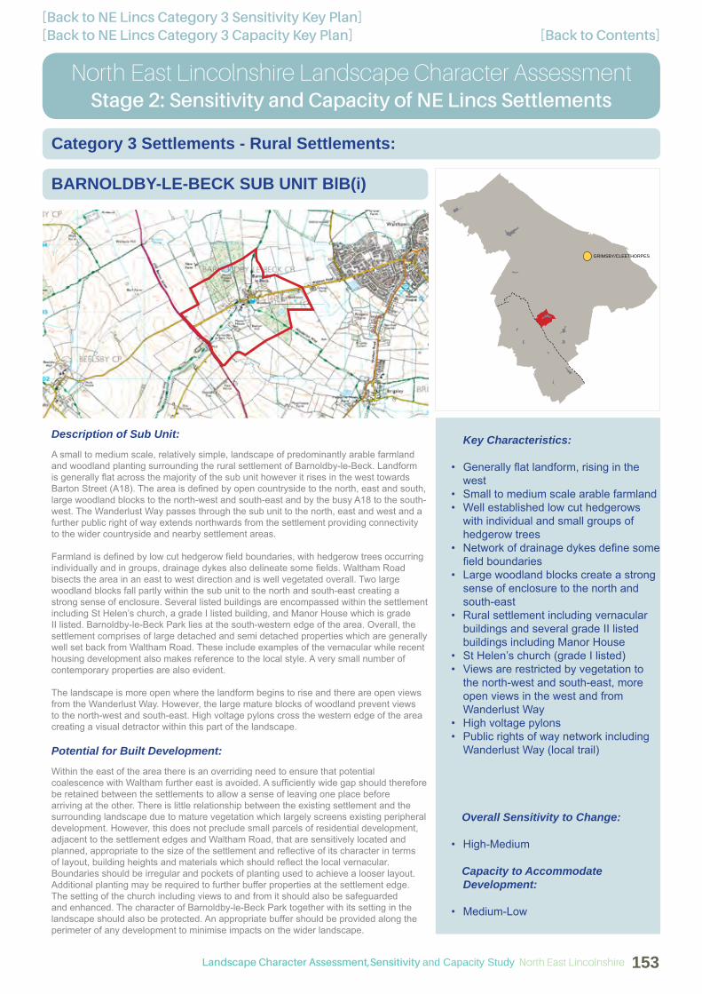
[Back to Contents][Back to NE Lincs Category 3 Capacity Key Plan][Back to NE Lincs Category 3 Sensitivity Key Plan]
GRIMSBY/CLEETHORPES
North East Lincolnshire Landscape Character AssessmentStage 2: Sensitivity and Capacity of NE Lincs Settlements
BARNOLDBY-LE-BECK SUB UNIT BlB(i)
Category 3 Settlements - Rural Settlements:
Key Characteristics:
• Generally fl at landform, rising in the west
• Small to medium scale arable farmland• Well established low cut hedgerows
with individual and small groups of hedgerow trees
• Network of drainage dykes defi ne some fi eld boundaries
• Large woodland blocks create a strong sense of enclosure to the north and south-east
• Rural settlement including vernacular buildings and several grade II listed buildings including Manor House
• St Helen’s church (grade I listed)• Views are restricted by vegetation to
the north-west and south-east, more open views in the west and from Wanderlust Way
• High voltage pylons• Public rights of way network including
Wanderlust Way (local trail)
Overall Sensitivity to Change:
• High-Medium
Capacity to Accommodate Development:
• Medium-Low
Description of Sub Unit:
A small to medium scale, relatively simple, landscape of predominantly arable farmland and woodland planting surrounding the rural settlement of Barnoldby-le-Beck. Landform is generally fl at across the majority of the sub unit however it rises in the west towards Barton Street (A18). The area is defi ned by open countryside to the north, east and south, large woodland blocks to the north-west and south-east and by the busy A18 to the south-west. The Wanderlust Way passes through the sub unit to the north, east and west and a further public right of way extends northwards from the settlement providing connectivity to the wider countryside and nearby settlement areas.
Farmland is defi ned by low cut hedgerow fi eld boundaries, with hedgerow trees occurring individually and in groups, drainage dykes also delineate some fi elds. Waltham Road bisects the area in an east to west direction and is well vegetated overall. Two large woodland blocks fall partly within the sub unit to the north and south-east creating a strong sense of enclosure. Several listed buildings are encompassed within the settlement including St Helen’s church, a grade I listed building, and Manor House which is grade II listed. Barnoldby-le-Beck Park lies at the south-western edge of the area. Overall, the settlement comprises of large detached and semi detached properties which are generally well set back from Waltham Road. These include examples of the vernacular while recent housing development also makes reference to the local style. A very small number of contemporary properties are also evident.
The landscape is more open where the landform begins to rise and there are open views from the Wanderlust Way. However, the large mature blocks of woodland prevent views to the north-west and south-east. High voltage pylons cross the western edge of the area creating a visual detractor within this part of the landscape.
Potential for Built Development:
Within the east of the area there is an overriding need to ensure that potential coalescence with Waltham further east is avoided. A suffi ciently wide gap should therefore be retained between the settlements to allow a sense of leaving one place before arriving at the other. There is little relationship between the existing settlement and the surrounding landscape due to mature vegetation which largely screens existing peripheral development. However, this does not preclude small parcels of residential development, adjacent to the settlement edges and Waltham Road, that are sensitively located and planned, appropriate to the size of the settlement and refl ective of its character in terms of layout, building heights and materials which should refl ect the local vernacular. Boundaries should be irregular and pockets of planting used to achieve a looser layout. Additional planting may be required to further buffer properties at the settlement edge. The setting of the church including views to and from it should also be safeguarded and enhanced. The character of Barnoldby-le-Beck Park together with its setting in the landscape should also be protected. An appropriate buffer should be provided along the perimeter of any development to minimise impacts on the wider landscape.
Landscape Character Assessment,Sensitivity and Capacity Study North East Lincolnshire 153

[Back to Contents][Back to NE Lincs Category 3 Capacity Key Plan][Back to NE Lincs Category 3 Sensitivity Key Plan]
North East Lincolnshire Landscape Character AssessmentStage 2: Sensitivity and Capacity of NE Lincs Settlements
BARNOLDBY-LE-BECK SUB UNIT BlB(i)
Category 3 Settlements - Rural Settlements:
Land Use/Management/Green Infrastructure Opportunities and Recommendations:
New development should be set within a framework of green infrastructure to include landscape planting and, where relevant, public open space appropriate to the scale of development. Existing hedgerows, hedgerow trees, woodland and vegetation containing the church and Manor House as well as vegetation adjacent to property boundaries should be retained as part of new green infrastructure proposals, enhanced and supplemented along with the provision of new suitable landscape buffers as appropriate. For example, additional planting may be required to further buffer properties at the settlement edge. The setting of the church including views to and from it should also be safeguarded and enhanced while the character of Barnoldby-le-Beck Park together with its setting in the landscape should also be protected. An appropriate buffer should be provided along the perimeter of any development to minimise impacts on the wider landscape. New green infrastructure should connect to the existing hedgerow network wherever feasible and SuDS should be designed to maximise biodiversity. Public rights of way, including the Wanderlust Way, should be incorporated within green corridors as part of future development and consideration should also be given to the provision of additional pedestrian, cycle and equestrian links into the existing network. Views across open countryside from the Wanderlust Way should be maintained.
There are also opportunities to:-
• Increase hedgerow and hedgerow tree cover;• Improve fi eld margins to create an ecologically diverse edge to the farmland;• Improve and enhance the existing woodland structure by appropriate management
together with woodland edge, understorey and ground fl ora planting to increase habitat diversity throughout and enhance the transition between the woodland and arable farmland;
• Enhance tree cover through small scale planting of broad leaved copses and woodland blocks while retaining the visually open character;
• Conserve the historic fi eld pattern, restore and reinforce primary hedgelines, including those along roadsides; and
• Refer to the North East Lincolnshire Landscape Character Assessment (2010) ‘local issues’ and implement wherever feasible.
North East Lincolnshire Landscape Character Assessment,Sensitivity and Capacity Study154

[Back to Contents][Back to NE Lincs Category 3 Capacity Key Plan][Back to NE Lincs Category 3 Sensitivity Key Plan]
GRIMSBY/CLEETHORPES
North East Lincolnshire Landscape Character AssessmentStage 2: Sensitivity and Capacity of NE Lincs Settlements
BEELSBY SUB UNIT Be(i)
Category 3 Settlements - Rural Settlements:
Key Characteristics:
• Shallow valley landform, rising to form plateaus in the east and west
• Medium scale arable farmland• Lincolnshire Wolds AONB• Well established hedgerows with
hedgerow trees, some gaps evident within hedgerows
• Mature tree belts partially enclose the settlement to the south
• Rural settlement including red brick vernacular buildings
• St Andrew’s church (grade II listed)• Views from the settlement are
restricted by vegetation and landform, open views from higher ground to the north-east and distant views towards Grimsby further east
• Public rights of way network including Wanderlust Way (local trail)
Overall Sensitivity to Change:
• High-Medium
Capacity to Accommodate Development:
• Low
Description of Sub Unit:
A medium scale arable landscape surrounding the rural settlement of Beesley which lies predominantly within a shallow valley with some larger properties and farmsteads located up on the higher valley slopes and plateaus at the top of the valley. Open countryside defi nes the north, east, south and west of the area which falls entirely within the Lincolnshire Wolds Area of Outstanding Natural Beauty. A network of local lanes cross the sub unit connecting to the surrounding settlement areas of Irby-upon-Humber to the north, Hatcliffe to the south and Croxby further south-west of the Borough boundary. The Wanderlust Way passes through the settlement as well as the overall area to the north-west and south-east, a further public right of way extends south-westwards. Together, these routes provide connectivity to the wider countryside and nearby settlement areas.
Farmland and local lanes are generally defi ned by well established hedgerows with hedgerow trees however some gaps in hedgerows are evident. Mature tree belts occur beyond the southern perimeter of the settlement and several properties within Beesley include mature tree planting. Red brick vernacular buildings occur within the main settlement some larger examples are Greenwood House and Beelsby Hall Farm which also includes several large modern agricultural buildings. St Andrew’s church, a grade II listed building, is located on higher ground within the settlement however it is somewhat obscured by modern residential development and ancillary buildings.
Views from the settlement are generally contained by landform and mature vegetation. However, there are some open views from higher ground across open countryside to the north-east and more distant views towards Grimsby further east.
Potential for Built Development:
Within the south-east of the area there is an overriding need to ensure that potential coalescence with Hatcliffe further south-east is avoided. A suffi ciently wide gap should therefore be retained between the settlements to allow a sense of leaving one place before arriving at the other. There is little relationship between the existing settlement and the surrounding landscape due to the screening effects of mature vegetation together with undulating landform which largely contains the settlement. However, this does not preclude small pockets of residential development, adjacent to the settlement edges and individual properties, that are sensitively located and planned, appropriate to the size of the settlement and refl ective of its character in terms of layout, building heights and materials which should refl ect the local vernacular. Boundaries should be irregular and pockets of planting used to achieve a looser layout. Additional planting may be required to further buffer the existing residential edge. An appropriate buffer should be provided along the perimeter of any development to minimise impacts on the wider landscape and the Lincolnshire Wolds AONB
Landscape Character Assessment,Sensitivity and Capacity Study North East Lincolnshire 155

[Back to Contents][Back to NE Lincs Category 3 Capacity Key Plan][Back to NE Lincs Category 3 Sensitivity Key Plan]
North East Lincolnshire Landscape Character AssessmentStage 2: Sensitivity and Capacity of NE Lincs Settlements
BEELSBY SUB UNIT Be(i)
Category 3 Settlements - Rural Settlements:
Land Use/Management/Green Infrastructure Opportunities and Recommendations:
New development should be set within a framework of green infrastructure to include structural landscape planting of native hedgerows and trees and, where relevant, public open space appropriate to the scale of development. Existing hedgerows and hedgerow trees as well as vegetation adjacent to existing property and farmstead boundaries should be retained as part of new green infrastructure proposals, enhanced and supplemented along with the provision of new suitable landscape buffers as appropriate. For example, additional planting may be required to further buffer the existing residential edge. An appropriate buffer should be provided along the perimeter of any development to minimise impacts on the wider landscape and the Lincolnshire Wolds AONB, the landscape character of which should be maintained in accordance with the aims and objectives of the current AONB Management Plan. New green infrastructure should incorporate existing vegetation and connect to the existing hedgerow network wherever feasible and SuDS should be designed to maximise biodiversity. Public rights of way, including the Wanderlust Way, should be incorporated within green corridors as part of future development and consideration should also be given to the provision of additional pedestrian, cycle and equestrian links into the existing network. Views across open countryside from the Wanderlust Way should be maintained.
There are also opportunities to:-
• Increase hedgerow tree cover;• Improve fi eld margins to create an ecologically diverse edge to the farmland;• Manage hedgerows to enhance the fi eld pattern by planting up gaps, allow hedges
to grow by reducing cut rotation to 3 yearly intervals for wildlife benefi ts;• Enhance tree cover through small scale planting of broad leaved copses and
woodland blocks while retaining the visually open character; • Conserve the historic fi eld pattern, restore and reinforce primary hedgelines,
including those along roadsides; • Refer to the current Lincolnshire Wolds AONB management objectives and
implement wherever feasible; and• Refer to the North East Lincolnshire Landscape Character Assessment (2010) ‘local
issues’ and implement wherever feasible.
North East Lincolnshire Landscape Character Assessment,Sensitivity and Capacity Study156

[Back to Contents][Back to NE Lincs Category 3 Capacity Key Plan][Back to NE Lincs Category 3 Sensitivity Key Plan]
GRIMSBY/CLEETHORPES
North East Lincolnshire Landscape Character AssessmentStage 2: Sensitivity and Capacity of NE Lincs Settlements
BRIGSLEY SUB UNIT Br(i)
Category 3 Settlements - Rural Settlements:
Key Characteristics:
• Predominantly fl at landform, rising gently north-west and south-east
• Small to medium scale agricultural farmland
• Well established hedgerows with hedgerow trees
• Waithe Beck• Rural settlement including red brick
vernacular buildings • St Helen’s church (grade II* listed)• Relatively enclosed views across much
of the area, more open views in the north
• Public rights of way network including Wanderlust Way (local trail)
Overall Sensitivity to Change:
• Medium
Capacity to Accommodate Development:
• Medium-Low
Description of Sub Unit:
A small to medium scale agricultural landscape comprising a mix of arable, pasture and meadow grassland surrounding the rural settlement of Brigsley. Landform is predominantly fl at, rising gently to the north-west and south-east. Open countryside defi nes the area to the north, east, south and west, beyond which lies the larger settlement of Waltham to the north and Ashby-cum-Fenby to the south. Waltham Road bisects the sub unit in a north to south direction and Waithe Lane connects Brigsley with the wider landscape and settlement areas to the east. The Wanderlust Way crosses the area in the north-west and south while a number of other public rights of way pass through the sub unit, some of which connect to the local trail. Together these routes provide connectivity to the wider countryside and nearby settlement areas.
Farmland and roads are generally defi ned by well established hedgerows with hedgerow trees, Waltham Road is particularly well vegetated overall and the Waithe Beck corridor crosses land in the south. The settlement encompasses a few examples of the local vernacular as well as St Helen’s church, a grade II* listed building, of which there are close range views from Waltham Road. Melbourne House Farm and Moor House on the periphery of Brigsley are grade II listed and include red brick vernacular buildings together with large modern agricultural buildings.
Views are generally enclosed within the sub unit due to mature roadside and fi eld boundary vegetation however there are more open views in the north.
Potential for Built Development:
Within the area there is an overriding need to ensure that potential coalescence with Waltham to the north and Ashby-cum-Fenby to the south is avoided. A suffi ciently wide gap should therefore be retained between the settlements to allow a sense of leaving one place before arriving at another. There is some relationship with the existing settlement edge in the north of the area where future development could logically be located, adjacent to the existing residential fringe and Waltham Road. Although, there is little relationship with the main core of the settlement where mature vegetation largely screens existing peripheral development. This however does not preclude small parcels of residential development, adjacent to the edges of the main settlement area, Waltham Road and Waithe Lane, that are sensitively located and planned, appropriate to the size of Brigsley and refl ective of its character in terms of layout, building heights and materials which should refl ect the local vernacular. Boundaries should be irregular and pockets of planting used to achieve a looser layout. Additional planting may be required to further buffer properties at the settlement edge. The setting of the church including views to and from it should also be safeguarded and enhanced. An appropriate buffer should be provided along the perimeter of any development to minimise impacts on the wider landscape.
Landscape Character Assessment,Sensitivity and Capacity Study North East Lincolnshire 157
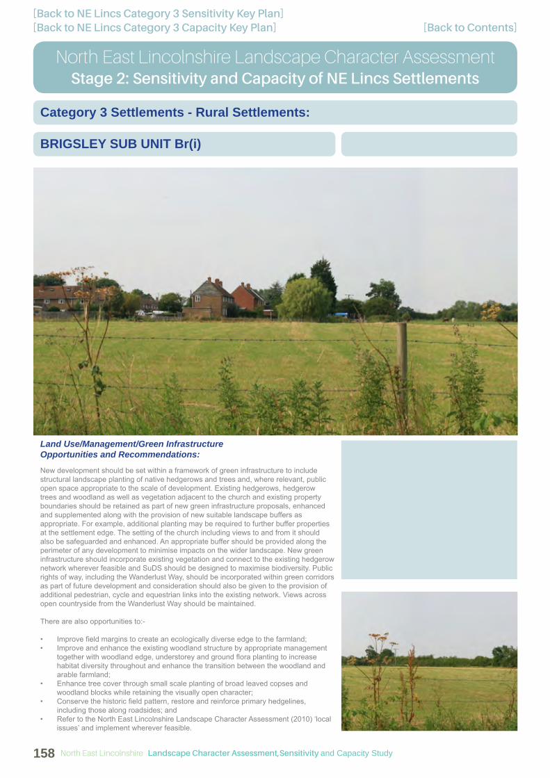
[Back to Contents][Back to NE Lincs Category 3 Capacity Key Plan][Back to NE Lincs Category 3 Sensitivity Key Plan]
North East Lincolnshire Landscape Character AssessmentStage 2: Sensitivity and Capacity of NE Lincs Settlements
BRIGSLEY SUB UNIT Br(i)
Category 3 Settlements - Rural Settlements:
Land Use/Management/Green Infrastructure Opportunities and Recommendations:
New development should be set within a framework of green infrastructure to include structural landscape planting of native hedgerows and trees and, where relevant, public open space appropriate to the scale of development. Existing hedgerows, hedgerow trees and woodland as well as vegetation adjacent to the church and existing property boundaries should be retained as part of new green infrastructure proposals, enhanced and supplemented along with the provision of new suitable landscape buffers as appropriate. For example, additional planting may be required to further buffer properties at the settlement edge. The setting of the church including views to and from it should also be safeguarded and enhanced. An appropriate buffer should be provided along the perimeter of any development to minimise impacts on the wider landscape. New green infrastructure should incorporate existing vegetation and connect to the existing hedgerow network wherever feasible and SuDS should be designed to maximise biodiversity. Public rights of way, including the Wanderlust Way, should be incorporated within green corridors as part of future development and consideration should also be given to the provision of additional pedestrian, cycle and equestrian links into the existing network. Views across open countryside from the Wanderlust Way should be maintained.
There are also opportunities to:-
• Improve fi eld margins to create an ecologically diverse edge to the farmland;• Improve and enhance the existing woodland structure by appropriate management
together with woodland edge, understorey and ground fl ora planting to increase habitat diversity throughout and enhance the transition between the woodland and arable farmland;
• Enhance tree cover through small scale planting of broad leaved copses and woodland blocks while retaining the visually open character;
• Conserve the historic fi eld pattern, restore and reinforce primary hedgelines, including those along roadsides; and
• Refer to the North East Lincolnshire Landscape Character Assessment (2010) ‘local issues’ and implement wherever feasible.
North East Lincolnshire Landscape Character Assessment,Sensitivity and Capacity Study158

[Back to Contents][Back to NE Lincs Category 3 Capacity Key Plan][Back to NE Lincs Category 3 Sensitivity Key Plan]
GRIMSBY/CLEETHORPES
North East Lincolnshire Landscape Character AssessmentStage 2: Sensitivity and Capacity of NE Lincs Settlements
EAST & WEST RAVENDALE SUB UNIT EWR(i)
Category 3 Settlements - Rural Settlements:
Key Characteristics:
• Generally undulating landform surrounding the settlement which lies within a shallow valley
• Medium scale agricultural farmland• Lincolnshire Wolds AONB• Well established hedgerows with
mature hedgerow trees along roadsides and fi eld boundaries,
• Woodland belts/plantations defi nes parts of the northern and eastern boundaries, mature trees at settlement edges
• Rural settlement including red brick vernacular buildings
• St Martin’s church, East Ravendale Hall and Primary School, (grade II listed)
• Views from the settlement are contained by landform and vegetation
• Public rights of way network including Wanderlust Way (local trail)
Overall Sensitivity to Change:
• High-Medium
Capacity to Accommodate Development:
• Low
Description of Sub Unit:
A medium scale agricultural landscape comprising a mix of arable and grazing farmland surrounding the rural settlement of East Ravendale and the neighbouring hamlet of West Ravendale which largely comprises of Priory Farm. East Ravendale lies within a shallow valley in the eastern part of the sub unit while West Ravendale is located further west within the valley. Undulating landform encompasses the settlements and open countryside defi nes the sub unit, which falls entirely within the Lincolnshire Wolds Area of Outstanding Natural Beauty, to the north, east, south and west. Grazing farmland tends to dominate land to the east of the B1203, which bisects the sub unit north to south, while arable farmland is more prominent in the west. The Wanderlust Way follows a local lane passing east to west through the area as well as directly through the settlement linking East and West Ravendale, two bridleways extend from the trail to the south and south-east. Together these routes provide connectivity to the wider countryside and nearby settlement areas.
Farmland and roadsides, including the Wanderlust Way and the B1203, are defi ned by well established continuous hedgerows with mature hedgerow trees. Woodland belts and plantations occur at the northern and eastern perimeters as well as at East Ravendale Hall. Mature trees occur at the settlement edges as well as at individual properties. The area encompasses St Martin’s church, East Ravendale Primary School and East Ravendale Hall which are all grade II listed. Vernacular properties are generally concentrated towards the eastern end of East Ravendale, both Priory Farm and Ravendale Farm include a complex of red brick vernacular buildings as well as large scale modern agricultural buildings.
Views are generally contained by landform and mature vegetation which often provides strong buffers along roadsides and fi eld boundaries. Low voltage pylons cross the north of the sub unit however are not considered to create a visual detractor within the landscape.
Potential for Built Development:
There is little relationship between the existing settlement and the surrounding landscape due to the screening effects of mature vegetation together with undulating landform which largely contains the settlement. However, this does not preclude small pockets of residential development within the valley bottom, adjacent to the settlement edges and individual properties, that are sensitively located and planned, appropriate to the size of the settlement and refl ective of its character in terms of layout, building heights and materials which should refl ect the local vernacular. Boundaries should be irregular and pockets of planting used to achieve a looser layout. Additional planting may be required to further buffer the existing residential edge. The setting of the church including views to and from it should also be safeguarded and enhanced. An appropriate buffer should be provided along the perimeter of any development to minimise impacts on the wider landscape and the Lincolnshire Wolds AONB.
Landscape Character Assessment,Sensitivity and Capacity Study North East Lincolnshire 159

[Back to Contents][Back to NE Lincs Category 3 Capacity Key Plan][Back to NE Lincs Category 3 Sensitivity Key Plan]
North East Lincolnshire Landscape Character AssessmentStage 2: Sensitivity and Capacity of NE Lincs Settlements
EAST & WEST RAVENDALE SUB UNIT EWR(i)
Category 3 Settlements - Rural Settlements:
Land Use/Management/Green Infrastructure Opportunities and Recommendations:
New development should be set within a framework of green infrastructure to include structural landscape planting of native hedgerows and trees and, where relevant, public open space appropriate to the scale of development. Existing hedgerows and hedgerow trees as well as vegetation adjacent to existing property boundaries, including East Ravendale Hall, should be retained as part of new green infrastructure proposals, enhanced and supplemented along with the provision of new suitable landscape buffers as appropriate. For example, additional planting may be required to further buffer the existing residential edge. The setting of the church including views to and from it should also be safeguarded and enhanced. An appropriate buffer should be provided along the perimeter of any development to minimise impacts on the wider landscape and the Lincolnshire Wolds AONB, the landscape character of which should be maintained in accordance with the aims and objectives of the current AONB Management Plan. New green infrastructure should incorporate existing vegetation and connect to the existing hedgerow network wherever feasible and SuDS should be designed to maximise biodiversity. Public rights of way, including the Wanderlust Way, should be incorporated within green corridors as part of future development and consideration should also be given to the provision of additional pedestrian, cycle and equestrian links into the existing network. Views across open countryside from the Wanderlust Way should be maintained.
There are also opportunities to:-
• Increase hedgerow tree cover;• Improve fi eld margins to create an ecologically diverse edge to the farmland;• Enhance tree cover through small scale planting of broad leaved copses and
woodland blocks while retaining the visually open character; • Conserve the historic fi eld pattern, restore and reinforce primary hedgelines,
including those along roadsides; • Refer to the current Lincolnshire Wolds AONB management objectives and
implement wherever feasible; and• Refer to the North East Lincolnshire Landscape Character Assessment (2010) ‘local
issues’ and implement wherever feasible.
North East Lincolnshire Landscape Character Assessment,Sensitivity and Capacity Study160

Description of Sub Unit:
A generally fl at and simple agricultural landscape of medium scale surrounding the settlement of Habrough. Arable farmland and areas of open grassland dominate land to the north, east and west of the settlement while horse and cattle grazing is prevalent across the majority of land to the south around Newsham Farm. The area is defi ned by open countryside to the north, south, east and west as well as the B1210 along the south-eastern edge. Several busy transport routes fragment the sub unit including the A180, the B1210 which separates the settlement from the rural landscape in the east, the Grimsby to Doncaster railway line as well as a network of local lanes. Public rights of way cross the area providing connectivity to wider countryside in the north, south and east.
Farmland and roadsides are defi ned by well established hedgerows, although few trees are evident along roadsides, and several intermittent mature hedgerow trees occur within internal fi eld boundaries. The area encompasses St Margaret’s church, a grade II listed building, which lies north-east of the main settlement. Vernacular buildings together with large modern agricultural buildings occur at The Grange, Newsham Farm and Pelham House. a small number of red brick vernacular buildings also occur along the B1210 within Habrough itself.
Views are generally open across the farmland, contained by mature roadside and fi eld boundary vegetation in places. High voltage pylons cross the south-western corner of the area creating a visual detractor within the landscape and low voltage pylons are evident within the north-eastern corner, however these are not considered to create a visual detractor.
Potential for Built Development:
There is some relationship with the existing settlement edge at the northern perimeter of the area where future development could logically be located, adjacent to the existing residential fringe and Station Road (B1210). There is potential for small parcels and pockets of residential development, adjacent to the edges of the main settlement area as well as individual and clustered properties, that are sensitively located and planned, appropriate to the size of Habrough, together with its dispersed peripheral development, and refl ective of its character in terms of layout, building heights and materials which should refl ect the local vernacular. Boundaries should be irregular and pockets of planting used to achieve a looser layout. Additional planting may be required to further buffer the existing residential edge. The setting of the church together with views to and from it should also be safeguarded and enhanced. An appropriate buffer should be provided along the perimeter of any development to minimise impacts on the wider landscape.
[Back to Contents][Back to NE Lincs Category 3 Capacity Key Plan][Back to NE Lincs Category 3 Sensitivity Key Plan]
GRIMSBY/CLEETHORPES
North East Lincolnshire Landscape Character AssessmentStage 2: Sensitivity and Capacity of NE Lincs Settlements
HABROUGH SUB UNIT Hab(i)
Category 3 Settlements - Rural Settlements:
Key Characteristics:
• Virtually fl at landform• Medium scale simple agricultural
landscape• Well established hedgerows with
hedgerow trees defi ne fi eld boundaries, hedgerows along roadsides are well established however few trees are present
• Red brick vernacular buildings • St Margaret’s church (grade II listed)• Generally open views• High voltage pylons• Busy transport corridors including the
A180, the B1210 and the Grimsby to Doncaster railway line
• Public rights of way network
Overall Sensitivity to Change:
• Medium-Low
Capacity to Accommodate Development:
• Medium-Low
Landscape Character Assessment,Sensitivity and Capacity Study North East Lincolnshire 161

[Back to Contents][Back to NE Lincs Category 3 Capacity Key Plan][Back to NE Lincs Category 3 Sensitivity Key Plan]
North East Lincolnshire Landscape Character AssessmentStage 2: Sensitivity and Capacity of NE Lincs Settlements
HABROUGH SUB UNIT Hab(i)
Category 3 Settlements - Rural Settlements:
Land Use/Management/Green Infrastructure Opportunities and Recommendations:
New development should be set within a framework of green infrastructure to include landscape planting and, where relevant, public open space appropriate to the scale of development. Existing hedgerows and hedgerow trees as well as vegetation adjacent to property boundaries should be retained as part of new green infrastructure proposals and should be enhanced and supplemented along with the provision of new suitable landscape buffers as appropriate. For example, additional planting may be required to further buffer the existing residential edge. The setting of the church together with views to and from it should also be safeguarded and enhanced. An appropriate buffer should be provided along the perimeter of any development to minimise impacts on the wider landscape. New green infrastructure should connect to the existing hedgerow network wherever feasible and SuDS should be designed to maximise biodiversity. Public rights of way should be incorporated within green corridors as part of future development and consideration should also be given to the provision of additional pedestrian, cycle and equestrian links into the existing network.
There are also opportunities to:-
• Increase hedgerow and hedgerow tree cover;• Improve fi eld margins to create an ecologically diverse edge to the farmland;• Enhance tree cover through small scale planting of broad leaved copses and
woodland blocks while retaining the visually open character; • Conserve the historic fi eld pattern, restore and reinforce primary hedgelines,
including those along roadsides; • Create an improved transition between the existing settlement edge and adjacent
rural area; and• Refer to the North East Lincolnshire Landscape Character Assessment (2010) ‘local
issues’ and implement wherever feasible.
North East Lincolnshire Landscape Character Assessment,Sensitivity and Capacity Study162

[Back to Contents][Back to NE Lincs Category 3 Capacity Key Plan][Back to NE Lincs Category 3 Sensitivity Key Plan]
GRIMSBY/CLEETHORPES
North East Lincolnshire Landscape Character AssessmentStage 2: Sensitivity and Capacity of NE Lincs Settlements
HATCLIFFE SUB UNIT Hat(i)
Category 3 Settlements - Rural Settlements:
Key Characteristics:
• Gently rounded hills surrounding the settlement which lies within a shallow valley
• Medium scale arable farmland• Lincolnshire Wolds AONB• Well established continuous hedgerows
with mature hedgerow trees• Woodland belts wrap around hillsides
in the north-west and south-east• Waithe Beck• Rural settlement including red brick
vernacular buildings • St Mary’s church (grade I listed)• Generally open views across the
surrounding AONB• Public rights of way network including
Wanderlust Way (local trail)
Overall Sensitivity to Change:
• High-Medium
Capacity to Accommodate Development:
• Low
Description of Sub Unit:
A medium scale, open arable landscape of gently rounded hills surrounding the rural settlement of Hatcliffe which lies within a shallow valley bottom. Open countryside defi nes the sub unit which falls entirely within the Lincolnshire Wolds Area of Outstanding Natural Beauty to the north, east, south and west. A local lane bisects the area in a south-east to north-west direction connecting directly with Beelsby to the north and East and West Ravendale to the south-east. The Wanderlust Way also follows this lane, diverting from it just north of the settlement in two directions; to the north and north-east. Further public rights of way cover the south-west of the area, a strong connectivity with the wider countryside is afforded overall.
Farmland is defi ned by well established and continuous hedgerows with mature hedgerow trees and woodland belts wrap around the hillsides within the north-west and south-east. The lane serving the settlement is well vegetated with mature hedgerows and hedgerow trees along with garden boundary planting. Waithe Beck passes through the sub unit in an east to west direction close to St Mary’s church, a grade I listed building, and two further grade II listed buildings are located close by. Both Hatcliffe Manor and Manor Farm Cottage, located south of the main settlement area, are red brick vernacular buildings.
Breaks in vegetation allow views across the surrounding AONB landscape of open undulating farmland.
Potential for Built Development:
Within the area there is an overriding need to ensure that potential coalescence with Beelsby to the north-west is avoided. A suffi ciently wide gap should therefore be retained between the settlements to allow a sense of leaving one place before arriving at the other. There is little relationship between the existing settlement and the surrounding landscape due to the screening effects of mature vegetation together with undulating landform which largely contains the settlement. However, this does not preclude small pockets of residential development within the valley bottom, adjacent to the settlement edge and individual properties, that are sensitively located and planned, appropriate to the size of the settlement and refl ective of its character in terms of layout, building heights and materials which should refl ect the local vernacular. Boundaries should be irregular and pockets of planting used to achieve a looser layout. Additional planting may be required to further buffer the existing residential edge as well as Manor Farm Cottage and Hatcliffe Manor. An appropriate buffer should be provided along the perimeter of any development to minimise impacts on the wider landscape and the Lincolnshire Wolds AONB.
Landscape Character Assessment,Sensitivity and Capacity Study North East Lincolnshire 163
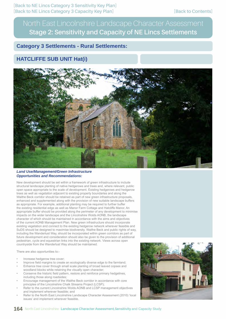
[Back to Contents][Back to NE Lincs Category 3 Capacity Key Plan][Back to NE Lincs Category 3 Sensitivity Key Plan]
North East Lincolnshire Landscape Character AssessmentStage 2: Sensitivity and Capacity of NE Lincs Settlements
HATCLIFFE SUB UNIT Hat(i)
Category 3 Settlements - Rural Settlements:
Land Use/Management/Green Infrastructure Opportunities and Recommendations:
New development should be set within a framework of green infrastructure to include structural landscape planting of native hedgerows and trees and, where relevant, public open space appropriate to the scale of development. Existing hedgerows and hedgerow trees as well as vegetation adjacent to existing property boundaries and along the Waithe Beck corridor should be retained as part of new green infrastructure proposals, enhanced and supplemented along with the provision of new suitable landscape buffers as appropriate. For example, additional planting may be required to further buffer the existing residential edge as well as Manor Farm Cottage and Hatcliffe Manor. An appropriate buffer should be provided along the perimeter of any development to minimise impacts on the wider landscape and the Lincolnshire Wolds AONB, the landscape character of which should be maintained in accordance with the aims and objectives of the current AONB Management Plan. New green infrastructure should incorporate existing vegetation and connect to the existing hedgerow network wherever feasible and SuDS should be designed to maximise biodiversity. Waithe Beck and public rights of way, including the Wanderlust Way, should be incorporated within green corridors as part of future development and consideration should also be given to the provision of additional pedestrian, cycle and equestrian links into the existing network. Views across open countryside from the Wanderlust Way should be maintained.
There are also opportunities to:-
• Increase hedgerow tree cover;• Improve fi eld margins to create an ecologically diverse edge to the farmland;• Enhance tree cover through small scale planting of broad leaved copses and
woodland blocks while retaining the visually open character; • Conserve the historic fi eld pattern, restore and reinforce primary hedgelines,
including those along roadsides; • Encourage management of the Waithe Beck corridor in accordance with core
principles of the Lincolnshire Chalk Streams Project (LCSP); • Refer to the current Lincolnshire Wolds AONB and LCSP management objectives
and implement wherever feasible; and• Refer to the North East Lincolnshire Landscape Character Assessment (2010) ‘local
issues’ and implement wherever feasible.
North East Lincolnshire Landscape Character Assessment,Sensitivity and Capacity Study164

[Back to Contents][Back to NE Lincs Category 3 Capacity Key Plan][Back to NE Lincs Category 3 Sensitivity Key Plan]
GRIMSBY/CLEETHORPES
North East Lincolnshire Landscape Character AssessmentStage 2: Sensitivity and Capacity of NE Lincs Settlements
HAWERBY-CUM-BEESBY SUB UNIT HcB(i)
Category 3 Settlements - Rural Settlements:
Key Characteristics:
• Landform gradually slopes from higher ground in the west to fl atter land in the east
• Medium scale arable farmland• Lincolnshire Wolds AONB• Generally well established hedgerows
with mature hedgerow trees, some gaps evident within hedgerows
• Woodland blocks adjacent to Hawerby Hall Farm and Wanderlust Way
• Rural landscape with isolated dwellings including red brick vernacular buildings
• St Margaret’s church (grade II* listed)• Hawerby Hall (grade II listed) is
prominent within a mature parkland setting
• Generally open views across the surrounding AONB
• Public rights of way network including Wanderlust Way (local trail)
Overall Sensitivity to Change:
• High-Medium
Capacity to Accommodate Development:
• Low
Description of Sub Unit:
A predominantly medium scale arable landscape rising some 50m from fl atter ground in the east to higher ground in the west. Open countryside defi nes the area, which falls entirely within the Lincolnshire Wolds Area of Outstanding Natural Beauty, to the north, west and south while Barton Street (A18) defi nes the southern edge. A local lane bisects the area in an east to west direction connecting directly with Wold Newton in the south-west and pedestrian access is provided across the area by the Wanderlust Way, which extends south-east to north-west, as well as a bridleway crossing in an east-west direction affording strong connectivity with the surrounding landscape.
Hedgerows along fi eld boundaries and the local lane are well established, although occasional gaps are evident, mature hedgerow trees and woodland occurs along part of the Wanderlust Way and envelopes Hawerby Hall Farm. Built development within the area is extremely limited including St Margaret’s church, a grade II* listed building, Hawerby Hall, a grade II listed building prominent on the sloping landform within a mature parkland setting, and Hawerby Hall Farm which encompasses a red brick vernacular building. Beesby is located further south of the sub unit contained by Beesby Wood and largely comprises of two isolated vernacular residential properties and a collection of farm buildings at Beesby Top. The historic site of the medieval village of Beesby, a designated Scheduled Monument, covers a fairly extensive tract of the landscape.
Although mature vegetation provides a degree of visual enclosure, the nature of the landform allows relatively open views across the area and wider AONB landscape.
Potential for Built Development:
There is little relationship between the existing isolated residential properties, and the surrounding landscape due to the screening effects of mature vegetation which contains the built development, with the exception of Hawerby Hall. Overall, there is little potential for future built development within the sub unit without compromising the sparsely settled character. However, this does not preclude individual or small pockets of residential development, adjacent to individual properties, that are sensitively located and planned, appropriate to the size of the settlement and refl ective of its character in terms of layout, building heights and materials which should refl ect the local vernacular. Boundaries should be irregular and pockets of planting used to achieve a looser layout. Additional planting may be required to further buffer the existing residential edge as well as Hawerby Hall and Hawerby Hall Farm. The setting of the church including views to and from it should be safeguarded and enhanced. The character of Hawerby Hall and its mature parkland setting within the landscape should also be protected. An appropriate buffer should be provided along the perimeter of any development to minimise impacts on the wider landscape and the Lincolnshire Wolds AONB.
Landscape Character Assessment,Sensitivity and Capacity Study North East Lincolnshire 165

[Back to Contents][Back to NE Lincs Category 3 Capacity Key Plan][Back to NE Lincs Category 3 Sensitivity Key Plan]
North East Lincolnshire Landscape Character AssessmentStage 2: Sensitivity and Capacity of NE Lincs Settlements
HAWERBY-CUM-BEESBY SUB UNIT HcB(i)
Category 3 Settlements - Rural Settlements:
Land Use/Management/Green Infrastructure Opportunities and Recommendations:
New development should be set within a framework of green infrastructure to include structural landscape planting of native hedgerows and trees and, where relevant, public open space appropriate to the scale of development. Existing hedgerows and hedgerow trees as well as vegetation adjacent to existing property boundaries should be retained as part of new green infrastructure proposals, enhanced and supplemented along with the provision of new suitable landscape buffers as appropriate. For example, additional planting may be required to further buffer the existing residential edge as well as Hawerby Hall and Hawerby Hall Farm. The setting of the church including views to and from it should be safeguarded and enhanced. The character of Hawerby Hall and its mature parkland setting within the landscape should also be protected. An appropriate buffer should be provided along the perimeter of any development to minimise impacts on the wider landscape and the Lincolnshire Wolds AONB, the landscape character of which should be maintained in accordance with the aims and objectives of the current AONB Management Plan. New green infrastructure should incorporate existing vegetation and connect to the existing hedgerow network wherever feasible and SuDS should be designed to maximise biodiversity. Public rights of way, including the Wanderlust Way, should be incorporated within green corridors as part of future development and consideration should also be given to the provision of additional pedestrian, cycle and equestrian links into the existing network. Views across open countryside from the Wanderlust Way should be maintained.
There are also opportunities to:-
• Increase hedgerow and hedgerow tree cover;• Improve fi eld margins to create an ecologically diverse edge to the farmland;• Manage hedgerows to enhance the fi eld pattern by planting up gaps, allow hedges
to grow by reducing cut rotation to 3 yearly intervals for wildlife benefi ts;• Enhance tree cover through small scale planting of broad leaved copses and
woodland blocks while retaining the visually open character; • Conserve the historic fi eld pattern, restore and reinforce primary hedgelines,
including those along roadsides;• Refer to the current Lincolnshire Wolds AONB management objectives and
implement wherever feasible; and• Refer to the North East Lincolnshire Landscape Character Assessment (2010) ‘local
issues’ and implement wherever feasible.
North East Lincolnshire Landscape Character Assessment,Sensitivity and Capacity Study166

[Back to Contents][Back to NE Lincs Category 3 Capacity Key Plan][Back to NE Lincs Category 3 Sensitivity Key Plan]
GRIMSBY/CLEETHORPES
North East Lincolnshire Landscape Character AssessmentStage 2: Sensitivity and Capacity of NE Lincs Settlements
IRBY-UPON-HUMBER SUB UNIT IuH(i)
Category 3 Settlements - Rural Settlements:
Key Characteristics:
• Gently sloping landform, rising to the north-west and west
• Medium to large scale arable farmland• Lincolnshire Wolds AONB extends
across the south and east• Well established continuous hedgerows
with occasional hedgerow trees along some roadsides, others are completely open with no planting and internal hedgerows are limited
• Rural settlement with a dispersed character
• Several large vernacular buildings including red brick examples particularly within farmsteads
• St Andrew’s church (grade I listed)• Views are generally open and include
distant north-easterly views towards Grimsby and Immingham Docks from higher ground
• Public rights of way network
Overall Sensitivity to Change:
• High-Medium
Capacity to Accommodate Development:
• Low
Description of Sub Unit:
A medium to large scale, predominantly arable landscape of open and simple character which slopes gently to the north and east surrounding the rural settlement of Irby-upon-Humber. Open countryside defi nes the sub unit to the north, east, south and west, the southern and eastern parts of the sub unit (south of Old Main Road) fall within the Lincolnshire Wolds Area of Outstanding Natural Beauty. The area is bisected north-east to west by Grimsby Road (A46), this bypasses the Old Main Road which serves the settlement area while Trunkass Lane provides a link to Beelsby further south. Public rights of way are concentrated to the northern part of the area however part of a bridleway defi nes the south-eastern corner and connectivity to the wider countryside is good overall.
Grimsby Road is particularly well vegetated, where roadside hedgerows occur they are generally well established and continuous with few intermittent hedgerow trees, however some roadsides are not planted and have an open character. There is no woodland cover and internal fi eld boundaries are limited with arable fi elds tending to be open and. The settlement has a dispersed character overall with a mature tree setting at its periphery. It encompasses St Andrew’s church, a grade I listed building, together with several large, prominent, vernacular residential properties including two further grade II listings. Complexes of red brick vernacular buildings occur at Irby Dales Farm, which includes a grade II listed building, and Manor Farm.
Views are generally open due to the more elevated and sloping landform. There are open north-easterly views towards Immingham and Grimsby Docks as well as southerly views towards an area of ancient woodland.
Potential for Built Development:
Within the east of the area there is an overriding need to ensure that potential coalescence with Laceby to the north-east is avoided. A suffi ciently wide gap should therefore be retained between the settlements to allow a sense of leaving one place before arriving at the other. There is little relationship between the existing settlement and the surrounding landscape due to the screening effects of mature vegetation which largely contains the settlement. However, this does not preclude small pockets of residential development, adjacent to the settlement edge, Old Main Road and individual properties, that are sensitively located and planned, appropriate to the size of the settlement and refl ective of its character in terms of layout, building heights and materials which should refl ect the local vernacular. Boundaries should be irregular and pockets of planting used to achieve a looser layout. Additional planting may be required to further buffer the existing residential edge. The setting of the church including views to and from it should also be safeguarded and enhanced. An appropriate buffer should be provided along the perimeter of any development to minimise impacts on the wider landscape and the Lincolnshire Wolds AONB.
Landscape Character Assessment,Sensitivity and Capacity Study North East Lincolnshire 167

[Back to Contents][Back to NE Lincs Category 3 Capacity Key Plan][Back to NE Lincs Category 3 Sensitivity Key Plan]
North East Lincolnshire Landscape Character AssessmentStage 2: Sensitivity and Capacity of NE Lincs Settlements
IRBY-UPON-HUMBER SUB UNIT IuH(i)
Category 3 Settlements - Rural Settlements:
Land Use/Management/Green Infrastructure Opportunities and Recommendations:
New development should be set within a framework of green infrastructure to include structural landscape planting of native hedgerows and trees and, where relevant, public open space appropriate to the scale of development. Existing hedgerows and hedgerow trees as well as vegetation adjacent to existing property boundaries should be retained as part of new green infrastructure proposals, enhanced and supplemented along with the provision of new suitable landscape buffers as appropriate. For example, additional planting may be required to further buffer the existing residential edge. The setting of the church including views to and from it should also be safeguarded and enhanced. An appropriate buffer should be provided along the perimeter of any development to minimise impacts on the wider landscape and the Lincolnshire Wolds AONB, the landscape character of which should be maintained in accordance with the aims and objectives of the current AONB Management Plan. New green infrastructure should incorporate existing vegetation and connect to the existing hedgerow network wherever feasible and SuDS should be designed to maximise biodiversity. Public rights of way should be incorporated within green corridors as part of future development and consideration should also be given to the provision of additional pedestrian, cycle and equestrian links into the existing network. Views across open countryside should be maintained.
There are also opportunities to:-
• Increase hedgerow and hedgerow tree cover;• Improve fi eld margins to create an ecologically diverse edge to the farmland;• Enhance tree cover through small scale planting of broad leaved copses and
woodland blocks while retaining the visually open character; • Conserve the historic fi eld pattern, restore and reinforce primary hedgelines,
including those along roadsides; • Refer to the current Lincolnshire Wolds AONB management objectives and
implement wherever feasible; and• Refer to the North East Lincolnshire Landscape Character Assessment (2010) ‘local
issues’ and implement wherever feasible.
North East Lincolnshire Landscape Character Assessment,Sensitivity and Capacity Study168

[Back to Contents][Back to NE Lincs Category 3 Capacity Key Plan][Back to NE Lincs Category 3 Sensitivity Key Plan]
GRIMSBY/CLEETHORPES
North East Lincolnshire Landscape Character AssessmentStage 2: Sensitivity and Capacity of NE Lincs Settlements
STALLINGBOROUGH SUB UNIT S(i)
Category 3 Settlements - Rural Settlements:
Key Characteristics:
• Virtually fl at landform• Medium scale simple arable landscape• Well established hedgerows along
roadsides, internal fi eld boundaries are low cut and often gappy where they occur
• Network of drainage dykes, including Middle Drain, defi ning some fi eld boundaries
• Red brick vernacular buildings generally associated with farmsteads
• St Peter and St Paul’s church (grade II* listed) and Stallingborough Medieval Settlement Scheduled Monument
• Generally open views• High voltage pylons• Busy transport corridors including the
A180, the B1210 and the Grimsby to Doncaster railway line
• Public rights of way network
Overall Sensitivity to Change:
• Medium
Capacity to Accommodate Development:
• Medium-Low
Description of Sub Unit:
A generally fl at and simple arable landscape of medium scale surrounding the settlement of Stallingborough, land to the north-west is particularly open and simple in character. The area is defi ned by open countryside to the north, south, east and west and by the A180 along the north-western edge. Several busy transport routes fragment the sub unit, including the A180, the B1210 as well as the Grimsby to Doncaster railway line, all of which cross the area east to west. Station Road bisects the area north-east to south-west serving the settlement itself and a future highway link is proposed along the western edge of the area connecting to the roundabout south-east of the village. Public rights of way criss cross the area providing connectivity to the wider countryside in all directions.
Hedgerows along roadsides are generally well established while internal fi eld boundary hedgerows are low and often gappy or absent altogether, some fi elds are defi ned by a network of drainage dykes, including Middle Drain. Overall there is little tree cover and no woodland is present within the area. The sub unit encompasses St Peter and St Paul’s church, a grade II* listed building, which lies at the western extremity of the village, encompassed by the historic site of Stallingborough Medieval Settlement, a designated Scheduled Monument, where ridge and furrow is evident. The majority of the village comprises of mid to late 20th century development however Manor Farm and Pidgeon Cote Farm, which form part of the main settlement, and Low Farm, which is isolated from the village, include complexes of red brick vernacular buildings together with large modern farm buildings. Eleanor House is also detached from the village and is a further example of local vernacular, three further grade II listings are encompassed within the settlement.
Views are generally open across the farmland, some enclosure is provided by mature vegetation along transport corridors. High voltage pylons cross the north-western corner of the area creating a visual detractor within the landscape.
Potential for Built Development:
Within the east of the area there is an overriding need to ensure that potential coalescence with Healing to the south-east is avoided. A suffi ciently wide gap should therefore be retained between the settlements to allow a sense of leaving one place before arriving at the other. There is some relationship with the existing settlement edge along the south-western perimeter of the area and a relatively strong relationship with the southern and eastern perimeter where future development could logically be located, adjacent to the existing residential fringe and Healing Road. There is potential for small parcels of residential development, adjacent to the settlement edges, that are sensitively located and planned, appropriate to the size of Stallingborough, and refl ective of its character in terms of layout, building heights and materials which should refl ect the local vernacular. Boundaries should be irregular and pockets of planting used to achieve a looser layout. There are plans to implement a new highway link along the western edge of the sub unit which is is proposed to connect to the roundabout south-east of the village, this should be considered alongside any future development within the area. Additional planting may be required to further buffer the existing residential edge and structural landscaping will be necessary to screen the proposed future highway route. The setting of the church and Scheduled Monument including views to and from these features should also be safeguarded and enhanced. An appropriate buffer should be provided along the perimeter of any development to minimise impacts on the wider landscape.
Landscape Character Assessment,Sensitivity and Capacity Study North East Lincolnshire 169

[Back to Contents][Back to NE Lincs Category 3 Capacity Key Plan][Back to NE Lincs Category 3 Sensitivity Key Plan]
North East Lincolnshire Landscape Character AssessmentStage 2: Sensitivity and Capacity of NE Lincs Settlements
STALLINGBOROUGH SUB UNIT S(i)
Category 3 Settlements - Rural Settlements:
Land Use/Management/Green Infrastructure Opportunities and Recommendations:
New development should be set within a framework of green infrastructure to include landscape planting and, where relevant, public open space appropriate to the scale of development. Existing hedgerows, hedgerow trees and woodland as well as vegetation adjacent to property boundaries should be retained as part of new green infrastructure proposals and should be enhanced and supplemented along with the provision of new suitable landscape buffers as appropriate. For example, additional planting may be required to further buffer the existing residential edge and structural landscaping will be necessary to screen the proposed future highway route. The setting of the church and Scheduled Monument including views to and from these features should also be safeguarded and enhanced. An appropriate buffer should be provided along the perimeter of any development to minimise impacts on the wider landscape. New green infrastructure should connect to the existing hedgerow network wherever feasible and SuDS should be designed to maximise biodiversity. Public rights of way should be incorporated within green corridors as part of future development and consideration should also be given to the provision of additional pedestrian, cycle and equestrian links into the existing network.
There are also opportunities to:-
• Increase hedgerow and hedgerow tree cover;• Improve fi eld margins to create an ecologically diverse edge to the farmland;• Manage hedgerows to enhance the fi eld pattern by planting up gaps, allow hedges
to grow by reducing cut rotation to 3 yearly intervals for wildlife benefi ts;• Raise public awareness of Stallingborough Medieval Settlement Scheduled
Monument through interpretation for example;• Enhance tree cover through small scale planting of broad leaved copses and
woodland blocks while retaining the visually open character; • Conserve the historic fi eld pattern, restore and reinforce primary hedgelines,
including those along roadsides; • Create an improved transition between the existing settlement edge and adjacent
rural area; and• Refer to the North East Lincolnshire Landscape Character Assessment (2010) ‘local
issues’ and implement wherever feasible.
North East Lincolnshire Landscape Character Assessment,Sensitivity and Capacity Study170

[Back to Contents][Back to NE Lincs Category 3 Capacity Key Plan][Back to NE Lincs Category 3 Sensitivity Key Plan]
GRIMSBY/CLEETHORPES
North East Lincolnshire Landscape Character AssessmentStage 2: Sensitivity and Capacity of NE Lincs Settlements
WOLD NEWTON SUB UNIT WN(i)
Category 3 Settlements - Rural Settlements:
Key Characteristics:
• Gently rounded hills surround the settlement which lies within a shallow valley
• Medium scale agricultural farmland• Lincolnshire Wolds AONB• Well established continuous hedgerows
with mature hedgerow trees• Woodland encompasses some
buildings and aligns sections of rights of way
• Rural settlement including red brick vernacular buildings
• All Saints church (grade II listed)• Views are generally restricted by
mature vegetation, some views across the surrounding AONB from higher ground
• Public rights of way network including Wanderlust Way (local trail)
Overall Sensitivity to Change:
• High-Medium
Capacity to Accommodate Development:
• Low
Description of Sub Unit:
The rural settlement of Wold Newton lies within a shallow valley and is surrounded by medium scale agricultural farmland which rises to the east and west to form gently rounded hills. The landscape is dominated by arable farmland in the north and grazed farmland in the south. Open countryside defi nes the sub unit, which falls entirely within the Lincolnshire Wolds Area of Outstanding Natural Beauty to the north, east, south and west. A local lane bisects the area in a north to south direction connecting directly with East Ravendale to the north. This is also followed by the Wanderlust Way. This trail diverts from the lane close to North Farm and South Farm and continues through open fi elds further north and south-east. Other public rights of way cross the area in the east and west affording strong connectivity with the wider countryside overall.
Hedgerows along fi eld boundaries and the local lane are well established and continuous with mature hedgerow trees and woodland wraps around North Farm and All Saints church (grade II listed) extending in a westerly direction alongside the bridleway. Woodland planting also encompasses The Grange (grade II listed) in the south, together with a section of the Wanderlust Way trail. The settlement contains vernacular buildings including two further grade II listings. Both North Farm and South Farm include complexes of red brick vernacular buildings.
Views are generally enclosed due to the high degree of mature vegetation however there are some views across the surrounding landscape and AONB from public rights of way on the valley side slopes.
Potential for Built Development:
There is little relationship between the existing settlement and the surrounding landscape due to the screening effects of mature vegetation which largely contains the settlement. However, this does not preclude small pockets of residential development within the valley bottom, adjacent to the settlement edge and individual properties, that are sensitively located and planned, appropriate to the size of the settlement and refl ective of its character in terms of layout, building heights and materials which should refl ect the local vernacular. Boundaries should be irregular and pockets of planting used to achieve a looser layout. Additional planting may be required to further buffer the existing residential edge. The setting of the church including views to and from it should also be safeguarded and enhanced. An appropriate buffer should be provided along the perimeter of any development to minimise impacts on the wider landscape and the Lincolnshire Wolds AONB.
Landscape Character Assessment,Sensitivity and Capacity Study North East Lincolnshire 171

[Back to Contents][Back to NE Lincs Category 3 Capacity Key Plan][Back to NE Lincs Category 3 Sensitivity Key Plan]
North East Lincolnshire Landscape Character AssessmentStage 2: Sensitivity and Capacity of NE Lincs Settlements
WOLD NEWTON SUB UNIT WN(i)
Category 3 Settlements - Rural Settlements:
Land Use/Management/Green Infrastructure Opportunities and Recommendations:
New development should be set within a framework of green infrastructure to include structural landscape planting of native hedgerows and trees and, where relevant, public open space appropriate to the scale of development. Existing hedgerows, hedgerow trees and woodland as well as vegetation adjacent to existing property boundaries should be retained as part of new green infrastructure proposals, enhanced and supplemented along with the provision of new suitable landscape buffers as appropriate. For example, additional planting may be required to further buffer the existing residential edge. The setting of the church including views to and from it should also be safeguarded and enhanced. An appropriate buffer should be provided along the perimeter of any development to minimise impacts on the wider landscape and the Lincolnshire Wolds AONB, the landscape character of which should be maintained in accordance with the aims and objectives of the current AONB Management Plan. New green infrastructure should incorporate existing vegetation and connect to the existing hedgerow network wherever feasible and SuDS should be designed to maximise biodiversity. Public rights of way, including the Wanderlust Way, should be incorporated within green corridors as part of future development and consideration should also be given to the provision of additional pedestrian, cycle and equestrian links into the existing network. Views across open countryside from the Wanderlust Way should be maintained.
There are also opportunities to:-
• Increase hedgerow tree cover;• Improve fi eld margins to create an ecologically diverse edge to the farmland;• Improve and enhance the existing woodland structure by appropriate management
together with woodland edge, understorey and ground fl ora planting to increase habitat diversity throughout and enhance the transition between the woodland and arable farmland;
• Enhance tree cover through small scale planting of broad leaved copses and woodland blocks while retaining the visually open character;
• Conserve the historic fi eld pattern, restore and reinforce primary hedgelines, including those along roadsides;
• Refer to the current Lincolnshire Wolds AONB management objectives and implement wherever feasible; and
• Refer to the North East Lincolnshire Landscape Character Assessment (2010) ‘local issues’ and implement wherever feasible.
North East Lincolnshire Landscape Character Assessment,Sensitivity and Capacity Study172