Embed Size (px)
Citation preview
New M5 WestConnex Urban Design Urban Design77
5.7 St Peters interchange and local street upgrades5.7.1 St Peters InterchangeThe St Peters interchange is located within theAlexandriaLandfillsite,connectingwiththe local road network at the intersection of Campbell and Euston Roads. The site is bound by Canal Road in the west, Burrows Road in the south, Princes Highway in the north and Campbell Road in the east. The St Peters interchange is a key connection in the overall Westconnex journey. With the New M5 tunnel entry/exit point at the southern reaches of the St Peters Interchange, connections would be made to the surrounding local road network as well as the future M4-M5 Link and Sydney Gateway. These two future links would provide regional connections to Sydney Airport and western Sydney as well as the remainder of Sydney’s orbital road network.
To achieve a lasting and cohesive urban design strategy for the overall interchange, the site requires a design solution that would unify and shape the different stages of the project, including the New M5, and the future Sydney Gateway and M4-M5 link.
The St Peters interchange consists of the motorway control centre, ventilation facility, distributionsubstation,firepumproomsand deluge tanks and the interchange road network. The ventilation facility and
associated service buildings are located above the tunnel portals, at the corner of Canal Road and Princes Highway (the St Peters motorway operations complex - MOC4). The facility would be located directly over the exit ramp cut and cover structure along with an electrical distributionfacility,firepumproomsandadjacent deluge tanks. Access to these facilities is provided from Canal Road. The motorway control centre (MOC5) is located at the corner of Burrows Road and Campbell Road.
In developing the design, a strategy has been proposed for the overall interchange, focusing on the following objectives:
• Return surplus lands to the community as public open space.
• Provide an extensive green volume of vegetation to compete with and soften the scale of the proposed multi-level interchange, creating an ‘urban forest’
• Promote the use of a tall, established tree canopy cover to not only soften the scale of the proposed infrastructure, but also provide a counterpoint and extension of the green open space of Sydney Park
• Built form designed to enhance the existing street character.
The design allows for future stages of the interchange to adopt similar approaches to materials and detailing to achieve overall project cohesion and an integrated ‘whole of project outcome’. The landscape approach in this zone is essentially to create ‘green volume’ and remediate the formerlandfillsitebycreatingan‘urbanforest’, capable of competing with the scale of the proposed interchange.
Large areas of new tree planting would be incorporated on both sides of the New M5 ramps and above the portals to present a continuous green canopy and create a sense of green immersion for the motorist upon entry or exit from the tunnel. Landscape treatments surrounding the Canal Road MOC4 would focus on creating adefinedstreetedgewithstreettreeplanting, and feature Fig Tree plantings to offer increased ‘green volume’ and help defineasenseoflandscapecharacterforthesite.Thesefigswouldalsoprovidevaluable shade for park users.
New M5 WestConnex Urban Design Urban Design78
5.7.2 Local StreetsThe overall design intent is to create a series of tree lined local streets that offer amenity for local residents, create a high quality environment for pedestrians and cyclists, and integrate the local streetscape with adjacent open space and parkland, particularly in the vicinity of Sydney Park.
The design incorporates a series of feature pedestrian and cycleway bridges that would increase connectivity for and allow integration of the open space proposed for the St Peters interchange. Tree and landscape plantings would be designed to match City of Sydney, Botany Bay and Marrickville Council guidelines. Vegetation and tree plantings would be used to create a sense of visual separation for pedestrians and cyclists from the road edge.
The design of wall structures would be refinedandelegant,withoutunnecessaryfussiness or embellishment, with landscape treatments used to soften the appearance of retaining walls and other structures.
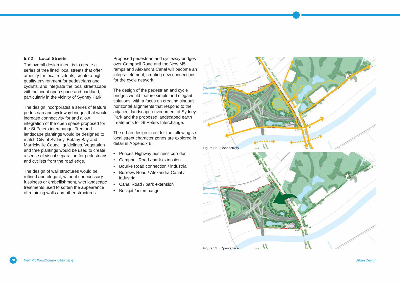
Proposed pedestrian and cycleway bridges over Campbell Road and the New M5 ramps and Alexandra Canal will become an integral element, creating new connections for the cycle network.
The design of the pedestrian and cycle bridges would feature simple and elegant solutions, with a focus on creating sinuous horizontal alignments that respond to the adjacent landscape environment of Sydney Park and the proposed landscaped earth treatments for St Peters Interchange.
The urban design intent for the following six local street character zones are explored in detail in Appendix B:
• Princes Highway business corridor• Campbell Road / park extension• Bourke Road connection / industrial• Burrows Road / Alexandra Canal /
industrial• Canal Road / park extension• Brickpit / interchange.
Figure 52 Connectivity
Figure 53 Open space
New M5 WestConnex Urban Design Urban Design79
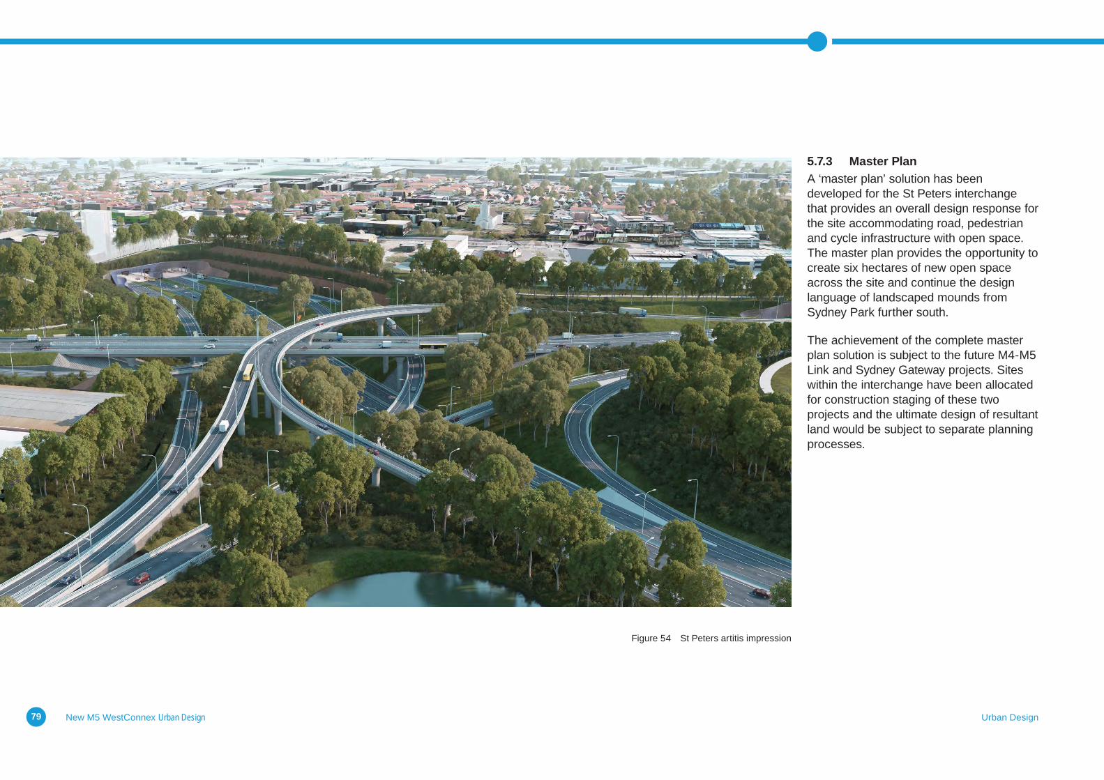
5.7.3 Master PlanA ‘master plan’ solution has been developed for the St Peters interchange that provides an overall design response for the site accommodating road, pedestrian and cycle infrastructure with open space. The master plan provides the opportunity to create six hectares of new open space across the site and continue the design language of landscaped mounds from Sydney Park further south.
The achievement of the complete master plan solution is subject to the future M4-M5 Link and Sydney Gateway projects. Sites within the interchange have been allocated for construction staging of these two projects and the ultimate design of resultant land would be subject to separate planning processes.
Figure 54 St Peters artitis impression
New M5 WestConnex Urban Design Urban Design80
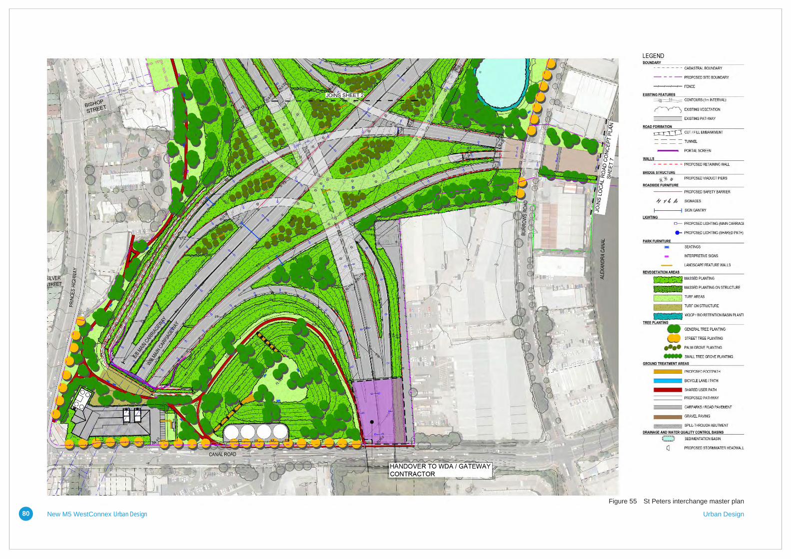
Figure 55 St Peters interchange master plan
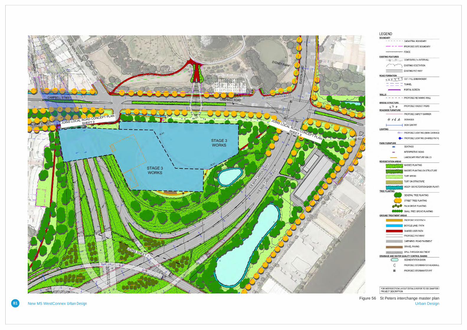
New M5 WestConnex Urban Design Urban Design81Figure 56 St Peters interchange master plan
New M5 WestConnex Urban Design Urban Design82
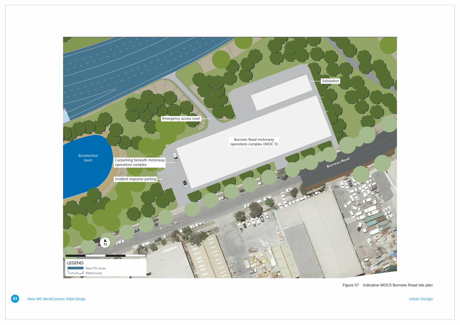
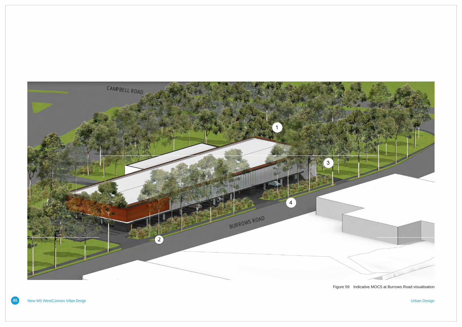
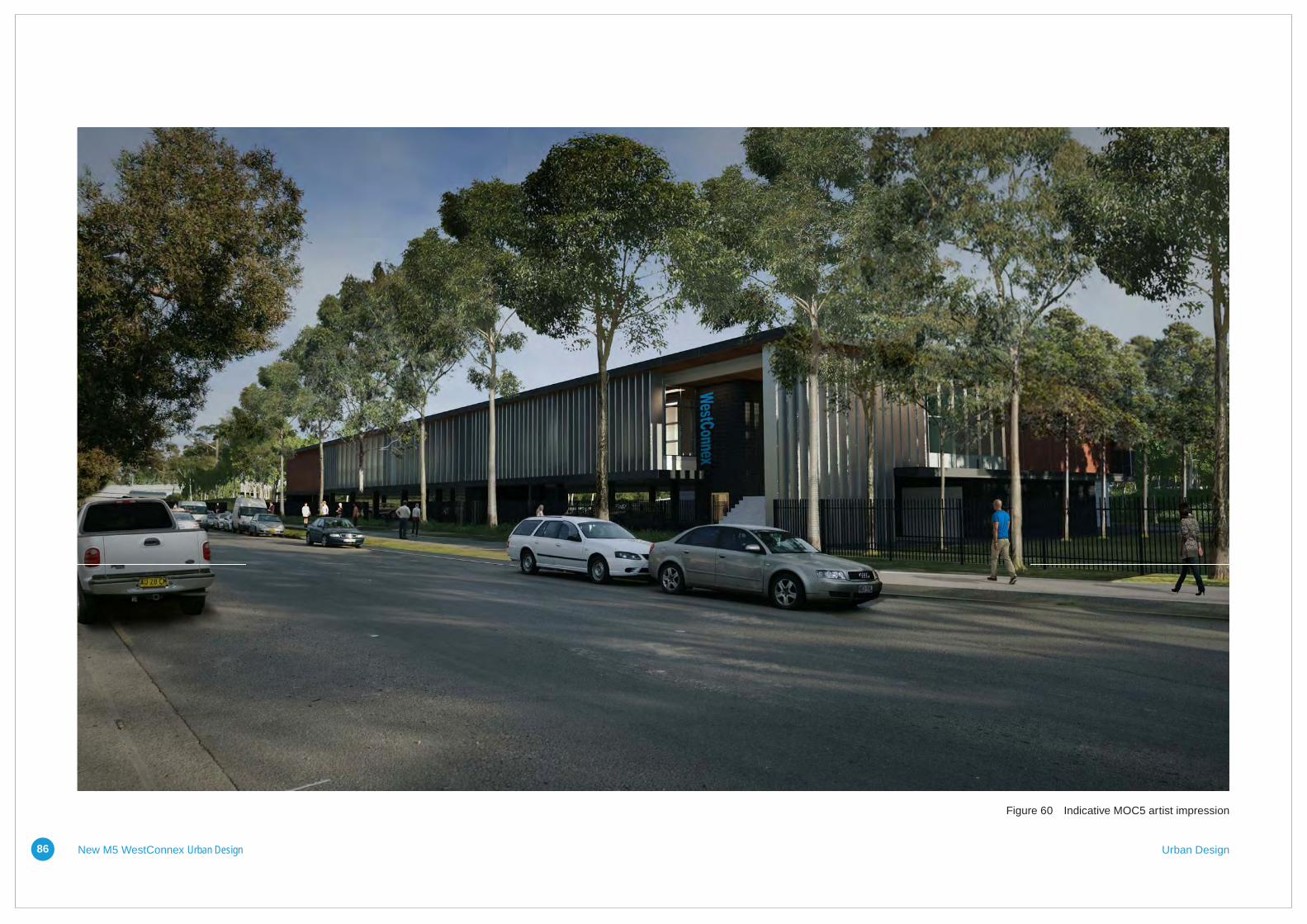
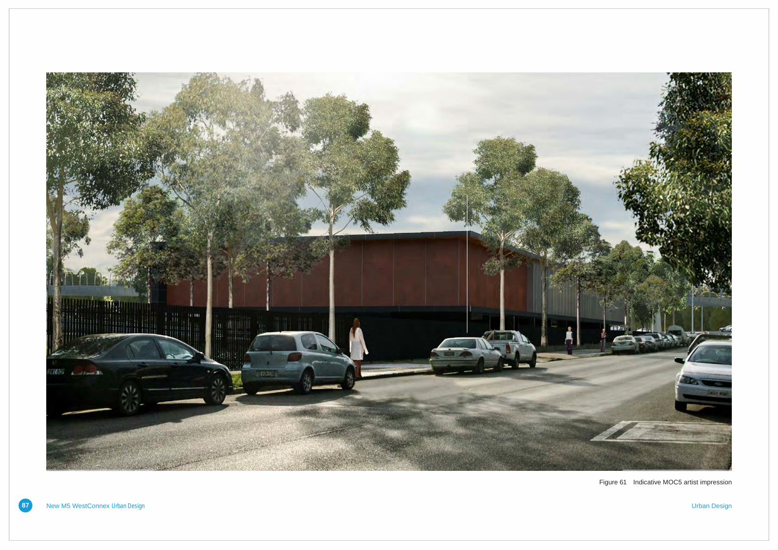
5.7.4 Burrows Road Motorway Operations Complex The Burrows Road Operations Complex (MOC5) would be the central building for all communications and control of the project’s operational management control systems (OCMS). The motorway control centre would be staffed 24 hours per day, seven days per week, and would require around 26 full time equivalent staff. Located on the corner of Campbell and Burrows Roads the ground level accommodates an open carpark, bike storage and waste facilities. The carpark is softened by a large landscaped buffer between the kerb and building. Slender concrete columns support the upper level allowing views out from beneath the building and raise it above floodeventlevels.Theupperlevelhousesreception,openplanoffices,enclosedoffices,breakoutspace,alunchroomandassociated staff amenities.
Design intentThe intent for the design of the motorway control centre is to blend with the surrounding light industrial land use, whilst maintaining the New M5 identity. It is a two level building with an open carpark below the main functional spaces. The main address, vehicle and pedestrian access is from Burrows Road. A substation building is sited to the rear of the main structure.
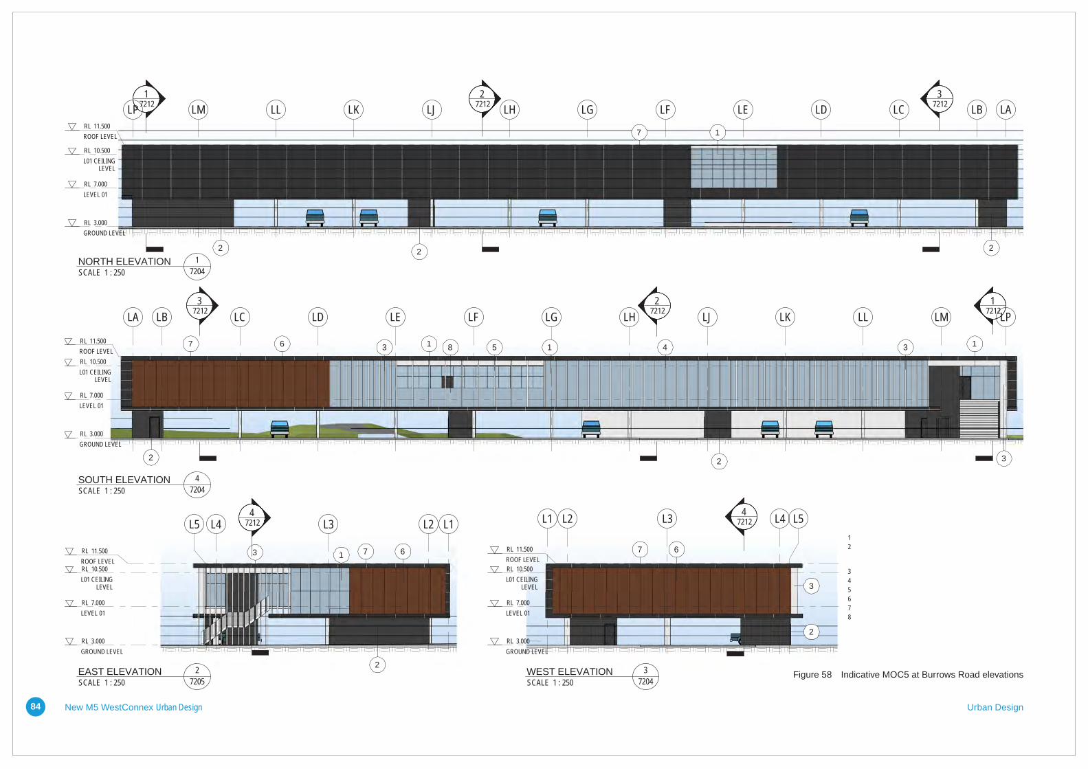
A long span roof supported from the northern and southern walls provides near limitlessflexibilityfortheinteriors.Uninterrupted power supply and electrical equipment rooms are located in a consolidatedblocktothenorthofthefloorplate.
The horizontal nature of the building is accentuatedbytheexpressionofthefloorand roof lines on the south elevation to BurrowsRoad.Thefloorandrooflinesreturn around the eastern and western ends and fold vertically down the south elevation to meet and form a continuous ‘C’ shaped loop. A series of vertical louvres punctuate the Burrows Road façade and return to the east to form a screen to the double height entry space.
Materials, colours and finishesClad in composite aluminium panels, the southern elevation of the control centre wraps up and over the building to form a ‘casing’ into which the building is inserted. The motorway control rooms are clad in corten steel panels, emphasising its secure nature.Theofficeandbreakoutspacesareenclosed with clear glass to provide natural light to the working environments.
The long linear nature of the building is articulated with vertical louvres spaced at different intervals along the Burrows Road façade. The spacing responds to the private or public nature of the spaces within, and provides a shifting rhythm. Egress stairs and plant spaces at the ground level are exposed smooth faced concrete block, expressing their function. The substation to the rear is clad in brick, referencing the sites history and acknowledging the building’s more utilitarian purpose.
The following pages contain a site plan, elevations and perspectives of the motorway control centre. These plans would be updated during detailed design of the project.
Burrows Road
Burrows Road
Substation
Burrows Road motorwayoperations complex (MOC 5)
Carparking beneath motorwayoperations complex
Incident response parking
Emergency access road
Alexandra Canal
Bioretentionbasin
0 50m25
New M5 ramps
Watercourse
LEGEND
N
Figure 5-42 Burrows Road motorway operations complex (MOC 5) layout
New M5 WestConnex Urban Design Urban Design83
Figure 57 Indicative MOC5 Burrows Road site plan
RL 7.000LEVEL 01
RL 3.000GROUND LEVEL
RL 11.500ROOF LEVEL
LCLDLELFLGLHLJLKLLLM LBLP LA
1
22 2
17212
27212
37212
RL 10.500L01 CEILING
LEVEL
7
RL 7.000LEVEL 01
RL 3.000GROUND LEVEL
RL 11.500ROOF LEVEL
L4 L3 L2 L1L5
713
2
47212
RL 10.500L01 CEILING
LEVEL
6
RL 7.000LEVEL 01
RL 3.000GROUND LEVEL
RL 11.500ROOF LEVEL
L4L3L2L1 L5
6
3
2
47212
RL 10.500L01 CEILING
LEVEL
7
RL 7.000LEVEL 01
RL 3.000GROUND LEVEL
RL 11.500ROOF LEVEL
LC LD LE LF LG LH LJ LK LL LMLB LPLA
34536
2 2 3
11 1
17212
27212
37212
RL 10.500L01 CEILING
LEVEL
87
0 2.5 52.5SCALE 1:250
AT A3
WESTCONNEX STAGE 2 STATUSPROJECT:LEIGHTON DRAGADOS SAMSUNG C&T JOINT VENTURETITLE CLIENT:ORIGINAL DRAWING AT A3 SIZE
ON A3 ORIGINAL
TITLE:
NEW M5 MAIN WORKS DESIGN & CONSTRUCTRFT APP.2 - TENDER INFORMATION REQUIREMENTS VOLUME
DRAWING NUMBER REV
CO-ORDINATE SYSTEM: MGA Zone 56 HEIGHT DATUM: A.H.D.
This Drawing may have been prepared using colour and may be incomplete if copied0 5 10 15 20 25 mm
DATE
:LO
CATI
ON:
INITIAL DATE
DRAFTSPERSON
DRAFTING CHECK
DESIGNER
DESIGN CHECK
DESIGN MANAGER
PROJECT DIRECTORREV DATE DESCRIPTION DRAWN REVIEWED APPROVAL 10 27-03-15 CONCEPT DESIGN ISSUE SL MG PM
INFORMATION SHOWN ON THIS DRAWING IS PRELIMINARY ONLYAND SUBJECT TO ADJUSTMENT DURING DETAILED DESIGN STAGE.
SL 27-03-15
EW
SL
MG
PM
PC
27-03-15
27-03-15
27-03-15
27-03-15
27-03-15
CONCEPT DESIGNNOT FOR CONSTRUCTION
2E - DESIGN OF STRUCTURES AND BUILDINGS2P - URBAN AND LANDSCAPE DESIGN
1 08-07-15 RE-ISSUED TO REFLECT POST-TENDER ADDENDUM 1 AK MG PM8/07
/201
5 9:
10:3
9 AM
C:\_
Rev
it Pr
ojec
ts\0
1096
2_LC
C_C
ENTR
AL_
KEN
YA.rv
t
MOTORWAY CONTROL CENTER ATBURROWS ROAD
ELEVATIONS
URBAN DESIGN
M5-HAS-DWG-700-610-AR-7210
MATERIAL & FINISHES1 PROPRIETARY CURTAIN WALL GLAZING SYSTEM2 CONCRETE BLOCKWORK, STACK BOND PATTERN,
CORE FILLED TO ACHIEVE REQUIRED FIRE RATINGBETWEEN ROOMS.
3 ALUMINIUM VERTICAL LOUVRES @ 600 SPACING4 ALUMINIUM VERTICAL LOUVRES @ 1200 SPACING5 ALUMINIUM VERTICAL LOUVRES @ 1800 SPACING6 PERFORATED CORTEN CLADDING7 EXTERNAL CLADDING - METAL WALL CLADDING8 FRAMELESS GLASS BALUSTRADE - SS BRACKET
CIRCULAR D30H900
7204SCALE 1 : 250NORTH ELEVATION 1
7205SCALE 1 : 250EAST ELEVATION 2
7204SCALE 1 : 250WEST ELEVATION 3
7204SCALE 1 : 250SOUTH ELEVATION 4
New M5 WestConnex Urban Design Urban Design84
Figure 58 Indicative MOC5 at Burrows Road elevations
WESTCONNEX STAGE 2 STATUSPROJECT:LEIGHTON DRAGADOS SAMSUNG C&T JOINT VENTURETITLE CLIENT:ORIGINAL DRAWING AT A3 SIZE
ON A3 ORIGINAL
TITLE:
NEW M5 MAIN WORKS DESIGN & CONSTRUCTRFT APP.2 - TENDER INFORMATION REQUIREMENTS VOLUME
DRAWING NUMBER REV
CO-ORDINATE SYSTEM: MGA Zone 56 HEIGHT DATUM: A.H.D.
This Drawing may have been prepared using colour and may be incomplete if copied0 5 10 15 20 25 mm
DATE
:LO
CATI
ON:
INITIAL DATE
DRAFTSPERSON
DRAFTING CHECK
DESIGNER
DESIGN CHECK
DESIGN MANAGER
PROJECT DIRECTORREV DATE DESCRIPTION DRAWN REVIEWED APPROVAL 10 27-03-15 CONCEPT DESIGN ISSUE SL MG PM
INFORMATION SHOWN ON THIS DRAWING IS PRELIMINARY ONLYAND SUBJECT TO ADJUSTMENT DURING DETAILED DESIGN STAGE.
SL 27-03-15
EW
SL
MG
PM
PC
27-03-15
27-03-15
27-03-15
27-03-15
27-03-15
CONCEPT DESIGNNOT FOR CONSTRUCTION
2E - DESIGN OF STRUCTURES AND BUILDINGS2P - URBAN AND LANDSCAPE DESIGN
1 08-07-15 RE-ISSUED TO REFLECT POST-TENDER ADDENDUM 1 AK MG PM8/07
/201
5 9:
10:5
0 AM
C:\_
Rev
it Pr
ojec
ts\0
1096
2_LC
C_C
ENTR
AL_
KEN
YA.rv
t
MOTORWAY CONTROL CENTER ATBURROWS ROAD
AERIAL AXONOMETRIC
URBAN DESIGN
M5-HAS-DWG-700-610-AR-7213
MATERIAL & FINISHES1 LIGHT WEIGHT PROFILED METAL ROOF DECK WITH CONCEALED FASTENINGS AND
NOM. 2-DEGREE FALL TO CONCEALED BOX GUTTERS ADJACENT TO EXTERNAL WALLS.RAFTERS AND PURLINS TO SUPPORT AIR-CONDITION EQUIPMENT ON ROOF WHERESHOWN
2 PERFORATED CORTEN CLADDING3 ALUMINIUM VERTICAL LOUVRES @ 600 SPACING4 CONCRETE BLOCKWORK, STACK BOND PATTERN, CORE FILLED TO ACHIEVE REQUIRED
FIRE RATING BETWEEN ROOMS.
SCALEAERIAL AXONOMETRIC
BURROWS ROAD
CAMPBELL ROAD
Figure 59 Indicative MOC5 at Burrows Road visualisation
New M5 WestConnex Urban Design Urban Design85
WESTCONNEX STAGE 2 STATUSPROJECT:LEIGHTON DRAGADOS SAMSUNG C&T JOINT VENTURETITLE CLIENT:ORIGINAL DRAWING AT A3 SIZE
ON A3 ORIGINAL
TITLE:
NEW M5 MAIN WORKS DESIGN & CONSTRUCTRFT APP.2 - TENDER INFORMATION REQUIREMENTS VOLUME
DRAWING NUMBER REV
CO-ORDINATE SYSTEM: MGA Zone 56 HEIGHT DATUM: A.H.D.
This Drawing may have been prepared using colour and may be incomplete if copied0 5 10 15 20 25 mm
DATE
:LO
CATI
ON:
INITIAL DATE
DRAFTSPERSON
DRAFTING CHECK
DESIGNER
DESIGN CHECK
DESIGN MANAGER
PROJECT DIRECTORREV DATE DESCRIPTION DRAWN REVIEWED APPROVAL 10 27-03-15 CONCEPT DESIGN ISSUE SL MG PM
INFORMATION SHOWN ON THIS DRAWING IS PRELIMINARY ONLYAND SUBJECT TO ADJUSTMENT DURING DETAILED DESIGN STAGE.
SL 27-03-15
EW
SL
MG
PM
PC
27-03-15
27-03-15
27-03-15
27-03-15
27-03-15
CONCEPT DESIGNNOT FOR CONSTRUCTION
2E - DESIGN OF STRUCTURES AND BUILDINGS2P - URBAN AND LANDSCAPE DESIGN
1 08-07-15 RE-ISSUED TO REFLECT POST-TENDER ADDENDUM 1 AK MG PM8/07
/201
5 9:
10:5
4 AM
C:\_
Rev
it Pr
ojec
ts\0
1096
2_LC
C_C
ENTR
AL_
KEN
YA.rv
t
MOTORWAY CONTROL CENTER ATBURROWS ROADPERSPECTIVE A
URBAN DESIGN
M5-HAS-DWG-700-610-AR-7214
SCALEVIEW FROM BURROWS ROAD LOOKING WEST
Figure 60 Indicative MOC5 artist impression
New M5 WestConnex Urban Design Urban Design86
WESTCONNEX STAGE 2 STATUSPROJECT:LEIGHTON DRAGADOS SAMSUNG C&T JOINT VENTURETITLE CLIENT:ORIGINAL DRAWING AT A3 SIZE
ON A3 ORIGINAL
TITLE:
NEW M5 MAIN WORKS DESIGN & CONSTRUCTRFT APP.2 - TENDER INFORMATION REQUIREMENTS VOLUME
DRAWING NUMBER REV
CO-ORDINATE SYSTEM: MGA Zone 56 HEIGHT DATUM: A.H.D.
This Drawing may have been prepared using colour and may be incomplete if copied0 5 10 15 20 25 mm
DATE
:LO
CATI
ON:
INITIAL DATE
DRAFTSPERSON
DRAFTING CHECK
DESIGNER
DESIGN CHECK
DESIGN MANAGER
PROJECT DIRECTORREV DATE DESCRIPTION DRAWN REVIEWED APPROVAL 10 27-03-15 CONCEPT DESIGN ISSUE SL MG PM
INFORMATION SHOWN ON THIS DRAWING IS PRELIMINARY ONLYAND SUBJECT TO ADJUSTMENT DURING DETAILED DESIGN STAGE.
SL 27-03-15
EW
SL
MG
PM
PC
27-03-15
27-03-15
27-03-15
27-03-15
27-03-15
CONCEPT DESIGNNOT FOR CONSTRUCTION
2E - DESIGN OF STRUCTURES AND BUILDINGS2P - URBAN AND LANDSCAPE DESIGN
1 08-07-15 RE-ISSUED TO REFLECT POST-TENDER ADDENDUM 1 AK MG PM8/07
/201
5 9:
10:5
9 AM
C:\_
Rev
it Pr
ojec
ts\0
1096
2_LC
C_C
ENTR
AL_
KEN
YA.rv
t
MOTORWAY CONTROL CENTER ATBURROWS ROADPERSPECTIVE B
URBAN DESIGN
M5-HAS-DWG-700-610-AR-7215
SCALEVIEW FROM BURROWS ROAD LOOKING EAST
Figure 61 Indicative MOC5 artist impression
New M5 WestConnex Urban Design Urban Design87
New M5 WestConnex Urban Design Urban Design88
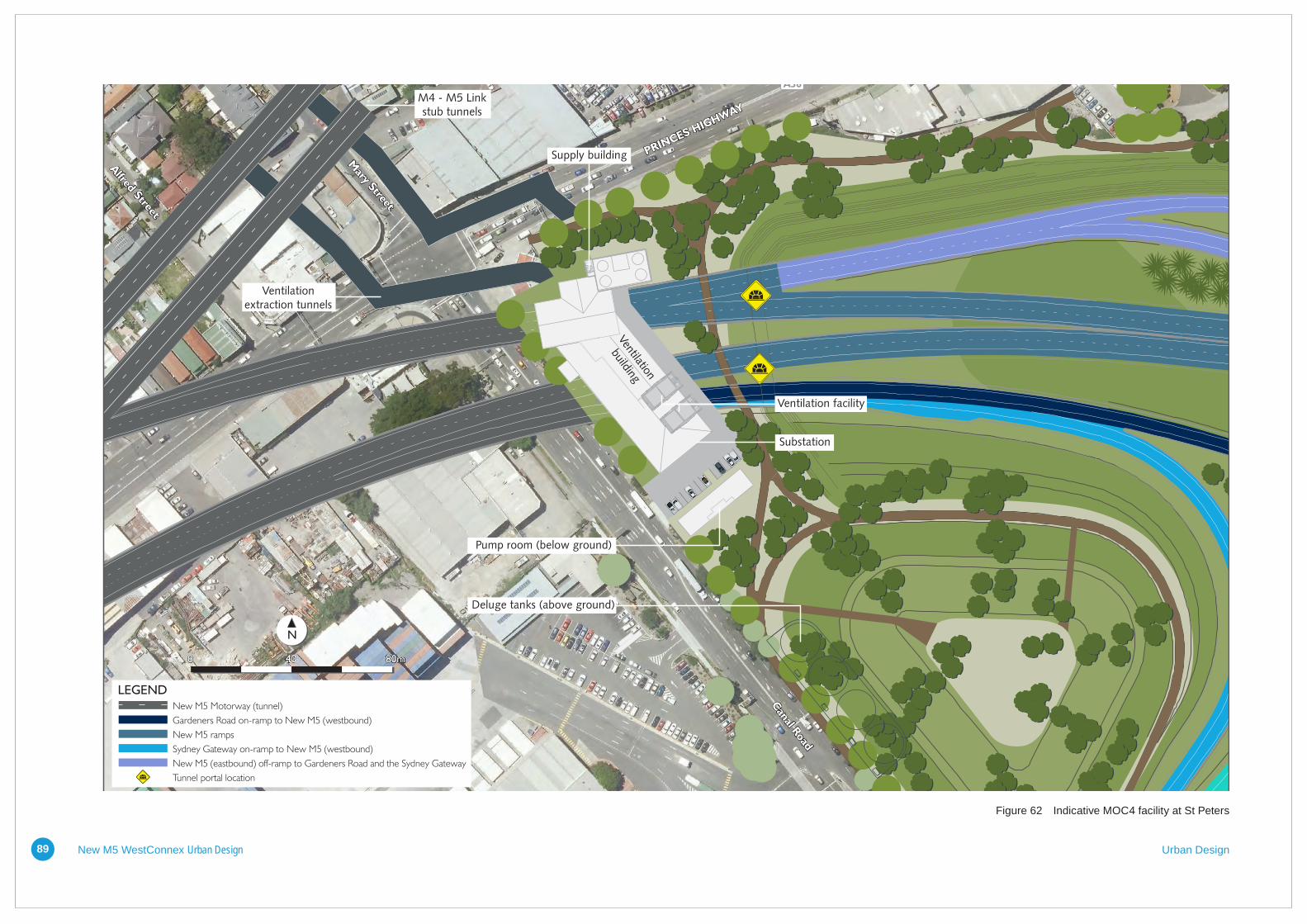
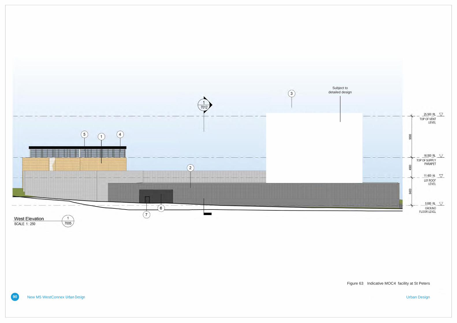
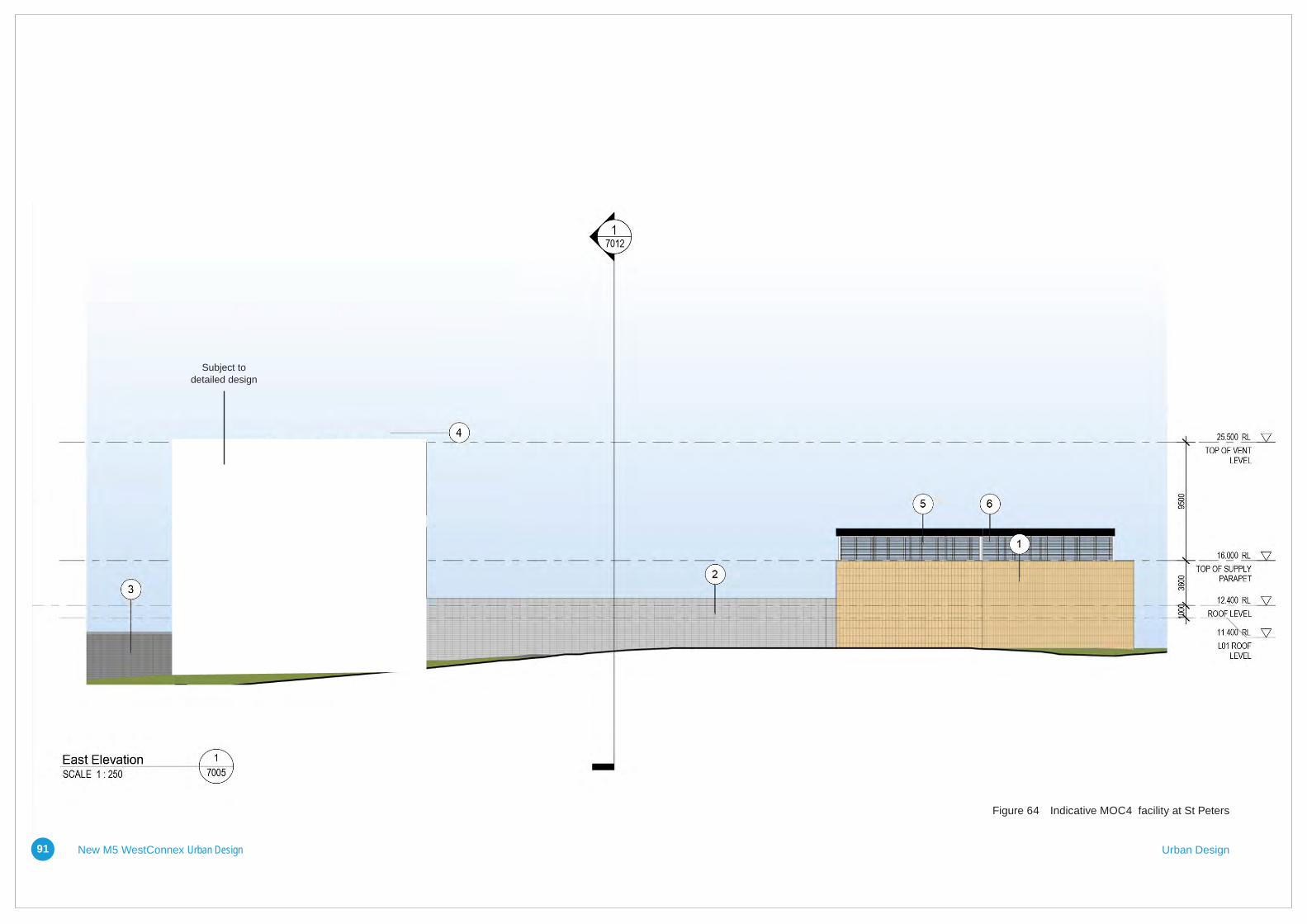
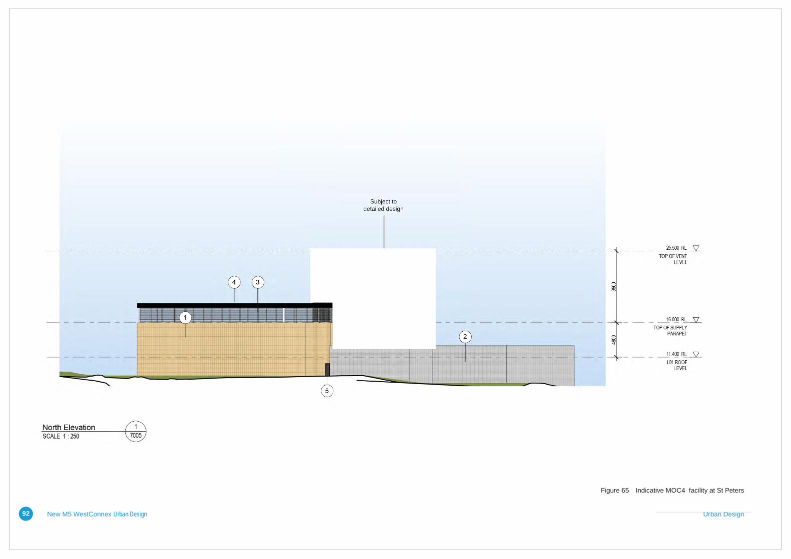
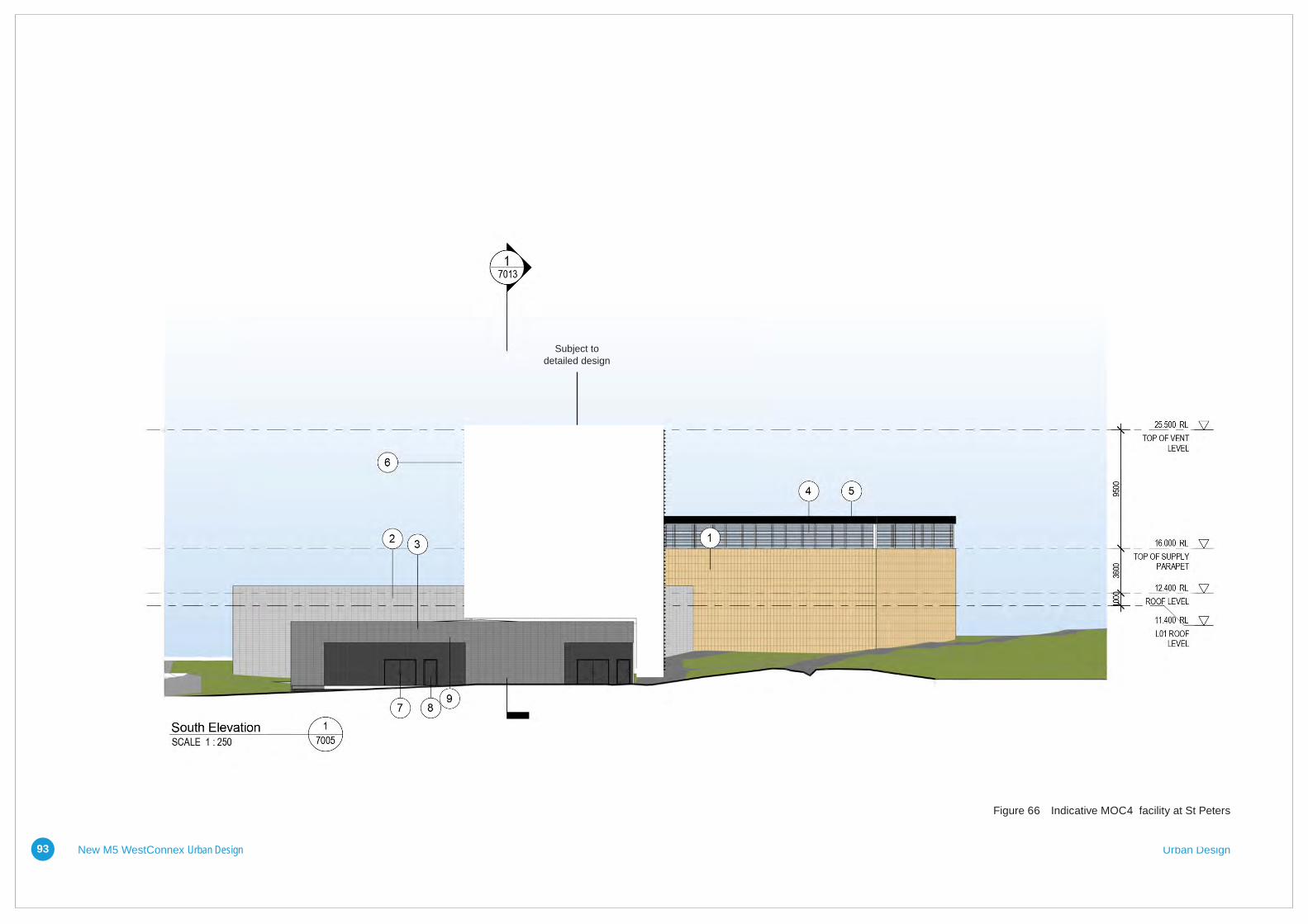
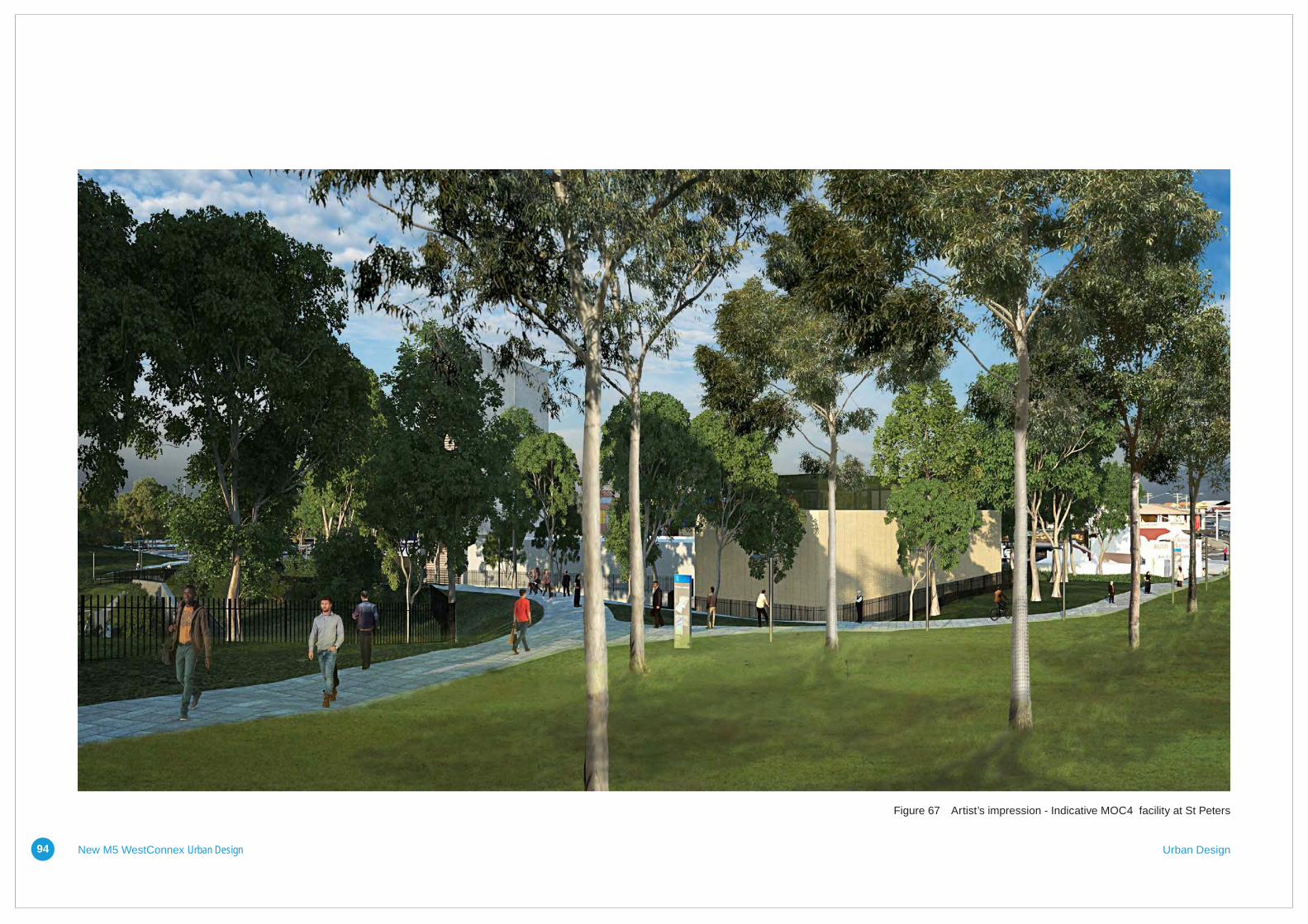
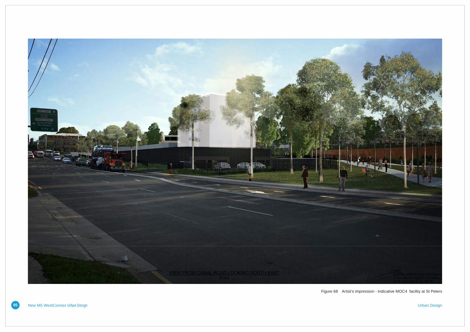
5.7.5 Canal Road Complex
Design intentThe facility at Canal Road (MOC4), St Peters is conceived as one building articulated through form and material to express the three main functions within. The building is nestled into the sloping site to reduce its apparent height and respond to its context. The lowest section of the building, which fronts Canal Road and wraps around the southern end, houses the distribution substation. Immediately adjacent and slightly higher the exhaust ventilation equipment is placed in a two level section, the lower level being entirely below ground.
Horizontally oriented fans allow for a lower overall building. Horizontally oriented terracotta façade panels emphasise the low nature of the building, with the ventilation facility rising up from the southern end. The vertical structure is visually separated from the horizontal building. The design of the ventilationfacilitywillbefinalisedinaccordance with the methodology outlined in section 5.2.
Materials, colours and finishesThe horizontal portions of the building are clad in horizontally oriented dark and light grey terracotta façade panels – responding to the predominantly masonry construction of the residential houses nearby. Openings providing service access to the plant rooms are grouped into common recesses, exposing the structure – a smooth-faced concrete block (stack bond pattern). Access doors within the block work are painted to match. The lower scale supply building is clad in vertically oriented terracotta panels whichreflectitsfunctionandverticalitywhilst acknowledging its moderate scale.
The following pages provide preliminary site plans, elevations and perspectives of MOC4. These plans would be developed during the detailed design of the project.
New M5 WestConnex Urban Design Urban Design89
Mary Street
A36
Alfred Street
Canal R
oad
Supply building
Ventilation
building
Substation
Pump room (below ground)
Deluge tanks (above ground)
Ventilation facility
M4 - M5 Linkstub tunnels
Ventilationextraction tunnels
0 80m40
Tunnel portal location
New M5 Motorway (tunnel)
Gardeners Road on-ramp to New M5 (westbound)
New M5 ramps
Sydney Gateway on-ramp to New M5 (westbound)
New M5 (eastbound) off-ramp to Gardeners Road and the Sydney Gateway
LEGEND
N
Figure 5-41 St Peters motorway operations complex (MOC 4)Figure 62 Indicative MOC4 facility at St Peters
New M5 WestConnex Urban Design Urban Design90
Subject to detailed design
Figure 63 Indicative MOC4 facility at St Peters
New M5 WestConnex Urban Design Urban Design91
Subject to detailed design
Figure 64 Indicative MOC4 facility at St Peters
New M5 WestConnex Urban Design Urban Design92
Subject to detailed design
Figure 65 Indicative MOC4 facility at St Peters
New M5 WestConnex Urban Design Urban Design93
Subject to detailed design
Figure 66 Indicative MOC4 facility at St Peters
New M5 WestConnex Urban Design Urban Design94
Figure 67 Artist’s impression - Indicative MOC4 facility at St Peters
New M5 WestConnex Urban Design Urban Design95
Figure 68 Artist’s impression - Indicative MOC4 facility at St Peters