Embed Size (px)
Citation preview

6 April 2016

Cadastre NSW Stakeholder Analysis Report
2
Contents Executive Summary ............................................................................................................................................... 3 1. Introduction ................................................................................................................................................ 7 1.1 Background ................................................................................................................................................. 8 1.2 Purpose ....................................................................................................................................................... 8 1.3 Structure ...................................................................................................................................................... 9 1.4 Methodology ................................................................................................................................................ 9 1.5 Next Steps ................................................................................................................................................... 9 1.6 Terms and Acronyms ................................................................................................................................ 10 2. Current arrangements ............................................................................................................................. 11 2.1 Legislative Framework............................................................................................................................... 11 2.2 Technical Standards .................................................................................................................................. 14 2.3 Roles and Responsibilities ........................................................................................................................ 15 2.4 Creating and updating the digital cadastre ................................................................................................ 21 2.5 Exchange/sharing of associated datasets ................................................................................................. 25 2.6 Fees and Charges ..................................................................................................................................... 25 3. Digital cadastre: problems and opportunities ...................................................................................... 26 3.1 Proposed plan data is not consistently distributed .................................................................................... 26 3.2 Users are uncertain about the cadastre’s accuracy .................................................................................. 28 3.3 Lack of co-ordinated minimum NSW cadastre .......................................................................................... 31 4. Potential Benefits .................................................................................................................................... 35 4.1 Building Infrastructure - More cost-efficient, reliable and safer ................................................................. 35 4.2 Housing Affordability and Supply - Reduce land and property development costs .................................. 37 4.3 Digital Economy - Facilitate the development of a location enabled digital economy for NSW ................ 39 4.4 Better Services and Safer Public - Strengthen strategic planning, decision making, compliance,
enforcement and prosecution .................................................................................................................... 40 4.5 Fit for Future - improved efficiency of council operations.......................................................................... 41 5. Strategic Alignment with NSW Premier and State Priorities and current reforms ........................... 42 5.1 Strategic Alignment with NSW Premier and State Priorities ..................................................................... 42 5.2 Alignment with NSW Government Reform Agenda .................................................................................. 42

Cadastre NSW Stakeholder Analysis Report
3
Executive Summary Background
The way land is managed is crucial to the economic, social and environmental prosperity of New South Wales. Informing any land related policy, regulatory process or decision requires knowledge of who owns land and/or has any documented interest in it. The digital cadastre, spatially representing the division of land ownership across the state, is the primary link necessary to identify these interests and better manage the $1.34 trillion of land in NSW. 1
In NSW however there is no common digital representation of the cadastre used across governments and industry. Instead, it is estimated that there are over 100 cadastral datasets being maintained on a day to day basis, resulting in significant duplication of resources, a higher regulatory burden on industry, constraining decision making and unnecessary barriers to digital government services.
In 2015 the NSW Location Leadership Group (LLG) updated the NSW Location Intelligence Strategy, Locate+ and committed to improving NSW’s cadastre. As part of this commitment, the Cadastre NSW Working Group (CNWG) was subsequently formed, and consists of government and private sector representatives. CNWG is seeking ways to improve the way cadastral information is sourced, managed and delivered across NSW.
To assist in analysing stakeholder issues in regards to the digital cadastre, Jacobs Group (Australia) were engaged in November 2015, to facilitate four one-day workshops (local councils, state government, utilities, industry). These workshops were designed to establish a consensus regarding problems and opportunities relating to cadastral and associated datasets and the potential benefits of cadastral reforms. The findings will be used by the CNWG to develop a business case for NSW Treasury by late 2016.
Overview of Current Arrangements
Forty-six representatives from NSW local councils, NSW government agencies, utility providers and industry responded to tailored surveys designed to capture details about current arrangements regarding cadastral and associated datasets. Collectively the respondents identified that they:
• Spend over $19 million per annum on creating, maintaining, updating the cadastre and associated datasets.
• Employ over 275 people to create, maintain and update their cadastres and associated datasets.
Stakeholders were also concerned about a lack of coordination between the custodians/users of the cadastre and associated datasets. They noted that NSW legislation does not prescribe any roles and responsibilities for the maintenance of a digital cadastre, however legislative reform was considered by some to be too difficult and even unnecessary if coordination can be achieved through other means.
Problems and Opportunities Figure E1-1 – Problems and Opportunities identified by stakeholders
1 Sydney’s West Leads the Way in Land Values Growth,’ Media Release (7 January 2016), NSW Dept. of Finance, Services and Innovation,
https://www.finance.nsw.gov.au/about-us/media-releases/sydneys-west-leads-way-land-values-growth (accessed 2 February 2016).

Cadastre NSW Stakeholder Analysis Report
4
Stakeholders identified three priority problems and opportunities associated with the current management of the NSW digital cadastre (Figure E1-1).
Proposed plan data is not consistently distributed
This problem is primarily caused by:
• A lack of mandated requirements or mechanisms by which local councils can capture and disseminate proposed plans during the early stages of land and property development.
• The reliance on ad-hoc enquiry/email transmission of proposed plans and address details due to the lack of a single source of information and a uniform process for accessing information.
Reported impacts included:
• Costly regulatory processes for the final approval of new homes due to the need to manually validate, manipulate and update data sets about location information on site.
• Delays in connecting utilities to new homes.
• Delays in emergency services (ambulance, fire and police) responding to calls to new subdivisions or those under development.
• Constrained utility network capacity planning.
Stakeholders believed that a solution to this problem can be achieved in the short term (0-2 years) by implementing change in processes and existing systems.
Users are uncertain about the cadastre’s accuracy
Several factors cause the variable accuracy of the cadastre:
• The accuracy of historical cadastral records has often not been verified since digitisation in the 1980s-1990s.
• The position of utility infrastructure recorded on plans often highlights inaccuracies in the cadastre. Some organisations update the position of the cadastre to match their infrastructure.
• Many local councils and utility providers maintain their own cadastre. Updates to individually maintained cadastres are not uniformly coordinated. Local councils (especially rural and regional councils) don’t have sufficient resources to regularly review the accuracy of their cadastre.
User’s uncertainty of the cadastre’s accuracy results in:
• Delayed and increased cost of infrastructure and property development.
• Uncertainty of the location of underground utility assets.
• Reduced ability to enforce regulation and perform statutory obligations (e.g. illegal clearing, illegal dwellings).
• Delayed sale of public assets.
Improvements to the cadastre's accuracy can be achieved in the medium term (3-5 years) through digitisation of cadastral records and implementation of progressive and targeted changes in processes and existing systems.
Lack of a co-ordinated minimum NSW cadastre
The lack of coordination regarding the cadastre and associated datasets means that:
• There is no agreed set of features and attributes that, at a minimum, meet the business requirements of all (or the majority of) stakeholders.
• The number of associated layers maintained by NSW organisations (one Council reported that they maintain over 300) results in a significant cost barrier to the future adoption of a single land cadastre.

Cadastre NSW Stakeholder Analysis Report
5
• Significant time is needed for users to add to or modify the digital cadastre to make it fit for purpose for their organisation.
• Users of the cadastre maintain their own versions to simplify and control the timing of update processes, and mitigate delays in receiving updates from other agencies.
• Links between the digital cadastre, registered title and other property information, are not complete.
Reported impacts included:
• Significant duplication of resources, seen in the maintenance of different versions of the cadastre. One local council reported spending approximately 2 years undertaking a project to improve the accuracy of their cadastre, which included comparing NSW Land and Property Information’s state-wide cadastre with their own.
• Barriers to increased delivery of digital government services, such as automating planning certificates.
• Delays in processing the sale of crown land.
• Reduced accuracy of land valuations.
Improvements to address the lack of a coordinated minimum cadastre for NSW can be achieved in the medium - long term (5 years) by implementing progressive and targeted changes in processes and existing systems.
Benefits
Stakeholders believed addressing the problems outlined above will potentially generate benefits in five areas (Figure E1-2).
Figure E1-2 – Potential benefits of addressing identified problems

Cadastre NSW Stakeholder Analysis Report
6
Strategic Alignment with NSW Government Priorities The potential benefits are aligned with NSW Premier and State Priorities and are discussed in Table E1-1.
Table E1-1 - Alignment of potential NSW cadastre reform benefits with NSW Premier and State Priorities
Next Steps
The findings of this report will be used by the CNWG to inform the development of a business case for Cadastre NSW and generate further support for cadastral reform in NSW. The Cadastre NSW business case must be prepared in accordance with the NSW Treasury Guidelines for Capital Business Cases, ready for the next round of funding bids in October 2016.
The business case must include the quantification of the potential benefits, identification of a range of options to realise the benefits, assessment of the options and justification of a preferred solution. The Cadastre NSW Stakeholder Analysis Report will enable CNWG to proceed quickly to business case development.

Cadastre NSW Stakeholder Analysis Report
7
1. Introduction Informing any land related policy, regulatory process or decision requires knowledge of who owns land or has any documented interest in it. The digital cadastre, spatially representing the division of land ownership across the state, is the primary link necessary to identify these interests and better manage the estimated $1.34 trillion of land in NSW.2 In NSW the property sector contributes over $25 billion per annum to gross state product (approximately 5.1 per cent of the total gross state product).3
The digital cadastre, (commonly referred to as a digital cadastral database or DCDB), represents the spatial extent of land parcels and property in NSW together with features such as road, rail and waterway corridors. The public and private sector can plan, design, deliver, operate or regulate assets, services and projects more effectively, efficiently and with less safety and financial risks with accurate, reliable and consistent cadastral and associated datasets (e.g. Local Environment Plan maps and underground utility infrastructure models).
However, NSW does not have a single digital cadastre that is used across governments and industry. It is estimated that there are over 100 digital cadastral datasets being maintained in NSW. Time spent overcoming the duplication and mis-alignment of information from these multiple sources adds a significant cost to government and industry. To address these concerns, many stakeholders such as councils and utility providers maintain their own version of the digital cadastre which represent the same core information but vary in their spatial positioning, attribution and the type of features displayed.
Below is an example of the digital cadastre maintained by Land and Property Information (LPI). Figure 1-1 shows the title reference and approximate extent for each parcel.
Figure 1-1 – Example of the digital cadastre
2 ‘Sydney’s West Leads the Way in Land Values Growth,’ Media Release (7 January 2016), NSW Dept. of Finance, Services and Innovation,
https://www.finance.nsw.gov.au/about-us/media-releases/sydneys-west-leads-way-land-values-growth (accessed 2 February 2016). 3 Independent Review of the Building Professionals Act 2005 Discussion Paper, May 2015, NSW Government Building Professionals Board, p. 4.

Cadastre NSW Stakeholder Analysis Report
8
1.1 Background
The NSW Government initiative to develop a digital land cadastre has been an ongoing process since the 1980s. The digital cadastre originated with the conversion of hardcopy mapping to digital format and has evolved in terms of content, accuracy and completeness over time in response to technology changes and user expectations.
Under the Surveying and Spatial Information Act 2002 the NSW Surveyor General is legally responsible for the integrity of the NSW cadastre. Improving the NSW cadastre and delivering a leading digital database representation fit for purpose as its source, will rely on the support and active participation of surveyors, local councils, utilities and NSW State Government Departments and Agencies.
The NSW Location Leadership Group (LLG) has recently updated the NSW Location Intelligence Strategy, Locate+, which includes a strategic objective to deliver a single land cadastre for NSW. Consequently, to manage the development of a single minimum cadastre, the Cadastre NSW Working Group (CNWG) was formed in 2015. Comprising government and industry representatives, the CNWG is seeking ways to improve the way cadastral information is sourced, managed and delivered across NSW.
A workshop in July 2015 brought together representatives from state and local governments and industry to develop a vision and strategic roadmap for Cadastre NSW. Figure 1-2 summarises the agreed vision and key actions to be completed by late 2016.
Figure 1-2 – Proposed Vision and Strategic Roadmap for the future management of NSW DCDB4
The CNWG plans to submit a business case for Cadastre NSW to the NSW Department of Treasury in October 2016. NSW Land and Property Information (LPI), on behalf of the CNWG, engaged Jacobs Group (Australia) to manage the Cadastre NSW Stakeholder Analysis project, which forms a key element of the strategic roadmap and informs the business case development. This report documents the results of the project.
1.2 Purpose
The Cadastre NSW Stakeholder Analysis project seeks to: 4 Co-Design Workshop – Summary of Outcomes. Single Land Cadastre for NSW, LPI, 2015, p. 3.

Cadastre NSW Stakeholder Analysis Report
9
• Gather information and document an assessment of the current state of cadastral and associated data sets and their creation, maintenance and usage.
• Gain an in-depth understanding of the problems and opportunities that exist in relation to the management of the NSW cadastre and associated datasets.
• Investigate potential benefits that may be gained by addressing the identified problems and opportunities.
1.3 Structure
This report is divided into five sections:
• Section 1 – Introduction – describes the background, purpose, scope and methodology used.
• Section 2 – Current Arrangements – outlines the current arrangements for the management of the NSW DCDB and associated datasets.
• Section 3 - Problems and Opportunities – examines the current problems and opportunities in regards to the current management arrangements for the NSW cadastral and associated datasets. For each problem and opportunity identified, the cause and effect is described.
• Section 4 – Potential Benefits – the potential benefits of addressing the problems and opportunities are analysed in section four. Evidence of potential benefits is provided using case studies from other jurisdictions and qualitative statements provide by stakeholders to illustrate the size of the potential benefits. The potential benefits have not been quantified.
• Section 5 – Strategic Alignment with NSW Government Priorities – summarises the NSW Government and specific NSW Premier’s priorities the potential benefits would contribute to/align with.
The research methodology and workshop notes are included in the appendices which are available upon request:
• Appendix A – Methodology
• Appendix E – NSW Local Councils
• Appendix F – NSW State Government Agencies and Departments
• Appendix G – Utility Providers
• Appendix H – Industry
1.4 Methodology
Four separate sectors were engaged - NSW state government agencies and departments, industry incorporating surveyors and property/construction related firms, utility providers and local councils. The engagement methodology was designed with reference to the guidelines for capital business cases published by NSW Treasury5. Three key methods were used (refer to Appendix A- available upon request from LPI):
• Desktop review of existing information and reports regarding current digital cadastral management arrangements.
• An online survey customised to each sector.
• A one day workshop for each sector.
1.5 Next Steps
The findings of this report will be used by the CNWG to inform the development of a business case for Cadastre NSW and generate further support for cadastral reform in NSW. The Cadastre NSW business case must be
5 Guidelines for Capital Business Cases - Office of Financial Management Policy & Guidelines Paper. New South Wales Department of Treasury,
December 2008, 42pp. http://www.treasury.nsw.gov.au/__data/assets/pdf_file/0020/12953/tpp08-5.pdf

Cadastre NSW Stakeholder Analysis Report
10
prepared in accordance with the NSW Treasury Guidelines for Capital Business Cases, ready for the next round of funding bids in October 2016.
The business case must include the quantification of the potential benefits, identification of a range of options to realise the benefits, assessment of the options and justification of a preferred solution. The Cadastre NSW Stakeholder Analysis Report will enable CNWG to proceed quickly to business case development.
1.6 Terms and Acronyms
Table 1-1 defines the key terms used in the report. Table 1-2 lists a range of acronyms used in the report.
Table 1-1 – Key Terms
Table 1-2 – Acronyms

Cadastre NSW Stakeholder Analysis Report
11
2. Current arrangements This section outlines current arrangements for the creation and maintenance of the different versions of the digital cadastre being used across NSW. A brief synopsis of the legislative framework is provided, followed by a summary of related activities by each sector. An overview of the NSW land development process is used to highlight the important role digital cadastral information has in the creation of new housing stock.
2.1 Legislative Framework
2.1.1 Legislated roles and responsibilities
There is currently no specific NSW legislation or regulation prescribing roles and responsibilities for digital cadastral information. There are no mandated procedures or processes enforceable by a specific entity regarding who and how the NSW digital cadastre is to be maintained.
LPI’s legislative obligations relate to the requirements for cadastral surveys and management of a register of land titles. These obligations are prescribed under the Surveying and Spatial Information Act 2002,6 Conveyancing Act 1919, Surveying and Spatial Information Regulation 20127 and Surveying and Spatial Information Regulation 2006.8 Under the Surveying and Spatial Information Act 2002, the Surveyor General is responsible for the integrity of the state cadastre, although this does not explicitly refer to the cadastre’s digital representation. The only specific requirement is in clause 17 of the Conveyancing (General) Regulation 2013, which stipulates that a record of the location and name of roads must be maintained in reference to the DCDB.
The Surveyor General and Registrar General supplement these items of legislation with the Surveyor General Directions and Registrar General Directions.9 These documents provide specific guidance regarding how a survey is to be conducted and recorded as distinct from how the information captured from the survey is to be combined, stored and shared in the form of a digital cadastre.
Other relevant Acts and Regulations (refer to Appendix B, available from LPI upon request) relating to the documentation of cadastral surveys, the preparation, registration and cataloguing of survey plans, the issue of land titles and the maintenance of this data in a land register include:10
• Conveyancing Act 1919
• Conveyancing (General) Regulation 2013
• Strata Schemes Management Act 1996
• Strata Schemes (Freehold Development) Act 1973
• Strata Schemes (Leasehold Development) Act 1986
• Strata Schemes Management Regulations 2010
• Strata Schemes (Leasehold Development) Regulations 2012
• Strata Schemes (Freehold Development) Regulations 2012
• Community Land Management Act 1989
• Community Land Management Regulation 2007
It should be noted On 27 October 2015, the NSW Parliament passed the Strata Scheme Management Bill 2015 and Strata Scheme Development Bill 2015. These will supersede existing strata legislation in the second half of 2016.
6 Surveying and Spatial Information Act 2002 - http://www5.austlii.edu.au/au/legis/nsw/consol_act/sasia2002362/. 7 Surveying and Spatial Information Regulation 2012 -
http://www.lpi.nsw.gov.au/__data/assets/pdf_file/0009/171999/Surveying_and_Spatial_Information_Regulation_2012.pdf (accessed 5 January 2016)
8 Surveying and Spatial Information Regulation 2006 - http://www.legislation.nsw.gov.au/inforcepdf/2006-530.pdf?id=8072f6c0-fcc1-6e0e-f029-9a98877e3f79 (accessed 5 January 2016).
9 “Surveyor General’s Directions”, NSW LPI, http://www.lpi.nsw.gov.au/surveying/publications/surveyor_generals_directions (accessed 15 January 2016).
10 Strata Schemes Acts and Regulations will shortly be superseded by new Strata legislation.

Cadastre NSW Stakeholder Analysis Report
12
2.1.2 NSW Government legislative obligations which depend on a digital cadastre
A range of legislative obligations necessitate the need to create and maintain a digital cadastre, although legislation doesn’t prescribe its usage. Over time, reliance on the digital cadastre by NSW Government agencies, councils and regulatory bodies to perform a variety of vital functions has become common practice. Its proper usage relies on a shared understanding of how the digital cadastre is created and maintained.
Stakeholders generally viewed the need for greater or more explicit legislative recognition of the digital cadastre as unnecessary. Technological advancements and evolving digital cadastre requirements may be constrained by legislation that is too prescriptive. Generally stakeholders believed better co-ordination and definition of existing roles and responsibilities would be sufficient (e.g. stakeholders raised the need for standard naming conventions for the attribution of the cadastre) and could be achieved outside of legislation.
Several stakeholders raised the need to consider and address:
• The legal recognition of a single digital cadastre, particularly as plans and maps are increasingly digitised and published through open data channels.
• The legal recognition of digital planning data rather than of PDF plans. This will facilitate the inclusion of planning data in the digital cadastre and assist in maintaining a higher level of data/spatial accuracy.
• Clarification regarding the role of the Registrar General in examining and reviewing plans lodged by registered surveyors. In Queensland, for example, much greater responsibility is carried by the registered surveyor, rather than the body registering the cadastral plans.
Notable examples of legislative functions which depend on the digital cadastre include:
• Statutory planning
• Management of native vegetation
• Acquisition of land for public roads
• Determination of local government boundaries and electoral district boundaries
Statutory Planning
The Environmental Planning and Assessment Act 1979 allows for environmental planning instruments to manage the use of land and protect the environment. Under the Standard Instrument – Principal Local Environmental Plan (LEP) maps are a compulsory part of a LEP.11
In practice these maps are generated by categorising parcels in the digital cadastre against standard planning layers (such as zone, minimum lot size etc.). Only the NSW Department of Planning and Environment’s standard technical requirements for spatial datasets and maps reference the cadastre by stating a preference for use of LPI’s digital cadastre as the base dataset.
Native Vegetation Management
The Native Vegetation Act 2003 requires property vegetation plans be submitted as part of any application to clear land. Plans must be endorsed by all landholders and other persons having a prescribed interest in the land. Identification and verification of landholders and other persons with a prescribed interest in the land necessitates the use of or reference to the cadastre. No specific reference is made in the Native Vegetation Act 2003 to the use of or reference to the digital cadastre. The plans must be registered by the Registrar General and thereby linked back to the digital cadastre.
Acquisition of land for roads
The Roads Act 1993 sets out how land is to be acquired by the Minister, Road and Maritime Services (RMS) or a local council for the purpose of developing a new, or expanding an existing, public road.
11 Maps were prescribed as a compulsory part of a LEP in 2006.

Cadastre NSW Stakeholder Analysis Report
13
When considering whether to acquire land, a plan of the land must be made available for inspection by the public and apparent land owners. This plan uses information from the digital cadastre to identify the extent of land to be acquired. There is no specific reference in the Roads Act 1993 mandating the use of the digital cadastre in this process.
Determination of LGA boundaries and electoral district boundaries
Determination of local government area (LGA) boundaries and electoral district boundaries are undertaken according to the Local Government Act 1993 and Parliamentary Electorates and Elections Act 1912. Both Acts refer to maps and plans which identify the location of boundaries and must be provided to the Surveyor General for inclusion in the register of public surveys.
There is no reference to the digital cadastre in either Act despite it being used as the base data for generating these maps and plans.
Other jurisdictions DCDB legislative framework
Other jurisdictions have grappled with legislative recognition of a digital cadastre. Table 2-1 summarises the legislative frameworks around the digital cadastre in Western Australia, South Africa, Denmark and Japan (refer Appendix C for detailed case studies, available upon request from LPI).
Western Australia has similar legislative arrangements to NSW. The Western Australian Land Information Authority is responsible for the maintenance of the integrity of the Western Australian Land Register (commonly referred to as the Spatial Cadastral Database). The Land Information Act 2006 (WA) doesn’t prescribe what form the Land Register should take or how it should be maintained and shared.
In contrast to current legislative arrangements in NSW, Denmark and South Africa mandate through legislation the use of a national cadastre by all public authorities and the provision of access to the national cadastre by a single entity (e.g. body responsible for spatial data information).
The Victorian Spatial Council has identified a need for legislation in providing a framework for the management of spatial information that underpins the State’s framework data sets, in particular the Land Administration Themes data12. Current legislation, particularly in relation to local government, provides no legislative mandate for the custodians of key property related information to provide this information to support the maintenance of these datasets. The current maintenance processes rely on historical relationships and the goodwill of key people in local government and utility organisations. In addition there is a need for providing a framework for standards to provide consistency in the provision of data by custodians. The Victorian Spatial Council’s work program for the next three years aims to garner support within government and stakeholders for the development and introduction of appropriate legislation.
12 VSC Position Paper No. 2-2015, July 2015, http://victorianspatialcouncil.org/cms/library/attachments/VSC%20Position%20Paper%20No.2-
Legislation%20v0.2.pdf (accessed 5 January 2016).

Cadastre NSW Stakeholder Analysis Report
14
Table 2-1 – Key features of a digital cadastre legislative framework in other jurisdictions
2.2 Technical Standards
Technical standards exist in relation to cadastre (refer to Appendix D, available upon request from LPI). Standards are not mandated in NSW legislation. Key standards include:
• Intergovernmental Committee on Surveying and Mapping (ICSM) Harmonised Data Model (version 2, 2008) facilitates the national compilation of cadastre from each jurisdictions through common naming conventions.
• NSW Cadastral Data Dictionary (version 2.5.10) – defines the data structure and content for LPI’s digital cadastre.
• LandXML Schema (version 1.2), ICSM LandXML Mapping Specification (version 2.1) and NSW LandXML Recipe (version 7.5.3) – non-proprietary data standard that is used to exchange survey plan data between

Cadastre NSW Stakeholder Analysis Report
15
different systems. LPI are currently implementing a digital ePlan system in NSW for the electronic lodgement and analysis of cadastral plans with LandXML.
• Rural and urban addressing standard (AS/NZS4819:2011) – defines the structure and format for property addresses.
• Standard Technical Requirements for Spatial Datasets and Maps (2015, NSW Department of Planning and Environment) – defines technical requirements for creating and updating maps for planning purposes including use of the NSW cadastre.
Stakeholders recognised the existence of technical standards and in most part believed their organisations sought to comply with the relevant standards.
2.3 Roles and Responsibilities
2.3.1 Local councils
Creating and maintaining digital cadastres
The majority of NSW local councils maintain their own in house digital cadastre.13 In many cases the dataset is based on a copy of LPI’s cadastre at a point in time, but has been updated or adjusted independently since then.14
Local councils update their digital cadastre in-house using:
• New survey plans supplied to local council as part of the development application or subdivision and strata certification process.
• Registered survey plans provided to local councils by LPI through the Spatial Information Exchange (SIX).
• Updates made to LPI’s digital cadastre and delivered through various channels, such as a daily incremental feed and web services.
Updating the digital cadastre can involve:
• Edits to existing parcels within the local council’s digital cadastre to ensure more accurate boundaries are reflected.
• Edits to record proposed parcels which have reached a particular stage of the development process. Significant variability exists for when proposed parcels are entered into the digital cadastre by councils.
• Edits to update the digital cadastre at plan registration. The council will either digitise a copy of the plan, made available upon registration through SIX, or manipulate the updated parcels in LPI’s digital cadastre to fit council’s version.
A minority of NSW local councils use only LPI’s digital cadastre. Updates are usually received through a daily incremental feed or periodic data update. A number of councils indicated that they would like to move to LPI's cadastre. However, they are restricted from doing so because of transition costs and data misalignments.
Changes to the adopted digital cadastre will often necessitate changes to other spatial datasets produced by local councils (e.g. plans showing the location of assets, easements and other information classifying parcels in various ways). In some instances, changes in the cadastre may also result in changes to the extent of parcels classified in a certain way (such as flood prone or bush fire prone). Local councils are also required to provide the NSW Department of Planning and Environment (DP&E) with a copy of their digital cadastre as part of the LEP creation and amendment process. Often this means also maintaining an older version of the digital cadastre which aligns with the LEP provided to DP&E.
13 Information sourced from the local government surveys and one day workshop organised by Jacobs in December 2015. 14 Ibid.

Cadastre NSW Stakeholder Analysis Report
16
Twenty-three (23) local councils were surveyed15 to gauge the size and scale of effort expended in creating and maintaining their cadastres and associated datasets. The estimated level of resourcing identified across Local Government in NSW was:
• 70 – 80 people are employed on a full time basis to create and maintain the digital cadastre and associated datasets by the 23 local councils. The majority of local councils have three or less employees creating and maintaining the cadastre and associated datasets (e.g. property layers, planning layers, asset information and associated datasets (refer Figure 2-1).
• A significant amount of time is spent by local council employees checking cadastral data received from outside parties against their own digital cadastre (refer to Figure 2-2). 13 local councils reported their staff spend between 25-75% of their time checking and verifying the accuracy of new or updated cadastre received.
• $4 – $5 million per annum is estimated to be spent by the 23 local councils on services and staff related to managing their digital cadastre and associated data. The majority of local council’s estimate their spend to be between $0 – $250,000.00 per annum (e.g. includes staff costs, consultant/contractor costs, data acquisition costs, digital cadastre system costs) (refer to Figure 2-3).
Figure 2-1 – Estimated number of local council employees involved in the creation and maintenance of council’s cadastral and associated datasets
Figure 2-2 – Estimated time spent by local council employees checking data against their cadastre
Figure 2-3 – Estimated spend per annum by a local council on creating, updating, storing and publishing cadastre and associated data
A simple extrapolation of survey findings across the 152 NSW local councils (15% of local councils were surveyed by Jacobs and LPI16) estimates the creation and maintenance of DCDB and associated data requires:
• 400 – 500 full time local council employees.
• $20 - $30 million per annum expenditure by local councils.
15Jacobs and NSW LPI Online Survey. Refer to Appendix A.2 for an overview of the survey. Appendix is available upon request from LPI. 16 Extrapolation simply involves dividing the survey findings regarding staffing levels and expenditure by the number of survey respondents and
multiplying by 152. This doesn’t take in regard the differentiation in staffing levels and expenditure that exists between rural, regional and city councils.

Cadastre NSW Stakeholder Analysis Report
17
Using digital cadastres
A local council will use digital cadastres to:
• Produce and verify planning certificates (section 149) for development applications and property sale transactions.
• Review proposed developments against planning scheme zoning.
• Define lots (e.g. assign council property numbers, address and rates notices).
• Provide the base map for locating council assets (e.g. drainage, road furniture, properties etc).
• Provide the base map for planning zone definition or proposed zone changes.
• Map the location of information contained in customer enquiry, maintenance works, asset management and ratings systems.
2.3.2 NSW Land and Property Information
NSW Land and Property Information (LPI) is the custodian of the state-wide digital cadastre and maintains it primarily as a spatial index to the register of NSW land parcel titles (known as the integrated titling system). LPI’s digital cadastre collates the individual registered plans defining land into a single fabric of parcel boundaries for the state along with associated attribute information. Using LPI’s cadastre, land parcels can be identified and matched to the appropriate title information, enabling land ownership details to be obtained.
LPI update their cadastre using plans lodged by registered surveyors or other government departments. Once survey plans are lodged with LPI, the plans are examined to ensure they align with pre-existing plans and meet survey regulations and requirements. After registration, new titles are issued and the LPI digital cadastre is updated.
Updating LPI’s digital cadastre typically takes days due to the manual data capture processes and data transfer and publishing mechanisms. Updates may take weeks or occasionally months if accuracy issues with new or existing plans need to be resolved.
LPI’s cadastral program employs over 30 staff in its Bathurst office to update and maintain the state-wide digital cadastre and some associated datasets, such as administrative boundaries. Various other business units within LPI are also involved in processing cadastral information and maintaining associated datasets. These include other business units within the information sourcing division, such as addressing, and all other LPI divisions, being titling and registry services, valuation services, business development and delivery and information communications and technology. It is estimated that LPI spend over $3 million per annum on updating and maintaining its digital cadastre and significantly more if associated datasets are factored in.
2.3.3 State government
Creating and maintaining digital cadastres
NSW state government departments and agencies are consumers of LPI’s digital cadastre. Ten state government departments and agencies were surveyed by Jacobs and nine indicated that they primarily source cadastral and associated datasets from LPI. Only two agencies and departments reported that they sourced cadastral and associated datasets from local councils and utility providers.
The only state government agency (apart from utility providers) that maintains a digital cadastral database is Roads and Maritime Services (RMS). The extent of their dataset is the immediate foreshore of Sydney Harbour for which they are responsible. RMS is required to approve the definition of the mean high water mark (MHWM) for every plan that abuts the harbour and as such maintains a cadastre with a higher level of accuracy than LPI's cadastre.
The survey of ten (refer to Appendix F, available upon request from LPI) state government agencies and departments shows that most have three or less employees checking and preparing cadastral and associated datasets for business use (shown in Figure 2-4) and nearly half of those employees spend between 0 – 25% of
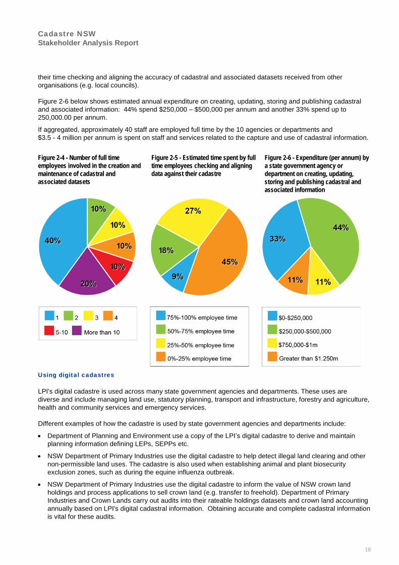
Cadastre NSW Stakeholder Analysis Report
18
their time checking and aligning the accuracy of cadastral and associated datasets received from other organisations (e.g. local councils).
Figure 2-6 below shows estimated annual expenditure on creating, updating, storing and publishing cadastral and associated information: 44% spend $250,000 – $500,000 per annum and another 33% spend up to 250,000.00 per annum.
If aggregated, approximately 40 staff are employed full time by the 10 agencies or departments and $3.5 - 4 million per annum is spent on staff and services related to the capture and use of cadastral information.
Figure 2-4 - Number of full time employees involved in the creation and maintenance of cadastral and associated datasets
Figure 2-5 - Estimated time spent by full time employees checking and aligning data against their cadastre
Figure 2-6 - Expenditure (per annum) by a state government agency or department on creating, updating, storing and publishing cadastral and associated information
Using digital cadastres
LPI's digital cadastre is used across many state government agencies and departments. These uses are diverse and include managing land use, statutory planning, transport and infrastructure, forestry and agriculture, health and community services and emergency services.
Different examples of how the cadastre is used by state government agencies and departments include:
• Department of Planning and Environment use a copy of the LPI’s digital cadastre to derive and maintain planning information defining LEPs, SEPPs etc.
• NSW Department of Primary Industries use the digital cadastre to help detect illegal land clearing and other non-permissible land uses. The cadastre is also used when establishing animal and plant biosecurity exclusion zones, such as during the equine influenza outbreak.
• NSW Department of Primary Industries use the digital cadastre to inform the value of NSW crown land holdings and process applications to sell crown land (e.g. transfer to freehold). Department of Primary Industries and Crown Lands carry out audits into their rateable holdings datasets and crown land accounting annually based on LPI's digital cadastral information. Obtaining accurate and complete cadastral information is vital for these audits.

Cadastre NSW Stakeholder Analysis Report
19
• Roads and Maritime Services and Sydney Trains, within the Transport for NSW cluster, use the cadastre to inform all phases of planning and design for new infrastructure.
• Rural Fire Service and NSW Department of Primary Industries use the digital cadastre to verify land tenure details for high risk bushfire areas.
• Mine Subsidence Board use the digital cadastre to help analyse and respond to potential mine subsidence impacts on proposed and existing buildings and assets.
2.3.4 Utility providers
Creating and maintaining digital cadastres
Seven utility providers were surveyed by Jacobs and LPI (refer to Appendix G, available upon request from LPI).17 Most maintain their own version of the digital cadastre customised to meet their individual business requirements. These datasets cover the extent of their infrastructure, usually consisting of a large number of Local Government Areas.
Utilities map their assets relative to the land boundaries in their version of the digital cadastre. When the parcel boundaries within their cadastre are adjusted to improve their spatial accuracy (either internally or via an update from LPI) there is a need to update the positioning of their assets to maintain their relativity to parcel boundaries. Utility assets must be accurately located to protect them from inadvertent striking during excavations (e.g. rupturing an underground pipe). Information on the location of underground utility infrastructure is typically provided through the digital cadastre via a dial before you dig (DBYD) search.
Survey findings indicate that the majority of utility providers have five or more employees working on the creation and maintenance of cadastral and associated datasets (shown in Figure 2-7). The utility providers surveyed employ over 100 staff full time. Half of the utility providers indicate staff spend a reasonable amount of time checking the accuracy of cadastral and associated datasets with other information received from LPI, surveyors, local councils or other utilities.
17 The survey results register 15 responses for utilities. This is because a number of organisations split their spatial/cadastre functions and therefore
a number of different respondents answered questions to portray an accurate image of organisational practices.

Cadastre NSW Stakeholder Analysis Report
20
Figure 2-7 - Number of full time equivalent employees involved in the creation and maintenance of the utility’s cadastre and associated data.
Figure 2-8 - Estimated time spent by full time employees checking and aligning data against their cadastre
Figure 2-9 - Expenditure (per annum) by the utility on creating, updating, storing and publishing cadastre and associated information.
Figure 2-9 indicates that over half of utilities surveyed spend more than $1 million per annum creating, updating, storing and publishing their cadastre and associated datasets. Collectively, the utility providers spend $9 million to $10 million per annum on staff and services related to their cadastre.
Using digital cadastres
Utilities use their digital cadastre for a range of business functions including:
• Infrastructure/network planning and design
• Asset management and maintenance
• Emergency incident response
• Customer account, billing and service management
2.3.5 Surveyors and property developers
Creating and maintaining digital cadastres
Surveyors undertake cadastral surveys to re-establish or create new cadastral boundaries through the land development process. These cadastral surveys are used by LPI, local councils and utility providers to update their version of the digital cadastre.
Surveyors will typically create a project-specific survey-accurate digital cadastral fabric as part of every cadastral project they work on. This is often used by their client as the base dataset before an accurate design or planning task can be undertaken. Applications include the design for new infrastructure, road upgrades or new buildings.
Cadastre NSW Stakeholder Analysis Report
21
Using digital cadastres
Surveyors use the digital cadastre to provide almost all of their services. Surveyors may use one or more sources of the digital cadastre, depending on the location and nature of development. It is typical for surveyors to source digital cadastral and associated information from LPI, the relevant utilities and local council(s).
Surveyors (and property developers) use digital cadastres to:
• Assist in identifying and mapping land parcels.
• Provide base lot/plan data to support the preparation of development applications, concept and subdivision layout design and survey plan preparation.
• Identify the location of underground infrastructure.
• Provide underlying boundary information for any urban or infrastructure design project.
2.2.6 Private certifiers
Private certifiers play a key role in the review and approval of new survey and strata plans as an alternative to seeking development certification through local councils. With respect to the cadastre, applications for subdivision certificates and strata certificates, required prior to lodgement with LPI, are most relevant. In 2014/15 private certifiers approved 35.8% of strata certificates, and 6.8% of subdivision certificates. 18
2.2.7 Other private sector uses of LPI’s digital cadastre
The cadastre is widely used across the private sector for a variety of purposes including:
• informing engineering design and planning for proposed major infrastructure projects
• valuation of land and real property
• marketing and sales of property in the real estate sector
• insurance claims investigations
• customer service management
2.4 Creating and updating the digital cadastre
New or updated cadastral information is an output of the land development/subdivision process. The land development process involves numerous interactions between local government, NSW state government agencies and departments (as referral authorities), surveyors, private certifiers and utility providers.
Figure 2-10 demonstrates the land subdivision process and the key stages for the approval of cadastral information by various stakeholders. Depending on the type of development, the process typically takes between six months to two years, although there are no overall time limitations imposed.
The process illustrated in Figure 2-10 is high level in order to represent commonalities across all local councils and utility providers and all development types. Significant variations may occur based on the location, type of development and the approving authorities involved.
Key differences observed in land development processes followed by local councils include:
• Use of proposed layer in the digital cadastre – some local councils:
o Don’t use a proposed layer in their cadastre and use a “dummy” record against which to hold pre-allocated addresses.
o Use a proposed layer in a subdivision certification stage.
18 Local Development Performance Monitoring Report, ePlanning, Dept of Planning and Environment,
http://www.datareporting.planning.nsw.gov.au/ldpm-download-data, (accessed 15 January 2016).

Cadastre NSW Stakeholder Analysis Report
22
o Use a proposed layer as soon as they receive a plan layout from the developer as part of the development application.
• Use of Pre-Allocated Plan Numbers (PPN) for allocating DP and lot numbers to a plan early in the development process is predominantly used in Sydney. This is predominantly because Sydney Water requires a PPN with every section 73 certificate application, allowing customers to be billed prior to plan registration.
The inset to Figure 2-10 was identified as a key area for potential improvement in efficiency for the land development process. Workshop participants indicated that the delay from final lot layout to plan registration can be significant with respect to the total development process. This is costly for industry and purchasers of new homes, as this is the point in time where the most capital is tied up in a project, resulting in significant holding costs.

Cadastre NSW Stakeholder Analysis Report
23
Figure 2-10 – NSW Land Development/Subdivision Process and interaction with the DCDB (INSET next page)

Cadastre NSW Stakeholder Analysis Report
24

Cadastre NSW Stakeholder Analysis Report
25
2.5 Exchange/sharing of associated datasets
The demand from public and private sector agencies for other spatial datasets is consistently growing. State government and local councils supply a wide range of spatial datasets used by other public and private sector organisations. The value of these spatial datasets depends significantly on their alignment with an accurate and consistent digital cadastre.
Examples of commonly and frequently shared spatial datasets between local councils, surveyors/property developers, NSW State Government agencies/departments and utility providers that are either produced using a digital cadastre as an input or overlaid on a digital cadastre are:
• Local Government Area (LGA) boundaries
• Local Environment Plans (LEPs)
• Flora, fauna and biodiversity datasets from NSW Office of Environment and Heritage (e.g. threatened species)
• Aerial imagery/LiDAR from LPI
• Location of current and abandoned mines from NSW Mine Subsidence Board
• Road safety from NSW Roads and Maritime Services (e.g. location of crashes)
• Rail and road centre line data
• National Parks, State Forests and crown land
• Vegetation mapping
• Contaminated land (e.g. Acid Sulphate Soils)
• Drainage networks
• Topographic data
• Australian Bureau of Statistics datasets
• Underground utility infrastructure maps
• Bushfire zone mapping and fire trails from NSW Rural Fire Services
• Flood zones and sea level rise data
2.6 Fees and Charges
Generally surveyors and property developers pay to access cadastral information. The fees and charges are relatively inexpensive ($14 per deposited, crown land and strata plans from LPI agents), but can add up over time (Jacobs’ 2015 survey results). A small proportion of organisations who maintain a digital cadastre also charge for access to their DCDB, but costs are usually small at around $1 per parcel.
For a small fee (~$75) extracts of LPI’s digital cadastre for individual Local Government Areas can be readily downloaded via LPI’s Spatial Information Exchange web portal. The digital cadastre is also available at no cost via SIX maps, the NSW Globe and the cadastre web map service.

Cadastre NSW Stakeholder Analysis Report
26
3. Digital cadastre: problems and opportunities This section describes the priority problems and opportunities associated with the current coordination and management arrangements of the NSW digital cadastre and associated data sets. Stakeholders agreed that all three key problem and opportunity themes, discussed below, should be addressed, given the significant dependencies between them. Figure 3-1 summarises the problem and opportunity themes to be addressed and the time frames required to address them as proposed by stakeholders.
Figure 3-1 – Change to NSW cadastre Problem and Opportunities and proposed timeframes for implementation
3.1 Proposed plan data is not consistently distributed
Proposed plan data is needed to effectively meet the needs of stakeholders involved in the land development process. Proposed plan data is used to determine a development application’s compliance with planning instruments, assess the capacity requirements of utility infrastructure and provide services to new developments, such as loans and insurance policies.
Currently, proposed plan information is provided to each stakeholder separately, often from a number of different organisations, with no mechanism to ensure each organisation is reviewing the same information. There are also limited opportunities to receive updates as changes to plans occur. These inefficient processes and the lack of consistent data result in higher costs for property development and greater risks for approving authorities.
Proposed addresses will also be assigned by a local council at some point during the development process, although this varies from council to council as well as the type of development. As proposed addresses are inherently tied to the proposed plan, coordination and the regular updating of proposed plan data is necessary to facilitate the allocation and dissemination of correct address details.
Many services provided by councils, utilities and the state government may need to be available before a plan is registered, or must be accessible immediately after plan registration. Consequently, delivering these services requires access to proposed plan data. Examples include accepting connection applications to utility services (either before or immediately after plan registration), accepting development applications and providing planning certificates for new parcels of land (immediately after plan registration) or updating drivers licence details for new property addresses.
3.1.1 Causes of Problem/Opportunity
The factors that contribute to the lack of consistent capture and dissemination of proposed plan data are:
• There is no mechanism available for surveyors and property developers to distribute proposed plan data to all stakeholders throughout the development process. This is because only final plans are referenced in LPI's digital cadastre, not proposed plans.
• There is uncertainty as to the completeness and accuracy of proposed plans due to the lack of standardised minimum requirements and quality assurance mechanisms (e.g. property developers may not have sent the

Cadastre NSW Stakeholder Analysis Report
27
latest and final plans to all authorities).19 This results from the use of potentially inaccurate data sources in the first instance, and the inability to check the accuracy or consistency of information against an authoritative point of reference.
• No legislative restriction on time exists between local council approval of cadastral plans and when they must be lodged with LPI. This increases dependency on proposed plan information, for which an accurate single source is not available. This exacerbates cadastral accuracy and reliability issues.
• Considerable time is required to check and validate the correct relationships between Lot and DP numbers and proposed and final address details. The relationship between the Lot and DP number and the proposed and final addresses can change several times during the subdivision approval process (this is particularly an issue with rural and corner blocks). Each time address information changes, relationships must be validated and maintained. However, due to the lack of appropriate processes for the dissemination of information, address details are not validated and remain inconsistent between the various stakeholders.
3.1.2 Impact of Problem/Opportunity
Lack of capture and dissemination of proposed plan data significantly impacts utility providers, local councils, property developers and emergency services. Reported impacts include:
• Inefficient resource use by local councils, utilities and property developers resulting in increased development costs and delays to the final approval of new homes
o Proposed plan data can change through the development process, resulting in changes to road layouts and proposed addresses. Many stakeholders reported frustration with having to update their systems several times during the development process as new information becomes available. Utility providers often just rely on the best information they can get, such as an indicative lot layout from a development’s master plan.
o The current linear regulatory process for survey plans requires surveyors and property developers to seek signatures from various approval authorities one by one. After the construction stages of a development have been completed, the survey plan and 88B instrument approval process (from plan creation at the end of construction work to plan registration) typically takes three or four months to complete, delaying final property settlement and increasing holding costs. While there are other factors influencing this time frame, coordination of proposed plan information is a significant contributor.
o Proposed plans are typically provided in paper or scanned image form to all approving authorities at various stages throughout the development process. As a consequence, each organisation either traces or inputs boundary data in order to quality assure the information and update their proposed information datasets. This is highly inefficient and the plans being incorporated may not be the latest versions.
• Delays in connecting new homes to utilities. A delay can be caused by:
o The utility awaiting the address details from local councils to enter into their customer management system in order to arrange for a connection despite the home being finished and ready for occupancy.
o The utility is provided with incorrect address details and is unable to approve a connection. If the wrong address data is acted upon the services could be connected to the wrong house. A utility reported on average 5 – 10 instances per year where plumbers connect a dwelling to a neighbour’s sewerage system.
• Delays in emergency services (ambulance, fire and police) responding to calls to new or subdivisions under development:
o The lack of easily accessible proposed lot layout, address and road information for new subdivisions can delay emergency service response times. Stakeholders reported various instances where emergency services were delayed by up to half an hour because they were not aware of the most direct route through a new subdivision.
19 According to stakeholder feedback during workshops, in their own version of the digital cadastre, Sydney Water uses proposed plans to connect
services to new properties. Strict quality control mechanisms are followed by Sydney Water to remove proposed plan data and replace with final plan data.

Cadastre NSW Stakeholder Analysis Report
28
• Constrained utility network capacity planning. The ability for utilities to confidently plan for future demand is constrained because they do not have visibility of all the relevant subdivision data as it changes through the subdivision process. Several utilities and surveyors indicated this has hampered planning for growth centres in outer Sydney. Property developers are likely to change the number of lots in a subdivision after having submitted a plan for approval and registration due to market conditions (e.g. the original approved plan had smaller lots and after a period of selling lots the property developer concludes the market is seeking larger lots and has the remaining lots resized). This updated plan needs to be assessed and approved. There is no simple mechanism for the surveyor and property developer to advise relevant utilities of proposed changes to the subdivision and therefore utilities continue to plan infrastructure based on the original number of lots until formally advised of the revised lot sizes.
3.1.3 Timeframe to address Problem/Opportunity
This problem could be achieved in the short term (0-2 years) by implementing changes in processes and existing systems, rather than requiring substantial and costly technological change.
3.2 Users are uncertain about the cadastre’s accuracy Users have limited capacity to gauge the accuracy of the digital cadastre. This is evident in the overlap and duplication in the processes associated with collating, creating and sharing cadastral data amongst various public and private sector entities.
Evidence of the accuracy of digital cadastres impacting on stakeholders includes:
• Most digital cadastral information does not include metrics on the level of accuracy or uncertainty of its features.
• One in ten applications received by one utility for assessment has boundaries that don’t align with their digital cadastre. The utility assesses 1.4 million applications per annum.
• Utility providers regularly receives inquiries from the surveyors and property developers to validate the location of underground infrastructure on LPI’s cadastre.
• A regional local council reported their cadastral boundaries in some places are out by 50 – 70 metres.
• An entity that insures builders estimated that 25% of cadastral information used to assess applications is inaccurate.
All stakeholders that maintain their own digital cadastre indicated they could not advise the level of accuracy of their version of the digital cadastre.
3.2.1 Causes of Problem/Opportunity
Several factors cause the uncertainty in the accuracy of digital cadastres:
• Most digital cadastral information was originally created in the 1980s and 1990s by tracing charting maps and other historic plans. Subsequent data upgrades may have utilised survey measurements from newer cadastral plans, but this data is often discarded or not fully integrated into the digital cadastre.
• To meet business needs, many organisations use a fit-to-fabric method to maintain their cadastre. This method adjusts new features to fit into the existing cadastre. For example, lot layouts for a new subdivision provided by a surveyor will be derived in a digital format from the surveyor’s field survey. When overlaid with the existing cadastre, which may have been derived from the original hardcopy mapping and not spatially accurate in its location, there will inevitably be misalignment between common cadastral boundaries. In order to fit the new subdivision layout into the digital cadastre an organisation will adjust the new, spatially accurate data to best fit the existing cadastre location using some form of ‘rubber sheeting’ to distort the
“We [a utility] rely on the cadastre to overlay our assets and due to the inaccuracies in the cadastre we have to strike a balance between accuracy and graphically representing the real world. For example we
will have the correct coordinates for the structure that we know is within Land Parcel A however when it is overlaid on the cadastre it appears to be within a neighbouring Land Parcel B”.

Cadastre NSW Stakeholder Analysis Report
29
new data to fit the old. This will degrade the spatially accurate data to the lower accuracy of the existing inaccurate digital cadastre, thereby moving from its true ground position.
• Local councils (especially rural and regional councils) don’t have sufficient resources to regularly review the accuracy of their digital cadastre. At present local councils reported on average that one full time staff member is allocated the role of trying to check the accuracy and alignment of updates to their cadastre. One local council reported they maintain three versions of their cadastre with each version varying in their level of accuracy (from least trusted to most trusted).
• The recorded location of underground infrastructure varies significantly in accuracy, but may be intentionally placed out of position to maintain the correct relative position with the more inaccurate version of the digital cadastre.
• Local councils and utility providers maintain their own custom versions of the digital cadastre. Updates to these versions are not uniformly coordinated. For example:
o Incidences of LPI updating land boundaries but not providing prior notification to the relevant local councils. These result in the local council’s version of the digital cadastre no longer matching LPI’s, the NSW DCDB.
Local councils that use LPI cadastre are largely unaware of when land boundaries are spatially updated by LPI (e.g. when updates are scheduled, properties that have been moved, properties that have been created etc.). There is no comprehensive notification process for when new easements are created or extinguished. Currently the framework for sharing data relevant to the cadastre is poor.
If LPI adjusts accuracy across an entire local government area the council’s own version of the DCDB is no longer aligned. Utilities have to constantly relocate assets as the digital cadastre is regularly adjusted.
o Various themes are not in sync – parcel layer, valuation data, planning/zoning data, address data are all updated separately, stored in difference places and represented at different epochs. Mean high water mark boundaries are poorly represented; crown land and mining leases are not represented.
o Across local governments and utilities there are also disparate access to resources –. the cadastre is often not maintained where there are insufficient resources to add and update data.
• The method used to capture new cadastral data can cause difficulties in verifying its accuracy (e.g. traced from a plan image rather than based on survey data).
3.2.2 Impact of Problem/Opportunity
A user’s inability to gauge the accuracy of the digital cadastre results in:
• The increased cost of infrastructure and property development:
o Delays in the development of strategic master plans for new developments and growth areas - surveyors reported circumstances where property developments were justified based on an inflated number of new dwellings, because of inaccuracies in the digital cadastre. It may also result in under or over-stating the capacity requirements for supporting infrastructure.
o Early development or infrastructure project planning cannot rely on the digital cadastre to assess site feasibility. Instead, a project-specific digital cadastre must be created for each potential site to validate the location of property boundaries and make an accurate assessment.
o If preliminary designs and plans have been produced based on inaccurate digital cadastre, costly re-work must be undertaken and this can often result in time consuming negotiations between the surveyor, land owner, property developer, local council or utility provider as to who should bear the cost of the re-work.
o Surveyors reported a number of cases where large metropolitan infrastructure projects spent significant resources to recapture survey data that was already available in other areas of government. The agencies were not willing to release their cadastral data due to uncertainty over its accuracy and the risk of being held accountable for it.
Cadastre NSW Stakeholder Analysis Report
30
o Sydney Trains reported that significant time and effort is expended to establish ownership of assets and land that may be impacted by a proposed new or upgraded public transport connection (e.g. better integration of a bus stop and train station).
• Uncertainty as to the location of underground utility assets
o Uncertainty surrounding the proximity of underground assets to land boundaries (and other information such as bushfire zones and waterway boundaries) can cause delays for property development and early stage infrastructure planning. Cost blowouts for infrastructure projects due to uncertainty around the position of underground utility assets can be significant (e.g. Sydney Light Rail, George Street).
o Utilities were generally only willing to release information about their underground utility asset locations via PDF maps through dial before you dig. Inhibiting the release of the information in a digital form is the risk that its inaccuracy may make the utilities liable for third party strikes on their infrastructure. Instead, users, such as builders, civil contractors and surveyors, must manually plot the information from each utility separately to assess whether further underground asset location services are required for the project.
• Hampers efforts to enforce regulation and perform statutory obligations:
o Inaccuracies in the digital cadastre increase the likelihood of land owners undertaking non-permissible land uses and developments (e.g. illegal clearing, illegal dwellings). By not being able to rely on the accuracy of the digital cadastre, local councils reported confusion surrounding zoning and other land use conditions during discussions with the land owners and developers. One local council reported that it is faced with the costly and difficult issue of establishing an exact land boundary for land parcels that contain illegal dwellings.
o Delays in identifying bushfire zones and preparing bushfire management plans. Time and effort is expended by different authorities (e.g. local councils, Rural Fire Service, NSW Department of Primary Industries) to verify land tenure details for high risk bushfire areas. Actions contained in bushfire management plans must be based on whether the land is crown land or privately owned. Similarly there have been reported occurrences of relevant authorities illegally accessing private land on the belief it was crown land and carrying out bushfire prevention actions.
o Uncertainty over land ownership and who is the responsible authority, due to inaccurate and out of date cadastral information. NSW Roads and Maritime Services and local councils responsible for Sydney Harbour Foreshore land reported that they are engaged in on-going time consuming and costly negotiations regarding who owns small parcels of harbour foreshore land and therefore who is responsible for land maintenance (e.g. if the local council Local Environment Plan has precedence over a Regional Environment Plan or not).
o Sydney Trains reported they are often contacted by NSW Police to verify land ownership boundaries and details in order to prevent accused offenders (e.g. graffiti) of being charged under the wrong Act. The Act to be applied is dependent on the tenure of the land the offence has occurred on. If the wrong tenure information is used, the alleged offender may be charged under the wrong Act and therefore not be successfully prosecuted. Similarly local councils reported the identification of potential breaches of land use restrictions (bushfire controls, illegal tree removal, illegal burning, growth of noxious weeds) would be more efficient and effective if it were easier to establish land boundaries and ownership details.
• Delayed sale of public assets. One utility reported that delays were experienced when assessing the extent and location of assets owned by their organisation as part of the preparation for a leasing arrangement due to inaccuracies in the digital cadastre. Inaccuracies in the digital cadastre can also impact on the valuation of public assets being leased or sold.
3.2.3 Timeframe to address Problem/Opportunity
This problem can be addressed in the medium term over 3-5 years by implementing progressive and targeted changes in processes and existing systems.

Cadastre NSW Stakeholder Analysis Report
31
3.3 Lack of co-ordinated minimum NSW cadastre
Stakeholders currently use and maintain over 100 digital cadastres covering various extents of NSW. While representing the same basic parcel fabric, these cadastral datasets differ in their spatial positioning, attribution and the type of features displayed. The stakeholders who maintain digital cadastres, and users of their data, also create and maintain hundreds of associated datasets. Unless maintained and kept aligned with the digital cadastre being used by an organisation, the value of these associated datasets reduces over time.
The result is the associated datasets (e.g. parcel layer, valuation data, planning/zoning data, addresses, easements etc.) are not easily and readily shared between organisations due to the misalignment caused by differing digital cadastral bases (refer to Figure 3-2).
An example of the impact of misalignment is that the NSW Department of Planning and Environment’s online property queries had to be designed to include a “buffer” area of approximately two to three metres around selected parcels in order to cater for potential misalignment between the local environment plans and LPI’s digital cadastre. The buffer reduces, but does not eliminate, the risk of incorrectly reporting a parcel of land having two different zones (e.g. commercial and residential).
Figure 3-2 – Examples of cadastral and associated data misalignment20
In response to a survey question “to what extent is the spatial data received from NSW government departments and agencies aligned with the digital cadastre used by your organisation” the majority of local councils and utilities reported that they were only somewhat aligned or were not aligned at all.
The existence of many cadastres and cadastral layers currently being maintained outside of LPI will be a significant barrier to the implementation of a co-ordinated minimum cadastre in NSW. One council currently maintains over 300 layers that would need to be adjusted to the single cadastre. As a result considerable planning and resourcing will be required to overcome this.
20 NSW Department of Planning & Environment hybrid cadastre presentation 2015. Sourced from LPI at commencement of project.
“When utilities and councils capture and maintain their own datasets there is no one standard being followed, therefore the datasets combined together holds no value until they have been made consistent, usable and maintainable. We get datasets from Rural Fire Services or councils, often times it’s harder to
fit their dataset to ours and it takes time to do this to make full sense of their information”.

Cadastre NSW Stakeholder Analysis Report
32
3.3.1 Causes of Problem/Opportunity
A number of factors have caused the lack of a coordinated minimum cadastre:
• Technological limitations have restricted the adoption of a coordinated minimum cadastre. Organisations that create and manage datasets associated with the cadastre either maintain their own cadastre or hold a copy of LPI’s cadastre to support their business needs. LPI’s incremental feed, which can be used to update external copies of the digital cadastre, has been a valuable resource for many stakeholders. However, the incremental feed still necessitates stakeholders to hold a copy of the cadastre, rather than reference a single source of truth. Some stakeholders also reported data sharing capabilities have been limited by the interoperability of different software and systems.
• Many stakeholders require cadastral information prior to a plan being registered and subsequently updated in LPI’s digital cadastre. For example, early cadastral information is critical for councils when preparing planning certificate data and for utilities to establish new network connections. LPI does not source cadastral information about current developments, and therefore cannot make it available until a plan is lodged with them.
• Stakeholder business needs for cadastral and associated information cannot be entirely addressed by one central organisation. Just as timeliness was highlighted in the point above, the type of features included in the digital cadastre varies between major stakeholder groups. For example, councils often represent their digital cadastre in the form of a property layer to align with their rating system.
• Restrictive data access policies have also influenced the lack of a coordinated minimum cadastre. While not the only consideration, many organisations decided to maintain their own digital cadastre partly due to licencing fees for access to LPI’s dataset. While the fees currently charged by LPI cover the cost of delivery at most, the complexity of frequent changes to the digital cadastre used by an organisation is a significant barrier.
• Many stakeholders reported cases where their interpretation of the digital cadastre differed from LPIs. Examples include representation of riparian boundaries or road custodianship details. They also reported that errors or corrections reported to LPI can take several months to be resolved.
• LPI's DCDB does not represent all registered titles and links to property information needs to be improved. Councils are funded primarily through the collection of rates from property owners in their LGA. The association between parcels in the cadastre to rateable properties is complex and incomplete. If there were more reliable links between the title register and property records, councils could automate more property information processes and reduce costs.
3.3.2 Impact of Problem/Opportunity
Councils, developers, surveyors, utilities, and state government departments and agencies all invest considerable time, effort and resources to bring cadastral and associated information together to meet their business needs.
The impact of the misalignment across the sectors creates considerable duplication of effort and requires extensive manual data manipulation. One local council reported spending approximately 2 years undertaking a project to improve the accuracy of their cadastre, which included comparing NSW Land and Property Information’s state-wide cadastre with their own.
A lack of a minimum NSW cadastre results in:
• Significant duplication of resources:
o The maintenance of over 100 cadastral datasets across NSW results in cadastral plans being assessed and digitised by up to six different organisations after plan registration. Organisations generally repeat this capture stage, even if they have already captured the plan at an early stage in the development process, to ensure the data matches the final registered plan.

Cadastre NSW Stakeholder Analysis Report
33
o The interpretation of cadastral plans, data updating methodologies and the occurrence of errors and omissions result in all digital cadastres diverging over time. While the legal source of truth for boundaries remains the cadastral survey plans themselves, the lack of a single digital representation results in significant uncertainty and confusion for all stakeholders.
o Rural local councils reported a significant problem in establishing ownership of rural roads. A road may appear on an aerial image or public map but not be recorded in the digital cadastre. Therefore significant time and expense is incurred establishing whether the road is on private or crown land and who is responsible for its maintenance.
o Delay in determining which referral authorities should be involved in assessing a development plan. Roads and Maritime Services and NSW Mine Subsidence Board reported development plans could be delayed for weeks (sometimes months) while the correct land boundary is established.
• Barriers to increased delivery of digital Government services
o Utilities are generally not willing to release digital data on their asset locations because of known misalignment with other datasets. Instead users of dial before you dig searches are required to digitise data from PDF maps to gauge the full extent of underground assets in a location.
o The creation of valuable datasets to inform public policy analysis is limited. The Australian Bureau of Statistics (ABS) have been charged with creating Land Accounts for Australia (e.g. value of different land uses) and have encountered substantial challenges in NSW creating Land Accounts due to misaligned cadastral and land use datasets.
o The NSW ePlanning viewer had to be designed to include a “buffer” area of approximately two to three metres around parcel selections in order to cater for potential misalignment between the local environment plans and LPI’s digital cadastre. The buffer reduces, but does not eliminate, the risk of incorrectly reporting a parcel of land having two different zones (e.g. commercial and residential).
• Delays in processing the sale of crown land:
o NSW Department of Primary Industries reported at any one time 300 applications are awaiting processing to transfer and sell crown land. Land ownership, boundaries and associated restrictions must be established prior to sale and this can take a significant amount of time to establish an agreed “source of truth”. Similar issues are experienced by Roads and Maritime Services and NSW Housing.
o Reduced accuracy of land valuations - Land valuations rely of inputs of various cadastral and associated datasets from many sources (e.g. land size, land use, aspect, road frontage). The lack of a coordinated minimum cadastre prevents the full adoption of data analytical techniques to improve the accuracy of land valuations.
• Creates delays in assessing, approving and registering subdivision plans due to the need to check and verify the alignment of plans and matching of addresses with different cadastres. Developers are incurring holding costs and home owners are taking longer to have their home ready for occupancy. One large regional local council advised as of December 2015 there was a 3 – 4 week backlog in the registering of new plans into their digital cadastre. Detailed verification of plans can identify conflicts between cadastre and datasets used by the surveyor and those held by the different assessing entities and therefore result in re-work and resubmission of plans. This impact is especially relevant to large greenfield development sites that require new utilities and local council services. Flow on impacts include:
o Significant variability in assessment, approval and registration timeframes - 10 surveyors and property developers indicated their timeframes can vary greatly for different phases of a property development. For example typical turnaround times experienced for:
Development applications involving changes to the cadastre could range from 1.5 to 6 months.
Service connection certification involving changes to the cadastre could range from 3 weeks to 4 months.

Cadastre NSW Stakeholder Analysis Report
34
Subdivision certificates could range from 3 weeks to 2 months.
Plan lodgement for registration could range from a few days to 6 weeks.
o Local councils could issue Section 149, Section 603 and a raft of other certificates, licences and approvals (e.g. applications for a driveway etc.) much quicker however Section 149 and/or 603 cannot be issued by a local council until their version of the cadastre is updated with the subdivision plan data from the surveyor. Moreover, local councils are unable to plan their own services for new properties until their cadastre is updated (e.g. the provision of waste collection services relies on the use of an up to date cadastre). For many local councils this involves waiting for registered plan data to be sent to them by LPI, which can take up to 5 days. In the meantime local councils frequently receive applications for Section 149 and/or Section 603 certificates from solicitors and/or home owners to finalise property transactions. A number of local councils reported that a home owner or solicitor can obtain their legal land title quicker than the time it takes council to be notified that the plan is registered. They are thus able to request the Section 149 and/or Section 603 certificate prior to the availability of the necessary cadastral information for the processing of these certificates.
3.3.3 Timeframe to address Problem/Opportunity
Stakeholders considered that a solution to this problem could be achieved in the medium - long term (5 years) by implementing progressive and targeted changes in processes and existing systems.

Cadastre NSW Stakeholder Analysis Report
35
4. Potential Benefits Many jurisdictions around the world have faced similar spatial data management issues to NSW and in response have implemented a series of reforms. These jurisdictions are reaping the benefits in productivity gains and resource efficiency and are on a continual path to improving their services (e.g. in Western Australia, improvements to the management of their cadastre have contributed to developing Native Title Settlements quicker and better informed the community about the location of approved and proposed Major Projects21. Other examples of benefits gained in Western Australia and Victoria are provided in Appendix I, available upon request from LPI). Due to the similar nature of issues, NSW has the opportunity to examine these benefits and implement systems that will maximise return on investment.
This section discusses the benefits NSW could derive from addressing the identified problems and opportunities (refer to Figure 4-1) and provides examples of benefits gained elsewhere in the country through the implementation of effective policies and data management tools.
Figure 4-1 – Potential Benefits for NSW
4.1 Building Infrastructure - More cost-efficient, reliable and safer
Infrastructure can be more cost-efficient, reliable and safer to construct and operate by adopting a coordinated and more accurate minimum cadastre.
4.1.1 Better servicing the needs of the most vulnerable
Infrastructure operators are increasingly focused on delivering targeted services that accommodate the needs of their most vulnerable customers. All utilities reported their customer service, network planning/design and operators were requesting more precise data and information regarding the location of vulnerable customers to ensure an integrated and holistic approach to:
• Service arrangements (e.g. pricing).
21 Landgate Annual Report 2014-2015, Landgate, p. 30.

Cadastre NSW Stakeholder Analysis Report
36
• Network design (e.g. locations which may require a higher level of demand, reliability and redundancy due to customer needs).
• Network upgrades and short-term impact on customers (e.g. how to make sure vulnerable customers are not impacted by scheduled changes in network performance).
• Responses to unscheduled network outages (e.g. ensuring responses to unscheduled network outages are targeted at restoring service to the most vulnerable customers as quickly as possible).
By matching customer profiling data with accurate location data (e.g. the cadastre), a utility is better able to identify and share (un-identifiable) information on a vulnerable customer’s location (e.g. elderly, physically disabled etc.) with the relevant business units.
4.1.2 Helping infrastructure meet current and future demands
A more accurate and better coordinated minimum cadastre can improve infrastructure reliability (in terms of customer service and performance) through:
• Better network capacity planning - An accurate and consistent digital cadastre improves future planning of high growth areas. Property developers will change the configuration of their subdivision layouts in response to market demand. This can occur either during the initial subdivision plan assessment and registration or after the subdivided land is placed on the market. After a period of being on the market, the property developer may choose to sell smaller lots and therefore create many more land parcels thereby placing a greater demand on utility services. Due to the delay in receiving the new proposed subdivision layout the utility may be planning capacity based on an incorrect number of parcels. Earlier notification of the changes in the number and size of subdivision lots would greatly benefit network operators and assist in planning for the right infrastructure to be connected in the right places with the right amount of capacity to service current and future demands.
• Better understanding of network capacity and distributed infrastructure/assets – Adding to the digital cadastre an understanding of a property’s electricity generation capacity (e.g. does it have solar power and/or wind power generation capabilities) will help inform market opportunities and trends regarding the adoption of and reliance upon distributed electricity generation technologies. Electricity generation and transmission networks are increasing in complexity. Future decisions regarding market regulation and investment must be informed by more precise information about an individual property’s distributed electricity generation capacity.
4.1.3 Placing infrastructure in the right location
Stakeholders agreed that infrastructure could be built and maintained in a more efficient manner if a coordinated and more accurate minimum cadastre were adopted.
• Site Selection - Selecting potential sites for new infrastructure, such as roads, railways or electricity transmission lines would be more cost-efficient because infrastructure planners would need to spend less time and money validating the accuracy of land boundaries and assessing the extent of impact on landholders. Public consultation regarding potential sites could be less contestable by providing greater certainty as to the level of impact of the infrastructure.
• Pre-feasibility designs – Surveyors and designers rely heavily on digital cadastral and associated datasets to inform pre-feasibility level infrastructure and asset designs. More accurate and consistent cadastral and associated datasets would limit the need for surveyors and designers to undertake costly field studies to validate existing information on all potential sites. Field studies and surveys should primarily be completed to inform detailed designs at later stages in a project. Recent inner Sydney transport projects have reported incurring significant costs to accurately identify the location of underground services, such as Sydney Light Rail. Road widening project schedules can be delayed due to manual searches and boundary location verification to establish the extent of impact on landholders.
4.1.4 Making infrastructure more efficient to operate and maintain
Being able to more accurately identify the location and ownership of public and private assets can result in more integrated and efficient asset maintenance regimes. A more accurate digital cadastre can reduce the need for

Cadastre NSW Stakeholder Analysis Report
37
site visits to verify boundaries and buffers as well avoid costly land title searches regarding adjacent properties. For example, a more accurate digital cadastre would help Electricity Network Operators reduce the number of site visits needed to maintain easements. This would also have a positive impact on the preparation of Environmental Impact Assessments, which are required prior to the commencement of easement work.
4.1.5 Protecting the lives of people working on and nearby infrastructure
By capturing and disseminating early proposed plan data, improving the accuracy of the digital cadastre and better coordinating cadastral information, infrastructure can be made safer to construct and operate by:
• Reducing the risk of inadvertently constructing an asset in proximity to an occupied property – mining and quarrying operators allocate significant resources to checking and verifying land boundaries and land/property ownership details to establish who may be impacted (e.g. noise and dust emissions) by construction and operation activities. The cost of mitigating the risks could be reduced by a more accurate and better coordinated minimum digital cadastre.
• Avoiding inadvertent asset strikes resulting in service outages – Risks of underground asset strikes (e.g. electricity mains, water and wastewater pipes etc.) can be reduced by improving the accuracy and consistency of the digital cadastre used by utilities, engineering and construction firms. Consequences of service outages can be significant (e.g. service disruptions to communities, dangerous working conditions for individuals directly involved in underground asset strike, significant repair costs).
• Better fire prevention planning and strategies – Impact of fire on communities, emergency services and insurance companies is significant22. A more accurate digital cadastre and associated datasets can improve the planning and assessment of fire risk and what fire risk management and response strategies are needed. For example: LiDAR data combined with the digital cadastre is being used to more accurately map the location and extent of native vegetation in proximity to electricity networks. Network operators are able to better identify which assets to target for vegetation management and how to work with adjacent landowners. This is reducing fire risks more efficiently by targeting expenditure on vegetation management.
4.2 Housing Affordability and Supply - Reduce land and property development costs
The availability of proposed plan information combined with a more accurate and better coordinated minimum cadastre would reduce time and cost:
• For property developers to identify, assess and select potential development sites.
• To assess, certify and register development proposals.
• To organise and carry out the connection of a new home to a utility (gas, electricity, water etc.).
4.2.1 Reduce time and cost for property developers to identify, assess and select potential development sites
Property developers spend a significant amount of time and cost identifying, assessing and selecting economically feasible development sites. A large amount of data and information is gathered about a wide array of land interests (e.g. zoning, current utilities, transport infrastructure, adjacent land uses and ownership etc.).
The time taken to verify the accuracy of this information would be reduced if all relevant datasets were based upon a consistent digital cadastre. A more accurate digital cadastre and associated datasets could also lessen a barrier to competition in the development sector by enabling small to medium size developers to identify, assess and select potential sites without needing the resources of a larger developer to verify the accuracy of the digital cadastre.
Reduced time and effort in selecting potential development sites may help lower projected planning and development costs and potentially contribute to marginally viable developments being more commercially attractive to developers.
22 ‘Sydney Fires Caused by People and Nature,’ The Conversation, 18 October 2013, http://theconversation.com/sydney-fires-caused-by-people-and-
nature-19327.

Cadastre NSW Stakeholder Analysis Report
38
The creation of Precinct Acceleration Plans23 would also be quicker as surveyors would not need to invest as much time into checking and validating different sources of the digital cadastre.
4.2.2 Reduction in time taken to assess, certify and register development proposals
Time (and therefore cost) associated with preparing, assessing, certifying and registering development proposals could be reduced by:
• Avoiding or significantly minimising re-work of early and final plan layouts – A more accurate and better co-ordinated minimum digital cadastre would reduce the likelihood of property developers inadvertently proposing developments which may encroach upon neighbouring properties and/or have insufficient existing underground infrastructure (e.g. due to inaccurate information regarding the proximity of their land boundaries to infrastructure, the cost to connect services may become significantly greater than initially planned).
• Coordinating final certifications and approvals for subdivision and strata plans
o Final approvals for subdivision and strata plans currently occur in a linear manner, one signatory at a time. There is significant potential to streamline approval timeframes, decreasing holding costs for development projects and reducing the overall regulatory cost burdens on the construction of new homes.
o Similar time savings have been experienced in Victoria using the SPEAR system. On average, the Victorian SPEAR subdivision application system saves developers 10 days (8 business days) at the Statement of Compliance and Lodgement Phase for a typical subdivision application process (refer Appendix I, available upon request from LPI).24 SPEAR includes other functionalities that also manage the referral process, contributing to the 10 day time saving.
o Stakeholders also reported significant duplication in manual data capture and quality assurance processes which could be reduced through greater coordination and better management of cadastral information. This use of a single source of location information in Western Australia lead to savings of more than $8 million from 2012-14 through reduced duplication across government (refer Appendix I, available upon request from LPI).
• Use of LandXML to submit and receive updated plan data:
o All stakeholders can dramatically reduce the time it takes to update digital cadastres with proposed or final information. For large subdivision plans, manually capturing data can take several hours. Automated ingestion processes utilised by LPI have demonstrated that this can be reduced to a matter of seconds using LandXML.
o The effort required to quality assure plans can also be significantly reduced by using automated validation services, rather than the current manual checking processes. LPI have established a purpose built validation service to check survey plans in LandXML format prior to being lodged.
o Enable Section 149 and 603 certificates to be issued within three rather than five days. Generally local councils provide a Section 149 and 603 certificate five days after a plan is submitted to LPI for registration (it typically takes approximately 5 days from the plan being registered until all relevant LPI and council systems have been updated). A local council cannot issue the Section 149 and/or 603 certificates until they have received and validated the registered plan from LPI. A Property owner/developer is unable to proceed with a range of other key functions until they receive the relevant certificate (e.g. submit a development application to build a house, final settlement for property sales). Using LandXML, LPI can automatically update a local council’s cadastral information and save approximately three days.
o Across all local councils, the use of LandXML may provide very significant savings for home owners, solicitors and property developers. For example, according to NSW ePlanning Unit NSW Councils receive around 4,500 subdivision certificate applications a year – if the timeframes for each of these is reduced by at least 3 days, significant savings in both time and money will be realised.
23 Plan outlines describing where and how an area is to be made development ready 24 Regulatory Change Measurement(s) of Changes in Regulatory Burden from SPEAR: Final Report, Department of Sustainability and Environment
(KPMG), August 2010.

Cadastre NSW Stakeholder Analysis Report
39
o One local council reported that during a trial of online certificate generation they were able to issue certificates in about 30 minutes (automated process) as opposed to half a day normally required for the manual processing of information.
o Several local councils noted that they have a number of “workarounds” to assist in issuing Section 149 and/or 603 certificates within 3 days (without the use of LandXML). For example one local council adds the proposed plan data (before being registered by LPI) to their version of the cadastre to enable them to issue the Section 149 and/or 603 faster. Once they receive the registered plan from LPI, they update their cadastre again using the registered rather than proposed plan data. Local councils must allocate resources to audit their systems to remove references to any proposed plan data that has been updated with registered plan data.
The capacity for the development sector to undertake more development is increased by reducing time and costs selecting sites and assessing, certifying and registering development proposals. Developers may be more likely to undertake a greater number of concurrent developments and thereby increase land and housing supply.
Time reductions translate into reduced development sector costs and risks in the form of lower holding costs (e.g. capital spent on holding resources and equipment needed for development while awaiting approvals). One medium size property developer with a turnover of approximately $5million per week advised that they build approximately 500 homes per year. The property developer estimated that by reducing the development time per home by approximately one week, they could free sufficient capital to develop an additional 300 homes per year.
4.3 Digital Economy - Facilitate the development of a location enabled digital economy for NSW
4.3.1 Support the creation of new online services
The digitisation of a single cadastre has enabled Western Australia to develop a Location Information Strategy (LIS) – a $23 million investment into developing applications for digital spatial data (see Appendix I, available upon request). This has included:
• The development of the Major Projects Locator application for the Department of State Development.25
• An eConveyancing system. The estimated savings associated with e-conveyancing from 2011 to 2028 is expected to represent a financial benefit to Western Australia of about $80 million.26
NSW ePlanning portal is transforming the traditional paper-based and face-to-face interactions of Planning in NSW to an online environment where people can access planning services from anywhere at any time. This fits within the Service NSW model, which is built around leadership in the delivery of government transactional services from mobile phone applications, locator services, access and connection services linked from all different parts of government to support the customer experience.
A coordinated, reliable digital cadastre will support diversification of similar service-oriented applications in NSW. Local government examples shared during the workshops were numerous and included automation of 149 and 603 certificates; a parks and gardens tool; a traffic light system for assessing the environmental sensitivity of sites and flagging conditions for a Part 5 assessment; as well as the newly launched Sydney Water Tap-In application.
4.3.2 Increase uptake of existing online services
More online services and a greater volume of online land transactions could be achieved through a more accurate and better coordinated minimum digital cadastre. This is particularly the case if proposed plans / early address details are also provided.
The completion of online utility and local council transactions often requires the provision and validation of address information. This presents unique challenges for utility providers who receive requests for service connections in the absence of approved address information. Utility providers can therefore choose to either: 25 Landgate Annual Report 2014 – 2015, WALIS, p. 30. 26 Landgate Annual Report 2014 – 2015, WALIS, p. 27.

Cadastre NSW Stakeholder Analysis Report
40
• Not process service connection request until they receive final address information and delay occupancy, • Or obtain early address information and rely on its validity and completeness to process service connection
requests.
Sydney Water launched an online service called “Tap in”. Plumbers and home owners can only use this online service to request connection for any development. Effectiveness of the service is being impacted as a plumber or home owner must enter their address and Lot/DP, Sydney Water Property Number, Meter Number or try and find their location using aerial imagery. If Sydney Water's cadastre doesn't contain the same plan data as the plumber or home owner the online application must be processed manually.
The ability to process service connections online is critical to utilities providing cost efficient customer services. For example Sydney Water alone estimate they need to process approximately 50,000 service connections per annum. Manual processing (e.g. manually checking address information) is a significant administrative cost.
Similar issues were reported by Telstra and other utilities in providing online services to request connections and transfer connections.
4.4 Better Services and Safer Public - Strengthen strategic planning, decision making, compliance, enforcement and prosecution
The ability of the NSW Government to provide a sustainable and healthy economy and society into the future would be strengthened by a more accurate and better coordinated minimum digital cadastre. The NSW state government agencies and departments consulted through the surveys and workshops in December 2015, believed that a range of functions spanning from high-level strategic planning through to more responsive emergency services and the prosecution of alleged illegal activities would benefit. An accurate minimum digital cadastre would:
• Provide emergency services access to the latest information on new roads and subdivisions, resulting in potentially faster emergency response times. For example, the use of digital cadastre data combined with accurate aerial imagery has enabled NRMA Careflights to more quickly identify safe landing locations. Since 2009, NRMA Careflights believe that a number of lives have been saved due to these time savings.
• The ability for the Australian Bureau of Statistics to produce land accounts27 will be greatly improved by negating the need to match different cadastre datasets to identify land tenure and boundaries. Land accounts have been identified as a key strategic policy input relating to strategic land use planning.
• Greatly improve the confidence in the valuation of NSW Crown Land – simpler and quicker processes for verifying the accuracy of the NSW crown land holdings would increase the validity of the valuation of crown land.28 An accurate digital cadastre would also reduce the likelihood of valuations inadvertently including privately owned land and excluding crown land currently recorded as private land. Roads and Maritime Services reported similar considerations regarding Sydney harbour foreshore land and local councils in regard to their annual open space audits.
• Minimise illegal land clearing and other non-permissible land uses by increasing capacity to detect potential illegal activity – the accuracy of current versions of the cadastre have hampered efforts to detect and pursue illegal land clearing and other land use activities. Examples cited by stakeholders included:
o LPI has had to sign a number of statutory declarations to verify the location of illegal land clearing, which was detected by aerial photography on crown land, in contradiction to the digital cadastre which showed these to be occurring on privately owned land.
o NSW Department of Primary Industries and Forestry Corporation of NSW reported that inaccuracies in the boundaries of National and State Parks have delayed compliance and enforcement actions against private land owners wrongly conducting activities in National and State parks. Conversely, it was also
27 Land accounts are a new set of reports on Australia’s land uses. 28 Currently NSW Department of Primary Industries believe the financial value of crown land to be approximately $6 billion.

Cadastre NSW Stakeholder Analysis Report
41
noted that private land owners have been asked to remove structures believed to be within a National or State park only to be shown later that land was privately owned.
• Make criminal investigations and prosecutions more efficient by enabling police to quickly identify the tenure of the land where the alleged offence occurred. This is necessary in order to prosecute under the correct Act (e.g. the laws that are applicable to the land). One example provided relates to graffiti – police must be certain as to who owns the land and the laws applicable to that parcel in order to correctly prosecute illegal graffiti. At present a number of public land owners receive regular calls from police to validate who owns the land.
• The Mine Subsidence Board advised a more accurate digital cadastre would enable them to analyse and respond to potential mine subsidence impacts quicker (e.g. no need to conduct costly field studies early in an investigation).
• Insurance fraud is a consistent issue with builders experiencing financial stress. By having accurate information, iCare (through the builders insurance warranty fund) can better keep track of builders and mitigate fraud. There are many fraud cases throughout the year with builders issuing fake certificates. During the utilities workshop, one Insurance provider stated that each fraudulent certificate costs agencies approximately up to $320 000 and leaves home owners with the potential risk of having no protection at all.
Improvements in strategic planning and compliance have been key benefits realised in Western Australia through the provision of their single cadastre through their Shared Location Information Platform (SLIP). SLIP underpinned the development of new and innovative business solutions such as the South West Native Title Settlement for the Department of Lands and the State Agreements and Major Projects Locator application for the Department of State Development.29
4.5 Fit for Future - improved efficiency of council operations A more accurate and better coordinated minimum digital cadastre will remove the need for local council’s to maintain their own version, thereby reducing operational costs and freeing up resources to focus on other functions. Local councils estimate on average 0.5 – 1 full time employee per local council could be redirected to other more productive and valuable tasks such as rectifying legacy address issues and creating additional online services to facilitate more efficient land and property development.
Examples of innovative online services local councils could develop include:
• Online services such as automatic section 149 certificates.
• Tools to identify, map and assess the condition of storm-water pits.
• Parks and gardens tools and maps to show location and condition of public open spaces.
• Mobile asset management applications for local council staff to help maintain road and bridge condition, vegetation management, bushfire prevention, notification/scheduling system alerting need for works on local council owned and operated infrastructure.
• Tools to help identify and assess properties at risk of coastal hazards (e.g. sea level rise, erosion).
Local councils are concerned about the legal liability associated with providing public access to their digital cadastre and associated datasets. Their concerns are based on their uncertainty regarding the timeliness and alignment of their cadastre (e.g. unsure how out of date the data is and how mis-aligned the data is with other cadastral datasets). Improved accuracy and consistency will alleviate these risks and local councils will become more likely to release more datasets based on the digital cadastre.
In Victoria 77 out of 79 local councils adopted the SPEAR system in the first couple of years of its commencement. Local councils reported estimated savings from SPEAR of $600,000 each per annum (refer to Appendix I, available upon request from LPI). The SPEAR system automates the sending of requests for subdivision approvals by the relevant referral authorities and thereby allows local councils to reallocate resources and funds away from tracking the status of subdivision applications.
29 Landgate Annual Report 2014-2015, Landgate, p. 30.

Cadastre NSW Stakeholder Analysis Report
42
5. Strategic Alignment with NSW Premier and State Priorities and current reforms
5.1 Strategic Alignment with NSW Premier and State Priorities
Investing in a more consistent dissemination of proposed plan data and a more accurate and better coordinated NSW cadastre could play a significant role in contributing to several NSW Premier and State Priorities (refer to Table 5-1). Each benefit has been aligned with NSW Government objectives and supports the strategic direction that has been recently outlined in late 2015 by the NSW Premier.30
Table 5-1 – Alignment of potential NSW cadastre reform benefits with NSW Premier and State Priorities
5.2 Alignment with NSW Government Reform Agenda
A series of current and planned reforms provide an ideal pathway for addressing the problems and opportunities in a timely and co-ordinated manner.
5.2.1 Making Councils Fit for the Future
A more accurate and better coordinated minimum cadastre eliminates the need for local councils to duplicate the digital cadastre (e.g. maintain duplicated information) and thereby release local council resources to perform other important functions/tasks.
An Independent Pricing and Regulatory Tribunal (IPART) review found over two-thirds of NSW local councils were not ‘fit for the future’. In response, the NSW Government will amalgamate dozens of local councils, cutting the number of local governments from 152 to 112.31 IPART found that in the metropolitan region alone, nearly $2 billion would be saved if the local council merger recommendations were implemented.32
This amalgamation process represents a unique opportunity to implement new systems and adopt a coordinated minimum cadastre and make a tangible contribution to local council operations becoming more sustainable.
30 NSW Premier and State Priorities – NSW Making It Happen, NSW Government, https://www.nsw.gov.au/making-it-happen. 31 Details of the IPART Review can be found on the IPART website at http://www.ipart.nsw.gov.au/Home/Industries/Local_Govt/Fit_for_the_Future
(accessed 4 January 2016). 32 ‘Fit for the Future Assessments Release,’ Media Release, IPART, 20 October 2015,
http://www.ipart.nsw.gov.au/files/sharedassets/website/trimholdingbay/media_release_-_fit_for_the_future_assessment_released_-_20_october_2015.pdf (accessed 5 January 2016).

Cadastre NSW Stakeholder Analysis Report
43
5.2.2 Building Infrastructure
Proposed plan information combined with a more accurate and better coordinated minimum digital cadastre makes infrastructure planning, delivering, operating and divesting more reliable and quicker.
NSW Government’s State Infrastructure Strategy proposes $20 billion in new infrastructure33. Capital raised from the sale and long term leasing of NSW’s electricity businesses and ports will be redirected to funding new transport projects (e.g. WestConnex northern and southern extension), schools, hospitals and other social and economic infrastructure in metropolitan, regional and rural areas.
This long term infrastructure strategy provides an important reason for undertaking and completing the necessary digital cadastral reforms.
5.2.3 Open Data, Digital Economy
A more accurate and better coordinated minimum digital cadastre is essential to delivery of future location based app services. A range of NSW Government initiatives are creating the environment to attract innovation in the digital economy (e.g. LPI’s approach to open data and digital economy34, NSW Government’s Location Intelligence Strategy35 etc.).
NSW State Government has a target of 70% of all transactions being online to improve customer service.36 Five years ago most utilities and local councils were issuing paper based certificates, permits and licences. The processing of online transactions by utilities and local councils generally involves the need to verify the property location. This is achieved by using digital cadastral information. Greater volume of online transactions will require a more accurate and coordinated cadastre.
5.2.4 Better Government Digital Services Private Sector involvement in the delivery of current LPI services
In September 2015, the NSW Minister for Finance, Services and Property announced a scoping study into possible future options for the future delivery of a range of LPI’s services including possible private sector investment.
A more accurate and better coordinated minimum digital cadastre will clarify regulatory and operational roles and responsibilities across NSW for creating, maintaining and sharing cadastral information. Commercial opportunities will be more transparent and while also protecting the integrity of the digital cadastre.
33 State Infrastructure Strategy, NSW Government, http://www.nsw.gov.au/initiative/state-infrastructure-strategy. 34 Open Data, Digital Economy Drive LPI Reforms, NSW Department of Treasury,
http://www.treasury.nsw.gov.au/__data/assets/pdf_file/0011/126974/20151809_Dominic_Perrottet_and_Gladys_Berejiklian_-_Open_data.pdf. 35 NSW Location Intelligence Strategy, NSW Dept. of Finance, Services and Innovation,
https://www.finance.nsw.gov.au/ict/sites/default/files/NSW%20Location%20Intelliegence%20Strategy.pdf. 36 Digital + NSW Government ICT Strategy Update 2014-2015, NSW Dept. of Finance, Services and Innovation, 2015, p. 6.