Embed Size (px)
Citation preview

Project Name: A77 Maybole Bypass
Document Title: Environmental Statement: Volume 1 - Statement
Doc ref: CO25000182-ENV-ES-001 Rev. F1 - 87 -
Issued: November 2013
6. Ecology and Nature Conservation
6.1. Introduction
6.1.1. This section of the Environmental Statement considers the impact the proposed scheme will
have on ecology and nature conservation interests in the study area. This assessment outlines
the baseline conditions and assesses the potential impacts on designated sites, habitats,
mammals, birds, reptiles, fish, aquatic invertebrates and amphibians to determine any
mitigation measures required.
6.1.2. The desk study area is determined to be 2km either side of the proposed alignment and the
survey area is determined to be 500m either side of the proposed alignment.
6.1.3. A number of ecological surveys were undertaken between July 2012 and May 2013 to assess
the baseline flora and fauna within the study area. The survey reports are contained within
Appendix C and include a Phase 1 habitat survey, ornithological assessment, electrofishing &
invertebrate, badger, bat, otter and water vole survey reports.
6.2. Methodology
6.2.1. Wildlife legislation is aimed at protecting habitats and species from disturbance and harm.
Together with legislation there are a number of conservation initiatives to actively conserve the
natural environment and enhance habitats.
Policies
The UK Biodiversity Action Plan (1994)
6.2.2. The world-wide aim of conserving biodiversity began at the „Earth Summit‟ in Rio de Janeiro in
1992 where the Convention on Biological Diversity was one of the initiatives. At the Rio
summit, the UK was one of 150 governments to sign up to the convention. To achieve its
commitment the UK government published the UK Biodiversity Action Plan (UKBAP) in 1994.
6.2.3. Otter, water vole, seven species of bat and 59 species of bird have a Species Action Plan in
place under the UKBAP.
The Scottish Biodiversity Strategy (2004)
6.2.4. In Scotland the Scottish Biodiversity Forum was set up to translate the UKBAP into specific
action plans for Scotland. The forum has produced „Scotland‟s Biodiversity – It‟s in Your
Hands‟, a strategy for the conservation and enhancement of biodiversity in Scotland. The
strategy maps out a 25 year framework for action to conserve and enhance biodiversity for the
health, enjoyment and well-being of all the people of Scotland.
The Scottish Biodiversity List (2005)
6.2.5. The Scottish Biodiversity List is a list of animals, plants and habitats that are considered to be
of principal importance for biodiversity conservation in Scotland. The list was published in
2005 to satisfy the requirement under the Nature Conservation (Scotland) Act 2004.

Project Name: A77 Maybole Bypass
Document Title: Environmental Statement: Volume 1 - Statement
Doc ref: CO25000182-ENV-ES-001 Rev. F1 - 88 -
Issued: November 2013
6.2.6. Otter, water vole, nine species of bat and 105 species of bird are a Scottish Biodiversity List
species.
Ayrshire Biodiversity Action Plan (2007-2010)
6.2.7. The first Ayrshire Local Biodiversity Action Plan (LBAP) was completed in 2001 and covered
an action plan for 2001-2005. The original Ayrshire LBAP included 26 Habitat Action Plans
and 11 Species Action Plans. Since the original Ayrshire LBAP, The Scottish Biodiversity
Strategy and Scottish Biodiversity List implementation has seen the need for the Ayrshire Plan
to undergo a revision. The Ayrshire Biodiversity Action Plan was completed in 2007.
6.2.8. Otter, water vole, common pipistrelle and numerous bird species are a Key Ayrshire Species
on the Ayrshire Biodiversity Action Plan.
UK Post-2010 Biodiversity Framework
6.2.9. This framework is designed to show how the four countries of the UK achieve the targets and
the aims of the EU Biodiversity Strategy. It highlights where work in the UK contributes to
international obligations and activities required at a UK level to complement these strategies.
The development of the framework reflects a revised direction for nature conservation,
towards an approach which aims to consider the management of the environment as a whole,
and to acknowledge and take into account the value of nature in decision making.
EU Biodiversity Strategy 2011
6.2.10. In May 2011, the European Commission adopted a new strategy to halt the loss of biodiversity
and ecosystem services in the EU by 2020, in line with the commitments made at the 10th
meeting of the Convention on Biological Diversity (CBD) in 2010. The strategy contains six
targets and 20 actions. The targets cover:
Full implementation of EU nature legislation to protect biodiversity;
Better protection for ecosystems, and more use of green infrastructure;
More sustainable agriculture and forestry;
Better management of fish stocks;
Tighter controls on invasive alien species; and
A bigger EU contribution to averting global biodiversity loss.
Legislation
The Habitats Directive 1992
6.2.11. The Habitats Directive (92/43/EEC) on the conservation of natural habitats and of wild fauna
and flora exists to promote the maintenance of biodiversity in Europe. The Directive provides
for the creation of a network of protected areas across the continent, and the annexes to the
document list habitats and species of importance in a Europe-wide context.

Project Name: A77 Maybole Bypass
Document Title: Environmental Statement: Volume 1 - Statement
Doc ref: CO25000182-ENV-ES-001 Rev. F1 - 89 -
Issued: November 2013
The Bird Directive 1979
6.2.12. The Birds Directive 1979 (2009/147/EC) ensures protection for all of Europe‟s wild birds,
identifying 194 species and sub-species as particularly threatened and in need of special
conservation measures.
Conservation (Natural Habitats &c.) Regulations 1994 (as amended)
6.2.13. The Conservation (Natural Habitats, &c.) Amendment (Scotland) Regulations 2012 have
recently replaced The Conservation (Natural Habitats, & c.) Regulations 1994, and now
constitute the UK Government‟s implementation of the Habitats Directive. The Conservation
Regulations provide for the designation of both Special Protection Areas (SPAs) (first
established under the Birds Directive, 1979) and Special Areas for Conservation (SACs) as
part of the Natura 2000 network of protected areas across the European Union.
6.2.14. The Regulations also provide for the protection of a number of species. The species protected
include otter Lutra lutra, all species of bat and the great crested newt Triturus cristatus; as
these are European Protected Species (EPS).
Wildlife and Countryside Act 1981 (as amended)
6.2.15. The Wildlife and Countryside Act 1981 (as amended) is the principal mechanism for the
legislative protection of wildlife in Britain. This legislation is the means by which the
Convention on the Conservation of European Wildlife and Natural Habitats and the European
Union Directives on the Conservation of Wild Birds (79/409/EEC) are implemented in Great
Britain. Similar legislation is enacted to fulfil these obligations elsewhere in the United
Kingdom. The Act is divided into four parts.
Part 1 is concerned with the protection of wildlife
Part 2 relates to the countryside and national parks (and the designation of
protected areas)4
Part 3 covers rights of way
Part 4 deals with the miscellaneous provisions of the Act
6.2.16. The Wildlife and Natural Environment (Scotland) Act 2011 changed the release offences in the
Wildlife and Countryside Act 1981 (as amended) and added new sections on keeping,
notifications and control.
The Nature Conservation (Scotland) Act 2004
6.2.17. The Nature Conservation (Scotland) Act 2004 imposes a wide ranging duty on Scotland‟s
public sector to conserve biodiversity and protect the Nation‟s precious natural heritage.
Implementation is linked to a national biodiversity strategy that is endorsed by the Scottish
Government. The Act strengthens protection for Sites of Special Scientific Interest and
increases fines for intentional or reckless damage.
Project Name: A77 Maybole Bypass
Document Title: Environmental Statement: Volume 1 - Statement
Doc ref: CO25000182-ENV-ES-001 Rev. F1 - 90 -
Issued: November 2013
6.2.18. Badgers and their setts are protected by The Protection of Badgers 1992. This Act was
amended by the Nature Conservation (Scotland) Act 2004.
Phase 1 Habitat Survey
6.2.19. A Phase 1 habitat survey of the proposed route was undertaken to provide a record of semi-
natural vegetation and wildlife habitat over large areas of the countryside.
6.2.20. The survey was carried out in accordance with the Joint Nature Conservation Committee‟s
Handbook for Phase 1 Habitat Survey (1993)5 and existing information relevant to Phase 1
habitat surveys was sought on designated sites, species records and maps and descriptions
of local wildlife interest.
6.2.21. Although drawings were produced to accompany the Phase 1 habitat survey report, they were
produced with the intention of indicating and classifying occurrences of semi-natural habitats.
It is not to be regarded as a definitive representation of the conservation value or interest of
any piece of land. In particular, the absence of any symbol such as colour code or target
symbol should not be taken as denoting lack of conservation value.
Ornithological survey
6.2.22. Winter and breeding bird surveys were carried out to gain an understanding of the diversity of
bird species present within the survey area.
6.2.23. The methodology was closely based on that adopted by the British Trust for Ornithology‟s
Common Bird Census (Bibby et al 2000)6. The survey area was walked slowly with all bird
species seen and heard recorded electronically using a „go-book‟, global positioning system
(GPS) and Arc Pad geographical information system (GIS) software. Details of the movements
and activities of the birds were noted where appropriate.
6.2.24. Weather conditions were not optimal on all surveys, which may have impacted the activity of
certain species and human error may have resulted in certain species being missed.
Electrofishing and Aquatic Invertebrate Survey
6.2.25. Electrofishing and invertebrate surveys were carried out to assess and quantify existing fish
populations and to sample aquatic invertebrates.
6.2.26. Fish populations at each of the selected sites were assessed using electrofishing. This is a
widely used technique to examine freshwater fish communities. The method uses electricity to
attract and stun fish, which allows operators to remove them from the water. The fish are
transferred to a holding container until they have recovered and then anaesthetised using a
mild solution of MS222 (Tricaine Methane Sulphonate). Each individual is then identified,
measured and returned unharmed to the area from which they were captured.
6.2.27. Electrofishing techniques are specifically designed for assessing juvenile salmonid populations
therefore fish from other groups may not be quantified effectively.
5 Joint Nature Conservation Committee (1993), Revised Reprint 2010, Handbook for Phase 1 habitat survey – a technique for environmental audit
6 Bibb, C.J., Burgess, N. D. 2000. Bird Census Techniques. Second Edition. Academic Press. London

Project Name: A77 Maybole Bypass
Document Title: Environmental Statement: Volume 1 - Statement
Doc ref: CO25000182-ENV-ES-001 Rev. F1 - 91 -
Issued: November 2013
6.2.28. It is usually impossible to capture all the fish present within a site, therefore depletion
sampling, where fish are removed from a site in a series of successive electrofishing runs, are
used to provide an estimate of the total fish population present. The rate of decline in each run
and the total number of fish captured are used to estimate fish stocks. However, if fish
numbers are low the confidence limits will be wide and the depletion estimates will be
unreliable.
6.2.29. It is considered impossible to prove the absence of fish by electrofishing therefore, whilst the
failure to capture fish at a site may indicate that the population is low, it cannot be assumed
that fish are necessarily absent.
Badger Survey
6.2.30. The objectives of the badger survey were to identify and record all evidence of badger activity
in the areas identified during the Phase 1 habitat survey.
Bat Survey
6.2.31. Bat surveys were carried out to identify the presence of bat species, how bats utilise the
proposed route and to identify any roosts which may be affected by the scheme.
6.2.32. The methodology used for the survey is set out in the Bat Conservation Trust (2007) Bat
Surveys: Good Practice Guidelines7 and the Bat Workers Manual, 3rd Edition, 2004
8.
Otter Survey
6.2.33. Otter surveys were carried out to identify record and gain an understanding of otter activity
within the survey area.
6.2.34. The survey methodology was derived and adapted from three guidance documents – the
Design Manual for Roads and Bridges (DMRB, 2001)9, Monitoring the Otter (Chanin, 2003)
10
and Otters & Development (Green R & Green J)11
.
6.2.35. The absence of field signs does not necessarily signify that otter are not present. Ideally an
otter survey should be undertaken over a longer time period to account for seasonal variations
within otter activity. Otters may use different areas at different times of year and this must be
taken into account. However, due to time restraints of the scheme delivery all surveys were
undertaken within one month.
Water vole survey
6.2.36. The objectives of the water vole survey were to identify and record all evidence of activity in
the watercourses identified during the Phase 1 habitat survey.
6.2.37. Surveying was carried out in accordance with the methodology outlined in the Water Vole
Conservation Handbook (Strachan & Moorhouse, 2006)12
.
7 Bat Conservation Trust 2007, Bat Surveys: Good Practice Guidelines. Bat Conservation Trust, London.
8 Mitchell-Jones, A.J. and McLeish, A.P., 2004. The Bat Workers Manual; Third Edition. Joint Nature Conservation Committee: Peterborough.
9 The Design Manual for Roads and Bridges (2001), Nature Conservation Advice in Relation to Otters, Volume 10, Section 4, Part 4, HA 81/99
10 Chanin P (2003) Monitoring the Otter (Lutra lutra) Conserving Natura 2000 Rivers, Monitoring series No. 10. English Nature, 2003
11 Green R & Green J, Otters & Development, Scottish Natural Heritage, available from: http://www.snh.org.uk/publications/on-
line/wildlife/otters/default.asp

Project Name: A77 Maybole Bypass
Document Title: Environmental Statement: Volume 1 - Statement
Doc ref: CO25000182-ENV-ES-001 Rev. F1 - 92 -
Issued: November 2013
6.2.38. Lack of evidence of water vole activity does not necessarily preclude presence at a later date.
Consultation
6.2.39. Consultations were carried out with relevant statutory and non-statutory organisations to
provide a detailed understanding of the survey area‟s ecology. Consultation replies were
available from Scottish Natural Heritage (SNH), Ayrshire Rivers Trust (ART) and Scottish
Badger. Consultees‟ views concerning the proposed scheme will be taken into consideration
as part of the detailed design. Further details on the consultees and responses can be found
in Chapter 3 – Consultation.
Assessment
6.2.40. This assessment was carried out in accordance with the Design Manual for Roads and
Bridges (DMRB), volume 11, Section 3, Part 4, Ecology and Nature Conservation. This
assessment has also been undertaken in accordance with the guidance set out in the Institute
of Ecology and Environmental Management‟s (IEEM) Guidelines for Ecological Impact
Assessment (2006) in order to provide clear and concise information about the likely
ecological effects associated with the scheme. The determination of impact significance
considers sensitivity of existing resources to change as represented by the value or
importance of the feature and the magnitude of change.
6.2.41. Sensitivity is determined using a five-point scale as outlined in Chapter 2 - Methodology, Table
2.1 – Determination of Receptor Sensitivity.
6.2.42. The magnitude of potential effects on ecology and nature conservation caused by the route
alignment has been rated using the classifications and criteria outlined in Chapter 2 -
Methodology, Table 2.2 – Determination of Impact Magnitude.
6.2.43. Impact significance is determined using a combination of receptor sensitivity and magnitude of
change on ecology and nature conservation within the scheme. Five levels of significance
were defined which apply equally to beneficial and adverse impacts. Table 2.4 –
Determination of Impact Significance of Chapter 2 – Methodology, illustrates the significance
of impacts matrix which is used to derive the overall impact.
6.2.44. In addition to these assessment methods, the value and significance of the habitats found was
assessed on a regional scale developed from Ratcliffe Criteria and SNH guidelines for the
selection of SSSI‟s, which addresses regional, national and internationally important sites.
These categories are detailed as follows:
Low – Areas which support limited semi-natural communities of low conservation
value, for example species-poor hedges, poor semi improved grassland or recent
woodland. Impact on such habitats can generally be readily mitigated through
careful design and habitat creation.
12 Strachan, R. and Moorhouse, T. (2006), Water Vole Conservation Handbook. 2
nd edition. Wildlife Research Conservation Unit, Oxon.

Project Name: A77 Maybole Bypass
Document Title: Environmental Statement: Volume 1 - Statement
Doc ref: CO25000182-ENV-ES-001 Rev. F1 - 93 -
Issued: November 2013
Local – Areas which have a good floristic diversity of common species and a
good semi-natural character. These areas are generally only re-creatable in the
long term. Features such as diverse mature hedgerows, small areas of mature
semi-natural woodland and semi-improved neutral grassland would be retained to
minimise adverse impacts.
District – Habitats which are often relatively large with a high floristic diversity and
habitat quality. Such areas cannot generally be re-created, and together with the
categories below, should be treated as a major development.
County – Areas with a high floristic and/or faunal interest. These would include,
for example ancient woodland and ancient green lanes, diverse unimproved
grasslands supporting county rare species. These areas are generally not re-
creatable and impacts of this level of significance are difficult to mitigate
effectively.
National – Areas which house nationally rare vegetation communities or species.
Most of these are designated as SSSI and as such are almost always not fully re-
creatable and impact is difficult to be fully mitigated.
International – Areas designated or selected for designation such as Special
Protection Areas (SPAs), Special Areas of Conservation (SACs) or Wetlands of
International Importance (Ramsar sites), and as such prove extremely
challenging to mitigate against adverse effects.
6.2.45. In addition, each section of the study area was evaluated to provide an assessment of their
ornithological value. This assessment took into account a number of criteria, including the
rarity of the species in question, on an international, national and local scale, the diversity of
species present and the quality of the surrounding habitat.
6.2.46. The rarity of species present on site was assessed using a five tier system:
1) Annex 1 Species – These are rare breeding European birds, which are afforded
special protection under Annex 1 of the EC Birds Directive (79/409/EEC).
2) Schedule 1 & Schedule 6 Species – These are rare breeding UK birds, which are
afforded special protection under Schedule 1 of the Wildlife and Countryside Act
1981 (as amended) and Schedule 6 of the Nature Conservation (Scotland) Act
2004.
3) Red List Species – These are listed by the RSPB as species of high national
conservation concern. Species are included on this list if they meet one or more
of the following criteria:
Globally threatened
Historical population decline in UK during 1800 – 1995
Rapid (>50%) decline in UK breeding population over last 25 years
Rapid (>50%) contraction of UK breeding range over last 25 years
Project Name: A77 Maybole Bypass
Document Title: Environmental Statement: Volume 1 - Statement
Doc ref: CO25000182-ENV-ES-001 Rev. F1 - 94 -
Issued: November 2013
4) Amber List Species – These are listed by the RSPB as species of medium
national conservation concern. Species are included on this list if they meet one
or more of the following criteria:
Historical population decline during 1800-1995, but now recovering
with population size having more than doubled over the last 25 years
Moderate (25-49%) decline in UK breeding population over the last
25 years
Moderate (25-49%) contraction of UK breeding range over the last
25 years
Moderate (25-49%) decline in UK non-breeding population over the
last 25 years
Species of European Conservation Concern
Five year mean of between only one and 300 breeding pairs in the
UK
> fifty percent of the UK breeding population in ten or fewer sites
> fifty percent of the UK non-breeding population in ten or fewer
sites
> twenty percent of the European breeding population in the UK
> twenty percent of the NW European (wildfowl), East Atlantic
Flyway (waders) or European (others) non-breeding populations in
the UK.
5) Green List Species – This list includes those species listed as recovering from
historical decline in the last review that have continued to recover and do not
qualify under and of the other criteria.
6.3. Baseline Conditions
Designated Sites
6.3.1. Multi-Agency Geographic Information for the Countryside (MAGIC, 2012) website brings
together information on key environmental schemes and designations in one place. To ensure
that requirements to conserve natural habitats and wild flora and fauna under the
Conservation (Natural Habitats &c) Regulations 1994 (as amended) are considered, a search
on MAGIC was undertaken to determine the presence of local, national and internationally
designated sites within 2km of the scheme site. A search was also carried out for any Special
Areas of Conservation (SAC), candidate SAC (cSAC) or provisional SAC (pSAC) sites within
30km with bats as a qualifying interest.

Project Name: A77 Maybole Bypass
Document Title: Environmental Statement: Volume 1 - Statement
Doc ref: CO25000182-ENV-ES-001 Rev. F1 - 95 -
Issued: November 2013
6.3.2. There are no statutory designated sites located within 2km of the site, and no SAC‟s, cSAC‟s
or pSAC‟s located within 30km with bats as a qualifying interest. The nearest SAC is located
over 20km south east of the scheme. This is Merrick Hells SAC, UK Site Code UK0019841,
designated for wet heaths, boreal grasslands and blanket bogs. This is located over 20km
from the site, with no suitable linking pathways identified.
6.3.3. As there are no designated sites located within the study area, these are assigned a negligible
sensitivity.
Habitats
6.3.4. A Phase 1 habitat survey was undertaken between 23rd July and 20th September 2012.
Appendix D1 contains the survey report and associated drawings.
6.3.5. The survey noted the main habitat types to be improved grassland, semi-improved grassland
and arable land. During the majority of the surveys, cattle and sheep were grazing in the
improved and semi-improved grassland. Some grassland areas are suitable to support a wide
habitat for invertebrates.
6.3.6. There are a number of patches of scrub that can be seen along various fences, watercourses
and standing water. This consisted of species such as gorse Ulex sp., hawthorn Crataegus
monogyna and bramble Rubus fruticosa.
6.3.7. Hedgerows are present throughout the survey area, mainly as field boundaries. The most
common hedgerow species found throughout is hawthorn. Hedgerows are an important
habitat for a number of animals including birds for nesting and foraging and bats for flight
paths.
6.3.8. A number of watercourses are present throughout the survey area. These generally run from
north to south. Watercourses are a valuable habitat for many species including otter and water
vole.
6.3.9. Patches of woodland and individual trees are present within the survey area. These are a mix
of broadleaved woodland and mixed woodland. Tree species include oak Quercus sp., birch
Betula sp., field maple Acer campestre and beech Fagus sylvatica.
6.3.10. Following on from the Phase 1 habitat survey, the results presented habitats suitable for
further surveys, including birds, mammals and fish. During the survey, no suitable habitat was
identified for amphibians or reptiles and therefore no surveys were undertaken for these
species.
6.3.11. The habitats within the scheme extents are important on a local level and are therefore
assigned a low sensitivity.
Birds
6.3.12. Winter bird surveys were undertaken between 11th and 17th December 2012. Two visits for
breeding birds were undertaken between 20th and 29th March 2013 and 13th to 16th May
2013.

Project Name: A77 Maybole Bypass
Document Title: Environmental Statement: Volume 1 - Statement
Doc ref: CO25000182-ENV-ES-001 Rev. F1 - 96 -
Issued: November 2013
6.3.13. During the winter bird survey, a total of 31 different bird species were recorded. Of these 31,
15 species are on the Birds of Conservation Concern‟s (BoCC) Red and Amber list of
conservation concern. These were common gull Larus canus; dunnock Pruella modularis;
fieldfare Turdus pilaris; greylag goose Anser anser; grey partridge Perdix perdix (also a
UKBAP priority species); lesser black-backed gull Larus fuscus; linnet Carduelis cannabina
(also a UKBAP priority species); mallard Anas platyrhynchos; mistle thrush Turdus viscivorus;
redwing Turdus iliacus (also a UKBAP priority species); song thrush Turdus philomelos (also a
UKBAP priority species); skylark Alauda arvensis (also a UKBAP priority species); snipe
Gallinago gallinago; starling Stumus vulgaris (also a UKBAP priority species) and
yellowhammer Emberiza citronella (also a UKBAP priority species).
6.3.14. Two Schedule 1 species were recorded during the winter bird survey, these were fieldfare
Turdus pilaris and redwing Turdus iliacus. A total of 57 fieldfare and 34 redwing were
recorded. Flocks of redwing, fieldfare, mistle thrush Turdus viscivorus and starling were
recorded foraging on the fields and along the hedgerows throughout section 1 of the study
area.
6.3.15. Flocks of finches including chaffinches Fringilla coelebs, linnets, greenfinches Carduelis
chloris and goldfinches Carduelis carduelis were recorded in the study area. These were most
abundant in sections 1 and 4 of the study area.
6.3.16. During the breeding bird survey, a total of 42 different bird species were recorded. Of these
42, 20 species are on the Birds of Conservation Concern‟s (BoCC) Red and Amber list of
conservation concern. These were greylag goose; mallard, shelduck Tadorna tadorna; teal
Anas crecca; common gull; herring gull Larus argentatus (also a UKBAP priority species);
lesser black-backed gull; curlew Numenius arquata; snipe; house martin Delichon urbica;
swallow Hirundo rustica; grey wagtail Motacilla cinerea; meadow pipit Anthus pratensis;
fieldfare; song thrush Turdus philomelos (also a UKBAP priority species); linnet (also a
UKBAP priority species); yellowhammer (also a UKBAP priority species); starling (also a
UKBAP priority species); house sparrow Passer domesticus (also a UKBAP priority species);
skylark Alauda arvensis (also a UKBAP priority species) and tree sparrow Passer montanus
(also a UKBAP priority species).
6.3.17. The most abundant species recorded during the breeding bird survey were chaffinch, meadow
pipit and yellowhammer. The yellowhammer population is large, and significant due to their
conservation status. Moderate numbers of blackbird Turdus merdula, robin Erithacus
rubecula, dunnock Prunella modularis and wren Troglodytes troglodytes were recorded.
6.3.18. Along the proposed route, areas of ornithological importance were highlighted and sub-divided
into three categories of high, moderate and low. There are four areas of high ornithological
importance; five areas of moderate ornithological importance and one area of low
ornithological importance (shown in Appendix D2 - Ornithological Assessment Report).

Project Name: A77 Maybole Bypass
Document Title: Environmental Statement: Volume 1 - Statement
Doc ref: CO25000182-ENV-ES-001 Rev. F1 - 97 -
Issued: November 2013
6.3.19. The habitat surrounding the scheme is suitable for barn owl Tyto alba due to the presence of
open grassland and arable land for feeding with small areas of woodland. The presence of
nest boxes on Lover‟s Lane, and pellets found throughout the site suggest that they are
present. Barn owls are a Schedule 1 species and on the Birds of Conservation Concern
(BoCC) amber list.
6.3.20. The survey area is considered to be of district ornithological importance as it supports small
breeding populations of a number of both RSPB red and amber listed birds of conservation
concern as well as providing valuable, diverse habitats including arable land; buildings;
woodland; scrub; hedgerows and grassland.
6.3.21. Due to the presence of red listed, amber listed Birds of Conservation Concern, Schedule 1
species and UK Biodiversity Action Plan Species breeding and utilising the area, birds have
been assigned a high sensitivity.
Fish
6.3.22. Electrofishing surveys and invertebrate surveys were undertaken between 6th September and
10th September 2012.
6.3.23. Salmon Salmo salar, brown trout Salmo trutta and eel Anguilla angilla were recorded on four
of the watercourses within the scheme; Brockloch Burn, Chapelton Burn, Abbeymill Burn and
Barlewan Burn. Stone Loach Barbatula barbatula and three-spined stickleback Gasterosteus
aculeatus were recorded on the Chapelton Burn, Abbeymill Burn and Barlewan Burn. Minnows
Phoxinus phoxinus were recorded in the Barlewan Burn. The burns with fish species recorded
are shown on Drawing No. 25000182/ENV/6.1.
6.3.24. Salmon, trout and eel are UK BAP species; salmon and trout are protected under the Salmon
and Freshwater Fisheries Act 1975, Salmon are an Annex 2 species, Eel are also covered
under the Eel Management plans for the United Kingdom 2010 and all species are of national
value. As a result of their presence within the watercourses in the scheme, according to Table
2.1: Determination of Receptor Sensitivity, they are assigned a high sensitivity.
6.3.25. Six watercourses were surveyed for invertebrates as detailed in Appendix D3, the results of
which varied widely between the sites reflecting different pollution pressures on each. Three
were score A1 a high score, one was B1, one C1 and one C3 a very low score therefore
collectively the sensitivity of invertebrates is assessed as medium.
Mammals
Badger
6.3.26. Badger surveys were carried out between 6th March and 17th April 2013 (further detail
Appendix D4).
6.3.27. The habitats surrounding the proposed route and the wider area were considered to be
favourable habitat for badger, with arable fields and open grassland providing good foraging
areas and pockets of woodland and scrub providing sheltered areas for setts.

Project Name: A77 Maybole Bypass
Document Title: Environmental Statement: Volume 1 - Statement
Doc ref: CO25000182-ENV-ES-001 Rev. F1 - 98 -
Issued: November 2013
6.3.28. During the surveys, multiple badger field signs were recorded including pathways, guard hair
on fences, setts, dung pits, latrines, bedding, scratching posts and a badger skull.
6.3.29. Three annex setts and two outlier setts were recorded within the survey area.
6.3.30. Badgers are protected in the UK. Due to the high level of badger activity within the survey
area, and the discovery of badger setts within the vicinity of the proposed alignment, badgers
are assigned a high sensitivity.
Bat
6.3.31. Bat surveys were undertaken between 14th May and 19th June 2013. These surveys were
undertaken within the vicinity of Gardenrose Path, Lover‟s Lane and north of the railway line at
Nether Culzean. A bat survey report and associated drawings can be found in Appendix D5.
6.3.32. A small amount of bat activity was recorded along the tree line at Gardenrose Path. Several
bats were heard for a limited amount of time but none were observed emerging from the trees.
They were first recorded shortly after sunset, and it is therefore assumed their roost is close
by, most likely within the loft space of one of the nearby properties.
6.3.33. No roosts were present within the trees on Gardenrose Path, between national grid references
(NGR) NS 29401 10540 and NS 29501 10469.
6.3.34. A limited amount of activity was recorded in the area to the north of the railway line at Nether
Culzean. It is thought that this is due to the presence of woodland immediately to the south of
the railway line, which would be a favoured habitat and place for bat roosting potential.
6.3.35. No roosts are present within the trees to the north of the railway line at Nether Culzean,
between NGR NS 31041, 11138 and NS 31481, 11589.
6.3.36. A large amount of bat activity was recorded in the area of Lover‟s Lane. During the surveys,
more focus was attributed on the large oak tree, NGR NS 30451, 10868, which is immediately
opposite Lover‟s Lane, due to the need for the removal of this tree. In this area, bats utilise the
hedgerows for flight paths and often use the large oak to feed. Many of the bats were heard
and seen very soon after sunset and it is therefore assumed they are utilising the trees
between Alloway Road and Lover‟s Lane to roost. None of the affected trees in this area,
requiring removal were found to have bat roosts present.
6.3.37. Bats are a European Protected Species (EPS). During the surveys, no bat roosts were
identified within the proposed alignment however the bat activity was of a moderate level, with
trees and hedgerows being used for feeding and flight paths. As a result, bats are assigned a
medium sensitivity, with the potential need for further, in-depth surveys.
Otter
6.3.38. Otter surveys were undertaken between 9th April and 16th April 2013 (further detail Appendix
D6).

Project Name: A77 Maybole Bypass
Document Title: Environmental Statement: Volume 1 - Statement
Doc ref: CO25000182-ENV-ES-001 Rev. F1 - 99 -
Issued: November 2013
6.3.39. The habitats surrounding the proposed route and the wider area were considered to be
favourable habitat for otter. The watercourses that flow through the centreline of the proposed
route were considered to be favourable habitat for otter, with a variety of foraging habitats and
potential resting sites.
6.3.40. On one of the watercourses next to the culvert under the B7024 Alloway Road, old spraint was
recorded at two locations, with fish bones visible in the spraint. A suspected resting place was
noted adjacent to spraint further east along the same watercourse. This site was next to a
boundary wall and had flattened grass where otter may have been lying up. At the lower
reaches of this watercourse, near to the railway line, recent otter spraint was recorded.
6.3.41. An otter holt was recorded on the railway embankment, adjacent to a drainage culvert under
the embankment, close to Smithston Bridge. Fresh spraint was recorded next to the entrance.
6.3.42. Fresh spraint was recorded on Chapelton Burn near to where the burn crosses under the
existing A77. Feeding remains were also recorded along this burn. Adjacent to the feeding
remains, a large amount of fresh spraint had been deposited on a mole hill.
6.3.43. A large amount of spraint was recorded near to the feeding remains on a boulder at the edge
of Brockloch Burn. The burn flows through woodland north of Bankend Bridge, immediately to
the north of this four spraint sites were recorded.
6.3.44. Otter are active on many of the watercourses and habitat, through which the proposed route
will pass. It is likely that otter use the watercourses within the survey area seasonally, with the
exception of Chapelton Burn to the north west of Maybole which is considered to be used all
year round.
6.3.45. Otter are a European Protected Species (EPS), UK Biodiversity Action Plan (UKBAP) species
and a Scottish List species. Due to the high otter activity within the survey area including
numerous resting places, a holt and evidence of feeding, otter are assigned a very high
sensitivity.
Water vole
6.3.46. Water vole surveys were undertaken between 9th April and 16th April 2013 (further detail
Appendix D7).
6.3.47. No field signs were recorded on any of the suitable habitats identified during the Phase 1
habitat survey as having potential to support water vole.
6.3.48. As no water vole were recorded, their sensitivity is assigned as negligible.
Project Name: A77 Maybole Bypass
Document Title: Environmental Statement: Volume 1 - Statement
Doc ref: CO25000182-ENV-ES-001 Rev. F1 - 100 -
Issued: November 2013
6.4. Impact Assessment
During Construction
Designated Sites
6.4.1. No designated sites will be impacted directly or indirectly during construction as a result of the
works, as none are present within 2km of the site, with the nearest being located
approximately 20km south east. The impact magnitude on designated sites during
construction is assessed as no change and therefore the overall impact significance is
determined to be neutral.
Habitats
6.4.2. At the start of the scheme, national grid reference (NGR) NS 28848 09551, the proposed
scheme route will bisect nine fields of improved grassland until it reaches NGR NS 30752
10981, east of Lover‟s Lane. A large number of hedgerows with trees will also be bisected as
a result of the proposed scheme.
6.4.3. From NGR NS 30752 10981, east of Lover‟s Lane, travelling north east, the proposed scheme
bisects three fields of arable land, until it reaches NGR NS 31230 11302. These are used for
growing barley. The proposed scheme does not bisect these fields through the middle, only
through their north west end.
6.4.4. From NGR NS 31230 11302 until near the northern scheme extent, the proposed scheme
bisects nine fields of semi-improved grassland. The majority of these are divided to the north
west of the fields. Within this area, a large number of hedgerows will also be bisected or
removed entirely as a result of the proposed scheme.
6.4.5. Where the northern tie in roundabout is to be located, at NGR NS 32082 12933, the land
which will be lost here comprises of marshy grassland.
6.4.6. As the proposed scheme is situated in a rural area, with large amounts of similar habitats
surrounding, in accordance with Table 2.2: Determination of Impact Magnitude, the magnitude
of the proposed scheme on habitat is assessed as minor. The overall impact significance on
habitats during construction, according to Table 2.4: Determination of Impact Significance is
therefore assessed as slight.
Birds
6.4.7. The proposed scheme involves the part removal of a large number of hedgerows. The
hedgerows throughout the scheme are important for breeding and wintering birds as they are
used to forage, for nesting and for protection from predators. A small amount of trees will also
be lost as a result of the proposed scheme. Removal of these areas will remove important bird
habitats.
6.4.8. Noise during construction will also affect the bird populations, as it will disturb them, reducing
their numbers.

Project Name: A77 Maybole Bypass
Document Title: Environmental Statement: Volume 1 - Statement
Doc ref: CO25000182-ENV-ES-001 Rev. F1 - 101 -
Issued: November 2013
6.4.9. In accordance with Table 2.2: Determination of Impact Magnitude, the magnitude of the
proposed scheme during construction on birds is assessed as moderate. The overall impact
significance on birds during construction, according to Table 2.4: Determination of Impact
Significance is therefore assessed as moderate.
Fish
6.4.10. There is potential for the watercourses within the scheme extents to become polluted during
construction. This pollution can occur either through a point source pollution incident such as a
fuel spillage, but also through more gradual pollution such as siltation, through excavation
material entering the watercourse.
6.4.11. Potential for pollutants to enter any of the watercourses would be highest during the
construction of any of the bridge structures and culverts. Potential pollutants to surface water
runoff include:
Concrete, cement or admixture spillage from construction of the new
carriageways and bridges.
Sediment run-off from earthworks required for construction of new carriageways,
bridges and culverts.
Sediment runoff water or wind-blown dust from spoil heaps.
Leakage or spillage of fuel, oil or chemicals.
6.4.12. Sedimentation can have an adverse impact on the water quality and in turn, affect the in-
stream flora and fauna. Suspended solids can also significantly reduce dissolved oxygen
levels within the water and this could have adverse effects on fish.
6.4.13. In accordance with Table 2.2: Determination of Impact Magnitude, the magnitude of the
proposed scheme during construction on fish is assessed as moderate. The overall impact
significance is therefore assessed as moderate.
6.4.14. In accordance with Table 2.2: Determination of Impact Magnitude, the magnitude of the
proposed scheme during construction on aquatic invertebrates is assessed as moderate. The
overall impact significance is therefore assessed as moderate.
Mammals
Badger
6.4.15. The proposed scheme passes directly through an outlier badger sett, which will be destroyed
during construction as a result. During the works, badger will need to be excluded from the
affected sett for the works to proceed.
6.4.16. Work activities such as blasting or pile driving can cause disturbance to badger and their setts
at great distances. Other activities such as noise from machinery, site lighting, trenches,
chemicals on site, temporary fencing, etc., can all cause disturbance to badger.
Project Name: A77 Maybole Bypass
Document Title: Environmental Statement: Volume 1 - Statement
Doc ref: CO25000182-ENV-ES-001 Rev. F1 - 102 -
Issued: November 2013
6.4.17. Temporary fencing is likely to be erected on site during the works, which could pose a hazard
to badgers. They may become trapped within the working area, or have their territories cut off
and isolated.
6.4.18. In accordance with Table 2.2: Determination of Impact Magnitude, the magnitude of the
proposed scheme during construction on badgers is assessed as major. The overall impact
significance is therefore assessed as very large.
Bat
6.4.19. During construction, a number of trees, hedgerow and scrub will be removed or cut back. No
bat roosts have been confirmed on site, however the removal of this vegetation will result in
the loss of foraging habitat and the severance of bat commuting routes.
6.4.20. As the works will take place during the day, the disruption from the works to bats will be
reduced.
6.4.21. In accordance with Table 2.2: Determination of Impact Magnitude, the magnitude is
determined to be minor. Therefore in accordance with Table 2.4: Determination of Impact
Significance, the overall significance of impact on bats during construction is assessed as
slight.
Otter
6.4.22. During the works, there is potential for the watercourses within the scheme to become
polluted. Potential for pollutants to enter any watercourse would be highest during construction
of any of the bridge structures and culverts. Potential pollutants to surface water runoff
include:
Concrete, cement or admixture spillage from construction of the new
carriageways and bridges.
Sediment run-off from earthworks required for construction of new carriageways,
bridges and culverts.
Sediment runoff water or wind-blown dust from spoil heaps
Leakage or spillage of fuel, oil or chemicals
6.4.23. Sedimentation can have an adverse impact on the water quality and in turn, the fauna. Otter
utilise the watercourse for living and feeding and if during construction the water quality is
affected, fish stocks may be affected and the water too polluted for the otter to swim.
6.4.24. In accordance with Table 2.2: Determination of Impact Magnitude, the magnitude of the
proposed scheme during construction on otters is assessed as moderate. The overall impact
significance is therefore assessed as large.

Project Name: A77 Maybole Bypass
Document Title: Environmental Statement: Volume 1 - Statement
Doc ref: CO25000182-ENV-ES-001 Rev. F1 - 103 -
Issued: November 2013
Water vole
6.4.25. Water vole are not considered to be present on site and therefore will be unaffected during
construction. In accordance with Table 2.2: Determination of Impact Magnitude, the magnitude
is determined to be no change. Therefore in accordance with Table 2.4: Determination of
Impact Significance, the overall significance of impact to water vole during construction is
assessed as neutral.
Summary of Impact Assessment During Construction Table 6.1
Receptor Sensitivity Magnitude Significance
Designated Sites Negligible No change Neutral
Habitats Low Minor Slight
Birds High Moderate Moderate
Fish High Moderate Moderate
Aquatic Invertebrates Medium Moderate Moderate
Badger High Major Very large
Bat Medium Minor Slight
Otter Very high Moderate Large
Water Vole Negligible No change Neutral
Post Construction
Designated sites
6.4.26. The proposed route does not pass through any designated sites and none will be directly or
indirectly affected upon completion of the works. Therefore in accordance with Table 2.2
Determination of Impact, the magnitude of impact on designated sites post construction is
assessed as no change. The overall impact significance is neutral.
Habitats
6.4.27. The proposed scheme has a total land take of 45ha.
6.4.28. The proposed scheme bisects areas of land including improved grassland, semi-improved
grassland and arable land.
6.4.29. In accordance with Table 2.2: Determination of Impact, the magnitude on habitats post
construction is assessed as moderate. The overall impact significance is therefore assessed
as slight.
Birds
6.4.30. A large amount of habitat, nesting and foraging areas will be lost as a result of the scheme.
This area is used by a wide range of bird species and the loss of hedgerows and trees will be
significant.

Project Name: A77 Maybole Bypass
Document Title: Environmental Statement: Volume 1 - Statement
Doc ref: CO25000182-ENV-ES-001 Rev. F1 - 104 -
Issued: November 2013
6.4.31. In accordance with Table 2.2: Determination of Impact, the magnitude of the impact on birds
post construction is assessed as moderate. The overall impact significance is therefore
assessed as moderate.
Fish and Aquatic Invertebrates
6.4.32. With any road scheme, there is the potential for pollution to occur from the accumulation of
pollutants on the road being discharged to watercourses following rainfall events and from
accidental spillages of harmful chemicals and materials. The volume of runoff should also be
considered to avoid overloading watercourses.
6.4.33. Run-off from road drainage may cause pollution to the watercourses within the scheme
extents due to accidents, general vehicle and road degradation, incomplete fuel combustion
and small oil or fuel leaks.
6.4.34. The proposed scheme will result in an increase in road surface area through road widening to
facilitate the wide carriageway. Potential impacts on the water resources of the study area
may result from increases in road run-off volumes due to the increase in surface area. This
scheme is not, however, expected to significantly increase traffic volumes, as no viable
alternative routes exist within this area of South Ayrshire, and therefore no additional traffic is
expected to be attracted to the improved section.
6.4.35. According to Table 2.2: Determination of Impact Magnitude, the magnitude on fish post
construction is assessed as negligible. Therefore according to Table 2.4: Determination of
Impact Significance, the overall impact on fish post construction is assessed as slight.
6.4.36. According to Table 2.2: Determination of Impact Magnitude, the magnitude on aquatic
invertebrates post construction is assessed as negligible. Therefore according to Table 2.4:
Determination of Impact Significance, the overall impact on aquatic invertebrates is assessed
as neutral.
Mammals
Badger
6.4.37. The loss of a badger sett and the fragmentation of badger territories is an impact on badger in
the area. Many badgers may try to cross the proposed route where they would originally have
had paths, leading to potential badger fatalities. Badger numbers in the area will decrease as
a result.
6.4.38. In accordance with Table 2.2: Determination of Impact Magnitude, the magnitude of the impact
on badgers post construction is assessed as major. Therefore in accordance with Table 2.4:
Determination of Impact Significance, the overall impact on badgers is assessed as large.
Bat
6.4.39. The dissection of flight paths by the proposed scheme may lead to increase levels of bat road
kill, as bats will still try to fly their traditional paths.
6.4.40. Potential future roosting sites may also be lost as a result of the proposed route.

Project Name: A77 Maybole Bypass
Document Title: Environmental Statement: Volume 1 - Statement
Doc ref: CO25000182-ENV-ES-001 Rev. F1 - 105 -
Issued: November 2013
6.4.41. In accordance with Table 2.2: Determination of Impact Magnitude, the magnitude of the impact
on bats post construction is assessed as minor. Therefore in accordance with Table 2.4:
Determination of Impact Significance, the overall impact on bats is assessed as slight.
Otter
6.4.42. New culverts and bridge structures are to be built as part of the proposed scheme. Otter may
not utilise new culverts and might try to cross the proposed scheme and fall victim to road
traffic.
6.4.43. In accordance with Table 2.2: Determination of Impact Magnitude, the magnitude on otter post
construction is assessed as minor. Therefore in accordance with Table 2.4: Determination of
Impact Significance, the overall impact on otter is assessed as moderate.
Water vole
6.4.44. As water voles were not considered to be present on site, it is assumed they will be unaffected
post construction. In accordance with Table 2.2: Determination of Impact Magnitude, the
magnitude is determined to be no change. Therefore in accordance with Table 2.4:
Determination of Impact Significance, the overall significance of impact on water vole post
construction is assessed as neutral.
Summary of Impact Assessment Post Construction Table 6.2
Receptor Sensitivity Magnitude Significance
Designated Sites Negligible No change Neutral
Habitats Low Moderate Slight
Birds High Moderate Moderate
Fish High Negligible Slight
Aquatic
Invertebrates
Medium Negligible Slight
Badger High Major Large
Bat Medium Minor Slight
Otter Very high Minor Moderate
Water Vole Negligible No change Neutral
6.5. Mitigation
During Construction
Designated Sites
6.5.1. No mitigation required.
Habitats
6.5.2. It is recommended, that where possible, as much of the existing habitat and vegetation should
be retained to minimise the impact on the various habitats.

Project Name: A77 Maybole Bypass
Document Title: Environmental Statement: Volume 1 - Statement
Doc ref: CO25000182-ENV-ES-001 Rev. F1 - 106 -
Issued: November 2013
Birds
6.5.3. To prevent disturbance to nesting birds, clearance works must not commence during the bird
breeding season (March to August inclusive). If works must be undertaken during this season,
the vegetation must first be surveyed by a suitably qualified person. This may cause a
potential risk to the construction programme; however it will ensure birds are not impacted if
clearance is taking place during the breeding season.
6.5.4. If active nests are found during clearance, these will need to be left undisturbed until the
nesting attempt is complete. This will partially mitigate for potential disturbance, damage or
destruction of nests.
6.5.5. Best practicable means of noise control, as described within BS 5228-1: 2009 „Code of
Practice for noise and vibration control on construction and open sites‟, should be
implemented to minimise the risk of disturbance to nesting birds. The British Standard
provides specific detail on suitable measures for noise in respect to construction operations.
Fish and Aquatic Invertebrates
6.5.6. Work should only take place within the watercourse between May and October due to the
presence of salmonid species and the potential for eggs to be present in the gravel between
November and May.
6.5.7. Surface water management during the construction phase should be designed to prevent
pollution entering watercourses at all times, regardless of prevailing weather conditions.
6.5.8. Any temporary culverts should meet with the requirements for fish passage and migration.
6.5.9. On-going monitoring of salmonid populations at the previous survey locations is essential, to
detect and allow early intervention of impact arising from construction activities.
6.5.10. Further detail on water pollution prevention can be found within Chapter 12: Road Drainage
and the Water Environment.
Mammals
Badger
6.5.11. An exclusion licence will be required from SNH which can licence the exclusion of badger from
their sett followed by its immediate destruction. Exclusion of the badgers from the sett can be
achieved by a combination of badger-proof fencing and/or specially designed one-way gates
which allow the badgers to exit their setts, but prevent re-entry.
6.5.12. Through consultation with SNH, artificial setts will need to be constructed to mitigate for the
loss of the sett. This needs to be within the same territory, with the most successful artificial
setts being located less than 100m from the original sett, and constructed at least six months
before the badgers are excluded, giving them time to investigate their new sett. The exact
location of the sett will be approved by SNH through the licensing process.

Project Name: A77 Maybole Bypass
Document Title: Environmental Statement: Volume 1 - Statement
Doc ref: CO25000182-ENV-ES-001 Rev. F1 - 107 -
Issued: November 2013
6.5.13. More badgers die on the roads than through any other cause, and therefore it will be
necessary to assist them in crossing safely. This can be achieved by the provision of purpose-
built underpasses with badger-proof fencing. Underpasses must be located on or close to
existing badger paths, within the vicinity of the proposed scheme. SNH criteria, found within
Scotland‟s Wildlife: Badgers and Development, will be followed.
6.5.14. A pre-construction survey for badger activity within the survey area must be conducted, to
establish the badger activity as a result of the artificial sett and the destruction of the old sett.
6.5.15. Noisy machinery working within the vicinity of a known badger sett should cease at least two
hours prior to sunset.
6.5.16. Any artificial lighting used on site during the works should be sympathetic to the rural
surroundings and security lighting should be directed away from setts. Hoods should be fitted
directing the light only to the working area, to avoid light splaying into the surrounding areas
and disturbing or confusing badgers in the area.
6.5.17. Any chemicals used on site should be stored as far away from badger setts as possible in
accordance with SNH criteria, found within Scotland‟s Wildlife: Badgers and Development.
6.5.18. Trenches and open ditches must be covered at the end of each working day, and in case a
badger does fall in, a means of escape must be included.
6.5.19. Best practice techniques, outlined within BS5228: Code of practice for noise and vibration
control on construction and open sites, should be carried out to minimise noise and vibration
during the works which would disturb the local wildlife.
6.5.20. Information on the badger tunnel locations and associated fencing is noted on Drawing No.
25000182/ENV/6.2, although locations are not shown given the protected nature of the
species.
Bat
6.5.21. Pre-construction surveys must be undertaken to ensure no new wildlife has moved to the site
following the 2012 / 2013 surveys. Further mitigation may be required depending on the
outcome of these surveys.
6.5.22. Although not bat roosts were identified during previous surveys, new roosts may be present
within the surveyed trees and prior to felling, further bat activity and emergence surveys will be
required. If any roost is discovered, further consultation will be required with SNH and a
Protected Species Licence will need to be obtained.
6.5.23. If a bat or bat roost is discovered during the works, works must stop and advice from a
licenced bat ecologist and SNH must be sought.
6.5.24. Any artificial lighting used on site during the works should be sympathetic to the rural
surroundings. Hoods should be fitted directing the light only to the working area, to avoid light
splaying into the surrounding areas and disturbing or confusing bats in the area.

Project Name: A77 Maybole Bypass
Document Title: Environmental Statement: Volume 1 - Statement
Doc ref: CO25000182-ENV-ES-001 Rev. F1 - 108 -
Issued: November 2013
Otter
6.5.25. Any new culverts should have a specially designed ledge, built into the side, which is above
the maximum flooding depth. The ledge must be accessible from both the water and the bank.
6.5.26. Dry tunnels may be used as an alternative to the specially designed culverts. These are often
installed as general wildlife mitigation, but designed with the intention of use by otters.
6.5.27. Otter tunnel/ledge specification:
For crossings between 20m and 50m, a 75cm diameter pipe should be put in
place.
A ledge 45-60cm wide, 15cm above the highest flood level giving a minimum
headroom of 60cm.
Ledge to be provided with split ramps at each end such that the ledge is
accessible both from the water and the bank.
The surface of the ramps to be roughened to enhance otter grip.
Free air flow is vital to allow scent to be easily carried through the structure,
encouraging otters to utilise the structure.
6.5.28. Information on the otter tunnel locations and associated fencing can be found within Drawing
No. 25000182/ENV/6.2.
Water vole
6.5.29. Pre-construction surveys must be undertaken to ensure no water vole have moved into the
site following the 2012 / 2013 surveys where no water vole were discovered. Mitigation may
be required depending on the outcome of these surveys.
Post Construction
Designated Sites
6.5.30. No mitigation required.
Habitats
6.5.31. Replacement planting of trees and hedgerows using native and local species will be carried
out to replace those which will be lost.
6.5.32. Where possible, areas of land utilised during construction, but no longer needed as part of the
road scheme should be returned to their original state.
6.5.33. Grass verges will be sown with wildflower seeds, to maximise potential for invertebrates and
birds.
6.5.34. More information on habitat creation can be found within Chapter 7: Landscape Effects.

Project Name: A77 Maybole Bypass
Document Title: Environmental Statement: Volume 1 - Statement
Doc ref: CO25000182-ENV-ES-001 Rev. F1 - 109 -
Issued: November 2013
Birds
6.5.35. Landscape planting will be undertaken around the boundary of the proposed scheme. This will
compensate for the loss of breeding and foraging habitats for bird species. Tree and hedge
species must be native and of local provenance.
6.5.36. New vegetation will be planted a certain distance from the road, providing a wide verge which
lowers the risk of bird casualties.
6.5.37. Areas of rough grassland with a thick litter layer will be created to encourage small mammals
to provide a rich foraging habitat for barn owls. Given the nature of the surrounding land use,
agricultural cereal field margins will benefit certain bird species, as well as supporting
invertebrate life.
6.5.38. Mitigation for bird species such as barn owl should focus on improving the safety for barn owls
hunting on road verges rather than deterring them. For example, forcing them to fly higher
over the road by planting hedgerows or trees close to the road.
6.5.39. More information on planting can be found within Chapter 7: Landscape Effects.
Fish and Aquatic Invertebrates
6.5.40. Post construction surveys should be carried out to assess the impact of the scheme on the
water quality and how it may have affected fish and aquatic invertebrate populations.
Mammals
Badger
6.5.41. Post construction surveys should be undertaken to assess the suitability and usage of the
artificial sett, tunnel and associated fencing.
6.5.42. It is considered that the mitigation identified during construction, along with any other
mitigation identified by SNH will be suitable mitigation post construction of the proposed
scheme.
Bat
6.5.43. To mitigate the potential loss of bat roosts, the provision of new artificial roost sites, i.e. bat
boxes should be included within the vicinity of any lost roosts.
6.5.44. New flight paths will be created through the planting of hedgerows to mitigate the removal of
previous hedgerows.
Otter
6.5.45. Post construction surveys should be undertaken to assess the suitability and usage of otter
tunnels/dry culverts. If they do not show signs that they are in use, these might need
redesigned.
6.5.46. It is considered that the mitigation identified during construction, along with any other
mitigation identified by SNH will be suitable mitigation post construction of the proposed
scheme.

Project Name: A77 Maybole Bypass
Document Title: Environmental Statement: Volume 1 - Statement
Doc ref: CO25000182-ENV-ES-001 Rev. F1 - 110 -
Issued: November 2013
Water vole
6.5.47. No mitigation required.
6.6. Residual Impacts
During Construction
Designated Sites
6.6.1. The residual impact on designated sites during construction will remain unchanged as no
mitigation is proposed.
Habitats
6.6.2. The impact on habitats remains assessed as minor, with the retention of as much of the
existing habitat as possible, as a large amount of habitat will still be lost to the proposed
scheme.
6.6.3. With the retention of as much of the existing habitat as possible, a large amount of habitat will
still be lost to the proposed. The residual impact on habitats during construction, with
mitigation in place is assessed as minor; therefore the significance is assessed as slight.
Birds
6.6.4. With vegetation clearances taking place outwith the bird breeding season, the impact on bird
populations should be minimal. However, the construction activities will occur year round and
noisy works may deter winter and breeding birds. The impact on birds, with mitigation in place
during construction is assessed as minor; therefore the significance is assessed as moderate.
Fish and Aquatic Invertebrates
6.6.5. With measures to prevent spawning fish and their eggs from disturbance during construction,
the residual effect should be reduced to minor; therefore the significance is assessed as
moderate.
6.6.6. Pollution prevention during construction will alleviate the impact upon aquatic invertebrates
during construction to minor; therefore the significance is assessed as slight.
Mammals
Badger
6.6.7. With the mitigation measures in place in conjunction with SNH‟s approval, the residual impact
on badgers will be reduced from major to minor. Although a new sett will be created, the
existing sett and habitat will be destroyed; hence the impact remains assessed as minor,
therefore the significance is assessed as moderate.
Bat
6.6.8. No bat roosts were discovered on site, therefore with mitigation implemented during
construction, the associated impact is assessed as negligible; therefore the significance is
assessed as neutral.

Project Name: A77 Maybole Bypass
Document Title: Environmental Statement: Volume 1 - Statement
Doc ref: CO25000182-ENV-ES-001 Rev. F1 - 111 -
Issued: November 2013
Otter
6.6.9. With mitigation in place during construction, the impact upon otter will be reduced to minor,
therefore the significance is assessed as moderate.
Water vole
6.6.10. The residual impact on water vole will remain unchanged as limited mitigation is proposed
given the lack of activity observed; therefore the significance is assessed as neutral.
Summary of Impact Assessment During Construction with Table 6.3
Mitigation
Receptor Sensitivity Magnitude Significance
Designated Sites Negligible No change Neutral
Habitats Low Minor Slight
Birds High Minor Moderate
Fish High Minor Moderate
Aquatic
Invertebrates
Medium Minor Slight
Badger High Minor Moderate
Bat Medium Negligible Neutral
Otter Very high Minor Moderate
Water Vole Negligible No change Neutral
Post Construction
Designated Sites
6.6.11. The residual impact on designated sites post construction will remain unchanged as no
mitigation is proposed.
Habitats
6.6.12. With the creation of new habitats and landscaped planting, the impact on habitats post
construction is assessed as minor beneficial as purpose built habitats will be created, as
described within Chapter 7: Landscape Effects, enhancing the biodiversity.
Birds
6.6.13. The re-establishment of trees and hedgerows is considered to be a positive long-term impact
for birds. Not all existing trees and hedgerows will be removed within the scheme therefore
only some re-establishment is required. The impact on birds with mitigation post construction
is assessed as minor beneficial.

Project Name: A77 Maybole Bypass
Document Title: Environmental Statement: Volume 1 - Statement
Doc ref: CO25000182-ENV-ES-001 Rev. F1 - 112 -
Issued: November 2013
Fish and Aquatic Invertebrates
6.6.14. The mitigation measures in place to prevent spawning fish and their eggs from disturbance
during construction will be sufficient as mitigation for post construction, therefore the impact is
assessed as minor and the significance is assessed as moderate.
6.6.15. The mitigation measures in place to alleviate the impact upon aquatic invertebrates during
construction will be sufficient as mitigation for post construction, therefore the impact is minor
and the significance is assessed as slight.
Mammals
Badger
6.6.16. Badger may still fall victim to road traffic, even with mitigation in place, due to the potential for
them to attempt to find alternative crossing points away from the areas of mitigation. The
impact is therefore assessed as a negative.
6.6.17. The existing badger territory is already severed by the railway and the existing A77 with no
mitigation and therefore, with mitigation in place post construction, the residual impact on
badgers is assessed as minor.
Bat
6.6.18. With post construction mitigation in place, the impact on bats is assessed as moderate
beneficial. Artificial roosts are likely to be more suitable than cracks and crevasses within trees
as they are purpose built to suit bats needs.
Otter
6.6.19. As otter are active on a number of the watercourses within the scheme extents, they should be
provided with safe routes to cross the road and along with all other mitigation, the impact is
assessed as moderate beneficial.
Water vole
6.6.20. The residual impact on water vole will remain unchanged as limited mitigation is proposed.
Project Name: A77 Maybole Bypass
Document Title: Environmental Statement: Volume 1 - Statement
Doc ref: CO25000182-ENV-ES-001 Rev. F1 - 113 -
Issued: November 2013
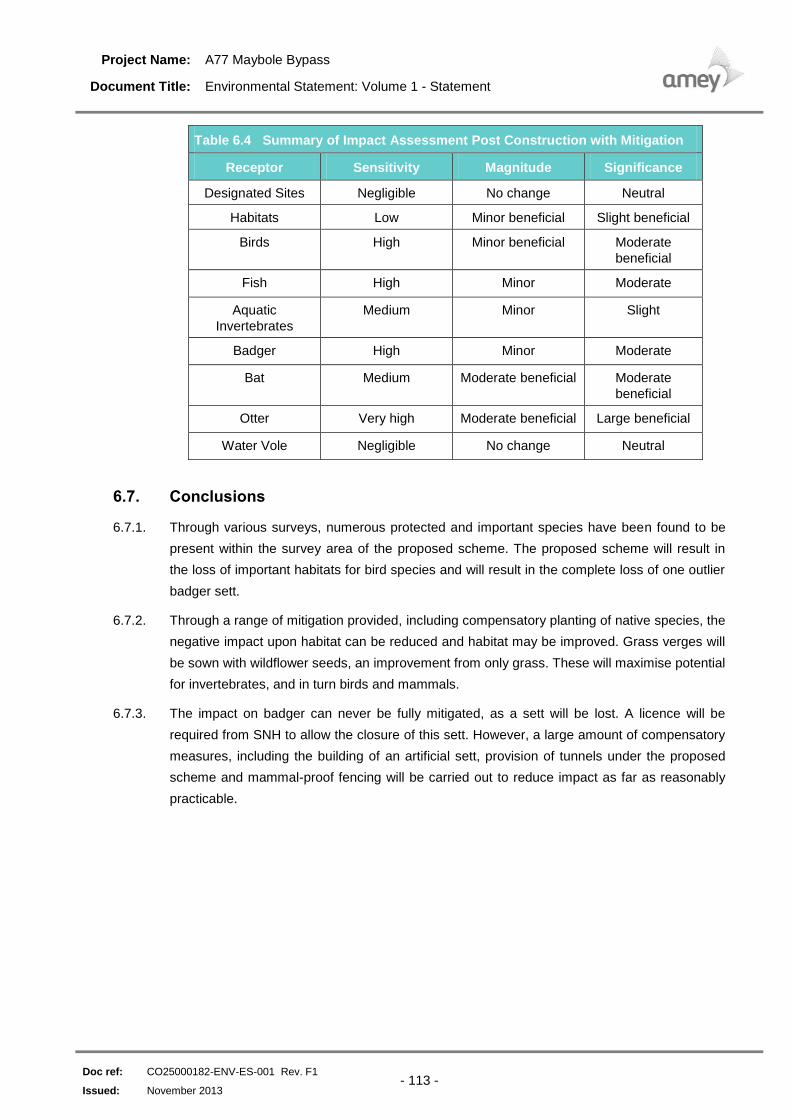
Summary of Impact Assessment Post Construction with Mitigation Table 6.4
Receptor Sensitivity Magnitude Significance
Designated Sites Negligible No change Neutral
Habitats Low Minor beneficial Slight beneficial
Birds High Minor beneficial Moderate
beneficial
Fish High Minor Moderate
Aquatic
Invertebrates
Medium Minor Slight
Badger High Minor Moderate
Bat Medium Moderate beneficial Moderate
beneficial
Otter Very high Moderate beneficial Large beneficial
Water Vole Negligible No change Neutral
6.7. Conclusions
6.7.1. Through various surveys, numerous protected and important species have been found to be
present within the survey area of the proposed scheme. The proposed scheme will result in
the loss of important habitats for bird species and will result in the complete loss of one outlier
badger sett.
6.7.2. Through a range of mitigation provided, including compensatory planting of native species, the
negative impact upon habitat can be reduced and habitat may be improved. Grass verges will
be sown with wildflower seeds, an improvement from only grass. These will maximise potential
for invertebrates, and in turn birds and mammals.
6.7.3. The impact on badger can never be fully mitigated, as a sett will be lost. A licence will be
required from SNH to allow the closure of this sett. However, a large amount of compensatory
measures, including the building of an artificial sett, provision of tunnels under the proposed
scheme and mammal-proof fencing will be carried out to reduce impact as far as reasonably
practicable.