Embed Size (px)
Citation preview

6-1
INTRODUCTION
The Downtown Phoenix Urban Form Project emerged from the principles and priority themes acknowledged in the Downtown Phoenix: A Strategic Vision and Blue Print for the Future. To assist in the implementation of the Strategic Vision, two components were identified: the Downtown Phoenix Plan and the Form-Based Code.
The Downtown Phoenix Plan contains the vision, goals and policies for Downtown as identified through a public process. In order to shape the vision into reality, the Plan’s policies must be translated into zoning standards. This chapter introduces Form-Based Codes, the new character zones for downtown, and the elements that are contained in the code.
FORM-BASED CODE
The Form-Based Code will be the new zoning code for downtown—the implementation tool that will guide development, shape future growth, and help realize the city’s vision for a livelier, more integrated and sustainable downtown. The goals and policies contained in the previous chapters are incorporated and unified into a code that is designed for urban environments.
Zoning and Urban Form Standards6
July 2, 2008

DOWNTOWN PHOENIX PlAN
6-2
PROPOSITION 207
The Downtown Plan and the Form-Based Code have been prepared in accordance with Proposition 207 that states that new zoning cannot diminish the value of private property. Existing entitlements for building heights, density, and the total amount of development capacity allowed on individual properties will be preserved. While new standards are being proposed, the total package of land use and development standards will ensure equal or greater development capacity compared to that which currently exists.
HISTORIC PRESERvATION DISTRICT
Historic and cultural preservation, along with conservation of unique neighborhoods and development patterns, contribute to community pride, investment and re-development. Among the highest goals is preserving a “sense of place” and recognizing a community’s heritage, values and connection with the past. Because Phoenix is a relatively new city compared to other large cities in the U.S., and it has a large proportion of recently transplanted residents, significant efforts to preserve our limited historic resources are especially important. Older buildings and neighborhoods provide a connection with the past that would otherwise be lost.
Preserving and adapting older structures for re-use provide options for living and working that are becoming increasingly desirable as the city continues to grow. Unique neighborhoods and area characteristics should also be recognized and enhanced, adding to the diversity and vitality of the city. New standards will be created to guide adaptive re-use of existing buildings and for new development when adjacent to historic properties. Renovation of historic buildings will continue to be addressed by the Historic Preservation District Office.
gUIDINg PRINCIPlES
Adopt a Form-Based Code that will reflect the vision of the •Downtown Phoenix Plan as desired by the community for a pedestrian-oriented, dynamic urban residential environment, and vital educational, commercial and employment centers
Comply with Proposition 207, which stipulates that new zoning •cannot diminish the value of private property
Adopt standards that will support, enhance and balance •new development with historic properties and established neighborhoods within the Downtown Urban Form Area.

6-3
6ZONINg AND URBAN FORM STANDARDS
ZONINg DISTRICTS
As downtown redeveloped, the underlying zoning districts remained the same, but overtime, new base zoning and overlay districts were adopted as a response to changing development patterns. The lack of flexibility in the current zoning districts, the inability to address the relationship to the pedestrian environment, and understanding the different layers of regulations have become challenging to developers, architects and the public in general. In order to accommodate mixed-uses and adaptive re-use of single-family dwellings, time consuming administrative processes such as rezoning, variances, use permits and special permits are still part of the course. A new zoning code is required, one that can address the needs of a vibrant mixed-use, pedestrian-friendly, multi-modal transit oriented urban environment, while at the same time respecting and enhancing existing residential neighborhoods.
Each character area was evaluated based on existing uses, anticipated future development, and the long-term vision for downtown, and it was determined that certain areas were not appropriate for rezoning. This is the case for the well established historic neighborhoods of East Evergreen and Roosevelt (north of Roosevelt and south of McDowell), and Grant Park. Central Park and Grand Avenue Gateway have shown interest in learning how compatible mixed-uses and Form-Based Code standards can be specifically designed to help revitalize their neighborhoods while helping to maintain and enhance the existing character of the area. Grand Avenue stakeholders are already meeting with city staff, and a first meeting with Central Park stakeholders has already taken place.
Figure 6-1 shows the existing zoning districts and overlay districts in the Downtown Urban Form area.

6-4
EXISTINg ZONINgFIgURE 6-1
6-5
6ZONINg AND URBAN FORM STANDARDS
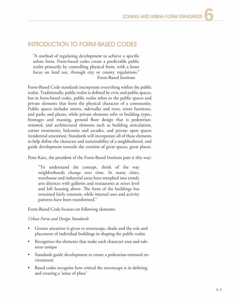
INTRODUCTION TO FORM-BASED CODES
“A method of regulating development to achieve a specific urban form. Form-based codes create a predictable public realm primarily by controlling physical form, with a lesser focus on land use, through city or county regulations.” Form-Based Institute
Form-Based Code standards incorporate everything within the public realm. Traditionally, public realm is defined by civic and public spaces, but in form-based codes, public realm refers to the public spaces and private elements that form the physical character of a community. Public spaces includes streets, sidewalks and trees, street furniture, and parks and plazas, while private elements refer to building types, frontages and massing, ground floor design that is pedestrian-oriented, and architectural elements such as building articulation, corner treatments, balconies and arcades, and private open spaces (residential amenities). Standards will incorporate all of these elements to help define the character and sustainability of a neighborhood, and guide development towards the creation of great spaces, great places.
Peter Katz, the president of the Form-Based Institute puts it this way:
”To understand the concept, think of the way neighborhoods change over time. In many cities, warehouse and industrial areas have morphed into trendy arts districts with galleries and restaurants at street level and loft housing above. The form of the buildings has remained fairly constant, while internal uses and activity patterns have been transformed.”
Form-Based Code focuses on following elements:
Urban Form and Design Standards
Greater attention is given to streetscape, shade and the role and •placement of individual buildings in shaping the public realm.
Recognizes the elements that make each character area and sub-•areas unique
Standards guide development to create a pedestrian-oriented en-•vironment
Based codes recognize how critical the streetscape is in defining •and creating a ‘sense of place’

DOWNTOWN PHOENIX PlAN
6-6
Regulatory Focus and Uses
Form-Based codes de-emphasize density and use regulations in •favor of rules for building form
Form-Based codes emphasize appropriate mixed uses that are •compatible with the neighborhood character, and a mix of hous-ing types, with a focus on building frontages that are human-scale and pedestrian-oriented
Form-Based Code is ultimately a zoning tool and standards will be presented in both diagrams and words, and keyed to a regulating plan that designates the appropriate form and scale (and therefore, character) of development rather than only distinctions in land-use types. Land uses are still addressed, but as complimentary uses to each of the zones that are within the Downtown Urban Form area.
The new Form-Based Code will be a mandatory code (also called a freestanding form-based code) and it will replace most of the existing zoning districts in the Downtown Urban Form Area.
FORM-BASED CODE ElEMENTS
Regulating Plan. Regulating plan maps intensity, form and character rather than simply land uses. Plans designate the locations where different building form standards apply, based on clear community intentions regarding the physical character of the area being code.
Building Form Standards. Regulations controlling the configuration, features, and functions of buildings that define and shape the public realm.
Public Space Standards. Specifications for the elements within the public realm (e.g., sidewalks, travel lanes, on-street parking, street trees, street furniture, etc.).
Administration. A clearly defined application and project review process.
Definitions. A glossary to ensure the precise use of technical terms.
Architectural or Urban Design Standards. Regulations controlling external architectural materials and quality.
Landscaping Standards. Regulations controlling landscape design and plant materials on private property as they impact public spaces (e.g. regulations about parking lot screening and shading, maintaining sight lines, insuring unobstructed pedestrian movements, etc.)

6-7
6ZONINg AND URBAN FORM STANDARDS
lAND USES - MIXED USES
‘Live, work, shop and play’ - all within a five minute walk, or a quick trip on the light-rail. A compatible mix of land uses is a critical element to the sustainability of a vibrant downtown. Urban living requires diversity of places to work, whether they are corporate offices or live-work units. Dining, retail, art galleries, and support businesses need to be in close proximity to and within residential areas to provide urban householders, workers and visitors with a variety services that can meet their everyday needs – without having to drive.
Adaptive re-use is also important and mixed uses are one of the best ways to protect older buildings, and to reinforce the character of a neighborhood. In fact, it is difficult to imagine the Warehouse area without old warehouse buildings and the same can be said for the Roosevelt neighborhood.
Mixed use zones work best when there is a balanced mix of compatible uses, especially on the ground-floor – an important factor in activating the streetscape. A palette of compatible land uses will be developed with guidance from the community, for each Zone, based on use categories that include residential, public and civic, health and support services, commercial (including office) and retail uses.
Roosevelt 217 - Proposed development in the Evans Churchill Zone. A LEED mixed use project with ground-floor commercial uses and residential above. Amenities include terraces on the 2nd and 7th story. Architectural features enhance and mark the intersection as a landmark.
Fate Restaurant on 4th Street, this adaptive re-use project includes two homes (restaurant shown above, bar and gallery shown below)
The bar at Fate Restaurant, in front of the future gallery on 4th Street - the round bar centerpiece is a wrought-iron trellis

DOWNTOWN PHOENIX PlAN
6-8
MIXED USE ZONES
The new Zones and their accompanying Form-Based Code standards reflect the vision, recommendations and policies identified by the community for each of the Character Areas and subareas identified in Chapter 3. The new mixed use zone boundaries mirror those of the character areas and subareas. The existing Downtown Core district will become a new zone and while mixed uses will be standard in all new zones, two different types were developed to reflect zone typology.
Business Core This Zone’s standards are very specific and designed for a high density urban environment. The current DC zoning district already contains some requirements and guidelines and new standards will be developed with a focus on pedestrian-oriented streetscapes.
Figure 6.3 introduces the new downtown zones.
GREEN ROOF-TOPS: SHADE AND SUSTAINABILITY
HIGH DENSITY DEVELOPMENT, BUILDINGS LOCATED AT THE BUILD-TO LINE
PUBLIC SPACES: SHADED PLAZAS ANDCOURTYARDS
DISTINCTIVE CORNER TREATMENTSCREATE LANDMARKS
SHADED SIDEWALKS - STREET TREES AND BUILDING PROJECTIONS
BUSINESS COREFIgURE 6-2

6-9
NEW DOWNTOWN ZONESFIgURE 6-3
ROOSEVELT ST
JEFFERSON ST
JACKSON ST
ADAMS ST
3RD
ST
3RD
AVE
GRANT ST
GRAND AVE
7TH
ST
MC DOWELL RD
BUCKEYE RD
VAN BUREN ST
CEN
TRA
L A
VE
WASHINGTON ST
7TH
AVE
LINCOLN ST
FILLMORE ST
RooseveltLi
ght R
ail C
orrid
or
Townsend
McDowell East Corridor
Evans Churchill
7th
Ave
Cor
ridor
VanBuren
BusinessCore
BioMed
Government
Warehouse
McDowell West Corridor
Park
Nei
ghbo
rhoo
ds
Cor
ridor
AREA
ZONES
No Change in Zoning
Hance Park
Downtown Urban FormZones

DOWNTOWN PHOENIX PlAN
6-10
Downtown Mixed Use (DMU) ZonesDMU zones are designed to replace current zoning districts in established residential neighborhoods and commercial and industrial areas surrounding the Business Core, in close proximity to the Light Rail, and urban in nature. Standards will enhance each zone’s unique identity and character while promoting new development.
DMU zones will apply to the following character areas: Light Rail, Roosevelt, Evans Churchill, BioMedical, Townsend Park, Van Buren, Government and Warehouse.
GREEN ROOFS:SUSTAINABLE STRATEGIES
SHADE TREES AND SETBACKSAS PER NEW STREETSCAPE TEMPLATES
HIGH DENSITY DEVELOPMENTMIXED-USE BUILDINGS - RESIDENTIAL ABOVE,COMMERCIAL USES ON GROUND FLOOR
HEIGHT TRANSITION STRATEGIES SUCH AS SETBACKS & STEPBACKS WHEN ADJACENT TOHISTORIC & SINGLE-FAMILY NEIGHBORHOODS
DOWNTOWN MIXED-USE FIgURE 6-4

6-11
6ZONINg AND URBAN FORM STANDARDS
PRESERVE ALLEYS FOR PARKING ACCESSPARKING AT THE REAR OF BUILDINGS ORUNDERGROUND
HEIGHT TRANSITION STRATEGIES SUCH ASSETBACKS AND STEPBACKS WHEN ADJACENT TOHISTORIC & SINGLE-FAMILY NEIGHBORHOODS
SHADE REQUIREMENTS AND STREET TREES ENHANCE PEDESTRIAN-ORIENTED STREETS
PLAZAS/COURTYARDSVISIBLE AND ACCESSIBLE FROM THE STREET
ARTERIAL STREET
Mixed Use CorridorsDowntown’s mixed use corridors are the Parks Neighborhood, McDowell West, McDowell East, and 7th Avenue. The corridor zone has been identified by having certain elements in common:
Commercially zoned single street corridors•
Located on wide arterial streets•
Abutting existing and well established single-family residential •neighborhoods, but lacking services to meet residents’ daily needs.
MIXED-USE CORRIDOR (MUC)FIgURE 6-5
DOWNTOWN PHOENIX PlAN
6-12
DOWNTOWN URBAN FORM REgUlATINg PlANS
Downtown zoning and overlay districts are complex and existing entitlements for height and density sometimes cross zone boundaries, therefore an adaptation of the Form-Based Code was needed, and regulating plans for density and height were added.
DOWNTOWN REgUlATINg PlAN
The Downtown Regulating Plan identifies the new mixed-use zones and existing zoning districts and overlays that will remain in place. The new Zones will be regulated by three form-based coding systems: building types and frontages, streetscapes, and pedestrian active streets - not all zones will require all types. Due to downtown’s existing conditions, individual streetscape standards and building typology will not be shown on this plan. Instead, they will be created as individual templates for each zone. Figure 6-6 shows the proposed Downtown Regulating Plan
DENSITy REgUlATINg PlAN
The density limits that exist are those governing the units per acre allowed for residential development. There are no density limits for the Business Core and for the Warehouse mixed use zones - height, build-to lines and setback limits will determine the intensity of residential development. While most existing density limits are to remain, key areas were identified for density increases that are more appropriate to urban development. Existing and proposed density limits are shown on Figures 6.7 and 6-8.
HEIgHT REgUlATINg PlAN
Building heights in Downtown are a combination of the zoning districts, overlay zoning regulations, and the height limits established by the Sky Harbor Airport Zoning Ordinance. Greater building heights may be allowed in some zones through height waivers as approved by City Council, and in the Warehouse district, an increase from eighty to one hundred and forty feet may be allowed when conservation easements are provided, or higher, with City Council approval.
Key areas were identified for height increases that are more appropriate to urban development. Existing and proposed height limits are shown on Figures 6-9 and 6-10.

6-13
FIgURE 6-6 DOWNTOWN REgUlATINg PlAN
ROOSEVELT ST
JEFFERSON ST
JACKSON ST
Arts, Culture,
Small Business Overlay
7TH
ST
MC DOWELL RD
BUCKEYE RD
VAN BUREN ST
CEN
TRA
L A
VE
WASHINGTON ST
7TH
AVE
LINCOLN ST
FILLMORE ST
Capitol MallOverlayDistrict
Central City South Interim Overlay District
Roosevelt Neighborhood SPD
Stor
y N
eigh
borh
ood
SPD
Transit OverlayDistrict (TOD-1)
CoronadoNeighborhood
SPD
East Buckeye Road Overlay District
Airport NoiseImpact Zone
Overlay
URBAN FORM AREA
HISTORIC PROPERTY
ZonesEvans Chruchill
Roosevelt South
Townsend
Van Buren
Bio Med
Downtown
Light Rail Corridor
Government
Warehouse
7th Ave Corridor
McDowell East Corridor
McDowell West Corridor
Park Neighborhoods Corridor
ZONING
A-1
A-2
C-1
C-2
C-3
C-O
C-O/G-O
P-1
P-2
R-2
R-3
R-4
R-4A
R-5
R1-6
UR
ZONING OVERLAY
LegendR4-A
NOTE: Airport Height Overlaycovers entire map area.

6-14
FIgURE 6-7 EXISTINg DENSITy lIMITS
ROOSEVELT ST
JEFFERSON ST
JACKSON ST
7TH
ST
MC DOWELL RD
BUCKEYE RD
VAN BUREN ST
CEN
TRA
L A
VE
WASHINGTON ST
7TH
AVE
LINCOLN ST
FILLMORE ST
URBAN FORM AREA
ZONES
Existing DensityNo Residential Permitted
Requires Use Permit
Density not established
10
14.5
22
29
43.5
97
218
No Density Limit
Legend
Residential Permitted
Residential Permitted

6-15 PROPOSED DENSITy lIMITSFIgURE 6-8
ROOSEVELT ST
JEFFERSON ST
JACKSON ST
7TH
ST
MC DOWELL RD
BUCKEYE RD
VAN BUREN ST
CEN
TRA
L A
VE
WASHINGTON ST
7TH
AVE
LINCOLN ST
FILLMORE ST
URBAN FORM AREA
CHARACTER AREA
Proposed DensityNo Residential Uses
Requires Use Permit
10
14.5
22
29
43.5
60
97
125
218
No Density Limit
City Park
Legend
Residential Permitted
Residential Permitted
Height and developmentstandards determine density

6-16
EXISTINg HEIgHT lIMITSFIgURE 6-9
ROOSEVELT ST
JEFFERSON ST
56
4048
48
65
48
250
48
40
30
30
30
3060
60
40
30
258
48
233
250
30
30
283
56
56
40
30
583
30
450
30
30
56
30
60
65
48
30
56
30
383
250
558
40
533
40
508
40
483 408433458
48
80-140
40
65
250
450
30
30
30
48
700700
48
250
250
225
30
30
80-140
7TH
ST
MC DOWELL RD
BUCKEYE RD
VAN BUREN ST
CEN
TRA
L A
VE
WASHINGTON ST
7TH
AVE
LINCOLN ST
FILLMORE STURBAN FORM AREA
CHARACTER AREA
Existing BuildingHeight

6-17 PROPOSED HEIgHT REgUlATINg PlANFIgURE 6-10

DOWNTOWN PHOENIX PlAN
6-18
URBAN DESIgN STANDARDS
“Uses may change over time, but the building will endure.”
Form-Based Code Institute
This simple statement carries a tremendous message. New buildings, whether they are 5, 10, 20 or more stories in height, are permanent improvements that remain in place for many years. Building design at the street-level, and for the first four stories, is a critical factor if the vision of a vibrant and successful Downtown Phoenix is to become an enduring reality, and if the ideals of the Connected Oasis are to be fulfilled.
Although shade is a vital component for the success of Downtown, pedestrian active streets are as well - vibrant restaurants and retail business will eventually line Downtown streets, but they’ll only exist if development provides commercial square footage at ground floor.
Building frontages and parking structures that lack active uses at street level and are mostly blank walls, and corner buildings without enhancements that mark the intersection as a landmark do not attract the attention of visitors and do not enhance Downtown as a urban metropolis. Buildings that have blank walls and non-descript facades will remain that way as long as the buildings stand.
Downtown Phoenix must become a destination for all, whether they are conventioneers or tourists in town for a few days, winter visitors, college students, residents, or downtown workers. As the population grows, new retail will emerge: trendy boutiques, galleries, restaurants, bars, wi-fi accessible cafes, including bike shops and other uses that cater to students, and to residents, workers, and visitors as well. If those attractions are not in Downtown, students, especially, will be able to get on the light rail and go to Downtown Tempe. Urban design standards should guide development towards a future where pedestrian-oriented streetscapes with active ground floor uses and building designs that enhance the public realm are the norm, not the exception.
PHASE II - PUBlIC MEETINgS AND WORkSHOPS
Input from the community is vital in order to create compatible urban design standards and strategies. Building on the foundation of previous public and stakeholder meetings, a new series of public meetings and workshops will take place in each of the character areas. Stakeholders and residents will work with staff to refine the vision and to review the proposed goals for their neighborhoods.

6-19
6ZONINg AND URBAN FORM STANDARDS
URBAN DESIgN CATEgORIES
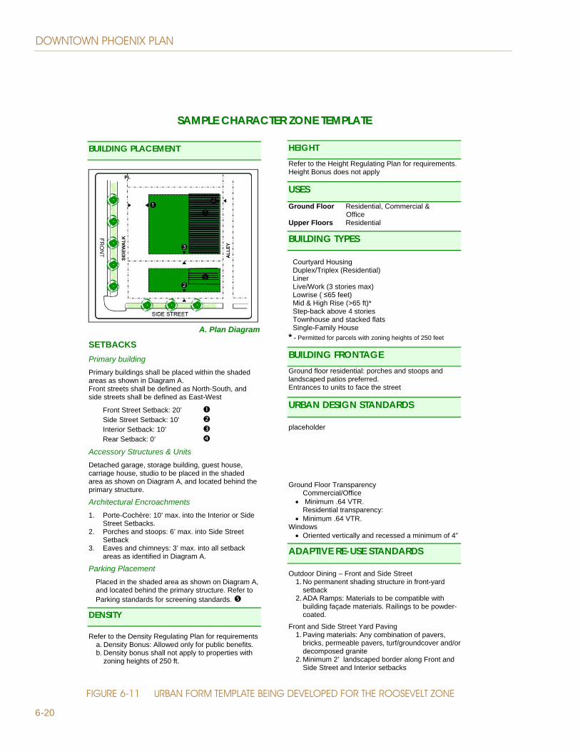
TransitionsUrban design standards will replace standard zoning requirements , but unlike conventional zoning requirements that can be lengthy and difficult for the average person to read, form-based codes standards will be graphically presented. Maintaining established front yard setbacks and height transition between low and high-density development are key issues identified by stakeholders and residents. Height transition standards when abutting historic and single-family neighborhoods, and standards for all setbacks will be shown as diagrams and illustrations, along with parking placement and other standards that may include building types and frontages. Figure 6-11 illustrates a sample template being developed with the guidance from stakeholders and residents from each character area.
Building Typology
Types and FrontagesBuilding types are generic building forms that are used to describe buildings with common form and characteristics and, along with compatible building frontages, provide a method for understanding the existing or desired character of an area or neighborhood. High-risers and towers are building types commonly found in high density areas such as the Business Core, while live-work and low-rise condos are more compatible in residential neighborhoods.
The right frontage types enhance the existing character of a neighborhood and help create a pedestrian-oriented streetscape. Common frontage types such as arcades and galleries, are well suited to urban centers such as the Business Core, while porches and stoops are the trademarks of the Roosevelt and Central Park neighborhoods.
A palette of compatible building types and frontages will be developed for certain zones, and it will provide an array of choices for the developer, while at the same time, helping to reinforce the zone’s character along with a unified streetscape design that is appropriate to the scale, land use, and character of specific streets. Building Massing The massing of individual buildings, including height, bulk and scale, is a critical element in order to ensure that buildings are not overly bulky or massive and do not limit air flow. Long building masses can restrict air movement, which is an essential factor to removing heat radiating from buildings and streets.
Portland Place on Moreland Street. An appropriate interior setback helps create a transition between old and new, while making space for both. A professional office in a renovated single-family home shares the street with a new 4-story condo duplex
DOWNTOWN PHOENIX PlAN
6-20
SSAAMMPPLLEE CCHHAARRAACCTTEERR ZZOONNEE TTEEMMPPLLAATTEE
BUILDING PLACEMENT
A. Plan Diagram
SETBACKS Primary building Primary buildings shall be placed within the shaded areas as shown in Diagram A. Front streets shall be defined as North-South, and side streets shall be defined as East-West
Front Street Setback: 20’ Side Street Setback: 10’ Interior Setback: 10’ Rear Setback: 0’
Accessory Structures & Units Detached garage, storage building, guest house, carriage house, studio to be placed in the shaded area as shown on Diagram A, and located behind the primary structure.
Architectural Encroachments 1. Porte-Cochère: 10’ max. into the Interior or Side
Street Setbacks. 2. Porches and stoops: 6’ max. into Side Street
Setback 3. Eaves and chimneys: 3’ max. into all setback
areas as identified in Diagram A.
Parking Placement Placed in the shaded area as shown on Diagram A, and located behind the primary structure. Refer to Parking standards for screening standards.
DENSITY
Refer to the Density Regulating Plan for requirements a. Density Bonus: Allowed only for public benefits. b. Density bonus shall not apply to properties with
zoning heights of 250 ft.
HEIGHT Refer to the Height Regulating Plan for requirements. Height Bonus does not apply
USESGround Floor Residential, Commercial & Office Upper Floors Residential
BUILDING TYPES
* - Permitted for parcels with zoning heights of 250 feet
Courtyard Housing Duplex/Triplex (Residential) Liner Live/Work (3 stories max) Lowrise ( 65 feet) Mid & High Rise (>65 ft)* Step-back above 4 stories Townhouse and stacked flats Single-Family House
BUILDING FRONTAGE Ground floor residential: porches and stoops and landscaped patios preferred. Entrances to units to face the street
URBAN DESIGN STANDARDS
placeholder Ground Floor Transparency
Commercial/Office Minimum .64 VTR. Residential transparency:
Minimum .64 VTR. Windows
Oriented vertically and recessed a minimum of 4”
ADAPTIVE RE-USE STANDARDS
Outdoor Dining – Front and Side Street 1. No permanent shading structure in front-yard
setback 2. ADA Ramps: Materials to be compatible with
building façade materials. Railings to be powder-coated.
Front and Side Street Yard Paving 1. Paving materials: Any combination of pavers,
bricks, permeable pavers, turf/groundcover and/or decomposed granite
2. Minimum 2’ landscaped border along Front and Side Street and Interior setbacks
FIgURE 6-11 URBAN FORM TEMPlATE BEINg DEvElOPED FOR THE ROOSEvElT ZONE

6-21
6ZONINg AND URBAN FORM STANDARDS
gROUND FlOOR DESIgN
Streets lined with shop-windows and displays, murals, public art, and landscaping are some of the visual trademarks of a vibrant downtown. Ground floor design and articulation standards guide the creation of pedestrian oriented spaces and lively business districts by providing facade requirements that enhance the streetscape, provide a sense of safety, and invite pedestrian activity.
Transparency and EntrancesThe connectivity between the public and private realms is enhanced by the maximization of window and door transparency on the ground floor and commercial entrances directly from the sidewalk. Door and window transparency add “eyes on the street”, thereby increasing natural surveillance.
Primary commercial and business entrances should face the street, especially when streets have been identified as active pedestrian. Whenever possible, developers should provide as many active entrances directly from the sidewalk as possible in order to enrich the pedestrian experience and promote commerce.
For residential development, privacy strategies are needed when units face the street. A landscape area or patio should be created as a buffer zone, or street facing units should be elevated a minimum of three-feet from street grade for privacy.
Corner TreatmentsBuildings located at street intersections should be designed to mark the intersection as a landmark, focal points or gateways. This landmark or gateway image helps create a ‘sense of place’ and enhances the public realm – it is quite common to provide someone with directions by using buildings as landmarks. Standards for building and storefront entrances should include clearly defined entryways by the use of architectural details, change in materials and colors, pop-outs and/or recessed entrances in addition to the minimum shade requirements.
Building ArticulationBuilding articulation refers to the many street frontage design elements, both horizontal and vertical, that help enhance a pedestrian-oriented streetscape. The appropriate scale for articulation is often a function of the size and type of building, and the streetscape – skyscrapers developed at the build-to line tend to have less articulation than a mixed use residential development. Ground floor building articulation and architectural treatments that carry over the first four stories are
Residential uses on the ground �oor must be a minimum 10 feet from back of sidewalk; or there must be a minimum 3 foot grade separation between residential �oor level and sidewalk.
10 ft
3 ftParking
Residential
Residential
Residential
Street
Windows above eye levelof pedestrians protectsresidents’ privacy.
Residential
Residential
Residential
Street
Landscaped setbackprotects residents’privacy.
Residential
Residential
RESIDENTIAl PRIvACyFIgURE 6-12
Artisan Village on Portland and 7th Street. Residential units are designed to appear as single homes, well-articulated, and facades that are oriented to the street with patios for residential privacy.

DOWNTOWN PHOENIX PlAN
6-22
critical in creating an active streetscape that provides visual interest and a sense of place. The importance of articulation on the upper stories of a building varies with the height of the building. Although skyscrapers usually include important design elements on the top stories, this type of articulation does not contribute to the streetscape or the pedestrian experience.
Blank Walls
Streets with long stretches of blank walls are not pedestrian friendly, do not provide a sense of safety, and without natural surveillance (eyes on the street), the area is invitation for vandalism and graffiti. In order to create a pedestrian-friendly environment, the length and percentage of blank walls on street frontages should be limited.
PARkINg
Parking standards are critical to the success of Downtown. Based on policies identified in Chapter 5, new urban standards for vehicle parking and loading will reflect a more pedestrian oriented environment.
New urban design standards will reduce the visual impact of multi-level above-ground parking structures, by addressing the need for screening, active uses on the ground floor, and architectural facades that are compatible with a pedestrian-oriented streetscape. Urban standards will also assist in the development of smaller sites and small scale retail, and adaptive re-use of older buildings by providing appropriate parking exemptions.
As Downtown emerges as a transit-oriented environment, the need bicycle parking is already a reality. New bicycle parking standards will address short and long-term parking in all new developments, including standards for showers in office buildings.
FIgURE 6-13BlANk WAll STANDARDS
40’
20’
Blank WallsMaximum 40% building frontageMaximum 20 ft; 40 ft with art, window displays, or special landscape treatments
Long-term bicycle lockers at the 3rd Avenue Garage
Artisan Village residential garages accessed from the alley

6-23
6ZONINg AND URBAN FORM STANDARDS
SUSTAINABIlITy
Sustainability is a key element in the Plan, and there are sustainable design strategies that can be incorporated in new development and in adaptive re-use that can assist in reducing radiant heat and optimizing thermal comfort at the street level.
Strategies as simple as adding water features, trellises, and partially shading plazas/courtyards and west facing windows can increase thermal comfort. Adding shade elements to windows, providing green walls and rooftop terraces, and incorporating solar panels on rooftops helps minimize energy use.
Permeable concrete and interlocking pavers provide a sustainable alternative to paving. Permeable materials offer the durability of standard concrete while reducing the amount of untreated runoff discharging into storm sewers, and directing water to tree roots and landscaping; their light color and open-cell structure reduce the urban heat-island effect because pervious concrete pavements don’t absorb and store heat like a typical asphalt surface.
PUBlIC SPACES AND RESIDENTIAl AMENITIES
Creating a series of connected outdoor public spaces is a critical component of the Connected Oasis. From courtyards and plazas to outdoor cafes, to mezzanine and rooftop terraces, these spaces become destinations, the gathering places that are a fundamental part of urban living. Public spaces and residential amenity standards will be incorporated into the Form-Based Code and will provide guidance for new development in achieving the vision of the Connected Oasis.
Sustainable strategy: Window screening at City Hall provides shade on the west side of the building
2nd Avenue north of Van Buren. Where palm trees are required, trees should be planted to provide shade.

DOWNTOWN PHOENIX PlAN
6-24
SHADE
Phoenix-SCAPE (Shade & Comfort Activate the Pedestrian Environment)Shade, either as street trees or man-made structures, is the key factor that connects all the elements in the public realm and invites the pedestrian to explore, in comfort, the many attractions and businesses that downtown has to offer. A minimum shade requirement of 75% should be required if downtown is to become the Connected Oasis, and standards should apply to new and existing development.
STREETSCAPE
Pedestrian-oriented streetscapes are a key element in achieving the vi-sion of the Connected Oasis. In preparation of the Form-Based Code typical street typologies will be created for street in Downtown.
Street trees play a major part in the enhancement of pedestrian-oriented streets, but not all species are appropriate for all streets, and failure to thrive occurs due to narrow planting strips, trees being clipped by trucks, the wrong species for the location, and finally, lack of appropriate maintenance and pruning. A new palette of street trees will be created to address the unique conditions of urban streets. New streetscape templates will includes a palette of street trees appropriate for each street, recommended planting strip types, and build-to lines.
Unlike traditional zoning ordinances, Form Based Codes incorporate individual streetscapes as diagrams. The following page demonstrates what these diagrams may look like.
Buchanan and 1st Street. Landscaping grate styles and size can vary. Street trees do better when larger grates are provided.
The Missing Shade
In the foreground is the shaded sidewalk at Focaccia Fiorentina, but shade was not incorporated as part of the remodel for the business to its south, which is also a restaurant.
Roosevelt Character Area 2ns Avenue looking south

6-25
6ZONINg AND URBAN FORM STANDARDS
varies
BUILD-TO LINE 6’ Planting Strip &Shade Structure over 8’ sidewalk
*
15’ M
in.
22’ 22’
6’
25’ M
in.
BL PL 0-10’ 8’
8’ sidewalkvaries
PL BL 8’ 4’ 4’ 4’ 4’
8’ sidewalk
SHADE STRUCTURE (CANOPY OR AWNING) MAY EXTEND A MAXIMUM OF 8’ INTO ROWBALCONIES, 3RD FLOOR AND ABOVE MAY EXTEND A MAXIMUM OF 8’ INTO ROW
MUST COVER ENTIRE 8’ SIDEWALK WIDTH.
MINIMUM 6’ OF SIDEWALK CLEARANCE
OUTDOOR DINING AREA
Gallery & Arcade Build-to Line
OPTIONAL OVERHANGS
INTO ROW - BAY WINDOWS &
BALCONIES
OPTIONAL RECESS OR
ARCADE
BUILDINGS MUST BE BUILT ON OR CLOSE TO THE PROPERTY LINE
SOUTH
NORTH
SECTION
SECTION
SAMPlE OF A STREETSCAPE TEMPlATE TO BE INClUDED IN THE FORM-BASED CODEFIgURE 6-14

DOWNTOWN PHOENIX PlAN
6-26
DEvElOPMENT REvIEW PROCESS
BASIC REvIEW PROCESS
The basic premise of the new zoning is to establish the desired uses and form for Downtown development. Applications for projects should be reviewed relatively quickly and easily through the development review process, and should not require rezoning. Allowances for some exceptions have been incorporated into the new code to allow for a degree of flexibility.
Requests for Additional Height or DensityThe new Downtown zones establish parameters and criteria related to requests for additional building height or density. Minor height increases may be requested through the use permit process, provided that the height increase does not exceed 10 percent of the maximum height allowed in the district. Requests for additional height (above the 10 percent), residential density, and/or increased lot coverage, may only be approved by the City Council upon recommendation of the Planning Commission, and only if the project offers at least one of the following four public benefits:
Preservation and adaptive reuse of a historic building•
Public Parks•
Affordable Housing•
Public Parking•
LEED Certified Projects•
Green Roof/Green Sky Roof•
Incubator Space for Small Businesses and Artists•
Requests for Exceptions to Land Use Regulations or Urban Form StandardsRequests for exceptions beyond those built into the new zoning code are considered in different ways, based on the degree of exception.
Use PermitsUse permits should be required for situations where the city wants to allow some degree of flexibility in the application of development standards (not including density, height, or lot coverage) to account for unique site conditions. Precise findings to this effect should be written in the Form-Based Code and be required in order to approve the use permit.

6-27
6ZONINg AND URBAN FORM STANDARDS
Variances A variance application is required in cases where the city has established a standard, and will allow exceptions only in unique and unusual situations that involve substantial hardship. Findings that demonstrate that a proposed project meets the test for a variance are required.
Rezoning RequestsDue to the mixed-use nature of the new downtown zones and level of flexibility contained in the new Form-Base Code standards, the need to rezone will be minimized, but when needed, property owners may request a rezoning of their property by applying to the Planning Department.
Requests to Revert to Prior Existing ZoningProperty owners may request a reversion to prior zoning districts if they can demonstrate that the new Downtown zoning meets the test established in Proposition 207 of a government action that diminishes property value.
Policies:
Adopt a Form-Based Code for the new zones in the Policy 6-1 Downtown Phoenix Plan that incorporates urban standards
Develop standards that will support, enhance and Policy 6-2 balance new development with historic properties within the Downtown Urban Form Area
Comply with Proposition 207, which stipulates that Policy 6-3 new zoning cannot diminish the value of private property
Develop a palette of compatible lands uses for each Policy 6-4 mixed use zone
Incorporate urban standards in the Form-Based Code Policy 6-5 that will achieve the vision of the Connected Oasis
Incorporate standards in the Form-Based Code that Policy 6-6 address the sustainable strategies