Embed Size (px)
Citation preview

September 2002 North Otaki to Peka Peka Road 37
6.0 Northern Section (Bypass of Otaki)
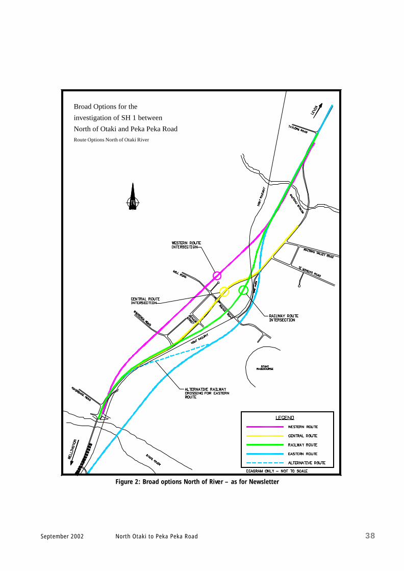
This section of the report describes each option, considers how well it meets the scheme objectives, and reviews the preliminary assessment of environmental effects. A comparative evaluation is made of each option. For the purpose of this report the word bypass is used to describe the separation of local and highway traffic as identified in the scheme objectives (Section 1.3). Four alternative route options were investigated to bypass Otaki , in order to limit the extent of land required to accommodate the highway. A solid median barrier (NJ type) is proposed to divide the highway, to limit the effect on the higher property values within the urban area. The options are illustrated in Figure 2 and individually shown on foldout A3 pages at the end of each subsection. The routes are generally described running from north to south.
6.1 Do Minimum
This option would maintain the existing highway route through Otaki, including lane configurations, pa rking arrangements and the roundabout at the Mill Road/Rahui Road/State Highway 1 intersection. The highway would continue to operate as a two-lane two-way urban arterial route, with a high rate of local and highway traffic interaction. Accidents would at least increase at the same rate as the expected traffic growth (3% p.a.), and driver frustration would follow the same pattern. The Do Minimum option would not meet most of the scheme objectives, as shown in the following table.
Scheme Objectives Compli ance
a ) Safe and efficient FAIL b) Four lane median divided expressway FAIL c ) Minimise/eliminate access FAIL d) Separate local and through traffic FAIL e ) Utilise existing highway PASS f) Minimise adverse effects Not Considered g) Staging opportuni ties Not Applicable Table 8 Do Minimum Option Compliance With Scheme Objectives The Do Minimum option was not considered further in this scheme assessment, except as a basis for comparison in the economic analysis.
September 2002 North Otaki to Peka Peka Road 38
Broad Options for the
investigation of SH 1 between
North of Otaki and Peka Peka RoadRoute Options North of Otaki River
Figure 2: Broad options North of River – as for Newsletter

September 2002 North Otaki to Peka Peka Road 39
6.2 Central Route
The central route option would involve improving the State Highway through Otaki, along the existing alignment. State Highway 1 through Otaki runs in a severely restricted corridor through the business area. The corridor measures 19.4m between shop fronts. The appropriate cross -sectional requirement for the four- lane road is 19.1m; meeting this requirement would leave no additional space to accommodate shop access and pedestrian or local vehicle movement. Developing this corridor to meet the study objectives (e.g. limit access, separate local and through traffic) would require the entire business area along the existing highway to be dismantled and relocated. The geometric alignment of the existing route also include curves with radii of 280m and 100m within the 50 km/h speed zone, and two curves of respectively 300m and 280m radius within the 100 km/h zone south of Taylors Road. These curves are all well below the desired standards for highway alignments. The following table shows that it is not possible to improve the state highway through the town of Otaki and meet the scheme objectives.
Scheme Objectives Compliance
a ) Safe and efficient FAIL b) Four lane median divided expressway FAIL c ) Minimise/eliminat e access FAIL d) Separate local and through traffic FAIL e ) Utilise existing highway PASS f) Minimise adverse effects FAIL g) Staging opportunities Not Applicable
Table 9 Central Route Compliance With Scheme Objectives It would not be appropriate to completely dismantle and relocate the Otaki business area when there are other and better options available. It was therefore decided not to further develop or investigate this alignment as a viable project option.

September 2002 North Otaki to Peka Peka Road 40
6.3 Western Route (Option NW)
6.3.1 Route Description
Refer to the foldout A3 map on page 42. The western route would follow a straight line between the existing SH 1 alignments to the north and south of the town of Otaki. It would extend the existing SH 1 alignment at Taylors Road (south-easterly direction) in a straight line, curve slightly westwards after crossing the Waitohu Stream over a new bridge, and continue in a straight line parallel to Dunstan Street across the market garden area east of the Otaki College. It would then curve slightly ea st south of Waerenga Road, and join the existing highway alignment at the Otaki River Bridge. The Mill Road intersection would be grade-separated. The cliff that runs to the north of and parallel to Mill Road provides sufficient elevation to make an underpass possible and accommodate Mill Road. Mill Road would continue to be the main link to Otaki Beach. The final development of this route would require a new four -lane bridge over the Waitohu Stream, as well as two additional two-lane bridges over the Otaki River. A parallel local road would link Addington Road to Otaki’s Main Street, including a separate Otaki River Bridge. The existing bridge would be upgraded along with a new two- lane bridge to form the expressway. The following left turns would link SH 1 and the local road network: • Northbound access, northbound egress and southbound egress at Mill Road
• Southbound access at Riverbank Road
• All movements at Addington Road/Otaki Gorge Road.
Vehicles travelling in each direction would be able to leave the highway and rejoin it on the other side of the Otaki Railway commercial area.

September 2002 North Otaki to Peka Peka Road 41
6.3.2 Compliance with Scheme Objectives
This option would generally comply with the scheme objectives.
Scheme Objectives Compliance
a ) Safe and efficient PASS b) Four lane me dian divided expressway PASS c ) Minimise/eliminate access PASS d) Separate local and through traffic PASS e ) Utilise existing highway PASS1 f) Minimise adverse effects FAIL2 g) Staging opportunities PASS
Table 10 Western Route Compliance With Scheme Objectives Notes 1 The existing highway would be used as a local road. 2 Refer to the following assessment of effects on the environment. 6.3.3 Preliminary Assessment of Environmental Effects
A preliminary assessment of the environmental effects of this option has been made for traffic noise and vibration, landscape, land use, social severance and business impact. The key points are summarised below (full reports are included as Appendices H to L).
6.3.3.1 Traffic Noise and Vibration (Refer to Appendix H)
The traffic survey for Otaki (refer Appendix A) indicates that approximately 35% of highway traffic is destined for Otaki. This traffic would continue to use the existing route irrespective of the new highway route. The new western route would therefore move appr oximately 65% of the highway traffic and associated traffic-induced environmental effects closer to the Dunstan Street residential area and Otaki College. This would result in a dramatic increase in ambient noise levels at these locations. In three of the four areas where noise levels were monitored, the increase in traffic-associated noise is predicted to exceed Transit New Zealand’s recommended upper limits. Noise barrier fences (or other mitigating measures) would be required. The western route is not expected to result in any noticeable vibration effects for nearby houses.
WESTERN ROUTE
NORTHERN SECTION
(OPTION NW)

September 2002 North Otaki to Peka Peka Road 42
6.3.3.2 Landscape (Refer to Appendix I)
There are extensive farmland areas between Taylors Road and the Waitohu Valley Road. The land is generally flat, and includes both sand dunes and p eatlands. Between Waitohu Valley Road and Mill Road the route would pass well behind developed properties , across open pastoral land. The existing dunes offer opportunities to integrate the highway and provide the elevation needed for the road to pass over the railway l ine. South of Mill Road the route would pass through the back of dwellings and across market gardens , before joining the road over Otaki River Br idge. This would replac e open areas between dwellings with a four -lane highway. The western route could be accommodated without major adverse effects on the landscape.
6.3.3.3 Land Use (Refer to A ppendix J)
The northern section of the western route passes through a rural area, and may affect the agricultural value of the properties. Further south , the route would displace many Otaki Central houses. It would also pass through a 40 ha area identified by Kapiti Coast District Council as a future growth zone, and adversely a ffect i t s development potential (the area is west of the existing highway, to the north of Mill Road). When the land use effects of the five different Otaki Bypass options were evaluated, the western route ranked fourth – the land use impact and effect on the land’s future potential were considered severe.
6.3.3.4 Social Severance (Refer to Appendix K)
This route effectively severs the existing commercial centre from the rest of Otaki . I t removes easy east -west travel for local traffic by channelling movement through the new Mill Road highway underpass, and increases east -west travelling times. Vehicles, pedestrians and cyclists would all have to use the Mill Road underpass to reach ei ther the highway or the commercial centre. A number of existing roads, including Waerenga Road, would be closed. The social severance consequences of the western option were considered to be serious.
WESTERN ROUTE
NORTHERN SECTION
(OPTION NW)

September 2002 North Otaki to Peka Peka Road 43
6.3.3.5 Business Impacts (Refer to Appendix L)
This option proposes accessing the highway north and south of the main business area. Businesses would still be accessible “en-route”, as road users would not leave their dire ction of travel. The direct exposure of businesses along State Highway 1 in Otaki would, however, reduce by approximately 65%. The Otaki Traffic Survey (Appendix A) indicates that approximately 6% of vehicles travelling north/south through Otaki stop for less than 30 minutes , and would include ‘pass -by trips’ or impulse shopper s. The potential impact of the western route on local businesses is not known – any loss of business could, for example, be more than offset by the trend of continued urban growth in the Kapiti District . Marketing practices would have to change if the businesses could no longer rely on direct exposure in order to attract customers. Businesses in Otaki would, however, have many years to adjust to any forthcoming change in their environment. When the business impacts of the different Otaki Bypass options were evaluated, the western route ranked second worst. 6.3.4 Construction of the Route
Approximately 80% of the route between Taylors Road and the new Mill Road intersection/underpass could be completed with no disruption to highway travel. The section south of Mill Road and the closure of Waerenga Road would, however, severely affect local east -west travel. The Mill Road underpass is the only local road tha t would have to be constructed to maintain local traffic movement. Construction phasing could be: • Complete the section of the highway from Taylors Road to directly north of Mill
Road (including the new underpass).
• Construct the new Otaki River Bridge, and the section from Mill Road to directly north of the final tie- in to the existing highway, at the same time.
• Complete the tie -ins to the existing highway and the local access roads for individual properties .
WESTERN ROUTE
NORTHERN SECTION
(OPTION NW)

September 2002 North Otaki to Peka Peka Road 44
Advantages and Disadvantages
The advantages of the western option are : ( i ) the existing state highway would stay open during construction
( i i ) SH 1 would become a local access route, with few additional local roads required
( i i i ) the business area along the existing highway would remain
(iv) a limited number of dwellings would be displaced
(v) i t would be compatible with options on both the eastern and western side of the railway line to south of the Otaki River
(v i ) i t would use the existing Otaki River Bridge.
The disadvantages are: ( i ) the community’s exposure to traffic noise would increase
( i i ) the western side of the town would be cut off from the business community along SH 1
( i i i ) i t would have a major environmental impact on Otaki College and the affected residential areas of Dunstan Street, Waerenga Road and SH 1 (north of Riverbank Road)
(iv) the route would effectively divide the township .
WESTERN ROUTE
NORTHERN SECTION
(OPTION NW)

September 2002 North Otaki to Peka Peka Road 46
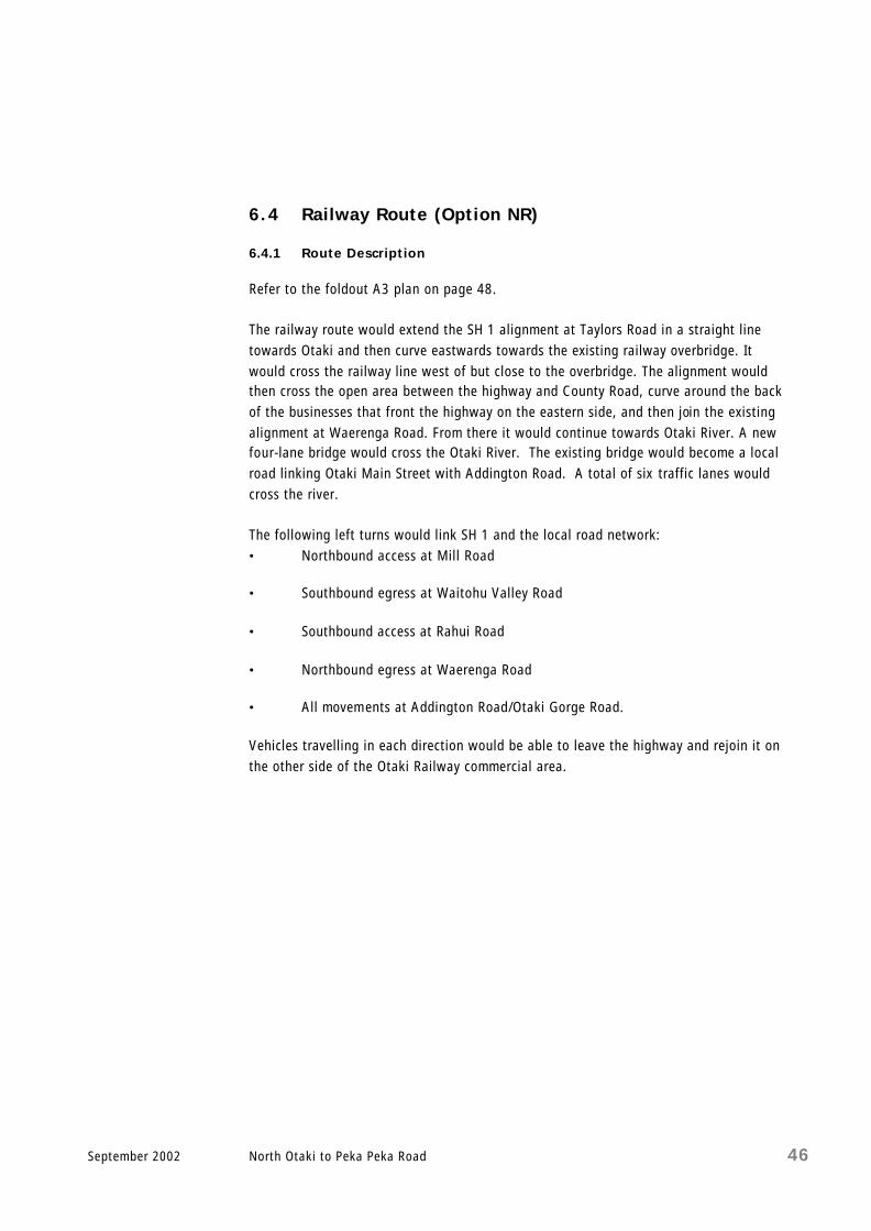
6.4 Railway Route (Option NR)
6.4.1 Route Description
Refer to the foldout A3 plan on page 48. The railway route would extend the SH 1 alignment at Taylors Road in a straight line towards Otaki and then curve eastwards towards the existing railway overbridge. It would cross the railway line west of but close to the overbridge. The alignment would then cross the open area between the highway and County Road, curve around the back of the businesses that front the highway on the eastern side, and then join the existing alignment at Waerenga Road. From there it would continue towards Otaki River. A new four-lane bridge would cross the Otaki River. The existing bridge would become a local road linking Otaki Main Street with Addington Road. A total of six traffic lanes would cross the river. The following left turns would link SH 1 and the local road network: • Northbound access at Mill Road
• Southbound egress at Waitohu Valley Road
• Southbound access at Rahui Road
• Northbound egress at Waerenga Road
• All movem ents at Addington Road/Otaki Gorge Road.
Vehicles travelling in each direction would be able to leave the highway and rejoin it on the other side of the Otaki Railway commercial area.

September 2002 North Otaki to Peka Peka Road 47
6.4.2 Compliance with Scheme Objectives
This option would comply with the scheme objectives.
Scheme Objectives Compliance
a ) Safe and efficient PASS b) Four lane median divided expressway PASS c ) Minimise/eliminate access PASS2 d) Separate local and through traffic PASS e ) Utilise existing highway PASS1 f) Minimise adverse effects PASS g) Staging opportunities PASS
Table 11 Railway Route Compliance With Scheme Objectives Notes 1 The existing highway would be used as a local road. 2 This would involve significant impact on properties fronting SH 1 north of
Riverbank Road . 6.4.3 Preliminary Assessment of Environmental Effects
A preliminary assessment of the environmental effects of this option has been made for traffic noise and vibration, landscape, land use, social severance and business impact. The key points are summarised below (full reports are included as Appendices H to L).
6.4.3.1 Traffic Noise and Vibration (Refer to Appendix H)
The railway route would relocate the highway between Taylors Road and Rahui Road to pastoral land, further away from residential dwellings than the existing highway. Between Rahui Road and Waerenga Road the route would travel behind the line -developed business area east of the existing highway, and would have limited positive traffic associated effects for residents. Between Waerenga Road and the Otaki River it would use the existing highway corridor. The wider highway in this section would move traffic and therefore traffic noise marginally closer to residential dwellings. The northern third of the railway route would decrease traffic noise for t he community. The middle third would have minimal effect, and the southern third would increase the community’s exposure to highway noise. The southern third is the most densely populated area along the railway route. Based on the number of residential properties that would be affected, the overall community exposure to traffic noise, and potentially vibration, would increase.
RAILWAY ROUTE
NORTHERN SECTION
(OPTION NR)

September 2002 North Otaki to Peka Peka Road 48
6.4.3.2 Landscape (Refer to Appendix I)
The section of the railway route between Taylors Road and Rahui Road would pass across open pastoral land at the back of developed properties that offers few landscape constraints. The secluded setting of these properties would be affected, and while mitigation would reduce the effects the character of the area around these houses would be altered. South of Rahui Road the route would pass along the back of the existing businesses, and join the existing highway corridor at Waerenga Road. The houses that lie directly along the railway route would need to be removed, but the land is otherwise suited t o the development of a highway. Any major effects would be constrained between the existing highway and the railway line, while the available open space would help mitigate the highway’s impact on the landscape. Between Waerenga Road and the Otaki River B ridge the railway option could be accommodated without major adverse effects on the area’s character.
6.4.3.3 Land Use (Refer to Appendix J)
This route would pass through low-density residential, some commercial and many rural areas. It would displace a large proportion of existing residential activities and force the relocation of some businesses. An on-ramp would pass close to the front of the Otaki Railway Station, and the theatre building is also likely to be affected. The route would have an impact on the commercial value of the rural land and limit its pastoral use. When the different Otaki Bypass options are evaluated in terms of their displacement of existing land uses and effect on the future potential of the land, the railway option is ranked in the middle – neither one of the best nor one of the worst options in terms of land use. While it takes advantage of a narrow corridor between the commercial centre and the railway line, it cannot be accommodated without significant displacement of bui ldings and activities.
6.4.3.4 Social Severance (Refer to Appendix K)
The majority of this route is adjacent to the existing rail corridor. The proposals for local road connections would effectively retain the connections between the northern, eastern and western sections of the township, while retaining the at -grade rail crossing at Rahui Road. This route has little more social severance effect than the existing state highway through Otaki.
RAILWAY ROUTE
NORTHERN SECTION
(OPTION NR)

September 2002 North Otaki to Peka Peka Road 49
The small increase in social severance would be due to the elevation of the road (for the underpass) creating a visual barrier, and the greater difficulty residents would have accessing the railway station.
6.4.3.5 Business Impacts (Refer to Appendix L)
This option proposes accessing the highway north and south of the main business area. Businesses would still be accessible “en-route”, as road users would not leave their direction of travel. Access to the business area for northbound drivers would be straightforward, while southbound drivers would have a more circuitous route. The railway route alignment would reduce the direct exposure of the businesses along State Highway 1 in Otak i by approximately 65%. The Otaki Traffic Survey (Appendix A) indicates that approximately 6% of vehicles travelling north/south through Otaki stop for less than 30 minutes , and would include ‘pass -by trips’ or impulse shoppers. The potential impact of the western route on local businesses is not known – any loss of business could, for example, be more than offset by the trend of continued urban growth in the Kapiti District . Marketing practices would have to change if the businesses could no longer rely on direct exposure in order to attract customers. Businesses in Otaki would, however, have many years to adjust to any forthcoming change in their environment. When the business impacts of the different Otaki Bypass options were evaluated, the railway route ranked in the middle – neither one of the best nor one of the worst options. 6.4.4 Construction of the Route
The construction of the section between Taylors Road and the railway could be completed with little effect on local or highway travel. The local road underpass and new local roads would need to be constructed before the existing railway overbridge was demolished. Construction phasing could proceed as follows: • Complete the section of the highway north of the railway, including the tie -in at
Taylors Road.
• Complete the local road underpass and the section of highway behind the existing businesses.
• Re-route traffic onto the new local network at R ahui Road while completing the new railway overbridge, link to the new northern section.
RAILWAY ROUTE
NORTHERN SECTION
(OPTION NR)

September 2002 North Otaki to Peka Peka Road 50
• Re-route traffic onto the new highway system north of Rahui Road while completing construction of the section south of Waerenga Road.
6.4.5 Advantages and Disadvantages
The advantages of this option are: ( i ) It would use approximately 30% of the existing highway corridor through Otaki.
( i i ) It would be compatible with options on both the eastern and western side of the railway line to the south of the Otaki River.
( i i i ) It would use the existing Otaki River Bridge.
The disadvantages are: ( i ) It would have a severe impact on the area along the existing highway south of
Waerenga Road.
( i i ) It would increase the community’s exposure to traffic noise.
( i i i ) It would directly affect businesses at the souther n end of the commercial area.
(iv) It would relocate the railway station.
RAILWAY ROUTE
NORTHERN SECTION
(OPTION NR)


September 2002 North Otaki to Peka Peka Road 52
6.5 Eastern Route (Option NE)
6.5.1 Route Description
Refer to the foldout A3 plan on page 56. Three eastern options were developed: • Eastern Outer
• Eastern Inner
• Eastern Improved.
The Eastern Outer route met the minimum 900m radii requirement of the Geometric Design Manual. The Eastern Inner route did not meet the minimum 900m radii but did have radii suitable for a 110 km/h design speed. The Eastern Inner had less effect on the County Road residential area. During the preliminary assessment of environmental effects a further route was identified that minimised the effects on the adjacent areas by relocating the railway. This was also confirmed in the Option Evaluation Workshop (see Section 7.0). Cost estimates for these options are shown below.
Option Land Cost Construction Cost Total Eastern Outer $7.3 M $42.8 M $50.1 M Eastern Inner $7.7 M $40.0 M $47.7 M Eastern Improved $3.6 M $41.7 M $45.3 M
Table 12 Cost Estimates for Eastern Routes in Northern Section Given the similar costs and the significantly reduced adverse effects on the community for the Eastern Improved Option, the Eastern Outer and Eastern Inner Options were not progressed further . The Eastern Improved route would extend the existing SH 1 alignment at Taylors Road in a straight line towards Otaki, then curve eastwards towards the existing railway overbridge. The railway line would be relocated to keep the route on the eastern side of the rail corridor. The route would curve westward and cross Rahui Road to the west of County Road. It would then curve eastwards towards the Otaki River where the alignment would remain on the eastern side of the rail corridor, and cross the river with a new four -lane bridge located east of the existing rail bridge. Rahui Road would no longer cross the railway line. Road users would follow County Road and the old highway to access the commercial area.

September 2002 North Otaki to Peka Peka Road 53
The existing Otaki River Bridge would become a local road linking Addington Road/Otaki Gorge Road with Main Street. The existing railway overbridge would be replaced with a new bridge spanning both the rail and the new highway, in a location slightly south of the existing overbridge. It would form the major local link between Otaki North and the rest of the township. The following left turns would link SH 1 and the local road network: • Southbound egress at Waitohu Valley Road
• Northbound access at County Road
• Southbound access at Rahui Road
• All mo vements at Addington Road/Otaki Gorge Road.
Drivers travelling north or south would be able to leave the new highway and rejoin it on the other side of the Otaki Railway commercial area. 6.5.2 Compliance with Scheme Objectives
This option would comply with the scheme objectives.
Scheme Objectives Compliance
a ) Safe and efficient PASS b) Four lane median divided expressway PASS c ) Minimise/eliminate access PASS d) Separate local and through traffic PASS e ) Utilise existing highway PASS1 f) Minimise adverse effects PASS g) Staging opportunities PASS Table 13 Eastern Route Compliance With Scheme Objectives Notes 1 The existing highway would be used as a local road. 6.5.3 Preliminary Assessment of Environmental Effects
A preliminary assessment of the environmental effects of this option has been made for traffic noise and vibration, landscape, land use, social severance and business impact. The key points are summarised below (full reports are included as Appendices H to L).
EASTERN ROUTE
NORTHERN SECTION
(OPTION NE)

September 2002 North Otaki to Peka Peka Road 54
6.5.3.1 Traffic Noise and Vibration (Refer to Appendix H)
The Eastern Improved route would relocate approximately 65% of the highway traffic and associated noise to a green fields location. Modest decreases in traffic noise would occur at many existing residential sites on the west of the existing highway between Otaki River Bridge and Mill Road, due to the road moving further east from these houses. Noise decreases would also occur at sites located to the northeast of the township, in the Waitohu Valley and Te Manuoa Road areas. There would be modest increases for a small number of houses near Rahui Road, although most of these houses could be taken for the project if this alignment was adopted. Overall, the relocation of the highway would result in reduced exposure of the community to traffic n oise and vibration. The Eastern Improved option has the most overall traffic noise benefits.
6.5.3.2 Landscape (Refer to Appendix I)
The Eastern Improved route arose from the landscape assessment of the other routes. Figure 3.41 (refer next page) Landscape Assessment from the report (Appendix I) clearly indicates that the route with the least effect on the landscape would follow the railway route north of Rahui Road and the eastern route south of Rahui Road. The section of the eastern improved route between Tay lors Road and Rahui Road would pass across open pastoral land at the back of developed properties that offers few landscape constraints. While it would change the character of the landscape, there is sufficient space and scale to mitigate this with replanting. South of Rahui Road there are few landscape constraints, and the route would not significantly alter the character of the area.
EASTERN ROUTE
NORTHERN SECTION
(OPTION NE)


September 2002 North Otaki to Peka Peka Road 56
6.5.3.3 Land Use (Refer to Appendix J)
The eastern improved route has emerged as a possible optimal route through Otaki. In terms of land use displacement it seeks to exploit the narrow open spaced corridor through the town and therefore minimise displacement of more intensive activities. A fundamental part of this option is the reali gnment of the railway to the east, forming a shorter and easier curve from just south of the station to south of the Waitohu Stream. The shorter distance, faster and safer curve and removal of the Rahui Road at grade rail crossing are all significant bene fits to rail, offsetting any construction inconvenience. The station would need to be moved west about 10 metres (or the opportunity taken to consider a more favourable location to the south). The only buildings that would be displaced are the railway st ation, seven houses on floodable land in Rahui Road and farm buildings west of the existing railway overbridge. Local road connections and the ramps on and off the highway would also avoid major displacement of land uses. The existing highway link into O taki from the north would be retained and would cross over both the expressway and the repositioned railway. County Road would form an important east -west link, as Rahui Road would be severed. Any upgrade could be accommodated without adversely impacting on residents to the east, as redundant railway land would be available on the west side. A southbound on-ramp adjacent to the former dairy factory could be accommodated without major impacts on that building, and a northbound on-ramp could be located just north of the new rail bridge, without further effects on land use. The effects on rural land and pastures could be mitigated successfully. In terms of land use, the Eastern Improved option is significantly superior to all the others.
6.5.3.4 Social Severance (Refer to Appendix K)
The majority of this route would be adjacent to the existing rail corridor, resulting in one north/south division through Otaki rather than two. The proposals for local road connections effectively retain the connections between the northern, eastern and western sections of the township, although it only provides a single grade separated access across the rail corridor. This single connection would result in slightly longer local travel between Otaki Racecourse and the rest of the township, although the separation of local and highway traffic would result in less traffic conflict and reduced waiting times at the larger intersections.
EASTERN ROUTE
NORTHERN SECTION
(OPTION NE)
September 2002 North Otaki to Peka Peka Road 57
The grade -separation of local and highway traffic would result in safer local travel (because of reduced highway traffic interaction), as well as safer pedestrian access. Pedestrian access at Rahui Road could be further enhanced by the provision of a rail and highway overpass at the existing location.
6.5.3.5 Business Impacts (Refer to Appendix L)
This option pr oposes accessing the highway north and south of the main business area. Businesses would still be accessible “en-route”, as road users would not leave their direction of travel. Access to the business area for northbound drivers would be straightforward, while southbound drivers would have a more circuitous route. The railway route alignment would r educe the direct exposure of the businesses along State Highway 1 in Otaki by approximately 65%. The Otaki Traffic Survey (Appendix A) indicates that approximately 6% of vehicles travelling north/south through Otaki stop for less than 30 minutes , and would include ‘pass -by trips’ or impulse shoppers. The potential impact of the western route on local businesses is not known – any loss of business could, for example, be more than offset by the trend of continued urban growth in the Kapiti District . Marketing practices would have to change if the businesses could no longer rely on direct exposure in order to attract customers. Businesses in Otaki would, however, have many years to adjust to any forthcoming change in their environment. The eastern improved option would have the least direct impact on business in Otaki. Only two businesses would be displaced. 6.5.4 Construction of the Route
The eastern i mproved route could be constructed with little effect on local or highway travel. The local access across the new highway and railway would need to be built before demolition of the existing rail overbridge and relocation of the railway. Construction coul d be phased as follows: • Construct the new combined rail/future highway overbridge.
• Temporarily relocate highway traffic onto the new overbridge.
• Relocate the railway, provide a temporary rail crossing at Rahui Road.
• Construct the new highway and the Otaki River Bridge.
• Open the highway and close the temporary rail crossing at Rahui Road.
EASTERN ROUTE
NORTHERN SECTION
(OPTION NE)
September 2002 North Otaki to Peka Peka Road 58
6.5.5 Advantages and Disadvantages
The advantages of this option are: ( i ) It reduces the community’s exposure to traffic noise
( i i ) It would not directly affect the business area along the existing highway
( i i i ) It separates highway and local traffic in Otaki efficiently
(iv) The highway would not cross the railway line
(v) Ease of construction
(v i ) It affects a relatively small number of residential properties
(v i i ) It uses the existing Otaki River Bridge as a local road.
The disadvantages are: ( i ) It is not easily compatible with options on the western side of the railway line to
the south of the river.
( i i ) It would require approval from Tranz Rail.
EASTERN ROUTE
NORTHERN SECTION
(OPTION NE)


September 2002 North Otaki to Peka Peka Road 60
6.6 Staging
6.6.1 General
I t is possible to stage the northern section options as two- lane roads rather than four-lane roads. The expected traffic volume (AADT) on the bypass in 2015 would be approximately 14,000 vehicles, based on a 65/35 split. A two- lane highway would be sufficient for this volume. This report does not recommend reducing the geometric standard or permitting temporary access to the route with the first stage. The options have been designed to avoid access and to provide a grade -separated link between the commercial area of Otaki and other sections of the town. If access is permitted, or the grade separation compromised, there would be two effects: the highway would be less safe due to right -turning traffic movements; there could be public pressure to make the highway more accessible. The concept of an expressway passing Otaki could be lost. It is also not recommended that the options be staged at County Road/SH 1. Staging at this location would create substandard geometrics, not in keeping with a high-speed highway alignment. The effects of the first stage of the options would be very similar to the fully developed route as they are on the same alignment. 6.6.2 Staging Effect
The western, railway and eastern options could all be staged, with the first stage involving a two-lane bypass of Otaki. This stage would provide all the advantages of splitting local and highway traffic, but would eventually have to be upgraded to accommodate larger traffic volumes. The staging of each option would result in savings related to the construction of the road, as the initial stage would include most of the earthworks and structures, as well as buying properties. They would be constructed as one of the carriageways of the four- lane highway. The carriageway first constructed should be closest to the most developed areas, to minimise the difficulty of constructing the second stage. Savings due to two lane structures for the Otaki River and Waitohu Stream crossings would be significant. The complete grade -separated intersection would have to be constructed north of Mill Road, and would not offer savings as a first stage option.

September 2002 North Otaki to Peka Peka Road 61
It would also be possible to introduce a sub-stage for the western and railway options. This substage would join the highway north of the Otaki Bridge and thereby avoid the duplication of the bridge at the outset.
6.7 Staging Comparison
The first stage of three likely options were considered in the economic analysis, to determine whether staging would have a significant effect on the choice of option. • Eastern
The interim stage of the eastern improved route involves a two-lane arrangement along the alignment. It includes grade separation at Mill Road/Rahui Road and a second Otaki River Bridge upstream of the Rail Bridge.
• Western (with a second Otaki River Bridge)
The interim stage of the western route involves a two- lane arrangement along the alignment and grade separation at Mill Road/Rahui Road. It would include a second Otaki River Bridge.
• Western (without a second Otaki River Bridge)
Same as above, without a second Otaki River Bridge. This option was developed to show the economic effect of being able to defer the construction of a second Otaki River Bridge. There would be a significant merge delay crossing the river and route security would still be less than desirable, given the single bridge crossing of the Otaki River.
The economic effects analysed for these options do not warrant revising the choice of option. It is not appropriate to select a strategic route effectively based on when to provide a second crossing of the Otaki River. It would be better to defer the project until the economics of the right option are justified.