Embed Size (px)
Citation preview
COUNCIL 25. 10. 2012 PLANNING COMMITTEE 3. 10. 2012
- 18 - 6. NORTH WEST REVIEW AREA
General Manager responsible: General Manager Strategy and Planning, DDI 941-8281
Officer responsible: City Planning Unit Manager
Author: Mark Stevenson, Senior Planner
PURPOSE OF REPORT 1. This report seeks the adoption of recommendations which propose that the North West Review
Area, defined in Attachment 1, is rezoned as part of the District Plan review to a special ‘Rural-Urban Fringe’ zone or similar. The intention is to provide for the ongoing use of the area for rural activities and to maintain the natural and physical resources of the NWRA while enabling certain compatible activities to establish. The recommendations also propose that staff be directed to prepare a plan change for rezoning specific areas for industrial business activities within the NWRA to enable development to proceed ahead of the rezoning of the balance of the North West Review Area. It is also recommended that a separate parallel plan change is prepared to provide a framework of objectives and policies for the Special Purpose (Airport) zone (SPAZ) in the City Plan and a review is undertaken of the rules including activities permitted within the SPAZ. In doing so, consideration will be given to the appropriateness of enabling a wider range of industrial activities in Dakota Park, which forms part of the airport zone.
EXECUTIVE SUMMARY 2. The North West Review Area (NWRA) is an area of approximately 860 ha situated between the
airport and the City’s western urban edge as shown on Attachment 1. The area currently provides for rural activities and acts as a buffer between the airport and residential areas. The NWRA comprises natural and physical resources of significance to the City including groundwater aquifers that provide water supply to the City, and high quality soils.
3. A review of the area’s function and future land uses arose from the Commissioners
recommendations and the Regional Council's decisions on Proposed Change 1 (PC1) to the Regional Policy Statement, which concluded that it was not an “appropriate resource management treatment to leave this (defined in Attachment 1) land exclusively as rural land over the next 35 years”. The decisions on PC1 were on the basis that the economic use of the soils in the NWRA is compromised. The area was therefore identified as a ‘Special Treatment Area’ (‘STA1’) within the urban limits in PC1 with a requirement for specific analysis to be undertaken to determine the appropriate land uses for the area. The Council lodged an appeal on this aspect of PC1 and sought that it be identified outside the urban limits, with provision for up to 100ha of business land. The area was subsequently described as the ‘North West Review Area’ and defined outside the urban limits in Chapter 12A of the Regional Policy Statement, made operative the Minister of Earthquake Recovery in October 2011. Chapter 12A also identified scope for up to 100 ha to be identified for business use in the NWRA, following a review of the area. Under Chapter 12A, the 100 ha would be deemed to be within urban limits upon the completion of a review of the area without a change to the Regional Policy Statement.
4. While the outcomes of the appeals to the Environment Court on PC1 and Court of Appeal on
Chapter 12A will determine whether the NWRA is within or outside the urban limits, both documents require a review of the area to be undertaken. It is considered necessary to review the area’s function and appropriate land uses given its strategic location between the airport and urban area, the natural and physical resources in the area, and the need for business land in this part of the City.
5. The majority of the NWRA is currently zoned Rural 5 (Airport Influences Zone) and Rural 3
(Styx-Marshland Rural zone) in the City Plan. These zones provide for productive uses such as intensive horticulture that utilises the highly productive soils in the area. The PC1 decision signalled that the current zoning provisions may no longer be appropriate.
64
COUNCIL 25. 10. 2012 PLANNING COMMITTEE 3. 10. 2012
- 19 - 6 Cont’d 6. Having regard to the natural resources and the location of the NWRA, its role is considered to
be as an ‘Rural-Urban Fringe’, which the rezoning should reflect. An ‘Rural-Urban Fringe’ zone is usually regarded as the transition zone between urban and rural areas that provides for activities typically associated with an peri-urban area while retaining open space and trees. Activities that are considered appropriate within the NWRA include non noise-sensitive “urban" activities e.g. industrial business activities, formal and informal open spaces, sporting and recreational facilities, in addition to the ongoing use of the area for rural activities and associated dwellings. Residential subdivision, education and health facilities (noise sensitive activities) are not considered to be appropriate in the NWRA, which is within the 50 dBA Ldn airport noise contour that noise sensitive activities are to be avoided in.
7. A report (Attachment 3) on the NWRA that considers the appropriateness of different land
uses concludes that 100 hectares of industrial business land should be identified in the area. This is based on a review of the supply of industrial land and take up of land across the City, which highlights a potential shortfall in supply in the north west of Christchurch. There are also indications of increased demand for industrial land as businesses relocate from other parts of the City, as well as demand for land associated with the rebuild. The location of the NWRA in close proximity to Christchurch International Airport also makes the NWRA attractive for businesses that use air freight and/or have clients/ staff who frequently travel by air. The airport is a significant node of economic activity that will also generate demand for business land in the surrounding area including the NWRA.
8. The NWRA study has identified areas within the NWRA to meet future demand for industrial
land including land between Russley Road and Hawthornden Road, north of Avonhead Park; land north of Wairakei Road between Woolridge Road and Russley Road and north of Waimakariri Road (see Attachment 2). The identification of these areas is on the basis of a number of criteria, which are consistent with promoting sustainable management including urban form, accessibility, the availability of infrastructure, continuity with existing business areas and environmental values amongst other matters. Since a workshop with the Planning Committee held on 21 August, two additional areas have been identified north of Wairakei Road and north of Waimakariri Road, between Harewood Road and Sawyers Arms Road. There has been demand for industrial land associated with the rebuild and relocation of businesses since the earthquakes; and it is necessary to provide sufficient capacity for growth over the next 25 years with certainty.
9. Given the physical proximity of the NWRA to the airport, the assessment of business land
issues, and some identified deficiencies with the existing Special Purposes (Airport) zone framework, it is appropriate to consider possible changes to the Special Purposes (Airport) zone in parallel so as to ensure an integrated resource management approach. The review of the NWRA and airport need to be dealt with in a comprehensive way given the potential for each area to support similar business activities in the future and the issues that need to be considered in planning each area, for example, groundwater and noise. The airport is part of the same geographic context as the NWRA, with a road being the only boundary between the two areas, and is part of the same local economy. The airport is a significant hub of economic activity that generates demand for land in the North West. The potential for Dakota Park (Attachment 4), an existing ‘Cargo and Freight’ zone within the Special Purpose (Airport) zone, to provide for a wider range of industrial business activities has also been considered as part of the report (Attachment 3).
10. Rules in the City Plan currently restrict activities permitted within the Special Purpose (Airport)
Zone to those that are airport related. Since 2009, there have been a number of resource consents granted for non-airport related development within Dakota Park. The Commissioner in the most recent decision on a non-airport related activity in the Special Purpose (Airport) zone has recommended that Council gives some consideration to the cumulative effects of non-airport development on the integrity of the City Plan. In the decisions to date, it has also been highlighted that there are no specific objectives and policies for the Special Purpose (Airport) zone to support the anticipated outcomes for the zone. A letter from CIAL dated 18 September 2012 (Attachment 5) highlights the issues that have emerged and the uncertainty created for CIAL due to the absence of a clear policy framework for the SPAZ.
65
COUNCIL 25. 10. 2012 PLANNING COMMITTEE 3. 10. 2012
- 20 - 6 Cont’d 11. Having regard to the decisions on resource consents for development in Dakota Park, the
precedent these have set and the inappropriateness of an ad-hoc approach to further non-airport related development within the airport zone, staff consider that a plan change is necessary to provide a clear policy framework for managing development in the Special Purpose (Airport) zone. The purpose of the plan change would be to clarify the objectives and policies to ensure that CIAL is not put through consent processes with unnecessary cost and uncertainty.
12. A plan change would also consider the need to amend the rules prescribing the activities
permitted within the SPAZ. Particular consideration would be given to the activities permitted within Dakota Park having regard to decisions on resource consents in this area amongst other matters. As a part of the plan change process, there is a need to consider alternatives and the costs/ benefits of each option. For example, enabling a wide range of non-airport uses in the wider Special Purpose (Airport) zone could significantly reduce capacity in the long term for airport activities that may put development pressure on surrounding rural areas, compromising their productive potential. In the opinion of officers, it would not be sound resource management practice for this matter not to be considered given the investigations into business land and the proximity of the airport to the NWRA.
FINANCIAL IMPLICATIONS 13. Provision has been made in the 2012/13 Annual Plan (District Plan Activity) for funding that will
enable the Council to implement the recommendations of the report on the North West Review Area.
Do the Recommendations of this Report Align with 2009-19 LTCCP budgets? 14. The recommendations align with the 2009-19 LTCCP budgets and other subsequent funding
allocations by the Council. LEGAL CONSIDERATIONS Have you considered the legal implications of the issue under consideration? 15. The North West Area Review is necessary in light of decisions and appeals on Proposed
Change 1 and therefore it is appropriate that the Council consider the appropriate use of the NWRA for the next 35 years. While the review is a precursor to a statutory process under the Resource Management Act, the recommendations are consistent with achieving the sustainable management of natural and physical resources while providing for the social and economic wellbeing of people and communities (purpose of the Resource Management Act).
16. The review of the area has included consideration to promoting the social, economic,
environmental, and cultural well-being of communities and applying consultation principles in accordance with the Local Government Act and purpose of the Resource Management Act.
ALIGNMENT WITH LTCCP AND ACTIVITY MANAGEMENT PLANS Do the recommendations of this report support a level of service or project in the 2009-19
LTCCP? 17. The recommendations directly align with the LTCCP and Activity Management Plan levels of
service. The relevant performance standard in the Activity Management Plan is the development of policy and plans to implement the Council’s component of the Greater Christchurch Urban Development Strategy Action Plan. The relevant priority actions of the UDS Action Plan are to “Undertake strategic land use studies to clarify the potential for business land use in identified parts of Greater Christchurch” and “Make Operative and then give effect to RPS PC1”.
66
COUNCIL 25. 10. 2012 PLANNING COMMITTEE 3. 10. 2012
- 21 - 6 Cont’d
ALIGNMENT WITH STRATEGIES
Do the recommendations align with the Council’s strategies? 18. The review of the NWRA gives effect to Policy 12 in Proposed Change 1 of the Regional Policy
Statement, which identifies the area as a Special Treatment Area that necessitates specific analysis and planning to achieve the sustainable management of natural and physical resources. The recommendations are consistent with the City Plan objectives and policies and other Council strategies and plans by seeking to retain the rural amenity of the NWRA, protect groundwater recharge areas and versatile soils and manage urban growth to avoid adverse effects on these natural resources while ensuring sufficient business land is provided to enable the economic recovery of the City.
CONSULTATION FULFILMENT 19. The Council undertook consultation with land owners, occupiers and interest groups in the
North West Review Area at an initial stage in 2011. Views were sought on the future development potential and types of land use activities sought in this rural-urban fringe location, which have informed the recommendations in the report. There have also been meetings and discussions with stakeholders including the CIAL, New Zealand Transport Agency and landowners.
20. Landowners, whose properties are identified as being appropriate for industrial business use
have recently been consulted and are generally supportive of the proposal. At the time of preparing a plan change, further consultation will be undertaken with landowners and other affected parties in the surrounding area.
21. The land identified for industrial business use between Hawthornden Road and Russley Road
includes an area identified by Council’s Greenspace team for future extension of the Avonhead Cemetery. The Team Leader Asset Network Planning Greenspace has advised that funding has been allocated for future purchase of the land, which will be subject to negotiations with the landowner in the future. At the time of staff preparing a plan change, consideration will be given to the future use of land and it may be necessary for Council to purchase the land to safeguard its potential for use as a cemetery.
22. Land at 711 Johns Road, north of Waimakariri Road, is currently owned by Council as a
reserve for gravel extraction. Part of this site is proposed for an electrical substation under an exchange agreement with Orion. The balance of approximately 14 hectares is to be returned to the Crown in the future, reflecting a previous Council decision. The Property unit has been consulted on the proposed identification of the land for business, which does not affect the exchange processes currently in progress under the Reserves Act.
23. In respect of the Special Purpose (Airport) zone, CIAL support a plan change being prepared to
provide a clearer policy framework for the zone. A letter from CIAL dated 18 September 2012 (Attachment 5) describes the reasons for this position including the uncertainty created by the current provisions for the SPAZ.
24. There has also been a workshop with the Planning Committee, held on the 21st August, to brief
Councillors on the review and the work undertaken to date. Since the workshop, additional areas have been identified for industrial business activities to the north of Wairakei Road and north of Waimakariri Road, between Harewood Road and Sawyers Arms Road. There has been demand for industrial land associated with the rebuild and relocation of businesses since the earthquakes; and it is necessary to provide sufficient capacity for growth over the next 25 years with certainty.
67
COUNCIL 25. 10. 2012 PLANNING COMMITTEE 3. 10. 2012
- 22 - 6 Cont’d 25. Workshops with the Fendalton Waimairi Community Board and Shirley Papanui Community
Board were also held on 18 and 19 September respectively. Both Community Boards have indicated their general support to the review of the NWRA. Further input will be sought from the Boards at the time of preparing a plan change for the areas identified for business and as part of the District Plan Review.
STAFF RECOMMENDATION
That the Council resolve to: (a) Adopt the ‘North West Review Area Report’ dated September 2012 (Attachment 3) and the
recommendations in the report. (b) Direct staff to rezone the North West Review Area to a special ‘Rural-Urban Fringe’ zone as a
part of the District Plan review, with the exception of the those areas subject to recommendation (c).
(c) Direct staff to prepare a Council led plan change to rezone 100 ha for industrial business
purposes in the following areas (refer to Attachment 3):
approximately 15 ha for industrial business purposes at 711 Johns Road, north of Waimakariri Road (Area 1);
approximately 50 ha for industrial business purposes, north of Wairakei Road between Woolridge Road and Russley Road (Area 2) and
approximately 35 ha for industrial business purposes, between Hawthornden Road and Russley Road (Area 3).
(d) Prepare individual Outline Development Plans for the whole of each area identified for business
in Recommendation (c) as a plan change. The Outline Development Plans shall be prepared in accordance with the decisions version of Proposed Change 1 (or Chapter 12A should it be reinstated).
(e) Direct staff to prepare a Council led plan change to provide a clearer policy framework in the
City Plan for the Special Purpose (Airport) zone and to review the rules prescribing activities permitted within the SPAZ with consideration given to enabling a wider range of business activities in Dakota Park (80 ha) (Attachment 4).
COMMITTEE RECOMMENDATION
That the staff recommendation be adopted.
Note: Councillor Wells is a Director on CCHL and as such was concerned she may have a conflict of interest and took no part in this item.
BACKGROUND (THE ISSUES)
Overview of North West Review Area 26. The North West Review Area is located on the north-west edge of Christchurch City. Extending
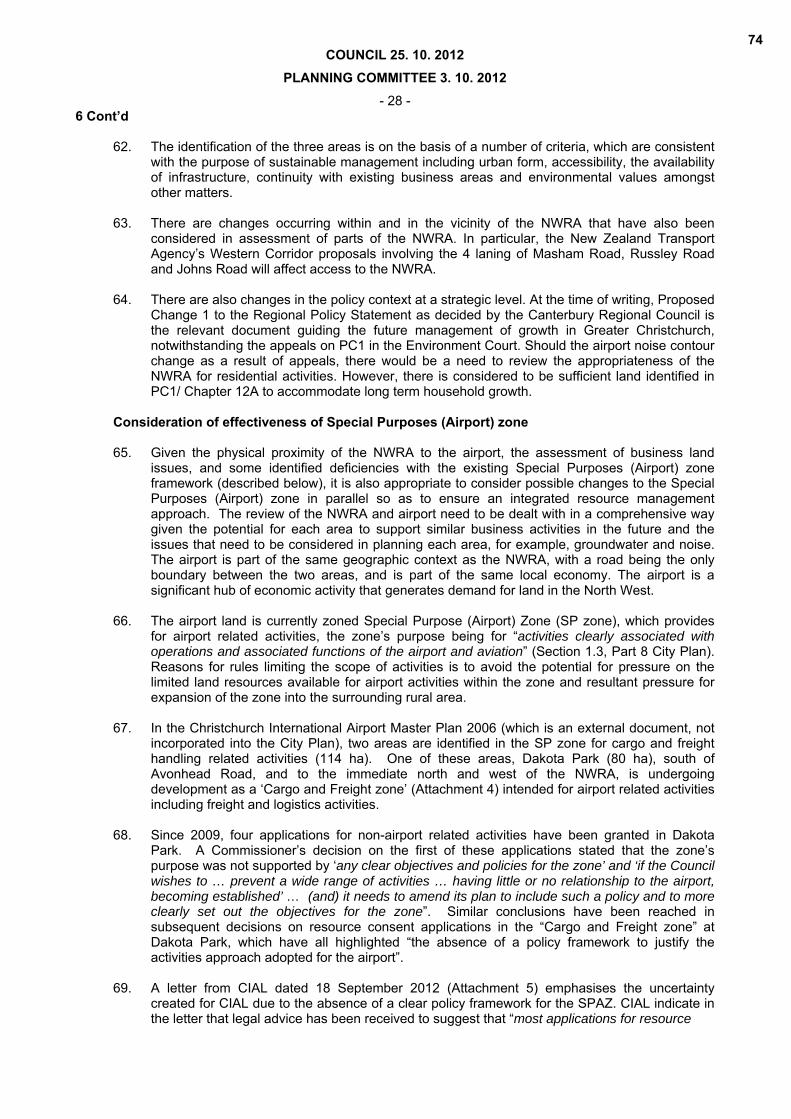
for approximately 10 km along State Highway 1 between Yaldhurst Road in the south and Johns Road adjacent to the Groynes/ Clearwater Resort in the north. The area is a long and relatively narrow strip of land of approximately 860 hectares (See Attachment 1). The location of the NWRA parallel to State Highway 1 and adjacent to Christchurch International Airport contributes to the area’s role as a strategic corridor and gateway to the City.
68

COUNCIL 25. 10. 2012 PLANNING COMMITTEE 3. 10. 2012
- 23 - 6 Cont’d 27. The NWRA is currently used for agriculture, intensive horticulture and rural lifestyle living, an
outcome sought for the area in the City Plan, which zones the majority of the NWRA as Rural 5 (Airport Influences Zone) and Rural 3 (Styx-Marshland Rural zone). These zones provide for productive uses such as intensive horticulture that utilise the highly productive soils in the area. There are also community facilities including a church and school, and clusters of residential properties (approx. 1,000 m2 sections) established through historical subdivision. The City Plan establishes a minimum lot size for subdivision of 4 ha in the Rural 3 and Rural 5 zones, which prevents the creation of additional residential sections in the NWRA.
28. The NWRA contains highly versatile soils, which have inherently high productive values. The
majority of the NWRA has well drained soils and gravels/ hard soils tend to be at a deep level (45 cm or deeper), enabling digging and ploughing for agricultural/ horticultural activities. Some parts of the NWRA continue to support rural activities that utilise the high quality soils, while other areas have reduced capacity given the subdivision that has occurred. The pattern of subdivision has a strong influence on the ability for the natural resource of soils to be utilised and as allotment sizes have reduced, the range of options for productive use of the soils has also reduced.
29. The natural resources of the area are significant in a strategic context. The groundwater
resource beneath the NWRA comprise the most vulnerable parts of the groundwater system due to the unconfined nature of the aquifers. The groundwater resource is the principal source of drinking water for Christchurch City and therefore objectives and policies in the Natural Resources Regional Plan emphasise the importance of protecting this resource. The area also has a number of surface waterways including the Styx River, Smacks Creek and Waimairi Stream, which are vulnerable to contamination from land use changes.
30. The area also provides a buffer between residential areas and Christchurch International
Airport. The area is within the 50 dBA Ldn airport noise contour as defined by Proposed Change 1 to the Regional Policy Statement, within which noise sensitive activities including residential, education and health facilities are to be avoided. This minimises the potential for curfews or other restrictions on the operation and development of the airport while protecting residents from a noisy environment.
31. There has been a history of pressure for rural subdivision and the development of urban
activities in the NWRA. The zoning of the NWRA for urban activities has historically been resisted in planning documents, reflecting the natural and physical resources in the area, proximity to Christchurch International Airport, which is identified in PC1 as “Strategic Infrastructure”, and policies directed towards urban containment and consolidation.
Policy Framework 32. Proposed Change 1 (PC1) of the Regional Policy Statement as recommended by
Commissioners and adopted by the Council in December 2009, provides strategic direction for managing long term growth across Greater Christchurch. It identifies the area now known as the North West Review Area as Special Treatment Area 1, an area requiring investigation and planning to determine its medium to long term role in meeting the Objectives of Proposed Change 1.
33. Decisions on Proposed Change 1 (PC1) concluded that it was not appropriate to leave the area
in exclusively rural use in the long term. This was in recognition of the limitations to economic rural activity in the area including:
the pattern of subdivision being too small to provide a productive base for farming; closure of the produce markets and the inability for rural production in the NWRA to meet
significant demands of supermarkets for example; inability to move heavy farm vehicles and machinery on roads with high traffic volumes; and Reverse sensitivity impacts arising from proximity between rural and urban activities.
69
COUNCIL 25. 10. 2012 PLANNING COMMITTEE 3. 10. 2012
- 24 - 6 Cont’d 34. It was determined that ‘specific analysis and testing should be undertaken to determine the
medium and long-term sustainable future of the area’. The long term future of the area was considered to be in some form of urban activity and was therefore included within the urban limits.
35. Proposed Change 1 was subject to appeals to the Environment Court. An appeal by the
Council related specifically to the NWRA and sought that it be identified outside urban limits with provision for up to 100 ha of business land. The 100 ha would be deemed to be within urban limits following a review. The Regional Council accepted this relief and formally changed its position on this matter from what was set out in the decisions version of PC1. This position continued until the Minister of Earthquake Recovery revoked PC1 and inserted Chapters 12A and 22 into the Operative Regional Policy Statement in October 2011. In Chapter 12A, STA1 was renamed the North West Review Area and was annotated on Map 1 as a Policy 15(f) area. Unlike PC1, the NWRA was outside the urban limits in Chapter 12A, which also identified scope for up to 100 ha to be identified in the NWRA for business use, dependent on the outcome of a review (this Review). A note below Table 3 of Policy 6 in Chapter 12A stated that the area identified for business in the NWRA as a part of the review would be deemed to be within the urban limits.
36. An application for judicial review of the Minister’s decision to revoke PC1 and insert Chapters
12A and 22 into the RPS was lodged and subsequently granted on 24 July 2012. The effect of this ruling was for the Minister’s decision to be set aside and PC1 to be reinstated in the Environment Court meaning all appeals on PC1 continue at this stage.
37. While the High Court’s decision has subsequently been appealed to the Court of Appeal and
there is therefore the possibility of Chapters 12A and 22 being reinstated, the current policy document for managing the future growth of Greater Christchurch and of relevance to the NWRA at the time of preparing this report is the decisions version of Proposed Change 1 December 2009 (It is noted however that this is not the version supported by Environment Canterbury and the UDS Partners as part of the Environment Court proceedings on PC1). This effectively means that the area known as the NWRA is a Special Treatment Area and inside the urban limits. Further, a request to develop a Land Use Recovery Plan has been sent on behalf of all of the UDS Partners to the Minister of Earthquake Recovery. Aspects of that Recovery Plan may involve the NWRA and its implementation, however this is yet to be confirmed.
38. The outcomes of the Courts’ decisions on PC1 and Chapter 12A will determine whether the
NWRA area is within or outside the urban limits and whether the area is a ‘Special Treatment Area’. Regardless, there is a need to review the area’s function and appropriate land uses given its location between the airport and urban area, and the strategically important natural and physical resources in the area including the groundwater aquifers and soils.
39. In establishing the appropriate function of the NWRA and land use activities to be provided for,
an assessment has been undertaken of the existing policy framework. The key points emerging from the review of plans and strategies are as follows:
Development should support the objective of urban consolidation by being contiguous with
existing or proposed residential and business areas Groundwater and surface water quality is to be maintained or enhanced by avoiding
adverse effects of land use changes The natural character of rivers and their margins is to be maintained and enhanced through
the identification and acquisition of land Versatile soils are retained for their productive potential where appropriate Development does not compromise the safe, efficient and effective operation of the
strategic road network Land use activities do not have an adverse effect on the operation and development of
Christchurch International Airport.
70

COUNCIL 25. 10. 2012 PLANNING COMMITTEE 3. 10. 2012
- 25 - 6 Cont’d Consultation 40. The Council undertook consultation with land owners, occupiers and interest groups in the
North West Review Area at an initial stage in the review to inform the analysis of issues and planning of the area’s long term future. Views were sought on the future development potential and types of land use activities sought in this rural-urban fringe location.
41. The key findings from community and stakeholder feedback indicated a desire to retain the
areas’ rural character and amenity, respondents valuing the sense of openness and spaciousness. There was also support for the retention of a buffer between rural/urban activities and residential areas/airport.
42. There was also support for change over the next 30 years with an increase in development
including business activities. The locations considered most appropriate for business were alongside or as an extension of existing business/commercial areas on Wairakei Road or to compliment the existing developments on the Airport land near Russley and Johns Road.
43. While there was recognition of the airport noise contour acting as a constraint to residential
activities, submitters sought a change from the 50 dBA Ldn airport noise contour to a reduced 55 dBA Ldn contour to enable residential development. If the airport noise contour were to change in the future, the appropriateness of the NWRA for residential activities would need to be revisited. However, there is considered to be sufficient land identified in PC1/ Chapter 12A to accommodate long term residential growth.
44. Landowners, whose properties are identified as being appropriate for industrial business use
have recently been consulted and are generally supportive of the proposal. Two properties have been excluded from consideration for this purpose, as the landowners were opposed to the identification of their properties for industrial business use. The two owners are also concerned about the effects on amenity of a business development adjacent to their properties. At the time of preparing a plan change to rezone the surrounding land, there will be further consultation with these landowners. There will also be a need to consider the potential effects of business development on residents and how these effects will be mitigated. This may include requirements for development to be set back a suitable distance from adjoining properties and landscaping.
45. Land identified for industrial business use between Hawthornden Road and Russley Road
includes land to the immediate west of Avonhead Cemetery, which has been identified as a future extension of the cemetery. The Team Leader Asset Network Planning - Greenspace has advised that funding has been allocated for future purchase of the land, which will be subject to negotiations with the landowner in the future. At the time of staff preparing a plan change, consideration will be given to the future use of land and it may be necessary for Council to purchase the land to safeguard its potential for use as a cemetery.
46. Consultation is proposed with affected persons in the surrounding area at an early stage in
preparation of a plan change in accordance with the Resource Management Act. 47. It is also considered appropriate to review the existing Special Purposes (Airport) zone
framework given the investigations into business land and the proximity of the airport to the NWRA. It is apparent from a number of resource consent decisions in this zone that the current plan provisions are deficient and do not enable the zone to achieve its intended purpose. In respect of the Special Purpose (Airport) zone, CIAL has indicated support to a plan change to provide a policy framework for the zone.
Function in the NWRA 48. In recognition of the NWRA’s location between residential areas and the airport, the area
continues to act as a buffer within which noise sensitive activities are to be avoided. This limits the potential for urban activities in the area. Its position between the urban area and airport also makes the NWRA unique relative to other areas on the fringe of the City.
71

COUNCIL 25. 10. 2012 PLANNING COMMITTEE 3. 10. 2012
- 26 - 6 Cont’d 49. As discussed, the NWRA has natural and physical resources of strategic importance including
the groundwater resource, soils and natural features such as the Styx River that originate in the area. The historical use of the area for agricultural and horticultural activities has also given the NWRA a different character to other parts of the City. These values need to be recognised in the development of the NWRA.
50. Having regard to the values of the area and the conclusions on Proposed Change 1, the function of the NWRA is considered to be as a ‘Rural Urban Fringe’, which should be reflected in the zoning of the NWRA. A rural-urban fringe location is often characterised by certain land uses which have either purposely moved away from the urban area, or require much larger tracts of land for example:
Utilities and public facilities e.g. waste transfer stations and recycling facilities recreation and tourism facilities and activities, industries associated with rural produce lifestyle blocks.
51. Despite the presence of these land uses, a rural-urban fringe location remains largely open with the majority of the land in agricultural or other rural use. The proposed zoning would enable activities typically found in a peri-urban area including passive and active open space, and sport and recreational facilities while supporting its ongoing use for rural activities and retaining its openess. Except in locations where business land is proposed, it is not expected that the area will undergo significant change. While the Commissioners on PC1 concluded that its long term use was not exclusively in rural use, there are parts of the NWRA that continue to support rural activities that utilise the high quality soils and continuation of these activities should be provided for. This is reflected in submissions from landowners who sought the continuation of agricultural and horticultural activities in the area.
Assessment of industrial business land to determine the quantum required in the NWRA 52. An assessment has been undertaken of the need for industrial business land in the NWRA.
Chapter 12A as inserted into the Regional Policy Statement by the Minister of Earthquake Recovery identified scope for up to 100 hectares to be identified in the NWRA for business use, which provides a starting point. A review has therefore been undertaken of industrial land supply and demand across the City to determine whether there is a need for additional industrial land.
53. In terms of supply, there was 271 ha of ‘vacant’ (defined as unoccupied by buildings or
designated as road or reserve) zoned land in industrial business zones as at June 2011 (including greenfield areas identified in Chapter 12A that had been rezoned). An additional 164 ha has been rezoned for industrial business purposes since then (Total 435 ha of vacant zone land including areas rezoned up to August 2012).
54. Further analysis of the data indicates that a proportion of vacant land is occupied for storage
and other activities, the actual amount of unutilised land being closer to 300 ha. An additional 285 hectares is identified in chapter 12A of for greenfield business activities in Christchurch City to 2041 including the ‘MAIL’ site at the corner of Russley Road and Memorial Ave (19 ha), which is outside the NWRA. While this indicates a significant supply of industrial business land, there is potential for a shortfall in supply in some parts of the City including the Business 4 zone, a suburban industrial zone intended for light industrial and servicing activities (not heavy industry), and higher amenity Business 4T zone, the technology park off Sir William Pickering Drive, Russley.
55. It is also evident from an assessment of existing and future industrial land supply that some
industrial areas are not suitable for industrial activities that discharge large volumes of wastewater, particularly the south west of Christchurch. There are limitations on the discharge of wastewater in the South West due to the presence of the unconfined aquifer, the need to maintain surface waterways and the distance and associated cost of transporting wastewater to the treatment plant at Bromley, which are also applicable to the NWRA. Demand for land in
72
COUNCIL 25. 10. 2012 PLANNING COMMITTEE 3. 10. 2012
- 27 - 6 Cont’d areas such as the eastern suburbs that enables large volumes of wastewater to be discharged
may result in increased costs for land, forcing dry industries that currently occupy these areas to relocate to areas such as the North West Review Area.
56. There is anecdotal evidence of increased demand for land in the west of the City as businesses
relocate due to earthquake damage. There is also displaced demand expected from the inner suburbs as they reach capacity and undergo change to a mix of uses envisaged in the Central City Plan. It is expected that the rebuild of Christchurch will result in increased demand for land and in the long term, growth is anticipated in the machinery and equipment manufacturing sector. This is demonstrated by Tait Electronics, who already have a strong presence on the edge of the NWRA at Wairakei Road and who propose a plan change to rezone land within the North West Review Area for industrial business purposes. Having regard to the limited quantum of vacant industrial land in the north west and potential demand, there is considered to be a need for additional industrial business land, particularly in the short term. In the longer term, the amount of land provided for needs to be considered within the context of the recovery of the Central City, and the eastern suburbs.
57. A technical report on business land identifies a number of strengths that make the NWRA
attractive for industrial business activities including its location adjacent to and accessible to the strategic road network (SH1 and SH73) and in close proximity to the airport for international markets and airport related business. The airport in particular is a significant node of economic activity that will generate demand for business land in the surrounding area including the NWRA.
58. Other strengths of the NWRA for industrial business activities include:
A number of east west routes providing access to the Central City, suburban centres and other parts of the City;
Existing industrial areas and a Technology Park on Wairakei Road, which could be extended;
Proximity to rural areas with potential demand from industries that depend on rural activities;
Bus routes that can be extended; High levels of amenity for business; and Ability to operate within the airport noise contour which constrains a number of other
activities. Identified areas to accommodate future demand for industrial business land 59. To address the need for additional industrial land, three areas that total 100 ha are identified
within the NWRA as being appropriate for industrial business purposes (see Attachment 1):
Land at 711 Johns Road, north of Waimakariri Road (15 ha); Land north of Wairakei Road between Woolridge Road and Russley Road (50 ha); and Land between Russley Road and Hawthornden Road, north of Avonhead Park (35 ha).
60. The types of activities that are considered to be appropriate in these areas are light industrial
activities providing for high value manufacturing companies (such as Tait Electronics) while retaining open space and trees. This can be achieved through rezoning the identified areas with provisions that retain a sense of openness.
61. There is also a need to avoid activities that may have an adverse effect on groundwater, such
as heavy industrial activities that may use and store a large volume of hazardous substances, while also ensuring adverse effects on the surrounding environment are avoided.
73
COUNCIL 25. 10. 2012 PLANNING COMMITTEE 3. 10. 2012
- 28 - 6 Cont’d 62. The identification of the three areas is on the basis of a number of criteria, which are consistent
with the purpose of sustainable management including urban form, accessibility, the availability of infrastructure, continuity with existing business areas and environmental values amongst other matters.
63. There are changes occurring within and in the vicinity of the NWRA that have also been
considered in assessment of parts of the NWRA. In particular, the New Zealand Transport Agency’s Western Corridor proposals involving the 4 laning of Masham Road, Russley Road and Johns Road will affect access to the NWRA.
64. There are also changes in the policy context at a strategic level. At the time of writing, Proposed
Change 1 to the Regional Policy Statement as decided by the Canterbury Regional Council is the relevant document guiding the future management of growth in Greater Christchurch, notwithstanding the appeals on PC1 in the Environment Court. Should the airport noise contour change as a result of appeals, there would be a need to review the appropriateness of the NWRA for residential activities. However, there is considered to be sufficient land identified in PC1/ Chapter 12A to accommodate long term household growth.
Consideration of effectiveness of Special Purposes (Airport) zone 65. Given the physical proximity of the NWRA to the airport, the assessment of business land
issues, and some identified deficiencies with the existing Special Purposes (Airport) zone framework (described below), it is also appropriate to consider possible changes to the Special Purposes (Airport) zone in parallel so as to ensure an integrated resource management approach. The review of the NWRA and airport need to be dealt with in a comprehensive way given the potential for each area to support similar business activities in the future and the issues that need to be considered in planning each area, for example, groundwater and noise. The airport is part of the same geographic context as the NWRA, with a road being the only boundary between the two areas, and is part of the same local economy. The airport is a significant hub of economic activity that generates demand for land in the North West.
66. The airport land is currently zoned Special Purpose (Airport) Zone (SP zone), which provides
for airport related activities, the zone’s purpose being for “activities clearly associated with operations and associated functions of the airport and aviation” (Section 1.3, Part 8 City Plan). Reasons for rules limiting the scope of activities is to avoid the potential for pressure on the limited land resources available for airport activities within the zone and resultant pressure for expansion of the zone into the surrounding rural area.
67. In the Christchurch International Airport Master Plan 2006 (which is an external document, not
incorporated into the City Plan), two areas are identified in the SP zone for cargo and freight handling related activities (114 ha). One of these areas, Dakota Park (80 ha), south of Avonhead Road, and to the immediate north and west of the NWRA, is undergoing development as a ‘Cargo and Freight zone’ (Attachment 4) intended for airport related activities including freight and logistics activities.
68. Since 2009, four applications for non-airport related activities have been granted in Dakota
Park. A Commissioner’s decision on the first of these applications stated that the zone’s purpose was not supported by ‘any clear objectives and policies for the zone’ and ‘if the Council wishes to … prevent a wide range of activities … having little or no relationship to the airport, becoming established’ … (and) it needs to amend its plan to include such a policy and to more clearly set out the objectives for the zone”. Similar conclusions have been reached in subsequent decisions on resource consent applications in the “Cargo and Freight zone” at Dakota Park, which have all highlighted “the absence of a policy framework to justify the activities approach adopted for the airport”.
69. A letter from CIAL dated 18 September 2012 (Attachment 5) emphasises the uncertainty
created for CIAL due to the absence of a clear policy framework for the SPAZ. CIAL indicate in the letter that legal advice has been received to suggest that “most applications for resource
74
COUNCIL 25. 10. 2012 PLANNING COMMITTEE 3. 10. 2012
- 29 - 6 Cont’d consent for any activity should continue to be granted until a point is reached sometime in the
future where the amount of land used for development begins to raise the possibility that there may be insufficient land available for core aeronautical activities”. As highlighted by Commissioners in resource consent decisions for non-airport related uses, a precedent has been established by the RECALL development (subject of the first resource consent granted for a non-airport related use within Dakota Park), notwithstanding further applications for non-airport related activities at the airport needing to be assessed on their own particular merits.
70. While there is a significant quantum of land zoned for airport purposes, there is a need to
ensure certainty in the policy framework. Otherwise, further development unrelated to the airport will continue to take place and the supply of land for aeronautical purposes will potentially become an issue.
71. Having regard to the consents granted for non-airport related development within the Special
Purpose (Airport) zone, the absence of a policy framework to support the purpose of the zone, and the need to avoid an ad-hoc approach to non-airport related development, staff consider that a plan change is necessary to provide a clear policy framework for managing development in the Special Purpose (Airport) zone. . It would be artificial not to consider this in parallel to the NWRA work, given the relationships described earlier.
72. There is also the need for a plan change to review the rules prescribing activities permitted
within the SPAZ with particular consideration given to the range of activities provided for in Dakota Park having regard to decisions on resource consents in this area amongst other matters. As a part of the plan change process, there is a need to consider alternatives and the costs/ benefits of each option. For example, enabling a range of non-airport uses in the wider Special Purpose (Airport) zone could significantly reduce capacity in the long term for airport activities that may put pressure on rural areas, compromising their productive potential.
75
ATTACHMENT 1 TO CLAUSE 6 PLANNING COMMITTEE 3. 10. 2012
116

ATTACHMENT 2 TO CLAUSE 6 PLANNING COMMITTEE 3. 10. 2012
117
1
North West Review Area (NWRA) Report Final September 2012
ATTACHMENT 3 TO CLAUSE 6 PLANNING COMMITTEE 3. 10. 2012118
2
Contents Executive Summary 3 1 Introduction 6 2 Overview of the North West Review Area 8 3 Policy Context 23 4 Consultation 32 5 Function of the North West Review Area 34 6 Land use options for the North West Review Area 36 7 Evaluation of the North West Review Area for industrial business activities 49 8 Conclusions 79 9 Recommendations 81
ATTACHMENT 3 TO CLAUSE 6 PLANNING COMMITTEE 3. 10. 2012119
3
Executive Summary
The North West Review Area (NWRA) comprises an area of approximately 860 hectares situated broadly between the airport/ State Highway 1 (SH1) and the City’s urban edge. Its location, adjacent to residential and business areas, and accessibility have led to on‐going pressure for rural subdivision and the development of urban activities including residential and business uses. These activities has been resisted in planning documents, which have provided for agricultural and horticultural activities to act as a buffer between residential areas and Christchurch International Airport. This is due to the area’s location within the 50 dBA Ldn airport noise contour extending from the airport, which noise sensitive activities (residential, education and health facilities) are to be avoided within.
The planning framework has also sought the protection of natural resources in the NWRA, which are significant in a strategic context. The groundwater resource beneath the NWRA is a source of drinking water for Christchurch and the area has highly versatile and productive soils, which continue to be utilised for small scale agricultural and horticultural activities.
In decisions on Proposed Change 1 (PC1) to the Regional Policy Statement (RPS), it was concluded that it was inappropriate to leave the area in exclusively rural use in the long term and a review was required to determine its medium to long term use. The area was therefore referred to in PC1 as a ‘Special Treatment Area’. The long term future of the area was determined by the Regional Council to be in some form of urban activity and it was therefore included within the urban limits. The area was subsequently referred to as the ‘North West Review Area’ in Chapter 12A, made operative by the Minister of Earthquake Recovery in October 2011 and was defined outside the urban limits.
Uncertainty surrounds the policy context at a strategic level with PC1 and Chapter 12a being the subject of appeals to Environment Court and Court of Appeal. However, there is a need for review of the NWRA regardless of the Courts decisions. It is an important area in the context of Greater Christchurch due to its location and the natural and physical resources in the area that requires a strategic approach to planning its future use. Having regard to the resource values and the location of the NWRA, its role is considered to be as an ‘Rural‐Urban Fringe’ that provides for activities typically associated with a peri‐urban area while retaining the openness and vegetation as a transition between urban and rural areas. Activities identified as appropriate within the NWRA include rural activities such as horticulture, agriculture and associated dwellings; non noise sensitive ‘urban’ activities for example industrial business activities; formal and informal open spaces; and sporting and recreational, and community facilities. It is therefore being recommended that the area is rezoned to a special ‘Rural‐Urban Fringe’ zone or similar to reflect this.
The report also recommends the identification of areas for industrial business development within the NWRA on the basis that a need exists for an additional 100 hectares of industrial land in this part of the City. While an assessment of industrial land supply1 at a City wide level indicates there is currently
sufficient land (approximately 600 hectares) to accommodate demand for the next 30 years to 2041, (based on take up rates from 2004 – 2011), there is a potential shortage of industrial land over the next 5 years in some parts of the City including the north‐west. There are also indications of increased demand in this area for industrial land including businesses seeking to relocate from the east due to earthquake damage and growth generated by the rebuild. The location of the NWRA in close proximity to the Airport also makes the NWRA attractive for business, the airport being a significant node of economic activity that will also generate demand for business land. It is therefore necessary to provide sufficient capacity for growth over the long term.
1 North West Review Area Business Land Report September 2012
ATTACHMENT 3 TO CLAUSE 6 PLANNING COMMITTEE 3. 10. 2012120
4
Three areas are identified within the NWRA to accommodate anticipated industrial business demand, including (refer to Map 1 which shows these areas)
Approximately 15 ha at 711 Johns Road, north of Waimakariri Road (Area 1)
Approximately 50 ha north of Wairakei Road between Wooldridge Road and Russley Road (Area 2)
Approximately 35 ha between Russley Road and Hawthornden Road, north of Avonhead Park (Area 3)
The identification of these areas is on the basis of a number of criteria, which are consistent sustainable management, including urban form, accessibility, the availability of infrastructure, continuity with existing business areas and environmental values, amongst other matters. There are changes occurring within and in the vicinity of the NWRA that have also been considered in the assessment including the New Zealand Transport Agency’s Western Corridor proposals involving the 4 laning of Masham Road, Russley Road and Johns Road.
Given the physical proximity of the NWRA to the airport , the assessment of business land issues, and identified deficiencies within the existing Special Purpose (Airport) zone (SPAZ), it has also been appropriate to consider possible changes to the SPAZ in parallel so as to ensure an integrated approach. The review of the NWRA and airport need to be dealt with in a comprehensive way given the potential for each area to support similar business activities in the future and the issues that need to be considered in planning each area, for example, groundwater and noise. The airport is part of the same geographic context as the NWRA, with a road being the only boundary between the two areas, and is part of the same local economy.
Rules in the City Plan currently restrict activities permitted within SPAZ to those that are airport related. There have been four resource consents granted for non‐airport activities in Dakota Park (80 ha), which has set a precedent for similar activities in the future. In the absence of a clear policy framework to support the zone’s purpose, there is potential for an ad‐hoc approach to further non‐airport related development. Having regard to this, it is recommended that a Council led Plan Change is prepared to provide a clear policy framework for managing development in the SPAZ and a review is undertaken of the rules prescribing the activities permitted within the SPAZ, with consideration given to a wider range of activities in Dakota Park.
In summary, it is recommended that Council staff rezone the NWRA to a special ‘Rural Urban Fringe’ zone or similar as a part of the next District Plan Review in recognition of the location of the area and its natural and physical resources. It is also recommended that the areas identified on Map 1 are subject to a Council led plan change for rezoning for industrial purposes, and a separate plan change is prepared in parallel to review the policy framework for the SPAZ.
ATTACHMENT 3 TO CLAUSE 6 PLANNING COMMITTEE 3. 10. 2012121
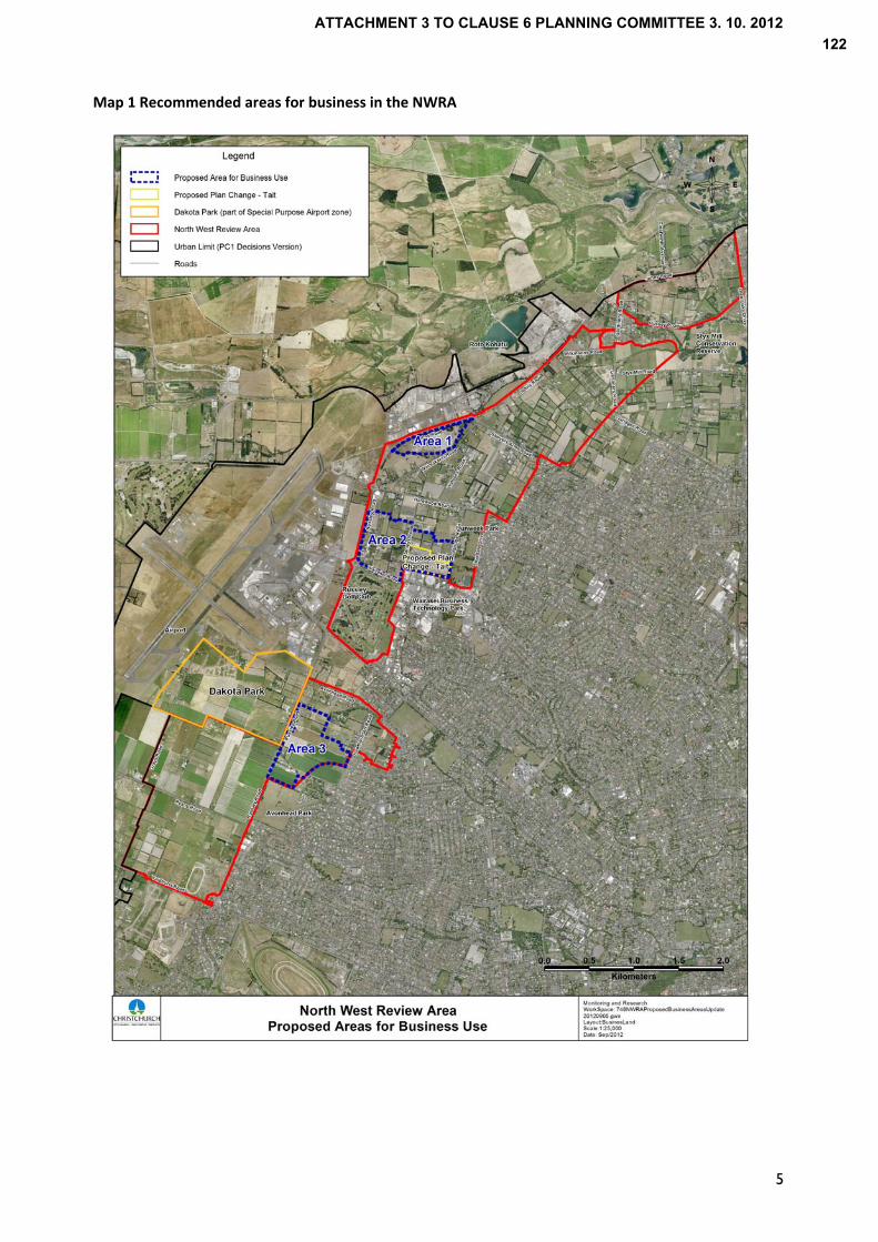
Map 1 Recommended areas for business in the NWRA
5
ATTACHMENT 3 TO CLAUSE 6 PLANNING COMMITTEE 3. 10. 2012122

6
1.0 Introduction 1.1 Location
The North West Review Area (NWRA) is located on the north‐west edge of Christchurch City. Extending for approximately 10 km along State Highway 1 (SH1) between Yaldhurst Road in the south and Johns Road adjacent to the Groynes/ Clearwater Resort in the north (See Map 2), the area is a long and relatively narrow strip of land of approximately 860 hectares. The land is primarily zoned Rural 5 in the Christchurch City Plan, with a smaller area in the north zoned Rural 3. The purpose of these zones is for the continuation of primary production while managing land use activities to avoid compromising airport operations and development.
Its location parallel to SH1 and adjacent to Christchurch International Airport contributes to the area’s role as a strategic corridor and gateway to the City. The review of the area and assessment of future land uses therefore needs to consider, amongst other things, how the area is perceived by those travelling through or adjacent to the NWRA.
There has been a history of pressure for the development of urban activities and rural subdivision. The zoning of the NWRA for urban activities has historically been resisted in planning documents, reflecting the environmental constraints and values associated with the area.
1.2 Purpose The purpose of this report is to evaluate the NWRA to determine its long term role, and the suitability of a range of potential land uses. Given its proximity to the NWRA and the focus of investigations on business land, it is also appropriate to consider the effectiveness of the existing Special Purpose (Airport) zone (SPAZ) framework and the scope of activities provided for in Dakota Park, a cargo and freight zone (marked on Maps 1 and 2) within the SPAZ, having regard to recent decisions on development in this area.
The need for a review of the NWRA arose in part from decisions on Proposed Change 1 (PC1) to the Regional Policy Statement (RPS) that stated it was not an appropriate ‘resource management treatment to leave the area exclusively as rural land over the next 35 years’. The Regional Council’s decisions on PC1 identified the area as ‘Special Treatment Area 1’ (STA) that required analysis and planning to consider the suitability of the area for different land uses.
The area was subsequently referred to as the ‘North West Review Area’ in Chapter 12A of the Operative RPS, as determined by the Minister of Earthquake Recovery in October 2011, and was shown outside the urban limits. Chapter 12A as made operative by the Minister of Earthquake Recovery replaced PC1 until the High Court’s ruling in July 2012 that determined that the Minister had acted unlawfully. While PC1 and Chapter 12A are the subject of appeals to Environment Court and Court of Appeal, there is a need for review of the NWRA regardless of the Courts decisions. It is an important area in the context of Greater Christchurch due to its location and the natural and physical resources in the area that requires a strategic approach to planning its future use.
The review of the area’s future role and potential land uses that the NWRA should provide for was also considered appropriate for the following reasons –
Work on three area plans2 covering different parts of the NWRA highlighted the need for a
comprehensive approach to how these areas develop
Pressure for subdivision and development in the NWRA
Need for a managed approach given the role of the area as a gateway to the City and strategic corridor
2 Belfast Area Plan, adopted by Council 2010; Memorial/Russley/Hawthornden Area Plan (Deferred 2005); Upper
Styx Harewood Area Plan (Deferred 2005)
ATTACHMENT 3 TO CLAUSE 6 PLANNING COMMITTEE 3. 10. 2012123
7
Demand for industrial business land
This report draws on information and analysis from a number of background reports and makes several recommendations on both the appropriate function of the NWRA, and potential land uses within the study area including business activities. It takes particular account of the impacts of development on natural and physical resources including the groundwater resources, highly versatile/ productive soils and the influence of the 50 dBA airport noise contour, which limits noise sensitive activities.
ATTACHMENT 3 TO CLAUSE 6 PLANNING COMMITTEE 3. 10. 2012124
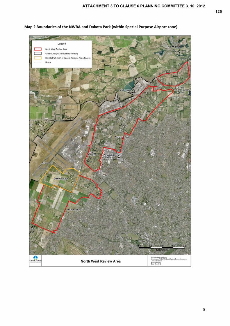
Map 2 Boundaries of the NWRA and Dakota Park (within Special Purpose Airport zone)
8
ATTACHMENT 3 TO CLAUSE 6 PLANNING COMMITTEE 3. 10. 2012125
9
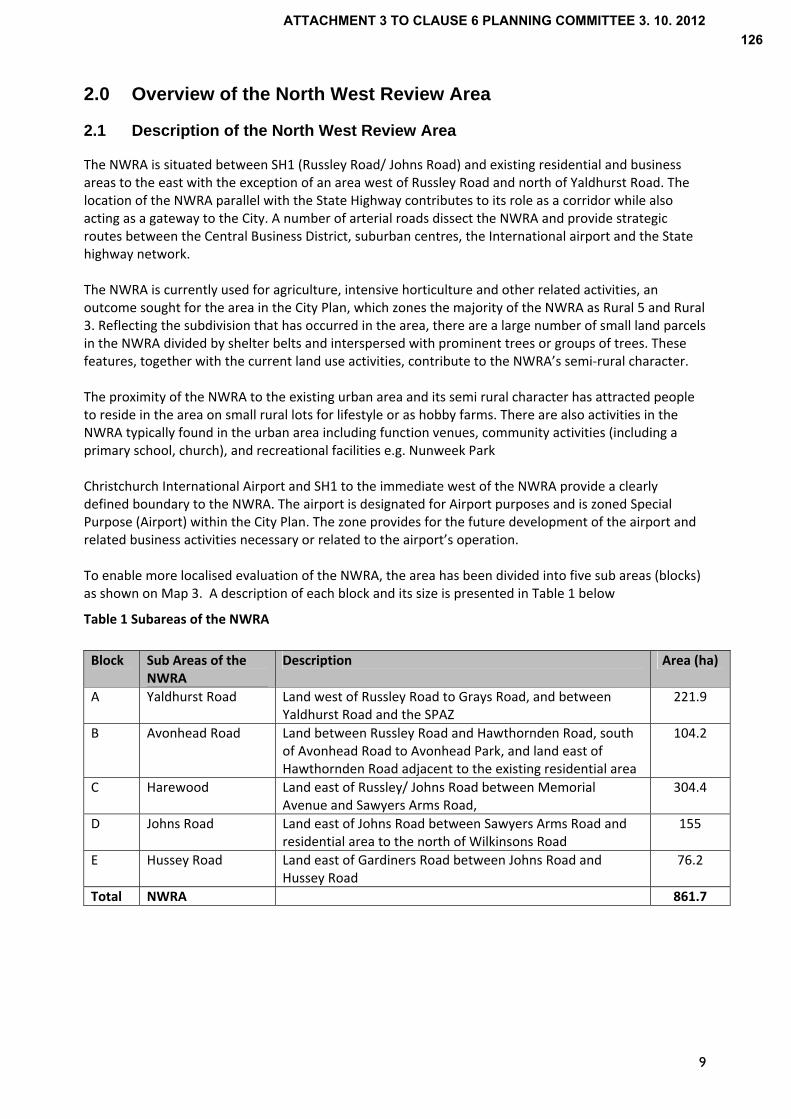
2.0 Overview of the North West Review Area 2.1 Description of the North West Review Area
The NWRA is situated between SH1 (Russley Road/ Johns Road) and existing residential and business areas to the east with the exception of an area west of Russley Road and north of Yaldhurst Road. The location of the NWRA parallel with the State Highway contributes to its role as a corridor while also acting as a gateway to the City. A number of arterial roads dissect the NWRA and provide strategic routes between the Central Business District, suburban centres, the International airport and the State highway network. The NWRA is currently used for agriculture, intensive horticulture and other related activities, an outcome sought for the area in the City Plan, which zones the majority of the NWRA as Rural 5 and Rural 3. Reflecting the subdivision that has occurred in the area, there are a large number of small land parcels in the NWRA divided by shelter belts and interspersed with prominent trees or groups of trees. These features, together with the current land use activities, contribute to the NWRA’s semi‐rural character. The proximity of the NWRA to the existing urban area and its semi rural character has attracted people to reside in the area on small rural lots for lifestyle or as hobby farms. There are also activities in the NWRA typically found in the urban area including function venues, community activities (including a primary school, church), and recreational facilities e.g. Nunweek Park Christchurch International Airport and SH1 to the immediate west of the NWRA provide a clearly defined boundary to the NWRA. The airport is designated for Airport purposes and is zoned Special Purpose (Airport) within the City Plan. The zone provides for the future development of the airport and related business activities necessary or related to the airport’s operation. To enable more localised evaluation of the NWRA, the area has been divided into five sub areas (blocks) as shown on Map 3. A description of each block and its size is presented in Table 1 below
Table 1 Subareas of the NWRA
Block Sub Areas of the NWRA
Description Area (ha)
A Yaldhurst Road Land west of Russley Road to Grays Road, and between Yaldhurst Road and the SPAZ
221.9
B Avonhead Road Land between Russley Road and Hawthornden Road, south of Avonhead Road to Avonhead Park, and land east of Hawthornden Road adjacent to the existing residential area
104.2
C Harewood Land east of Russley/ Johns Road between Memorial Avenue and Sawyers Arms Road,
304.4
D Johns Road Land east of Johns Road between Sawyers Arms Road and residential area to the north of Wilkinsons Road
155
E Hussey Road Land east of Gardiners Road between Johns Road and Hussey Road
76.2
Total NWRA 861.7
ATTACHMENT 3 TO CLAUSE 6 PLANNING COMMITTEE 3. 10. 2012126

Map 3 Subareas of the NWRA
E
D
C
B
A
The reasons for defining each block as is shown in Map 3 are as follows –
Block A is distinct from the rest of the NWRA as it is the only area on the west side of Russley Road. The block and land to the west is zoned Rural 5 with a dominance of agricultural/ horticultural activities. This contributes to its open character.
Block B is to the east of Russley Road and physically separated from the NWRA to the north by an area identified for business in PC1/ Chapter 12A as CB8 (Memorial Avenue). Area B exhibits a different character to Area A in that it is more enclosed by existing urban activities, which will be strengthened with the development of a residential greenfield area to the immediate south east (CW1 Russley). The area comprises a mix of rural lifestyle blocks and agricultural activities, which also distinguishes it from Area A.
Block C between Memorial Ave and Sawyers Arms Road is bounded to the west by Russley Road/ Johns Road and urban activities to the east including residential subdivisions, business development and recreational space.
Block D has a different character to Area C reflecting Area D’s interface with current rural activities to the east as opposed to urban activities. The area to the east of Area D is however identified as a residential greenfield area (CN3 Upper Styx) in PC1/ Chapter 12A (refer to Map 12), for which a plan change and preparation of an Outline Development Plan are at an early stage in the process. Given the change in land uses proposed for this area, there is a need to consider the effects of development in the NWRA on CN3 and the reverse, and it is therefore appropriate that Area D is treated separately
10
ATTACHMENT 3 TO CLAUSE 6 PLANNING COMMITTEE 3. 10. 2012127
11
Block E is physically separated from the rest of the NWRA and is surrounded to the immediate south west and east by residential activities, unlike Areas C and D which are bordered to the west by the airport.
The next section describes each block in more detail including the land use activities within and surrounding each block, and the zoning.
2.2 Description of the subareas within the NWRA Block A Yaldhurst Road
Block A borders Yaldhurst Road to the south, Russley Road to the east, Grays Road to the west and Christchurch international Airport to the north as shown on Map 4. The area continues to support agricultural and horticultural activities including vegetable crops reflecting the high quality soils. The open character of Block A reflects the land use activities and limited tree cover relative to other blocks in the NWRA. The openness of the area provides views west to the Southern Alps and south east to the Port Hills.
Block A has generally larger allotments than the rest of the NWRA, with lots up to 24 hectares and an average lot size of 4.7 ha. The larger size of allotments in this block supports the ongoing use of land for productive rural activities. Around the periphery of Block A there are a number of 4 hectare lots, which reflects the minimum lots size for the Rural 5 zone. To the south west of Block A, across Yaldhurst Road is a residential greenfield area known as Masham, identified in PC1/ Chapter 12A which is subject to subdivision and development with potential for up to 1,100 sections. There is a primary school on the south side of Yaldhurst Road (McKenzie Residential School) to the immediate west of the Masham subdivision. As shown on Map 5, Block A is zoned Rural 5. The area to the east of Block A across Russley Road is primarily zoned Living 1 with an small area zoned Business 4 south east of the intersection of Russley Road and Ryans Road. The Business 4 zone is a suburban industrial zone, the area fronting Russley Road comprising a mix of office and warehouse activities. To the north of Block A is land designated for Airport purposes, which is also zoned Special Purpose (Airport). The area of the Special Purpose zone adjoining Block A is under development as a business park known as Dakota Park (80 ha) (Refer to Map 2 showing the location of Dakota Park and Map 15 for a subdivision plan of Dakota Park). While it is intended as a Cargo and Freight zone for airport related activities, resource consents have been granted for a number of non‐airport related developments. This is described further in Section 6. The area to the west of Block is zoned Rural 5. Further west of Block A, an area extending south west to the intersection of Ryans Road and Pound Road is zoned Special Purpose (Airport), as a narrow extension into the Rural 5 zone. Block A acts as a gateway to rural areas west of the airport, the zoning of this area continuing west to the wider plains. This is distinct from the rest of the NWRA which is bordered to the west by SH1 and the airport.
Other points to note are
The majority of Block A lies within the 50dBA Ldn airport noise contour, defined through Variation 4 to PC1/ Chapter 22. An exception is the south east corner of Block A.
A waterway passes through the northern part of this block continuing beneath Russley Road into Block B of the NWRA.
Overhead 66kv transmission power lines cross the south eastern part of Block A, south of Ryans Road, continuing east through Avonhead Park on the opposite side of Russley Road to Block B, east of Hawthornden Road.
ATTACHMENT 3 TO CLAUSE 6 PLANNING COMMITTEE 3. 10. 2012128
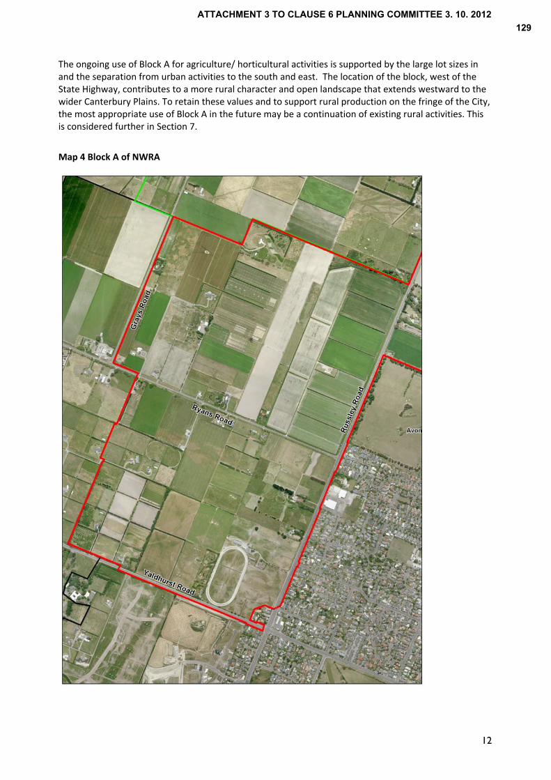
The ongoing use of Block A for agriculture/ horticultural activities is supported by the large lot sizes in and the separation from urban activities to the south and east. The location of the block, west of the State Highway, contributes to a more rural character and open landscape that extends westward to the wider Canterbury Plains. To retain these values and to support rural production on the fringe of the City, the most appropriate use of Block A in the future may be a continuation of existing rural activities. This is considered further in Section 7.
Map 4 Block A of NWRA
12
ATTACHMENT 3 TO CLAUSE 6 PLANNING COMMITTEE 3. 10. 2012129

Map 5 Zoning map of Blocks A and B
Avonhead Road
Russley Road
Ryans Road
Yaldhurst Road
Block B Avonhead Road
Block B is located on the east side of Russley Road and is divided by Hawthornden Road. Block B is bound to the north by Avonhead Road and to the south and south east by Avonhead Park, Avonhead Cemetery and 50dBA Ldn airport noise contour as shown on Map 6.
The land use activities in Block B comprise a mix of agriculture, residential and rural lifestyle living, reflecting the variation in lot sizes. The average lot size across all of Block B is 1.4 ha with section sizes ranging from 1,000 m2 on Avonhead Road to 8 ha in the lower part of the block bound by Hawthornden Road and Russley Road.
The northern part of the block between Hawthornden Road and Russley Road, comprises residential properties and lifestyle blocks with well established trees. Several properties have large homes that are positioned in the centre or towards the rear boundary. Also notable is Hawthornden House at 2 Hawthornden Road that is listed as a heritage item in the City Plan. The southern part of this block comprises larger parcels used for agricultural activities.
To the immediate south east of Block B, fronting Hawthornden Road is a small greenfield residential (CW1 Russley), identified in PC1/ Chapter 12A, which is yet to be rezoned. To the north of Avonhead Road is a Greenfield business area (CB8 Memorial Ave) known as the MAIL site, which separates Block B from Block C of the NWRA. The area is subject to a plan change for rezoning for business activities.
The land within this block is zoned Rural 5 as shown on Map 5. East of Hawthornden Road, the area within the NWRA is surrounded on three sides by residential properties zoned Living 1. At any point within this area all land is less than 200 metres from the boundaries of residential properties fronting Avonhead Road, Hawthornden Road, Withells Road or Westgrove Avenue. There are also a number of residential properties (1,000 m2 sections) fronting the east and west sides of Hawthornden Road.
13
ATTACHMENT 3 TO CLAUSE 6 PLANNING COMMITTEE 3. 10. 2012130

14
The area within the NWRA to the west of Hawthornden Road is zoned Rural 5, which adjoins a Living 1 zone to the immediate south east and north east as shown on Map 5. Avonhead Park to the south of Block B is zoned Open Space 2 and Avonhead Cemetery adjoining the Park and NWRA is zoned Conservation 4. To the west of Block B on the west side of Russley Road is zoned Special Purpose (Airport) in the City Plan. As described in the previous section, the area is subject to development as a business area known as Dakota Park. Access to Dakota Park is proposed directly from Russley Road (SH1) for north and south bound traffic. The New Zealand Transport Agency (NZTA) propose a grade separated intersection that will connect Capital A and B roads (roads within Dakota Park) with Russley Road via an underpass beneath Russley Road. This requires land on the east side of Russley Road within Block B, which is subject to further investigations and planning processes under the Resource Management Act. The entire block lies within the 50dBA Ldn airport noise contour, defined through Variation 4 to PC1 and in Chapter 22. The north eastern part of Block B straddling east and west of Hawthornden Road is located within the 55 dBA Ldn airport noise contour, and the northern part of the land between Russley and Hawthornden is also within the horizontal protection surface identified in the City Plan.
A waterway passes through the south western corner of this block although it stops short of Avonhead Cemetery. 66kv transmission lines also cross through Avonhead Park from Block A and continue through the eastern part of Block B.
In summary, the characteristics of Block B vary east and west of Hawthornden Road. The land to the east of Hawthornden Road is surrounded by residential properties in close proximity, which makes it less suitable for some land uses due to potential reverse sensitivity effects. The land west of Hawthornden Road close to Avonhead Road is characterised by residential properties, and a heritage building at 2 Hawthornden Road. This limits the potential for further development in the northern part of the block without potential effects on residential amenity and character. The southern part of the block between Hawthornden Road and Russley Road is different again with a more open character and fewer buildings that provides greater opportunities for development. Given its location between SH1 and Hawthornden Road, the ongoing rural use of this block is questionable and there is a need for consideration of other land uses.
ATTACHMENT 3 TO CLAUSE 6 PLANNING COMMITTEE 3. 10. 2012131
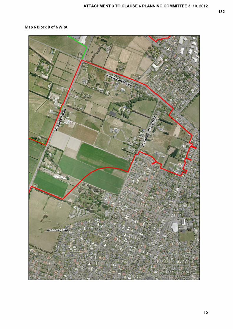
Map 6 Block B of NWRA
15
ATTACHMENT 3 TO CLAUSE 6 PLANNING COMMITTEE 3. 10. 2012132
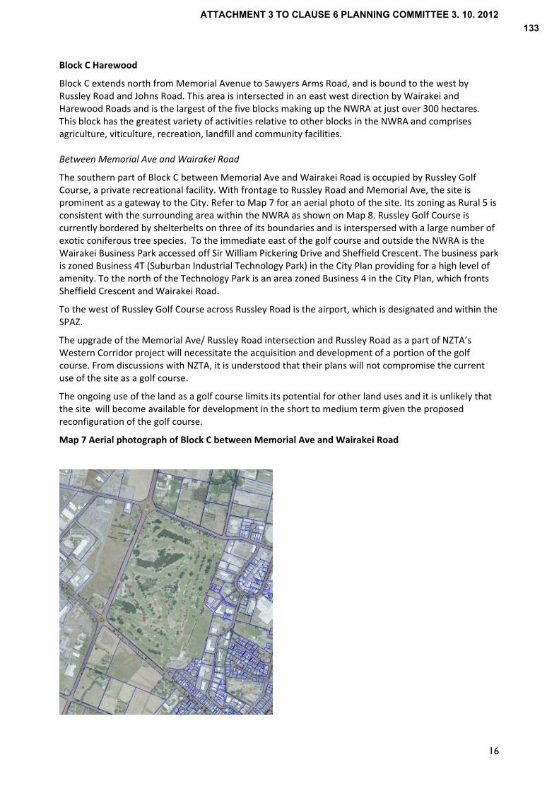
Block C Harewood
Block C extends north from Memorial Avenue to Sawyers Arms Road, and is bound to the west by Russley Road and Johns Road. This area is intersected in an east west direction by Wairakei and Harewood Roads and is the largest of the five blocks making up the NWRA at just over 300 hectares. This block has the greatest variety of activities relative to other blocks in the NWRA and comprises agriculture, viticulture, recreation, landfill and community facilities. Between Memorial Ave and Wairakei Road
The southern part of Block C between Memorial Ave and Wairakei Road is occupied by Russley Golf Course, a private recreational facility. With frontage to Russley Road and Memorial Ave, the site is prominent as a gateway to the City. Refer to Map 7 for an aerial photo of the site. Its zoning as Rural 5 is consistent with the surrounding area within the NWRA as shown on Map 8. Russley Golf Course is currently bordered by shelterbelts on three of its boundaries and is interspersed with a large number of exotic coniferous tree species. To the immediate east of the golf course and outside the NWRA is the Wairakei Business Park accessed off Sir William Pickering Drive and Sheffield Crescent. The business park is zoned Business 4T (Suburban Industrial Technology Park) in the City Plan providing for a high level of amenity. To the north of the Technology Park is an area zoned Business 4 in the City Plan, which fronts Sheffield Crescent and Wairakei Road.
To the west of Russley Golf Course across Russley Road is the airport, which is designated and within the SPAZ.
The upgrade of the Memorial Ave/ Russley Road intersection and Russley Road as a part of NZTA’s Western Corridor project will necessitate the acquisition and development of a portion of the golf course. From discussions with NZTA, it is understood that their plans will not compromise the current use of the site as a golf course.
The ongoing use of the land as a golf course limits its potential for other land uses and it is unlikely that the site will become available for development in the short to medium term given the proposed reconfiguration of the golf course.
Map 7 Aerial photograph of Block C between Memorial Ave and Wairakei Road
16
ATTACHMENT 3 TO CLAUSE 6 PLANNING COMMITTEE 3. 10. 2012133

Map 8 Zoning map of Block C between Memorial Ave and Wairakei Road
Wairakei Road
Russley Road
Memorial Ave
Wairakei Road to Harewood Road
The area between Wairakei Road and Harewood Road is divided by Stanleys Road and Wooldridge Road (See Map 9). Between Wairakei Road and Harewood Road, the predominant land uses include market gardening, nurseries and rural lifestyle activities. There is also a function centre/ venue fronting Wairakei Road, adjacent to the intersection of Russley Road and a group of residential properties to the immediate west of the intersection of Harewood Road and Wooldridge Road.
The area is zoned Rural 5 with the exception of Nunweek Park, which is zoned Open Space 2 and Harewood Primary School on Harewood Road, which is Zoned Cultural 3 (See Map 10).
Nunweek park provides for community, sport and recreation activities, the southern part of Nunweek Park being occupied by two hockey turfs, which meet the strategic needs of Canterbury Hockey. To the immediate east of Nunweek Park is a residential area zoned Living 1A in the City Plan.
To the south of this part of the NWRA is a Business 4 zone, which fronts Wairakei Road. Tait Electronics’s a prominent company in the manufacturing sector occupies sites within this zone and have lodged a draft plan change for rezoning approximately 10 ha within the NWRA between Wooldridge and Stanleys Roads to Business 4T. This indicates demand for business land in the area.
The origin of the Styx River is between Wooldridge and Stanleys Road, the former riverbed running east through Nunweek Park. This is a prominent natural feature in this area that should be recognised in any development.
17
ATTACHMENT 3 TO CLAUSE 6 PLANNING COMMITTEE 3. 10. 2012134

Having regard to the current use of Nunweek Park, it is not considered suitable for other activities and should continue to provide a green space for sport and recreation. Land between Wooldridge Road and Stanleys Road is immediately adjacent to the Business 4 zone on Wairakei Road and the area could therefore provide a logical extension of the business area, reflected in Tait’s proposal for rezoning approximately 10 ha. The extent of any development for urban activities in this area would be dependent on land becoming available while managing effects on residential properties to the north at the junction of Harewood Road/ Wooldridge Road. There is also the need to avoid effects on the natural and physical resources in this area including the origins of the Styx River, which is reflected by a swale between Wooldridge Road and Stanleys Road.
Map 9 Block C (between Wairakei Road and Harewood Road) of NWRA
18
ATTACHMENT 3 TO CLAUSE 6 PLANNING COMMITTEE 3. 10. 2012135

Map 10 Zoning map of Block C between Wairakei Road and Sawyers Arms Road
Sawyers Arms Road
Harewood Road
Wairakei Road
Harewood Road to Sawyers Arms Road
The area of Block C between Harewood Road and Sawyers Arms Road is divided by Waimakariri Road and Watsons Road as shown on Map 11. Like the area to the immediate south, the predominant land uses include market gardening, nurseries and rural lifestyle activities. There is also a viticultural activity known as ‘Omarino Wine Park’ fronting Harewood Road and a group of residential properties at the intersection of Waimakariri Road and Watsons Road.
Waimairi Pit, a former gravel extraction pit which has largely been filled occupies a site between Waimakariri Road and Johns Road. The site is gazetted as reserve for gravel extraction. The land is to be returned to the Crown, following which the reserve status will be reviewed.
The block is zoned Rural 5 as shown on Map 10 with land to the immediate east zoned Living 1A. To the north across Johns Road is a Business 6 zone, which is intended for “dry” industries and to the west is the airport, zoned SPAZ in the City Plan.
19
ATTACHMENT 3 TO CLAUSE 6 PLANNING COMMITTEE 3. 10. 2012136
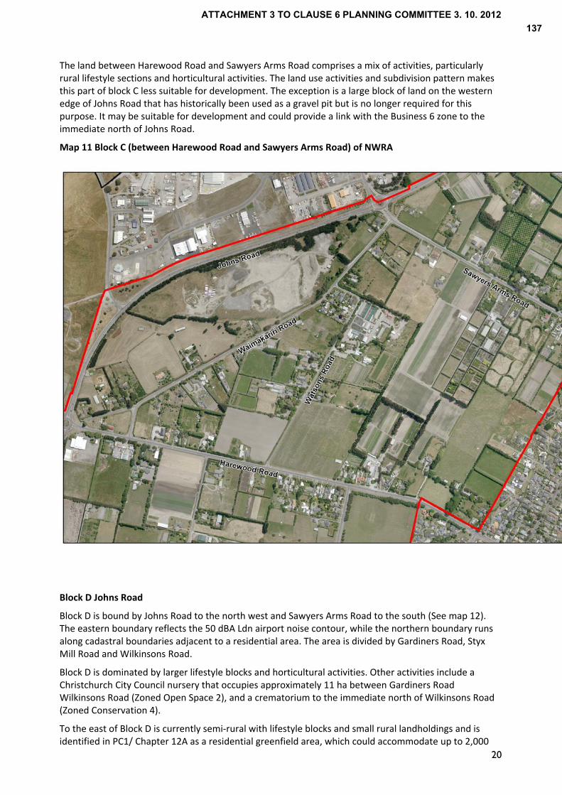
The land between Harewood Road and Sawyers Arms Road comprises a mix of activities, particularly rural lifestyle sections and horticultural activities. The land use activities and subdivision pattern makes this part of block C less suitable for development. The exception is a large block of land on the western edge of Johns Road that has historically been used as a gravel pit but is no longer required for this purpose. It may be suitable for development and could provide a link with the Business 6 zone to the immediate north of Johns Road.
Map 11 Block C (between Harewood Road and Sawyers Arms Road) of NWRA
Block D Johns Road
Block D is bound by Johns Road to the north west and Sawyers Arms Road to the south (See map 12). The eastern boundary reflects the 50 dBA Ldn airport noise contour, while the northern boundary runs along cadastral boundaries adjacent to a residential area. The area is divided by Gardiners Road, Styx Mill Road and Wilkinsons Road.
Block D is dominated by larger lifestyle blocks and horticultural activities. Other activities include a Christchurch City Council nursery that occupies approximately 11 ha between Gardiners Road Wilkinsons Road (Zoned Open Space 2), and a crematorium to the immediate north of Wilkinsons Road (Zoned Conservation 4).
To the east of Block D is currently semi‐rural with lifestyle blocks and small rural landholdings and is identified in PC1/ Chapter 12A as a residential greenfield area, which could accommodate up to 2,000
20
ATTACHMENT 3 TO CLAUSE 6 PLANNING COMMITTEE 3. 10. 2012137

households. The Council is currently preparing an Outline Development Plan for this area and a number of landowners are proposing to lodge a request for rezoning their land.
To the north of the area, across Wilkinsons Road is a small residential area which fronts Wilkinsons, Gardiners and Hussey Roads that is zoned Living 1E (See Map 13).
The Styx River runs in a north east direction through Block D before continuing east through Styx Conservation Reserve (outside the NWRA). The Styx River also forms a boundary between the Rural 3 and 5 zones to the east and west of the waterway respectively. The purpose of both zones is to provide for rural production. Smacks Creek, a tributary of the Styx River originates in Block D south of Wilkinsons Road and runs north east across Wilkinsons Road and Gardiners Road.
The use of the northern part of Block D for residential activities, a crematorium and Council nursery restricts the potential for development of some land uses that may have reverse sensitivity effects. Like the area south of Sawyers Arms Road, the land in this block is used for a mix of activities, particularly rural lifestyle sections and agricultural/ horticultural activities. The existing land use activities and subdivision pattern constrains its potential for urban development.
Map 12 Block D of NWRA
21
ATTACHMENT 3 TO CLAUSE 6 PLANNING COMMITTEE 3. 10. 2012138

Map 13 Zoning map of Blocks D and E
Johns Road
Hussey Road
Styx Mill Road
Gardiners Road
Block E Hussey Road
Block E is bound by Hussey Road in the south, Gardiners Road and Smacks Creek in the west, Johns Road in the north and the residential area of Northwood in the east (See Map 14). The area is characterised by rural lifestyle blocks with small scale paddocks contained in managed shelter belts. Unlike the rest of the NWRA, this block has a more undulating topography. Property sizes range from 3‐15 hectares, with the majority over 4 hectares. The larger lots are used for activities such as horse grazing, but there is also a motel and a holiday park. A gun club and former saw mill are known to have existed within the western portion of the block.
All of Block E is zoned Rural 3 in the Christchurch City Plan (see Map 13). The Block borders residential areas zoned Living 1 (Northwood) and Living 1 (Deferred) on the eastern boundary and Living 1E in the vicinity of Hussey and Gardiners on the south west boundary. To the north across Johns Road is the entrance to Clearwater Resort and to the east of this is the Groynes, zoned Open Space 2.
South of Hussey Road and outside of Block E is the Styx Mill Reserve (zoned Conservation 1) and the Willowbank Wildlife Park, zoned Rural 3. These two areas of open space comprise approximately 60ha between the Living 1 Zone at Northwood and the Living 1E zone around Gardiners Road.
Block E was identified in the notified version of PC1 as a residential greenfield area CN2. This was subsequently removed as a future growth area in variation 4 to PC1, which proposed a revised airport noise contour. In the subsequent decisions on PC1 it was shown within Special Treatment Area 1, while in Chapter 12A it formed part of the Policy 15F area identified for review.
Access to the area is through a residential subdivision at either end of Hussey Road. Reduced access from Gardiners Road and Wilkinsons Road to the State Highway further reduces the accessibility between this block and the surrounding area and which constrains its potential for urban activities. This is considered further in Section 7.
22
ATTACHMENT 3 TO CLAUSE 6 PLANNING COMMITTEE 3. 10. 2012139
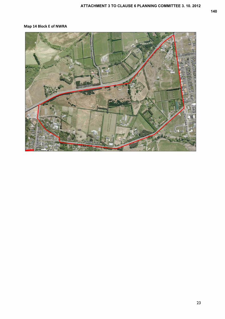
Map 14 Block E of NWRA
23
ATTACHMENT 3 TO CLAUSE 6 PLANNING COMMITTEE 3. 10. 2012140

24
3.0 Policy Context
3.1 Introduction
The review of the NWRA is required by Policy 12 (Special Treatment Areas) of PC1, which states “specific analysis and planning shall be undertaken to achieve the sustainable management of the natural and physical resources of … (a) Northwest Christchurch (STA1) to determine the medium and long‐term sustainable future of the area affected by airport noise.” This reflects the decision on PC1 that “to leave this land unable to be developed for any urban purposes over the next 35 years is illogical, and not an appropriately long‐term resource management planning approach to the use of the land.”
The statutory framework at a national, regional and local level provides direction for planning the future role of the NWRA and land uses appropriate in the area. Before consideration of the current policy framework, an overview is provided of the historical planning context that has informed the zoning and land use activities in the area.
The consideration of specific land uses and the appropriateness of those land use activities in the context of current policy is considered in Section 6.
3.2 Historical Policy Context to NWRA
Regional Context
The NWRA has historically been identified as a rural area in Regional Planning Schemes prepared by the Christchurch Regional Planning Authority, and subsequently the Canterbury United Council. Provisions sought to restrict urban development to avoid the loss of rural resources, the key issue being the potential for urban sprawl. The 2nd review of the Regional Planning Scheme prepared under the Town and Country Planning Act 1977 referred to a ‘green belt’ that had provisions limiting the potential for subdivision, residential and non‐rural activities.
While the reference to a ‘green belt’ has disappeared, the Regional Policy Statement (1998) prepared under the Resource Management Act continues to have objectives focussed around urban consolidation, the protection of versatile soils and groundwater resources.
PC1 to the Operative Regional Policy Statement as notified in 2007 identified the majority of the area known as the NWRA outside the urban limits, the exception being Block E which was identified as a residential greenfield area. Decisions on PC1 subsequently identified the subject land as a Special Treatment Area within the City’s urban limits/boundary with an assessment required to determine its long term use.
‐ Local context
The majority of the North West Review Area was within the jurisdiction of Waimairi County Council, the exception being land west of Russley Road (Block A) that was in Paparua County up until amalgamation in 1989. The first Waimairi District Scheme (operative 1965) and Paparua District Scheme (operative 1974), prepared under the Town and Country Planning Act 1953 zoned the NWRA as Rural, which provided for farming and associated rural activities. This was carried forward in the first review of the Waimairi District Scheme (Operative 1974). The first review of the Paparua District Scheme (Operative 1985) zoned the area west of Russley Road (within the NWRA) as Rural 3, which continued to provide for farming and other rural activities.
The first Waimairi District Scheme introduced the concept of an ‘Economic unit’ which enabled subdivision less than 5 acres (or 2 ha) if it could be demonstrated that an allotment could be used as an “independent economic farming unit”. This has contributed to the current subdivision pattern in the majority of the NWRA with a large number of small allotments.
The 2nd review of the Waimairi District Scheme (made Operative in 1989), prepared under the Town and Country Planning Act 1977, identified the area as largely within a Rural Horticultural (H) zone the purpose of which was to promote land use activities that utilise the Class I and II soils for sustained and
ATTACHMENT 3 TO CLAUSE 6 PLANNING COMMITTEE 3. 10. 2012141

25
intensive food production. It also identified the majority of the Rural H zone within a Noise Exposure Line. The controls associated with the noise exposure line were intended to protect residents living in the vicinity of the airport from airport related noise and to protect the airport from reverse sensitivity effects.
The historical zoning of the NWRA for rural activities has been carried through into the Christchurch City Plan (2005), which zones the majority of the NWRA as Rural 5 (Airport Influences Zone) and Rural 3 (Styx‐Marshland zone).
The purpose of the Rural 5 zone is primarily intended for the continuation of primary production while managing land use activities to avoid compromising Airport operations and development. Collectively, the policies in the Plan support the retention of rural activities and a level of amenity that does not impinge on the Airport’s operation and reinforces the consolidation of growth within existing living and business areas. Provisions in the City Plan abandoned the ‘economic unit’ criteria in favour of a 4 ha minimum lot size for subdivision.
3.3 Current Policy Context to NWRA
The current policy context comprises legislation, strategies and plans that inform the future role of the NWRA and appropriate land uses in the area. A background document has been prepared on the policy framework. Those documents of particular significance include ‐
National
Resource Management Act
National policy and standards
Local Government Act
Regional
Operative and Proposed Regional Policy Statement
PC1, Chapters 12A and 22 of the RPS
Canterbury Natural Resources Regional Plan (Operative)
Recovery Strategy for Greater Christchurch
Local
Christchurch City Plan
Belfast Area Plan
Each of these documents is considered in more detail below
National
‐ Resource Management Act (RMA)
In review of the NWRA there is a need to ensure consistency with the RMA’s purpose of promoting the sustainable of natural and physical resources and enabling people and communities to provide for their social, economic and cultural wellbeing and for their health and safety. In promoting the sustainable management of the NWRA, the function of the area and land uses identified should support people’s social and economic wellbeing while sustaining the potential of natural and physical resources. This includes the groundwater resource and versatile/ productive soils to meet the reasonably foreseeable needs of future generations. The land uses identified as appropriate through the review should also support the health and safety of the population by avoiding the development of activities in the NWRA that are sensitive to noise. The 50
ATTACHMENT 3 TO CLAUSE 6 PLANNING COMMITTEE 3. 10. 2012142
26
dBA Ldn airport noise contour defines the boundary within which noise sensitive activities including residential should be avoided. The other elements to consider in ensuring the sustainable management of the NWRA include the need to
preserve the natural character of rivers and their margins, which should be reflected in the planning of development adjacent to waterways such as the Styx River.
protect historic heritage, including buildings that reflect the history of the area as is evident in Blocks B and C
Recognise the relationship of Māori and their culture and traditions with their ancestral lands, water, sites, wāhi tapu (sacred places) and taonga (cultural treasures)
‐ Local Government Act
The Local Government Act provides for local authorities to play a role in promoting the social, economic, environmental, and cultural well‐being of their communities, taking a sustainable development approach. In providing for the social and economic wellbeing of the community, Council will provide essential services to enable further development.
The existing and future provision of infrastructure needs to be considered in review of the NWRA, having regard to the efficiencies of servicing areas, the timing of infrastructure upgrades and the funding implications.
Council also has a responsibility to apply consultation principles under the Local Government Act and in doing so, it needs to ensure it understands the views of the community, consider these views and decides how the matters raised can be addressed. Consultation with the public on the NWRA has provided a range of views, which are being considered in determining the appropriate land use activities in the NWRA.
‐ National Policy and Standards
National Policy Statements (NPS) and National Environmental Standards (NES) provide direction at a national level on a range of environmental matters. The following are of relevance to the NWRA ‐
Freshwater management (NPS) The recommendations on the NWRA should be consistent with the NPS’s objectives of maintaining or improving the overall quality of water and safeguarding the life‐supporting capacity of freshwater. In achieving this, adverse effects on surface waterways and groundwater resources beneath the NWRA should be avoided or otherwise mitigated. Effects of development within the NWRA can have downstream effects if not appropriately managed through the use of buffers and treatment of stormwater as part of a catchment wide approach.
Electricity transmission (NPS and NES) The NPS on Electricity Transmission requires the Council to manage adverse effects caused by development near high‐voltage transmission lines. Transmission lines run across Blocks A and B and therefore development in these blocks would need to be set back an appropriate distance to avoid effects on the operation, maintenance and upgrade of the lines.
Assessing and Managing Contaminants in Soil (NES)
The NES requires the identification and assessment of contaminated land to ensure remediation and management is undertaken before development. There are a number of known or potentially contaminated sites in the NWRA. Any area identified for development will require further investigation and if appropriate remediation to enable its development.
ATTACHMENT 3 TO CLAUSE 6 PLANNING COMMITTEE 3. 10. 2012143
27
Sources of Human Drinking Water (NES) The NES requires consideration of the effects of land use activities on drinking water supplies and the risk of contamination, which is particularly important in the NWRA. Beneath the NWRA are groundwater resources that provide drinking water to Christchurch residents. There is a need to avoid activities that may compromise groundwater quality including the storage and use of hazardous substances.
Regional
‐ Operative and Proposed Regional Policy Statements (RPS)
The Canterbury Regional Policy Statement (RPS) was made operative in June 1998. The RPS provides an overview of the resource management issues of the Canterbury region and sets out the objectives, policies and methods to address those issues. The Proposed Regional Policy Statement has been subject to hearings with decisions released on the 21st July 2012. With appeals limited to points of law, significant weight can be given to the Proposed RPS. The following objectives from the decisions version of the Proposed RPS are particularly relevant to the NWRA
Development is to be located and designed to achieve a consolidated, well designed and sustainable growth in and around existing urban areas (Objective 5.3.1). In the context of the NWRA, development should be adjacent to the existing or proposed urban activities, encouraging consolidation
Development is to be compatible with and result in the continued safe, efficient and effective use of regionally significant infrastructure while also avoiding, or otherwise remedying or mitigating effects (Objective 5.3.1). It is therefore necessary for development in the NWRA to not compromise the function and operation of SH1 and Christchurch International Airport.
Development should also avoid adverse effects on natural and physical resources, or where avoidance is impracticable, remedy or mitigate effects. The explanation describes such effects as a change from rural to urban activities leading to the loss of a resource. In the context of the NWRA, the loss of highly versatile/ productive soils as a result of development is an issue and there is a need to consider alternative locations that urban activities could occur in the NWRA to avoid adverse effects.
The region’s freshwater resources are to be sustainably managed to enable people and communities to provide for their economic and social well‐being while ensuring the life‐supporting capacity of freshwater is safeguarded (Objective 7.2.1). In the context of the NWRA, there is a need to ensure adverse effects on the groundwater aquifers are avoided through controlling the activities that are provided for in the area.
The natural character values of rivers and their margins are to be preserved and these areas protected from inappropriate subdivision, use and development and restored or enhanced where appropriate (Objective 7.2.1). As discussed earlier, a number of waterways including the Styx River run through the NWRA and there is a need to protect and where possible, restore the riparian areas
‐ Proposed Change 1 and Chapter 12A of the RPS
On 28 July 2007, PC1 to the RPS was publicly notified. PC1 gives effect to the Greater Christchurch Urban Development Strategy and provides a strategic approach to managing growth across Greater Christchurch. PC1 defines urban limits for Christchurch City and surrounding townships and within the
ATTACHMENT 3 TO CLAUSE 6 PLANNING COMMITTEE 3. 10. 2012144

28
urban limits identifies areas for future residential and business growth. In respect of the area referred to as the NWRA, the notified version of PC1 identified
all of Block A outside the urban limits;
most of Block B outside the urban limits, except for a small area in the south of the block which was included in the residential greenfield area CW1 Russley. CW1 had a total household allocation of 360;
Block C outside the urban limits;
a part of the eastern area of Block D within the residential greenfield area CN3 Upper Styx (CN3 had a total household allocation of 2470 under Policy 6);
all of Block E of the NWRA within the residential greenfield area CN2 West Belfast.
Subsequently, Variation 4 to PC1 was notified, which proposed a revised airport noise contour, removal of the residential greenfield area, CN2 (Block E) and a change to the Urban Limit, putting the majority of the NWRA outside the urban limits.
In December 2009, after hearings on submissions, the decisions on PC1 were notified. Those decisions identify the NWRA as a Special Treatment Area 1 (STA1) within the urban limits. The Council had lodged an appeal on this aspect of PC1 and sought that it be identified outside the urban limits with provision for 100 ha of business land. The 100 ha would be deemed to be within the urban limits upon the completion of this review.
Land between Memorial Ave and Avonhead Road (Known as the MAIL site) was excluded from the STA1 and identified as a greenfield area for business (CB8 comprising 19 hectares).
STA’s are subject to Policy 12: Special Treatment Areas in PC1, which requires the Christchurch City Council to undertake specific analysis and planning of the STA1 area to determine the medium and long‐term sustainable future of the area affected by airport noise and then to provide appropriate zoning or other provisions for the area.
PC1 was subject to appeals to the Environment Court up til October 2011 when PC1 was revoked and Chapter 12A and Chapter 22 were inserted into the Operative RPS by the Minister of Earthquake Recovery under Section 27 of the Canterbury Earthquake Recovery Act.
Chapter 12A closely resembled the decisions (December 2009) version of PC1. In respect of the NWRA, STA1 was renamed the ‘North West Review Area’ and was annotated on Map 1 of Chapter 12A as a Policy 15(f) area.
The geographic boundary of the NWRA reflected the boundary of STA1 but unlike the STA, the NWRA was outside the urban limits. Chapter 12A also included the NWRA in Table 3: Business Land Areas for Greater Christchurch 2007‐2041, with a total maximum area of 100 hectares for business, dependent on the outcome of a review (this Review). A note below Table 3 of Policy 6 in Chapter 12A stated that the area identified for business in the NWRA as a part of the review would be deemed to be within the urban limits.
An application for judicial review of the Minister’s decision to revoke PC1 and insert Chapters 12A and 22 into the RPS was lodged and subsequently granted on 24 July 2012. The effect of this ruling was for the Minister’s decision to be set aside and for outstanding appeals on PC1 to the Environment Court to be reinstated.
While the High Court’ s decision has subsequently been appealed to the Court of Appeal and there is therefore the possibility of Chapters 12A and 22 being reinstated, the current policy document for managing the future growth of Greater Christchurch and of relevance to the NWRA at the time of preparing this report is the decisions version of PC1 December 2009. This effectively means that the area known as the NWRA is a Special Treatment Area and lies inside the urban limits.
While PC1 and Chapter 12A are the subject of appeals to Environment Court and Court of Appeal respectively, there is considered to be a need to review the NWRA regardless of the Courts decisions. It
ATTACHMENT 3 TO CLAUSE 6 PLANNING COMMITTEE 3. 10. 2012145

29
is an important area in the context of Greater Christchurch due to its location and the natural and physical resources in the area that requires a strategic approach to planning its future use.
Chapter 22
As stated above, the Minister of Earthquake Recovery inserted Chapter 22 into the RPS in October 2011. Policy 2 of that chapter sought to avoid noise sensitive activities within the 50 dBA Ldn airport noise contour to avoid effects on the operation of Christchurch International Airport. Noise sensitive activities were defined as:
Residential activities other than those in conjunction with rural activities that comply with the rules in the relevant district plan as at 23 August 2008;
Education activities including pre‐school places or premises, but not including flight training, trade training or other industry related training facilities located within the Special Purpose (Airport) Zone in the Christchurch District Plan or on other land used or available for business activities;
Travellers accommodation except that which is designed, constructed and operated to a standard that mitigates the effects of noise on occupants;
Hospitals, healthcare facilities and any elderly persons housing or complex.
The same definition is in PC1. In the wider context of a review of land for development (Policy 16(e) of PC1), “Noise Sensitive Activities” within the 50 dBA Ldn noise contour should be managed so as to not compromise the operation of Christchurch International Airport.
Canterbury Natural Resources Regional Plan
The Canterbury Natural Resources Regional Plan (NRRP) became operative in June 2011. The Water Quality and Water Quantity chapters of the NRRP are of particular relevance to the NWRA as the area is underlain by unconfined and semi‐confined aquifers. The objectives and policies in the NRRP emphasise the importance of ensuring the continued supply of water to the aquifers as well as protection of Canterbury’s groundwater and surface water resources.
The principle objective guiding the management of groundwater is WQL4(1), which states ‘the quality of Christchurch groundwater is maintained or enhanced as far as practicable in its overall high quality state in the long term’. The explanation to this objective describes the potential for intensification of land use activities over the recharge area to give rise to adverse effects if not appropriately managed.
The NRRP identifies ‘Christchurch Groundwater Protection Zones’, the most vulnerable parts of the groundwater system which are a principal source of drinking water for Christchurch City. The explanation to policies on the Groundwater Protection Zone describe Zone 1, which the majority of the NWRA is within, as being particularly vulnerable to potential adverse effects arising from land use activities.
The explanation notes that uncontrolled land use intensification may increase the likelihood of adverse effects from contaminants entering groundwater. The types of land use activities that are noted as having potential to adversely effect groundwater include inappropriate waste disposal practices, accidental spillage and increased amounts of wastes such as sewage and stormwater. The explanation does not state that urban growth not involving hazardous substances etc. is to be avoided, rather that it should be properly managed.
Territorial authorities are directed to prevent, avoid or mitigate adverse effects on groundwater quality as appropriate to the circumstances, managing any potential adverse effects from land uses that may be established.
ATTACHMENT 3 TO CLAUSE 6 PLANNING COMMITTEE 3. 10. 2012146

30
The most challenging rule for urban development in the NWRA is Rule WQL36, which limits the amount of excavation that can occur if excavation is over 5 metres in depth or goes into groundwater in Protection Zones 1, 1A, 1C, 1D or 2. However urban development in the NWRA is only likely to contravene this rule if deep excavation involving volumes in excess of 100m3 were necessary. These depths and volumes are considered unlikely through much of the study area for a wide range of activities under consideration.
A further issue for consideration is the potential for increased urbanisation of the NWRA to reduce the amount of recharge percolating to the aquifers through an increase in impermeable site coverage. However, no assessment has been made on the contribution of the NWRA to recharge quantities. Best practice stormwater management would have a large influence on the amount of stormwater able to be returned to the aquifer as a result of any specific development in the NWRA.
As part of a plan change, there is scope for further consideration of an impermeable surfaces rule in the City Plan in conjunction with rules in the NRRP which already adequately address stormwater management specifically for this area.
Recovery Strategy for Greater Christchurch
The Recovery Strategy, prepared under the Canterbury Earthquake Recovery Act 2011, came into effect on 1 June 2012. The Recovery Strategy has statutory effect and sits alongside other statutory documents such as the City Plan. There is a need to ensure consistency with the Recovery Strategy. The review of the NWRA while not directly related to recovery, will support the achievement of goals in the strategy including –
Revitalise greater Christchurch as the heart of a prosperous region for business, work, education and increased investment (Economic Recovery) While the review of the NWRA commenced before the earthquakes, the identification of areas for industrial business development will assist with the recovery of Christchurch. There are indications of demand for land in the western part of the City as businesses look to relocate due to damage to land and/or buildings in the east. There is also potential demand for land associated with the rebuild of Christchurch, particularly from the construction and manufacturing sectors. The identification of land for business will assist in meeting this demand, providing capacity for growth and investment.
Develop resilient, cost effective, accessible and integrated infrastructure, building, housing and transport networks (Built Environment Recovery) The goals of this programme include zoning sufficient land for recovery needs and coordinating and prioritising infrastructure investment. The review of the NWRA will provide the opportunity for the identification of land for business development including companies displaced due to the earthquake and other activities, while protecting natural and physical resources for future generations.
Christchurch
Christchurch City Plan
The Christchurch City Plan’s (2005) overall objective is the sustainable management of natural and physical resources of the Christchurch environment. The relevant outcomes sought by the City Plan include
Adequate provision of a quality water supply
Protection and enhancement of the diversity and integrity of ecosystems, and important heritage buildings, places and objects
ATTACHMENT 3 TO CLAUSE 6 PLANNING COMMITTEE 3. 10. 2012147
31
Avoiding, remedying and mitigating adverse environment effects of resource use and activities upon valuable resources
Enabling opportunities for environmentally sound growth and development
Fostering and promoting amenity values which contribute to the City's pleasantness and aesthetic coherence
Encouraging diversified economic activity to reduce economic vulnerability
Encouraging more efficient use of resources, notably land and existing structures in the City. Objectives in the City Plan seek a form of development that maintains and enhances natural and physical features and characteristics. The relationship between the natural and physical features is described as creating the form of the City, which is to be achieved through encouraging diversity and maintaining the form, character and coherence of each area. In ensuring consistency with objectives and policies in the City Plan, there is a need to retain the rural amenity of the NWRA, protect groundwater recharge areas and versatile soils and manage urban growth to avoid adverse effects on these natural resources. Growth is to be managed through consolidation of urban areas, which in the context of the NWRA is a pattern of development that avoids isolated and dispersed patterns of urban growth. There is also a need to ensure the airport’s operation is not impeded by development in the NWRA.
While the area is subject to review, the current zoning of the NWRA is a starting point for planning the area. The majority of the NWRA is zoned Rural 5 (Airport Influences) or Rural 3, the latter extending over the eastern part of Block D and all of Block E. The purpose of the Rural 3 and Rural 5 Zones is to provide for the continuation of primary production, reflecting its historical use. The Rural 5 zone is also intended as a buffer where land use activities are to be managed to avoid compromising Airport operations and development.
The zone standards for the NWRA generally permit residential dwellings on sites no less than 4ha in area, which constrains the number of dwellings that can locate in the NWRA, thereby minimising potential for reverse sensitivity effects on the airport’s operation and protecting the amenity of residents.
The standards restrict site coverage and require large setbacks from allotment boundaries to encourage the sense of spaciousness and visual amenity levels that are consistent with promoting the maintenance and enhancement of rural amenity and character. These standards also support the objectives and policies of the City Plan in regards to protecting versatile soils and the groundwater recharge area.
Belfast Area Plan
The Belfast Area Plan, adopted by Council in 2010 provides direction for managing growth in the Belfast area while maintaining and enhancing natural and physical resources. The area plan covers the entirety of Block E and a part of Block D of the NWRA, and refers to the status of both Blocks as a Special Treatment Area consistent with PC1. The Area Plan identifies the need for a buffer along the Styx River, consistent with other plans and strategies. Styx River – relevant policies
‐ Styx Vision 2000 ‐ 2040
The Styx Vision 2000 – 2040, adopted by Christchurch City Council in July 2001, provides visions for the future management of the Styx catchment, which a large area of the NWRA is within. A vision is for a ‘Source to Sea experience’ of reserves, which can be supported through the identification of land as esplanade reserve to protect riparian areas, and subject to funding, enhance the ecological, landscape and Tangata Whenua values.
ATTACHMENT 3 TO CLAUSE 6 PLANNING COMMITTEE 3. 10. 2012148

32
‐ Styx River Stormwater Management Plan A Stormwater Management Plan has been prepared to enable an integrated approach to the management and treatment of stormwater from the Styx catchment. The plan forms part of an application for resource consent to be submitted to the Regional Council in September 2012 to enable the discharge of stormwater from the NWRA to be approved under Council’s application, pursuant to Rule WQL7 of the Natural Resources Regional Plan.
3.4 Summary This section has provided an overview of the policy framework to inform recommendations on the function of the NWRA and land uses appropriate in the NWRA. Key points emerging from the policy framework include ‐
o Development should support the objective of urban consolidation by being contiguous with existing or proposed residential and business areas
o Groundwater and surface water quality is to be maintained or enhanced by avoiding adverse effects of land use changes
o The natural character of rivers and their margins is to be maintained and enhanced through the identification and acquisition of land
o Versatile soils are to be protected where appropriate for future generations o Development should not compromise the safe, efficient and effective operation of the strategic
road network o Adequate provision is to be made for sewage disposal from new development while maintaining
public health and minimising adverse effects on the environment o There is a need for the adequate provision of a water supply to new developments that is
reliable and safe for human consumption o Land use activities do not have an adverse effect on the operation and development of
Christchurch International Airport Further analysis of the policy framework is provided in Section 6, which considers the appropriate of different land use activities.
ATTACHMENT 3 TO CLAUSE 6 PLANNING COMMITTEE 3. 10. 2012149
33
4.0 Consultation
4.1 Introduction
The Council is to undertake “specific planning investigations in relation to the three Special Treatment Areas (including the NWRA) in conjunction with landowners within the areas and other stakeholders” (Policy 12, PC1).
The Christchurch City Council undertook consultation with land owners, occupiers and interest groups in the NWRA at an initial stage in the review. Views were sought on the future development potential and types of land use activities sought in this fringe location.
The following section describes the process and key findings from the consultation.
4.2 Consultation Process
The community had the opportunity to provide their feedback and input by attending drop‐in sessions, sending in feedback and contacting project staff directly.
Consultation with the community comprised the following:
Presentations to Community Board(s) and meetings with other stakeholders including NZTA, Christchurch International Airport Limited (CIAL) and Tait Electronics from early 2011.
An information pamphlet was sent to landowners and key stakeholders for input/submissions on the 4th July 2011.
A ‘Drop In’ session was held at the Harewood Community Hall on the 13th July 2011.
Input/submissions on the NWRA closed on the 5th August 2011.
There were three aspects of the “review” that the public were asked for their feedback on including
What would people like to see retained or changed in the North‐West Review Area over the next 30 years?
What level of development should take place?
Where should development be located?
4.3 Summary of Key Findings
General findings
A total of 87 submissions were received within the submission period. Of the 87 submissions, 64 submissions came from individuals or couples. This was followed by Corporations and Organisations with 8 and 5 responses respectively. Of those who responded, 71 out of the 87 submitters (82%) were residents in the area.
Feedback from the consultation is summarised below
What to Retain?
The key findings from community and stakeholder feedback indicate a desire to retain the areas’ rural character and amenity, respondents valuing the sense of openness and spaciousness. There was also support for the retention of a buffer between rural/urban and residential/airport.
ATTACHMENT 3 TO CLAUSE 6 PLANNING COMMITTEE 3. 10. 2012150
34
Change
There was also support for change over the next 30 years with an increase in development. While there was recognition of the airport noise contour acting as a constraint to residential activities, submitters sought a change from the 50 dBA Ldn airport noise contour to the 55 dBA Ldn noise contour to enable residential development . There was also a desire for the minimum net area for a residential unit to be reduced. However, there was little consensus on what the minimum lot size should be. There was support for land to be identified for business. It was suggested that business development was most appropriate alongside or as an extension of existing business/commercial areas on Wairakei Road or to compliment the existing developments on the Airport land near Russley and Johns Road. There was also support for the intersection of Memorial Ave/ Russley Road to be a prominent gateway, reflecting the ‘Garden City’ theme. Improvements were also sought to the Johns Road /Russley Road corridor with planting on the roadside to enhance the visual amenity and to provide a visual buffer between the City and the airport. Other points raised included the need for traffic effects to be managed and support for pedestrian and cycle facilities.
4.4 Summary
The results from Council’s consultation process indicate that the community want to protect and retain the rural character of the area and for it to act as a buffer between residential areas and the airport. There was also support for change and development within the area. While the airport noise contour was recognised as a constraint to development, there was support for a reduction in section sizes to enable residential development. Business development was also supported as an extension of existing areas.
ATTACHMENT 3 TO CLAUSE 6 PLANNING COMMITTEE 3. 10. 2012151
35
5.0 Function of the North West Review Area The majority of the NWRA currently serves a purpose of providing for ongoing primary production while ensuring land use activities are managed to avoid compromising airport operations and development. The long term role of the NWRA for rural activities was questioned in hearings on PC1, the commissioners recommendations (and Regional Council’s decisions) stating that it was not an "appropriate resource management treatment to leave this land exclusively as rural land over the next 35 years". Having regard to this decision, which has necessitated a review, it is not appropriate for the current zoning to be retained. The NWRA continues to be an area where activities need to be managed to avoid compromising airport operations and development, reflecting PC1 and Chapter 12A that identify the area within the airport noise contour. In this context, the NWRA will continue to serve as a buffer to support the long term operation and development of the airport while protecting people from adverse effects. Its location on the fringe of the City and surrounded to the west by the airport warrants a different approach relative to other areas on the edge of Christchurch. Its location parallel with SH1 the NWRA a role as a part of a strategic corridor while also being a gateway to and from Christchurch, whether it be for travellers bypassing Christchurch or those arriving or departing Christchurch from the International Airport. As an area on the fringe of Christchurch, the NWRA also benefits from close proximity to established residential and business areas and could serve a function of providing for land use activities that serve these areas i.e. open space, community facilities. The natural resources in the NWRA are also a factor in determining its function. While the decisions on PC1 stated that it is not appropriate to leave the land exclusively in rural use, it remains an area of highly versatile and productive soils beneath of which is the groundwater resource serving the water supply needs of Christchurch and land uses above. The historical use of the area for agricultural and horticultural activities has given the NWRA a different character relative to other parts of the City with open areas interspersed with shelterbelts and trees that provide prominent features on the landscape. These values need to be recognised in the development of the NWRA. Having regard to the values of the area, its location and the conclusions on PC1, the function of the NWRA is considered to be as a ‘Rural Urban Fringe’. An rural‐urban fringe location is regarded as the transition between urban and rural areas that provides for activities typically associated with an peri‐urban area while retaining its openness and vegetation. A rural‐urban fringe area is characterised by certain land uses, which have either purposely moved away from the urban area, or require much larger tracts of land for example:
Utilities and public facilities e.g. waste transfer stations and recycling facilities
Recreation and tourism facilities and activities,
Industries associated with rural produce
Lifestyle blocks
The types of activities that are considered most appropriate in the NWRA are assessed in the next section. However, it is not expected that the area will undergo significant change with the exception of areas identified for industrial business use. While the Commissioners on PC1 concluded that its long term use was not exclusively in rural use, there are parts of the NWRA that continue to support rural activities that utilise the high quality soils and continuation of these activities should be provided for. This is reflected in submissions from landowners who sought the continuation of agricultural and horticultural activities in the area.
ATTACHMENT 3 TO CLAUSE 6 PLANNING COMMITTEE 3. 10. 2012152
36
6.0 Land Use options for the North West Review Area
The decisions on PC1 state that “the area (NWRA) has been included in the Urban Limits to enable a consideration of the future of the area for urban‐related, predominantly non‐noise sensitive activities” (Para. 10). The decision goes on to state in paragraph 401 “That might range from the type of rural‐residential or large lot activity envisaged in the Robinsons Bay Trust decision as not affecting the ongoing protection of the Airport because of its relatively low level of residential households, through to large recreational sportsfields or the more business‐related type of activities which have increased over recent years in that area between the airport and the urban fringe area”.
The following section considers the range of land uses including
Business (including industrial, retail, offices)
Noise sensitive activities including Residential, Education, Health facilities
Travellers/ visitor accommodation
Rural residential
Community facility/ meeting venue Open Space
Sport/Recreation
o Aquatic facility
Gravel Extraction
6.1 Business
PC1/ Chapter 12A of the RPS identifies greenfield areas for business to meet future long term needs across the City and Greater Christchurch. Chapter 12A as inserted into the RPS by the Minister of Earthquake Recovery identified a maxima of 100 ha for the NWRA, which provided a starting point to the review of business land.
In terms of the types of business uses appropriate in the NWRA, the Commissioners in their recommendations (and the Regional Council’s decisions) on PC1 determined that there was not sufficient information for conclusions to be reached on the preferable long‐term uses of the NWRA and it was the Council’s role. However, suggestions were made in PC1 decisions of what types of industries may be appropriate –
We anticipate there will be parts of the area, probably more particularly to the north, where heavier industries have developed adjacent, which may be considered suitable for dry heavier industries, limited to those which do not pose a risk to the aquifers in the area. There will be other parts closer to the airport itself which may be suitable for some light industries including storage.
Chapter 12A/ PC1 defined ‘Business’ or ‘Business activities’ as “Retail, office, industrial and other commercial and any ancillary activity”. A range of potential business activities have therefore been identified for the purpose of this assessment, which are considered below ‐
Industrial
Retail
Office
Rural business activities
ATTACHMENT 3 TO CLAUSE 6 PLANNING COMMITTEE 3. 10. 2012153

37
Industrial
The City Plan currently has an objective for a wide range of industrial areas across the City, accommodating “a diversity of appropriate business activities, where adverse effects are avoided, remedied or mitigated”. The industrial business zones (Business 3 to Business 8) enable the establishment of industrial activities across the City, with provisions for each zone recognising the constraints specific to each area, for example, the use and storage of hazardous substances in the Business 8 zone. There are also limitations on offices and retailing in some industrial zones for a number of reasons including ‐
The primary role of industrial zones is to provide for industrial businesses, some of which are only appropriate in industrial areas due to the actual or potential effects on other land uses and the amenity sought in other areas
The location of industrial zones in areas that are less accessible by public transport makes them less appropriate for activities generating a significant number of trips
The Central City and other suburban centres are focal points for activities and where retail and office activities are encouraged
A technical paper has been prepared by the Council3, which concludes that the appropriate quantum of
land that should be provided for industrial business activities is 100 ha. The findings are based on an assessment of vacant industrial land (unoccupied by buildings) across the City, which identified 271 ha of vacant zoned land in the industrial business zones as at June 2011 (including greenfield areas identified in Chapter 12A that have been rezoned in the City Plan). An additional 164 ha has been rezoned for industrial business purposes up to August 2012. This indicates a significant quantum of supply across Christchurch City.
Further analysis of the data indicates that a proportion of vacant land is occupied for storage and other activities, the actual amount of unutilised land being closer to 300 ha. An additional 285 hectares is identified in PC1/ Chapter 12A of for greenfield business activities in Christchurch City to 2041. However, damage to land as a result of the earthquakes, particularly in the eastern suburbs may mean that some vacant business zoned land is unsuitable to build on in the future, necessitating additional land to be provided for industrial activities.
A reconciliation of supply with take up rates by zone and geographic area identifies the potential for a shortfall in supply in some parts of the City including the Business 4 and higher amenity Business 4T zone at Russley. A summary of the supply in years is presented in Table 2 below.
Table 2 Number of years supply of industrial land by zone and geographic area
‐ Vacant Utilised4
‐ Vacant Un‐utilised
Take up per year
Years supply ‐ Vacant Utilised
Year supply ‐ Vacant
Un‐utilised
Business 3 4.57 1.43 0.08 57 18
Business 3B 2.33 1.04 0.11 21 9
Business 4
East 2.23 0.25 0.09 25 3
South East 23.33 17.07 1.82 13 9
South West 16.76 4.15 1.03 16 4
3 North West Review Area Business Land Report August 2012 4 “Vacant – utilised” is land that is unoccupied by buildings or designated as road or reserve, and may be
developed in the future. It may currently be used for storage or other purposes., and may be developed in the future. It may currently be used for storage or other purposes. “Vacant Un‐utilised” is land that is not used for any purpose.
ATTACHMENT 3 TO CLAUSE 6 PLANNING COMMITTEE 3. 10. 2012154
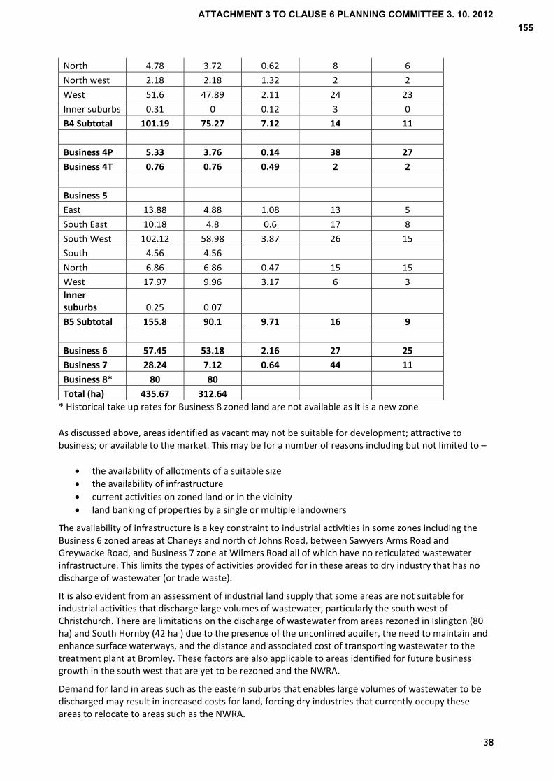
38
North 4.78 3.72 0.62 8 6
North west 2.18 2.18 1.32 2 2
West 51.6 47.89 2.11 24 23
Inner suburbs 0.31 0 0.12 3 0
B4 Subtotal 101.19 75.27 7.12 14 11
Business 4P 5.33 3.76 0.14 38 27
Business 4T 0.76 0.76 0.49 2 2
Business 5
East 13.88 4.88 1.08 13 5
South East 10.18 4.8 0.6 17 8
South West 102.12 58.98 3.87 26 15
South 4.56 4.56
North 6.86 6.86 0.47 15 15
West 17.97 9.96 3.17 6 3
Inner suburbs 0.25 0.07
B5 Subtotal 155.8 90.1 9.71 16 9
Business 6 57.45 53.18 2.16 27 25
Business 7 28.24 7.12 0.64 44 11
Business 8* 80 80
Total (ha) 435.67 312.64
* Historical take up rates for Business 8 zoned land are not available as it is a new zone
As discussed above, areas identified as vacant may not be suitable for development; attractive to business; or available to the market. This may be for a number of reasons including but not limited to –
the availability of allotments of a suitable size
the availability of infrastructure
current activities on zoned land or in the vicinity
land banking of properties by a single or multiple landowners
The availability of infrastructure is a key constraint to industrial activities in some zones including the Business 6 zoned areas at Chaneys and north of Johns Road, between Sawyers Arms Road and Greywacke Road, and Business 7 zone at Wilmers Road all of which have no reticulated wastewater infrastructure. This limits the types of activities provided for in these areas to dry industry that has no discharge of wastewater (or trade waste).
It is also evident from an assessment of industrial land supply that some areas are not suitable for industrial activities that discharge large volumes of wastewater, particularly the south west of Christchurch. There are limitations on the discharge of wastewater from areas rezoned in Islington (80 ha) and South Hornby (42 ha ) due to the presence of the unconfined aquifer, the need to maintain and enhance surface waterways, and the distance and associated cost of transporting wastewater to the treatment plant at Bromley. These factors are also applicable to areas identified for future business growth in the south west that are yet to be rezoned and the NWRA.
Demand for land in areas such as the eastern suburbs that enables large volumes of wastewater to be discharged may result in increased costs for land, forcing dry industries that currently occupy these areas to relocate to areas such as the NWRA.
ATTACHMENT 3 TO CLAUSE 6 PLANNING COMMITTEE 3. 10. 2012155
39
There is anecdotal evidence of increased demand for land in the west of the City as businesses need to relocate from eastern areas due to earthquake damage to land and/or buildings. There is also displaced demand expected from the inner suburbs as they reach capacity and undergo change to a mix of uses envisaged in the Central City Plan.
It is expected that the rebuild of Christchurch will result in demand from construction and manufacturing sectors for land. In the longer term growth is also anticipated in the machinery and equipment manufacturing sector, with specialised manufacturing firms such as Tait Electronics already exhibiting a strong presence on the edge of the NWRA at Wairakei Road. The greatest potential for growth can be achieved through the integration of agriculture, specialised engineering and ICT sectors according to a recent report on ‘Employment Opportunities in Canterbury’ (2011).
The airport is a significant node of economic activity directly adjacent to the NWRA that will generate demand for business land in the surrounding area including the NWRA, which is discussed below.
Having regard to the shortage of vacant industrial land in some areas and potential demand for industrial land, it is considered necessary to provide sufficient capacity for business growth in the North West.
The background report on business land identifies a number of strengths that make the NWRA appropriate for industrial business activities including its location adjacent to and accessible to the strategic road network (SH1 and SH73) and in close proximity to the airport for international markets and airport related business. This is reflected in the strong presence of transport, postal and warehousing, manufacturing, administrative and support services, and rental, hiring and real estate services in the surrounding area.
Other strengths of the NWRA for industrial business activities include ‐
A number of east west routes providing access to the Central City, suburban centres and other parts of the City
Existing industrial areas and a Technology Park on Wairakei Road, which could be extended and provide for efficiencies
Proximity to rural areas with potential demand from industries that depend on rural activities;
Bus routes that can be extended;
High levels of amenity for business
Ability to operate within the airport noise contour which constrains a number of other activities.
The suitability of different parts of the NWRA for industrial business activities is considered in Section 7.0.
‐ Christchurch International Airport
Christchurch International Airport is a significant node of economic activity. Future growth in passenger numbers and freight volumes, both domestic and international, will inevitably result in increased demand for land in the airport and in the surrounding area for airport related activities including cargo and freight, airline and airport related services e.g. car rental.
There will also be secondary benefits of growth in passenger and freight volumes for other industries that makes a location in close proximity to the airport attractive. Likewise, business development in close proximity to the airport will result in increased growth of the airport e.g. companies whose staff and/or customers are frequent travellers will contribute to growth in passenger numbers that has spin‐off effects for airport related activities.
The following provides an overview of the zoning of the airport as a Special Purpose zone and the role of Dakota Park in accommodating demand from airport and non‐airport related businesses.
ATTACHMENT 3 TO CLAUSE 6 PLANNING COMMITTEE 3. 10. 2012156
40
‐ Special Purpose (Airport) zone
The airport land (approximately 720 ha) is currently zoned Special Purpose (Airport) Zone (SPAZ), which provides for airport related activities, the zone’s purpose being for “activities clearly associated with operations and associated functions of the airport and aviation” (Section 1.3, Part 8 City Plan). There is a large quantum of vacant land in the Special Purpose Zone, which supports cargo and freight companies that would otherwise locate in industrial business areas of the City.
Reasons for rules limiting the scope of activities is to avoid the potential for pressure on the limited land resources available for airport activities within the zone and resultant pressure for expansion of the zone into the surrounding rural area.
In the Christchurch International Airport Master Plan 2006 (which is an external document, not incorporated into the City Plan), two areas are identified in the SPAZ for cargo and freight handling related activities (114 ha). One of these areas, Dakota Park (80 ha or 11% of the total area within the SPAZ), is undergoing development as a ‘Cargo and Freight zone’ (refer to Map 15). Access to Dakota Park is proposed direct from Russley Road (SH1), reflecting an agreement between Christchurch International Airport Limited and the NZTA.
Since July 2009, four applications for non‐airport related development in the SPAZ at Dakota Park have been granted, which reflects the demand from non‐airport related companies for a location close to the airport.
The most recent decision issued in August 2012 for a data storage facility in the SPAZ highlights the issue that has emerged of a range of business activities being sought within the airport that are not consistent with the purpose of the airport zone. The Commissioner stated that
“I note that almost all businesses probably make some use of the airport from time to time and this is not enough to bring them within the purpose and meaning of this zone. I have approved this application only because the area known as Dakota Park is such a small part of the airport itself, and an even smaller part of the business areas of Christchurch that it cannot possibly have a significant effect upon the integrity of the City Plan’s Business Objectives and Policies”
The Commissioner’s decision on the first application for two warehouses and ancillary offices (for RECALL) reached similar conclusions in stating that
“Effects on the environment will be minor… the proposal is not contrary to the objectives and policies of the plan viewed overall, the proposal has some synergy with (a) location near an airport and… involves only a small part of the overall zone”
The Commissioner noted that the zone’s purpose was not supported by ‘any clear objectives and policies for the zone’ and “if the Council wishes to “… prevent a wide range of activities … having little or no relationship to the airport, becoming established” in the SPAZ then it needs to amend its plan to include such a policy and to more clearly set out the objectives for the zone. It is not sufficient to rely on non zone policies to achieve that outcome”. Similar conclusions have been reached in subsequent decisions on resource consent applications in the “Cargo and Freight zone” at Dakota Park, which have all stated “The absence of a policy framework to justify the activities approach adopted for the airport provides no legal framework which would lead me (the Commissioner) to consider that it will undermine the integrity of the City Plan”.
Decisions have also indicated that a precedent has been established by the RECALL development, notwithstanding further applications for non‐airport related activities at the airport needing to be assessed on their own particular merits.
The most recent decision on an non‐airport activity in the SPAZ included an addendum from the Commissioner, which stated as follows ‐
“…At some point cumulative effects are going to become apparent. In my judgement that point has not been reached yet. It may well start to occur if CIAL starts to develop more of its site for business activities. I recommend that Council gives some consideration to this issue, and that these comments be forwarded to the Strategy and Planning Department of Council.”
ATTACHMENT 3 TO CLAUSE 6 PLANNING COMMITTEE 3. 10. 2012157
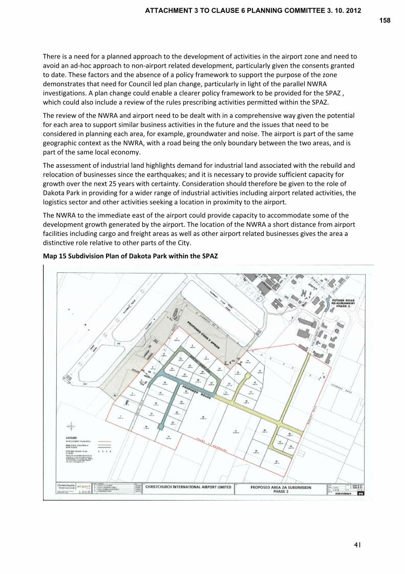
There is a need for a planned approach to the development of activities in the airport zone and need to avoid an ad‐hoc approach to non‐airport related development, particularly given the consents granted to date. These factors and the absence of a policy framework to support the purpose of the zone demonstrates that need for Council led plan change, particularly in light of the parallel NWRA investigations. A plan change could enable a clearer policy framework to be provided for the SPAZ , which could also include a review of the rules prescribing activities permitted within the SPAZ.
The review of the NWRA and airport need to be dealt with in a comprehensive way given the potential for each area to support similar business activities in the future and the issues that need to be considered in planning each area, for example, groundwater and noise. The airport is part of the same geographic context as the NWRA, with a road being the only boundary between the two areas, and is part of the same local economy.
The assessment of industrial land highlights demand for industrial land associated with the rebuild and relocation of businesses since the earthquakes; and it is necessary to provide sufficient capacity for growth over the next 25 years with certainty. Consideration should therefore be given to the role of Dakota Park in providing for a wider range of industrial activities including airport related activities, the logistics sector and other activities seeking a location in proximity to the airport.
The NWRA to the immediate east of the airport could provide capacity to accommodate some of the development growth generated by the airport. The location of the NWRA a short distance from airport facilities including cargo and freight areas as well as other airport related businesses gives the area a distinctive role relative to other parts of the City.
Map 15 Subdivision Plan of Dakota Park within the SPAZ
41
ATTACHMENT 3 TO CLAUSE 6 PLANNING COMMITTEE 3. 10. 2012158

42
Retail
The policy context of PC1 to the RPS (and Chapter 12A) and the City Plan provide a clear direction on the location of retail activities. PC1 identifies Key Activity Centres as the focal point for economic investment, business activities and the intensification of residential activities. Policy 5 of PC1 states that Council is to “ensure that commercial activity outside of the Key Activity Centres, other than local service activities, including local retailing, does not adversely affect the function, vitality or amenity of the Key Activity Centres …”.
A goal of the Recovery Strategy is to revitalise Greater Christchurch …by “planning for a well‐functioning Christchurch central City, thriving suburban centres …”, which is consistent with PC1/ Chapter 12A. The goal for economic recovery is supported by the vision of the Christchurch Central Recovery Plan that “Central Christchurch will become the thriving heart of an international city…”
The Central City is given primacy in the City Plan as the “principal focus for a diversity of business, accommodation, community and cultural activities” (Objective 12.2 Role of Central City). This is to encourage the consolidation of CBD activities including retail uses in the Central City to support its recovery.
The policy framework in the City Plan supports a centres based approach, objectives and policies encouraging consolidation in existing commercial centres while ensuring that the vitality and amenity of existing centres is not adversely affected by new retail activities in other locations (Objective 12.1 and policy 12.1.2 Distribution of Commercial Activity). The explanation to Policy 12.1.2 indicates that commercial activity outside of identified commercial centres has the potential to create adverse effects of both local and strategic (or wider) significance.
Objectives and policies on urban form (Section 4, Part 2) also support a pattern of land use that ‘promote and reinforce a close proximity and good accessibility between living, business and other employment areas’ through promoting the central city as a principal focus and larger district centres as a focal point for the consolidation of activities serving the needs of their surrounding communities.
There are a number of large centres serving the north west Christchurch including Riccarton, Papanui (Northlands) and Belfast (Northwood Supacentre). Due to the proximity of these centres, there is unlikely to be a need for a large quantum of retail activity in the NWRA. This is supported by an assessment of retail and commercial needs in Northern Christchurch for Plan Change 71 (Upper Styx residential greenfield area), which concludes that “Any new centre is most likely to serve a local/ neighbourhood centre function” (Market Economics 2012).
There are also a number of smaller centres including Avonhead Mall, Church Corner, Fendalton Mall; Ilam/Clyde shops; Wairakei Road shops and Bishopdale Mall. The background report on business land provides indicative catchments for these centres (See Map 16 on next page), which shows there is a sufficient distribution of retail centres across the north west.
The explanation to Objective 12.1 of the City Plan states “The function and amenity of the central city and district centres can be put at risk through the establishment of new retail activity which is similar in nature to that of the central city and district centres, and/or of significant individual or cumulative scale”. Using the Council’s retail gravity model, an assessment has concluded that a retail development5
in the NWRA would have an adverse effect on existing centres and therefore puts at risk the amenity of existing centres.
While growth areas are identified in the north west including Upper Styx and Masham areas, there is provision made or proposed for a local centre serving the needs of residents in these areas.
Therefore, it is not proposed to allow for retail activities in the NWRA or Dakota Park, unless it is ancillary to another activity e.g. café for workers in an industrial area.
5 Large format retail store of 2,000 m2 or supermarket and retail units of 2,800 m2
ATTACHMENT 3 TO CLAUSE 6 PLANNING COMMITTEE 3. 10. 2012159
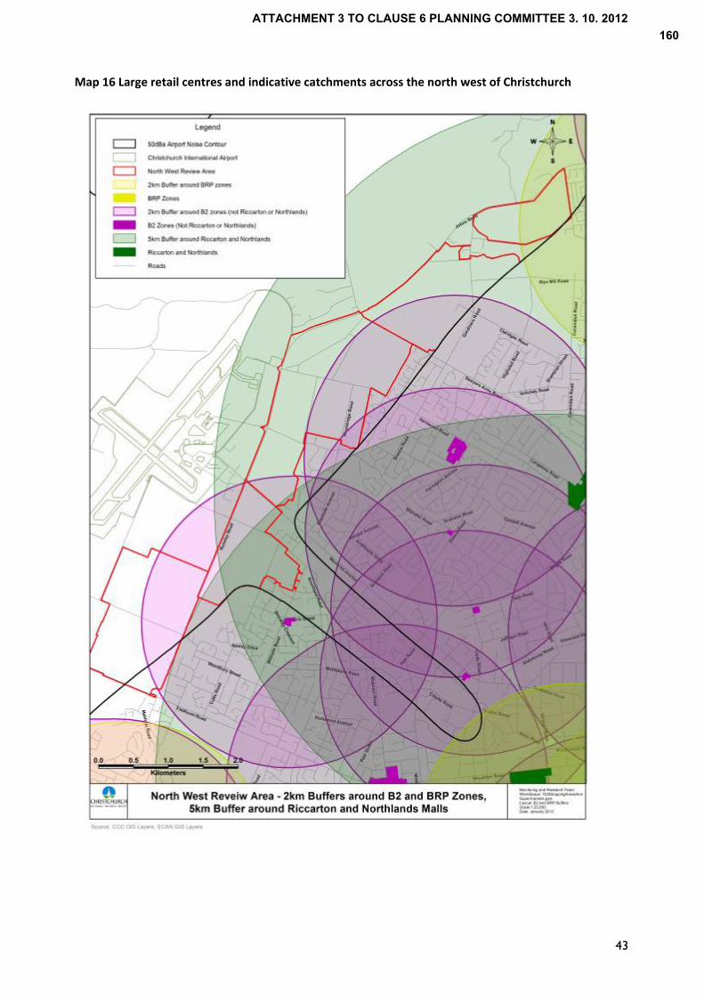
Map 16 Large retail centres and indicative catchments across the north west of Christchurch
43
ATTACHMENT 3 TO CLAUSE 6 PLANNING COMMITTEE 3. 10. 2012160
44
Office
The policy framework of PC1/ Chapter 12A and the City Plan identifies Key Activity Centres as the focus of ‘business and service activity’ and investment (Objective 5, PC1). A goal of the Recovery Strategy is to revitalise Greater Christchurch …by “planning for a well‐functioning Christchurch central City, thriving suburban centres …”, which is consistent with PC1/ Chapter 12A. The goal for economic recovery is supported by the vision of the Christchurch Central Recovery Plan that “Central Christchurch will become the thriving heart of an international city…”
The Central City is given primacy in the City Plan as the “principal focus for a diversity of business, accommodation, community and cultural activities” (Objective 12.2 Role of Central City) and it is envisaged that the Central City will be the principal area for employment in Greater Christchurch in the future.
Rules provide for offices in the Central City Business zone and place limitations on the scale of office development in the surrounding Mixed Use zone (City Plan as amended by the Christchurch Central Recovery Plan). This is to encourage the consolidation of CBD activities including offices in the Central City Business zone.
The City Plan also seeks the consolidation of commercial activities in existing commercial centres, ‘Commercial activity’ in this context including offices (Policy 12.1.2). Larger district centres also provide for a range of activities including offices, consistent with the centres based policy framework at a regional level.
While some industrial zones provide for a range of activities including offices, regard is to be had to the ”impacts on the continuing ability of the Central City and District centres to provide for the community’s social and economic well being” (City Plan, Section 12, Policy 12.10.1). In giving effect to this, the scale of offices is restricted in the heavier industrial zones i.e. offices are limited to an ancillary role in all industrial zones with the exception of the Business 3B, 4 and 4T zones.
There has been an increase in the use of industrial business areas for office space since the Christchurch earthquakes. Under the provisions of the Canterbury Earthquake (Resource Management Act Permitted Activities) Order 2011, offices can be established in industrial business zones until 2016. However, a number of office based companies will continue to locate in the Business 3B, 4 and 4T zones. A review of the policy framework for offices in the post‐earthquake environment may be appropriate, particularly given the potential for a shortage of supply in industrial zones. This may be due in part to a significant amount of land being occupied by offices.
In summary, it is not considered appropriate for offices to be located within the NWRA or Dakota Park in recognition of the role of the Central City and suburban centres as the focus of business development and investment. The development of offices in the NWRA could otherwise compromise the recovery of these centres.
Rural business activities
The City Plan does not currently distinguish between businesses that benefit from a rural location (but are not defined as a ‘rural activity’ in the City Plan) and business activities in an urban context.
The NWRA could provide for business activities in the rural zones of the NWRA that support agricultural and horticultural activities in a similar manner to the notified version of Proposed Plan Change 66, which includes the following definition of ‘rural activity’ ‐
“…businesses, research facilities and laboratories that support agriculture and horticulture activities through processing, producing, or providing goods or services directly necessary to agriculture and horticulture”
This could lead to unplanned and potentially fragmented development across the NWRA, a much larger area than the Templeton Special Purpose zone. It is considered more appropriate that ‘rural business activities’ are directed to areas identified for business in the NWRA. This supports the consolidation of
ATTACHMENT 3 TO CLAUSE 6 PLANNING COMMITTEE 3. 10. 2012161
45
business activities as well as providing benefits in terms of servicing and may lead to economies of agglomeration.
6.2 Noise sensitive activities
Policy 12 of PC1 in making reference to STA1 refers to the ‘area affected by airport noise’. In the wider context of a review of land for development (Policy 16(e) of PC1), noise sensitive activities within the 50 dBA Ldn noise contour are to be managed so as to not compromise the operation of Christchurch International Airport. PC1 defines noise sensitive activities as
• Residential activities other than those in conjunction with rural activities that comply with the rules in the relevant district plan as at 23 August 2008; • Education activities including pre‐school places or premises, but not including flight training, trade training or other industry related training facilities located within the Special Purpose (Airport) Zone in the Christchurch District Plan or on other land used or available for business activities; • Travellers accommodation except that which is designed, constructed and operated to a standard that mitigates the effects of noise on occupants; • Hospitals, healthcare facilities and any elderly persons housing or complex.
The definition was carried through into Chapter 22 inserted into the Operative RPS by the Minister of Earthquake Recovery. Policy 2 of that document sought “to avoid noise sensitive activities within the 50 dBA Ldn air noise contour around Christchurch International Airport except as provided for by Policy 1: Kaiapoi”. The City Plan seeks to ‘discourage noise‐sensitive activities within the 50 dBA Ldn noise contour around Christchurch International Airport’ (Policy 6.3A.7). The explanation to the policy states that ‘in general, the 50 dBA Ldn contour should mark the limit of noise sensitive activities in the direction of Christchurch International Airport. Between 50 dBA Ldn and the Air Noise Boundary the establishment of residential activities and the establishment and/or extension of other noise‐sensitive activities will be discouraged’. The explanation goes on to note that ‘In the Christchurch context it is not necessary to permit urban residential development to occur on land within the 50 dBA Ldn contour as sufficient land for residential expansion can be provided at other locations’. To support this policy, the minimum allotment size for subdivision and residential density purposes is 4 ha, which effectively limits residential development to a scale typical of the current environment. Having regard to the policy context, residential, education and health facilities are not considered to be appropriate in the NWRA. If there was a change to the airport noise contour, there would be a need to review the appropriateness of the NWRA for residential activities. However, there is considered to be sufficient land identified in PC1/ Chapter 12A to accommodate long term household growth.
ATTACHMENT 3 TO CLAUSE 6 PLANNING COMMITTEE 3. 10. 2012162
46
6.3 Travellers/ visitor accommodation
As stated earlier, travellers accommodation falls within the definition of a ‘Noise Sensitive Activities’ in PC1, which are to be avoided in the area referred to as the North West Review Area. An exception is made if Travellers accommodation is “designed, constructed and operated to a standard that mitigates the effects of noise on occupant”. In the absence of a definition in PC1, the City Plan defines ‘Travellers Accommodation’ as “transient residential accommodation offered for a daily tariff (and) … includes motels, holiday flats, motor and tourist lodges and hostels”. The Recovery Strategy seeks to revitalise Greater Christchurch …by “planning for a well‐functioning Christchurch central City (and) thriving suburban centres …”. This goal for economic recovery is supported by the vision of the Christchurch Central Recovery Plan that “Central Christchurch will become the thriving heart of an international city…”. To support these goals, the Central City is considered to be the “principal focus for a diversity of business, accommodation, community and cultural activities” (Objective 12.2 Role of Central City, City Plan). The scale of activities envisaged through the Central City Plan and the development potential of larger sites makes the central city more suitable for hotels. While the Central City is the focal point for visitor accommodation, the City Plan also enables travellers accommodation in specific locations adjacent to arterial or collector roads that are accessible to the Central City or sites where travellers accommodation has previously been established. Although the NWRA is adjacent to a number of arterial roads and there is currently travellers accommodation in the vicinity of NWRA, it is not considered to be an appropriate location having regard to the policy context which encourages visitor accommodation in the City Centre or in locations easily accessible to the City. To allow travellers/ visitors accommodation in the NWRA could potentially compromise the recovery of the Central City and suburban centres. Notwithstanding the current policy framework, the airport may be suitable for small scale visitor accommodation that needs to be on airport land. However, this requires further consideration in conjunction with review of the SPAZ.
6.4 Rural residential
PC1/ Chapter 12A of the RPS provides for rural residential development to a limited extent in Selwyn and Waimakariri Districts with no provision for Christchurch City. The same approach was taken in Chapter 12A as inserted into the Operative RPS by the Minister of Earthquake Recovery.
‘Rural Residential’ is defined as “Residential units outside the Urban Limits at an average density of no less than one per hectare” (PC1/ Chapter 12A). The NWRA is within the urban limits in PC1 and outside the urban limits in Chapter 12A should the latter be reinstated.
Irrespective of the outcome of appeals, the development of residential activities at a higher density could compromise the operation of the airport having regard to the 50 dBA Ldn airport noise contour.
Rural residential activities are required to be serviced by reticulated infrastructure in accordance with PC1. The potential cost of servicing large areas of the NWRA and efficiency of servicing this form of development over a large area means it is not considered appropriate to enable rural residential development.
Notwithstanding the points above, the NWRA currently provides for rural lifestyle development with a range of lots sizes, from less than 1 ha up to 20 ha. This enables people to live in a rural environment while being in close proximity to the City and achieves a more appropriate outcome, consistent with the RMA’s purpose of managing natural and physical resources. For these reasons, rural residential is not considered appropriate in the NWRA.
ATTACHMENT 3 TO CLAUSE 6 PLANNING COMMITTEE 3. 10. 2012163

47
6.5 Community facility/ meeting venue
There are a number of community facilities in the NWRA serving the population in the wider north west of the City. This includes a primary school and church on Harewood Road close to the intersection with Johns Road. Chapter 12A seeks to ensure community facilities are accessible, both to areas of residential intensification and Greenfield development. Blocks B and D of the NWRA adjoin areas identified for greenfield residential development, and intensification may occur in areas adjoining other parts of the NWRA. Consequently the provision of community facilities and open space in the NWRA to serve these populations may be appropriate.
6.6 Open Space There is a variety of existing open spaces within or in close proximity to the NWRA, the majority of which is in neighbouring residential areas to the east. The existing open spaces are typical of metropolitan Christchurch with numerous small neighbourhood parks for recreation, access, aesthetic values, and stormwater management.
Within the NWRA there are three large areas of open space held by the Council as reserve, being Nunweek Park (Block C, 19.6ha), Harewood Park (Council nursery, Block D, 11.2ha) and Smacks Creek Riverbank Reserve (Block D, 1.1ha). Waimairi Pit is also currently gazetted as Christchurch City Council reserve, but is to be returned to the Crown and its future use is not known.
The Council is currently undertaking a review of sports land or playing fields. The draft Outdoor Sports Land Plan proposes the creation of additional large parks around the city for sport and recreation. The plan notes Burnside Park as an existing large hub park serving the west of the city and may identify the need for an additional large hub park in the north west of the city. Areas within the NWRA could assist in meeting these open space requirements.
Outline development plans for new development areas should also identify opportunities for new open space in accordance with the Council’s Public Open Space Strategy, which should link where possible with riparian areas, particularly adjacent to the Styx River. The Public Open Space Strategy (POSS) identifies an area of open space deficiency between Avonhead Road, Memorial Ave and Wairakei Roads, which could benefit from open space provision in conjunction with development.
The POSS also identifies Russley/ Johns Road, Memorial Ave, Harewood Road and Sawyers Arms Road as road corridors for possible streetscape enhancement and planting. This would be appropriate in maintaining the character of the NWRA while also enhancing the area as viewed from the road. The role of the NWRA as a gateway is also recognised in the POSS, which identifies the intersection of Russley Road and Memorial Ave as having the potential to be designed to provide greater prominence to one of the City’s entry points.
6.7 Sport/Recreation
The current sport and recreational facilities in or in proximity to the NWRA include Nunweek Park, which currently serves as a hub for hockey, Avonhead Park, Burnside Park and Tullet Park.
A ‘Spaces and Places Plan for Sport and Recreation in Greater Christchurch’ (2012) has been prepared for Greater Christchurch that identifies the need for sport and recreational facilities and provides strategic direction for Christchurch City Council and other local authorities by identifying strategic hubs for sport and projects for the short, medium and long term.
ATTACHMENT 3 TO CLAUSE 6 PLANNING COMMITTEE 3. 10. 2012164
48
The projects identified in the plan include an all‐weather athletics track and a Class 2 athletics venue in the north west Christchurch. The report also indicates that a replacement Christchurch School of Gymnastics gym sports Centre could be located in the north west.
Aquatic facilities
An Aquatic Facilities Plan aims to provide a strategic direction for the maintenance, management and enhancement of Aquatic Facilities within Christchurch. This is currently subject to review in recognition of the changes to demographics and infrastructure since the earthquakes. It will identify facilities that need to be upgraded and where new facilities are required to meet future needs.
While subject to a review, the NWRA may be an appropriate location for aquatic facilities to serve the future needs of North West Christchurch.
6.8 Gravel Extraction
The NRRP seeks to avoid adverse effects on groundwater resources by limiting the amount of excavation that can occur if excavation is over 5 metres in depth or goes into groundwater in Protection Zones 1, 1A, 1C, 1D or 2. Given that Groundwater Protection Zones 1 and 2 extend over the majority of the NWRA, gravel extraction is not considered appropriate in the NWRA. Furthermore, provision is made for extraction in a specific area zoned for quarrying outside the NWRA.
6.9 Summary Having regard to the preceding evaluation of land uses, the NWRA is considered most appropriate for peri‐urban activities including active and passive open space, sport and recreational, and community facilities that serve the urban area. There is considered to be a need to identify up to 100 ha for industrial business purposes in the NWRA, which the most appropriate locations for are considered in the next section. Given the physical proximity of the NWRA to the airport and the consideration of business land issues, it is also appropriate to consider possible changes to the Special Purposes (Airport) zone in parallel so as to ensure an integrated resource management approach. In assessment of a range of land use activities, regard has been given the policy context, particularly for offices and retail, neither of which suitable in this location. Residential development would also not be compatible with the environment as the NWRA is within the 50 dBA Ldn airport noise contour within which noise sensitive activities are to be avoided. To allow residential activities could compromise the operation and development of the airport and may not support the retention of the character and amenity of the NWRA.
ATTACHMENT 3 TO CLAUSE 6 PLANNING COMMITTEE 3. 10. 2012165

49
7.0 Evaluation of the North West Review Area for Industrial Business activities
7.1 Introduction
This section considers the appropriateness of areas within the NWRA for industrial business activities having assessed the suitability of a range of land uses in the NWRA. For the purposes of evaluating the areas that make up the NWRA, 17 criteria have been identified, which are consistent with achieving a sustainable outcome for the NWRA.
7.2 Evaluation scores
Table 3 provide an assessment of each block and specific areas within each block against the criteria. Scoring is limited to a scale of 1 to 3,
0 indicating that an area does not meet the criteria,
1 indicating that an area meets the criteria in part, or a part of an area meets the criteria
2 indicating that an area meets the criteria
The second table (Table 4) that follows Table 3 assigns weighting to each score to reflect the relative importance of each criteria. A qualitative assessment of the different parts within the NWRA then follows, which provides the reasons for the scoring.
The weighting assigned to the criteria reflects the relative importance of one criterion to another, with 3 being the highest and 1 the lowest. It should be noted that a criterion with a weighting of 1 does not mean it is not important in itself but relative to other criteria it is of lesser importance.
The criteria given the highest weighting of 3 include the following, which reflects the strategic importance of the NWRA and the natural and physical resources in the area.
Contributes to consolidated urban form This reflects a key objective of the City Plan and in the context of the NWRA, there is a need to avoid sporadic development that could otherwise lead to inefficiencies in terms of servicing.
Compatible with maintaining the efficient operation of CIAL The location of the NWRA between the airport and urban area makes it strategically important in providing a buffer. It is important that the area facilitates the ongoing operation of the airport while protecting residents to the east.
Consistent with achieving protection of groundwater quality The groundwater resource is of strategic importance as it provides Christchurch with its drinking water. The protection of the aquifers is therefore of high importance in planning of the NWRA.
Ability to be serviced – wastewater/ water, and ability to manage stormwater The appropriateness of development in different parts of the NWRA is dependent on the feasibility of servicing that area, having regard to the potential constraints to infrastructure being extended. It is also important in the context of the NWRA as the ability to manage wastewater and stormwater enables protection of the groundwater resource.
While not considered to be of highest importance, a number of criteria are given a weighting of 2 or 1.5 to reflect their importance relative to other criteria. These include (weighting in brackets)
Absence of versatile soils/ limited potential for productive uses (2) The soils in the NWRA are highly versatile and productive, which are a significant resource in the context of Christchurch City. In considering areas for development, it is considered appropriate to retain soils where practicable. However, decisions on PC1 concluded it was not appropriate to
ATTACHMENT 3 TO CLAUSE 6 PLANNING COMMITTEE 3. 10. 2012166

50
leave the area exclusively in rural use having regard to constraints in the area and the criteria is therefore not given a higher weighting.
Location unlikely to give rise to reverse sensitivity effects (2) While business development in close proximity to residential areas enables walking and cycling, it can also give rise to reverse sensitivity effects if there is not separation or other appropriate treatment. Likewise, the same applies between rural and urban activities. In planning the future of the NWRA, there is a need to avoid locations that may otherwise compromise a business activity.
Absence of geotechnical constraints or other hazards including soil contamination, flooding (2) Having regard to hazards including liquefaction and flooding, there is a need to avoid development in areas that may otherwise be subject to adverse effects, ahead of mitigating any effects. The earthquakes of 2010 and 2011 have demonstrated the importance of considering hazards in the planning of development and that needs to be considered in the NWRA.
Ease of access to the strategic road network/ impact on the local road network (2) SH1 forms a boundary to the NWRA and the area is traversed by a number of radial routes that provides the NWRA with good access to the road network. This is beneficial for some businesses and is therefore a consideration in identifying the appropriate locations for developments.
Consistency with landscape, character and amenity values (1.5), ecological values (1.5), Tangata Whenua values (1.5) and heritage values (1.5) The natural and physical resources including the Styx River and character/ amenity of the area are important in the context of Christchurch City. The values (ecological, Tangata Whenua and amenity) of the Styx River and other waterways should therefore be retained. This is reflected in the weighting of these criteria that also recognises the area is not an ‘Outstanding Natural Landscape’ and does not have ‘Ecological Heritage Sites’.
The remaining criteria are factors to consider in assessing different areas but are not significant in determining the appropriateness of an area for industrial business activities. They include –
Close proximity to existing/ proposed residential areas – This enables walking and cycling due to close proximity between home and work.
Continuity with existing business zone(s) – Continuity with existing business areas is beneficial for business and the planning of infrastructure by supporting efficiencies.
Public Transport accessibility/ encourages walking and cycling – This is important to encouraging sustainable travel.
The qualitative assessment against each criteria that follows the Tables below provides more detail on how each area has been scored and considers the matters discussed above.
ATTACHMENT 3 TO CLAUSE 6 PLANNING COMMITTEE 3. 10. 2012167
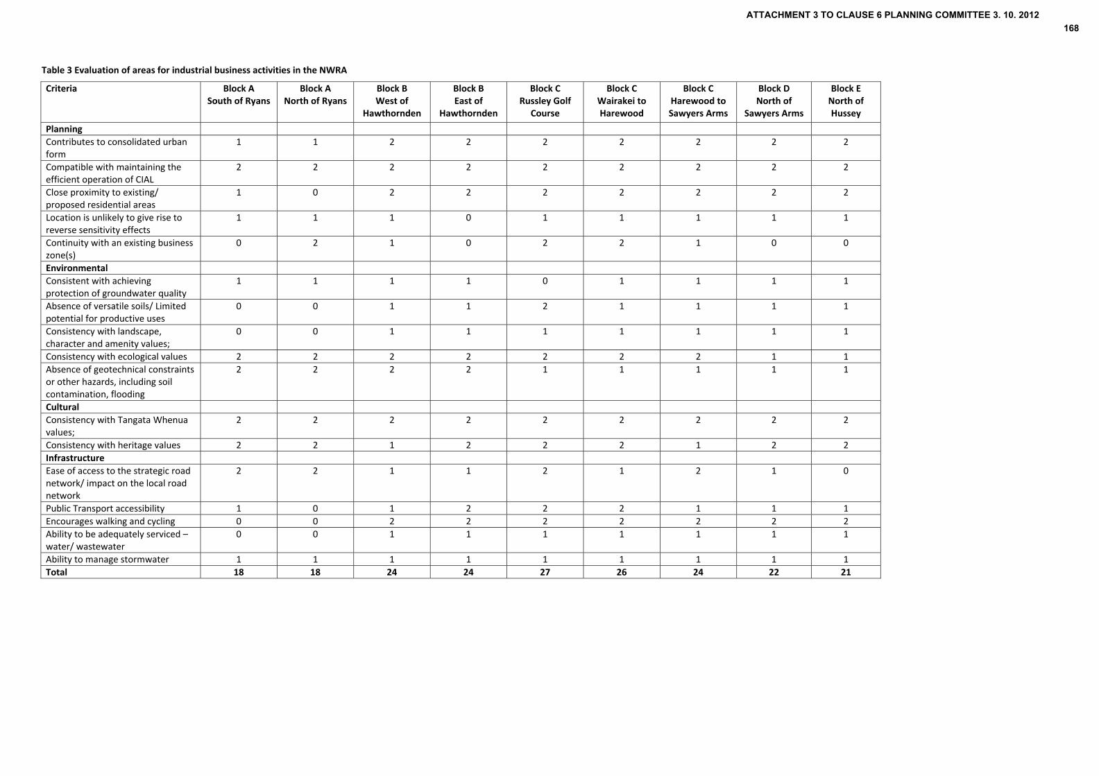
Table 3 Evaluation of areas for industrial business activities in the NWRA
Criteria Block A South of Ryans
Block A North of Ryans
Block B West of
Hawthornden
Block B East of
Hawthornden
Block C Russley Golf
Course
Block C Wairakei to Harewood
Block C Harewood to Sawyers Arms
Block D North of
Sawyers Arms
Block E North of Hussey
Planning
Contributes to consolidated urban form
1 1 2 2 2 2 2 2 2
Compatible with maintaining the efficient operation of CIAL
2 2 2 2 2 2 2 2 2
Close proximity to existing/ proposed residential areas
1 0 2 2 2 2 2 2 2
Location is unlikely to give rise to reverse sensitivity effects
1 1 1 0 1 1 1 1 1
Continuity with an existing business zone(s)
0 2 1 0 2 2 1 0 0
Environmental
Consistent with achieving protection of groundwater quality
1 1 1 1 0 1 1 1 1
Absence of versatile soils/ Limited potential for productive uses
0 0 1 1 2 1 1 1 1
Consistency with landscape, character and amenity values;
0 0 1 1 1 1 1 1 1
Consistency with ecological values 2 2 2 2 2 2 2 1 1
Absence of geotechnical constraints or other hazards, including soil contamination, flooding
2 2 2 2 1 1 1 1 1
Cultural
Consistency with Tangata Whenua values;
2 2 2 2 2 2 2 2 2
Consistency with heritage values 2 2 1 2 2 2 1 2 2
Infrastructure
Ease of access to the strategic road network/ impact on the local road network
2 2 1 1 2 1 2 1 0
Public Transport accessibility 1 0 1 2 2 2 1 1 1
Encourages walking and cycling 0 0 2 2 2 2 2 2 2
Ability to be adequately serviced – water/ wastewater
0 0 1 1 1 1 1 1 1
Ability to manage stormwater 1 1 1 1 1 1 1 1 1
Total 18 18 24 24 27 26 24 22 21
ATTACHMENT 3 TO CLAUSE 6 PLANNING COMMITTEE 3. 10. 2012168

52
Table 4 Evaluation of areas for industrial business activities in the NWRA with weighting
Criteria Weighting Block A South of Ryans
Block A North of Ryans
Block B West of
Hawthornden
Block B East of
Hawthornden
Block C Russley Golf
Course
Block C Wairakei to Harewood
Block C Harewood to Sawyers Arms
Block D North of Sawyers Arms Rd
Block E North of Hussey Rd
Planning
Contributes to consolidated urban form 3 3 3 6 6 6 6 6 6 6
Compatible with maintaining the efficient operation of CIAL
3 6 6 6 6 6 6 6 6 6
Close proximity to existing/ proposed residential areas
1 1 0 2 2 2 2 2 2 2
Location is unlikely to give rise to reverse sensitivity effects
2 2 2 2 0 2 2 2 2 2
Continuity with an existing business zone(s) 1 0 2 1 0 2 2 1 0 0
Environmental 0 0 0 0 0 0 0 0 0
Consistent with achieving protection of groundwater quality
3 3 3 3 3 0 3 3 3 3
Absence of versatile soils/ Limited potential for productive uses
2 0 0 2 2 4 2 2 2 2
Consistency with landscape, character and amenity values;
1.5 0 0 1.5 1.5 1.5 1.5 1.5 1.5 1.5
Consistency with ecological values 1.5 3 3 3 3 3 3 3 1.5 1.5
Absence of geotechnical constraints or other hazards, including soil contamination, flooding
2 4 4 4 4 2 2 2 2 2
Cultural 0 0 0 0 0 0 0 0 0
Consistency with Tangata Whenua values; 1.5 3 3 3 3 3 3 3 3 3
Consistency with heritage values 1.5 3 3 1.5 3 3 3 1.5 3 3
Infrastructure 0 0 0 0 0 0 0 0 0
Ease of access to the strategic road network/ impact on the local road network
2 4 4 2 2 4 2 4 2 0
Public Transport accessibility 1 1 0 1 2 2 2 1 1 1
Encourages walking and cycling 1 0 0 2 2 2 2 2 2 2
Ability to be adequately serviced – water/ wastewater
3 0 0 3 3 3 3 3 3 3
Ability to manage stormwater 3 3 3 3 3 3 3 3 3 3
Total 36 36 46 45.5 48.5 47.5 46 43 41
ATTACHMENT 3 TO CLAUSE 6 PLANNING COMMITTEE 3. 10. 2012169
53
7.3 Discussion
The following section provides an assessment of the blocks that make up the NWRA by criteria presented in the evaluative tables. This informs a quantitative assessment towards the end of this section that provides an overview of each area’s suitability for industrial business activities.
Planning
1. Contributes to consolidated urban form (contiguous with existing or proposed urban activities) Objective 6.1 in the City Plan seeks the consolidation of the urban area, the explanation stating that “consolidation does not necessarily entail containment of the City within its present urban boundaries, but does emphasise a compact pattern of development, in contrast to isolated and dispersed patterns of urban growth into what are currently rural areas”.
While the NWRA is defined within the urban limit in PC1 and the NWRA is bordered by urban activities, development should not compromise the objective of a consolidated urban form, therefore maintaining the contrast between the edge of urban activities and semi‐rural character of large parts of the NWRA consistent with Objective 4.1 (Form) of the City Plan. The development of activities adjacent to existing urban activities also provides for the more efficient provision of infrastructure. This is consistent with the outcome sought in the City Plan of “a productive city that provides for a wide range of business and employment opportunities and promotes the efficient use of the City's service and infrastructure”.
Block A while bound to the north by the SPAZ and south by the residential greenfield area, Masham, is to the west of Russley Road and is primarily rural in character with a dominance of agricultural and horticultural activities. While the airport and Business 6 zone contribute to an urban character west of Russley Road, Russley Road forms the western boundary to urban activities between Yaldhurst Road and Avonhead Park, supporting the consolidation of urban activities east of the State Highway.
Blocks B to E are all east of Russley Road/ Johns Road. The NWRA’s linear shape and proximity to the existing urban edge means that development in these blocks is less likely to compromise the objective of urban consolidation.
Having regard to the assessment, Block A is least preferred as an area for business or other urban activities. In other areas, development should be contiguous with existing or proposed urban activities, notwithstanding the assessment of the NWRA against other criteria.
Dakota Park, which forms part of the Special Purpose Zone, is under development as a business park and consideration should be given to a wider range of industrial activities as discussed in Section 6. Provision for non‐airport related business activities would be consistent with the objective of urban consolidation being adjacent to an existing developed area. The area already provides for industrial business activities similar in scale and nature to activities in existing industrial areas of the City and can meet short term demand for industrial land.
2. Compatible with maintaining the efficient operation of CIAL
Noise arising from the operation of Christchurch International Airport is a significant issue in identifying areas for future development within the NWRA. As discussed earlier, the function of the NWRA will continue to be as a buffer to avoid compromising the airport’s operation and future development. This is consistent with the decisions version of PC1 which uses the 50dBA Ldn airport noise contour as the appropriate boundary for restricting the location of noise sensitive activities.
With the exception of a small area (17 ha) at the intersection of Russley Road and Yaldhurst Road, the NWRA is within an area that lies within the 50dBA Ldn airport noise contour. Having regard to this, the
ATTACHMENT 3 TO CLAUSE 6 PLANNING COMMITTEE 3. 10. 2012170
54
subareas that make up the NWRA cannot be distinguished in terms of their compatibility with the airport’s ongoing operation and development.
3. Close proximity to existing and proposed residential areas
The explanation to Policy 3 (Business Land) of PC 1 states that “Locating appropriate business land close to existing and future residential development helps to achieve a greater range of travel options as well as reducing energy usage. Greater self‐sufficiency of employment within districts, suburbs and settlements is also desirable in terms of community development and social sustainability”.
Business activities in proximity to residential areas in the NWRA are beneficial for encouraging fewer vehicle trips. However, there is a need for the interface between business and residential areas to be carefully managed to avoid adverse effects including reverse sensitivity.
The adjoining land uses and zoning in the NWRA are described for each of the blocks in Section 2 of this report. As the NWRA adjoins the edge of the Christchurch urban area, all blocks are in the vicinity of existing or proposed residential areas. While facilities for cycling and walking are limited, the distance between the NWRA and adjoining urban areas encourages walking and cycling.
Although Block A is in proximity to residential areas, namely Masham (south of Yaldhurst Road) and Avonhead (east of Russley Road), it is bordered to the east and south by State Highways 1 and 73. This limits the opportunities for walking and cycling to Block A making it the least preferred location for business and other activities relative to other blocks in the NWRA.
4. Location is unlikely to give rise to reverse sensitivity effects
In considering suitable areas for business activities, there should be a sufficient area for development while providing separation from residential areas and rural activities. Although proximity to residential areas is beneficial in encouraging sustainable travel between home and work, if located too close, there can be adverse effects including reverse sensitivity. Likewise, development in close proximity to rural activities can lead to reverse sensitivity effects that compromise the ongoing operation of agricultural and horticultural land uses.
Block B east of Hawthornden Road is surrounded on three sides by residential properties and is a small area. Therefore a greater potential exists for conflict between business and residential activities.
Other areas while not constrained to the same extent, are interspersed by dwellings or clusters of residential properties (Corner of Wooldridge and Harewood Roads; Corner of Watsons Road and Waimakariri Road; Corner of Avonhead Road and Hawthornden Road). It is therefore important to carefully manage the interface between these areas. Other parts of the NWRA are in close proximity to rural activities given the predominant uses of the area at the current time are agricultural and horticultural activities. Block A, in particular, continues to support these activities given the larger lot sizes in this area.
5. Continuity with an existing business zone(s)
As discussed in the previous section, continuity with an existing or proposed business area can enable the interface with a new business zone to be more easily managed than a more sensitive land use activity such as residential.
There are also other benefits of existing and new businesses clustering together including ‘economies of agglomeration’, which is where costs of production may decline as a result of efficiencies, for example the use of the same suppliers. A number of businesses in the same industry operating close together can also attract more suppliers and customers than a single business.
ATTACHMENT 3 TO CLAUSE 6 PLANNING COMMITTEE 3. 10. 2012171
55
There are a number of existing business areas adjoining or in close proximity to the NWRA, which are considered as follows ‐
To the immediate north of Block A is ‘Dakota Park’ cargo and freight area, which is currently under development. There is the potential for a business area in the northern part of Block A to be contiguous with Dakota Park, notwithstanding the assessment of block A against other criteria.
Block B to the east of Russley Road is directly opposite Dakota Park, part of the SPAZ. There are no proposals for a road between Dakota Park and the area east of Russley Road so potential benefits are limited.
There is also a greenfield business area identified in PC1/ Chapter 12A between Avonhead Road and Memorial Ave (referred to as CB8 (Memorial Ave), which is subject to a plan change for rezoning. The Outline Development Plan submitted to the Council proposes access from Avonhead Road, which could provide benefits for a proposed business area in Block B.
Block C between Memorial Ave and Wairakei Road adjoins the Wairakei Technology Park accessed off Sir William Pickering Drive and Sheffield Crescent, which is zoned Business 4T in the City Plan. Land to the north of Wairakei Road between Wooldridge Road and Stanleys Road adjoins the existing Business 4 zone. Land adjoining these areas could therefore provide benefits for business while also supporting efficiencies in terms of servicing.
A draft plan change has been received by Council for rezoning land north of the existing Business 4 zone between Wooldridge Road and Stanleys Road to Business 4T. This is being led by Tait Electronics who propose a campus for consolidation of their business activities adjacent to their existing site at 558 Wairakei Road. This indicates a demand for additional business land in the area.
Blocks A – C are in close to Christchurch International Airport and accessible to the airport. As discussed earlier, the airport is a significant hub of economic activity, attracting businesses reliant on the Airport, that use air freight or have customers/ staff that frequently travel by air. This makes these parts of the NWRA attractive for business..
To the north west of Block C on the northern side of Johns Road is an area zoned Business 6. A business area between Harewood Road and Sawyers Arms Road within the NWRA could benefit from close proximity to this business area and the airport with access across Johns Road via Harewood Road and Sawyers Arms Road.
Environmental
6. Consistent with achieving protection of groundwater quality
As discussed in Section 3.3, the NRRP identifies ‘Christchurch Groundwater Protection Zones’, the most vulnerable parts of the groundwater system which are a principal source of drinking water for Christchurch City. The NWRA largely falls within Christchurch Groundwater Protection Zones 1 and 2. Table 5 below summarises the extent of the groundwater protection zones in each Block, which are shown on Map 17 on the next page.
ATTACHMENT 3 TO CLAUSE 6 PLANNING COMMITTEE 3. 10. 2012172

Table 5 Proportion (%) of Groundwater Protection Zones in each block
Block % of Groundwater Protection Zones in each Block
A 82% of block in Zone 1; 18% of block in Zone 2
B 76% of block in Zone 1; 24% of block in Zone 2
C 65% of block in Zone 1; 35% of block in Zone 2
D 38% of block in Zone 1; 62% of block in Zone 2
E 46% of block in Zone 1); 45% of block in Zone 2; 9% of block in Zone 3.
Map 17 Groundwater Protection Zones across the NWRA
B
C
D
E
A
56
ATTACHMENT 3 TO CLAUSE 6 PLANNING COMMITTEE 3. 10. 2012173

57
Zone 1 is an area of high intrinsic value and is particularly vulnerable due to the unconfined nature of underlying soils (permeable). Within Groundwater Protection Zone 1 a number of subzones are identified to facilitate the establishment and continuation of appropriate activities. As shown on Map 17, parts of the NWRA are within Groundwater Protection Zone 1A, which recognises that parts of Zone 1 are currently or planned to be used for urban purposes. This includes the southern part of Block B, northern part of Block D and western part of Block E. Zone 2 is where the aquifer transitions from unconfined to confined. Confining layers are typically shallow in depth or aquifer pressure is uncertain. Groundwater Protection Zone 2 provides greater flexibility than Zone 1 if adequate protection of the aquifer is provided, as a result of permanent upward pressure and a confining layer of at least 3 metres. The NRRP therefore has ‘reduced control’ on development in Zone 2 relative to Zone 1.
It is noted that only a small amount of the NWRA falls within Zone 3, which is the Groundwater Protection Zone with the least vulnerability due to the presence of confining layers between 3‐45 m thick.
Areas that are not within Groundwater Protection Zones 1 or 2 would be preferred locations for development. However, a small proportion of the NWRA falls within the less sensitive Groundwater Protection Zone 3.
Given the variation within individual blocks and the nature of the boundaries between one protection zone and another, it is difficult to suggest that one area is more favourable than another. It is on this basis that all areas are given the same score with the exception of Russley Golf Course, which is entirely within Groundwater Protection Zone 1.
It is clear that the Groundwater Protection Zones/recharge areas are an important consideration for proposed future development in the NWRA and that some types of activities (hazardous substance use and storage) will be inappropriate unless restrictions are imposed through the plan change process.
In summary the policy framework does not provide a significant constraint on development provided appropriate mitigation/avoidance of adverse effects and best practice management is implemented for any proposed development.
7. Versatile soils and potential for productive uses
The NWRA contains highly versatile soils, which have inherently high productive values. The majority of the NWRA has well drained soils and gravels/ hard soils tend to be at a deep level (45 cm or deeper), enabling digging and ploughing for agricultural/ horticultural activities. As shown on Map 18, the majority (86%) of the NWRA including all of Blocks A and B have moderate to highly versatile and productive soils.
Those areas with low versatility and productivity (approximately 120 ha) include
Block C (75ha)
o Land between Memorial Ave and Wairakei Road (Russley Golf course)
o Site of a former gravel pit north of Waimakariri Road
Block D (Johns Road) (34ha) – north and south west of Waimakariri Road
While recognising that the long term use of the NWRA for ongoing rural activities is not an ‘appropriate resource management treatment’ (Decision on PC1), the soils in the NWRA are a natural resource that are to be sustainably managed in accordance with the Resource Management Act. As stated earlier, an objective of the Proposed Regional Policy Statement (Objective 5.2.1) is for development to avoid adverse effects on significant natural and physical resources, the supporting explanation recognising the significance of primary production to the economic and social well being of people and communities and the need to maintain the primary production resource.
ATTACHMENT 3 TO CLAUSE 6 PLANNING COMMITTEE 3. 10. 2012174
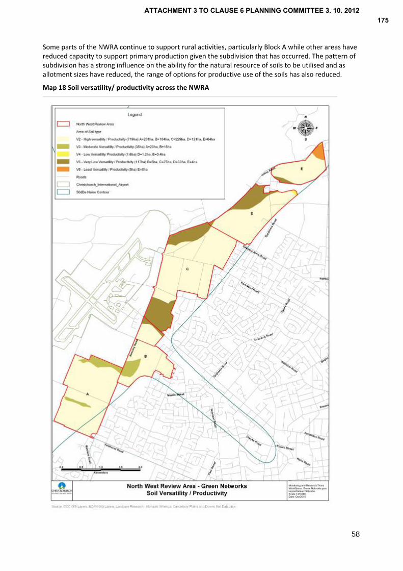
Some parts of the NWRA continue to support rural activities, particularly Block A while other areas have reduced capacity to support primary production given the subdivision that has occurred. The pattern of subdivision has a strong influence on the ability for the natural resource of soils to be utilised and as allotment sizes have reduced, the range of options for productive use of the soils has also reduced.
Map 18 Soil versatility/ productivity across the NWRA
58
ATTACHMENT 3 TO CLAUSE 6 PLANNING COMMITTEE 3. 10. 2012175

59
An assessment of the different areas across the NWRA in terms of soil versatility would suggest that the areas identified above with low versatility/ productivity would be most appropriate for development. While this is a factor to consider in comparing different areas, it is appropriate to also determine which areas are not appropriate for development having regard to the high versatility/ productivity of soils and that continue to provide large allotments for primary production. On this basis, Block A would be least appropriate as a location for development given its role in continuing to support rural activities, reflecting the soil quality and large allotments up to 24 ha with an average lot size of 4.7 ha.
Block E also continues to support rural activities and has larger lots up to 15 ha. While this is relatively small in the context of farms across the Canterbury Plains, these areas continue to support rural activities.
In respect of the other blocks within the NWRA, Block B comprises high quality soils, which support some agricultural activities between Russley Road and Hawthornden Road. However, its ongoing use for rural based activities is constrained by its location between the SH and Hawthornden Road. As discussed, increased urban activities in close proximity (CB8) greenfield business area north of Avonhead Road and CW1 Russley greenfield residential area west of Hawthornden Road) will limit the potential options for rural activities within this block in the long term.
Block D also has soils of high versatility/ productivity. However, the subdivision that has occurred within this block constrains the potential options for rural use, notwithstanding the current activities continuing in the future. The same comments apply to Area C with the exception of Russley Golf Course and Waimairi Pit north of Waimakariri Road, which comprise low quality soils.
8. Consistency with landscape, character and amenity values
The landscape of the NWRA reflects the land uses in the area with smaller allotments bordered by linear shelterbelts in areas used for agricultural and horticultural activities, and small random woodlots and groupings of exotic trees within the golf course and rural lifestyle blocks. However, some parts of the NWRA are more distinct from others as described below.
Block A has large open paddocks supporting pasture and crops. The tree cover in this area is less than other areas giving the area a more open character, which links well to the pastoral character of the Canterbury Plains landscape towards the west. While overhead transmission lines that cross Block A create an intrusion in the landscape, there are distant views across to the Southern Alps to the west and the Port Hills to the south west, which contributes to the landscape values of Block A. In recognition of this, it is considered less appropriate for business or other development than other areas.
Block B varies in terms of its character reflecting the land use activities and surroundings. Land to the east of Hawthornden Road is surrounded by residential properties which creates an enclosed area that presents a constraint to non‐residential activities. The overhead transmission lines also cross through the eastern part of Block B, which creates a physical corridor through this area. Land to the south of Avonhead Road between Russley Road and Hawthornden Road comprises lifestyle blocks up to 8 ha in size, with large homes positioned in the centre or towards the rear of sites. In contrast, the southern part of this block between Russley Road and Hawthornden Road has larger rectangular paddocks used for grazing which is reflected in a more rural character.
In Block C between Memorial Ave and Wairakei Road the tree cover reflects the layout of the golf course, which is surrounded by shelterbelts along three boundaries which effectively creates a green corridor along Russley Road and east along Memorial Ave.
North of Wairakei Road to Gardiners Road (Blocks C and D), small scale horticultural activities and lifestyle properties are heavily vegetated with shelter belts/ hedgerows creating a patchwork. Block E comprises a mix of activities including small rural lots and lifestyle blocks but unlike the majority of the NWRA, the topography of Block E is undulating.
ATTACHMENT 3 TO CLAUSE 6 PLANNING COMMITTEE 3. 10. 2012176
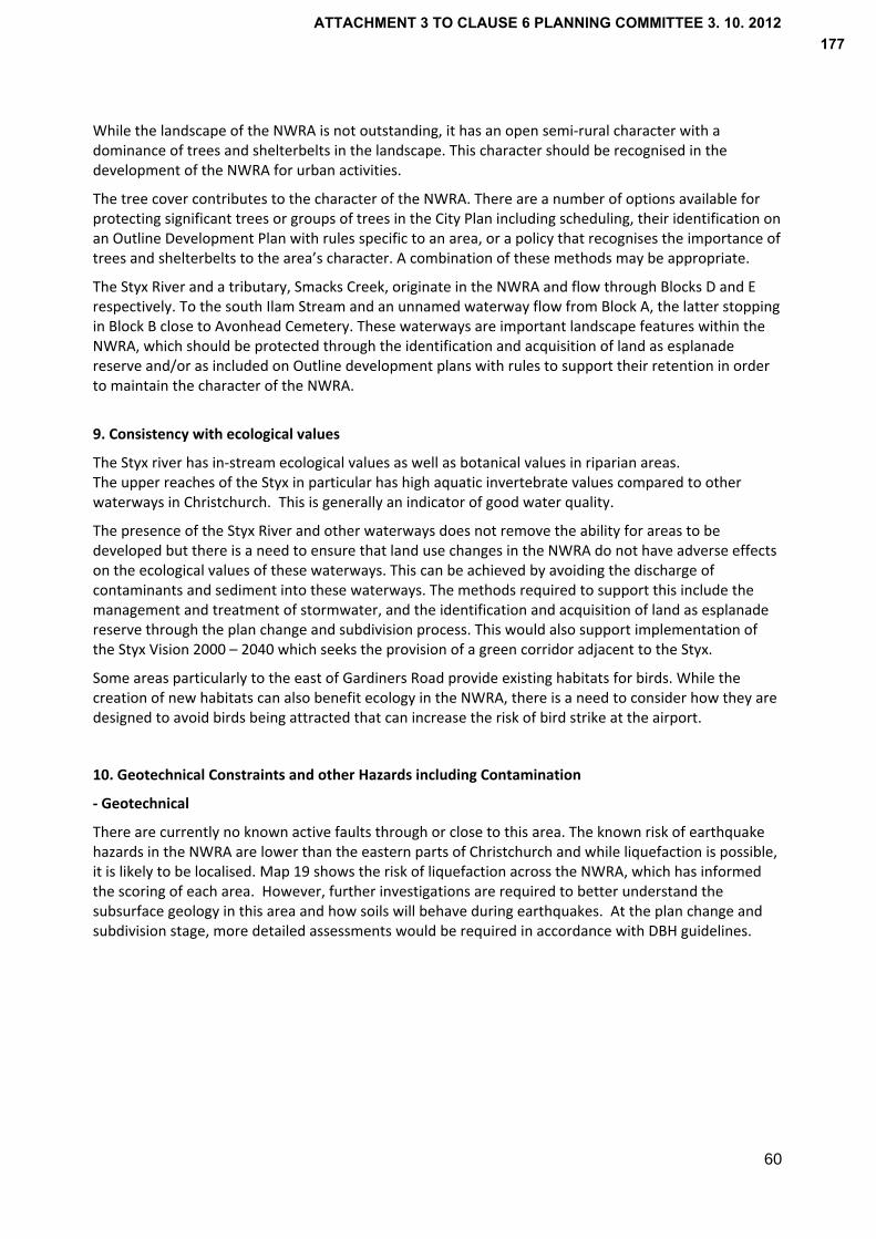
60
While the landscape of the NWRA is not outstanding, it has an open semi‐rural character with a dominance of trees and shelterbelts in the landscape. This character should be recognised in the development of the NWRA for urban activities.
The tree cover contributes to the character of the NWRA. There are a number of options available for protecting significant trees or groups of trees in the City Plan including scheduling, their identification on an Outline Development Plan with rules specific to an area, or a policy that recognises the importance of trees and shelterbelts to the area’s character. A combination of these methods may be appropriate.
The Styx River and a tributary, Smacks Creek, originate in the NWRA and flow through Blocks D and E respectively. To the south Ilam Stream and an unnamed waterway flow from Block A, the latter stopping in Block B close to Avonhead Cemetery. These waterways are important landscape features within the NWRA, which should be protected through the identification and acquisition of land as esplanade reserve and/or as included on Outline development plans with rules to support their retention in order to maintain the character of the NWRA.
9. Consistency with ecological values
The Styx river has in‐stream ecological values as well as botanical values in riparian areas. The upper reaches of the Styx in particular has high aquatic invertebrate values compared to other waterways in Christchurch. This is generally an indicator of good water quality.
The presence of the Styx River and other waterways does not remove the ability for areas to be developed but there is a need to ensure that land use changes in the NWRA do not have adverse effects on the ecological values of these waterways. This can be achieved by avoiding the discharge of contaminants and sediment into these waterways. The methods required to support this include the management and treatment of stormwater, and the identification and acquisition of land as esplanade reserve through the plan change and subdivision process. This would also support implementation of the Styx Vision 2000 – 2040 which seeks the provision of a green corridor adjacent to the Styx.
Some areas particularly to the east of Gardiners Road provide existing habitats for birds. While the creation of new habitats can also benefit ecology in the NWRA, there is a need to consider how they are designed to avoid birds being attracted that can increase the risk of bird strike at the airport.
10. Geotechnical Constraints and other Hazards including Contamination
‐ Geotechnical
There are currently no known active faults through or close to this area. The known risk of earthquake hazards in the NWRA are lower than the eastern parts of Christchurch and while liquefaction is possible, it is likely to be localised. Map 19 shows the risk of liquefaction across the NWRA, which has informed the scoring of each area. However, further investigations are required to better understand the subsurface geology in this area and how soils will behave during earthquakes. At the plan change and subdivision stage, more detailed assessments would be required in accordance with DBH guidelines.
ATTACHMENT 3 TO CLAUSE 6 PLANNING COMMITTEE 3. 10. 2012177
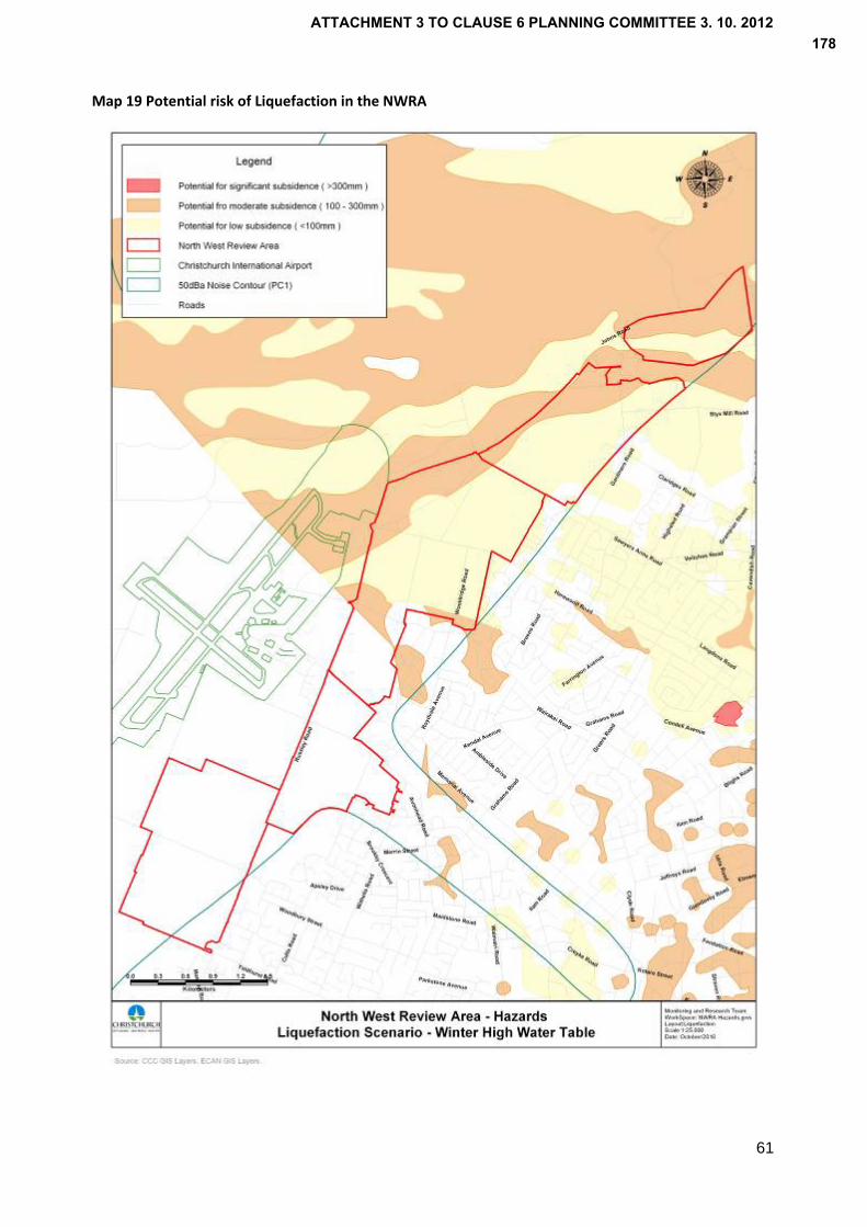
Map 19 Potential risk of Liquefaction in the NWRA
61
ATTACHMENT 3 TO CLAUSE 6 PLANNING COMMITTEE 3. 10. 2012178

62
‐ Flooding
The main source of potential flooding is the Waimakariri River. Existing flood mitigation works provide for protection up to a 1:2,000 year event. Secondary stop banks are being completed which will provide protection up to about a 1:10,000 year event. Consequently, it is considered that any risk of flooding, while an important consideration, is small in respect to development within the NWRA.
‐ Contaminated Sites
Information on contamination or potential contamination within the NWRA is limited. However, map 20 identifies the location of a number of existing or former activities, which are potentially contaminated sites. Activities that are known to have existed or continue in the NWRA include ‐
petrol and diesel tanks (Block C);
hard fill areas (Block C);
gravel deposits (Block D, though unlikely to be a source of contamination);
former gun club (Block E, potential lead contamination);
former timber treatment plant (Block E, organochlorine, arsenic salts, boron etc.);
septic tanks (all Blocks).
In addition, the following activities are or have been undertaken within or near the NWRA.
horticulture;
sawdust deposits;
remediated timber mill site;
concrete manufacturing plant.
ATTACHMENT 3 TO CLAUSE 6 PLANNING COMMITTEE 3. 10. 2012179

Map 20 Contaminated sites and activities in the NWRA
63
ATTACHMENT 3 TO CLAUSE 6 PLANNING COMMITTEE 3. 10. 2012180

64
All of the above listed activities, with the exception of septic tanks are on the Regional Council’s Hazardous Activities and Industries List (HAIL). Under the NES for Assessing and Managing Contaminants in Soils to Protect Human Health (2011), all of these sites (other than septic tanks) will require at least a preliminary investigation before any change of land use or subdivision can occur.
It should be noted that any site that has been, or could have been, subject to the migration of hazardous substances present in soil or water, is also considered a HAIL site. Contaminated sites adjacent to the NWRA are therefore a relevant consideration for future development.
Detailed investigations will need to be carried out at the plan change stage to determine the level of contamination on sites identified for development and the remediation/ management required.
Cultural
11. Consistency with Tangata Whenua values
There are no Ngai Tahu statutory acknowledgement areas. There are also no known silent files in the NWRA nor any archaeological sites based on Te Whakatau Kaupapa (1990). Similarly, the City Plan does not identify any archaeological sites or waahi tapu in the NWRA. However, there may be an archaeological site at the edge of the study area, near Gardiners Road (site M35/649) (ArchSite, New Zealand Archaeological Association database website).
While there are not known to be any specific sites of significant cultural value Ngäi Tahu may still have a historical or cultural relationship with the area. Key waterways including the Styx River may have been a source of mahinga kai, flax cultivation and harvest. Upstream wetlands of the Styx may have also been important for embalming.
The importance of maintaining and enhancing freshwater quality, the mauri and spiritual values of water and the maintenance and enhancement of wetlands need to be recognised in planning the future of the NWRA, and through the plan change process these values can be given recognition.
12. Consistency with heritage values
The City Plan identifies a number of buildings/sites of heritage value in the NWRA including
Block B
a large working barn off Russley Road (Group 3 protection status)
Hawthornden House at 2 Hawthornden Road (Group 3 protection status)
Block C
St James Church and graveyard at the intersection of Harewood and Waimakariri Roads (Group 3 protection status).
The City Plan provides protection for these buildings/ sites by requiring resource consent for any alterations, removal or demolition. The erection of a bulding on the site of a Group 3 heritage building also requires resource consent. Having regard to the potential effects that development may have on the setting of a site/ building, it is appropriate that areas identified for business are a sufficient distance from buildings/ sites of heritage value.
Infrastructure
13. Ease of access to the strategic road network and impact on the local road network
SH1 (Masham Road/ Russley Road/ Johns Road) forms the western boundary of the NWRA with the exception of Block A, which is to the west of the State Highway. SH1 is dissected by a series of radial
ATTACHMENT 3 TO CLAUSE 6 PLANNING COMMITTEE 3. 10. 2012181

65
roads that run in an east west direction towards the City Centre, suburban centres and the wider road network (including Memorial Avenue, Wairakei Road, Harewood Road and Sawyers Arms Road).
Other roads in the NWRA serve a local function and provide access to properties and access between arterial and collector roads. They include Ryans Road, Hawthornden Road, Stanleys Road, Wooldridge Road, Wilsons Road, Waimakariri Road, Wilkinsons Road and Hussey Road. All of these roads are sealed, but some are not formed to urban standards, which limits their ability to accommodate significant volumes of traffic unless they are upgraded.
The Western Corridor is one of a number of projects forming part of NZTA’s Roads of National Significant Programme, which involves the 4 laning of Masham Road/ Russley Road/ Johns Road and changes to intersections along Russley/ Johns Roads. Construction is in progress on upgrading the southern part of Russley Road, adjacent to Block A, and Masham Road. The upgrade of Russley Road between Harewood Road and Avonhead Park will be subject to a planning process under the Resource Management Act, which is expected to start in 2013. NZTA estimates that it may take 2 years to work through the process before construction, which would take a further 2 – 3 years.
Having regard to the closure or reduction in access between the State Highway and Avonhead Road, Wairakei Road, Gardiners Road and Wilkinsons Road, the RONS project influences the suitability of different parts of the NWRA for business. Existing access to properties directly from the State Highway or arterial roads may not be suitable if intensification or land use changes are proposed that increases the volume of traffic using that access. Access to local roads as an alternative to access from the State Highway or an arterial road may therefore be appropriate. The constraints in terms of accessibility and potential impacts on the local road network of additional trips arising from a new business area are considered below but would be subject to modelling at the plan change stage to determine the effects of development and the upgrades required to the road network. In assessing the effects, there is recognition of the increased traffic volumes in the north west of Christchurch associated with business activities that have relocated since the earthquakes and the impact of the RoNS proposals that result in increased volumes of traffic on local roads.
Block A (West of Russley Road)
This area has frontage to Russley Road (SH1) and Yaldhurst Road (SH73), both of which are Limited Access Roads. Consequently the most viable access to land within this block is from Ryans Road or via Grays Road.
As a part of the Western Corridor upgrade, access from Ryans Road will be reduced, removing the ability to turn right from Ryans Road onto Russley Road, southbound. For traffic wishing to travel south, there will be a need to use Pound Road via Ryans Road. State Highway 73 is also accessible via Pound Road to the west of Block A. Improvements to Pound Road will enable bypass traffic to more easily use this route between SH1 north of the airport and Templeton.
Grays Road, to the west of Block A is proposed to be connected to roads through Dakota Park, the airport’s business park to the immediate north of this block. This will enable vehicles to access SH1 via a proposed intersection. The NZTA propose a grade separated intersection that will connect Capital A and B roads (roads within Dakota Park) with Russley Road (SH1) via an underpass beneath Russley Road. This is subject to further investigations and planning processes under the Resource Management Act.
Having regard to these matters, Block A benefits from good access to the strategic road network at the current time and in the future, notwithstanding some access constraints.
Block B (South of Memorial Ave)
The area has frontage to Russley Road (SH1) and access is currently available from Block B to the State Highway via Avonhead Road. Avonhead Road is proposed to be closed as a part of the Western Corridor project, which will require vehicles from properties accessed off Hawthornden Road to travel via
ATTACHMENT 3 TO CLAUSE 6 PLANNING COMMITTEE 3. 10. 2012182

66
Avonhead Road and Roydvale Avenue onto Memorial Avenue or alternatively travel south on Withells or Avonhead Roads to access the State Highway network.
Dakota Park, the airport’s business park, is directly to the west of Block B. Access to Dakota Park is proposed directly from Russley Road (SH1) for north and south bound traffic. The NZTA propose a grade separated intersection that will connect Capital A and B roads (roads within Dakota Park) with Russley Road via an underpass beneath Russley Road. This requires land on the east side of Russley Road within Block B, which is subject to further investigations and planning processes under the Resource Management Act.
There is potential for access from a business area (in Block B) to the State Highway via the proposed intersection of Capital A and B roads and Russley Road. However, this would be subject to discussions with the NZTA.
To the north of Block B, the greenfield business area CB1 between Avonhead Road and Memorial Ave is subject to a plan change for rezoning. An Outline Development Plan indicates access through this block, which could also provide access to Block B as an alternative to travel via Roydvale Ave.
Having regard to the reduced access between Avonhead Road and SH1, a limited quantum of development may be appropriate ahead of upgrades to the local road network and intersections, necessitating a staged approach to development within this block. This could be dealt with through the plan change process.
Block C (Memorial Ave to Sawyers Arms Road)
Russley Golf Course between Memorial Ave and Wairakei Road currently has access from Memorial Ave via Stableford Green. This could continue to be the main entry to a future business area, subject to a more detailed assessment of the effects on properties fronting Stableford Green as part of a plan change. Alternative access could be provided to the site from Wairakei Road or a new connection to Sir William Pickering Drive in the adjoining Business 4T zone. Any proposal for the development of Russley Golf Course is likely to require upgrades to the local road network and intersections.
The area north of Wairakei Road has access to the State Highway via Wairakei Road and Harewood Road at the current time. Stanleys Road and Wooldridge Road both provide local access from Block C to Wairakei Road/ Harewood Road, which a new business area could gain access to.
Access is to be reduced from Wairakei Road to Russley Road. However, it will still provide good access between Block C and the State Highway in proximity to the Memorial Ave/ Russley Road interchange and airport. Harewood Road could also provide a suitable alternative for northbound access to the State Highway.
Reduced access at the intersection of Wairakei Road and Russley is likely to result in more vehicles using local roads between Memorial, Wairakei and Harewood Roads including Roydvale Ave and Wooldridge Road and/ or Stanleys Road. This is additional to increases in traffic volumes experienced since the earthquake with a number of businesses relocating to the north west around Wairakei Road, putting pressure on road capacity and car parking.
Local road improvements will be required to address changes in traffic movements, including the intersection of Wooldridge Road/ Harewood Road. The identification of an area for business north of Wairakei Road is likely to necessitate this and other improvements to the road network including Wooldridge and Stanleys Roads, subject to modelling of traffic effects at the plan change stage.
Between Harewood Road and Sawyers Arms, an area for business would be accessible to SH1 via either of these arterial routes as a part of current proposals for the Western Corridor. The Draft Christchurch Transport Plan proposes a new roading hierarchy, which identifies Sawyers Arms Road as a strategic route (known as 'District Arterial Routes").
ATTACHMENT 3 TO CLAUSE 6 PLANNING COMMITTEE 3. 10. 2012183
67
Waimakariri Road, which runs through this area, will have reduced access onto Sawyers Arms Road (left in/ left out) to minimise safety issues. However, access will continue to be available to the State Highway via Harewood or Sawyers Arms Road.
In summary, Block C currently has good access to the strategic road network. With the upgrade of the Western Corridor this will affect access between parts of this area and the State Highway. The effects of business development within this area would need to be modelled at the plan change stage to determine the improvements required to the road network and local intersections.
Block D (North of Sawyers Arms Road)
Block D has access to Gardiners Road, Sawyers Arms Road and Wilkinsons Road. Changes proposed as part of the Western Corridor upgrade will result in reduced access at the intersections of Johns Road/ Gardiners Road (limited to left entry into Gardiners from SH1, and left exit from Gardiners Road onto a lane parallel with SH1 to Wilkinsons Road) and Johns Road/Wilkinsons Road (Left entry out of Wilkinsons onto Johns Road). This will lead to increased vehicle movements on Gardiners Road additional to traffic generated by the residential development of CN3, which is currently subject to a draft plan change for rezoning.
Having regard to the changes and subsequent effects on Gardiners Road in particular, the most appropriate location for business activities would be off Sawyers Arms Road. However, its elevation in the hierarchy may result in limitations on access including increased separation distances between access points.
Block E (Hussey Road)
Block E is accessed off Hussey Road and Gardiners Road. Reduced access at Gardiners Road/ SH1 and Wilkinsons Road/ SH1 will require traffic generated by development within this area to travel south via Gardiners Road and west along Sawyers Arms Road, or alternatively to take a route through the residential area of Northwood in order to travel north. Neither route is short or direct, and therefore any intensification of land use activities in this area will result in some adverse effects on the local road network and surrounding environment, unless appropriately mitigated. This would necessitate upgrades to intersections including the junctions of Hussey/Gardiners Roads and the upgrade of Hussey Road.
A roundabout or grade separation is proposed at the junction of Clearwater Drive and Johns Road, however no new access is proposed immediately south through Block E. Having regard to proposed changes to the Western Corridor, this area is less accessible to the strategic road network.
Summary
The changes to the road network, particularly the RONS projects, will have significant implications for traffic movements and accessibility in the NWRA. Therefore, the upgrade of roads and intersections and planning of these improvements in conjunction with development in the north west is an important. Transport modelling at the plan change stage will enable the identification of works required to provide sufficient transport infrastructure capacity and ensure that the adverse effects of traffic can be mitigated, remedied or avoided.
14. Public Transport accessibility
A number of bus routes serve parts of the NWRA. Map 21 below shows the existing routes with buffers of 400 metres and 800 metres around each bus stop to indicate the areas that are within 5 – 10 minutes walking distance of a bus stop.
ATTACHMENT 3 TO CLAUSE 6 PLANNING COMMITTEE 3. 10. 2012184

68
The Council’s ‘Bus Stop Location Policy’ states “people will only walk around 400 metres or 5 minutes to a bus stop and that the distance they will walk depends on factors such as carrying bags, age, weather, topography, etc. The key is to try to have most households within 5 minutes walk of a bus stop”. Most areas of the NWRA are not within walking distance of a bus stop with the exception of the block between Memorial and Wairakei Roads, and an area to the immediate north of Wairakei and either side of Wooldridge Road. These locations are therefore more favourable for business activities as alternative transport options are available from residential areas. Changes to the public transport network are proposed by ECAN as published in the Draft Regional Public Transport Plan. This proposes a ‘hub and spoke’ network that will provide improved connections to suburban centres while also maintaining access to the central city. The effect of these changes on the assessment of areas for business is not significant.
ATTACHMENT 3 TO CLAUSE 6 PLANNING COMMITTEE 3. 10. 2012185
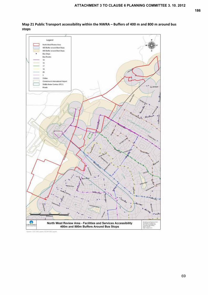
Map 21 Public Transport accessibility within the NWRA – Buffers of 400 m and 800 m around bus stops
69
ATTACHMENT 3 TO CLAUSE 6 PLANNING COMMITTEE 3. 10. 2012186
70
15. Walking/ cycling
There are currently limited opportunities for walking and cycling routes within the NWRA and between the area and the surrounding environment. This reflects the severance of land to the west by SH1, and the limited provision made for pedestrians and cyclists given the semi‐rural environment and formation of roads in the area.
The planning of areas for development provides an opportunity for the identification and development of routes for walking and cycling, enabling the greater use of these modes in the longer term. This can be achieved through the identification of walking and cycling routes on Outline Development Plans for areas identified for business.
The Draft Christchurch Transport Plan also proposes a cycle network for Christchurch, which identifies a major cycle route to the airport and local routes in the north west to encourage cycling. A walking network is also proposed that will encourage walking to/ from and within commercial centres and other areas of the City. The implementation of the plan will provide improved opportunities for these modes.
SH1 acts as barrier to cycling and walking between the NWRA and areas west of the State Highway. The NZTA is investigating cycle and pedestrian connections as part of the Western corridor project which may address this. However, decisions on these plans are yet to be made and therefore cannot inform the assessment of the suitability of areas in the NWRA for business activities.
Having regard to the severance of Block A on the west side of Russley Road it is given a lower score than other areas within the NWRA. Access to other areas can be enhanced as a part of development and due to the proximity of Blocks B, C, D and E to adjoining residential areas, people will be more willing to walk or cycle.
16. Ability to be adequately serviced
‐ Water Supply
The NWRA is located along the northern fringe of CCC’s north west water supply zone. There are currently issues in maintaining water supply pressure in some parts of the NWRA.
The infrastructure required to service a business development within the NWRA will depend on the nature of development and its location. Industrial business activities potentially have greater demands for water, which together with fire fighting requirements is likely to necessitate upgrades and new pump stations/ wells.
Having regard to the existing infrastructure provision, Block A to the north of Ryans Road is dependent on the extension of the water supply network from the area east of Russley Road. There are significant costs associated with this work and further investigation is required to determine the viability of extending the network. While the area of Block A south of Ryans Road has an existing connection to the network east of Russley Road, this would need to be upgraded at a significant cost.
If an area was identified within Block A as an extension of Dakota Park, which was led by Christchurch International Airport Limited, then there may be the potential for an extension of the airport’s water supply. However, this is not appropriate unless there was limited capacity for development within the airport’s land.
Block A is therefore not considered an appropriate area for business development having regard to these constraints. Other areas are more easily serviced given their proximity to the existing water supply network and the associated cost of extending the network. However, upgrades to the local network may still be required.
ATTACHMENT 3 TO CLAUSE 6 PLANNING COMMITTEE 3. 10. 2012187

71
‐ Wastewater
The wastewater catchments east of the NWRA areas are gravity catchments that flow east to Pump Station 1 (PS1) on Woodham Rd, from where the flows are pumped to the Bromley Wastewater Treatment Plant (WWTP). There are a number of trunk catchments and associated sub‐catchments that flow to PS1 and the relationship of these catchments to the NWRA areas are detailed in Table 6 below.
Table 6 Wastewater catchments for each Block
NWRA Block Trunk Catchment Sub‐Catchment
A Southern Relief Yaldhurst Rd Sewer Maidstone Sewer (Riccarton Interceptor)
B Southern Relief Riccarton Interceptor
C Northern Relief Wairakei Collector Sawyers Arms Collector
D Northern Relief Sawyers Arms Collector
E Northern Relief Eastern Trunk System
Northcote Collector
Belfast Sewer System
A Major Sewer Upgrade Programme is currently underway to reduce the number of overflows from the wastewater system into surface‐water bodies and to provide for future growth in greenfield areas. The Major Sewer Upgrade Programme incorporates a number of projects that influence the timing and ability for development to proceed in the NWRA.
Block A
This area is adjacent to the greater Southern Relief trunk sewer catchment and can be split into two sub‐catchments. The lower third of the area generally drains towards the sewer on Yaldhurst Road, which discharges directly into the upper Southern Relief trunk sewer. The upper two thirds of Block A generally drains towards Maidstone Road, part of the Riccarton Interceptor sub‐catchment, which in turn connects to the Southern Relief sewer at the Division Street/Blenheim Road junction.
Any development within the lower third of this block is dependent on the completion of the Western Interceptor trunk sewer. Once this is complete, developments in the lower third of Block A could connect into the Yaldhurst Rd sewer. The Yaldhurst sewer itself has available local capacity to convey flows from approximately 80 hectares of “dry industry” or 1000 new residential lots to the Southern Relief. Development of the upper two thirds of the site is reliant on the completion of the Maidstone project in order to create sufficient capacity in the Riccarton Interceptor to convey flow through to the Southern Relief. However, access to the sewer on Maidstone Road from Block A is a significant issue as third party agreement is required.
Block B
This area is entirely dependent on the Riccarton Interceptor to convey flows through to the Southern Relief sewer. Additional capacity in the main trunk system is dependent on completion of the Western Interceptor in 2012 and the Maidstone Project due for completion in 2017. The two local sewers that will convey flows from Block B are Merrin Street and Avonhead Road. Once the Maidstone project is complete, there is sufficient local capacity in these sewers to convey significant flows from Block B to the Riccarton Interceptor.
Block C
This area feeds into the Northern Relief trunk sewer catchment and is generally split in two sub‐catchments, with the lower half of Block C contributing to the Wairakei Collector sewer and the upper half of Block C contributing to the Sawyers Arms Collector sewer.
ATTACHMENT 3 TO CLAUSE 6 PLANNING COMMITTEE 3. 10. 2012188

72
The Northern Relief trunk sewer is undergoing a significant upgrade as part of the Major Sewer Upgrade Programme. This upgrade is still in the planning stage, and there still exists the possibility to take flows from the NWRA areas into account during design.
There is not sufficient capacity in the Wairakei Collector sewer to take significant additional flow from the NWRA block. A project known as the Wairakei Diversion will divert flows from the Northern Relief Trunk sewer catchment into the Western Interceptor. This will provide some additional capacity, but further work is required to establish what upgrades would be required.
There is no capacity available in the upper half of Block C on the assumption that the existing capacity in the Sawyers Arms Collector is taken up by connection of the “Upper Styx CN3”. Therefore additional upgrades would be required in order to convey flows from development in the upper half of Block C.
Block D
Block D is also served by the Sawyers Arms Collector and therefore any development in Area D would require upgrades to convey flows from this part of the NWRA.
Block E
Of all of the blocks, Block E is least able to be easily serviced and this is reflected in the scoring. Some of the eastern portion of the area may be able to be serviced via the Belfast wastewater system, but capacity is very limited due to the proposed residential development in the Belfast area. The balance of Block E could potentially be served by the Sawyers Arms Collector, but again this will also require upgrades to enable any development in this area.
Summary
Block B can be most readily serviced for wastewater discharge, but modelling will be required to determine the impacts of development on wastewater infrastructure at the plan change stage. Blocks C and D could be incorporated into the upgrades to the Northern Relief and further upgrades would need to be carried out to the local sewers in order to convey the wastewater flows from the development. Block E is the most challenging of the blocks to service from a wastewater perspective.
The scores for infrastructure serviceability in the evaluative tables largely reflect the extent to which the various blocks in the NWRA can be easily serviced with essential wastewater infrastructure upgrades. 17. Stormwater management
Soils in the bulk of the NWRA are suitable for stormwater soakage. However, as a large portion of the NWRA is located above the unconfined aquifer and the aquifer recharge area, extreme care must be taken to ensure that stormwater runoff is treated before infiltrating into the soil.
The NWRA is bordered in part to the west by Christchurch International Airport and the design of stormwater facilities therefore needs to recognise the potential attractiveness to birds, which could increase the risk of bird strike.
Under the Natural Resources Regional Plan (NRRP) (Rule WQL8) a resource consent is required for the discharge of stormwater onto or into land or into a river, lake or artifical watercourse under a Stormwater Management Plan (SMP). The purpose of SMPs is to state how a surface water catchment will be managed, protected, and if possible enhanced in the face of land use change. At the time of writing, Council was finalising an application to Canterbury Regional Council for resource consent for the discharge of stormwater from the Styx catchment. The Stormwater Management Plan forming part of this application has the objective of managing stormwater run‐off from rural and urban areas within the catchment by providing facilities to trap sediment and contaminants, and control the release of all stormwater into the river.
If a site(s) are identified in the Styx catchment for development, the stormwater from this may be accepted under Council’s application for resource consent to discharge stormwater from the Styx catchment or a new application to discharge stormwater will be required.
ATTACHMENT 3 TO CLAUSE 6 PLANNING COMMITTEE 3. 10. 2012189

73
In the future, an application will also be prepared for the discharge of stormwater from the Avon catchment. Therefore, any development within this catchment would require the approval of Council under an interim consent or a new consent would be required.
7.4 Appropriateness of areas within North West Review Area for Industrial business activities
The evaluation above has identified a number of areas that are more favourable for industrial business activities. The following provides a summary of each area, bringing together the preceding assessment against all criteria.
Block A Yaldhurst
The location of Block A west of Russley Road makes it less suitable in achieving the objective of urban consolidation. While north of Block A is the SPAZ and south is the Masham subdivision, Russley Road provides a clearly defined edge to the City.
The character of the area is unlike the rest of the NWRA with an open flat landscape and less tree cover, therefore providing views to the Southern Alps and Port Hills. The maintenance of character and amenity was a key message that came through in the consultation and therefore the openness of this block should be retained if there are more suitable locations elsewhere for business activities.
The area supports agricultural and horticultural activities on larger lots, the size and number of larger lots in Block A making it distinct from other areas. The decisions on Propose Change 1 concluded that subdivision had eroded the potential options for utilising the highly versatile soils, which is not considered to be applicable to this area.
In assessing the areas for business activities, the continuity with existing business areas was identified as a significant benefit in terms of infrastructure, urban form, and efficiency for business. To the north of Block A is an area under development as a business park, known as Dakota Park. A possibility would be an extension of the business area into Block A. However, there is considered to be a significant quantum of land available within the SPAZ to support future growth in airport related activities.
A constraint to the development of business in Block A is the need to extend water supply infrastructure from the east side of Russley Road and/or to undertake a major upgrade to an existing pipe serving the lower part of Block A. There would be a significant cost associated with this, making it less attractive as a location for development. The ability for a connection between Block A and the Maidstone sewer is also an issue given the need for third party agreement, which may constrain the potential development of this block.
Reflecting PC1, proximity to residential areas can be benefit in encouraging sustainable travel between home and the workplace. While there is a residential area to the south, Block A fronts two State Highways, therefore being less favourable in encouraging walking or cycling. However, its separation means there is less likelihood of reverse sensitivity effects.
Having regard to the matters above, Block A is not considered appropriate for industrial business activities. Its location west of the State Highway and as a gateway to the Canterbury Plains suggests that its ongoing use for rural activities is appropriate.
ATTACHMENT 3 TO CLAUSE 6 PLANNING COMMITTEE 3. 10. 2012190
74
Block B Hawthornden
Block B east of Russley and either side of Hawthornden benefits from a location adjacent to the existing urban area. The development of business activities within this block would therefore be consistent with achieving a consolidated urban form.
While largely within the 55 dBA Ldn noise contour, the land to the east of Hawthornden Road is less suitable for business activities as it is surrounded by residential properties on three sides which may give rise to reverse sensitivity effects. The area of land available is small and is in multiple titles, so while a small area could be identified for business, it is limited and buffers/landscaping required would constrain the quantum of land available.
The land to the west of Hawthornden Road can be separated into two parts. The north, closest to Avonhead Road comprises residential and lifestyle properties fronting Avonhead Road up to 8 hectares in size. Several properties have large homes positioned either in the centre or towards the rear limiting opportunities for subdivision and that may give rise to reverse sensitivity effects. There is also a heritage item, Hawthornden House at 2 Hawthornden Road.
The pattern of existing development differs in the central and southern portion of Block B west of Hawthornden Road. It comprises larger lots, which provides greater potential for development relative to the multiple ownership of an area with a large number of small lots. However, unlike Block A, options for ongoing rural production are constrained by its location.
The south western part of Block B is within Groundwater Protection Zone 2, which provides greater flexibility than Zone 1. However, the southern part of Block B is within Zone 1A which recognises a part of Zone 1 is currently or planned to be used for urban purposes. Having regard to this and the factors above, the lower half of Block B is considered appropriate for business development.
While access from Avonhead Road to Russley Road is to be closed as a part of NZTA’s plans for 4 laning Russley Road, there is existing access from Block B to Memorial Ave via Avonhead Road and Roydvale Ave. There is also potential for access in the future from Avonhead Road to Memorial Ave through the MAIL site (Corner Russley Road and Memorial Ave) identified for business activities in PC1, which could provide alternative access to Memorial Ave from this block. However, modelling results at the plan change stage will identify the upgrades required to the local road network and intersections and the quantum of business development that could occur ahead of these upgrades.
As discussed earlier, access is proposed to Dakota Park directly from Russley Road (SH1) for north and south bound traffic via a grade separated intersection This requires land on the east side of Russley Road within Block B, which is subject to further investigations and planning processes under the Resource Management Act. There is potential for access from a business area (in Block B) to the State Highway via the proposed intersection of Capital A and B roads and Russley Road. However, this would be subject to discussions with the NZTA.
The area west of Hawthornden Road is in close proximity to a residential area, supporting opportunities for walking and cycling between home and work, while also being adjacent to a greenfield business area between Avonhead Road and Memorial Ave. The size of the area is considered to be sufficient to provide a buffer and enable the mitigation of effects on adjoining residential areas.
In summary, Block B is considered to be a suitable location for industrial development. An area north of Avonhead Cemetery between Hawthornden Road and Russley Road is considered most suitable. It could enable links to open space (Avonhead Park) for amenity and recreation, and the land concerned is largely open pasture and there are therefore few buildings that act as a constraint to business development in this area.
The northern part of the block between Russley and Hawthornden Road has not been identified for business use on the basis that it includes number of residential properties that front Avonhead Road. The northern part of the block, closest to Avonhead Road is also within the air noise boundary, defined as the in the City Plan where noise levels are expected to be most intrusive. The area is within an area defined as an ‘Airport Protection Surface’ within which a height limit on buildings applies, and is to the
ATTACHMENT 3 TO CLAUSE 6 PLANNING COMMITTEE 3. 10. 2012191

75
immediate south west of the Runway End Protection Area (REPA). While these factors do not remove the potential for business development, it makes this area less favourable for development than the land further to the south. Block C – Russley Golf Course
The land between Memorial Ave and Wairakei Road has the highest score amongst the areas evaluated for industrial business activities. This reflects its location contiguous with the existing urban area, therefore supporting a consolidated urban form.
It adjoins the existing Business 4T zone, which has been identified through the review of supply as having a shortage of vacant land. This site could provide a natural extension of the zone and contribute towards addressing the need for additional land. The benefits associated with extending an existing business zone were discussed earlier but include potential ‘economics of agglomeration’, efficiencies in terms of servicing, and the interface between business zones being easier to manage than the boundary with a residential environment.
The land between Wairakei Road and Memorial Ave also benefits from proximity to residential areas, supporting opportunities for walking and cycling. In terms of access, there are a number of options including existing access to Memorial Ave or alternative access via the existing Business 4T zone or off Wairakei Road. The area also benefits from good access to public transport routes making it more favourable as a location for development.
In terms of natural and physical resources, the area has lower quality soils relative to the rest of the NWRA. However, it continues to be used as a golf course and is therefore unavailable for the foreseeable future. It is a not considered to be a suitable location for development unless its current use as a golf course ceased.
Block C – Wairakei to Harewood Road
The land north of Wairakei Road is split by Stanleys Road and Wooldridge Road. The land east of Wooldridge Road, Nunweek Park, is not considered appropriate for development, given its current use and the need for open space in the area (having regard to the deficiency of open space to the south of Wairakei Road).
The land between Wairakei Road and Harewood Road is partly within Groundwater Protection Zones 1 and 2. The Styx River also originates in the block west of Wooldridge Road, between Wairakei and Harewood Roads. Therefore adverse effects from development should be avoided to maintain the water quality of these natural resources and land identified as esplanade reserve adjacent to the Styx River , as appropriate, to retain/ enhance the natural character of the waterway.
The area benefits from access to the SH1 via Wairakei Road and Harewood Road. While access is to be reduced from Wairakei Road to Russley Road, it will still provide good access to the State Highway in proximity to the Memorial Ave/ Russley Road interchange and airport. Harewood Road could also provide a suitable alternative for northbound access to the State Highway. Traffic volumes have increased in the area with the relocation of businesses since the earthquakes. Modelling at the plan change stage will enable the identification of upgrades required to the local road network and intersections to enable additional business development in this area.
The land north of Wairakei Road is in proximity to residential areas, therefore supporting walking and cycling as well as having good public transport access relative to other areas in the NWRA with two bus routes along Wairakei Road.
This block is also in the immediate proximity of the airport, attracting business that has air freight requirements and staff/ customers who travel by air, notwithstanding the reduced access from Wairakei Road to SH1. There is also demand for business land north of Wairakei Road from Tait Electronics who are seeking to consolidate their business on a single site between Wooldridge Road and Stanleys Road
ATTACHMENT 3 TO CLAUSE 6 PLANNING COMMITTEE 3. 10. 2012192

76
to the north of their existing building while also providing for future growth. This is consistent with forecasts of significant growth in the electronic engineering sector.
The area identified by Tait is approximately 10 ha. Having regard to the potential demand for additional land as businesses in the supply chain or same industry as Tait seek a location in proximity, it is recommended that a larger area of approximately 50 ha is identified, extending north of the land proposed by Tait for rezoning and west to Russley Road. The appropriate boundary to development is considered to be the swale between Wooldridge Road and Stanleys Road that the Styx River originates from. This provides a natural boundary to the area in an otherwise modified environment. It also provides a buffer with residential units within the block and at the intersection of Wooldridge Road and Harewood Road. The extent of the area defined west of Stanleys is based on cadastral boundaries while aligning where possible with the former channel of the Styx River.
Block C – Harewood to Sawyers Arms Road
The land comprises a large number of small properties used for market gardening, nurseries and rural lifestyle activities. The multitude of property owners constrains the development of an area for business as does proximity to residential properties. While this is possibly true of land south of Harewood Road, there is an active party pursuing the development of business activities (Tait) in that area and landowners who have sought the identification of their land for business activities.
The block between Harewood and Sawyers Arms Road scored highly for similar reasons to the land between Wairakei Road and Harewood Road.
The western part of the block, north of Waimakariri Road has soils of very low versatility/ productivity, which reflects the former use of this land as a gravel pit, currently gazetted for this purpose. Part of this site is proposed for an electrical substation under an exchange agreement between Christchurch City Council and Orion. The balance some 13.9 hectares is to be returned to the Crown in the future, reflecting a previous Council decision. The size of the block and its access to Sawyers Arms Road and Harewood Road via Waimakariri Road would support a comprehensive business development. It is also adjacent to a Business 6 zone on the north side of Johns Road, which is accessible via Sawyers Arms Road.
With regard to the balance of the land between Harewood Road and Sawyers Arms Road, the subdivision pattern and activities including lifestyle sections makes this area less suitable and it is therefore not recommended as a business location.
Block D Johns Road
Block D north of Sawyers Arms Road is bordered to the east by rural properties, which in time will be developed as part of a wider greenfield residential area identified in PC1/ Chapter 12A. However, the identification of land for business activities in Block D would not support the objective of urban consolidation until such time that land to the east is developed.
While the area to the immediate north and south of Wilkinsons Road has soils of low versatility/ productivity and the area north of Wilkinsons Road is within Groundwater Protection Zone 1A (which provides for existing or proposed urban activities), the development of business activities in the northern part of Block D is constrained by existing land uses including Harewood Park, Christchurch City Council’s nursery, which takes up a large portion of the land to the immediate south of Wilkinsons Road and Harewood Crematorium
Like the area between Harewood Road and Sawyers Arms Road, there is a mix of horticultural activities and lifestyle blocks in the southern and western parts of Block D. The multitude of owners potentially constrains the ability for a comprehensive business development and there is potential for reverse sensitivity effects due to lifestyle properties in the area.
ATTACHMENT 3 TO CLAUSE 6 PLANNING COMMITTEE 3. 10. 2012193

77
The Styx River flows through Block D to the north east across Gardiners Road. Any land use changes or development in proximity of the Styx would need to be carefully managed to avoid adverse effects on water quality, the natural character of this area, ecological and Tangata Whenua values.
The western and southern parts of the Block are within Groundwater Protection Zone 1, the balance being in Zone 2. Like other areas in the NWRA, development would need to be managed to avoid adverse effects on the groundwater resource.
As a part of the upgrade of the Western Corridor, access will be reduced at the intersections of Gardiners Road and Wilkinsons Road, which makes the northern part of the block less favourable. In addition, it is expected that Styx Mill Road and Gardiners Road will come under increased pressure from traffic associated with the greenfield residential area to the east of Gardiners Road.
The area does not adjoin an existing business zone and is also not served as well as other areas by public transport. While the development of other areas requires upgrades to the local sewer network, additional capacity is required to service Block D, which diminishes the potential for development until the medium term. Having regard to these factors, it is not recommended for business.
Block E Hussey Road
Block E is occupied by rural lifestyle blocks and is surrounded to the east and south west by residential properties. While there is sufficient separation from residential properties, the potential for reverse sensitivity effects exists.
Access from Block E to the strategic road network via Gardiners Road and Wilkinsons Road is to be reduced, which will necessitate travel south via Gardiners Road/ Sawyers Arms Road to SH1 or alternatively through Northwood.
While the area has lower quality soils to the north east and an area in Groundwater Protection Zone 3, there is a higher risk of liquefaction in Block E than other areas. Block E is also the most difficult to service in terms of wastewater infrastructure and is not in proximity to a business zone. It is therefore not a favourable location relative to other Blocks.
Summary
From the assessment, it is recommended that three areas are identified for the development of business activities
Land at 711 Johns Road, north of Waimakariri Road (Area 1) comprising approximately 15 ha;
Land north of Wairakei Road, between Wooldridge Road and Russley Road (Area 2), comprising approximately 50 ha;
Land between Hawthornden Road and Russley Road (Area 3), comprising approximately 35 ha.
These areas are shown on Map 1.
7.5 Types of business activity
The evaluation indicates a number of areas suitable for business, which could support a range of industries. The area north of Wairakei Road has been identified in part because it adjoins an existing Business 4 and 4T zones and could provide an extension to these areas.
The Business 4 (Suburban Industrial) provides principally for light industry, warehousing and service industries and some commercial activities such as offices and limited retailing. The Business 4T zone provides for a similar range of activities although its intended purpose is as a technology park with an emphasis on maintaining a higher standard of amenity than in other business zones.
ATTACHMENT 3 TO CLAUSE 6 PLANNING COMMITTEE 3. 10. 2012194
78
Given the residential environment in close proximity to Block B, the types of industrial activities anticipated in the Business 4 or 4T zone would be most appropriate in this location as well.
Having regard to the natural resources of the NWRA including the majority of the NWRA being within Groundwater Protection Zone 1, only “dry” industrial activities are considered to be suitable, being those that do not involve the use or storage of large volumes of hazardous substances or generate large volumes of trade waste. This would be consistent with the purpose of the Business 4/ 4T zones, notwithstanding the need for specific standards to control the use or storage of hazardous substances and discharges.
ATTACHMENT 3 TO CLAUSE 6 PLANNING COMMITTEE 3. 10. 2012195
79
8.0 Conclusions The purpose of this report has been to determine the appropriate function of the NWRA and land use activities that would be consistent with this function. In doing so, consideration has been given to the policy context including the RMA’s purpose of the sustainable management of natural and physical resources while providing for the social and economic wellbeing of people and communities.
The objectives of statutory documents including the Regional Policy Statement, Natural Resources Regional Plan and City Plan recognise the importance of protecting natural and physical resources including the versatile soils, groundwater resource, surface waterways and airport as a strategic resource. This is to be achieved through urban consolidation, avoiding noise sensitive activities in the NWRA, retaining areas of highly versatile and productive soils, avoiding or mitigating the effects of activities on groundwater (e.g. use and storage of hazardous substances), and managing and treating stormwater before discharge to surface waterways such as the Styx amongst a range of methods.
In recognition of the natural and physical resources of the area, it’s location bordered to the immediate west by the airport and east by the urban area, and as a strategic corridor and gateway to the City, it’s function is considered to be as a ‘Rural‐Urban Fringe’ that provides for activities typically associated with a peri‐urban area while retaining openness and vegetation.
This is consistent with feedback received through the consultation on the NWRA, key messages including the desire to retain the area’s rural character and amenity, and for its’ role as a buffer between urban activities and the airport to be recognised. There was also a call for change with opportunities sought for development in the NWRA. This has been reflected in the identification of areas for industrial business activities.
In assessment of a range of land use activities, regard has been given the policy context, particularly for offices and retail, neither of which suitable in this location. Other land uses including community activities, open space and sport and recreation have also been considered with the conclusion that any need for these activities in the north west could be met in the NWRA.
Residential development would not be compatible with the environment as the NWRA is within the 50 dBA Ldn airport noise contour within which noise sensitive activities are to be avoided. To allow residential activities could compromise the operation and development of the airport and may not support the retention of the character and amenity of the NWRA. Should the airport noise contour change as a result of appeals, there would be a need to review the appropriateness of the NWRA for residential activities. However, there is considered to be sufficient land identified in PC1/ Chapter 12A to accommodate long term household growth.
Notwithstanding the points above, the NWRA currently provides for rural lifestyle development with a range of lots sizes, from less than 1 ha up to 20 ha. This enables people to live in a rural environment while being in close proximity to the City and achieves a more appropriate outcome, consistent with the RMA’s purpose of managing natural and physical resources.
With regard to industrial business land, a review has been undertaken of the supply of industrial vacant land, which has identified a potential shortage of land in some areas, particularly the north west. There has also been consideration given to the potential demand for land including the take up of land associated with the rebuild, displacement of companies from the eastern suburbs due to earthquake damage, demand from businesses relocating from areas such as the inner suburbs, and forecast growth in the long term. The location of the NWRA immediately adjacent to the airport also makes the NWRA attractive as a location for business, with the need for a sufficient supply of land to accommodate economic activity associated with the airport. On this basis 100 ha is considered an appropriate quantum of land to identify in the NWRA for industrial business purposes.
The areas that make up the NWRA have been assessed against a number of criteria, which recognise the natural and physical resources as well as having regard to future changes in the area. Criteria includes (but is not limited to) the contribution an area makes to good urban form; continuity with an existing
ATTACHMENT 3 TO CLAUSE 6 PLANNING COMMITTEE 3. 10. 2012196

80
business area; consistency with environmental values; infrastructure availability and access. A significant change is the proposed Western Corridor upgrade, which will affect access to/ from different parts of the NWRA. This has therefore been considered in the assessment.
As a result of the evaluation, the most appropriate locations to accommodate development are considered to be
Land north of Wairakei Road between Wooldridge Road and Russley Road
Land between Hawthornden Road and Russley Road
Land at 711 Johns Road, north of Waimakariri Road
A review of industrial land supply has identified the need for additional land to be identified to meet demand, which could be met in these areas.
The implementation of the recommendations will necessitate changes to the City Plan. For each greenfield area, Outline Development Plans should be prepared for the whole of each area identified for business that addresses the values of the area and to provide a comprehensive approach to the development of each area.
The recommendations are based on the decisions version of PC1/ Chapter 12A, which identifies the NWRA within the 50 dBA Ldn airport noise contour, within which noise sensitive activities are to be avoided. Should the airport noise contour change as a result of appeals, there would be a need to review the appropriateness of the NWRA for residential activities. However, there is considered to be sufficient land identified in PC1/ Chapter 12A to accommodate long term household growth.
As discussed in the report, it is necessary and appropriate to consider the need for changes to the SPAZ in parallel with the NWRA work, given the relationship between both the land and issues being considered and potential for each area to support similar business activities in the future. The airport is part of the same geographic context as the NWRA, with a road being the only boundary between the two areas, and is part of the same local economy.
Having regard to the decisions on resource consents for development in Dakota Park, the precedent these have set and the inappropriateness of an ad‐hoc approach to further non‐airport related development within the airport zone, a plan change is considered necessary to provide a clearer policy framework for managing development in the SPAZ. There is also a need for the plan change to review the rules that prescribe the permitted activities in the SPAZ and for consideration to be given to the scope of activities allowed within Dakota Park, having regard to decisions in this area and the contribution that it would make to the supply of industrial land.
ATTACHMENT 3 TO CLAUSE 6 PLANNING COMMITTEE 3. 10. 2012197
81
9.0 Recommendations Based on the preceding evaluation, the following recommendations are made to Council ‐ (a) To adopt the ‘North West Review Area Report’ dated October 2012 (This report) (b) To direct staff to rezone the North West Review Area to a special ‘Rural‐Urban Fringe’ zone
as a part of the District Plan review, with the exception of the those areas subject to recommendation (c)
(c) To direct staff to prepare a Council led plan change to rezone 100 ha for industrial business
purposes in the following areas (refer to Attachment 3)
approximately 15 ha for industrial purpose purposes at 711 Johns Road, north of Waimakariri Road (Area 1)
approximately 50 ha for industrial business purposes, north of Wairakei Road between Woolridge Road and Russley Road (Area 2), and
approximately 35 ha for industrial business purposes, between Hawthornden Road and Russley Road (Area 3)
(d) That individual Outline Development Plans shall be prepared for the whole of each area
identified for business in Recommendation (c) as a plan change. The Outline Development Plans shall be prepared in accordance with the decisions version of Proposed Change 1 (or Chapter 12A should it be reinstated)
(e) To direct staff to prepare a Council led plan change to provide a clearer policy framework in
the City Plan for the Special Purpose (Airport) zone and for consideration to be given to enabling a wider range of industrial business activities in Dakota Park
ATTACHMENT 3 TO CLAUSE 6 PLANNING COMMITTEE 3. 10. 2012198
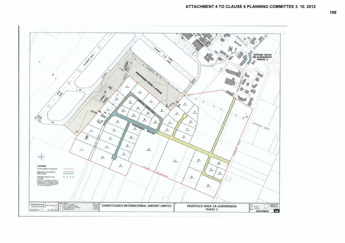
ATTACHMENT 4 TO CLAUSE 6 PLANNING COMMITTEE 3. 10. 2012199
ATTACHMENT 5 TO CLAUSE 6 PLANNING COMMITTEE 3. 10. 2012200

ATTACHMENT 5 TO CLAUSE 6 PLANNING COMMITTEE 3. 10. 2012201
ATTACHMENT 5 TO CLAUSE 6 PLANNING COMMITTEE 3. 10. 2012202