Embed Size (px)
Citation preview

64 Rhythm of the Sea

65CHAPTER 6 TREASURES UNDER THE SEA (AND ALONG THE COAST, TOO)
Chapter 6TREASURES UNDER
THE SEA (AND ALONGTHE COAST, TOO)
(Coastal Habitats and Resources)
an Vicente is rich in fish and other marine resources. At the start of the
nationwide implementation of the CRMP in May 1996, 35 researchers
from Silliman University conducted a survey in San Vicente.
The research team assessed the town’s coastal zones,
gathering data on vegetation, marine life, composition of
the sea bottom, water quality and currents, plankton, fish catch, and the
socioeconomic conditions of fishers.
The team established 108 sampling stations (Figure 6.1) for thefollowing:
l 19 for mangroves
l 12 shallow transect stations
l 8 for corals
l 10 for soft-bottom
l 8 for plankton
l 4 for coliform
S
l 7 for water current
l 8 for fish visual census
l 14 for test-fishing
l 9 for fisheries profile
l 9 for socioeconomic indicators
San Vicente
is rich in fish
and other
marine resources.

66 Rhythm of the Sea
Figure 6.1. Sampling stations of the Silliman University study in San Vicente, 1996.
E m ergen cy P t
B ing a P t
B a y Is la n d s
P ag d an a n B a y
Reef Pt
Squat t
Pt
Im
uruan I
L am pin igan I
Is let h ead
C ro w n P tBu l l ock Pt
Imuru
an B
ay
W ed ge I
N ewC anip o
S to . N iño
A l im an gu han
N ew V il la fr ia
P o rt B a rton
C aru ray
C a ta la t I
C a c b o lo I
Cata
O ld S iteC a ru ra y
Kay
doros
Conical Pt
Bunuang inan
M
ayday B ay
Bay
bay
Daraga
Perfo rated Pt O y ster P t
P eak ed Pt
A m aling a t P t
End
eav o
r I
T ree Pt
V i l l api ñaRegat ta
P
t
M ori son IQ u een’sB ay
B ub on P t
R idd le P t
C a g n ipa I
A lb a g ue n I
D ean I
C aram atan P t
E x otic I
B l uff Pt
B addl e I
W i lson H ead
B old H ead B oayan IPri ce Pt
N iaporay I
B oroughton Pt
Pagdanan Pt
Petulant Pt
V i ll ageB ay
L um o IH al l Pt
M i lner H eadRationesl P t
C on e I
Shark Pt
Cooke’ s PtDafaga Pt
Square Pt
Jibboom Bay
L ong Pt
D arapi ton R
C a p sala y I
San I si droNew A gutayaPoblacion
B i nga
1 0 4 8 ’o
1 0 4 0 ’o
1 0 3 0 ’o
1 0 2 0 ’o
1 0 1 4 ’o
1 0 4 8 ’o
1 0 4 0 ’o
1 0 3 0 ’o
1 0 2 0 ’o
1 0 1 4 ’o
11 9o
11 9 10 ’o
11 9 20 ’o
11 9o
11 9 10 ’o
11 9 20 ’o
0 2 4 6 8 km
SA N V IC E N T EPA L AWA N
##
##
#
1
2
#
L E GE ND :
Coral s
Coli f or m
F i s h V i s ual Cens us
H ous ehold In ter v iew
S horelin e E num er at ion
T es t F i s h in g - B S
T es t F i s h in g - S GN
M angr ov e
P lank t on
S of t B ott om
S eagr as s /A lgae/ Inv er tebrates
- Beach S eine- S et Gi ll Net- trans ect number- general collect ion only
Note: B S S GN n =
#
#
##
n
#
1
#
#
#
#1 2
#
#
#
#
#
1
1
2
2
#
#
# #
#
#
#
#
1
1
2
2
#
#
1 *
*
*
2

67CHAPTER 6 TREASURES UNDER THE SEA (AND ALONG THE COAST, TOO)
The results of the research on coastal habitats and resources are summarized
below:
REEF FISH
A visual census found 160 species of finfish, squid and octopii in 29 families
in the coral reef areas of the municipality (Figure 6.2). Palata or
damselfishes, and wrasses, had the highest number of species. Most of
the fishes recorded were reef species; there were no pelagics, such as
tuna and mackerel (Table 6.1). Capsalay had the greatest number of species
and highest density of fish. Imuruan had the most target species sought by
fishers, the most large predatory species, and the highest average number
of individuals. In terms of fishing pressure, Baybay Daraga appeared to
have suffered most — the census noted the absence of large predators
there.
The abundance of reef species in seagrass beds underscores the importance
of seagrasses as breeding or nursery grounds for fish and the need for this ecosystem
to be protected. Test fishing with a beach seine in seagrass and algal beds yielded 82
species of finfish in 36 families. Capsalay Island yielded the highest biomass of fish,
Figure 6.2. Catch composition by fish families in San Vicente (SUML 1996).
A visual census
found 160 species
of finfish in
29 families in the
coral reef areas
of the municipality.
S nappers(Lut janidae)
1 2 .0 %
J acks(Carangidae)
1 2 .0 %
S quid(Lol iginidae)
6 .5 %
Octopii(Octopididae)
3 .8 %
M onocle B reams(Nemipter idae)
1 2 .1 %E mperor B reams
(Lethr inidae)4 .0 %
Tuna and M ackerel(S combr idae)
1 2 .2 %
Groupers(S er ranidae)
1 5 .0 %
F us i l iers(Caes ionidae)
3 .3 %
Other s (2 6 fam)1 7 .0 %
Ponyf is hes(Leiognathidae)
2 .1 %

68 Rhythm of the Sea
and Poblacion recorded the lowest. The highest species richness was noted in Queen’s
Bay, the lowest in Catalat. Capsalay showed the best catch per unit effort, yielding 18
kg per man-hour (high by Philippine standards).
A comparison of sizes with previous data indicates that most species have
maintained their growth, which in turn suggests that San Vicente has not been overfished
unlike other areas in the country where most fishes barely reach their common reported
lengths. Nevertheless, the Silliman University team noted that “the tendency toward
exploitation is great and overharvesting may occur if fishing is not regulated.”
COMMERCIAL FISHING POTENTIAL
Table 6.1. Most abundant families of fishes in San Vicente (SUML 1996).
Pomacentridae (Damsels)
Labridae (Wrasses)
Scaridae (Parrotfishes)
Chaetodontidae (Butterflyfishes)
PomacentridaeLabridaeChaetodontidae
LabridaePomacentridaeChaetodontidae
PomacentridaeLabridaeChaetodontidaeSerranidae (Groupers)
PomacentridaeLabridaeChaetodontidae
PomacentridaeLabridaeChaetodontidae
PomacentridaeLabridaeApogonidae (Cardinalfishes)
Chaetodontidae
LabridaePomacentridaeSerranidaeAcanthuridae (Surgeonfishes)
Chaetodontidae
STATIONRELATIVE ABUNDANCE (%)
Number of Individuals
Capari
Catalat
Baybay Daraga
Shark Point
Casuyan
Albaguen
Capsalay
Imuruan
PomacentridaeCaesionidae (Fusiliers)
Labridae
PomacentridaeSiganidae (Rabbitfishes)
Labridae
PomacentridaeLabridaeApogonidae
PomacentridaeApogonidaeSiganidae
PomacentridaeLabridaeSphyraenidae (Barracudas)
PomacentridaeLabridaeCentriscidae (Shrimpfishes)
PomacentridaeApogonidaeLabridae
PomacentridaeLabridaeAcanthuridae
27.522.57.57.5
30.722.69.7
30.825.011.5
34.020.87.67.6
37.529.28.3
33.925.48.5
34.421.96.36.3
30.018.36.76.76.7
Number of Species
53.524.08.7
78.912.05.9
49.823.617.1
67.715.67.2
88.28.51.1
90.04.63.3
82.810.02.2
77.019.00.9

69CHAPTER 6 TREASURES UNDER THE SEA (AND ALONG THE COAST, TOO)
To determine the level of abundance of marine species, the researchers conducted
test fishing using 3 gill nets measuring 75 meters x 2 meters each. The nets had
varying mesh sizes: 1.5 cm, 2.5 cm, and 5 cm. The researchers found that 75% of their
catch was composed of finfish (including one tiger shark), and that the majority of this
were reef species. The highest volume of catch was recorded in Albaguen, the lowest
in Caruray. In terms of biomass, the species "timbugan" (goatfish - Mullidae) yielded
the greatest number. The highest species diversity seen was for "palata" (damselfish -
Pomacentridae). The researchers also noted that dried squid was an important source
of income for fishers, especially on Imuruan Island where it was sold at P180 to P220/
kg.
Imuruan Island was noted to suffer the least from fishing pressure, yielding the
greatest number of species and individuals. The highest fishing pressure was noted in
Baybay Daraga, where no predatory species were found.
In the 1996 annual report of San Vicente, the SEP-SVP reported that its coastal
marine project protected and managed the following habitats:
l mangroves - 1,538 hectares
l fish sanctuaries - 42.77 hectares in Binga, 45 hectares in Poblacion,
123 hectares in Port Barton, 25 hectares in Caruray
l artificial reefs - 20 hectares in Binga, Port Barton and Caruray
l seagrass - 130 hectares
CORALS
Researchers identified 163 species of corals in 14 families and reported that almost all
eight sampling stations had “good coral cover” (Table 6.2). The size of coral reef areas
ranged from 6 hectares at Shark’s Point to 150 hectares at Capsalay Island. Overall
cover of live hard coral was placed at 52%, with the Boayan Island station recording the
highest total coral cover (71%). The greatest number of species was found in Albaguen,
which had 88 different kinds of corals. Unfortunately, in August 1998, a coral bleaching
event, which raised water temperature to 340C, has killed a sizeable portion of living
corals in San Vicente (Box 6.1, Table 6.3).

70 Rhythm of the Sea
SEAGRASS
Eight seagrass species in 6 genera were recorded, occupying an estimated area of
225 hectares (Table 6.4). Capsalay Island in Port Barton had the most diverse collection
of seagrass, but the highest seagrass cover was recorded in Poblacion proper and
Queen’s Bay.
ALGAE
Surveys of the islands of Catalat and Boayan, as well as the shores of Gawid, yielded
96 species of algae in 55 genera. Sargassum was the most abundant species (Table
Table 6.2. Characteristics of coral reefs in San Vicente (SUML 1996).
STATIONSCORALREEFAREA
REEF FLATEXTENT(WIDTH)
SLOPE SUBSTRATE REMARKS
Boayan Island
Albaguen Island
Manta Ray Reef,Capsalay Island
Imuruan Island
Capari, Poblacion
Catalat Island
Shark Point,Port Barton
Baybay Daraga,Port Barton
Boayan Island
85 ha
150 ha
100 ha
6 ha
50 ha
100 m from theshoreline to thereef crest
-
200 m from theshoreline to thereef crest
300-m wide reefflat connectingthe shores ofImuruan andLampinigan Is.150 m from theshoreline
150 m from theshoreline, coralreef width is30 m from theSargassum bedat 5 m deep75-100 m fromthe rock outcrop
200 m from theshoreline
60o - 70o at 10m deep
-
40o - 45o at 10m deep
10o
15o - 20o at 10m deep
30o
30o
15o - 30o
sand, rubble, rock
sand, rubble, rock
sand, rubble, rock
sand, rubble, rock
sand, rubble, silt,rock
mostly rock; sand,rubble
mostly rock; sand,rubble
sand, rubble, silt,rock
good coral cover
wide patches of coralssurrounded by sandy area;good coral covergood coral cover; branchingand tabulate Acropora weredominant; Pocilloporadamicornis and branchingMontipora digitata common inthe shallow area and folioseMontipora in the deepsoft corals (Sarcophyton),tabulate Acropora and massivePorites were common
beyond 8 m deep, area is silty/sandy with sparse patches ofcorals; high cover of live andfragmented branching Acroporain the shallow stationboulders with coral recruitsfound within 5-12 m deep;beyond 12 m deep, substrateprimarily sandy; Sargassumbed in shallow area
soft corals abundant
beyond 10 m deep, areasandy/silty with patches ofcorals; numerous coral recruits

71CHAPTER 6 TREASURES UNDER THE SEA (AND ALONG THE COAST, TOO)
Box 6.1. Results of a coral reef survey in Port Barton.
In September 1998, several researchers from the PCSD and CRMP surveyed four reef sites in Port Barton. Thesurvey coincided with a warm water bleaching event which was occurring all over the southern Philippines at thetime.
Benthic results. Live hard coral cover ranged from 15% to 33.8%. This low figure can in part be explainedby the large proportion of bleached coral that was recorded in the “other” category. There was large-scale degradationat all sites resulting from anchor damage, and the past use of destructive fishing, such as blast or cyanide fishing.The best site in terms of live hard coral cover was Site 1 (Manta Ray Reef); by far the worst was Site 3 (AlbaguenIsland), which had only 15% coral cover and this was heavily degraded. Albaguen Sanctuary also revealed thesecond highest incidence of dead coral, the highest being at Paraiso Reef. Excessive bleaching was a majorconcern – this was recorded at all sites to a high degree. All sites can be classed in the “poor to fair” category forlive hard coral cover.
Fish indicator species. Fish indicator species were used to assess the level of overfishing and thetargeting of certain species, such as grouper, humphead wrasse, bumphead parrotfish and Barramundi cod. Notarget species was recorded indicating high exploitation levels. Butterflyfish are commonly used as an indicatorspecies of reef health. At all sites, only butterflyfish were recorded along the transect for indicator species assessment.Sites 2 and 4 had the highest number of butterflyfish, which corresponds with the sites’ high live coral cover. Noother indicator species except butterflyfish were recorded for the whole transect.
Descriptions of the four sites and the results follow.Site 1. Manta Ray ReefHigh temperatures (34oC) were recorded at 3m and 10m, even higher than at surface (31oC). Visibility was 8-10m.This reef is sheltered but it is unknown whether there have been storms that caused coral damage in recent years.Anthropogenic impacts were assessed as “moderate.”
Benthic results. Despite massive bleaching at the whole site, Manta Ray Reef appeared to have thehighest percentage of live hard coral along transect. Most bleaching was in shallow areas. Dead coral accountedfor 23.13%.
Site 2. Paraiso Reef also known as Heinz ReefWater was very warm. This is an exposed patch reef, close to Albaguen Island, of around 40m across and covering12 hectares. There was evidence of past destructive fishing (blast and possibly muro ami and cyanide).
Benthic results. Live coral cover was recorded at 30.6%. The incidence of bleaching was recorded at19.3%. Dead coral cover accounted for 31.9%.
Site 3. Albaguen Island near settlementThis is a fringing reef less than 100m from shore. This site is heavily degraded, with large amounts of Sargassumon the back reef. Silt was recorded settling on corals and some bleaching of anemones was noted.
Benthic results. This site had the lowest recorded live coral cover at only 15%. High growth of Sargassumand Padina was noted at 24.38% and 8.13%, respectively. Dead coral accounted for 13.8% but rubble (largely fromblast fishing) was high at 13.1%.
Site 4. Albaguen Island proposed SanctuaryThis fringing reef lies 90m from shore with a steep drop-off at 60o to 30m. Coral was noted on the upper 10m only.Damage (blast scars, rubble and anchor damage) appeared quite old. Two spear fishers were sighted duringsurvey. The reef has many fish, and the fish are relatively large (the area appears to have the highest diversityamong the sites surveyed). Good site for a sanctuary.
Benthic results. This area had the second highest coral cover (33.1%) and the highest incidence of coralbleaching (25%). It also had the second highest cover of dead hard coral (27.5%).
Source: Curran and Comer 1998

72 Rhythm of the Sea
* all soft corals were bleached and recorded in the bleached category
Table 6.3. Summary of benthic assessments (percentage of frequency cover) of four sites inPort Barton (Curran and Comer 1998).
Table 6.4. Extent of seagrass and algae in San Vicente (SUML 1996).
BENTHIC CATEGORYMANTA RAY
REEFSITE 1
PARAISOREEFSITE 2
ALBAGUEN(NEAR SETTLEMENT)
SITE 3
ALBAGUEN(PROPER & SANCTUARY)
SITE 4
Hard coralSoft coral*Dead coralFleshy seaweedSpongeRockRubbleSandSilt/clayOthersCoral bleachingBlack band disease
33.7-
23.5-
1.03.7
12.513.7
-2.57.51.9
30.8-
31.9-
0.64.47.52.5
-1.0
19.41.9
15.1-
13.724.4
5.06.9
13.18.1
-8.15.6
-
33.2-
27.50.60.66.95.0
--
0.625.0
0.6
SITE VEGETATION EXTENT
Primary Data
Boayan Island
Albaguen Island
Exotic IslandPoblacion ProperImuruan IslandCapariCatalat Island and vicinityGawidQueen's BayCapsalay
seagrassfoliose algaeSargassumfoliose algaeSargassumseagrasscoralline articulated algaeSargassumSargassumSargassumseagrassfoliose algae and Sargassumseagrass
Secondary Data (Interview)
BingaPort BartonCarurayPoblacionNew Villafria
seagrassseagrassseagrassseagrassseagrass
50 hectares70 hectares50 hectares45 hectares10 hectares
0.0.
50.0.0.
100.5.0.5.5.2.1.0.
hectarehectaresquare metershectarehectarehectaressquare metershectarehectareshectareshectareshectarehectare
2304
4225
695410035
73CHAPTER 6 TREASURES UNDER THE SEA (AND ALONG THE COAST, TOO)
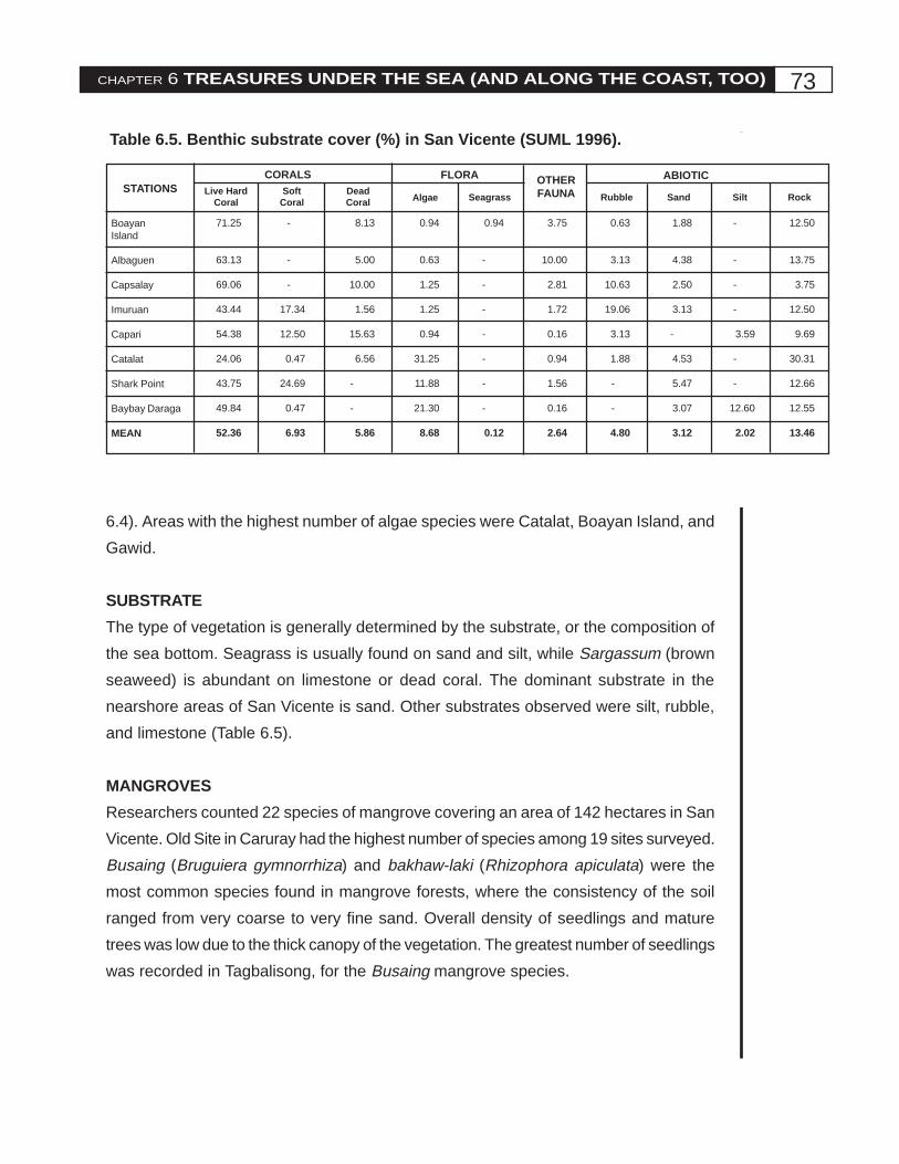
6.4). Areas with the highest number of algae species were Catalat, Boayan Island, and
Gawid.
SUBSTRATE
The type of vegetation is generally determined by the substrate, or the composition of
the sea bottom. Seagrass is usually found on sand and silt, while Sargassum (brown
seaweed) is abundant on limestone or dead coral. The dominant substrate in the
nearshore areas of San Vicente is sand. Other substrates observed were silt, rubble,
and limestone (Table 6.5).
MANGROVES
Researchers counted 22 species of mangrove covering an area of 142 hectares in San
Vicente. Old Site in Caruray had the highest number of species among 19 sites surveyed.
Busaing (Bruguiera gymnorrhiza) and bakhaw-laki (Rhizophora apiculata) were the
most common species found in mangrove forests, where the consistency of the soil
ranged from very coarse to very fine sand. Overall density of seedlings and mature
trees was low due to the thick canopy of the vegetation. The greatest number of seedlings
was recorded in Tagbalisong, for the Busaing mangrove species.
Table 6.5. Benthic substrate cover (%) in San Vicente (SUML 1996).
STATIONSCORALS
Live HardCoral
SoftCoral
DeadCoral
FLORA
Algae Seagrass
OTHERFAUNA
ABIOTIC
Rubble Sand Silt Rock
BoayanIsland
Albaguen
Capsalay
Imuruan
Capari
Catalat
Shark Point
Baybay Daraga
MEAN
71.25
63.13
69.06
43.44
54.38
24.06
43.75
49.84
52.36
-
-
-
17.34
12.50
0.47
24.69
0.47
6.93
8.13
5.00
10.00
1.56
15.63
6.56
-
-
5.86
0.94
0.63
1.25
1.25
0.94
31.25
11.88
21.30
8.68
0.94
-
-
-
-
-
-
-
0.12
3.75
10.00
2.81
1.72
0.16
0.94
1.56
0.16
2.64
0.63
3.13
10.63
19.06
3.13
1.88
-
-
4.80
1.88
4.38
2.50
3.13
-
4.53
5.47
3.07
3.12
-
-
-
-
3.59
-
-
12.60
2.02
12.50
13.75
3.75
12.50
9.69
30.31
12.66
12.55
13.46

74 Rhythm of the Sea
PLANKTON
Seventy-one percent of the plankton community sampled were diatoms, with 69 genera
recorded (Figure 6.3). The dinoflagellate group was composed of 55 species in 20
genera. There were also 37 groups of zooplankton recorded. Shrimp larvae were
common. High densities of fish larvae and eggs were recorded in Catalat and Poblacion.
PCRA RESULTS
Splashes of red on most of the barangay maps produced in the PCRA show that coral
reefs abound in the waters of San Vicente. Seagrass and mangroves are also found in
many of the villages. During the habitat assessment sessions of the PCRA, the fishers
were asked to evaluate and rate four habitats: beaches, seagrass, mangroves, and
coral reefs. Later, volunteers accompanied the PCRA team in validating their assessment
of coral reefs through snorkel surveys in 29 sites.
A summary of the fishers' evaluation is contained in Table 6.7. In the first six
sites, the assessment of habitats was not systematically done. This explains why some
entries say "not assessed." In the last site, the extensive coral reefs were too far away
to be surveyed. The table also shows the findings of the snorkel survey of the coral
reefs (last column).
Details of the PCRA habitat assessment for coral reefs, showing the percentages
of various components of the substrate as well as the coral cover, are shown in Table
6.8.
During the resource mapping session of the PCRA, local fishers identified the
Figure 6.3. Plankton distribution in San Vicente (SUML 1996).
D ia tom70%
O ther A lgae6%
D ino flage llates5%
Zoop lankton19%
75CHAPTER 6 TREASURES UNDER THE SEA (AND ALONG THE COAST, TOO)
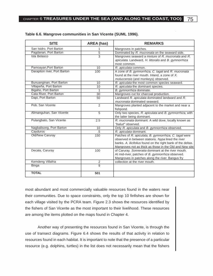
Table 6.6. Mangrove communities in San Vicente (SUML 1996).
most abundant and most commercially valuable resources found in the waters near
their communities. Due to space constraints, only the top 10 finfishes are shown for
each village visited by the PCRA team. Figure 2.3 shows the resources identified by
the fishers of San Vicente as the most important to their livelihood. These resources
are among the items plotted on the maps found in Chapter 4.
Another way of presenting the resources found in San Vicente, is through the
use of transect diagrams. Figure 6.4 shows the results of that activity in relation to
resources found in each habitat. It is important to note that the presence of a particular
resource (e.g. dolphins, turtles) in the list does not necessarily mean that the fishers
SITE AREA (has) REMARKS153
10100
1010
13050
2
5
2.5
10.5
150
100
29
501
Mangroves in patches.Dominated by R. mucronata on the seaward side.Mangroves seaward a mixture of R. mucronata and R.apiculata. Landward, H. littoralis and B. gymnorrhizamost common.R. apiculata common.A zone of B. gymnorrhiza, C. tagal and R. mucronatafound at the river mouth. Inland, a zone of X.moluccensis (and monkeys) observed.R. apiculata the most common species seaward.R. apiculata the dominant species.B. gymnorrhiza dominate.Mangroves cut for charcoal production.Landward R. apiculata dominated landward and R.mucronata dominated seaward.Mangroves planted adjacent to the market and near afishpond.Only two species, R. apiculata and B. gymnorrhiza, withthe latter being dominant.R. mucronata dominant. A wild dove, locally known as"balud" observed.Only R. apiculata and B. gymnorrhiza observed.R. apiculata dominant.Patches of R. apiculata, B. gymnorrhiza, C. tagal wereobserved in between stations. Nypa lined the riverbanks. A. ilicifolius found on the right bank of the deltas.Mangroves not as thick as those in the Old and New siteof Caruray. Sonneratia dominant at the river mouth.At mid-river, patches of B. gymnorrhiza observed.Mangroves in patches along the river. Bangus frycollection at the river mouth.
San Isidro, Port BartonPagdanan, Port BartonIsla Belasco
Pamoayan,Port BartonDarapiton river, Port Barton
Bunuanginan, Port BartonVillapeña, Port BartonBigaho, Port BartonCata River, Port BartonDapi, Port Barton
Pob. San Vicente
Alimanguhan, San Vicente
Pulangbato, San Vicente
Nagbalisong, Port BartonCaydurosOld/New Caruray
Decala, Caruray
Kemdeng VillafriaBinga
TOTAL

76 Rhythm of the Sea
catch these animals. The basic criteria for this list are the abundance of certain resources
in the locality and the commercial importance of these resources to fishers. The list is
not exhaustive, but it is a good reflection of the fishers’ perception of their marine
environment. The transect diagram is a helpful tool in managing resources according
to habitat. By studying this diagram, coastal managers can easily determine which
places are overfished and thus focus their efforts on controlling the exploitation of
resources in these ecosystems.

77CHAPTER 6 TREASURES UNDER THE SEA (AND ALONG THE COAST, TOO)
Table 6.7. Results of the habitat assessment in San Vicente, PCRA 1997.
NA - not assessed
Pinagmalucan good NA - NA 26.8
Panindigan good NA - NA 36.3
Macatumbalen good good good NA 33.6
Daplak fair fair - NA 33.0
Casoyan good good NA NA 27.0
Pulang Bato NA NA NA NA 42.3
Catalat fair fair - fair 25.8
Sta. Cruz fair good good fair 31.5
Gawid good good good good 33.0
Decala poor - good - -
Old Caruray fair fair good good 67.3
Barongbong good good - good 68.0
Albaguen good good - good 55.0
Pagdanan fair fair good good 54.0
(Queen's Bay)
Capsalay good good good good 53.0
Port Barton
(Poblacion) excellentgood good good 62.5
Pamoayan fair fair good fair 27.5
Naonao/Bigaho fair fair good fair 44.3
Baybay Daraga good good - fair 32.3
New Villafria fair fair fair fair 36.0
(due to mining)
New Agutaya excellent- good good 59.6
San Isidro excellent- - fair 34.4
Sto. Niño excellent- - fair 42.0
New Canipo good - good good 28.0
Imuruan good - - good 31.5
Binga/Buding good excellentgood good 33.0
Wedge Island - - - fair 44.5
Cauban good - good fair 78.0
Alimanguan excellent- good low NA
SITE BEACHES SEAGRASS MANGROVE CORAL REEF MEAN PERCENTTOTAL COVER (%)LIVE CORAL

78 Rhythm of the Sea
Table 6.8. Assessment of coral reefs in San Vicente, PCRA 1997.
NA - not assessed
BARANGAY/SITIO NUMBER OFOBSERVERS
TOTAL DEADSUBSTRATE
SOFTCORAL
PoblacionPinagmalucanPanindiganPoblacionDaplacCasoyanPulang Bato
CarurayCatalat IslandSta. CruzGawidOld Caruray
Port BartonBarongbongAlbaguen IslandQueen's BayCapsalay IslandPort Barton ProperPamuayanNaonao/BigahoBaybay Daraga
New Villafria
New Agutaya
San Isidro
Sto. Niño
New Canipo
BingaImuruan IslandBinga ProperWedge IslandCauban
Alimanguhan
435323
322
33222233
3
3
3
1
1
2121
NA
73.263.766.467.073.057.7
84.268.567.032.7
31.945.045.047.037.572.555.667.6
64.0
40.4
65.6
58.0
72.0
68.567.055.522.0
23.336.333.632.024.023.5
14.026.524.315.6
27.351.031.551.535.522.033.730.3
17.7
24.3
8.7
6.0
4.0
22.015.021.022.0
3.50.00.01.03.0
18.8
1.85.09.0
51.7
40.74.0
23.51.5
27.05.5
10.62.0
18.3
35.3
25.7
36.0
24.0
9.518.023.556.0
HARDCORAL

79C
HA
PT
ER 6
TR
EA
SU
RE
S U
ND
ER
TH
E S
EA
(AN
D A
LO
NG
TH
E C
OA
ST, T
OO
)Figure 6.4. Transect diagram of coastal resources* in San Vicente classified according to habitat, PCRA 1997.
SITE BEACH INSHOREFLAT
LAGOON/BAY
OFFSHORECORAL REEF
ISLAND/MANGROVE
DEEPOCEAN
Pinagmalucan
Panindigan
Macatumbalen
Daplac
Kasuyan
liswi, sikad-sikad,halaan, tagitis,kanaway
tagitis, pebbles
bagasay, tagitis,punaw
bogitis, balingsara,agokoy, sihi
tagitis, bagasay
shells, seaweeds,balatan, alimasag,pugita, isdang-bato
shell, danggit,alimasag
budyong,alimasag, pugita,alimango, isda,suso, hipon, tipay,liswi, tarab, lato,balatan, banagan,seahorseliswi, kasag, sa-ang, sihi, samong,taklobo, lato,guso, isdanggagmay, sikad-sikadsihi, kasag, lato,lapas, balatan
bangus fry,alamang, sugpo,alimasag, balatan,dilis, pusit bahura,pagi, sapsapmulmol, danggit,katambak, liswi,taklobo, pugita
kanuping, danggit,haus-haus, palata,palad, mulmol,pagi, pating
taklobo,matambaka, burao,pugita, tauban,banagan, alimasag,mamsa
taklobo, liswi, saliot,mulmol, danggit,lato, banak
tauban, pugita,maya-maya,danggit, lapu-lapu, taklobo,sananglapu-lapu,kanuping, mulmol,pusit bahura,taklobo, pugita,kolambutan,banaganpusit, kanuping,talakitok,kalapato, danggit,pagi, pating,alimasag,banagan, sapsap
pawikan, suno,pagi, lapu-lapu,mulmol, kanuping,tangigue, danggit
lapu-lapu, lawian,dalagang-bukid,pugita, samong,suwahan
___
Island:sandy beach
Mangrove:alimango, talaba,tamilok
___
Isla Manok:samong, sihi, sisi,payong-payong,tanakogon
pusit laot, burao,kalapato, besugo,salayginto, tulingan,salmollete
torsillo, pusit laot,tangigue, maya-maya, kalapato,alumahan, tabagak,dilis
bisugo, sapsap,tulingan, tangigue,kalaso, maya-maya, tursilyo,pating
tauban, pusitkalapato, lumba-lumba, galung-gong, sulid, maya-maya, rompi pating,lapu-lapumamsa, tangiguemaya-maya, sagisi,suso, dalagang-bukid, anay-anay,kalapato,galunggong
BARANGAY POBLACION

80R
hyth
m o
f the S
ea
BARANGAY CARURAY
SITE BEACH INSHOREFLAT
LAGOON/BAY
OFFSHORECORAL REEF
Catalat
Sta. Cruz
Gawid
Decala
Old Site Caruray
bogitis, sihi, lapas
silica sand, itlog ngpawikan, shells
saroksarok, lapas,sisi
alimango, hipon,alimasag
punaw, kaykay
sa-ang, liswi, lato,kasag
alimasag, pugita,laot, sihi, sa-ang,liswi, bulatok,bangus fry
taktakon, sa-ang,alimasag, liswi,kapinan
kibaw, punaw,talaba, tamilok
sihi, balatan, lato,sa-ang, alimasag,samong
pugita, pusit,banagan, lapu-lapu, kanuping,tauban, pawikan,mulmolsapsap, bisugo,burao, pusit,tamban, kalapato,talakitok, hasa-hasa, pugita,lambaypugita, kanuping,danggit, sulid,bisugo, mulmol
bisugo, banak,pusit, sapsap,espada, tamban,lapu-lapudanggit, banak,liwit, mulmol,karaho, basa,banagan, taklobo
maya-maya,sagisi, sulid,dalagang-bukid,olpot, kalamuhoy
danggit, kanuping,banagan, lapu-lapu, mulmol,pusit bahura,pugitapugita, tauban,isdang bato,balatan, banagan
_____
lapu-lapu,kanuping, tauban,pagi, mulmol,pakol, pusit,pawikan, taklobo,pating
ISLAND/MANGROVE
DEEPOCEAN
(Catalat is anisland)
___
Isla Garcia:danggit, sulid,pugita, tauban
___
Isla Garcia: sihi,pusit, lumban,banagan, pugita,banak, mulmol,danggitMangrove:uway, nipaalimango,tamilok, pagihipon
lapu-lapu, sagisi,banagan, pating,lipti
tangigue, tulingan,mamsa
maya-maya, sagisi,ulpot, kalamuhoy,maya-maya, suno,mamsa, talakitok,lapu-lapu, suno,maya-maya
sagisi, lapu-lapu,pakol, pusit,samong, kalapato,tangigue

81C
HA
PT
ER 6
TR
EA
SU
RE
S U
ND
ER
TH
E S
EA
(AN
D A
LO
NG
TH
E C
OA
ST, T
OO
)
BARANGAY PORT BARTON
SITE BEACH INSHOREFLAT
LAGOON/BAY
OFFSHORECORAL REEF
ISLAND/MANGROVE
DEEPOCEAN
Barongbong
Albaguen
Pagdanan
Capsalay
Port Barton (Poblacion)
Pamoayan
tagitis, sihi, lapas,takurog, taktakin
liswi, dagatan nataklobo
___(Houses on stilts inwater)
___
balas, bato
pawikan (nestingarea), sihi,alimasag
lato, sisi, liswi,sa-ang
sihi, kuya, lapas,sa-ang, samong,tacurong,balingkahoy,lukob-lukob
lato, liswi
mulmol, lato,kanuping, lumban,tarab, seagrass
banak, dilis, liswi,hipon, samong,alimasag
danggit, banak,dilis, liswi, sa-ang
taklobo, kuya,suno, danggit,kanuping,dalagang-bukidbisugo, suno,kanuping, bangsi,alumahan,tulingan,galunggong
bisugo, dilis,sapsap, pawikan
liwit, hasa-hasa,balo, dalagang-bukid, dolphins
sapsap, liwit, pitik,dolphin,matambaka,tambakol, ibondagat
sapsap, bisugo,espada, pak-an,salmollete, tarab,dolphin
pusit bahura,tauban, banagan,suno, mulmol
maya-maya, lapu-lapu, dalagang-bukid, sagisi,kalapato,salimburao,tulingan, tangiguelapu-lapu, pusit,burao, danggit,maya-maya,taklobo, liswi,taubansapsap, liswi,mulmol, danggit,tauban, pusit,lapu-lapu, taklobo,pawikanbalo, pak-an,tarab, pusit,pugita, tipay,banagan, tauban,dalagang-bukid,samong, taklobokanuping, bakoko,pusit, tauban
___
(Albaguen is anisland)
Velasco:lapu-lapu, burao,kalapato
(Capsalay is anisland)
Mangrove:ahas dagat,alimango
Mangrove:ahas dagat,alimango, hipon,kahoy
maya-maya, suno,olpot, tursilyo,mamsa, tangigue,tambakollapu-lapu, maya-maya, sagisi,dalagang-bukid
tangigue, tulingan,dolphin
pusit
Fishers rarely go todeep waters.
pusit

82R
hyth
m o
f the S
ea
BARANGAY NEW VILLAFRIA
SITE BEACH LAGOON/BAY
OFFSHORECORAL REEF
ISLAND/MANGROVE
DEEPOCEAN
New Villafria(barangay proper)
silica sand banak, liswi,talaba, tarab,alimasag, hipon
kanuping,dalagang bukid,hilo, ibon-dagat,talakitok,mangagat
lapu-lapu, lato,balo, danggit,pawikan, pugita,pusit, sihi, mulmol
Mangrove:alimango, nipa,kahoy
ahas dagat, pitik
Naonao & Bigaho
Baybay Daraga
silica sand
silica sand
banak, balatan,ahas dagat, liswi,sihi
talaba, liswi
bisugo, hipon, pak-an, tanguige,tulingan, alimasag,danggit,matambakatanguige, maya-maya, bisugo,dalagang-bukid,balo, danggit
pawikan, tauban,alimasag,banagan, pitik, sa-ang, taklobo, tarab,lapaspugita, pusit,tauban, taklobo,kanuping, pawikan
Mangrove:alimango, talaba
_____
tulingan, hasa-hasa
dolphin, tulingan
BARANGAY NEW AGUTAYA
SITE BEACH INSHOREFLAT
LAGOON/BAY
OFFSHORECORAL REEF
ISLAND/MANGROVE
DEEPOCEAN
New Agutaya(Bukana)
pawikan nestingsite, silica sand,talabong
dilis, lapad, aso-hos, bangus fry,alimasag
tulingan, burao,pusit, dolphins,ahas dagat
matambaka,galunggong, pitik,tauban
Mangrove:mangagat, bangusfry, lapu-lapu fry,hipon, kahoy,alimango
tauban

83C
HA
PT
ER 6
TR
EA
SU
RE
S U
ND
ER
TH
E S
EA
(AN
D A
LO
NG
TH
E C
OA
ST, T
OO
)
BARANGAY SAN ISIDRO
SITE BEACH INSHOREFLAT
LAGOON/BAY
OFFSHORECORAL REEF
ISLAND/MANGROVE
DEEPOCEAN
San Isidro(Bokbok)
pawikan nestingsite, bato, lawin,talaba
pusit burao, tanguige,turay (tambanfamily)
darag-darag,kanuping, lapu-lapu, tauban,pugita
Mangrove river:alimango, wildducks
salay-salay,bisugo, karaho,dolphin, pusit
BARANGAY STO. NIÑO
SITE BEACH INSHOREFLAT
LAGOON/BAY
OFFSHORECORAL REEF
ISLAND/MANGROVE
DEEPOCEAN
Sto. Niño(Mangingisda)
pawikan nestingsite, bangus fry,alimasag, sihi, nipa
_____ burao, pusit,bisugo, ibon dagat,sa-ang, talakitok,sapsap, asohos,espada, dolphin,sea snakes,dugong
danggit, lato,kanuping, pawikan,agahon (maya-maya family), sulid,tauban, pugita,alimango
_____ pusit, pitik
BARANGAY NEW CANIPO
SITE BEACH INSHOREFLAT
LAGOON/BAY
OFFSHORECORAL REEF
ISLAND/MANGROVE
DEEPOCEAN
New Canipo(barangay proper)
pawikan nestingsite, sihi, punaw,sea birds
dilis, banak, aso-hos, balo,alimasag, bangusfry
bisugo, pusit,sapsap, liswi,salayginto,dugong, dolphin
kanuping, burao,lato, pawikan,banagan, tauban,pugita
Mangrove:bangus fry, nipa
tauban, pitik, pusit

84R
hyth
m o
f the S
ea
* See List of Terms in the beginning section for the English names of these resources.
BARANGAY ALIMANGUAN
SITE BEACH INSHOREFLAT
LAGOON/BAY
OFFSHORECORAL REEF
ISLAND/MANGROVE
DEEPOCEAN
Alimanguan(Purok I)
pawikan nestingsite, silica sand
sapsap, dilis,samong, liswi,alimasag, bangusfry
bisugo, pusit,tanguige, balatan,pawikan, pitik,birds, taklobo,pagi, burao,tulingan, dolphin
pugita, banagan,kalapato,kanuping,agahon, talakitok,sea snakes,tauban
whale (month ofNovember)
BARANGAY BINGA
SITE BEACH INSHOREFLAT
LAGOON/BAY
OFFSHORECORAL REEF
ISLAND/MANGROVE
DEEP
Imuruan
Binga(barangay proper &Boding)
Cauban
pawikan nestingsite, liswi, sihi,lumban
pawikan nestingsite, sihi, lapas,punaw, sandpebbles, sea birds
pawikan nestingsite, sihi, lapas
___
lato, sapsap
dilis, pagi, pugita,samong (duringhabagat)
bisugo, talakitok,pusit, pagi,kalapato, sapsap,liswi, matambaka,kanupingbisugo, dilis, maya-maya, dolphin(Feb-May), burao,pusit, alimasag,pitik, talakitok,kanupingburao, pusit, maya-maya, kalapato,sapsap, liswi,bisugo, talakitok,tanguige
mulmol, danggit,tauban, banagan,pawikan, taklobo,sulid
lapu-lapu,danggit, pawikan,sea snakes, sulid,pusit, tauban,pugita, liswi,banagan, balatan,
danggit, pawikan,lumban
(Imuruan is anisland.)
Mangrove:nipa, alimango,bangus fry,bakhaw
Mangrove:bangus fry
Wedge lsland:danggit, taklobo,sea birds
galunggong,dolphin, whale,pusit, pitik, seasnakes
___(Fishers don’tusually go to deepwaters.)
dolphin, seasnakes, pusit, pitik