Embed Size (px)
Citation preview
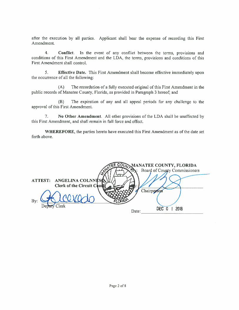
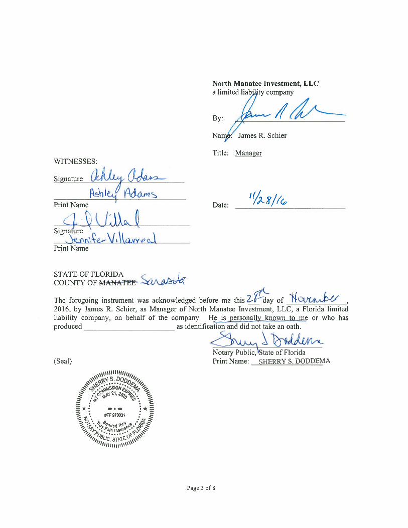
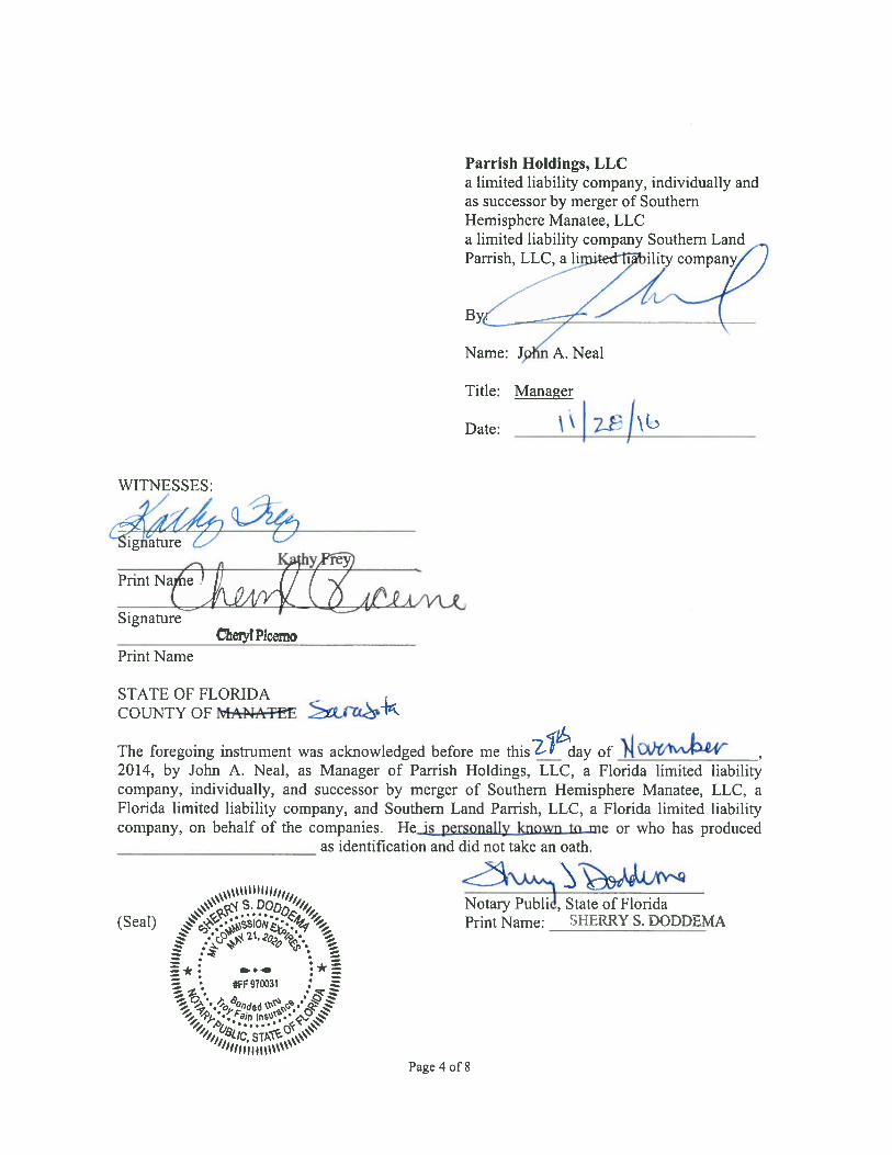
Page 5 of 8
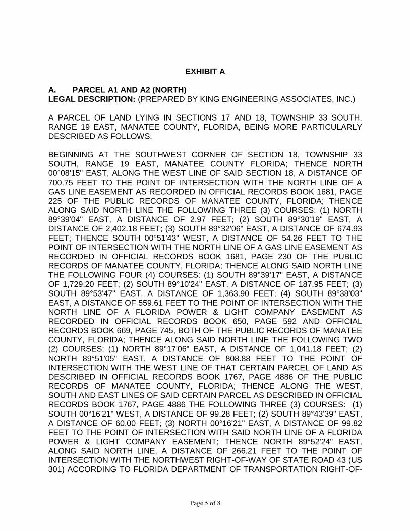
EXHIBIT A A. PARCEL A1 AND A2 (NORTH) LEGAL DESCRIPTION: (PREPARED BY KING ENGINEERING ASSOCIATES, INC.) A PARCEL OF LAND LYING IN SECTIONS 17 AND 18, TOWNSHIP 33 SOUTH, RANGE 19 EAST, MANATEE COUNTY, FLORIDA, BEING MORE PARTICULARLY DESCRIBED AS FOLLOWS: BEGINNING AT THE SOUTHWEST CORNER OF SECTION 18, TOWNSHIP 33 SOUTH, RANGE 19 EAST, MANATEE COUNTY FLORIDA; THENCE NORTH 00°08'15" EAST, ALONG THE WEST LINE OF SAID SECTION 18, A DISTANCE OF 700.75 FEET TO THE POINT OF INTERSECTION WITH THE NORTH LINE OF A GAS LINE EASEMENT AS RECORDED IN OFFICIAL RECORDS BOOK 1681, PAGE 225 OF THE PUBLIC RECORDS OF MANATEE COUNTY, FLORIDA; THENCE ALONG SAID NORTH LINE THE FOLLOWING THREE (3) COURSES: (1) NORTH 89°39'04" EAST, A DISTANCE OF 2.97 FEET; (2) SOUTH 89°30'19" EAST, A DISTANCE OF 2,402.18 FEET; (3) SOUTH 89°32'06" EAST, A DISTANCE OF 674.93 FEET; THENCE SOUTH 00°51'43" WEST, A DISTANCE OF 54.26 FEET TO THE POINT OF INTERSECTION WITH THE NORTH LINE OF A GAS LINE EASEMENT AS RECORDED IN OFFICIAL RECORDS BOOK 1681, PAGE 230 OF THE PUBLIC RECORDS OF MANATEE COUNTY, FLORIDA; THENCE ALONG SAID NORTH LINE THE FOLLOWING FOUR (4) COURSES: (1) SOUTH 89°39'17" EAST, A DISTANCE OF 1,729.20 FEET; (2) SOUTH 89°10'24" EAST, A DISTANCE OF 187.95 FEET; (3) SOUTH 89°53'47" EAST, A DISTANCE OF 1,363.90 FEET; (4) SOUTH 89°38'03" EAST, A DISTANCE OF 559.61 FEET TO THE POINT OF INTERSECTION WITH THE NORTH LINE OF A FLORIDA POWER & LIGHT COMPANY EASEMENT AS RECORDED IN OFFICIAL RECORDS BOOK 650, PAGE 592 AND OFFICIAL RECORDS BOOK 669, PAGE 745, BOTH OF THE PUBLIC RECORDS OF MANATEE COUNTY, FLORIDA; THENCE ALONG SAID NORTH LINE THE FOLLOWING TWO (2) COURSES: (1) NORTH 89°17'06" EAST, A DISTANCE OF 1,041.18 FEET; (2) NORTH 89°51'05" EAST, A DISTANCE OF 808.88 FEET TO THE POINT OF INTERSECTION WITH THE WEST LINE OF THAT CERTAIN PARCEL OF LAND AS DESCRIBED IN OFFICIAL RECORDS BOOK 1767, PAGE 4886 OF THE PUBLIC RECORDS OF MANATEE COUNTY, FLORIDA; THENCE ALONG THE WEST, SOUTH AND EAST LINES OF SAID CERTAIN PARCEL AS DESCRIBED IN OFFICIAL RECORDS BOOK 1767, PAGE 4886 THE FOLLOWING THREE (3) COURSES: (1) SOUTH 00°16'21" WEST, A DISTANCE OF 99.28 FEET; (2) SOUTH 89°43'39" EAST, A DISTANCE OF 60.00 FEET; (3) NORTH 00°16'21" EAST, A DISTANCE OF 99.82 FEET TO THE POINT OF INTERSECTION WITH SAID NORTH LINE OF A FLORIDA POWER & LIGHT COMPANY EASEMENT; THENCE NORTH 89°52'24" EAST, ALONG SAID NORTH LINE, A DISTANCE OF 266.21 FEET TO THE POINT OF INTERSECTION WITH THE NORTHWEST RIGHT-OF-WAY OF STATE ROAD 43 (US 301) ACCORDING TO FLORIDA DEPARTMENT OF TRANSPORTATION RIGHT-OF-
Page 6 of 8
WAY MAP, SECTION 1302-203; THENCE ALONG SAID NORTHWEST RIGHT-OF-WAY OF STATE ROAD 43 (US 301) THE FOLLOWING TWO (2) COURSES: (1) SOUTH 36°06'04" WEST, A DISTANCE OF 472.47 FEET; (2) SOUTH 36°04'54" WEST, A DISTANCE OF 345.85 FEET TO THE POINT OF INTERSECTION WITH THE SOUTH LINE OF SECTION 17, TOWNSHIP 33 SOUTH, RANGE 19 EAST; THENCE ALONG SAID SOUTH LINE OF SECTION 17 THE FOLLOWING TWO (2) COURSES: (1) SOUTH 89°51'05" WEST, A DISTANCE OF 648.05 FEET TO THE SOUTH 1/4 CORNER OF SAID SECTION 17; (2) SOUTH 89°17'06" WEST, A DISTANCE OF 2,668.97 FEET TO THE SOUTHEAST CORNER OF SAID SECTION 18; THENCE NORTH 89°08'38" WEST, ALONG THE SOUTH LINE OF SAID SECTION 18, A DISTANCE OF 5,299.33 FEET TO THE POINT OF BEGINNING. CONTAINING 138.95 ACRES. B. PARCEL A1 AND A2 (SOUTH) LEGAL DESCRIPTION: (PREPARED BY KING ENGINEERING ASSOCIATES, INC.) A PARCEL OF LAND LYING IN SECTIONS 19 AND 20, TOWNSHIP 33 SOUTH, RANGE 19 EAST, MANATEE COUNTY, FLORIDA, BEING MORE PARTICULARLY DESCRIBED AS FOLLOWS: BEGINNING AT THE NORTHWEST CORNER OF SECTION 19, TOWNSHIP 33 SOUTH, RANGE 19 EAST, MANATEE COUNTY FLORIDA; THENCE SOUTH 89°08'38" EAST, ALONG THE NORTH LINE OF SAID SECTION 19, A DISTANCE OF 5,299.33 FEET TO THE NORTHEAST CORNER OF SAID SECTION 19; THENCE ALONG THE NORTH LINE OF SECTION 20, TOWNSHIP 33 SOUTH, RANGE 19 EAST THE FOLLOWING TWO (2) COURSES: (1) NORTH 89°17'06" EAST, A DISTANCE OF 2,668.97 FEET TO THE NORTH 1/4 CORNER OF SAID SECTION 20; (2) NORTH 89°51'05" EAST, A DISTANCE OF 648.05 FEET TO THE POINT OF INTERSECTION WITH THE NORTHWEST RIGHT-OF-WAY OF STATE ROAD 43 (US 301) ACCORDING TO FLORIDA DEPARTMENT OF TRANSPORTATION RIGHT-OF-WAY MAP, SECTION 1302-203; THENCE ALONG SAID NORTHWEST RIGHT-OF-WAY OF STATE ROAD 43 (US 301) THE FOLLOWING TWO (2) COURSES: (1) SOUTH 36°04'54" WEST, A DISTANCE OF 570.18 FEET TO THE POINT ON A NON-TANGENT CURVE TO THE LEFT; (2) SOUTHERLY 971.94 FEET ALONG THE ARC OF SAID CURVE, HAVING A RADIUS OF 1,977.86 FEET, A CENTRAL ANGLE OF 28°09'21", AND A CHORD BEARING AND DISTANCE OF SOUTH 22°01'42" WEST 962.19 FEET; THENCE NORTH 89°26'34" WEST, A DISTANCE OF 1,282.99 FEET; THENCE SOUTH 00°06'08" EAST, A DISTANCE OF 1,300.10 FEET TO THE POINT OF INTERSECTION WITH THE NORTH RIGHT-OF-WAY OF MOCCASIN WALLOW ROAD ACCORDING TO ROAD PLAT BOOK 4, PAGE 153 OF THE PUBLIC RECORDS OF MANATEE COUNTY, FLORIDA; THENCE ALONG SAID NORTH RIGHT-OF-WAY THE FOLLOWING FIVE (5) COURSES: (1) NORTH 88°54'18" WEST, A DISTANCE OF 1,334.91 FEET; (2) NORTH 89°08'58" WEST, A DISTANCE OF 2,271.84 FEET; (3) NORTH 89°07'49" WEST, A DISTANCE OF 328.34 FEET; (4)
Page 7 of 8
NORTH 89°07'50" WEST, A DISTANCE OF 2,693.55 FEET; (5) NORTH 88°01'42" WEST, A DISTANCE OF 16.92 FEET TO THE POINT OF INTERSECTION WITH THE WEST LINE OF SAID SECTION 19; THENCE NORTH 00°08'36" EAST, ALONG SAID WEST LINE OF SECTION 19, A DISTANCE OF 2,578.91 FEET TO THE POINT OF BEGINNING. CONTAINING 441.63 ACRES. C. PARCEL A3 AND A4 LEGAL DESCRIPTION: (PREPARED BY KING ENGINEERING ASSOCIATES, INC.) A PARCEL OF LAND LYING IN SECTIONS 16, 17 AND 18, TOWNSHIP 33 SOUTH, RANGE 19 EAST, MANATEE COUNTY, FLORIDA, BEING MORE PARTICULARLY DESCRIBED AS FOLLOWS: COMMENCING AT THE SOUTHWEST CORNER OF SECTION 18, TOWNSHIP 33 SOUTH, RANGE 19 EAST, MANATEE COUNTY FLORIDA; THENCE NORTH 00°08'15" EAST, ALONG THE WEST LINE OF SAID SECTION 18, A DISTANCE OF 700.75 FEET TO THE POINT OF INTERSECTION WITH THE NORTH LINE OF A GAS LINE EASEMENT AS RECORDED IN OFFICIAL RECORDS BOOK 1681, PAGE 225 OF THE PUBLIC RECORDS OF MANATEE COUNTY, FLORIDA, SAME BEING THE POINT OF BEGINNING; THENCE CONTINUE ALONG SAID WEST LINE, NORTH 00°08'15" EAST A DISTANCE OF 1,244.00 FEET; THENCE SOUTH 87°03'06" EAST, A DISTANCE OF 3,097.80 FEET; THENCE NORTH 00°49'44" EAST, A DISTANCE OF 470.00 FEET; THENCE SOUTH 89°49'04" EAST, A DISTANCE OF 2,293.32 FEET; THENCE NORTH 00°35'38" EAST, A DISTANCE OF 2,383.98 FEET; THENCE SOUTH 89°43'15" EAST, A DISTANCE OF 889.63 FEET; THENCE SOUTH 00°11'16" WEST, A DISTANCE OF 383.27 FEET; THENCE SOUTH 68°30'43" EAST, A DISTANCE OF 1,332.96 FEET; THENCE NORTH 27°47'24" EAST, A DISTANCE OF 1,049.93 FEET; THENCE SOUTH 89°59'54" EAST, A DISTANCE OF 4,022.59 FEET TO THE POINT OF INTERSECTION WITH THE NORTHWEST RIGHT-OF-WAY OF STATE ROAD 43 (US 301) ACCORDING TO FLORIDA DEPARTMENT OF TRANSPORTATION RIGHT-OF-WAY MAP, SECTION 1302-203; THENCE SOUTH 36°06'04" WEST, ALONG SAID NORTHWEST RIGHT-OF-WAY, A DISTANCE OF 4,285.76 FEET TO THE POINT OF INTERSECTION WITH A NORTHERLY LINE OF THAT CERTAIN PARCEL OF LAND AS DESCRIBED IN OFFICIAL RECORDS BOOK 2207, PAGE 6256 OF THE PUBLIC RECORDS OF MANATEE COUNTY, FLORIDA; THENCE ALONG NORTHERLY AND WESTERLY LINES OF SAID CERTAIN PARCEL OF LAND AS DESCRIBED IN OFFICIAL RECORDS BOOK 2207, PAGE 6256 THE FOLLOWING ELEVEN (11) COURSES: (1) NORTH 08°36'03" WEST, A DISTANCE OF 47.56 FEET; (2) NORTH 20°23'31" WEST, A DISTANCE OF 18.86 FEET; (3) NORTH 46°10'58" WEST, A DISTANCE OF 39.52 FEET; (4) NORTH 75°36'36" WEST, A DISTANCE OF 14.84 FEET; (5) NORTH 54°56'49" WEST, A DISTANCE OF 23.51 FEET; (6) SOUTH 88°03'46" WEST, A DISTANCE OF 11.96 FEET; (7) NORTH 82°06'14" WEST, A DISTANCE OF 29.71 FEET; (8) NORTH 69°38'08" WEST, A DISTANCE OF 48.16 FEET; (9) NORTH 73°32'48" WEST, A DISTANCE OF 65.00
Page 8 of 8
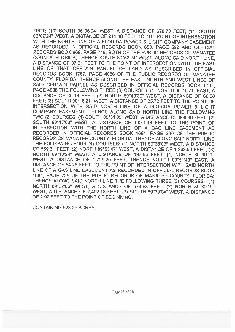
FEET; (10) SOUTH 36°06'04" WEST, A DISTANCE OF 670.70 FEET; (11) SOUTH 00°02'24" WEST, A DISTANCE OF 211.48 FEET TO THE POINT OF INTERSECTION WITH THE NORTH LINE OF A FLORIDA POWER & LIGHT COMPANY EASEMENT AS RECORDED IN OFFICIAL RECORDS BOOK 650, PAGE 592 AND OFFICIAL RECORDS BOOK 669, PAGE 745, BOTH OF THE PUBLIC RECORDS OF MANATEE COUNTY, FLORIDA; THENCE SOUTH 89°52'24" WEST, ALONG SAID NORTH LINE, A DISTANCE OF 87.31 FEET TO THE POINT OF INTERSECTION WITH THE EAST LINE OF THAT CERTAIN PARCEL OF LAND AS DESCRIBED IN OFFICIAL RECORDS BOOK 1767, PAGE 4886 OF THE PUBLIC RECORDS OF MANATEE COUNTY, FLORIDA; THENCE ALONG THE EAST, NORTH AND WEST LINES OF SAID CERTAIN PARCEL AS DESCRIBED IN OFFICIAL RECORDS BOOK 1767, PAGE 4886 THE FOLLOWING THREE (3) COURSES: (1) NORTH 00°16'21" EAST, A DISTANCE OF 35.18 FEET; (2) NORTH 89°43'39" WEST, A DISTANCE OF 60.00 FEET; (3) SOUTH 00°16'21" WEST, A DISTANCE OF 35.72 FEET TO THE POINT OF INTERSECTION WITH SAID NORTH LINE OF A FLORIDA POWER & LIGHT COMPANY EASEMENT; THENCE ALONG SAID NORTH LINE THE FOLLOWING TWO (2) COURSES: (1) SOUTH 89°51'05" WEST, A DISTANCE OF 808.88 FEET; (2) SOUTH 89°17'06" WEST, A DISTANCE OF 1,041.18 FEET TO THE POINT OF INTERSECTION WITH THE NORTH LINE OF A GAS LINE EASEMENT AS RECORDED IN OFFICIAL RECORDS BOOK 1681, PAGE 230 OF THE PUBLIC RECORDS OF MANATEE COUNTY, FLORIDA; THENCE ALONG SAID NORTH LINE THE FOLLOWING FOUR (4) COURSES: (1) NORTH 89°38'03" WEST, A DISTANCE OF 559.61 FEET; (2) NORTH 89°53'47" WEST, A DISTANCE OF 1,363.90 FEET; (3) NORTH 89°10'24" WEST, A DISTANCE OF 187.95 FEET; (4) NORTH 89°39'17" WEST, A DISTANCE OF 1,729.20 FEET; THENCE NORTH 00°51'43" EAST, A DISTANCE OF 54.26 FEET TO THE POINT OF INTERSECTION WITH SAID NORTH LINE OF A GAS LINE EASEMENT AS RECORDED IN OFFICIAL RECORDS BOOK 1681, PAGE 225 OF THE PUBLIC RECORDS OF MANATEE COUNTY, FLORIDA; THENCE ALONG SAID NORTH LINE THE FOLLOWING THREE (3) COURSES: (1) NORTH 89°32'06" WEST, A DISTANCE OF 674.93 FEET; (2) NORTH 89°30'19" WEST, A DISTANCE OF 2,402.18 FEET; (3) SOUTH 89°39'04" WEST, A DISTANCE OF 2.97 FEET TO THE POINT OF BEGINNING. CONTAINING 623.25 ACRES.

December 1, 2016 - Land Use Meeting Agenda Item #11
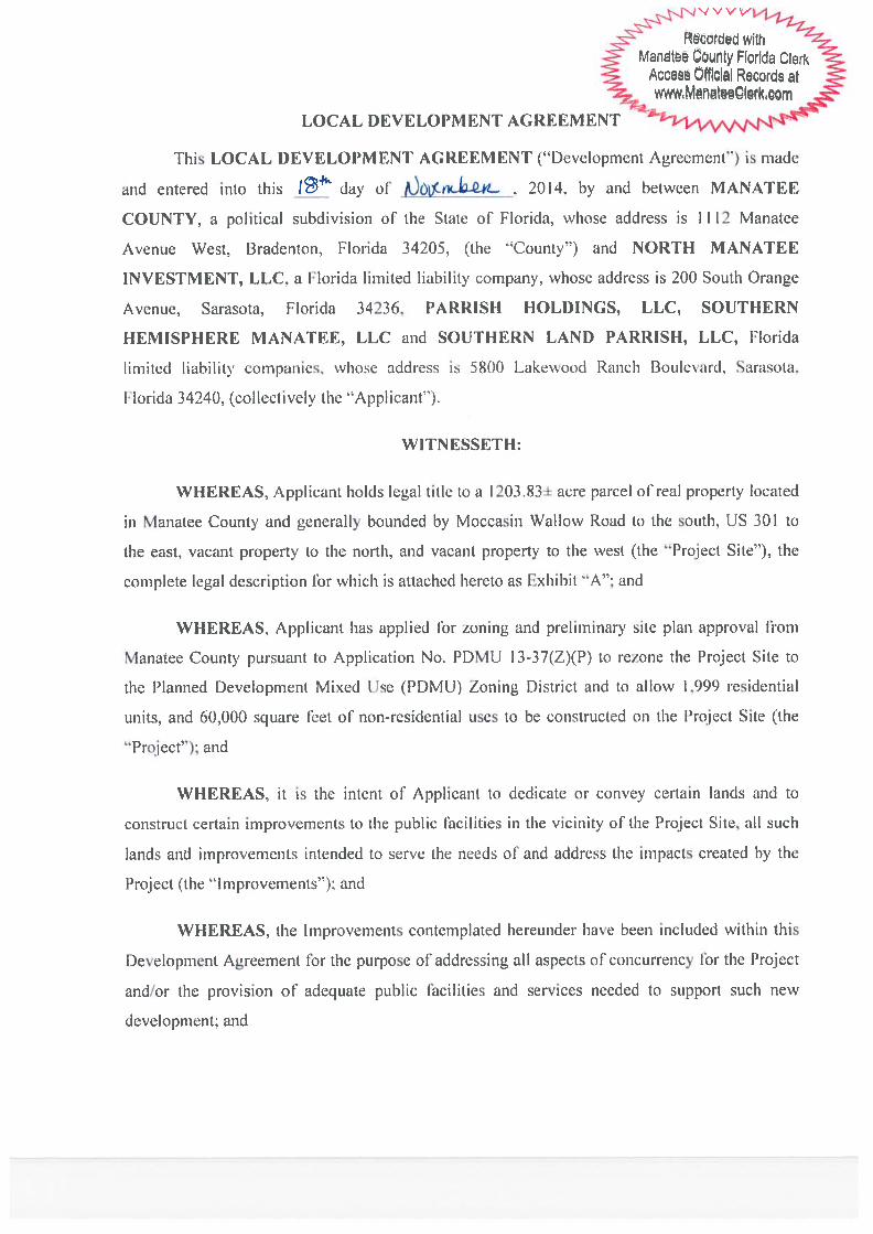
Subject LDA-13-02(R) - Parrish Holdings, LLC/Southern Land Parrish, LLC/Southern Hemisphere Manatee, LLC/North Manatee Investment, LLC/The Villages of Amazon South Local Development Agreement - DTS20160456 - Quasi-Judicial - Sia Mollanazar Briefings Briefing Provided Upon Request Contact and/or Presenter Information
Presenters:
Sia Mollanazar, Deputy Director - Engineering Services,
941-748-4501 ext. 7487
Clarke Davis, Transportation Planning Manager,
941-748-4501 ext. 7272
Contact:
Bobbi Roy, Planning Coordinator, 941-748-4501 ext. 6878
Action Requested
RECOMMENDED MOTION:
Based upon the evidence presented, comments made at the Public Hearing, and finding the request to be CONSISTENT with the Manatee County Comprehensive Plan and Manatee County Land Development Code, I move to APPROVE LDA-13-02(R) for The Village of Amazon South, as recommended by staff.
(Commissioner Whisenant Trace)
Enabling/Regulating Authority
Manatee County Comprehensive Plan
Manatee County Land Development Code
Section 163.3180(5), Florida Statutes
Manatee County Government Administrative BuildingFirst Floor, Chambers
December 1, 2016 - 9:00 AM
Sections 163.3220-163.3243, Florida Statutes
Background Discussion
● The request is for approval of an amendment to the existing Local Development Agreement for The Villages of Amazon Subdivision.
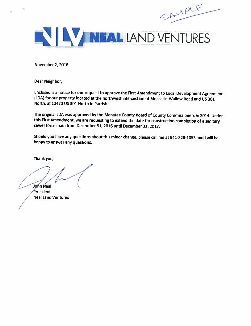
● The request is to amend the date for construction of a sanitary sewer force main from December 31, 2016 by one year, to December 31, 2017.
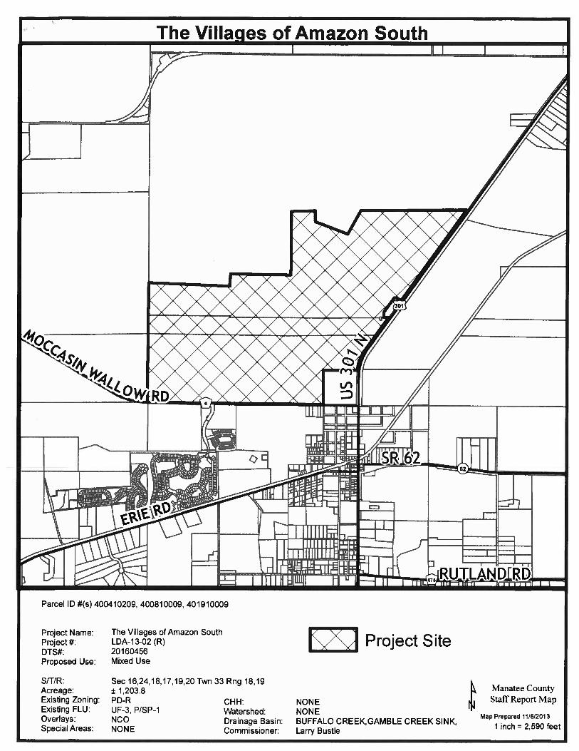
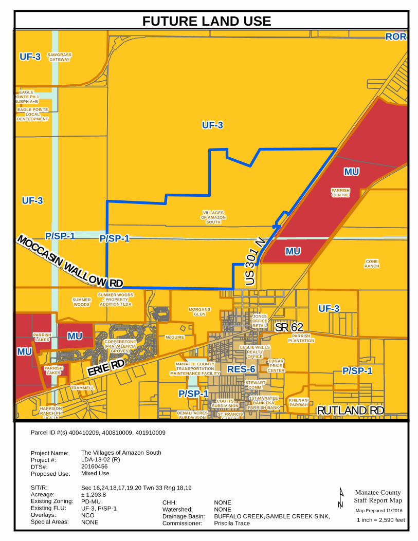
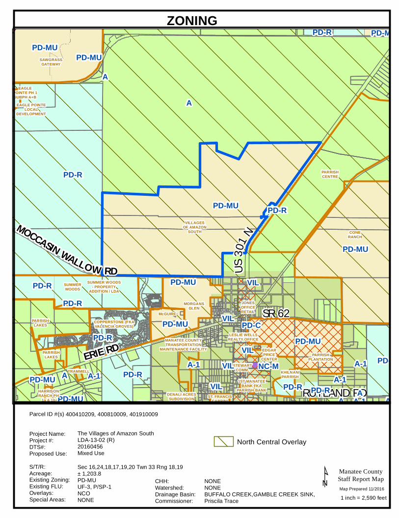
● The Village of Amazon is 1,203.83 +/- acres located at the northwest intersection of Moccasin Wallow Road and US 301, at 12420 US 301 North in Parrish.
History
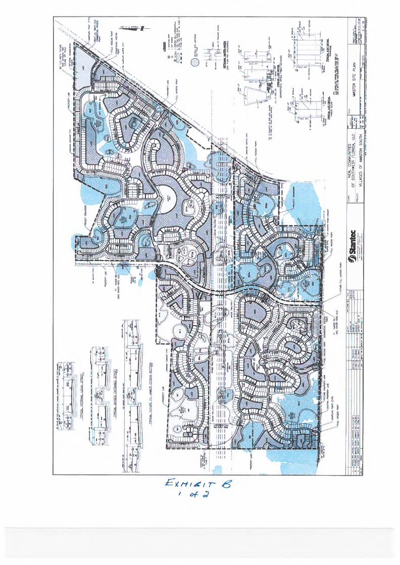
● The Villages of Amazon site was rezoned to Planned Development Mixed Use (PDMU) on September 4, 2014 (PDMU-13-37[Z][P]) with the approval of a Preliminary Site Plan (PSP) for 1,999 residential units and 40,000 square feet of commercial and 20,000 square feet of office space.
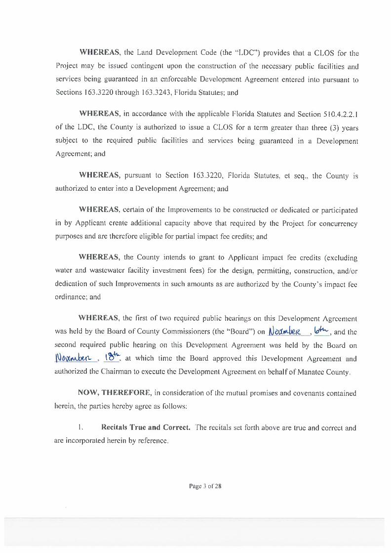
● The original Local Development Agreement was approved on November 18, 2015, and the following activities have been undertaken to date:
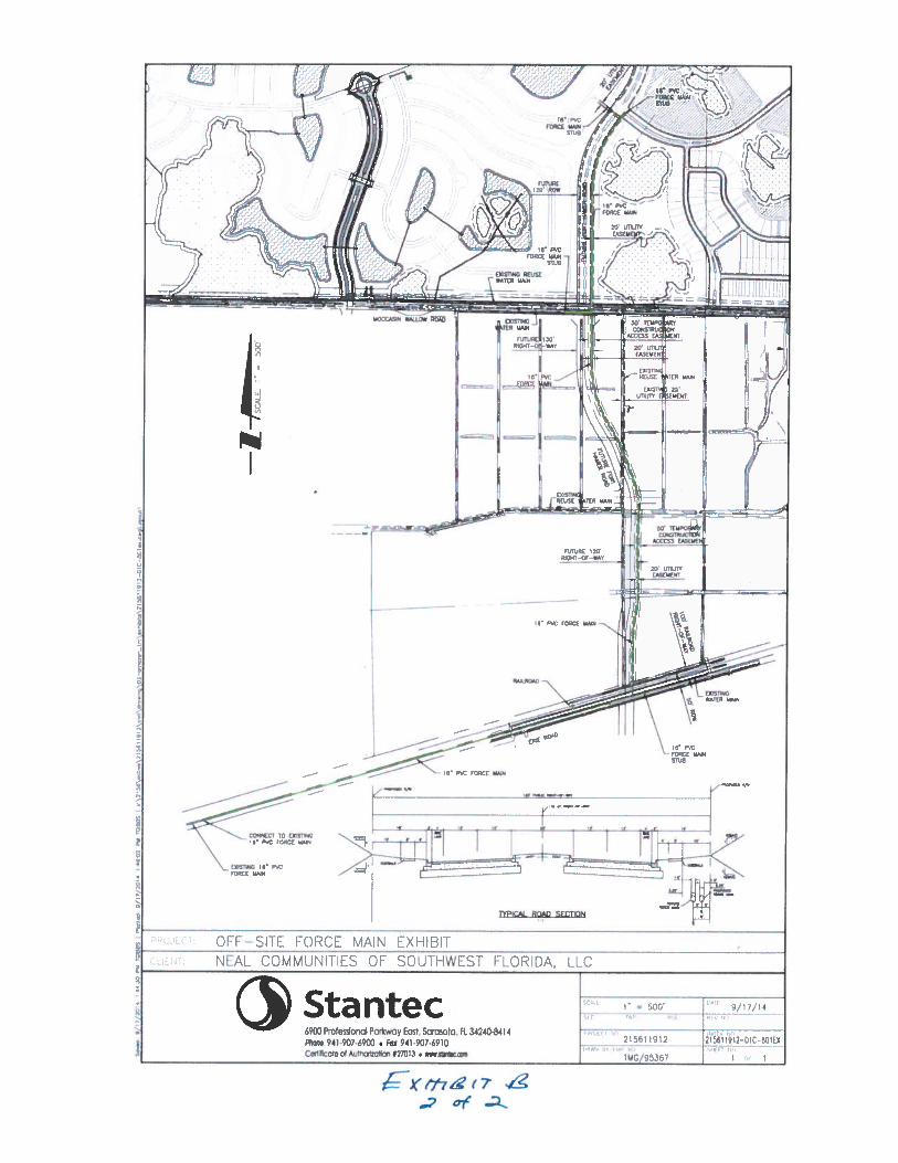
❍ The engineering design, permitting and construction plan approval for the force main from Amazon to Erie Road has been completed.
❍ The rail road crossing north of Erie Road agreement and permit has been executed and completed. ❍ The negotiations for the R/W easement for the force main construction south of Amazon property
boundary is ongoing and should be executed shortly. ❍ Thereafter, the applicant is able to begin the construction and meet the 12/31/2017 time extension
request for this amendment. ● This is the second of two required public hearings. The first hearing was held on November 15, 2016.
County Attorney Review Other (Requires explanation in field below) Explanation of Other William Clague reviewed and responded by email. Reviewing Attorney Clague Instructions to Board Records
The applicant, John Neal, will contact Board Records regarding the recording of the Local Development Agreement. Please provide a copy of the recorded document to [email protected].
Manatee County Government Administrative BuildingFirst Floor, Chambers
December 1, 2016 - 9:00 AM
Cost and Funds Source Account Number and Name N/A Amount and Frequency of Recurring Costs N/A Attachment: Villages of Amazon 1st Amendment (CAO Comments) (2).pdf Attachment: Villages at Amazon South LDA - LDA-13-02 - Recorded on November 20, 2014.pdf Attachment: Maps - FLU, Zoning and Aerials.pdf Attachment: Newspaper Advertising.pdf
Manatee County Government Administrative BuildingFirst Floor, Chambers
December 1, 2016 - 9:00 AM


RUTLAND RD
ERIE RD
MOCCASIN WALLOW RD US30
1 N
SR 62
MU
P/SP-1
ROR
P/SP-1
RES-6
UF-3
P/SP-1
UF-3
UF-3
MU
MU
UF-3
P/SP-1
MU
KHILNANIPARRISH
JONESOFFICERETAIL
SUMMERWOODS
ST. FRANCISCABRINI
STEWARTCOMM.
1ST MANATEEBANK FKA
PARRISH BANKHARRISONRANCH PH
1a & 1bDENALI ACRESSUBDIVISION
MANATEE COUNTYTRANSPORTATION
MAINTENANCE FACILITY
COUTTSSUBDIVISION
EAGLE POINTELOCAL
DEVELOPMENT
TRAMMELL
MORGANSGLEN
PARRISHLAKES
PARRISHLAKES
SUMMER WOODS- PROPERTY
ADDITION / LDA
SAWGRASSGATEWAY
CONERANCH
EAGLEPOINTE PH 1SUBPH A+B
COPPERSTONE(FKA VALENCIA
GROVES)
McGUIRE
VILLAGESOF AMAZON
SOUTH
EDGARPRICE
CENTER
PARRISHCENTRE
PARRISHPLANTATION
LESLIE WELLSREALTYOFFICE
Manatee CountyStaff Report Map
1 inch = 2,590 feet¹
FUTURE LAND USE
Sec 16,24,18,17,19,20 Twn 33 Rng 18,19± 1,203.8PD-MUUF-3, P/SP-1NCONONE
NONENONEBUFFALO CREEK,GAMBLE CREEK SINK,Priscila Trace
400410209, 400810009, 401910009
The Villages of Amazon SouthLDA-13-02 (R)20160456Mixed Use
Parcel ID #(s)
Project Name:Project #:DTS#:Proposed Use:S/T/R:Acreage:Existing Zoning:Existing FLU:Overlays:Special Areas:
CHH:Watershed:Drainage Basin:Commissioner:
Map Prepared 11/2016
RUTLAND RD
ERIE RD
MOCCASIN WALLOW RD US30
1 N
SR 62
A-1
PD-MU
NC-M
A-1
PD-MUKHILNANIPARRISH
JONESOFFICERETAIL
SUMMERWOODS
ST. FRANCISCABRINI
STEWARTCOMM.
1ST MANATEEBANK FKA
PARRISH BANKHARRISONRANCH PH
1a & 1bDENALI ACRESSUBDIVISION
MANATEE COUNTYTRANSPORTATION
MAINTENANCE FACILITY
EAGLE POINTELOCAL
DEVELOPMENT
TRAMMELL
MORGANSGLEN
PARRISHLAKES
PARRISHLAKES
SUMMER WOODS- PROPERTY
ADDITION / LDA
SAWGRASSGATEWAY
CONERANCH
EAGLEPOINTE PH 1SUBPH A+B
COPPERSTONE (FKAVALENCIA GROVES)
McGUIRE
VILLAGESOF AMAZON
SOUTH
EDGARPRICE
CENTER
PARRISHCENTRE
PARRISHPLANTATION
LESLIE WELLSREALTY OFFICE
PD-RA
PD-R
VILPD-R
PD-MU
PD-MU
PD-R
PD-R
A
PD-C
A-1
PD-MU
VIL
PD-MU
A-1
PD-MU
PD-R
PD-R
PD-RA-1
PD-R
VIL
PD-R
A-1
PD-R
PD-MU
A
A
PD-MU
PD-MU
VILVIL
A
Manatee CountyStaff Report Map
1 inch = 2,590 feet¹
ZONING
Sec 16,24,18,17,19,20 Twn 33 Rng 18,19± 1,203.8PD-MUUF-3, P/SP-1NCONONE
NONENONEBUFFALO CREEK,GAMBLE CREEK SINK,Priscila Trace
400410209, 400810009, 401910009
The Villages of Amazon SouthLDA-13-02 (R)20160456Mixed Use
Parcel ID #(s)
Project Name:Project #:DTS#:Proposed Use:S/T/R:Acreage:Existing Zoning:Existing FLU:Overlays:Special Areas:
CHH:Watershed:Drainage Basin:Commissioner:
Map Prepared 11/2016
North Central Overlay
RUTLAND RD
ERIE RD
MOCCASIN WALLO W RD US30
1 N
SR 62
KHILNANIPARRISH
JONESOFFICERETAIL
SUMMERWOODS
ST. FRANCISCABRINI
STEWARTCOMM.
1ST MANATEEBANK FKA
PARRISH BANKHARRISONRANCH PH
1a & 1bDENALI ACRESSUBDIVISION
MANATEE COUNTYTRANSPORTATION
MAINTENANCE FACILITY
COUTTSSUBDIVISION
EAGLE POINTELOCAL
DEVELOPMENT
TRAMMELL
MORGANSGLEN
PARRISHLAKES
PARRISHLAKES
SUMMER WOODS- PROPERTY
ADDITION / LDA
SAWGRASSGATEWAY
CONERANCH
EAGLEPOINTE PH 1SUBPH A+B
COPPERSTONE(FKA VALENCIA
GROVES)
McGUIRE
VILLAGESOF AMAZON
SOUTH
EDGARPRICE
CENTER
PARRISHCENTRE
PARRISHPLANTATION
LESLIE WELLSREALTYOFFICE
Manatee CountyStaff Report Map
1 inch = 2,590 feet¹
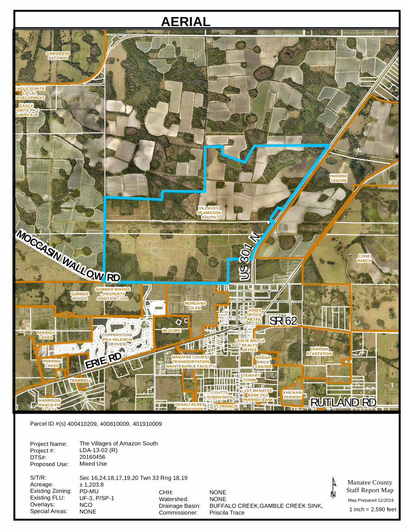
AERIAL
Sec 16,24,18,17,19,20 Twn 33 Rng 18,19± 1,203.8PD-MUUF-3, P/SP-1NCONONE
NONENONEBUFFALO CREEK,GAMBLE CREEK SINK,Priscila Trace
400410209, 400810009, 401910009
The Villages of Amazon SouthLDA-13-02 (R)20160456Mixed Use
Parcel ID #(s)
Project Name:Project #:DTS#:Proposed Use:S/T/R:Acreage:Existing Zoning:Existing FLU:Overlays:Special Areas:
CHH:Watershed:Drainage Basin:Commissioner:
Map Prepared 11/2016
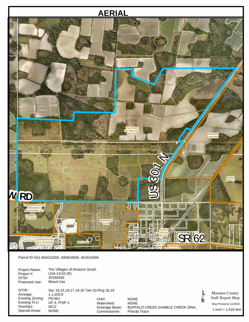
MOCCASIN WALLOW RD US30
1 N
SR 62JONESOFFICERETAIL
SUMMERWOODS MORGANS
GLEN
SUMMER WOODS- PROPERTY
ADDITION / LDA
CONERANCH
COPPERSTONE(FKA VALENCIA
GROVES)McGUIRE
VILLAGESOF AMAZON
SOUTH PARRISHCENTRE
PARRISHPLANTATION
Manatee CountyStaff Report Map
1 inch = 1,618 feet¹
AERIAL
Sec 16,24,18,17,19,20 Twn 33 Rng 18,19± 1,203.8PD-MUUF-3, P/SP-1NCONONE
NONENONEBUFFALO CREEK,GAMBLE CREEK SINK,Priscila Trace
400410209, 400810009, 401910009
The Villages of Amazon SouthLDA-13-02 (R)20160456Mixed Use
Parcel ID #(s)
Project Name:Project #:DTS#:Proposed Use:S/T/R:Acreage:Existing Zoning:Existing FLU:Overlays:Special Areas:
CHH:Watershed:Drainage Basin:Commissioner:
Map Prepared 11/2016
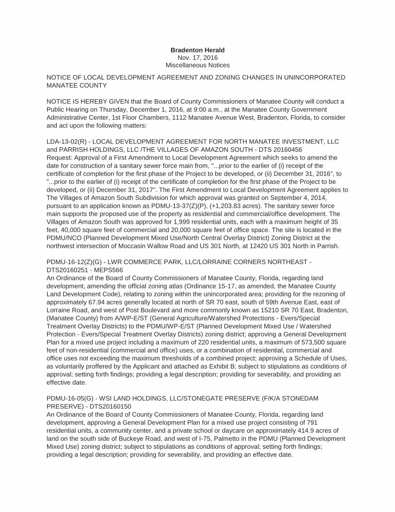
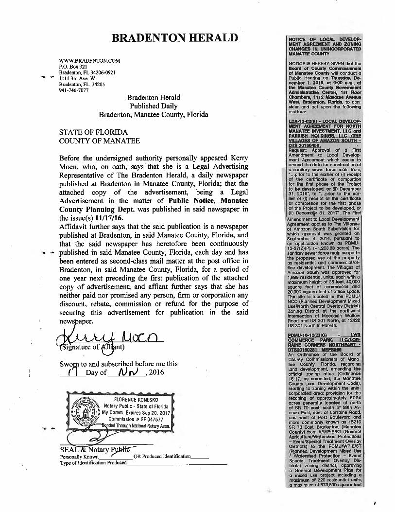
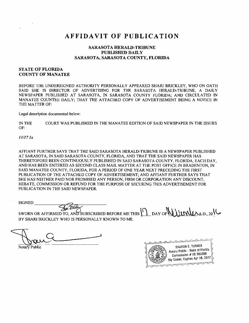
Bradenton Herald Nov. 17, 2016
Miscellaneous Notices
NOTICE OF LOCAL DEVELOPMENT AGREEMENT AND ZONING CHANGES IN UNINCORPORATED
MANATEE COUNTY
NOTICE IS HEREBY GIVEN that the Board of County Commissioners of Manatee County will conduct a
Public Hearing on Thursday, December 1, 2016, at 9:00 a.m., at the Manatee County Government
Administrative Center, 1st Floor Chambers, 1112 Manatee Avenue West, Bradenton, Florida, to consider
and act upon the following matters:
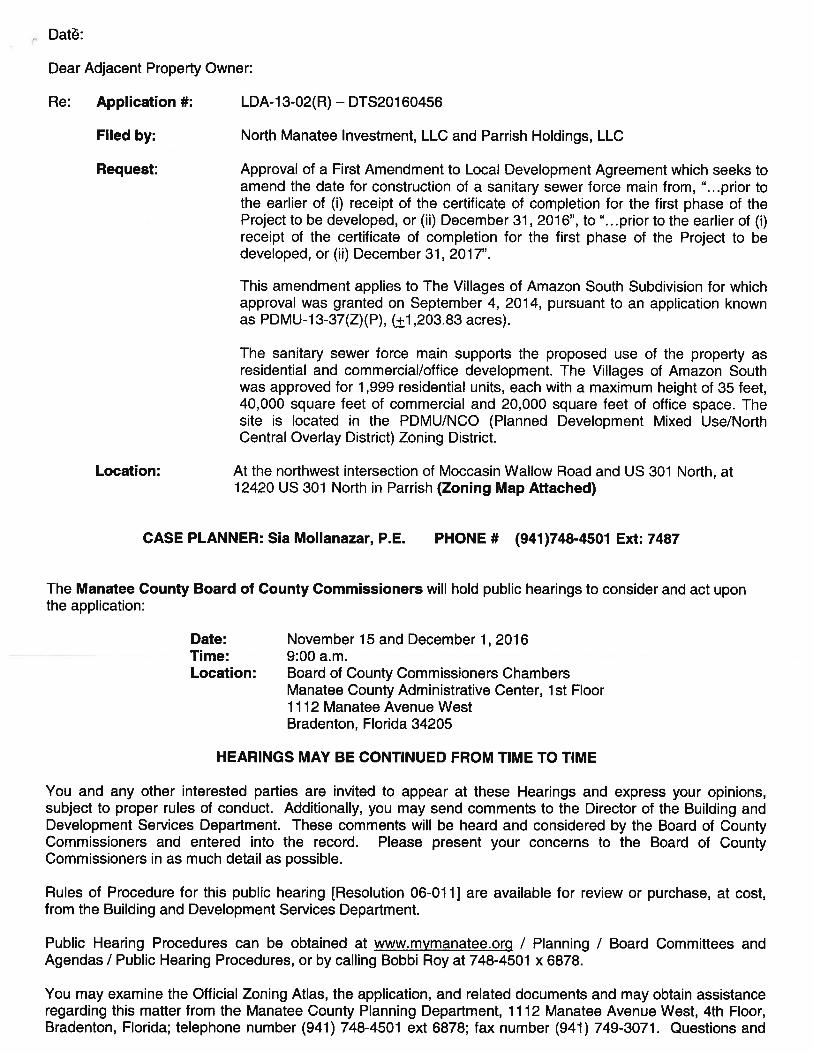
LDA-13-02(R) - LOCAL DEVELOPMENT AGREEMENT FOR NORTH MANATEE INVESTMENT, LLC
and PARRISH HOLDINGS, LLC /THE VILLAGES OF AMAZON SOUTH - DTS 20160456
Request: Approval of a First Amendment to Local Development Agreement which seeks to amend the
date for construction of a sanitary sewer force main from, "...prior to the earlier of (i) receipt of the
certificate of completion for the first phase of the Project to be developed, or (ii) December 31, 2016", to
"...prior to the earlier of (i) receipt of the certificate of completion for the first phase of the Project to be
developed, or (ii) December 31, 2017". The First Amendment to Local Development Agreement applies to
The Villages of Amazon South Subdivision for which approval was granted on September 4, 2014,
pursuant to an application known as PDMU-13-37(Z)(P), (+1,203.83 acres). The sanitary sewer force
main supports the proposed use of the property as residential and commercial/office development. The
Villages of Amazon South was approved for 1,999 residential units, each with a maximum height of 35
feet, 40,000 square feet of commercial and 20,000 square feet of office space. The site is located in the
PDMU/NCO (Planned Development Mixed Use/North Central Overlay District) Zoning District at the
northwest intersection of Moccasin Wallow Road and US 301 North, at 12420 US 301 North in Parrish.
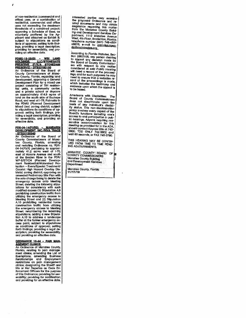
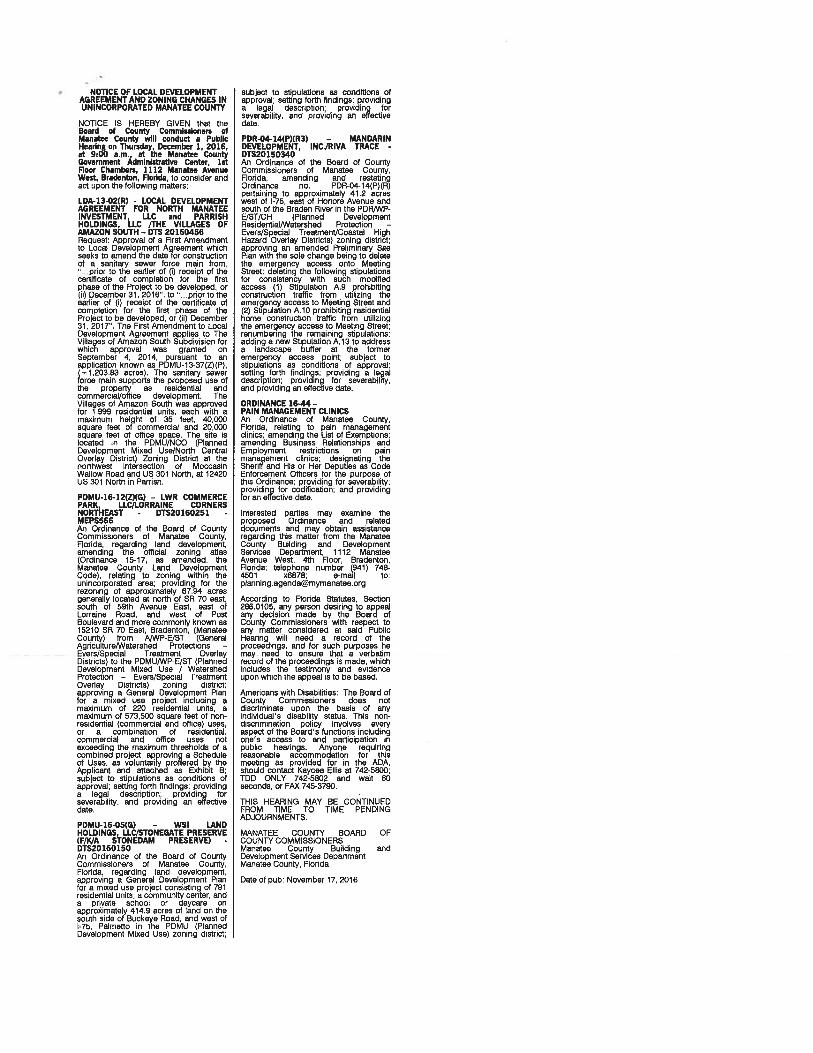
PDMU-16-12(Z)(G) - LWR COMMERCE PARK, LLC/LORRAINE CORNERS NORTHEAST -
DTS20160251 - MEPS566
An Ordinance of the Board of County Commissioners of Manatee County, Florida, regarding land
development, amending the official zoning atlas (Ordinance 15-17, as amended, the Manatee County
Land Development Code), relating to zoning within the unincorporated area; providing for the rezoning of
approximately 67.94 acres generally located at north of SR 70 east, south of 59th Avenue East, east of
Lorraine Road, and west of Post Boulevard and more commonly known as 15210 SR 70 East, Bradenton,
(Manatee County) from A/WP-E/ST (General Agriculture/Watershed Protections - Evers/Special
Treatment Overlay Districts) to the PDMU/WP-E/ST (Planned Development Mixed Use / Watershed
Protection - Evers/Special Treatment Overlay Districts) zoning district; approving a General Development
Plan for a mixed use project including a maximum of 220 residential units, a maximum of 573,500 square
feet of non-residential (commercial and office) uses, or a combination of residential, commercial and
office uses not exceeding the maximum thresholds of a combined project; approving a Schedule of Uses,
as voluntarily proffered by the Applicant and attached as Exhibit B; subject to stipulations as conditions of
approval; setting forth findings; providing a legal description; providing for severability, and providing an
effective date.
PDMU-16-05(G) - WSI LAND HOLDINGS, LLC/STONEGATE PRESERVE (F/K/A STONEDAM
PRESERVE) - DTS20160150
An Ordinance of the Board of County Commissioners of Manatee County, Florida, regarding land
development, approving a General Development Plan for a mixed use project consisting of 791
residential units, a community center, and a private school or daycare on approximately 414.9 acres of
land on the south side of Buckeye Road, and west of I-75, Palmetto in the PDMU (Planned Development
Mixed Use) zoning district; subject to stipulations as conditions of approval; setting forth findings;
providing a legal description; providing for severability, and providing an effective date.
PDR-04-14(P)(R3) - MANDARIN DEVELOPMENT, INC./RIVA TRACE - DTS20150340
An Ordinance of the Board of County Commissioners of Manatee County, Florida, amending and
restating Ordinance no. PDR-04-14(P)(R) pertaining to approximately 41.2 acres west of I-75, east of
Honore Avenue and south of the Braden River in the PDR/WP-E/ST/CH (Planned Development
Residential/Watershed Protection - Evers/Special Treatment/Coastal High Hazard Overlay Districts)
zoning district; approving an amended Preliminary Site Plan with the sole change being to delete the
emergency access onto Meeting Street; deleting the following stipulations for consistency with such
modified access (1) Stipulation A.9 prohibiting construction traffic from utilizing the emergency access to
Meeting Street and (2) Stipulation A.10 prohibiting residential home construction traffic from utilizing the
emergency access to Meeting Street; renumbering the remaining stipulations; adding a new Stipulation
A.13 to address a landscape buffer at the former emergency access point; subject to stipulations as
conditions of approval; setting forth findings; providing a legal description; providing for severability, and
providing an effective date.
ORDINANCE 16-44 - PAIN MANAGEMENT CLINICS
An Ordinance of Manatee County, Florida, relating to pain management clinics; amending the List of
Exemptions; amending Business Relationships and Employment restrictions on pain management clinics;
designating the Sheriff and His or Her Deputies as Code Enforcement Officers for the purpose of this
Ordinance; providing for severability; providing for codification; and providing for an effective date.
Interested parties may examine the proposed Ordinance and related documents and may obtain
assistance regarding this matter from the Manatee County Building and Development Services
Department, 1112 Manatee Avenue West, 4th Floor, Bradenton, Florida; telephone number (941) 748-
4501 x6878; e-mail to: [email protected]
According to Florida Statutes, Section 286.0105, any person desiring to appeal any decision made by the
Board of County Commissioners with respect to any matter considered at said Public Hearing will need a
record of the proceedings, and for such purposes he may need to ensure that a verbatim record of the
proceedings is made, which includes the testimony and evidence upon which the appeal is to be based.
Americans with Disabilities: The Board of County Commissioners does not discriminate upon the basis of
any individual's disability status. This non-discrimination policy involves every aspect of the Board's
functions including one's access to and participation in public hearings. Anyone requiring reasonable
accommodation for this meeting as provided for in the ADA, should contact Kaycee Ellis at 742-5800;
TDD ONLY 742-5802 and wait 60 seconds, or FAX 745-3790.
THIS HEARING MAY BE CONTINUED FROM TIME TO TIME PENDING ADJOURNMENTS.
MANATEE COUNTY BOARD OF COUNTY COMMISSIONERS
Manatee County Building
and Development Services
Department