Embed Size (px)
Citation preview
Yuba County Water Agency Yuba River Development Project
FERC Project No. 2246
September 2009 Preliminary Information Package Geology and Soils ©2009, Yuba County Water Agency Page 7.1-1
7.1 Geology and Soils 7.1.1 Overview This section provides information regarding existing geology and soil conditions in the vicinity1 of Yuba County Water Agency’s (YCWA or Licensee) Yuba River Development Project (Project). Besides this general introductory information, this section is divided into six subsections: Sections 7.1.2 through 7.1.6 provide general information regarding geologic features, tectonic history, mineral resources, physiography, geomorphology, and soils in the Project Region;2 and Section 7.1.7 describes existing, relevant, and reasonably available information regarding geology and soils in areas upstream of the Project (i.e., on the Middle Yuba River upstream of Our House Diversion Dam, on Oregon Creek upstream of Log Cabin Diversion Dam, and on the North Yuba River upstream of New Bullards Bar Reservoir), within the Project Area,3 and downstream of the Project (i.e., on the Yuba River downstream of the United States Army Corps of Engineer’s (USACE) Daguerre Point Dam). 7.1.2 Geologic Features The Project Region geology is a product of many complex interactions between both large-scale and small-scale processes. These processes include both world-scale plate tectonics, where continents are periodically created and pulled apart, and smaller scale local processes, such as erosion and sedimentation, which constantly change the landscape. The Sierra Nevada physiographic province is a product of all these processes, and the geology in the Project Region exhibits many of these influences. The relevant geologic history of the Project Region can be summarized by describing its development for the period spanning the mid-Paleozoic (i.e., approximately 300-400 million years ago, or Mya) to the present day. The basement rocks were in-placed as an oceanic plate in an ancient sea during a tectonically quiet period through about 225 Mya. The basement rock and overlaying sediments began to move westward due to the formation of a plate subduction boundary on what was then the western margin of the North American land mass (Schweickert et al. 1984), east of the present day Sierra Nevada. Paleozoic and Mesozoic terrains were initially deposited as island-arc rocks and were accreted and subducted beneath the continent. Metamorphic rocks were accreted onto the continental margin in long, linear strips, striking roughly parallel to the present day Sierra crest. The subduction zone supplied the mantle with new rock to a depth great enough for the subducting plate to melt. The resulting magma eventually rose as both surface volcanic rock and as subsurface granitic plutons. The granitic plutons compose much of the core of the current Sierra Nevada. Concurrent with the
1 For the purposes of this document, the Project Vicinity is defined as the area surrounding the Project on the order of a United
States Geological Survey (USGS) 1:24,000 topographic quadrangle. 2 For the purpose of this document, the Project Region is defined as the area surrounding the Project on the order of a county or
national forest. 3 For the purposes of this document, the Project Area is defined as the area within the Federal Energy Regulatory Commission
(FERC) Project Boundary and the land immediately surrounding the FERC Project Boundary (i.e., within approximately 0.25-mile of the FERC Project Boundary) and includes Project-affected reaches between facilities and downstream to the next major water controlling feature or structure.
Yuba County Water Agency Yuba River Development Project FERC Project No. 2246
Geology and Soils Preliminary Information Package September 2009 Page 7.1-2 © 2009, Yuba County Water Agency
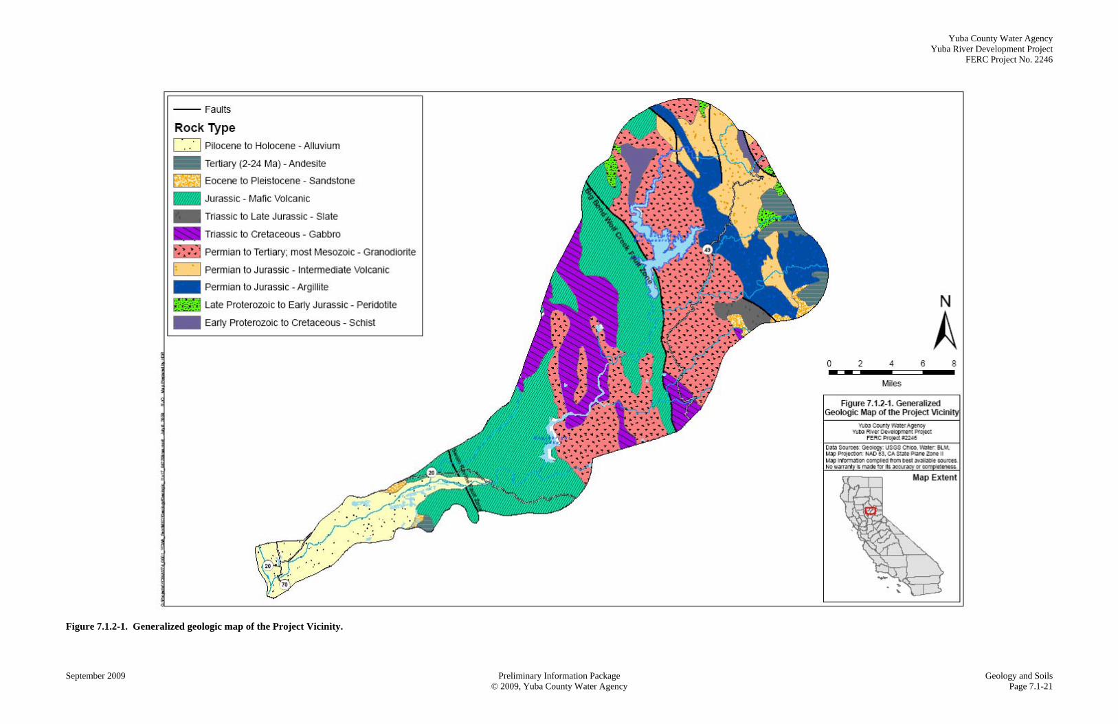
development of the plutons, the hot magma intruded into the folded sedimentary rocks, resulting in metamorphism and the creation of the famous Sierra Nevada gold deposits in the fractures (USFS 2002). Uplift along the eastern margin of the Sierra produced erosion through the beginning of the Tertiary Period (65 Mya), exposing the gold veins that had been created during the Mesozoic. These gold veins were eroded and deposited throughout the ancestral Yuba River, which ran approximately north to south across the peneplain that existed at the time. The “Tertiary River Gravels” are the source for much of the 19th century mining in the Yuba River drainages (USFS 2002). The middle Tertiary was a time of volcanic eruptions that deposited lava, mudflows, pyroclastic flows, and ash throughout the Yuba River Basin. These deposits filled many pre-existing drainages such as the ancestral Yuba River, as well as inplacing a cap of volcanic rock/volcanic debris on the existing granite and remnants of the early Mesozoic sedimentary rocks. Uplift along the eastern Sierra Nevada margin resulted in the predominantly east-to-west incised drainages that are evident today. Subsequent to this latest orogeny of eruptions and mudflows, three late Quaternary glacial stages, each with multiple sub-stages, occurred in the northwestern Sierra Nevada (James 2003; James et al. 2002). The bedrock geology in the Project Region is composed of Paleozoic metasediments and metavolcanics (i.e., undifferentiated), Paleozoic and Mesozoic granitics (i.e., Valley Pluton, Cascade Pluton, Yuba Rivers Pluton), and Mesozoic ophiolite (i.e., Smartville4 Complex). Eocene auriferous sediments, the Tertiary gold-bearing river gravels, deposited by the ancestral Yuba River, also exist on eastern portions of the Project Region. Figure 7.1.2-1, located at the end of this section, presents a generalized map of the parent material in the Project Vicinity. Table 7.1.2-1 below presents the relative percent of each rock type to the total acreage in the Project Vicinity. Table 7.1.2-1. Description of generalized geologic rock types in the Project Vicinity.
Rock Type Area
(acres) Percent
(%) Description Age
Granodiorite 62,967 27 granitic rocks, mostly granodiorite Permian to Tertiary
Mafic Volcanic Rocks 63,554 27 metavolcanic rock, part of ophiolite complex Jurassic
Gabbro 25,198 11 part of ophiolite complex Triassic to Cretaceous
Alluvium 22,050 10 Terraces, alluvium, riverbanks associated with
Yuba River corridor Pliocene to Holocene
Argillite 21,181 9 weakly metamorphosed metasedimentary rock Permian to Jurassic Intermediate Volcanic Rock
18,772 8 metavolcanic rock Permian to Jurassic
Andesite 4,852 2 lava flows/pyroclastic flows Tertiary (2-24 Mya)
Peridotite 2,439 1 ultramafic rock associated with the Big Bend
Wolf Creek Fault Zone Later Proterozoic to Early Jurassic
Sandstone 2,315 1 ancestral Yuba River deposits Eocene to Pleistocene
Slate 2,484 1 undifferentiated metasedimentary Triassic to Late Cretaceous
Schist 3,235 1 metasedimentary schist Early Proterozoic to Cretaceous
4 In 2008, the people of this community petitioned to have the name changed to Smartsville, with an ‘s’. However, the USGS
gage refers to the former spelling of the community name. Therefore in this document, the community is referred to as such.
Yuba County Water Agency Yuba River Development Project
FERC Project No. 2246
September 2009 Preliminary Information Package Geology and Soils ©2009, Yuba County Water Agency Page 7.1-3
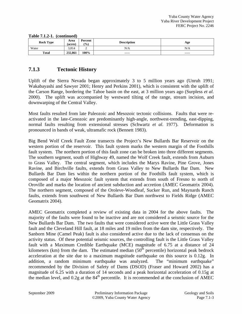
Table 7.1.2-1. (continued) Rock Type
Area (acres)
Percent (%)
Description Age
Water 3,814 2 N/A N/A
Total 232,861 100% ----- -----
7.1.3 Tectonic History Uplift of the Sierra Nevada began approximately 3 to 5 million years ago (Unruh 1991; Wakabayashi and Sawyer 2001; Henry and Perkins 2001), which is consistent with the uplift of the Carson Range, bordering the Tahoe basin on the east, at 3 million years ago (Surpless et al. 2000). The uplift was accompanied by westward tilting of the range, stream incision, and downwarping of the Central Valley. Most faults resulted from late Paleozoic and Mesozoic tectonic collisions. Faults that were re-activated in the late-Cenozoic are predominantly high-angle, northwest-trending, east-dipping, normal faults resulting from extensional stresses (Schwartz et al. 1977). Deformation is pronounced in bands of weak, ultramafic rock (Bennett 1983). Big Bend Wolf Creek Fault Zone transects the Project’s New Bullards Bar Reservoir on the western portion of the reservoir. This fault system marks the western margin of the Foothills fault system. The northern portion of this fault zone can be broken into three different segments. The southern segment, south of Highway 49, named the Wolf Creek fault, extends from Auburn to Grass Valley. The central segment, which includes the Marys Ravine, Pine Grove, Jones Ravine, and Birchville faults, extends from Grass Valley to New Bullards Bar Dam. New Bullards Bar Dam lies within the northern portion of the Foothills fault system, which is composed of a major Mesozoic fault system that extends from south of Fresno to north of Oroville and marks the location of ancient subduction and accretion (AMEC Geomatrix 2004). The northern segment, composed of the Oroleve-Woodleaf, Sucker Run, and Maynards Ranch faults, extends from southwest of New Bullards Bar Dam northwest to Fields Ridge (AMEC Geomatrix 2004). AMEC Geomatrix completed a review of existing data in 2004 for the above faults. The majority of the faults were found to be inactive and are not considered a seismic source for the New Bullards Bar Dam. The two faults that were considered active were the Little Grass Valley fault and the Cleveland Hill fault, at 18 miles and 19 miles from the dam site, respectively. The Sanborn Mine (Camel Peak) fault is also considered active due to the lack of consensus on the activity status. Of these potential seismic sources, the controlling fault is the Little Grass Valley fault with a Maximum Credible Earthquake (MCE) magnitude of 6.75 at a distance of 24 kilometers (km) from the dam. The estimated median (50th percentile) horizontal peak bedrock acceleration at the site due to a maximum magnitude earthquake on this source is 0.12g. In addition, a random minimum earthquake was analyzed. The “minimum earthquake” recommended by the Division of Safety of Dams (DSOD) (Fraser and Howard 2002) has a magnitude of 6.25 with a duration of 14 seconds and a peak horizontal acceleration of 0.15g at the median level, and 0.2g at the 84th percentile. It is recommended at the conclusion of AMEC
Yuba County Water Agency Yuba River Development Project FERC Project No. 2246
Geology and Soils Preliminary Information Package September 2009 Page 7.1-4 © 2009, Yuba County Water Agency
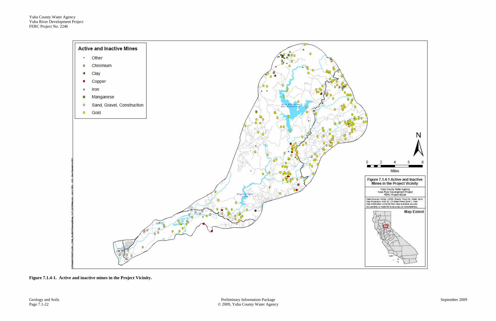
Geomatrix’s report that the “minimum earthquake” of 6.25 should be used for analyses of the main dam (AMEC Geomatrix 2004). The Swain Ravine Fault Zone is located approximately 18 miles east of the confluence of the Feather and Yuba rivers, parallel to the Big Bend Wolf Creek Fault Zone. The Cleveland Hill Fault is the northern extension of this zone near Lake Orville. The 1975 Oroville earthquake, which occurred on the Cleveland Hill fault, also developed cracks over the northern portions of the Swain Ravine fault (Page and Sawyer 2004 [Appendix E of AMEC Geomatrix 2004]). The locations of the Swain Ravine and Big Bend Wolf Creek Fault Zone are depicted on Figure 7.1.2-1. 7.1.4 Mineral Resources Gold mining is the dominant mineral resource activity, the dominant influence on how the Yuba River looks today, and the primary reason people settled in the area. Lode gold mining began in 1853 (DOC 2003) with exploitation of surface deposits of placer gold, followed by riverbed, quartz, and alluvial gravel mining. Deep mines and gigantic hydraulic operations followed as the more-easily accessed deposits were depleted (SNEP 1997). Because lumber and water resources were needed to support mining, camps and towns were needed as well. After 1900, quartz gold mining grew in importance. Many abandoned and active mines are scattered throughout the Yuba River system, and damage from historic hydraulic mining for gold is visible throughout the river corridor. Mercury was imported from the Coast Range and used for gold extraction. Mercury remains sequestered in sediments within the Project Region and continues to be a potential source of mercury to Yuba River surface water. For a discussion of mercury, refer to the Water Resources section of this Preliminary Information Package (Section 7.2). Erosion of exposed mining material and transport of it to local river channels are the most likely indirect effects of mining operations, with sediment transport potentially affecting stream channel morphology. The west edge of the north half of the Sierra Nevada range has many other important minerals (Diggles et al. 1996). While the Sawyer Decision of 1884 caused the end of placer gold mining, other gold mining techniques also declined after 1900. Nevertheless, more than 20 other minerals were mined between 1900 and 1960. Most of the entire western belt is geologically permissive for gold, chromium (i.e., chromite ore), copper, and manganese. “Geologically permissive” is defined by the environment of formation, including estimates of undiscovered resources to a depth of 0.6 mile, though not all deposits are known. About a third of the belt has one or more of these metals. Also included are barite, molybdenite, and tungsten, which were also important in the development of the communities near the Sierra Nevada range. Chrysotile (i.e., white asbestos) is found in veins in serpentinized ultramafic rocks near margins of serpentinite bodies. Serpentine and ultramafic rocks are generally found along fault zones such as the Big Bend Wolf Creek Fault Zone in the Project Area.
Yuba County Water Agency Yuba River Development Project
FERC Project No. 2246
September 2009 Preliminary Information Package Geology and Soils ©2009, Yuba County Water Agency Page 7.1-5
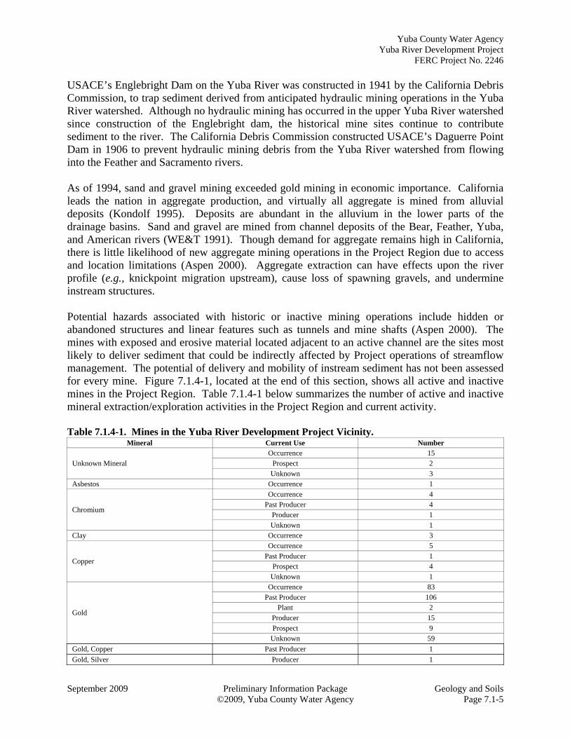
USACE’s Englebright Dam on the Yuba River was constructed in 1941 by the California Debris Commission, to trap sediment derived from anticipated hydraulic mining operations in the Yuba River watershed. Although no hydraulic mining has occurred in the upper Yuba River watershed since construction of the Englebright dam, the historical mine sites continue to contribute sediment to the river. The California Debris Commission constructed USACE’s Daguerre Point Dam in 1906 to prevent hydraulic mining debris from the Yuba River watershed from flowing into the Feather and Sacramento rivers. As of 1994, sand and gravel mining exceeded gold mining in economic importance. California leads the nation in aggregate production, and virtually all aggregate is mined from alluvial deposits (Kondolf 1995). Deposits are abundant in the alluvium in the lower parts of the drainage basins. Sand and gravel are mined from channel deposits of the Bear, Feather, Yuba, and American rivers (WE&T 1991). Though demand for aggregate remains high in California, there is little likelihood of new aggregate mining operations in the Project Region due to access and location limitations (Aspen 2000). Aggregate extraction can have effects upon the river profile (e.g., knickpoint migration upstream), cause loss of spawning gravels, and undermine instream structures. Potential hazards associated with historic or inactive mining operations include hidden or abandoned structures and linear features such as tunnels and mine shafts (Aspen 2000). The mines with exposed and erosive material located adjacent to an active channel are the sites most likely to deliver sediment that could be indirectly affected by Project operations of streamflow management. The potential of delivery and mobility of instream sediment has not been assessed for every mine. Figure 7.1.4-1, located at the end of this section, shows all active and inactive mines in the Project Region. Table 7.1.4-1 below summarizes the number of active and inactive mineral extraction/exploration activities in the Project Region and current activity. Table 7.1.4-1. Mines in the Yuba River Development Project Vicinity.
Mineral Current Use Number
Unknown Mineral Occurrence 15
Prospect 2 Unknown 3
Asbestos Occurrence 1
Chromium
Occurrence 4 Past Producer 4
Producer 1 Unknown 1
Clay Occurrence 3
Copper
Occurrence 5
Past Producer 1 Prospect 4
Unknown 1
Gold
Occurrence 83 Past Producer 106
Plant 2
Producer 15 Prospect 9
Unknown 59
Gold, Copper Past Producer 1
Gold, Silver Producer 1
Yuba County Water Agency Yuba River Development Project FERC Project No. 2246
Geology and Soils Preliminary Information Package September 2009 Page 7.1-6 © 2009, Yuba County Water Agency
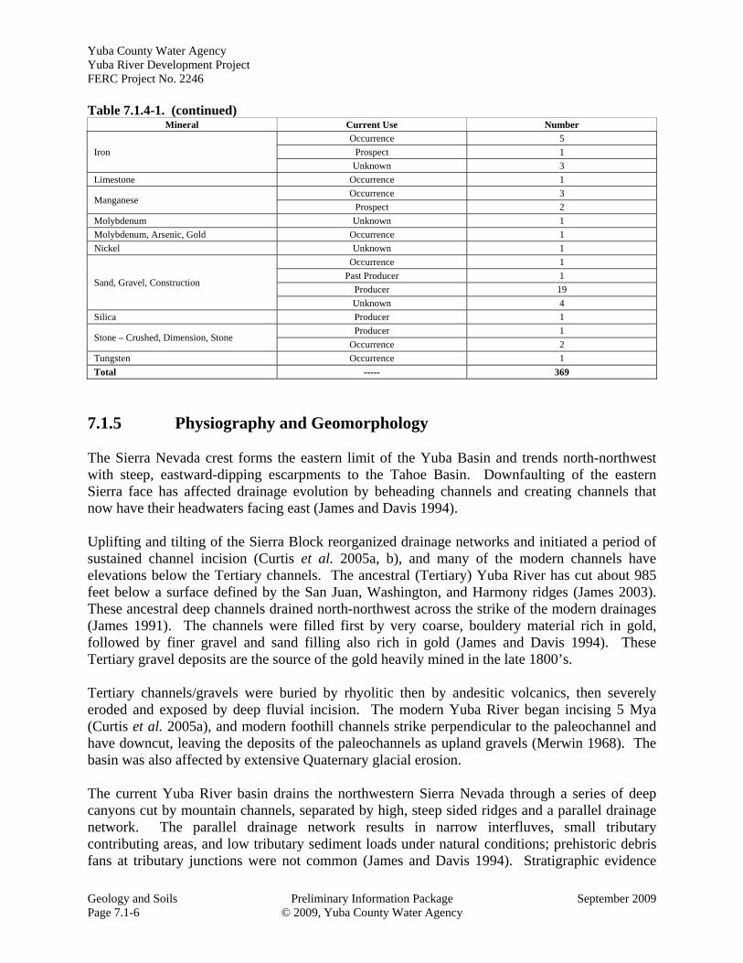
Table 7.1.4-1. (continued) Mineral Current Use Number
Iron
Occurrence 5
Prospect 1
Unknown 3
Limestone Occurrence 1
Manganese Occurrence 3
Prospect 2
Molybdenum Unknown 1
Molybdenum, Arsenic, Gold Occurrence 1
Nickel Unknown 1
Sand, Gravel, Construction
Occurrence 1
Past Producer 1
Producer 19
Unknown 4
Silica Producer 1
Stone – Crushed, Dimension, Stone Producer 1
Occurrence 2
Tungsten Occurrence 1
Total ----- 369
7.1.5 Physiography and Geomorphology The Sierra Nevada crest forms the eastern limit of the Yuba Basin and trends north-northwest with steep, eastward-dipping escarpments to the Tahoe Basin. Downfaulting of the eastern Sierra face has affected drainage evolution by beheading channels and creating channels that now have their headwaters facing east (James and Davis 1994). Uplifting and tilting of the Sierra Block reorganized drainage networks and initiated a period of sustained channel incision (Curtis et al. 2005a, b), and many of the modern channels have elevations below the Tertiary channels. The ancestral (Tertiary) Yuba River has cut about 985 feet below a surface defined by the San Juan, Washington, and Harmony ridges (James 2003). These ancestral deep channels drained north-northwest across the strike of the modern drainages (James 1991). The channels were filled first by very coarse, bouldery material rich in gold, followed by finer gravel and sand filling also rich in gold (James and Davis 1994). These Tertiary gravel deposits are the source of the gold heavily mined in the late 1800’s. Tertiary channels/gravels were buried by rhyolitic then by andesitic volcanics, then severely eroded and exposed by deep fluvial incision. The modern Yuba River began incising 5 Mya (Curtis et al. 2005a), and modern foothill channels strike perpendicular to the paleochannel and have downcut, leaving the deposits of the paleochannels as upland gravels (Merwin 1968). The basin was also affected by extensive Quaternary glacial erosion. The current Yuba River basin drains the northwestern Sierra Nevada through a series of deep canyons cut by mountain channels, separated by high, steep sided ridges and a parallel drainage network. The parallel drainage network results in narrow interfluves, small tributary contributing areas, and low tributary sediment loads under natural conditions; prehistoric debris fans at tributary junctions were not common (James and Davis 1994). Stratigraphic evidence
Yuba County Water Agency Yuba River Development Project
FERC Project No. 2246
September 2009 Preliminary Information Package Geology and Soils ©2009, Yuba County Water Agency Page 7.1-7
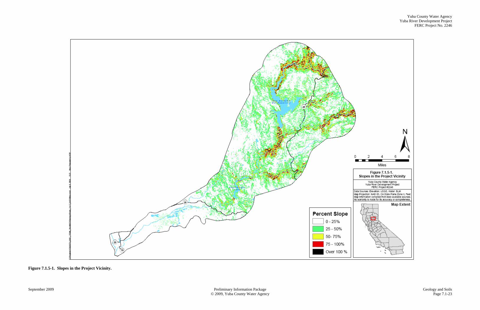
indicates the presence of stepped, Quaternary terraces similar to piedmont channels flowing out of the Sierra (James 1988), but these terraces are generally now buried by mining sediment. The effects of hydraulic mining are particularly significant where the Feather and Yuba rivers converge near Marysville (EDAW 2006). At the mouth of the Yuba River at the south edge of Marysville, 70 feet or more of sediment eventually filled the river channel. Upstream of Marysville, entire communities were buried under more than 40 feet of silt and gravel (Hoover et al. 1990). Sacramento River Flood Control Project levees were constructed along the Feather and Yuba rivers and their tributaries to prevent flooding of valley communities. These levees prevented these communities from becoming buried under the sediments that were washed down from the mountains. The levees were built even higher and designed to confine the floodwaters to a relatively narrow channel that would maintain sufficiently high velocities to efficiently convey sediment through the system, reducing the amount of dredging necessary to maintain navigation. As a result of the levees, Marysville, Olivehurst, and Linda are now many feet below the floodwater levels of the Feather and Yuba rivers. Between 1852 and 1906, an estimated 366,500,000 cubic yards of hydraulic mining debris moved downstream from the upland mining areas of the greater Yuba River watershed and was deposited in the lower Yuba River, causing aggradation on the order of 26-85 feet (Adler, 1980). This massive sedimentation in the channel and floodplains transformed the lower Yuba River into a braided, unstable stream system. Adler (1980) states that by 1906, the supply of hydraulic mining debris from upland areas was mostly depleted and degradation became the dominant process along the lower Yuba River. Based upon historical channel cross-section data collected along the lower Yuba River during the late 1800s and early 1900s and updated in 1979, Adler concluded that the lower Yuba River channel below USACE’s Englebright Dam had attained equilibrium by 1940 to a channel morphology similar to its pre-1849 channel configuration (i.e., single stable channel, similar channel elevation), except the stream channel is now bordered by large cobble training walls that constrain the channel width in many sections (Adler, 1980). The study further concludes that since 1940, almost 90 percent of the hydraulic mining debris deposited in the lower Yuba River remains today as quasi-permanent deposits in the floodplains. The cobble training walls, along with the massive deposit of hydraulic mining debris behind the training walls, are now a stable, generally immobile part of the Lower Yuba River system. More recently, studies by the Three Rivers Levee Improvement Authority broadly state that as hydraulic mining sediment supplies decline, the rivers again will adjust to a new equilibrium. Ultimately, hundreds to thousands of years in the future, it is likely that the river channels will cut down to their pre-mining elevations and will begin migrating laterally (TRLIA 2006). 7.1.5.1 Erosion and Sedimentation Hill slopes in the Project Region are generally less than 50 percent. The exceptions are within the inner gorges where channels have cut deeply into the underlying parent material. Hillslope steepness is shown Figure 7.1.5-1, located at the end of this section. In the Project Region, hillslope erosion rates are low compared to more rapidly eroding landscapes such as the Pacific Northwest. The Sierra Nevada mountain block continues to uplift,
Yuba County Water Agency Yuba River Development Project FERC Project No. 2246
Geology and Soils Preliminary Information Package September 2009 Page 7.1-8 © 2009, Yuba County Water Agency
and the rate of downcutting and erosion depends in large part on the rate of tectonic uplift. In the upper Yuba River basin, hillslope sediment sources indicate low hillslope erosion rates and 95 percent of the watershed has negligible to moderate hillslope erosion potential (Curtis et al. 2005b). While the vast majority of hydraulic mining sediments were transported downstream to the lower Yuba River during the late 1800s to early 1900s, continued transport of stored channel sediments from gold mining is the primary contributor to annual sediment yield in the Project vicinity. Historic mining sediment remains the dominant sediment source; more recent modern 20th Century hydraulic mining sediment constitutes less than 2 percent of the total volume, with logging, road construction, and other sources of increasing importance in the basin (James 1988). A distributed-parameter model was developed as part of the CALFED Upper Yuba River Studies Program. This model, using Hydrologic Simulation Program-Fortran (HSPF), a module of the United States Environmental Protection Agency’s (EPA) Better Assessment Science Integrating Point and Nonpoint Sources (BASINS) software, was developed to assess sediment transport as it relates to fish habitat, and the influences of land-use practices, dam management, and climate (Flint et al. 2004). This model was also used as a preliminary screening tool to evaluate the effect of incremental flow increases on water temperature. Numerous products have resulted from the studies in support of the model development (e.g., Flint et al. 2004; Snyder et al. 2004; Curtis et al. 2005b), which provide a comprehensive analysis of sediment sources, transport, and storage in the upper Yuba River watershed (Curtis et al. 2005a). The final model will be a tool for estimating sediment transport in channels and sediment accumulation in USACE’s Englebright Reservoir (Curtis and Flint 2003; Flint et al. 2004). USACE’s Englebright Reservoir was originally constructed as a debris dam to capture hydraulic mining debris. A later study on the sedimentation rate between 1940 and 2001 within USACE’s Englebright Reservoir was completed by Snyder et al. (2004). Over the 61-year period, USACE’s Englebright Reservoir accumulated 21.9 x 10⁶ cubic meters of material, which now occupies 25.5 percent of the original storage capacity of the reservoir. Mining gravel composes a significant portion of the bedload in the Yuba River. As discussed above, hydraulic mining has occurred in the upper watershed, and channel dredge mining has occurred in the lower watershed below USACE’s Daguerre Point Dam. The amount of mining-derived sediment introduced into the Yuba River is greater than that introduced into the Feather, Bear, and American rivers combined (WE&T 1991). Channel reaches within the mining districts remain dominated by mining tailings after more than 100 years (James 1991). Nineteen percent of the total deposit in USACE’s Englebright Reservoir is composed of gravels, indicating that bed load transport is significant in the Yuba River (Snyder et al. 2004). The total deposit is equivalent to 21.9 x 10⁶ cubic meters of material, of which about 65-69 percent is sand and gravel. Assuming no contribution of sediment from upstream areas impounded by other dams, the basin-wide sediment yield to USACE’s Englebright Reservoir is about 340 tons/km²/yr (873 tons/mi²/yr). This yield is at the high end of the range for regional reservoirs, and is attributable to the history of hydraulic mining in the basin. Sixty years after cessation of down-valley sediment transport of hydraulic mine tailings, remobilization of stored sediment to the modern sediment budget is 50 percent tailings. Tailings are mixed with sediment from other sources downstream which results in only 22 percent of the alluvium sediment 37 miles downstream in the Sacramento Valley is other alluvium sediment produced by human activities other than mining. Dilution is due to depletion of in-channel storage of tailings and to increased importance
Yuba County Water Agency Yuba River Development Project
FERC Project No. 2246
September 2009 Preliminary Information Package Geology and Soils ©2009, Yuba County Water Agency Page 7.1-9
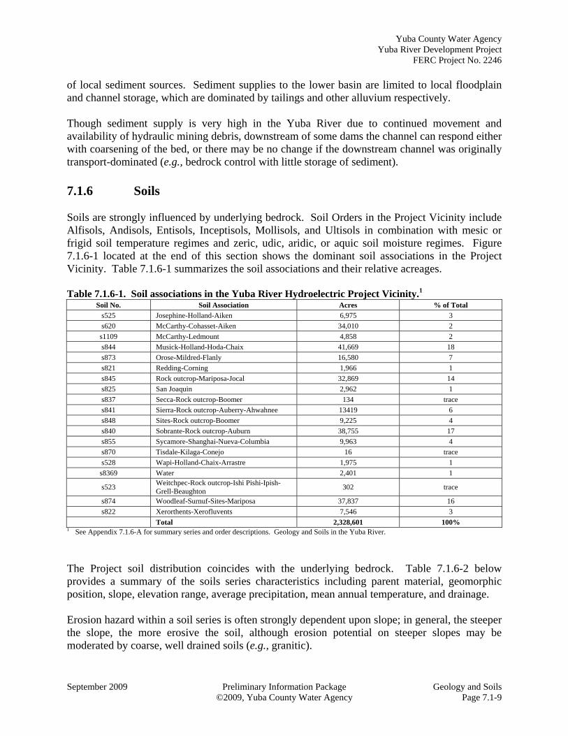
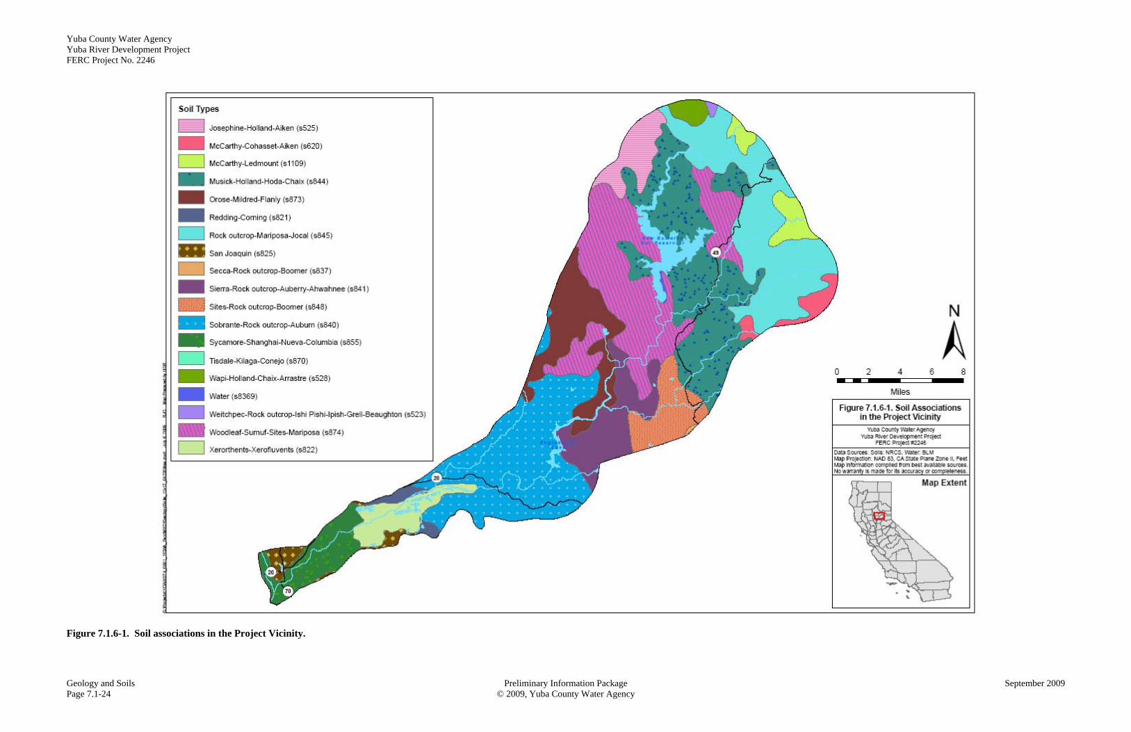
of local sediment sources. Sediment supplies to the lower basin are limited to local floodplain and channel storage, which are dominated by tailings and other alluvium respectively. Though sediment supply is very high in the Yuba River due to continued movement and availability of hydraulic mining debris, downstream of some dams the channel can respond either with coarsening of the bed, or there may be no change if the downstream channel was originally transport-dominated (e.g., bedrock control with little storage of sediment). 7.1.6 Soils Soils are strongly influenced by underlying bedrock. Soil Orders in the Project Vicinity include Alfisols, Andisols, Entisols, Inceptisols, Mollisols, and Ultisols in combination with mesic or frigid soil temperature regimes and zeric, udic, aridic, or aquic soil moisture regimes. Figure 7.1.6-1 located at the end of this section shows the dominant soil associations in the Project Vicinity. Table 7.1.6-1 summarizes the soil associations and their relative acreages. Table 7.1.6-1. Soil associations in the Yuba River Hydroelectric Project Vicinity.1
Soil No. Soil Association Acres % of Total
s525 Josephine-Holland-Aiken 6,975 3
s620 McCarthy-Cohasset-Aiken 34,010 2
s1109 McCarthy-Ledmount 4,858 2
s844 Musick-Holland-Hoda-Chaix 41,669 18
s873 Orose-Mildred-Flanly 16,580 7
s821 Redding-Corning 1,966 1
s845 Rock outcrop-Mariposa-Jocal 32,869 14
s825 San Joaquin 2,962 1
s837 Secca-Rock outcrop-Boomer 134 trace
s841 Sierra-Rock outcrop-Auberry-Ahwahnee 13419 6
s848 Sites-Rock outcrop-Boomer 9,225 4
s840 Sobrante-Rock outcrop-Auburn 38,755 17
s855 Sycamore-Shanghai-Nueva-Columbia 9,963 4
s870 Tisdale-Kilaga-Conejo 16 trace
s528 Wapi-Holland-Chaix-Arrastre 1,975 1
s8369 Water 2,401 1
s523 Weitchpec-Rock outcrop-Ishi Pishi-Ipish-Grell-Beaughton
302 trace
s874 Woodleaf-Surnuf-Sites-Mariposa 37,837 16
s822 Xerorthents-Xerofluvents 7,546 3
Total 2,328,601 100% 1 See Appendix 7.1.6-A for summary series and order descriptions. Geology and Soils in the Yuba River.
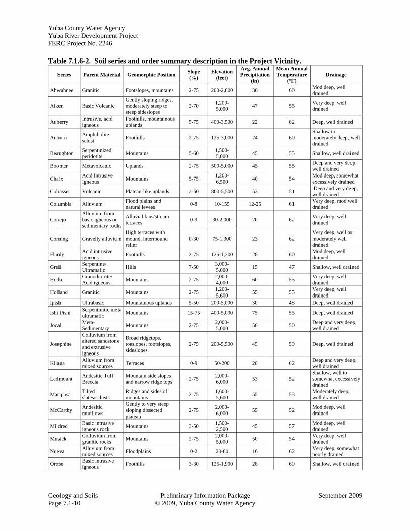
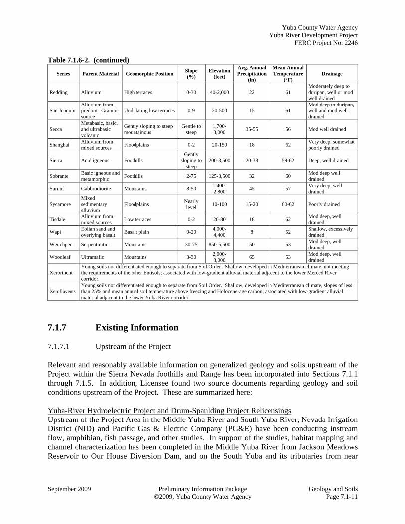
The Project soil distribution coincides with the underlying bedrock. Table 7.1.6-2 below provides a summary of the soils series characteristics including parent material, geomorphic position, slope, elevation range, average precipitation, mean annual temperature, and drainage. Erosion hazard within a soil series is often strongly dependent upon slope; in general, the steeper the slope, the more erosive the soil, although erosion potential on steeper slopes may be moderated by coarse, well drained soils (e.g., granitic).
Yuba County Water Agency Yuba River Development Project FERC Project No. 2246
Geology and Soils Preliminary Information Package September 2009 Page 7.1-10 © 2009, Yuba County Water Agency
Table 7.1.6-2. Soil series and order summary description in the Project Vicinity.
Series Parent Material Geomorphic Position Slope (%)
Elevation (feet)
Avg. Annual Precipitation
(in)
Mean Annual Temperature
(°F) Drainage
Ahwahnee Granitic Footslopes, mountains 2-75 200-2,800 30 60 Mod deep, well drained
Aiken Basic Volcanic Gently sloping ridges, moderately steep to steep sideslopes
2-70 1,200-5,000
47 55 Very deep, well drained
Auberry Intrusive, acid igneous
Foothills, mountainous uplands
5-75 400-3,500 22 62 Deep, well drained
Auburn Amphibolite schist
Foothills 2-75 125-3,000 24 60 Shallow to moderately deep, well drained
Beaughton Serpentinized peridotite
Mountains 5-60 1,500-5,000
45 55 Shallow, well drained
Boomer Metavolcanic Uplands 2-75 500-5,000 45 55 Deep and very deep, well drained
Chaix Acid Intrusive Igneous
Mountains 5-75 1,200-6,500
40 54 Mod deep, somewhat excessively drained
Cohasset Volcanic Plateau-like uplands 2-50 800-5,500 53 51 Deep and very deep, well drained
Columbia Alluvium Flood plains and natural levees
0-8 10-155 12-25 61 Very deep, mod well drained
Conejo Alluvium from basic igneous or sedimentary rocks
Alluvial fans/stream terraces
0-9 30-2,000 20 62 Very deep, well drained
Corning Gravelly alluvium High terraces with mound, intermound relief
0-30 75-1,300 23 62 Very deep, well or moderately well drained
Flanly Acid intrusive igneous
Foothills 2-75 125-1,200 28 60 Mod deep, well drained
Grell Serpentine/ Ultramafic
Hills 7-50 3,000-5,000
15 47 Shallow, well drained
Hoda Granodioirite/ Acid igneous
Mountains 2-75 2,000-4,000
60 55 Very deep, well drained
Holland Granitic Mountains 2-75 1,200-5,600
55 55 Very deep, well drained
Ipish Ultrabasic Mountainous uplands 5-50 200-5,000 30 48 Deep, well drained
Ishi Pishi Serpentinitic meta ultramafic
Mountains 15-75 400-5,000 75 55 Deep, well drained
Jocal Meta-Sedimentary
Mountains 2-75 2,000-5,000
50 50 Deep and very deep, well drained
Josephine
Colluvium from altered sandstone and extrusive igneous
Broad ridgetops, toeslopes, footslopes, sideslopes
2-75 200-5,500 45 50 Deep, well drained
Kilaga Alluvium from mixed sources
Terraces 0-9 50-200 20 62 Deep and very deep, well drained
Ledmount Andesitic Tuff Breccia
Mountain side slopes and narrow ridge tops
2-75 2,000-6,000
53 52 Shallow, well to somewhat excessively drained
Mariposa Tilted slates/schists
Ridges and sides of mountains
2-75 1,600-5,600
55 53 Moderately deep, well drained
McCarthy Andesitic mudflows
Gently to very steep sloping dissected plateau
2-75 2,000-6,000
55 52 Mod deep, well drained
Mildred Basic intrusive igneous rock
Mountains 3-50 1,500-2,500
45 57 Mod deep, well drained
Musick Colluvium from granitic rocks
Mountains 2-75 2,000-5,000
50 54 Very deep, well drained
Nueva Alluvium from mixed sources
Floodplains 0-2 20-80 16 62 Very deep, somewhat poorly drained
Orose Basic intrusive igneous
Foothills 3-30 125-1,900 28 60 Shallow, well drained
Yuba County Water Agency Yuba River Development Project
FERC Project No. 2246
September 2009 Preliminary Information Package Geology and Soils ©2009, Yuba County Water Agency Page 7.1-11
Table 7.1.6-2. (continued)
Series Parent Material Geomorphic Position Slope (%)
Elevation (feet)
Avg. Annual Precipitation
(in)
Mean Annual Temperature
(°F) Drainage
Redding Alluvium High terraces 0-30 40-2,000 22 61 Moderately deep to duripan, well or mod well drained
San Joaquin Alluvium from predom. Granitic source
Undulating low terraces 0-9 20-500 15 61 Mod deep to duripan, well and mod well drained
Secca Metabasic, basic, and ultrabasic volcanic
Gently sloping to steep mountainous
Gentle to steep
1,700-3,000
35-55 56 Mod well drained
Shanghai Alluvium from mixed sources
Floodplains 0-2 20-150 18 62 Very deep, somewhat poorly drained
Sierra Acid igneous Foothills Gently
sloping to steep
200-3,500 20-38 59-62 Deep, well drained
Sobrante Basic igneous and metamorphic
Foothills 2-75 125-3,500 32 60 Mod deep well drained
Surnuf Gabbrodiorite Mountains 8-50 1,400-2,800
45 57 Very deep, well drained
Sycamore Mixed sedimentary alluvium
Floodplains Nearly level
10-100 15-20 60-62 Poorly drained
Tisdale Alluvium from mixed sources
Low terraces 0-2 20-80 18 62 Mod deep, well drained
Wapi Eolian sand and overlying basalt
Basalt plain 0-20 4,000-4,400
8 52 Shallow, excessively drained
Weitchpec Serpentinitic Mountains 30-75 850-5,500 50 53 Mod deep, well drained
Woodleaf Ultramafic Mountains 3-30 2,000-3,000
65 53 Mod deep, well drained
Xerorthent Young soils not differentiated enough to separate from Soil Order. Shallow, developed in Mediterranean climate, not meeting the requirements of the other Entisols; associated with low-gradient alluvial material adjacent to the lower Merced River corridor.
Xerofluvents Young soils not differentiated enough to separate from Soil Order. Shallow, developed in Mediterranean climate, slopes of less than 25% and mean annual soil temperature above freezing and Holocene-age carbon; associated with low-gradient alluvial material adjacent to the lower Yuba River corridor.
7.1.7 Existing Information 7.1.7.1 Upstream of the Project Relevant and reasonably available information on generalized geology and soils upstream of the Project within the Sierra Nevada foothills and Range has been incorporated into Sections 7.1.1 through 7.1.5. In addition, Licensee found two source documents regarding geology and soil conditions upstream of the Project. These are summarized here: Yuba-River Hydroelectric Project and Drum-Spaulding Project Relicensings Upstream of the Project Area in the Middle Yuba River and South Yuba River, Nevada Irrigation District (NID) and Pacific Gas & Electric Company (PG&E) have been conducting instream flow, amphibian, fish passage, and other studies. In support of the studies, habitat mapping and channel characterization has been completed in the Middle Yuba River from Jackson Meadows Reservoir to Our House Diversion Dam, and on the South Yuba and its tributaries from near
Yuba County Water Agency Yuba River Development Project FERC Project No. 2246
Geology and Soils Preliminary Information Package September 2009 Page 7.1-12 © 2009, Yuba County Water Agency
Yuba Gap to Bridgeport. The full text of the Habitat Mapping and Channel Characterization Report is available as a source document on NID’s relicensing website (NID 2009; PG&E 2009). A digital video disk (DVD) with the complete report, including photographs and habitat mapping data, is available from NID and/or PG&E upon request as the size of the data precludes it being posed on the relicensing website. Additional studies being performed in 2009 that relate to geology and soils include: Channel Morphology;
Hydrologic Alteration;
Roads and Trails
Technical memoranda for these study results will be available in late spring 2010. South Feather Power Project Relicensing Slate Creek diversion tunnel transfers water from the Slate Creek diversion dam in the Yuba River basin to Sly Creek reservoir in the Feather River basin (South Feather Power Project, FERC 2088-068). A Final Environmental Impact Statement (FEIS) was completed for this project in 2009 (FERC 2009). 7.1.7.2 In the Project Area In addition to the information used to broadly describe geology and soil conditions in Sections 7.1.1 through 7.1.6, Licensee found four source documents regarding geology and soils conditions in the Project Area. Each of these is described here: Erosion Along Reservoir/Impoundment Shorelines Licensee is unaware of any erosion areas along Project reservoir/impoundments that are not typical of similar reservoirs/impoundments in the Sierra Nevada. Slope Stability Downstream of New Bullards Bar Dam In general, New Bullards Bar Dam is founded on typically hard and strong metavolcanic rock. Much of the rock on the downstream right abutment is fairly massive, and given its typically hard and strong condition it is often only slightly weathered on outcrop surfaces. However, rock within intensely fractured and sheared zones can be weak and highly weathered (Christensen 2007). In early 2006, a rockslide occurred on the slope downstream from the right abutment of New Bullards Bar Dam. The rockslide was initiated as a shallow wedge failure in the steep slope that had been undercut by excavation for the Burma Road. The initial failure occurred during or immediately following several days of intense rainfall, and blocked and damaged the road but did not directly affect Project facilities. Failure by progressive toppling and upslope migration of the developing headscarp and north sidescarp continued through the remainder of the 2005- 2006 rainy season into April, 2006, then ceased entirely. At road level, the slide is 120 feet wide at present and the hazardous area is considered to include the additional 160 - feet long vertical and
Yuba County Water Agency Yuba River Development Project
FERC Project No. 2246
September 2009 Preliminary Information Package Geology and Soils ©2009, Yuba County Water Agency Page 7.1-13
overhanging road cut section of the road on the north. Block toppling and slope raveling may continue to enlarge the slide. A complete report on the geologic conditions contributing to the slide, the mechanisms of failure, the extent and effects of the slide, results of monitoring and recommendations was filed with FERC. Sediment Removal in Our House Diversion Dam Impoundment Sediment has been removed from Our House Diversion Dam on 4 occasions. 1986 – Sediments had been accumulating over 18 years since construction in 1968. The
floods of February 1986 were believed to have contributed the bulk of the sediments. Phase I dredging began sediment removal on August 1, 1986; an unquantified amount was removed. On August 20, 1986, between 7,333 and 15,000 cubic yards was estimated to have been passed downstream through the release valve due to erosion of material in the reservoir, along with an additional unknown amount about a month later. YCWA discontinued removal in the fall of 1986, though an additional 15,000 cubic yards remained to be removed. An interim technical report provided alternatives for additional removal (EBASCO 1986).
1992 - Dredging removed 27,595 cubic yards of sediment between August 3 and September 5, 1992. Sediments were disposed of at a site at the Sierra Mountain Mills approximately 8 miles away (PG&E 1992).
1997 – no report available.
2006 – On December 31, 2005, an intense storm event carried sediments from the upstream reaches of the Middle Yuba River that partially blocked the low level outlet, tunnel intake structure and fishwater release outlet. Dredging removed 80,000 cubic yards of sediment between August 10 and September 15, 2006. Sediments were disposed of in an old quarry site on Marysville Road on USFS land approximately 1 mile south of Bullards Bar Dam (YCWA 2006).
Licensee is in the process of obtaining approval from the appropriate agencies for a sediment pass-through program at Our House Diversion Dam to avoid similar incidences in the future. Licensee is in the process of obtaining approval from the appropriate agencies for a sediment pass-through program at Log Cabin Diversion Dam. Initial Channel Classification upstream of USACE’s Englebright Reservoir An initial channel characterization of the Project reaches was recently developed by the Licensee, using available topographic,5 geologic maps (Saucedo and Wagner 1992), and ESRI/National Agriculture Imagery Program (NAIP) one-meter pixel color aerial imagery ortho-photos from 2005.6 The results of this desktop exercise approximate a Level 1 Rosgen classification (Rosgen 1996), but this exercise is not considered to be such a classification because there has been no field checking; this initial effort used only remote-sensing data. Montgomery and Buffington (1993, 1997; WFPB 1995) classes were used to hypothesize channel form and process, as presented in Table 7.1.7-1. Channels with the same gradient, 5 Derived from Terrain Navigator Pro V.7 available from Maptech, Inc.© 6 http://casil.ucdavis.edu/casil/imageryBaseMapsLandCover/imagery/naip_2005/county_mosaics/
Yuba County Water Agency Yuba River Development Project FERC Project No. 2246
Geology and Soils Preliminary Information Package September 2009 Page 7.1-14 © 2009, Yuba County Water Agency
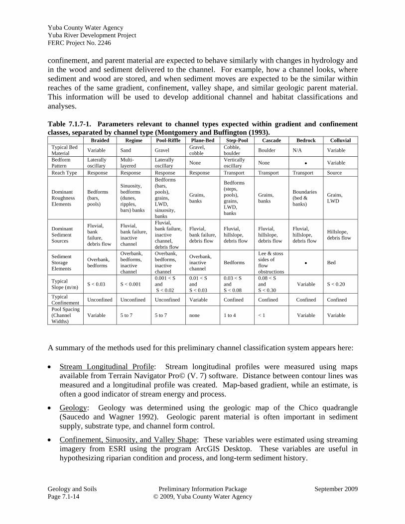
confinement, and parent material are expected to behave similarly with changes in hydrology and in the wood and sediment delivered to the channel. For example, how a channel looks, where sediment and wood are stored, and when sediment moves are expected to be the similar within reaches of the same gradient, confinement, valley shape, and similar geologic parent material. This information will be used to develop additional channel and habitat classifications and analyses. Table 7.1.7-1. Parameters relevant to channel types expected within gradient and confinement classes, separated by channel type (Montgomery and Buffington (1993).
Braided Regime Pool-Riffle Plane-Bed Step-Pool Cascade Bedrock Colluvial Typical Bed Material
Variable Sand Gravel Gravel, cobble
Cobble, boulder
Boulder N/A Variable
Bedform Pattern
Laterally oscillary
Multi-layered
Laterally oscillary
None Vertically oscillary
None Variable
Reach Type Response Response Response Response Transport Transport Transport Source
Dominant Roughness Elements
Bedforms (bars, pools)
Sinuosity, bedforms (dunes, ripples, bars) banks
Bedforms (bars, pools), grains, LWD, sinuosity, banks
Grains, banks
Bedforms (steps, pools), grains, LWD, banks
Grains, banks
Boundaries (bed & banks)
Grains, LWD
Dominant Sediment Sources
Fluvial, bank failure, debris flow
Fluvial, bank failure, inactive channel
Fluvial, bank failure, inactive channel, debris flow
Fluvial, bank failure, debris flow
Fluvial, hillslope, debris flow
Fluvial, hillslope, debris flow
Fluvial, hillslope, debris flow
Hillslope, debris flow
Sediment Storage Elements
Overbank, bedforms
Overbank, bedforms, inactive channel
Overbank, bedforms, inactive channel
Overbank, inactive channel
Bedforms
Lee & stoss sides of flow obstructions
Bed
Typical Slope (m/m)
S < 0.03 S < 0.001 0.001 < S and S < 0.02
0.01 < S and S < 0.03
0.03 < S and S < 0.08
0.08 < S and S < 0.30
Variable S < 0.20
Typical Confinement
Unconfined Unconfined Unconfined Variable Confined Confined Confined Confined
Pool Spacing (Channel Widths)
Variable 5 to 7 5 to 7 none 1 to 4 < 1 Variable Variable
A summary of the methods used for this preliminary channel classification system appears here: Stream Longitudinal Profile: Stream longitudinal profiles were measured using maps
available from Terrain Navigator Pro© (V. 7) software. Distance between contour lines was measured and a longitudinal profile was created. Map-based gradient, while an estimate, is often a good indicator of stream energy and process.
Geology: Geology was determined using the geologic map of the Chico quadrangle (Saucedo and Wagner 1992). Geologic parent material is often important in sediment supply, substrate type, and channel form control.
Confinement, Sinuosity, and Valley Shape: These variables were estimated using streaming imagery from ESRI using the program ArcGIS Desktop. These variables are useful in hypothesizing riparian condition and process, and long-term sediment history.
Yuba County Water Agency Yuba River Development Project
FERC Project No. 2246
September 2009 Preliminary Information Package Geology and Soils ©2009, Yuba County Water Agency Page 7.1-15
Results - Preliminary Classification of Project Reach Channel Types Generally, the Project reaches evaluated appear to be confined within resistant parent material. Gradients are generally greater than 1 percent. Table 7.1.7-2 summarizes the major characteristics of the Project reaches, based on this desktop exercise. Rosgen “Aa+”, “A”, and “B” types are believed to be found within the Project reaches, though some field checking is necessary to confirm this. The applicable Rosgen classes are typified as follows: Rosgen “Aa+”: very steep (>10% gradient), deeply entrenched, debris transport, torrent
streams. Very high relief. Erosional, bedrock or depositional features; debris flow potential. Vertical steps with deep scour or plunge pools and waterfalls.
Rosgen “A”: steep (4-10% gradient), entrenched, cascading step/pool morphology. High energy/debris transport streams with stable plan and profile when bedrock or boulder dominated. Generally exhibit high transport potential and relative low in-channel sediment storage.
Rosgen “B”: moderately steep to gently-sloped (2-4% gradient), moderately entrenched, riffle-dominated channel with infrequently spaced pools. Very stable plan and profile with stable banks.
Rosgen “C”: low-gradient (less than 2%), slightly entrenched, relatively sinuous with pools/riffle morphology, and well-developed floodplains and characteristic point bars. Channel plan and profile stability are dependent upon streambank stability and upstream watershed conditions and sediment regime.
Table 7.1.7-2. Project reach summary.
Project Reach
Length (mi)
Gradient [range]
Confinement Rosgen
Middle Yuba 12.2 1.2%
[1.0-2.9%] confined “B”
Oregon Creek 4.0 2.3%
[0.9-7.4%] confined “A” and “B”
North Yuba 2.3 2.0%
[0.9-5.5%] confined “A” and “B”
Yuba above New Colgate
6.0 1.7%
[0.3-8.0%] confined “B”
Yuba below New Colgate
1.4 <1% confined “C” nearest approx.
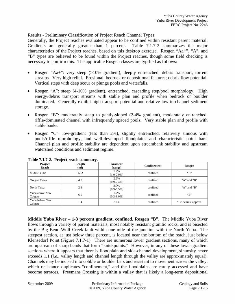
Middle Yuba River – 1-3 percent gradient, confined, Rosgen “B”. The Middle Yuba River flows through a variety of parent materials, most notably resistant granitic rocks, and is bisected by the Big Bend-Wolf Creek fault within one mile of the junction with the North Yuba. The steepest section, at just below three percent, is located near the bottom of the reach, just below Klensedorf Point (Figure 7.1.7-1). There are numerous lower gradient sections, many of which are upstream of sharp bends that form “knickpoints.” However, in any of these lower gradient sections where it appears that there is floodplain and side-channel development, sinuosity never exceeds 1.1 (i.e., valley length and channel length through the valley are approximately equal). Channels may be incised into cobble or boulder bars and resistant to movement across the valley, which resistance duplicates “confinement,” and the floodplains are rarely accessed and have become terraces. Freemans Crossing is within a valley that is likely a long-term depositional
Yuba County Water Agency Yuba River Development Project FERC Project No. 2246
Geology and Soils Preliminary Information Package September 2009 Page 7.1-16 © 2009, Yuba County Water Agency
area and has gradients of about one percent. It may be highly modified by human settlement, and channel location may be defined and maintained by artificial means such as dikes, berms, and hardened or reinforced stream banks. A multi-thread channel splits around an area known as “Emory Island” (~RM 6.5), though sinuosity is still fairly low at 1.1, and gradient is about one percent. Fieldwork would be necessary to further define these areas. Based on the gradient and confinement, expected dominant channel conditions are as follows: Overall channel form: plane-bed
Typical bed material: gravel, cobble
Bedform pattern: none (lacks 3-dimensional heterogeneity)
Reach type: response with short sections of transport
Dominant roughness: substrate, banks
Dominant sediment sources: fluvial (from upstream), bank failures
Sediment storage elements: overbank, inactive channel
Typical slope: between 1 and 3 percent
Typical confinement: variable
1,100
1,200
1,300
1,400
1,500
1,600
1,700
1,800
1,900
2,000
0.00 2.00 4.00 6.00 8.00 10.00 12.00 14.00
Elevation (ft)
River Mile
Middle Yuba Longitudinal Profile
Emory Island
Our House Dam
Junctionw/ North Yuba
Klensedorf Point
FreemansXing/Oregon Ck jnctn/Hwy 49
gradient ‐ 1.2%
Big Bend/Wolf Fault
Geology ‐ volcanic, plutonic granite/granodiorite, undifferentiated metasedimentary
Classification ‐ 1‐3%, confined, Rosgen "B"
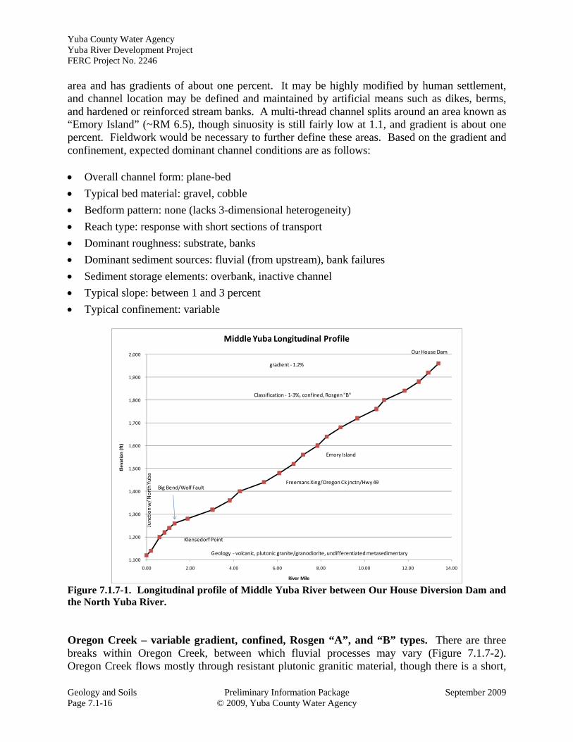
Figure 7.1.7-1. Longitudinal profile of Middle Yuba River between Our House Diversion Dam and the North Yuba River. Oregon Creek – variable gradient, confined, Rosgen “A”, and “B” types. There are three breaks within Oregon Creek, between which fluvial processes may vary (Figure 7.1.7-2). Oregon Creek flows mostly through resistant plutonic granitic material, though there is a short,
Yuba County Water Agency Yuba River Development Project
FERC Project No. 2246
September 2009 Preliminary Information Package Geology and Soils ©2009, Yuba County Water Agency Page 7.1-17
steep section near the top that is composed of competent metasedimentary material. There is a short 4-8 percent gradient section just above the junction with the Middle Yuba River and another one above Celestial Valley. Celestial Valley appears to be a long-term depositional area and has gradients of about one percent. It may have been highly modified by human settlement and channel location may be defined and maintained by artificial means such as dikes, berms, and hardened or reinforced stream banks. Table 7.1.7-3 summarizes likely dominant channel conditions for the two types of channels within the reach (i.e., Rosgen A and B).
1400
1500
1600
1700
1800
1900
2000
0.00 0.50 1.00 1.50 2.00 2.50 3.00 3.50 4.00 4.50
Elevation (ft)
River Mile
Oregon Creek Longitudinal Profile
CelestialValley
Log Cabin Dam
Junctionw/ Middle Yuba
geology ‐ granitic plutons, metasedimentary
gradient ‐ 2.3%
1‐3%, confined, Rosgen "B"
3‐8%, confined, Rosgen "A"
1‐3%, confined, Rosgen "B"
3‐8%, confined, Rosgen "A"
RM0.4
RM0.8
RM 3.6
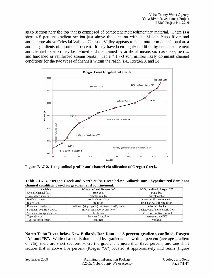
Figure 7.1.7-2. Longitudinal profile and channel classification of Oregon Creek. Table 7.1.7-3. Oregon Creek and North Yuba River below Bullards Bar - hypothesized dominant channel condition based on gradient and confinement.
Variable 3-8%, confined, Rosgen “A” 1-3%, confined, Rosgen “B” Overall channel form step-pool plane-bed Typical bed material cobble, boulder gravel, cobble Bedform pattern vertically oscillary none-low 3D heterogeneity Reach type transport response, w/ some transport Dominant roughness bedforms (steps, pools), substrate, LWD, banks substrate, banks Dominant sediment source fluvial, hillslope, debris flow fluvial, bank failure, debris flow Sediment storage elements bedforms overbank, inactive channel Typical slope between 3 and 8% between 1 and 3% Typical confinement confined variable
North Yuba River below New Bullards Bar Dam – 1-3 percent gradient, confined, Rosgen “A” and “B”. While channel is dominated by gradients below three percent (average gradient of 2%), there are short sections where the gradient is more than three percent, and one short section that is above five percent (Rosgen “A”) located at approximately mid reach (Figure
Yuba County Water Agency Yuba River Development Project FERC Project No. 2246
Geology and Soils Preliminary Information Package September 2009 Page 7.1-18 © 2009, Yuba County Water Agency
7.1.7-3). Just above the steepest section, the gradient flattens to less than one percent. In viewing the NAIP ortho-photos, it appears that the channel has been mostly scoured to bedrock (composed of Mesozoic volcanic rocks of the Smartville Complex), though there are some small inset fine-grained (cobble and smaller) bars on the inside of some bends. The channel is not sinuous, and it appears that the active (scour zone) encompasses the entire valley floor (e.g., there is no apparent floodplain or terrace development). Refer to Table 7.1.7-3 for dominant hypothesized channel conditions within the two channel types of this reach.
1,100
1,200
1,300
1,400
0.00 0.50 1.00 1.50 2.00 2.50 3.00
Elevation (ft)
River Mile
North Yuba Longitudinal Profile
Gaging Station
NewBullards Bar Dam
Junctionw/ Middle Yuba
1‐3%, confined, Rosgen "B"
1‐3%, confined, Rosgen "B"
3‐8%, confined, Rosgen "A"
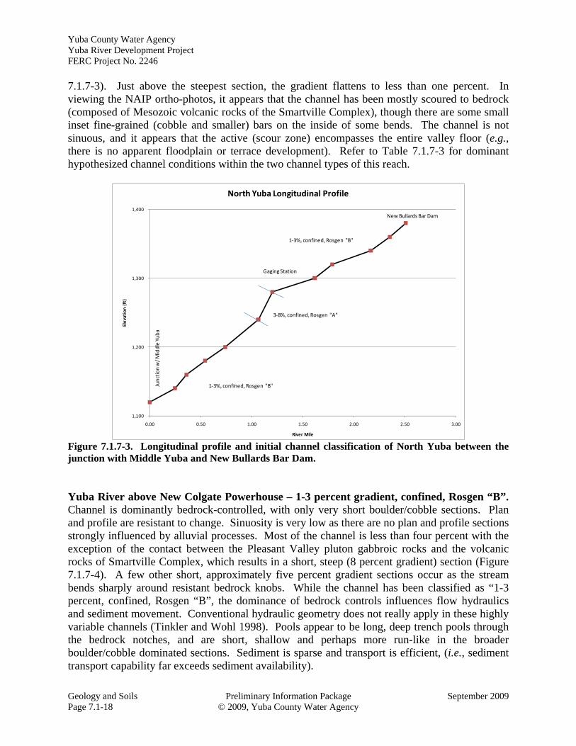
Figure 7.1.7-3. Longitudinal profile and initial channel classification of North Yuba between the junction with Middle Yuba and New Bullards Bar Dam. Yuba River above New Colgate Powerhouse – 1-3 percent gradient, confined, Rosgen “B”. Channel is dominantly bedrock-controlled, with only very short boulder/cobble sections. Plan and profile are resistant to change. Sinuosity is very low as there are no plan and profile sections strongly influenced by alluvial processes. Most of the channel is less than four percent with the exception of the contact between the Pleasant Valley pluton gabbroic rocks and the volcanic rocks of Smartville Complex, which results in a short, steep (8 percent gradient) section (Figure 7.1.7-4). A few other short, approximately five percent gradient sections occur as the stream bends sharply around resistant bedrock knobs. While the channel has been classified as “1-3 percent, confined, Rosgen “B”, the dominance of bedrock controls influences flow hydraulics and sediment movement. Conventional hydraulic geometry does not really apply in these highly variable channels (Tinkler and Wohl 1998). Pools appear to be long, deep trench pools through the bedrock notches, and are short, shallow and perhaps more run-like in the broader boulder/cobble dominated sections. Sediment is sparse and transport is efficient, (i.e., sediment transport capability far exceeds sediment availability).
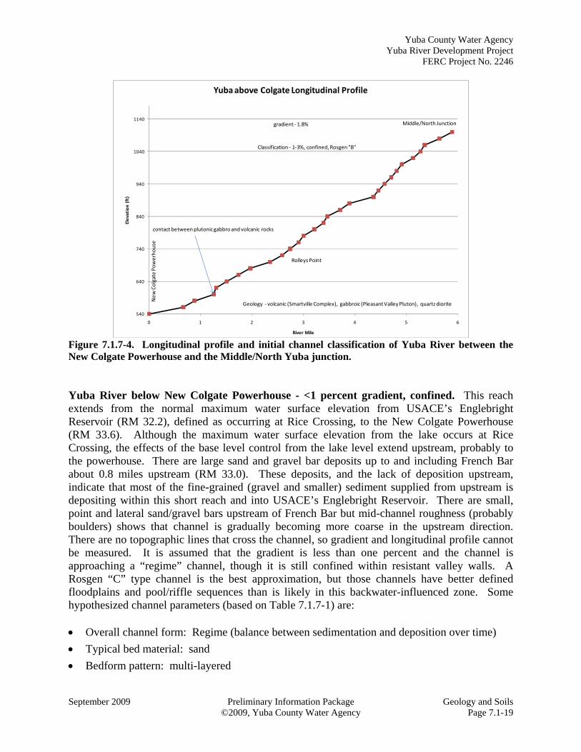
Yuba County Water Agency Yuba River Development Project
FERC Project No. 2246
September 2009 Preliminary Information Package Geology and Soils ©2009, Yuba County Water Agency Page 7.1-19
540
640
740
840
940
1040
1140
0 1 2 3 4 5 6
Elevation (ft)
River Mile
Yuba above Colgate Longitudinal Profile
Middle/North Junction
New Colgate Powerhouse
Rolleys Point
gradient ‐ 1.8%
contact between plutonicgabbro and volcanic rocks
Geology ‐ volcanic (Smartville Complex), gabbroic (Pleasant Valley Pluton), quartz diorite
Classification ‐ 1‐3%, confined, Rosgen "B"
Figure 7.1.7-4. Longitudinal profile and initial channel classification of Yuba River between the New Colgate Powerhouse and the Middle/North Yuba junction. Yuba River below New Colgate Powerhouse - <1 percent gradient, confined. This reach extends from the normal maximum water surface elevation from USACE’s Englebright Reservoir (RM 32.2), defined as occurring at Rice Crossing, to the New Colgate Powerhouse (RM 33.6). Although the maximum water surface elevation from the lake occurs at Rice Crossing, the effects of the base level control from the lake level extend upstream, probably to the powerhouse. There are large sand and gravel bar deposits up to and including French Bar about 0.8 miles upstream (RM 33.0). These deposits, and the lack of deposition upstream, indicate that most of the fine-grained (gravel and smaller) sediment supplied from upstream is depositing within this short reach and into USACE’s Englebright Reservoir. There are small, point and lateral sand/gravel bars upstream of French Bar but mid-channel roughness (probably boulders) shows that channel is gradually becoming more coarse in the upstream direction. There are no topographic lines that cross the channel, so gradient and longitudinal profile cannot be measured. It is assumed that the gradient is less than one percent and the channel is approaching a “regime” channel, though it is still confined within resistant valley walls. A Rosgen “C” type channel is the best approximation, but those channels have better defined floodplains and pool/riffle sequences than is likely in this backwater-influenced zone. Some hypothesized channel parameters (based on Table 7.1.7-1) are: Overall channel form: Regime (balance between sedimentation and deposition over time)
Typical bed material: sand
Bedform pattern: multi-layered
Yuba County Water Agency Yuba River Development Project FERC Project No. 2246
Geology and Soils Preliminary Information Package September 2009 Page 7.1-20 © 2009, Yuba County Water Agency
Reach type: Response with transport sections increasing in the upstream direction
Dominant roughness: sinuosity, bedforms (dunes, ripples, bars), banks
Dominant sediment sources: fluvial (from upstream), bank failures, inactive channel
Sediment storage elements: overbank, bedforms, inactive channel
Typical slope: <1 percent
Typical confinement: unconfined [however, confined in this case] 7.1.7.3 Downstream of the Project Licensee found that significant source documents regarding geology and soils downstream of the Project have been synthesized by EDAW (2006) for the Feather/Yuba Rivers Levee Repair Draft Environmental Impact Report (EIR). Specific groundwater and other characteristics within the Feather River are presented therein. A geomorphic study was performed for the Third Phase of the Sacramento River Bank Protection Project to develop a geomorphically based framework for bank protection evaluation and strategies (WE&T 1991). A studied section of the Yuba River extends from Marysville (RM 0) to USACE’s Daguerre Point Dam (RM 11.4). This section of river is presently a severely aggraded system that has degraded into the mining-derived sediment. A total of 3,500 linear feet of bank protection was mapped as damaged in this section, but the priority for rehabilitation is low relative to sites on the lower Sacramento River and sloughs. In 2008, the SWRCB approved the Yuba River Accord (“Yuba Accord”), a consensus-based, comprehensive program to protect and enhance 24 miles of aquatic habitat in the lower Yuba River, extending from USACE’s Englebright Dam downstream to the river’s confluence with the Feather River near Marysville (YARMT 2009). The Yuba Accord consists of a Fisheries Agreement and several other elements. As part of the Yuba Accord, assessments of physical habitat conditions are being conducted to describe flow and fluvial geomorphological interactions, and to serve as the basis for physical habitat (e.g., reach, mesohabitat unit, flow and temperature) relationships with fish population parameters. To date, morphological units have been mapped on the Timbuctoo Bend on the lower Yuba River using field-based reconnaissance and GIS-based analysis of existing data layers (Pasternak and Eilers 2009; Pasternack 2008). In addition at this same location, digital elevation model differencing was used to quantify flood-induced morphodynamic change (Sawyer et al 2009 in press). As part of this study, pre-and post-May 2005 flood topography mapping was done, cross-sections and velocity data were collected along three transects to validate a two dimensional hydrodymic model, and sedimentary characteristics were visually assessed and mapped (Moir and Pasternack 2008). 7.1.8 List of Attachments None
Yuba County Water Agency Yuba River Development Project
FERC Project No. 2246
September 2009 Preliminary Information Package Geology and Soils © 2009, Yuba County Water Agency Page 7.1-21
Figure 7.1.2-1. Generalized geologic map of the Project Vicinity.
Yuba County Water Agency Yuba River Development Project FERC Project No. 2246
Geology and Soils Preliminary Information Package September 2009 Page 7.1-22 © 2009, Yuba County Water Agency
Figure 7.1.4-1. Active and inactive mines in the Project Vicinity.
Yuba County Water Agency Yuba River Development Project
FERC Project No. 2246
September 2009 Preliminary Information Package Geology and Soils © 2009, Yuba County Water Agency Page 7.1-23
Figure 7.1.5-1. Slopes in the Project Vicinity.
Yuba County Water Agency Yuba River Development Project FERC Project No. 2246
Geology and Soils Preliminary Information Package September 2009 Page 7.1-24 © 2009, Yuba County Water Agency
Figure 7.1.6-1. Soil associations in the Project Vicinity.