Embed Size (px)
Citation preview
CONTENTS
1.0 Introduction 3
2.0 Wood Wharf – existing context 5
3.0 Planning policy considerations 11
4.0 A vision for Wood Wharf 17
5.0 Wood Wharf – an urban framework 19
6.0 A sustainable development 31
7.0 Transport strategy 35
8.0 Development and phasing 39
9.0 Development related requirements 43
10.0 Illustrative proposals 45
11.0 Contacts and further information 49
12.0 Annex 1: Local Planning Policy 51

2
Canary Wharf Millennium Quarter The siteSouth Dock Blackwall Basin

31.0 INTRODUCTION
Wood Wharf lies immediately to the east of Canary Wharf on the Isleof Dogs. It represents one of the few significant sites on the Island yetto be considered for comprehensive redevelopment and provides anopportunity to secure a major mixed-use sustainable development of ascale and quality to both complement Canary Wharf and contribute tothe regeneration of the wider area.
British Waterways, as freeholder of Wood Wharf, has prepared thismasterplan in co-operation with the local authority, the LondonBorough of Tower Hamlets, in recognition of the need for acomprehensive approach to the site’s future re development.
1.1 The role of the masterplanThe purpose of the masterplan is three fold: (i) To determine the development potential of Wood Wharf and
outline the broad development principles that will guide theredevelopment.
(ii) To identify land-use opportunities across the site, the appropriatedensity and massing of buildings, linkages to the surrounding area,
infrastructure, environmental considerations and a phasingschedule.
(iii) To outline the relevant planning framework for the development ofWood Wharf in terms of key planning, transport, environmentaland design issues.
It has been prepared with regard to existing and emergingGovernment guidance, and takes account of the Unitary DevelopmentPlan policies and supplementary planning guidance adopted by theLondon Borough of Tower Hamlets, as well as all relevant materialplanning considerations.
Public ConsultationThe draft masterplan will form the basis of an extensive publicconsultation exercise to obtain the views and opinions of the Isle ofDogs community, property owners and statutory consultees. The viewsof all these relevant groups and communities will be considered indeveloping a definitive masterplan for Wood Wharf. This final versionwill form Supplementary Planning Guidance, which is a materialconsideration when determining applications for developmentproposals on the site.
RI
VE
R
T H A M E S
LON
DO
NB
R
STREET
ON
ROW
LONDONWALL
HOLBORN
THEOBALD'S ROAD
BL
AC
KF
RIA
RS
BR
ID
FAR
RIN
GD
ON
RD
QUEEN VICTORIA STREET
SOUTHWARK
WA
TERLO
OB
RID
GE
VIC
TORI
A
EMBANKMENT
AL
DE
RSG
AT
E
FLEET STREET
CANNON STREET
EASTCHEAP
MO
OR
GA
TE
HOLBORN
TMINSTER BRIDGE
LAMBETHBRIDGE
ALB
ER
TE
MB
AN
KM
EN
TLA
MBE
THPA
LACE
ROA
D
LAMBETH ROAD
KEN
NIN
GTO
NR
OA
D
UNION STREE
ST. GEORGE’S RD
WA
LWO
RT
HR
OA
D
KEN
NIN
GTO
NPA
RK
RO
AD
TOOLEY STREET
LONGLANEG
RE
AT
DO
VERSTREET
STAMFORD STREET
SOU
TH
WA
RK
BR
IDG
E
COM
MERCIAL
ST
RE
ET
LLA
NC
ER
OA
D
MILE END ROAD
COMMERCIAL ROAD
THE HIGHWAY
BUR
DE
TT
RO
AD
CA
NN
ON
ST
RO
AD
EAST INDIA DOCK R OAD
WE
STFE
RR
YR
OA
D
SALTER ROA
D
ABBEY STREET
SOU
TH
W ARK PARK ROAD
MA
NC
HE
ST
ER
RO
AD
AC
KW
ALL
TU
NN
EL
NO
RT
HE
RN
AP
PR
OA
CH
D
OLD
KENT
ROA
DEVELYN STREET
CREEK ROAD
ROTH
ERHITH
E
NEW ROAD
BLACKW
ALL
TUN
NEL
APPRO
ACH
TRAFALGAR ROAD
ALBANY ROAD
Tower Hill
Southwark
Waterloo London Bridge
Limehouse
THECITY
Westferry
West India Quay
Canary Wharf
Heron Quays
South Quay
Crossharbour
Mudchute
Island Gardens
Cutty Sark
Greenwich
Poplar
All Saints
Blackwall
East India
Royal Victoria
BermondseyCanadaWater
Tower Gateway
CanningTown
NorthGreenwich
Bank
Map of London showing location of Wood Wharf.

4 1.2 Opportunities at Wood Wharf Wood Wharf provides the potential to secure significant social,economic and environmental benefits for the Isle of Dogs. It is anopportunity to create a new place to live, to work and to enjoy. Tomaximise this opportunity, any development of the site must seek to:
(i) Secure a sustainable development that provides jobs and homeswithin an attractive urban environment, maximising the use andattraction of the waterfront.
(ii) Create more varied employment opportunities than thosedisplaced by the redevelopment of Wood Wharf.
(iii) Provide a substantial increase in office development, to createa thriving commercial environment.
(iv) Secure significant residential development.
(v) Promote leisure and recreational uses, particularly alongthe quayside.
(vi) Promote travel by public transport and transport modes otherthan the private motor car.
(vii)Develop a community focus and community facilities that areappropriate to the needs of the area.
(viii) Create a new waterspace and secure increased public accessto the waterside.
(ix) Develop new high quality private open space and public realm,which is secure and attractive and will thrive in the long term.
21
CanaryWharf
Traf
alga
r Way
Circle
Cartier
Pres
ton
s R
oad
Churchill Place
Churchill Place
Figure 1: Canary Wharf and the Wood Wharf site.
5
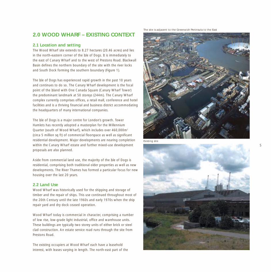
The site is adjacent to the Greenwich Peninsula to the East
2.0 WOOD WHARF – EXISTING CONTEXT
2.1 Location and setting The Wood Wharf site extends to 8.27 hectares (20.46 acres) and liesin the north-eastern corner of the Isle of Dogs. It is immediately tothe east of Canary Wharf and to the west of Prestons Road. BlackwallBasin defines the northern boundary of the site with the river locksand South Dock forming the southern boundary (Figure 1).
The Isle of Dogs has experienced rapid growth in the past 10 yearsand continues to do so. The Canary Wharf development is the focalpoint of the Island with One Canada Square (Canary Wharf Tower)the predominant landmark at 50 storeys (244m). The Canary Wharfcomplex currently comprises offices, a retail mall, conference and hotelfacilities and is a thriving financial and business district accommodatingthe headquarters of many international companies.
The Isle of Dogs is a major centre for London’s growth. TowerHamlets has recently adopted a masterplan for the MillenniumQuarter (south of Wood Wharf), which includes over 460,000m2
(circa 5 million sq ft) of commercial floorspace as well as significantresidential development. Major developments are nearing completionwithin the Canary Wharf estate and further mixed-use developmentproposals are also planned.
Aside from commercial land use, the majority of the Isle of Dogs isresidential, comprising both traditional older properties as well as newdevelopments. The River Thames has formed a particular focus for newhousing over the last 20 years.
2.2 Land Use Wood Wharf was historically used for the shipping and storage oftimber and the repair of ships. This use continued throughout most ofthe 20th Century until the late 1960s and early 1970s when the shiprepair yard and dry dock ceased operation.
Wood Wharf today is commercial in character, comprising a numberof low rise, low-grade light industrial, office and warehouse units.These buildings are typically two storey units of either brick or steelclad construction. An estate service road runs through the site fromPrestons Road.
The existing occupiers at Wood Wharf each have a leaseholdinterest, with leases varying in length. The north-east part of the
Existing site

6
N
RI
VE
RT
HA
ME
S0 500m
IsleofDogs
Superstore
South Quay
BlackwallPoplar
Crossharbour
Mudchute
Island Gardens
HeronQuays
CanaryWharf
West IndiaQuay
CanaryWharf
Existing bus route N50 Existing bus route D6 Existing bus route D7
Site Jubilee Line Existing bus route 330Docklands Light Railway Existing bus route 227
Existing bus route D8 Existing cycle network
Figure 2: Existing public transport accessibility.
7
site at Lovegrove Walk is residential, and lies outside themasterplan area.
2.3 Movement and transport A current assessment of existing transport and traffic movements toand from Wood Wharf indicates that there is little traffic generated bythe existing uses on the site. Few arrivals or departures are on foot orby bicycle and as such there is a heavy dependence on the private car.The site is in close proximity to both the Jubilee Line and DocklandsLight Railway (DLR) stations, however the links to these transportnodes are poor. Figure 2 illustrates existing public transport accessibilityto Wood Wharf.
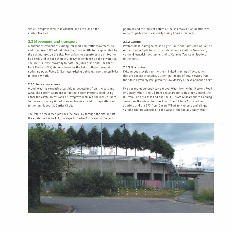
2.3.1 Pedestrian accessWood Wharf is currently accessible to pedestrians from the east andwest. The eastern approach to the site is from Prestons Road, usingeither the estate access road or Lovegrove Walk (via the lock entrance).To the west, Canary Wharf is accessible via a flight of steps attachedto the roundabout at Cartier Circle.
The estate access road provides the only link through the site. Whilstthe estate road is well lit, the steps to Cartier Circle are narrow and
poorly lit and the indirect nature of the link makes it an unattractiveroute for pedestrians, especially during hours of darkness.
2.3.2 CyclingPrestons Road is designated as a Cycle Route and forms part of Route 1of the London Cycle Network, which connects south to Greenwich,via the Greenwich foot tunnel, and to Canning Town and Stratfordto the north.
2.3.3 Bus routesExisting bus provision to the site is limited in terms of destinationsthat are directly accessible. Current patronage of local services fromthe site is extremely low, given the low density of development on site.
Five bus routes currently serve Wood Wharf from either Prestons Roador Canary Wharf. The D6 from Crossharbour to Hackney Central, theD7 from Poplar to Mile End and the 330 from Millharbour to CanningTown pass the site at Prestons Road. The D8 from Crossharbour toStratford and the 277 from Canary Wharf to Highbury and Islingtonvia Mile End are accessible to the west of the site at Canary Wharf.

8 2.3.4 Docklands Light Railway (DLR) servicesThe Docklands Light Railway (DLR) is a high frequency light rail systemthat connects the Docklands with the surrounding local centres andthe City. Wood Wharf is accessible to a number of DLR stations, mostdirectly to Blackwall Station which is approximately a 10-minute walkfrom the site via Poplar Dock. Blackwall lies on the Beckton extensionwith access into Tower Gateway.
Wood Wharf is also within a 12-minute walk of Heron Quay and SouthQuay stations, both of which are due for redevelopment. South Quayis to be upgraded as part of the transport strategy for the MillenniumQuarter development and Heron Quay is to be relocated and rebuilt aspart of the Heron Quay development. These stations are on theLewisham branch of the network, with services operating every 7minutes to Stratford and every 4-5 minutes to Bank.
2.3.5 Jubilee LineThe extension of the Jubilee Line was completed in 1999 to improvecross-London connections and to assist the regeneration of Docklandsand East London. The Jubilee Line operates between Stratford andStanmore and is committed to providing 24 services per hour duringthe peak periods. Canary Wharf station, which is accessible to Wood
Wharf, was provided as part of the Jubilee Line extension and is stillpartly under construction. The station design incorporates two majorsurface entrances of which only the western entrance is currentlyoperational. The eastern entrance, which was due to open in 2002,is within 200 metres of Wood Wharf, although it is separated by theWest India Docks. Presently, access is only available via the indirectlink at Cartier Circle.
2.3.6 HighwaysTraffic flow data for Prestons Road and the site access road, collectedby Transport Consultants as part of an initial Transport ImpactAssessment, indicates a strong flow of vehicles on Prestons Road.It reveals a high southbound flow during the morning peak hourand a high northbound flow during the evening peak hour.
9
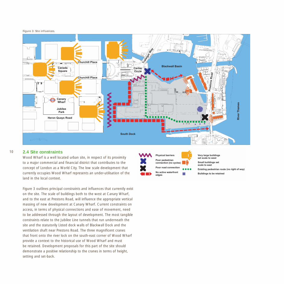
10 2.4 Site constraintsWood Wharf is a well located urban site, in respect of its proximityto a major commercial and financial district that contributes to theconcept of London as a World City. The low scale development thatcurrently occupies Wood Wharf represents an under-utilisation of theland in the local context.
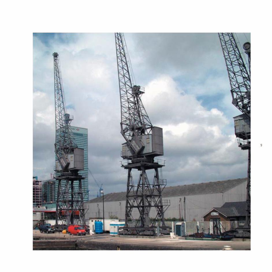
Figure 3 outlines principal constraints and influences that currently existon the site. The scale of buildings both to the west at Canary Wharf,and to the east at Prestons Road, will influence the appropriate verticalmassing of new development at Canary Wharf. Current constraints onaccess, in terms of physical connections and ease of movement, needto be addressed through the layout of development. The most tangibleconstraints relate to the Jubilee Line tunnels that run underneath thesite and the statutorily Listed dock walls of Blackwall Dock and theventilation shaft near Prestons Road. The three magnificent cranesthat front onto the river lock on the south-east corner of Wood Wharfprovide a context to the historical use of Wood Wharf and mustbe retained. Development proposals for this part of the site shoulddemonstrate a positive relationship to the cranes in terms of height,setting and set-back.
Figure 3: Site influences.
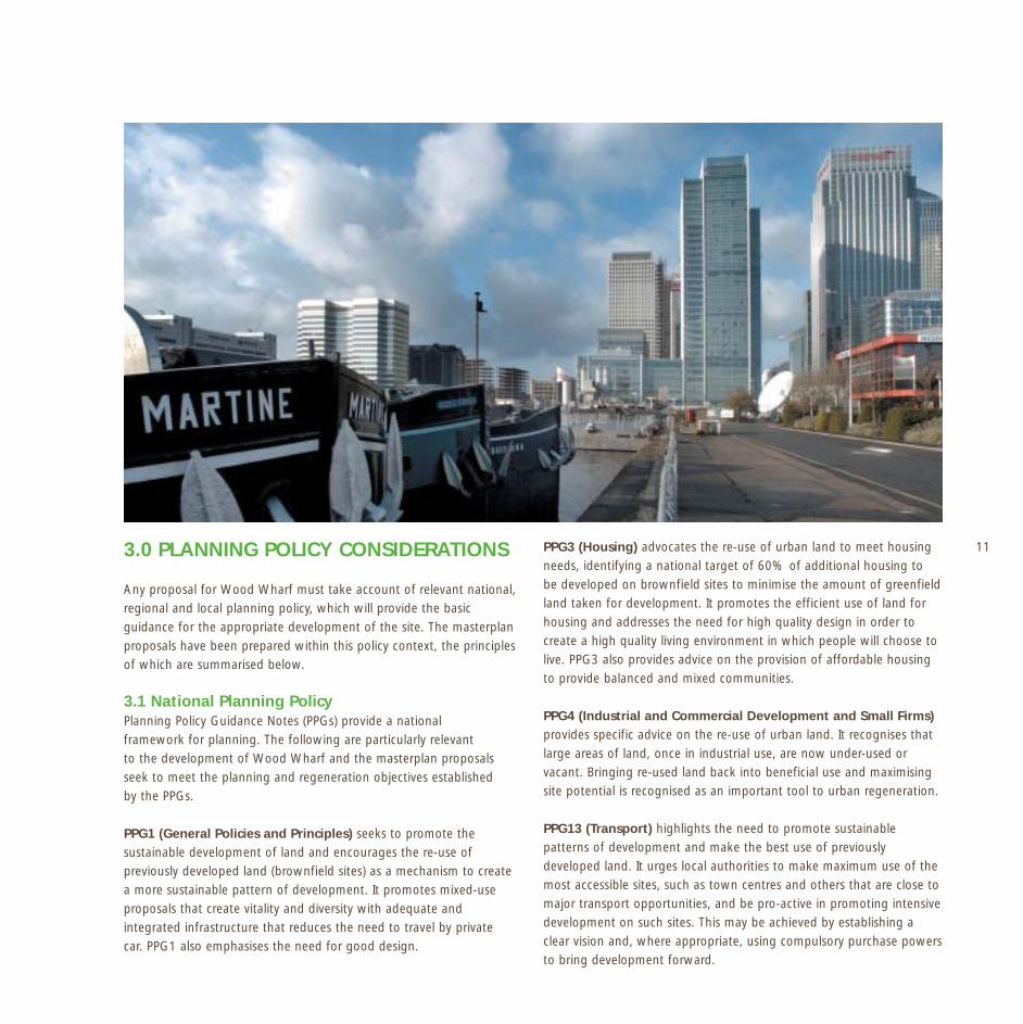
113.0 PLANNING POLICY CONSIDERATIONS
Any proposal for Wood Wharf must take account of relevant national,regional and local planning policy, which will provide the basicguidance for the appropriate development of the site. The masterplanproposals have been prepared within this policy context, the principlesof which are summarised below.
3.1 National Planning PolicyPlanning Policy Guidance Notes (PPGs) provide a nationalframework for planning. The following are particularly relevantto the development of Wood Wharf and the masterplan proposalsseek to meet the planning and regeneration objectives establishedby the PPGs.
PPG1 (General Policies and Principles) seeks to promote thesustainable development of land and encourages the re-use ofpreviously developed land (brownfield sites) as a mechanism to createa more sustainable pattern of development. It promotes mixed-useproposals that create vitality and diversity with adequate andintegrated infrastructure that reduces the need to travel by privatecar. PPG1 also emphasises the need for good design.
PPG3 (Housing) advocates the re-use of urban land to meet housingneeds, identifying a national target of 60% of additional housing tobe developed on brownfield sites to minimise the amount of greenfieldland taken for development. It promotes the efficient use of land forhousing and addresses the need for high quality design in order tocreate a high quality living environment in which people will choose tolive. PPG3 also provides advice on the provision of affordable housingto provide balanced and mixed communities.
PPG4 (Industrial and Commercial Development and Small Firms)provides specific advice on the re-use of urban land. It recognises thatlarge areas of land, once in industrial use, are now under-used orvacant. Bringing re-used land back into beneficial use and maximisingsite potential is recognised as an important tool to urban regeneration.
PPG13 (Transport) highlights the need to promote sustainablepatterns of development and make the best use of previouslydeveloped land. It urges local authorities to make maximum use of themost accessible sites, such as town centres and others that are close tomajor transport opportunities, and be pro-active in promoting intensivedevelopment on such sites. This may be achieved by establishing aclear vision and, where appropriate, using compulsory purchase powersto bring development forward.

12
In essence, PPG13 seeks to reduce car dependency by facilitatingmore walking and cycling and improving linkages by public transportbetween housing, jobs, local services and amenities, principally throughhigh-quality mixed-used development. Sites that are highly accessibleby public transport should be promoted for travel-intensive uses,ensuring the efficient use of land.
3.2 Regional Planning GuidanceRegional planning guidance is contained within Regional PlanningGuidance Notes (RPGs). RPG3 (Strategic Guidance for London PlanningAuthorities) (1996) provides advice for London authorities and istherefore of relevance to Wood Wharf. It provides a frameworkfor the preparation of Unitary Development Plans in London andsuggests ways that London boroughs can contribute to promotingcompetitiveness and regeneration. In respect of Canary Wharf, RPG3states that the area is destined to complement Central Londonand strengthen the Capital’s World City role. The RPG remainsa material consideration in decision making until the adoptionof the new London Plan.
Draft London PlanThe Mayor of London’s Draft London Plan was published in June 2002and establishes a strategic framework for the Capital for the next 15to 20 years. The Draft Plan sets out an integrated social, economic andenvironmental framework for the future development of London andpromotes broad locations for change, which are strongly linked toimprovements in infrastructure.
To achieve these objectives, the Plan advocates that developmentwithin the Capital needs to be undertaken more intensively, withhigher densities and plot ratios on brownfield sites. It recommendsthat the future scale and phasing of development should be integratedwith the capacity of public transport and accessibility of locations.
The Draft Plan establishes spatial priorities for future developmentand growth. It promotes the concept of sub-regions as a mechanismto secure a strategic approach to development in the Capital. The EastLondon sub-region, which incorporates the Isle of Dogs, is the largestwithin London and is identified as a priority area for development,regeneration and infrastructure improvement.
The Draft London Plan identifies a number of “Opportunity Areas”within the East London sub-region, which includes the Isle of Dogs andWood Wharf. Opportunity Areas have been determined on the basis
that they are capable of accommodating substantial new jobs orhomes and their potential should be maximised. The Draft Planprovides a clear vision for the Isle of Dogs as a location for major newhigh-density commercial and residential development to consolidatethe global focus for finance and business that the area has alreadysecured. It identifies the Isle of Dogs Opportunity Area as being ableto accommodate 150,000 new jobs and 3,500 homes by 2016,requiring both adequate land and a significant enhancement totransport capacity.
The achievement of these broad objectives will largely be determinedby the intensity of site development, and the Draft London Planis specific in proposing urban design parameters for new proposals,both commercial and residential. The Plan’s wider remit for theDocklands and Thames Gateway is to establish these areas as locationswhere London can realistically provide the additional capacity for thelarge volume of development needed to attract global institutionsto London and retain them.
Designs on LondonThe London Plan seeks to encourage the maximisation of siteopportunities through the publication of design standards, includingminimum plot ratio and density guidelines.
Plot ratio is a mechanism to assess the development potential of a siteand the London Plan proposes a plot ratio of at least 3:1 where thereis good public transport accessibility and capacity, though within someOpportunity Areas, and particularly the Thames Gateway, it identifiesa ratio of 5:1 as achievable. Factors such as plot ratio will obviouslybe dependent upon the context of development, including built form,character, plot sizes and existing or potential public transport capacity.Further technical advice on appropriate plot ratio is expected from theMayor in due course, and any development at Wood Wharf shouldhave regard to it. Wood Wharf is an obvious key strategic location forsubstantial commercial development. Its accessibility to public transportunderpins the potential for large-scale development, which is capableof sufficient mass to make it a key element of this growing financialand business centre.
For residential development, the Draft London Plan seeks not only toencourage high quality design but also to provide density guidelines,principally related to public transport and other facilities. Thecorrelation that is made in the London Plan between density andaccessibility is key to the ‘proper planning’ of the Isle of Dogs. These

13
principles with regard to both plot ratio and density are representedin the Urban Framework section of this masterplan.
3.3 Local Planning PolicyThe London Borough of Tower Hamlets Unitary Development Plan(UDP) adopted in 1998, sets out local planning policy for the Isleof Dogs area. The function of the UDP is to provide a co-ordinatedframework for the development and use of land in the Borough.Tower Hamlets has recently commenced a review of the Plan andis in the process of preparing further guidance for the Isle of Dogsin the form of a Local Area Framework. Given the early stage ofthis review process, this document is set within the context of theAdopted Plan.
Any development of Wood Wharf must be considered within thecontext of local planning policies, outlined below. A comprehensivelist of these policies and guidance notes is attached at Annex 1of this document.
Planning Policy and Land UseThe greater part of Wood Wharf is not designated for any specific landuse within the adopted UDP, and is currently occupied by commercialpremises. In the north-east corner of the site adjoining Cartier Circlethere is, however, a site-specific proposal for residential development.It is proposed that this site (Jamestown Harbour) is de-designated infavour of the comprehensive approach to a mixed-use developmentoutlined in this masterplan. The area immediately surrounding thesite, including the Canary Wharf development, is however specificallydesignated in the UDP as the Central Area Zone (CAZ). The CAZdesignation recognises the particular character of the Canary Wharfdevelopment and its international status independent from CentralLondon. A balance of Central London core activities of a scale and typecompatible with fostering London’s role as a financial, commercial,tourist and cultural centre, is encouraged within this Zone. The Councilwill support larger developments for business and retail in the formof integrated mixed-use schemes whilst also ensuring that proposalscontribute positively to social vitality and maintain a balance of uses.
Wood Wharf currently lies outside the CAZ boundary, which extendsimmediately around the site to include Blackwall Basin, South Dockand the Canary Wharf estate to the west. The urban design andplanning principles established by the CAZ are, however, embodiedin the proposed development of Wood Wharf. It also reflects recentguidance within the London Plan with regard to mixed-use and the
creation of balanced communities through the inclusion of residentialdevelopment as part of the comprehensive strategy.
Commercial Development and Employment In a policy context, the UDP seeks to encourage a wide range ofeconomic activities within a diversified local economy and promotedevelopment that encourages job opportunities for local people andthe London market (Policies ST15/ST16). Employment growth is clearlyencouraged in the Borough through the re-use of vacant land or theupgrading of sites already in employment use (EMP1).
The loss of sites currently or last used for employment purposes isresisted, unless businesses are replaced with development likely togenerate a reasonable density of jobs in Tower Hamlets, on sites notalready proposed for employment development (EMP2). Access toemployment is a further issue in recognition of a gap within theBorough between the skills held by the unemployed and the jobsavailable. Planning applications will therefore be considered in termsof the extent to which they meet the needs of local people (EMP6).
The development of Wood Wharf will result in the displacementof existing businesses. As such, existing jobs within the site willbe displaced although substantial employment opportunities willresult from the new scheme. Its redevelopment will be of immensesignificance in terms of promoting employment growth andstrengthening the local economy. The UDP already notes that futurelabour demand will be greatest in managerial, professional, technicaland clerical occupations and the redevelopment of Wood Wharf willreflect this trend.
Any planning application for the development of Wood Wharf foran urban mixed-use development must properly consider the issueof employment, in terms of either the possible relocation of existingbusinesses at Wood Wharf or replacement job opportunities. It mustalso consider employment changes within the site in terms of skillsand consider the opportunity for employment training.
Residential DevelopmentThe fundamental precept of the draft Wood Wharf masterplan is amixed-use proposal that accords strongly with the principles of PolicyDEV3 of the UDP, to encourage mixed-use development subjectto general policies and proposals within the Plan. Wood Wharf canaccommodate a significant proportion of residential use, largelyon the eastern part of the site.
14 The inclusion of residential development accords with Policies ST20and HSG2 of the UDP that promote new housing development. Thesite will be developed to a high density (Policy HSG9) and will providea range of units in terms of type, size and affordability in a pleasantenvironment with attractive outlooks over the surrounding waterbodies (HSG7). The masterplan seeks to secure at least 25%affordable housing in accordance with Policies ST23 and HSG3.
Appropriate outdoor amenity space will be provided for residents aswell as public open space (Policy HS16). The provision of supportingcommunity and social infrastructure will also be sought as part of anydevelopment (STR25).
Architecture and MassingThe scale and massing of proposals at Wood Wharf will principallybe determined in accordance with the policies and standards set outin the Adopted UDP. The submission of any planning application forWood Wharf must take account of general design and environmentalpolicies that require development to be sensitive to the character of thesurrounding area in terms of bulk, design, scale and use of materialsand sensitive to the development capabilities of the site (DEV1/DEV2).With regard to massing, Policy DEV6 refers to proposals outside the
boundaries of the Central Area Zone (CAZ) and supports developmentproviding Central London activities subject to the scale and densitybeing appropriate to the surrounding area and not adversely impactingupon it. The intensity of development is broadly measured in terms ofPlot Ratio (DEV1) which provides a general indication of maximumdevelopment appropriate to different parts of the Borough. For WoodWharf, a plot ratio of 2:1 is applied, with a ratio of 5:1 applied toCanary Wharf.
A site-specific analysis of appropriate density and massing as wellas the architectural quality anticipated at Wood Wharf is consideredfurther in Section 5.0 Urban Framework.
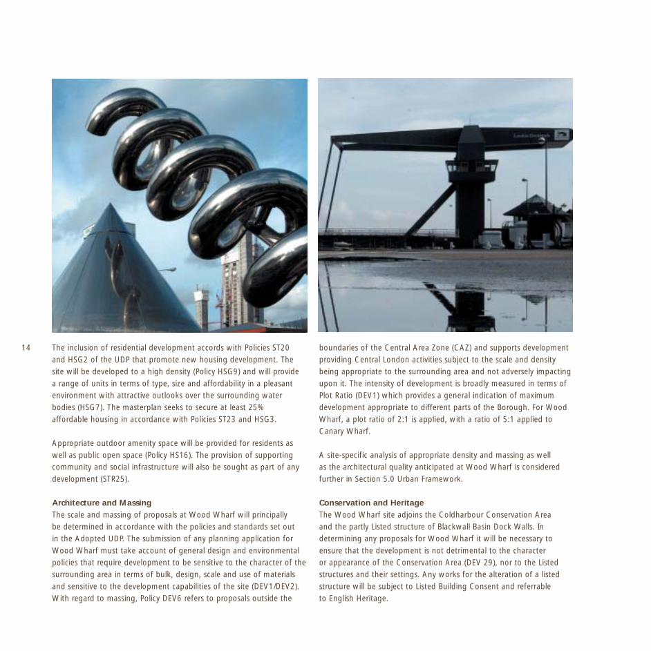
Conservation and HeritageThe Wood Wharf site adjoins the Coldharbour Conservation Areaand the partly Listed structure of Blackwall Basin Dock Walls. Indetermining any proposals for Wood Wharf it will be necessary toensure that the development is not detrimental to the characteror appearance of the Conservation Area (DEV 29), nor to the Listedstructures and their settings. Any works for the alteration of a listedstructure will be subject to Listed Building Consent and referrableto English Heritage.
15Nature Conservation Wood Wharf borders a site of Grade 1 Nature Conservation Importanceat Blackwall Basin and as such, the site’s development must ensure thatit does not cause significant harm to the nature conservation value ofthe Basin, in accordance with Policy DEV57 and DEV47 of the UDP.Moreover, it should aim to enhance the nature conservation of the site(DEV58). Measures to enhance the bio-diversity value of the site areoutlined in Section 6 of this document.
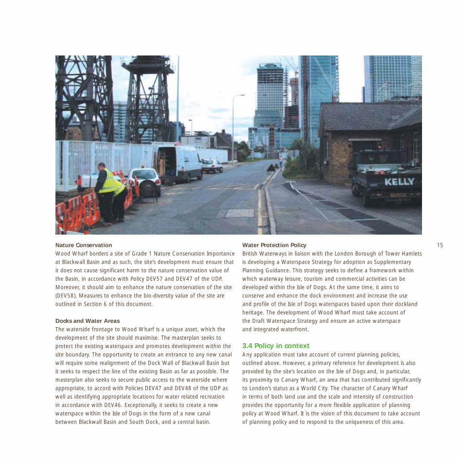
Docks and Water Areas The waterside frontage to Wood Wharf is a unique asset, which thedevelopment of the site should maximise. The masterplan seeks toprotect the existing waterspace and promotes development within thesite boundary. The opportunity to create an entrance to any new canalwill require some realignment of the Dock Wall of Blackwall Basin butit seeks to respect the line of the existing Basin as far as possible. Themasterplan also seeks to secure public access to the waterside whereappropriate, to accord with Policies DEV47 and DEV48 of the UDP aswell as identifying appropriate locations for water related recreationin accordance with DEV46. Exceptionally, it seeks to create a newwaterspace within the Isle of Dogs in the form of a new canalbetween Blackwall Basin and South Dock, and a central basin.
Water Protection PolicyBritish Waterways in liaison with the London Borough of Tower Hamletsis developing a Waterspace Strategy for adoption as SupplementaryPlanning Guidance. This strategy seeks to define a framework withinwhich waterway leisure, tourism and commercial activities can bedeveloped within the Isle of Dogs. At the same time, it aims toconserve and enhance the dock environment and increase the useand profile of the Isle of Dogs waterspaces based upon their docklandheritage. The development of Wood Wharf must take account ofthe Draft Waterspace Strategy and ensure an active waterspaceand integrated waterfront.
3.4 Policy in context Any application must take account of current planning policies,outlined above. However, a primary reference for development is alsoprovided by the site’s location on the Isle of Dogs and, in particular,its proximity to Canary Wharf, an area that has contributed significantlyto London’s status as a World City. The character of Canary Wharfin terms of both land use and the scale and intensity of constructionprovides the opportunity for a more flexible application of planningpolicy at Wood Wharf. It is the vision of this document to take accountof planning policy and to respond to the uniqueness of this area.
16
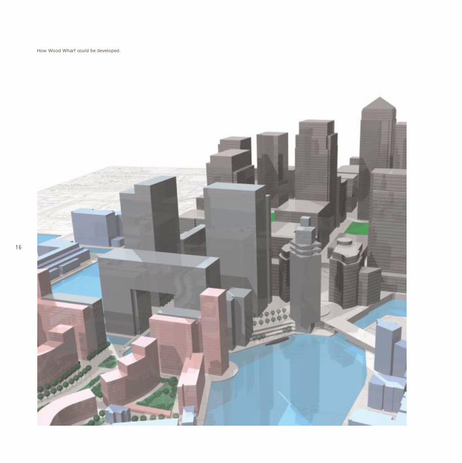
How Wood Wharf could be developed.

174.0 A VISION FOR WOOD WHARF
Wood Wharf is a significant opportunity to deliver a vibrant mixed-usedevelopment and a dynamic new quarter in the Isle of Dogs, creatingthe focus for a new community and providing opportunities andfacilities for both new and existing residents. It will deliver newemployment prospects, create new places to live, stimulate retail andleisure uses and enhance physical links across the Island. Uniquely, thedevelopment of Wood Wharf will create new waterspace and securepublic access to the waterside where it was previously inaccessible,bringing significant regeneration benefits to the wider area.
The development of Wood Wharf will be a sustainable processpromoting excellence in design, both architecturally andenvironmentally.
A PLACE TO WORKCommercial potential: The strategic location of Wood Wharf and itsdirect proximity at its western edge to Canary Wharf represents aunique opportunity to build upon the success of Canary Wharf andcreate a substantial commercial development of new high-quality office
space. Wood Wharf can significantly contribute to providing theadditional employment necessary to confirm the Isle of Dogs as aglobal financial and business centre.
A PLACE TO LIVENew communities: The creation of a mixed-use proposal thatincorporates a substantial element of new housing is fundamentalto the development of Wood Wharf. The site can accommodatea significant level of new homes for East London of mixed tenure,responsive to local housing needs. The proximity to public transportfacilities makes it an ideal location for high-density living, notdependent on car travel.
Community integration: The provision of community facilitiesthat benefit existing residents as well as future occupiers is vital.Facilities may include a crèche, library, health or community centre,depending on local need and viability. The physical integration of localcommunities is also sought through improvements to local pedestrianaccess routes.

18 A PLACE TO ENJOYSocial vitality: The waterfront location of Wood Wharf provides theopportunity to secure vibrant uses at ground floor to enhance themix of living and working spaces and create a dynamic and accessiblewaterside. Leisure activities will be encouraged to utilise the almostcontinuous water-frontage around the site to accommodate a rangeof recreational uses including cafés, bars and restaurants to provideactivity throughout the day and evening.
Accessibility and permeability: The site’s almost continuous water-frontage presents the opportunity to secure landscaped public accessto the dockside, and terraced outside spaces for bars and restaurantsthat will contribute to the vitality of the area. The layout of WoodWharf will incorporate east-west and north-south routes to enhancemovement and linkages across the Island, whilst the construction of apedestrian/cycle bridge linking Wood Wharf to Canary Wharf, soughtas part of the development, will integrate the scheme and ensure goodaccessibility. Significantly, this will improve access for existing residentialcommunities on the east of the Island to the Jubilee Line/DLR and tothe amenities of Canary Wharf.
A PLACE TO VALUEArchitectural quality: Wood Wharf will be a development ofoutstanding architectural merit and design innovation, creatinga unique sense of place whilst respecting the immensity of CanaryWharf and the character of adjoining residential developments.
Environmental quality: The construction and design of Wood Wharfmust address the growing agenda for sustainable design, constructionand lifestyles outlined in Section 6.0 of this framework.

195.0 WOOD WHARF – AN URBAN FRAMEWORK
This draft urban framework outlines the broad principles and designparameters that will guide the future comprehensive developmentof Wood Wharf. It has evolved principally from an assessment of thecontext within which the development will take place and particularlythe characteristics of the surrounding sites in terms of scale, land-use,movement patterns and accessibility.
It establishes development principles with regard to site layout, land-use, building density, building height and desire lines for movementand circulation. It outlines the character and quality of ‘place’ to becreated.
The urban framework also provides a basis to evaluate thedevelopment capacity of Wood Wharf and consider how the visionfor Wood Wharf might be achieved in the long-term. The actualdetermination of site capacity will be subject to the submission ofplanning applications supported by detailed environmental andtransport impact assessments.
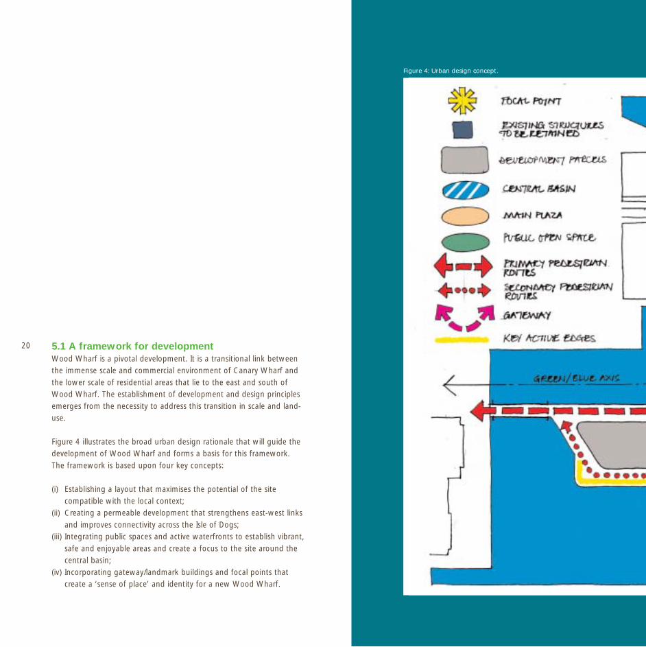
20 5.1 A framework for developmentWood Wharf is a pivotal development. It is a transitional link betweenthe immense scale and commercial environment of Canary Wharf andthe lower scale of residential areas that lie to the east and south ofWood Wharf. The establishment of development and design principlesemerges from the necessity to address this transition in scale and land-use.
Figure 4 illustrates the broad urban design rationale that will guide thedevelopment of Wood Wharf and forms a basis for this framework.The framework is based upon four key concepts:
(i) Establishing a layout that maximises the potential of the sitecompatible with the local context;
(ii) Creating a permeable development that strengthens east-west linksand improves connectivity across the Isle of Dogs;
(iii) Integrating public spaces and active waterfronts to establish vibrant,safe and enjoyable areas and create a focus to the site around thecentral basin;
(iv) Incorporating gateway/landmark buildings and focal points thatcreate a ‘sense of place’ and identity for a new Wood Wharf.
Figure 4: Urban design concept.


22
5.2 Site layoutThree principal factors will determine the layout of developmentat Wood Wharf:
(i) The existing pattern of development in respect of the axial viewsestablished by the grid geometry of development at Canary Wharf
(ii) The proposal to introduce a new canal link at Wood Wharf
(iii) The constraints imposed by the Jubilee Line tunnels (outlinedat Section 2.4)
Axes and alignments The sheer scale and extent of the Canary Wharf estate visiblydominates surrounding developments and it is appropriate thatthe layout of Wood Wharf has regard to it. Canary Wharf is laid outas an orthogonal grid that principally takes its cue from the parallellayout of the original North, Middle and South Docks. This gridpattern is organised around five principal axes, two of which will havea dramatic impact on the organisation of Wood Wharf (Figure 5).
The principal axis (One Canada Square) extends from Westferry Circusthrough the mid-point of One Canada Square and terminates atCartier Circle. As presently conceived, the termination of this axis isunconvincing at Blackwall Basin and effectively “falls off ” the built-upedge of Cartier Circle. The layout of Wood Wharf must exploit thisinfluence and provide the culmination of this axis principally byintroducing a gateway building at the head of the axis.
A second axis runs along the line of Middle Dock, above the JubileeLine, and forms an important landscape element to the Canary WharfEstate. This broad band of landscape runs the entire length of CanaryWharf, alternating between bodies of water (the residue of MiddleDock) and a series of plazas and garden areas. This green axis naturallycontinues into the Wood Wharf site and should form the central publicrecreational space as well as creating a green route from Prestons Roadto Canary Wharf and the public transport interchange.
The grid layout of the Canary Wharf Estate establishes a clear patternof building alignments and a strong building line running east to west.The development of the western section of Wood Wharf should seekto reflect this configuration of development. The influences acting
Figure 5: Plan illustrating principal axes of Canary Wharf. Figure 6: Geometry of layout.

23upon the east of the site, principally the character of the adjoiningresidential areas and the Jubilee Line tunnels, are more varied, whichmay result in a less constrained geometry to its layout (Figure 6).
A new canalA new canal between South Dock and Blackwall Basin will enhancenavigation within the Isle of Dogs. The most appropriate position forthis new link is to continue the line of the northern quayside of SouthDock as it turns northward at the entrance to the river lock. Thisprovides the shortest route and the best visual connection from SouthDock to Blackwall Basin. The canal will effectively divide the site intotwo roughly equal halves, Wood Wharf West and Wood Wharf East,as well as create a central basin and visual focus for new development.
5.3 Land use Figure 7 illustrates the proposed land-use opportunities at WoodWharf. Commercial development will naturally gravitate to WoodWharf West, adjacent to Canary Wharf and closest to the vitaltransport links at the Jubilee Line and DLR stations. This part of thesite should be occupied primarily by business uses within Planning UseClass B1(a) (office), supported by a lively ground level regime of cafés,
bars and restaurants (Use Class A3), together with convenienceshopping (Use Class A1). Both the south-facing quayside overlookingSouth Dock and the Central Basin will be favourable locations for theseuses. There is also potential for an hotel (Use Class C1), subject tomarket conditions.
The eastern half of the site, Wood Wharf East, should be primarilyresidential (Use Class C3), tying in with the existing residential areasat Prestons Road. Some commercial crossover is to be encouragedalong the canal and at the Central Basin, to include office spaceof a different character, such as live-work units. The provision ofcommunity facilities may be located at either Wood Wharf Westor East depending on the nature of the use.
Figure 7: Land use.
24
One Canada Square Flanking 45 storey towers Outer ring 35 storey towers Lower buildings of 16-20 storeys
Figure 8: 3D views illustrating relationship of building heights of Wood Wharf West.
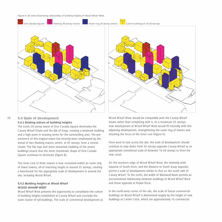
5.4 Scale of development5.4.1 Existing culture of building heights The iconic 50-storey tower of One Canada Square dominates theCanary Wharf Estate and the Isle of Dogs, creating a landmark buildingand a high point in massing terms for the surrounding area. The pre-eminence of this original tower has recently been emphasised by thearrival of two flanking towers, which, at 45 storeys, form a centralcluster. The flat tops and more restrained cladding of the recentbuildings ensure that the more charismatic shape of One CanadaSquare continues to dominate (Figure 8).
This inner core of three towers is now contained within an outer ringof lower towers, all of matching height at around 35 storeys, creatinga benchmark for the appropriate scale of development in around thesite, including Wood Wharf.
5.4.2 Building heights at Wood Wharf WOOD WHARF WEST Wood Wharf West presents the opportunity to consolidate the cultureof building heights established at Canary Wharf and conclude theouter cluster of tall buildings. The scale of commercial development at
Wood Wharf West should be compatible with the Canary WharfEstate rather than competing with it. At a maximum 35 storeys,new development at Wood Wharf West would fit naturally with thisadjoining development, strengthening the outer ring of towers andretaining the focus of the inner core (Figure 9).
From west to east across the site, the scale of development shouldcontinue to step down from 35 storeys opposite Canary Wharf to anappropriate transitional scale of between 16-20 storeys to front thenew canal.
On the southern edge of Wood Wharf West, the relatively wideexpanse of South Dock, and the distance to South Quay opposite,permit a scale of development similar to that on the south side ofCanary Wharf. To the north, the width of Blackwall Basin permits anunconstrained relationship between buildings at Wood Wharf Westand those opposite at Poplar Dock.
In the north-west corner of the site, the scale of future commercialbuildings on Wood Wharf is determined largely by the height of newbuildings at Cartier Circle, which are approximately 16 commercial

25storeys (+ podium). Development at Wood Wharf West must seekto relate to these buildings and secure a more satisfactory completionto the axis at Cartier Circle.
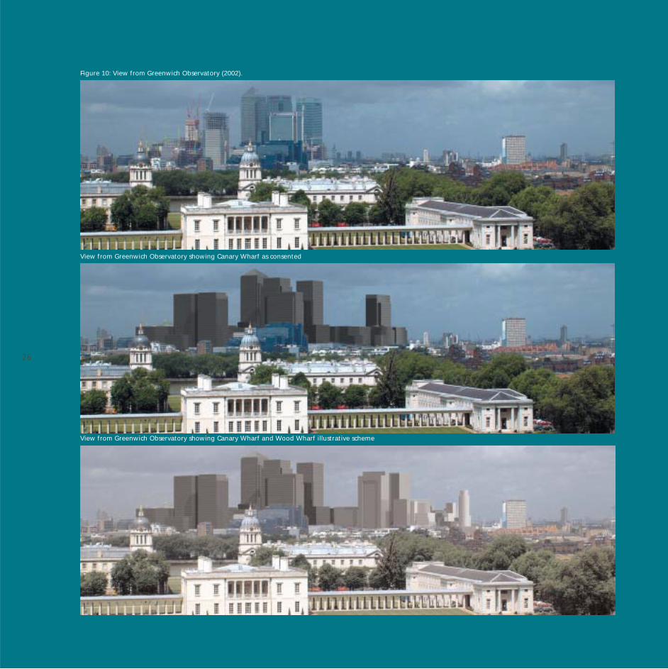
In wider visual terms, as shown from the Greenwich Observatoryviewpoint (Figure 10) any tall buildings on the western part of theWood Wharf site would occupy the same visual space as the BarclaysTower (BP1) as they would lie directly in front of it. The rest of thebuilding blocks at Canary Wharf are lower, being generally half theheight of the outer ring of towers. This is also true of the buildingsproposed at Cartier Circle, which have yet to be built.
WOOD WHARF EAST Immediately to the east of Wood Wharf, the close proximity of existingresidential development of a relatively low rise scale demands asimultaneous reduction in scale at this edge. Residential buildingsproposed for Wood Wharf East should therefore reduce in scale asthey adjoin Prestons Road. With existing adjacent buildings at 4-5storeys with pitched roofs, new buildings should be a maximum of 6-7storeys at this edge. An acceptable transition in scale can be achievedby maintaining the differential between new and existing residentialbuildings to 2-3 storeys at the eastern edge of the site.
At the southern edge of Wood Wharf East, South Dock narrowsto front the locks. The development of Wood Wharf provides theopportunity to mark the entrance to the locks and the egress of theDocks at the south-west corner of the site could be achieved with aresidential landmark tower which should be lower in height than the35 (commercial) storey outer ring, but higher than the eastern edgeof Wood Wharf West (16 commercial storeys). Its function is to makea clear visual marker and landmark. A development of up to 35residential storeys is possible in this respect.
5.4.3 Tall Building AssessmentAny development at Wood Wharf should include the followinginformation to support the submission of a planning application:
Daylight and sunlight: a full assessment of the impact of thedevelopment on the daylight and sunlight of public realm and privateopen space. It is recognised that the scale of development at WoodWharf will result in some impact on normally accepted standards fordaylight and sunlight.
Shadowing: the shadowing impact of tall buildings with particularregard to the adjoining waterspace and dockside.
Micro-climate: The prevailing wind at Wood Wharf is from the south-west. The presence of tall buildings at Canary Wharf and the scaleof the surrounding bodies of water cause abnormal wind patterns,with eddies and downdrafts. It is essential that any application forcomprehensive development at Wood Wharf be accompanied by anassessment of the development in terms of wind turbulence, includingmitigation measures as appropriate.
TV reception: any planning application for all or part of WoodWharf must consider the impact of any proposed development on thetelevision reception of surrounding residential areas and incorporatemeasures to mitigate any negative impacts should it be necessary.
CanaryWharf
Traf
alga
r Way
Circle
Cartier
Pres
ton
s R
oad
Churchill Place
Churchill Place
Figure 9: Building heights
Up to 7 residentialstoreys (21m)
Taller built elementsemphasise focal points
Up to 25 commercialstoreys (100m)
Up to 20 residentialstoreys (60m)
Up to 10 residentialstoreys (30m)
Up to 35 commercialstoreys (140m)
26
View from Greenwich Observatory showing Canary Wharf as consented
View from Greenwich Observatory showing Canary Wharf and Wood Wharf illustrative scheme
Figure 10: View from Greenwich Observatory (2002).

27
5.5 DensityThe concept of tall buildings contributes towards the objectiveof realising the appropriate development potential of the site andestablishing an appropriate density of development. Given the levelof development on the Isle of Dogs, density will largely be determinedby the availability of public transport connections and capacities,evident in the proposed phasing of development at Wood Wharf,outlined in Section 8.0.
The density principles established in the Draft London Plan, outlinedat Section 3.2 on this Framework, provide a guide to the appropriateresidential density of development at Wood Wharf East.
Table 1: Residential Density Guidelines for the Development of WoodWharf (Reference: Greater London Authority Draft London Plan, 2002)
Location Central UrbanVery dense developments, Dense development with
large footprints, all over a mix of different uses and
London and above much buildings. Substantial parts
of central London of inner London
Within 10 minutes 650 – 1100 hr/ha 450-700 hr/ha
walking distance of (mostly flats) 165-275 u/ha
a town centre 240-435 units per h/a
e.g. Canary Wharf
Sites along transport 300-450 hr/ha 200-300 hr/ha
corridors and close 100-150 u/ha FLATS 50-100 u/ha
to town centres
Figure 11 illustrates pedestrian isochrones and public transportaccessibility from Wood Wharf. The western section of Wood WharfEast currently lies within 10 minutes walking distance of the CanaryWharf complex and can, in part, be developed to the recommendeddensities identified in the draft London Plan. The remainder of WoodWharf East is close to the Canary Wharf retail centre and is accessibleto public transport (within 12 minutes of Blackwall, Canary Wharf,Heron Quays and South Quay DLR). Accordingly, it can potentiallybe developed to both central and urban densities.
These figures are provided as a guide. The scale and form of any newbuildings at Wood Wharf, both commercial and residential, will besubject to a detailed appraisal at the planning application stage.
5.6 Plot ratio The objective of plot ratio is to determine the intensity of land use andenable assumptions to be made about the impact of development. Itis not an exact building control but its purpose is to provide a generalindication of maximum development and both the Draft London Planand the Local Unitary Development Plan seek to establish maximumplot ratios (refer to Section 3.2) principally related to good publictransport accessibility and capacity.
Both One Canada Square and more recent schemes at Canary Wharfsignificantly exceed the existing policy guideline of a 5:1 plot ratio,which, given the proximity, provides a reference for Wood Wharf.The urban design analysis of Wood Wharf indicates that it canaccommodate a significant massing of between 7 and 35 storeys,providing a gradient of building heights from Canary Wharf to theresidential scale of the surrounding area. It is appropriate that plotratio similarly varies across the site to reflect the urban context withinwhich Wood Wharf is to be developed.
The scheme developed as part of the masterplan process, illustratedat Section 10, identifies the potential for development at Wood Wharf.
RI
VE
RT
HA
ME
S
IsleofDogs
Superstore
South Quay
PoplarBlackwall
Crossharbour
Mudchute
HeronQuays
CanaryWharf
West IndiaQuay
CanaryWharf
Walking times Site 4 minutes 8 minutes 12 minutes
Figure 11: Walking times and transportation.

28 Whilst not representing an actual development proposal, it does permitan assessment of appropriate plot ratio across the site. Based uponthe illustrative scheme, a plot ratio of approximately 5:1 is achievedon Wood Wharf West, reducing to 2:1 on Wood Wharf East withan overall ratio across the site of 4:1. Any proposal for Wood Wharfmust have regard to this assessment of plot ratio.
5.7 Masterplan design principlesThe prominence of Wood Wharf, in the context of Canary Wharf andthe wider Isle of Dogs, and its significant relationship to the adjoiningwaterspace influences the appropriate development of the site. Anyproposal must have regard to the following design principles to ensurea proper relationship to adjoining land and water.
5.7.1 Landmark BuildingsThe urban design rationale set out at Figure 4 identifies theopportunity to develop landmark buildings within the Wood Wharfdevelopment. The purpose of these buildings is to provide a gatewayto Wood Wharf, to create an identity for the site and contribute to theEast London skyline. They will be determined as landmarks in terms ofbuilding height and exceptional design.
5.7.2 Cartier Circle Cartier Circle lies 7.5 metres above the existing Wood Wharf site level.The development must physically connect to Cartier Circle and reflectthe consented buildings of the Canary Wharf estate to achieve an ‘at-grade’ relationship. To achieve this connection it will be necessaryto build up Wood Wharf West to the level of Cartier Circle to createa podium that will establish a new ground level tie-in with the levelof the Canary Wharf podium (Figure 12).
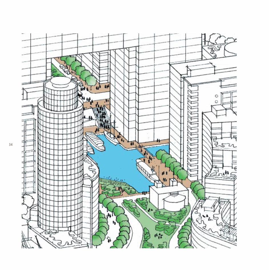
5.7.3 Wood Wharf WaterfrontThe abundance of water frontage at Wood Wharf is an exceptionalresource, which should be fully realised and enjoyed and anydevelopment of the site must seek to maximise the use of this uniquewaterside location. Public access to the waterfront and around the newcentral basin shall be provided around the site where it is practicableto do so. The treatment of the south-facing dockside of Wood Wharfis particularly important. The south-facing quayside at Wood WharfWest will become a prime location for waterfront cafés, bars andrestaurants, and should be terraced and landscaped to provide a variedand interesting edge. Figure 12 illustrates how the interaction betweenland and water could be achieved at South Dock.
Figure 12: Section through Wood Wharf West.

295.7.4 A Vibrant WaterspaceThe waterspace is a unique asset for the Isle of Dogs and focus fordevelopment at Wood Wharf. It is intended that that the bodies ofwater which surround and cross the site will not remain empty andunused, but rather become active spaces which enliven the outlookfrom surrounding buildings.
The development of Wood Wharf should promote the integrated useof the Docks and dockside for leisure, commercial and recreationaluses.
5.7.5 Open space: Public and Private RealmWood Wharf must incorporate a hierarchy of useful outdoor spaces toenhance the local environment and the amenity of the wider area. Therecreational spine formed by the green/blue axis of Middle Dock willcontinue across the Wood Wharf site to create a main body of publicoutdoor space. It is also important that a clear distinction is madebetween public and private space with unambiguous boundaries.
At the centre of Wood Wharf West, the development shouldincorporate a landscaped urban public plaza. This will lead to theproposed new canal basin, which will form the visual hub of the siteand a focus for recreational activity around the water’s edge,incorporating waterside seating areas and pocket parks.
The central landscaped area to Wood Wharf East will take on a muchgreener, more densely planted character of a public park, providing apleasant outlook from the surrounding residential development. Withinthe residential sites, private communal gardens should be created forthe exclusive use of residents. These spaces should be well defined bythe architecture of the development and separated from the publicrealm.
Around the edges of the site, fronting Blackwall Basin and SouthDock, there will be opportunities for further public spaces and hard-landscaped areas of seating looking out onto the water.

30 5.7.6 AccessVehicular access, servicing and parkingSeparate vehicular accesses shall be provided to both Wood WharfWest via Cartier Circle and Wood Wharf East from Prestons Road.This eliminates the need for a vehicular through road, enabling thenew canal link to remain uncluttered by a road bridge and be crossedby pedestrian/cycle bridges only.
Servicing at Wood Wharf can either be ‘top-down’ from the newground level or at quayside level via the service ramp. The heightof the podium to Cartier Circle will allow for generous service areasto the commercial buildings as well as two levels of car parking.
Parking for the residential buildings is likely to be in undercroft or semi-undercroft communal garages.
Pedestrian connections and cycle routesThe redevelopment of Wood Wharf will transform pedestriancirculation in the vicinity. The provision of a new pedestrian bridgefrom Wood Wharf to Canary Wharf Station will be sought as part ofany development to create a direct route from Prestons Road to theheart of the Canary Wharf amenities. The construction of the Podium
at Wood Wharf West will ensure that the new bridge should connect‘at grade’ to Canary Wharf, subject to detailed analysis of clearancesat the Canary Wharf service road.
Wherever possible, the dock sides should be made available for publicfootpaths, which can connect to the existing waterfront walkways andbridges at Blackwall Basin. Cycle paths should be provided within thescheme to connect Canary Wharf and Wood Wharf to the existingcycle network at Prestons Road.
Water taxis It is the water that connects all the new developments aroundthe docks and there is great scope for introducing waterbornetransport such as water taxis as an easy and appealing way ofgetting around, further enhancing the draw of the Isle of Dogs.Wood Wharf should incorporate the potential for water-taxi stopsaround its waterfront perimeter.

6.0 A SUSTAINABLE DEVELOPMENT
Any development of Wood Wharf should address issues ofsustainability and respond to current guidance, as appropriate. Thereare currently no definitive guidelines for sustainable design andconstruction but in the context of London, any developer should haveregard to the Mayor of London’s emerging Energy Strategy, publishedin draft in March 2002. The Strategy embodies the Mayor’scommitment to developing London as a world class city for sustainableenergy. Its aim is to reduce London’s contribution to climate change, toeradicate fuel poverty and promote London’s economic developmentthrough a wide range of renewable and energy efficient technologies.
The Energy Strategy develops a number of key principles to ensure thatnew development is consistent with a sustainable agenda. It seeks toensure that new buildings at least incorporate sustainable design andconstruction techniques wherever feasible to minimise energy demandand maximise use of renewable energy. Enabling more sustainablepatterns of travel will also contribute to this objective.
The development of Wood Wharf should seek to address the Mayor’s
sustainable design and construction agenda and should therefore haveregard to the following initiatives:
Ventilation: Maximum use of controlled natural ventilation in place offorced ventilation in new buildings is encouraged. The Mayor expectsplanning applications referrable to him to incorporate passive solardesign and natural ventilation wherever site conditions make themtechnically feasible.
Photo-voltaic Power: The Draft Energy Strategy acknowledges thatthe technology of photo-voltaics (PV) is widely available, but currentlycostly, so the Mayor will strongly promote their use and hope tostimulate the market and thus reduce costs. The Mayor expects newbuildings of strategic significance (i.e. those referrable to the Mayor),and others considering prestige cladding, to incorporate photo-voltaics(equivalent in cost) where it is technically feasible to do so.Developments not initially incorporating photo-voltaics should be ofsuitable design and orientation to incorporate them later.
Combined Heat and Power (CHP): This is an efficient technology forgenerating electricity and heat in a single process, generally achieving a
31

32 reduction of over 30 per cent in carbon monoxide emissions incomparison with generation from coal fired power stations. The DraftEnergy Strategy determines that the Mayor will expect planningapplications referrable to him to include combined CHP andcommunity heating wherever possible.
Water Recycling: The recycling of roof rainwater (green water) shouldbe considered. Grey water (i.e. wastewater from wash hand basins)could also be used for ablutions and washdown.
Choice of Materials: In considering the detailed design of the futuredevelopment at Wood Wharf, developers should also have regard tothe selection of appropriate materials in addition to an assessmentof product life cycle to minimise replacement. The criteria for selectionshould include the use of non-deleterious materials, i.e. paints thatuse water or other harmless carriers, minimum use of materials thatembody high-energy, e.g. steel and concrete, and sustainablematerials.
Energy use assessment Any developer of Wood Wharf should have regard to the emergingEnergy Strategy and note that the Mayor expects proposers of
developments referrable to him to include an energy use assessment.Developers will be required to demonstrate the steps taken to applythe Mayor’s energy hierarchy, which is meeting essential energy needsthrough:
(i) Applying energy efficiency(ii) Applying renewable energy(iii) Optimising efficiency of energy supply
To contribute to meeting London’s target for the generation ofrenewable energy, the Mayor is also likely to require applications fornew developments of strategic importance to generate a proportionof the site’s electricity or heat needs from renewable sources.
Bio-diversityThe re-development of Wood Wharf provides the scope to enhancethe bio-diversity of the Isle of Dogs and presents habitat opportunitiesfor particular species such as the Black Redstart songbird.
The adjoining Canary Wharf Estate has already implemented theconcept of ‘brown roofs’ and it is proposed that Wood Wharf alsoseeks to provide them where appropriate. The term Brown Roof has
Sou
rce:
Mr
D. G
edg
e, L
on
do
n B
iod
iver
sity
Par
tner
ship
.

33developed as a mitigation response for the loss of brownfield land inLondon, but is effectively a ‘green roof’ or a roof that is intentionallyvegetated. They provide a number of benefits to both the developmentand significantly, to the wider environment in terms of:
(i) Providing a new or replacement habitat that mimics the uniquehabitats of urban brownfield sites;
(ii) Recycling and long term sustainability: brown roofs can beconstructed using substrates and aggregates reclaimed and recycledon site;
(iii) Storm water attenuation: brown roofs can lessen the rapid run-offof water from rain to drain, reducing the likelihood of flashflooding of urban streams and rivers;
(iv) Provision of thermal insulation;(v) Accessible green space: brown roofs can provide many urban
residents and workers with improved access to green/open space.
There is a variety of roofs available and Figure 13 indicates the differenttypes of effect that can be achieved. The Swiss model is determinedto be appropriate to Wood Wharf, a type that has now beenimplemented at a number of locations in London, such as DeptfordCreekside Centre in the London Borough of Lewisham. It is proposed
that any developer seeks to incorporate, to some degree, the conceptof brown roofs within the development.
The roof specification set out below is ideal for Black Redstarts andalso benefits other flora and fauna, such as invertebrates.
• The roof should be based on an aggregate mix from the originalsite, necessitating the use of a mixture of crushed brick andconcrete – 25% of this should be graded material of 50-25mmand 75% should be graded from 25mm to dust. The aggregateshould be thoroughly mixed.
• The roof should be contoured from heights of at least 5cm to 15cm• It should be allowed to colonise naturally.• The roof should consist of material from the site itself and be
allowed to sit on site during construction. This promotes thecolonisation process and will also assist in the recycling of materialsand reduce costs.
The use of Sedum mats (green roof mats) should only be used wherenecessary as they do not benefit wildlife as much as the specificationabove and are generally more expensive.
Figure 13: Example of ‘brown’ roof.
34
357.0 TRANSPORT STRATEGY
The masterplan envisages a major opportunity at Wood Wharf, whichmust be developed in conjunction with the appropriate transportinfrastructure. This section seeks to identify both programmed transportimprovements for East London and the key strategies that are necessaryto support the scale of development anticipated at the site.
A detailed assessment of the impact of the development upon bothexisting public transport infrastructure and planned improvements,undertaken as part of the masterplanning process, indicates that theimplementation of the masterplan will be a phased programme. Thephasing will be determined by the existing and future capacity ofpublic transport as well as physical improvements to the pedestrianaccessibility of Wood Wharf to public transport nodes.
This initial Traffic and Transport Impact Assessment (TIA) that supportsthe masterplan identifies capacity in the existing infrastructure foradditional development in the area, but to support a scheme of thescale proposed for Wood Wharf, improvements to the existingprovision are required. This means that development coming forwardusing the existing capacity may proceed, whilst further development
may only come forward following required improvements and theprovision of additional capacity.
The TIA is based upon a ‘worst-case scenario’ assuming that everyscheme that currently benefits from consent on the Canary WharfEstate and adjoining sites at the Millennium Quarter are implemented.It also takes account of the un-consented proposals at the LondonArena and Canary Riverside 2. Given the long-term nature of theproposals at Wood Wharf and the likelihood that not all consents willbe implemented as presently conceived, any future development atWood Wharf will be subject to a full Transport Impact Assessment.Should these schemes not come forward, there will be additionalcapacity within the system. A full TIA at the planning application stagewill also take account of the major projected changes to transportinfrastructure in East London.
7.1 Programmed transport improvements7.1.1 Jubilee Line capacityAs part of the funding arrangement for the Jubilee Line, LondonUnderground Limited (LUL) gave an undertaking to Canary Wharf toprovide 24 trains per hour in each direction. At the present time, it isoperating at only 18 trains per hour, still below full capacity. Tubelines,

the company responsible for running the Jubilee Line trains, is currentlyreviewing mechanisms to increase the current capacity by 45% byincreasing the frequency of the trains and/or increasing the numberof carriages from 6 to 7. It is also anticipated that improvements to thesignalling equipment would permit an increase in the level of serviceto 30 – 33 trains per hour. This is a longer-term aspiration for LUL thatmay be achieved by 2008.
7.1.2 Docklands Light Railway The DLR is subject to significant expansion proposals. In March 2002,Government issued approval to extend the DLR from Canning Town (onthe Beckton-Tower Gateway route) to London City Airport, with newstations at West Silvertown, Pontoon Dock, London City Airport andKing George V. This is due to open by 2005. The July 2002 Transportand Works Act application by the DLR will extend this route further,crossing the Thames to Woolwich Arsenal. This could be open in 2007.Overall, passenger numbers are increasing by 20% per annum and acomprehensive review of DLR capacity is underway. It is predicted thatthe Lewisham Branch of the DLR will be fully loaded by 2011.
The TIA which accompanies the draft masterplan indicates that there isadditional DLR capacity on the Beckton-Tower Gateway line accessibleto Wood Wharf via Blackwall station. Wood Wharf is therefore ableto maximise the use of existing DLR capacity. Reference to the Mayor’sTransport Strategy shows that the Beckton-Tower Gateway branch willstill have spare capacity in 2011. The Mayor’s Transport Strategy alsoconfirms that Transport for London will bring forward plans for anynecessary increases in capacity.
CrossrailThe proposal for an east-west rail link through London hasbeen discussed for many years in the form of Crossrail. Recentannouncements from the Secretary of State and the Mayor of Londonhave given rise to a certain degree of optimism that a link may beconstructed. Debate is currently underway to decide the route of thelink to the east of Liverpool Street. One option is a connection directlywith Canary Wharf and a potential link to the future developmentareas in the Thames Gateway and Lea Valley, the route now supportedby the Mayor of London. Crossrail would significantly enhancerail capacity to the Isle of Dogs and therefore provide additionaldevelopment potential at Wood Wharf. It would also increase thetransport capacity to Wood Wharf by re-assigning trips, particularlyon the Jubilee Line from the west to the east, thereby releasingcapacity on the more heavily used western corridor.
36 7.2 Transport and Access Strategies for themasterplanPedestrians and cyclistsThe provision of a high-density mixed-use scheme maximises thepotential for local walking trips. The masterplan will seek to securepedestrian friendly areas with high quality pedestrian facilities toinclude routes that are direct and well lit and with buildings designedto provide natural surveillance for improved safety where possible.
A cycle route will be provided through the site, creating an importantnew link in the local cycle network.
Improved pedestrian connections to public transportThe masterplan seeks the provision of a new pedestrian and cyclebridge from the south-west corner of Wood Wharf West to CanaryWharf. This connection will provide future occupiers of the site with adirect link to the public transport interchange at Canary Wharf and theproposed DLR station at Heron Quay and significantly enhance localaccess opportunities in addition to the link from Cartier Circle.
The potential to construct an underground link from Wood Wharf Westto the Jubilee Line station at Canary Wharf has also been considered in

37the course of the masterplan process and initial discussions undertakenwith London Underground Limited. Whilst technically feasible to installa ticket hall beneath Wood Wharf West, providing access via ‘movingwalkways’ to the platforms of Canary Wharf station, this will requirefurther consideration. It is however identified in this masterplan asa desirable option.
Encouraging bus patronageFollowing the publication of the Transport for London study into buslinks on the Isle of Dogs for the Millennium Quarter development,it will be necessary to assess the further improvements that could bemade to the bus network to support the Wood Wharf development.Forecasts have been made as part of the TIA of the number of busesrequired to serve the Wood Wharf development. Assuming a standardsingle-decker bus (as currently operates on the local network), thenumber of additional services required to meet the overall increase indemand for Phases One and Two is 5 or 6 extra buses. It is likely thatin the future there will be a greater shift towards bus usage in EastLondon as the network improves. The development of Wood Wharfwill increase demand for bus travel, and provide the opportunityto develop the local bus network further.
The development of Wood Wharf will also include practical measuresto enhance bus usage. There is an existing bus stop with bus pull-innear the junction of Prestons Road and this should be upgraded withappropriate bus shelter facilities. Bus priority at the Prestons Roadsignalised junction should also be considered. At Wood Wharf West,a new bus stop is proposed at Cartier Circle and this should alsobenefit from a bus pull-in lane.
Highway ImprovementsThe development of Wood Wharf must ensure that the impact onthe surrounding road network is acceptable and that improvementsare made to the road network to accommodate the level of trafficgenerated by the site. In the course of the masterplan process, thetraffic implications of the concept proposals on the surrounding areahave been assessed in respect of traffic generation and capacity of thehighway network. Improvements to the existing road network willbe required to ensure that there is no detrimental impact in terms oftraffic impact. This will include a new signalised junction from PrestonsRoad to the north of the existing access (which will be closed) and anew access from Cartier Circle.

38 Restricted car parking The proposed car parking provision has been restricted in line withgovernment guidance as set out in PPG13, in order to regulate thelevel of resultant traffic generation. Proposed standards for WoodWharf are as follows:
Offices: 1 car space per 880 sq.m.Residential: 0.5 car spaces per dwelling unit
The proximity of the site to public transport and to employment, retailand leisure uses provides the opportunity to include an element of car-free developments within the site.
Increased use of water transportThe development will seek to improve access to water transport modesand incorporate water taxi stops developed as part of the wider Isleof Dogs Waterspace Strategy. The enhanced pedestrian linkagesbetween Wood Wharf and the Canary Wharf estate will alsopromote connectivity to the existing riverbus stop on the westernside of the Isle of Dogs.

398.0 DEVELOPMENT AND PHASING
8.1 Quantum of Development The urban design and massing studies undertaken as part of themasterplan process, together with the preparation of an illustrativescheme of Wood Wharf (attached at Section 10) have served toindicate the level of development that is achievable on the site.The masterplanning exercise indicates that Wood Wharf couldaccommodate at least 460,000 sq m of floorspace (c.5 million sq ft).In terms of land-use allocation this equates to:
Commercial floorspace: 330,000 sq m(including retail/restaurant elements)
Residential: 120,000 sq m (1,500 residential units approx.)
Hotel/serviced apartments 10,000 sq m
8.2 Deliverability and constructionThe comprehensive development of Wood Wharf is a long-termexercise determined principally by changing market pressures and
improvements in transport capacity that are currently scheduled orplanned. This will require a phased approach to construction and theminimum of a four-phase programme is anticipated.
The deliverability of the site in terms of construction will be assistedby the configuration of development parcels that are capable ofproceeding independently. The phasing must ensure that those partsof the site that are not under construction are able to operate withminimal disruption. The programme must also take account of theneed to minimize the impact of construction on the amenity of localresidents by giving consideration to the routing of constructiontraffic, hours of operation, controls over noise and pollution levelsand maintaining, where possible, east-west pedestrian access throughthe site.
8.3 PhasingThe phasing strategy set out in this masterplan seeks to balancethe physical requirements of achieving an appropriate quantumof development with the constraints of the transport infrastructure.It represents one option for unlocking the development potentialof Wood Wharf but is not definitive.

40 The four suggested phases could be adjusted to suit modified buildingsizes, or rearranged to include different combinations within eachphase, provided that the overall floorspace of each phase can beaccommodated within the wider transport infrastructure capacityat the time of its construction.
Phase Commercial Residential Timing Planned or Required Improvements
1&2 Up to 160,000 sq.m c. 1,500 dwellings 2005 • Jubilee Line service• Improve service on the DLR• Improvements to Canary
Wharf Jubilee Line station• Expanded bus network• Improved access junction
3 Up to 260,000 sq m 2011 • Improved service on Jubilee Line to 33 trains per hour
4 Up to 330,000 sq m post-2001 * Crossrail
Table 2: Proposed phasing strategy (cumulative)
The approach is based upon assumptions adopted by DLR and LULconcerning the likely capacity to be available on the transport network,and includes the impact of permitted schemes for Canary Wharf,Millennium Quarter and elsewhere on the Isle of Dogs, in accordancewith the masterplan TIA.
Phases 1 and 2Phases 1 and 2 (Figures 14 and 15) establish the future character ofWood Wharf by securing a significant level of both residential andcommercial floorspace, and the new canal connecting Blackwall Basinto South Dock.
Residential The demands placed upon the transport infrastructure by theresidential element of the scheme are less onerous than those of thecommercial element, and it would be possible to build the entireresidential element as part of Phases 1 and 2. Construction wouldcommence in the north section of Wood Wharf West (Phase 1) withthe southern part of Wood Wharf West constructed as Phase 2.
CommercialThe commercial element in Phase 1 will consist of office buildings thatrelate to Cartier Circle, creating a stand-alone commercial complex.These buildings will relate specifically to those proposed by the CanaryWharf Estate for its sites immediately to the west of Cartier Circle.
Figure 14: Phase 1 Figure 15: Phase 2

41CommunityThe exact nature of new community facilities to be provided as partof the Wood Wharf development will be determined through furtherconsultation with local residents and the Local Authority. It is intended,however, that Phase 1 or Phase 2 include some form of communityprovision.
Phase 1 Approximate FloorspaceOffices 140,000 sq m Residential 50,000 sq m (approx. 600 units)
Phase 2 Approximate Floorspace Offices 15,000 sq m Residential 70,000 sq m (approx. 900 units)
The realisation of Phases 1 and 2 will be determined by on-siteimprovements in accessibility to existing transport nodes: (a) Pedestrian connection between the site and Canary Wharf.(b) New vehicular and pedestrian access to Cartier Circle.(c) Improved vehicular access to Prestons Road.
Off-site improvements will also be sought including: (a) Identifying improvements to the local bus network to connect
to local centres and relieve pressure on the DLR. (b) Exploring in detail the potential for a new escalator at Canary
Wharf Jubilee Line station.
Phase 3Phase 3 (Figure 16) expands the commercial development in the centralsection of Wood Wharf West and establishes the comprehensivenature of the scheme, providing both office space and the opportunityfor leisure facilities around the central basin as well as the potentialto secure hotel provision. Phase 3 will also incorporate the urban publicplaza at the centre of Wood Wharf West, leading to the central basin.
Phase 3 FloorspaceOffices 100,000 sq m
The implementation of Phase 3 will largely be determined by animproved service on the Jubilee Line to 33 trains per hour. This followsthe construction of the pedestrian footbridge in Phase 2 from Wood
Figure 16: Phase 3.
Figure 17: Phase 4.

Wharf West to Canary Wharf which will improve the accessibility of theJubilee Line to the Wood Wharf site.
Phase 4Phase 4 (Figure 17) represents the long term potential of the siteassuming major rail improvements to the Isle of Dogs. Element of thescheme to be constructed in Phase 4 are the office/hotel buildings inthe south west corner of the site.Phase 4 FloorspaceOffices 70 – 75,000 sq m Hotel/office 10,000 sq m
Phase 4 transport improvements include the implementation of newrail infrastructure, possibly Crossrail. Consideration will need to begiven to possible beneficial interim uses for parts of the site priorto them coming forward for development.
8.4 Access during constructionThe provision of a pedestrian access across Wood Wharf, linkingPrestons Road to Canary Wharf, will be maintained in the course of theconstruction programme wherever it is safe and practicable to do so.
8.5 Compulsory purchaseTo facilitate the comprehensive development of Wood Wharf andthe appropriate regeneration of the site, it may be necessary forthe developer to ask the Council to use its powers of CompulsoryPurchase, for example in Section 226 of the Town and CountryPlanning Act 1990 (as amended). The developer will work closelywith all landowners, the Council and other relevant agencies toachieve, as far as possible, a negotiated solution.
The Council will require the developer to provide funding tounderwrite acquisition and all associated costs.
42
439.0 DEVELOPMENT RELATEDREQUIREMENTS
The development of Wood Wharf establishes a new quarter on the Isleof Dogs and new opportunities for work, leisure and homes. It is vitalthat the wider community benefits from the development of the sitethrough both physical improvements to the environment and throughfinancial benefits secured within the scope of any Section 106Agreement, in accordance with the guidance set out in Circular 1/97Planning Obligations.
Development related benefitsThe masterplan promotes the layout of the site to achieve substantialbenefits for the wider community, principally in terms of accessibilityand permeability between the east and west of the site including:
• A new physical link between Wood Wharf West and Canary Wharfvia a new pedestrian/cycle bridge providing direct access to theleisure facilities and transport interchange at Canary Wharf;
• Waterside access: the development of Wood Wharf will open upthe waterside to the community in an area where access waspreviously unavailable through building layout;
• New public spaces on both Wood Wharf East and Wood WharfWest;
• The provision of public art.
Community related benefitsThe inclusion within the scheme of facilities and opportunities thatserve the existing community of the Isle of Dogs as well as futureresidents of Wood Wharf, including:
(i) Employment and Training Benefits: The developer must incorporatea mechanism to provide employment opportunities for localresidents during both the construction and implementation phasesof development. The creation of a Local Labour Exchange in co-ordination with the Local Authority and the Local Labour inConstruction organisation (LLiC) is likely to be sought.
(ii) Safety and Crime Prevention: Any subsequent planning applicationfor the site will need to address how to create a safe environment
44 with the intention of working towards crime prevention. Safety atthe water’s edge must also need to be considered.
(iii) Equality of Opportunity: The London Borough of Tower Hamletshas policies which seek to address the needs of all residents ofthe Borough including those with special needs. Developmentproposals at application stage will need to demonstrate howthe needs of the following are met:• Accessibility for disabled• Environmental improvements• Access to training for all groups• Access to public transport• Mixed use development• Access to public open space and leisure facilities
(iv) Community facilities: It is anticipated that within the development,community facilities such as a health centre, fitness centre, nurseryor children’s play facilities will be provided. The exact nature ofthese facilities will be determined in the course of the communityconsultation.
Financial ContributionsIt is anticipated that financial contributions will be sought as part ofany Section 106 Agreement to provide for the following:
(i) Upgrading of public transport facilities;(ii) Contribution to community facilities such as health centres,
children’s play facilities; (iii) Improvements to the local road network.
Supporting InformationThe submission of any planning application for the comprehensivedevelopment of Wood Wharf must include the following:
(i) Transport Assessment to determine the scope and need for on-siteand off-site highway works as well as contributions to publictransport and pedestrian/cycle facilities. The submission of a GreenTravel Plan is also considered appropriate.
(ii) Environmental Impact Assessment for each phase of development(iii) Design Statement in accordance with advice contained within
PPG1: General Policies and Principles(iv) Tall Building Assessment (v) Accessibility Statement
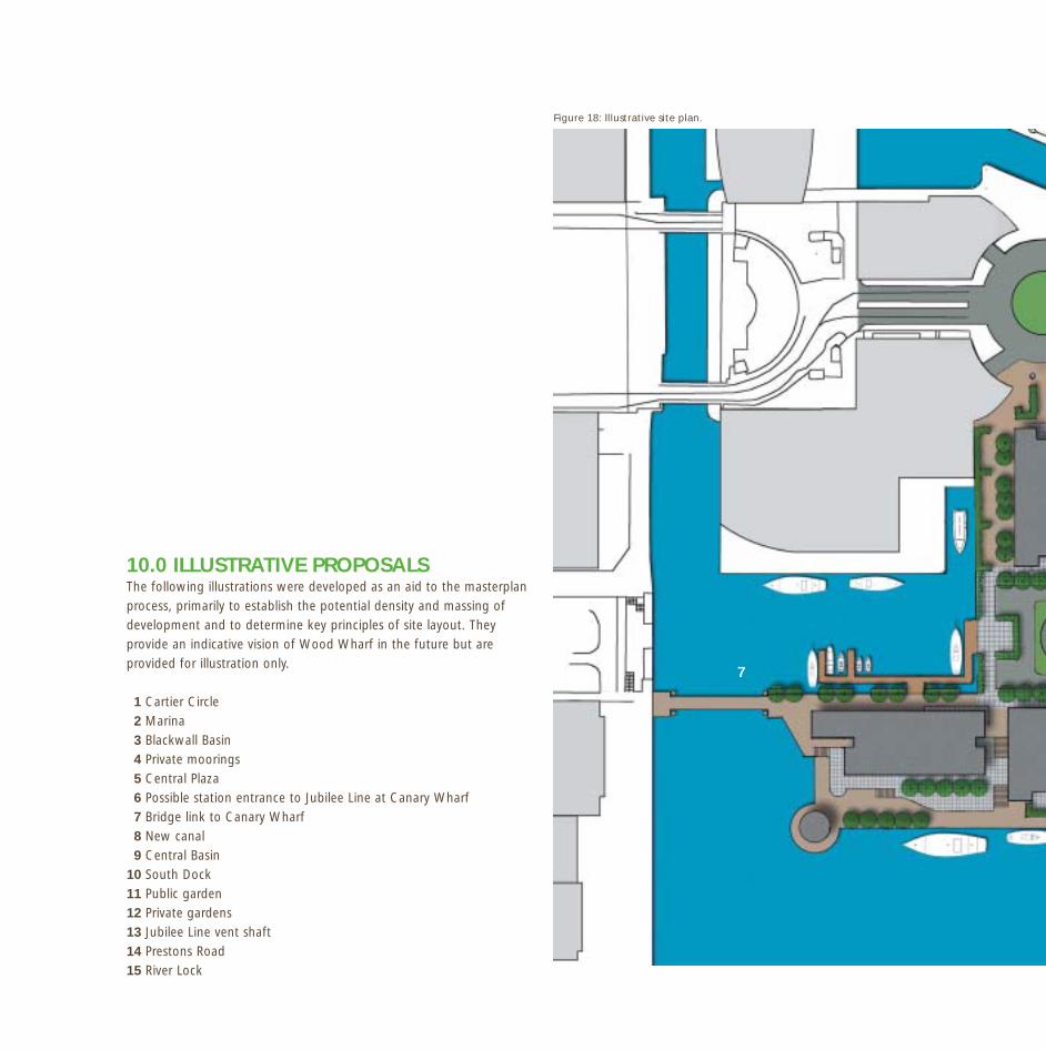
10.0 ILLUSTRATIVE PROPOSALS The following illustrations were developed as an aid to the masterplanprocess, primarily to establish the potential density and massing ofdevelopment and to determine key principles of site layout. Theyprovide an indicative vision of Wood Wharf in the future but areprovided for illustration only.
1 Cartier Circle2 Marina3 Blackwall Basin4 Private moorings5 Central Plaza6 Possible station entrance to Jubilee Line at Canary Wharf7 Bridge link to Canary Wharf8 New canal9 Central Basin
10 South Dock11 Public garden12 Private gardens13 Jubilee Line vent shaft14 Prestons Road15 River Lock
7
Figure 18: Illustrative site plan.

46
13
12
11
12
15
4
3
2
8
8
956
0
14

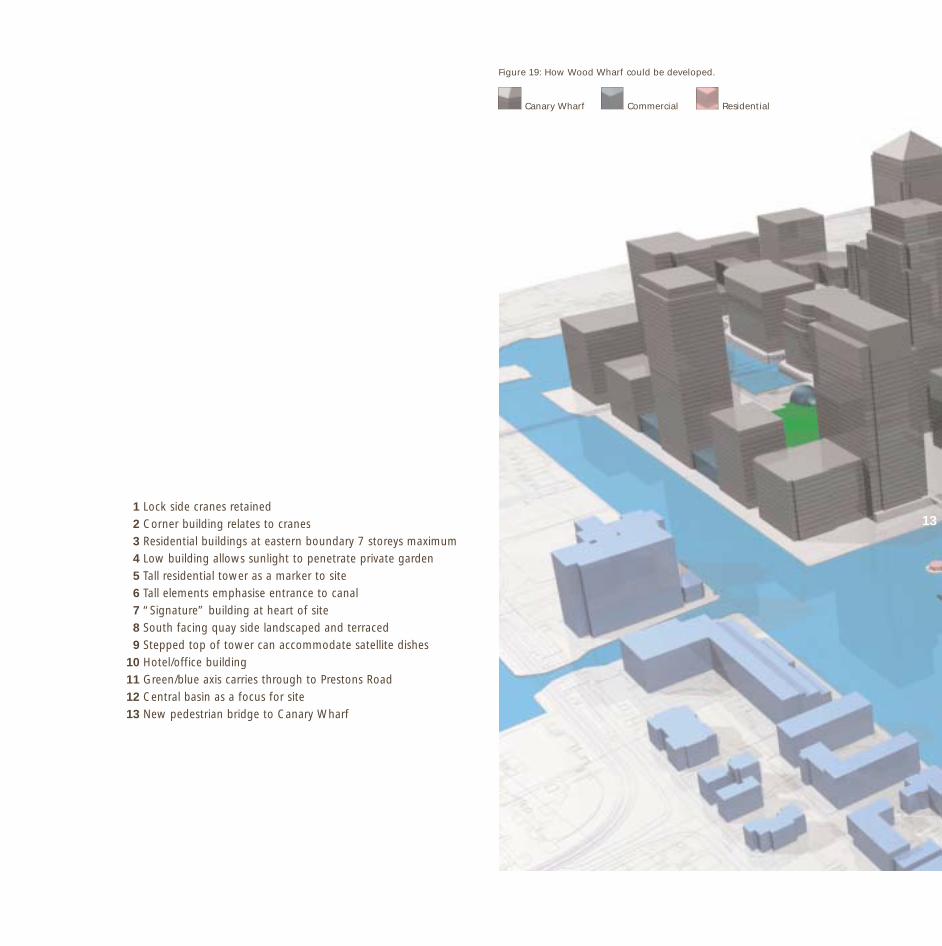
13
Canary Wharf Commercial Residential
1 Lock side cranes retained2 Corner building relates to cranes3 Residential buildings at eastern boundary 7 storeys maximum4 Low building allows sunlight to penetrate private garden5 Tall residential tower as a marker to site6 Tall elements emphasise entrance to canal7 “Signature” building at heart of site8 South facing quay side landscaped and terraced9 Stepped top of tower can accommodate satellite dishes
10 Hotel/office building11 Green/blue axis carries through to Prestons Road12 Central basin as a focus for site13 New pedestrian bridge to Canary Wharf
Figure 19: How Wood Wharf could be developed.

49
9
10
8
86
4
1 2
3
3
5
11
12
7
6

48

4911.0 CONTACTS
For further information regarding the proposed developmentof Wood Wharf please contact:
British WaterwaysLondon RegionThe Toll HouseDelamere Terrace Little VeniceLONDONW2 6ND
Stuart Mills – Regional Commercial ManagerT: 0207 432 8330E: [email protected]
Kate Mansell – Urban PlannerT: 0207 266 6148E: [email protected]
London Borough of Tower HamletsPlanning Department41-47 Bow RoadLONDONE3 2BS
Rodney Keg – Acting Principal (Urban Design/Planning)T: 0207 364 5414E: [email protected]
Supporting Documents:
Transport Strategy for Wood Wharf by WSP (February 2002).

50
5112.0 ANNEX 1: LOCAL PLANNING POLICY
LONDON BOROUGH OF TOWER HAMLETS UNITARY DEVELOPMENT PLAN (ADOPTED 1998)
RELEVANT PLANNING POLICIES
Strategic Planning Policies
ST2: To welcome investment and encourage public/private sectorpartnership proposals which generate employment, improve theenvironment, provide housing and social facilities, and bring derelictsites and buildings into beneficial use, in accordance with the overallstrategy of this plan.
ST3: To promote sustainable development.
ST4: To ensure that development respects the built environmentof the Borough and to encourage development that improves theenvironment.
ST5: To ensure that development contributes to a safe, welcomingand attractive environment that is accessible to all groups of people.
ST7: To promote environmentally acceptable development byencouraging energy efficiency in the design of buildings and theuse of materials.
ST9: To promote and conserve the special character of the RiverThames.
ST10: To protect and further develop London’s role as an international,national and regional centre of commerce, by fostering a range ofappropriate activities.
ST15: To facilitate the expansion and diversification of the localeconomy by encouraging a wide range of economic activities atsuitable locations and the availability of a skilled labour force.
ST16: To encourage development and other measures, which promotejob opportunities for local people and the London job market.
52
ST17: To promote and maintain high quality work environmentsin order to attract investment and maintain the competitivenessof the local economy.
ST19: To seek to ensure that land use and transport policies andinvestment are co-ordinated.
ST20: To ensure that there is sufficient land and buildings availableto meet the Borough’s housing target of 15,000 between 1987and 2006.
ST21: To seek a Borough-wide average of 25% of the housing targetin the form of affordable housing.
ST22: To continue to seek the improvement in the range of housingchoice including affordable housing.
ST23: To ensure that the quality of new housing provided is to a high standard.
ST25: To ensure that new housing developments are adequatelyserviced by social and physical infrastructure and by a public transportprovision.
ST27: To support and improve public transport, ensuring that thesystem is accessible to, and safe for all.
ST28: To restrain the unnecessary use of private cars in order toachieve a more balanced allocation of road space between users.
ST30: To improve safety and convenience of movement for all roadusers, especially pedestrians and cyclists.
ST32: To ensure that development is located so that the transportgenerated can be efficiently, effectively and safely accommodatedwithin the existing and proposed transport system with the minimumdetriment to amenity and the environment.
ST35: To ensure that a reasonable range of local shops is retainedwithin a short walking distance of all residents.
ST37: To improve the physical appearance of the Borough by creatinga more attractive environment for those who live and work here by
maintaining and enhancing the Borough’s parks and other openspaces.
ST39: To ensure participation in recreational facilities is safe andaccessible for all to use and enjoy.
ST47: To encourage and support measures aimed at addressing theskill requirements of the Borough’s residents and businesses throughtraining initiatives.
ST49: To support and encourage the provision of a full range of socialand community facilities in a suitable location to meet the needs of allthe residents of the Borough.
GENERAL POLICY
General Design and Environmental RequirementsDEV1: Development proposals should take account of and be sensitiveto the character of the surrounding area in terms of design, bulk,scale and use of materials. It should be sensitive to the developmentcapabilities of the site and not lead to over-development or poor spacestandards. Development must take account of plot ratio and be visuallyappropriate to its setting as well as provide adequate access fordisabled people and maximise the feeling of safety and security forthose who will use the development.
DEV2: Development should seek to protect amenity, ensure thatadjoining buildings are not adversely affected by loss of privacyor a material deterioration of their daylight and sunlight conditionsand incorporate the principle of sustainable development.
DEV3: Mixed-use development will be generally subject to consideringthe character and function of the area, the scale and nature ofdevelopment and physical constraints of the site.
Planning ObligationsDEV4: The Local Planning Authority will seek to enter into planningobligations with developers that are reasonably related to the scale andnature of proposed development and are necessary for a developmentto proceed.
53
High Buildings and ViewsDEV5: In the Central Area Zone (CAZ) permission may be givenfor high buildings if it satisfies policies DEV1 and DEV2 and theappropriate impact assessments are undertaken and submitted withany proposal (micro-climate, wind turbulence, overshadowing andtelecommunications interference). High buildings must emphasise alocation of civic and visual significance and transport and infrastructuremust be capable of accommodating the level of activity generatedby the development.
DEV6: Outside the CAZ high buildings may be acceptable subjectto considerations of design, siting and the character of the locality.
Landscaping and TreesDEV12 and DEV13: Landscaping will normally required as part of anyscheme with preference given to native tree species as part of anylandscape scheme.
Public ArtDEV18: The voluntary provision of new art within developmentschemes will be encouraged.
Conservation AreasDEV29: Proposals for development adjacent to Conservation Areasshould where possible avoid detriment to the character or appearanceof the Conservation Area and its setting.
Historic Buildings and StructuresDEV36: Development will not normally be granted for the demolitionor partial demolition of any listed building except where a strong casefor demolition exists.
DEV37: Proposals to alter Listed Buildings will be expected to preservethe special architectural or historic interest of the building. Whereappropriate, alterations should seek to retain the original plan formand retain and repair original and external architectural features andwhere possible, replace any missing items and be replaced withtraditional materials.
Riverside DevelopmentDEV46: Water bodies will be protected and promoted for theircontribution to the character of the Borough and as important openareas and the loss of water protection areas will be resisted.
DEV47: New development adjacent to water areas will normally beexpected to conform to the general scale and form of the watersidecharacter and respect important views into and out of the area. Accessto the waterside should be provided where appropriate.
DEV48: New development having a water frontage will be expectedto provide a walkway.
Nature Conservation and EcologyDEV57 and DEV58: Development that unjustifiably causes significantharm to a site of Nature Conservation Importance will not normally bepermitted. Proposals that enhance the nature conservation value willreceive favourable consideration.
CENTRAL AREA ZONES
Developing London’s Regional, National and International RoleCAZ1 and CAZ2: A balance of central London core activities of ascale and type compatible with fostering London’s role as a financial,commercial, tourist and cultural centre will normally be permittedwithin and adjoining the CAZ. The scale and density of developmentmust not adversely impact on the local environment of the amenityof adjoining uses.
Mixed-Use DevelopmentCAZ3: Business and retail developments will be sought as integratedmixed-use schemes, subject to the character and function of the area,scale and nature of development and physical constraints of the site.
THE ECONOMY AND EMPLOYMENT
Promoting Employment GrowthEMP1, EMP2 and EMP6: Employment grown will be promotedthrough the reuse of vacant/derelict land and buildings and theredevelopment of existing employment sites. The loss of employmentgenerating uses will be resisted except where this is replaced withquality buildings at reasonable density; and the need to accountfor how the proposed uses will meet the needs of local people.
Business UseEMP9 and EMP10: The CAZ is designated as an area for businessgrowth favourable for Class B1 use; outside CAZ development forbusiness uses will be permitted where premises provide adequate

54
loading and servicing facilities, it would not create unacceptable trafficlevels and is well served by public transport.
HOUSING
New Housing DevelopmentsHSG2: New housing will be permitted on non-residential/ vacant siteswhere land is not required for other uses, the environment is suitablefor residential use and there are adequate services in the locality.
Affordable HousingHSG3: The Council will seek the provision of at least 25% affordablehousing on all residential development with a capacity of 15 dwellingsor more. This provision should be developed on site.
Dwelling Mix and TypeHSG7: New housing developments should provide a mix of unit size,including family dwellings on schemes of 30 or more units.
DensityHSG9: Guidelines are set out for family dwellings and higher densitydevelopment where this provides affordable housing, has easy accessto public transport, are part of a mixed use scheme and meets otherhousing standards.
Amenity SpaceHSG16: All new developments should include adequate amenity space.
TRANSPORT
Rail and Underground ServicesT1: Improvements/extensions to rail and underground services aresupported.
Bus ServicesT3: The provision of additional bus services in areas that are poorlyserved will be encouraged.
Taxis and Mini CabsT6: Facilities to support the role of taxis are encouraged.
Strategic Traffic ManagementT9 and T10: To discourage non-essential journeys by private car; traffic
management and restraint proposals must take account of roadsafety for all users, access for emergency services, operation of publictransport and needs of local businesses, pedestrians, shoppers, cyclists,access for disabled and statutory undertakers and on street parking.
Transport and DevelopmentT15 and T16: Proposals assessed in relation to the ability of theexisting and proposed transport system to accommodate additionaltraffic generated and the operational requirements of the proposeduse, and impact of traffic generated.
PedestriansT19 and T20: Measures to improve the quality, safety and conveniencefor pedestrians; support for pedestrian facilities along canals andriversides.
CyclistsT22 and T23: The introduction of cycle routes and safety andconvenience of cyclists is a priority in design and implementationof traffic management measures.
OPEN SPACE, LEISURE AND RECREATION
Local open spaceOS2: The improvement of the quality of access to and within parksand open spaces for people with disabilities is encourage.
Children’s play spaceOS9: A wide range of play facilities should be made available, wherethere is a high density, high concentration of homes without gardens,poor environmental conditions and major roads of other physicalbarriers limit accessibility.
ARTS, ENTERTAINMENT AND TOURISM
Mixed-use developmentsART5: The provision of facilities that sustain, enhance or develop artsand entertainment facilities is encouraged through planning briefs andvoluntary contributions.