Embed Size (px)
Citation preview

ECONOMIC AND GENERAL GEOLOGY. 117
7RS_ //7- I\J6 THE IRON CLIFFS MINE, PENGUIN
by K. L. Burns
I. INTRODUCTION The Iron Cliffs Mine, including the "Lady Braddon" and
., Badger" Mines, is a group of exploratory workings in and around a large outcrop of limonite near Penguin. on the north-west coast.
The area has been investigated by several syndicates seeking a sulphide orebody beneath the limonite, but the workings were shallow and reached no greater depth than the natural exposures.
In the summer of 1959-60, two exploratory drill holes were put down to obtain a cross-section of the orebody at depth, In this. report the first-order proflle of the orebody is deduced, incorporating the drilling results.
II. TOPOGRAPHY. SITUATION The area lies six miles S.S.W. of Penguin. in the ravine of
McBrides Creek about half a mile upstream of its junction with Penguin Creek. The mines are within the .. Femdene" Scenic Reserve, about 10 minutes walk upstream from the car park.
The maps appended were surveyed with chain, compass and abney level as no staff-man was available. The local grid on the maps has as datum a small ledge at the southern end of the H small iron cliff ", shown as 1000EI000N (feet) 300 a.s.l. local grid. This is close to 40312E93216N (yards) 300 a .s.l. on the state Grid.
III. PREVIOUS LITERATURE Although frequently mentioned in the literature, only three
previous examinations of the area have been made, by Montgomery" (1896. p. Ix); Harcourt-Smith (1899. p. x) and Twe1vetrees (1903. pp. 14-15>.

A
w
'<tON ORE.
LAMSRIAN
OUNDAS GROuP - MUDS"ONE S
PR£(AMBIUAN
~,O~~~O~~PE. GROUP -&. SANOSTON ES
0 . 0 . 1
IRON CLIFFS COMPOSITE PROFILE
5cm
B
K. L. BURNS GEOLOGIST ·
1980 . .
2S0'
.... .... 00

ECONOMIC AND GENERAL GEOLOGY. 119
IV. GENERAL GEOLOGY The area lies at the western foot of Mt. Dial, composed of the
Ordovician Dial Conglomerate. The base of the conglomerate occurs several hundred feet above the mine area, concealed by extensive scree, but is exposed about a mile south in McBrides Creek.
A north-trending belt of iron ore, mainly limonite, dominates t he mine area, the edge of the outcrop often marked by "iron cliffs". The outcrop is as little as 10 feet wide in the southern part of the area, expanding to almost 500 feet wide at the "northern extension". The orebody is vertical or dips steeply east.
West of the iron ore are mudstones and sandstones, with possibly clay pellet conglomerates, assigned to the Rocky Cape Group (pre-Middle Cambrian). These rocks extend down McBrides and Penguin Creeks, forming the host rock for the haematite iron ores of Penguin Creek, one mile to the north-east. and also form the host rocks at the Blythe Iron Mines, five miles west-south-west.
East of the limonite are greywacke boulder beds. conglomerates, sandstones and siltstones. and felspathic and carbonaceous rocks, correlated lithologically with the Dundas Group (Middle-Upper Cambrian). On general grounds these rocks probably belong to the highest part of the Dundas succession of the Dial Range.
The contact between the Dundas and Rocky Cape Groups lies just east of the eastern boundary of the iron ore, and is exposed. about six feet from the end of No. 2 tunnel, and was intersected in the second drill hole.
The hilltops around the mine are covered with a Tertiary sand and gravel bed derived from the Dial Conglomerate, overlain by Tertiary basal t .
The slopes in the mine area are mantled with debris from all t he rock types mentioned. outcrops forming only about one per cent of the area, and occuning as free faces in thick scree lying near its angle of rest. So poor is the outcrop that prior to artificial exposure, Montgomery presumed the host rocks to be horizontal Dial Conglomerate.
V. THE MINE PROPERTIES In 1896 Montgomery visited the area and recommended explora
t ion. Harcourt-Smith, in 1898, found leases 1785-93M (78 ac.) 1661-93M (79 ac.) in force, and Mr. Ellis had driven tunnels 2. 4 and 7 (?). A quantity of iron ore had been shipped (Twelvetrees and Reid, p. 45) but was unsuitable for the high grade market sought.
After this, the Lady Braddon (Development?) Company wa$ formed to drive tunnel 1. At about the same time Badger and Hall, holding lease 4849-93M, drove tunnels 5 and 6 at the Badgers Mine.
In 1903 Twelvetrees found the Iron Cliffs held under lease· 340-M by Hutton and Revell. Open cutting was proceeding at the .. northern extension", at 1700E2400N. The old Badgers Mine was then held by McKenna and Rogers under lease 707-M, adjoining 340-M.
Thus this small area appears in the records as the Iron Cliffs, Badgers Mine, or Lady Braddon, but will be considered as a whole_

120 ECONOMIC AND GENERAL GEOLOCY.
VI. MINE W ORKINGS Underground exposures are not well preserved. Blankets of
ferruginous clay and fiowstone have obscured the walls, and collapses and flooding make most tunnels unsafe. There is dimculty in identifying some of the tunnels described by early writers, but the following synthesis is probably correct.
Tunnel No.1 Tunnel No.1 is the Lady Braddon Tunnel. driven by the Company
after 1898. Hutton and Revell extended the tunnel another 90 feet by 1903. at which time the tunnel was 290 feet long. driven north-east at creek level. It passed through soft slates. sandstones and clay I with bands of ironstone. The last 37 feet was in .. clay ironstone gossan" with blebs and veinlets of silica (analysis T4) . This tunnel is now blocked by a collapse 50 feet from the entrance. in mudstone.
Tunnel No.2 Tunnel No.2 was driven by Ellis between 1896 and 1898. Since
then the tunnel has been extended a further 12 feet. and a shaft sunk 25 feet on the edge of the iron ore. Twelvetrees says this tunnel was driven following high gold assays of the outcrop. HarcourtSmith says the lode is friable. porous gossan with quartz veins and not much copper, silver or gold.
Tunnel No.3 Tunnel No. 3 is a shallow tunnel driven in decomposed con
glomerate, containing a narrow band of sericitised felspathic sandstone 78 teet from the portal.
Tunnel No ... Tunnel No. 4 was recorded by Harcourt-Smith as 50 feet long
through "brecciated conglomerate ", with green copper stainings on the walls, while a vein at rubbly Quartz at the entrance contained native copper. Since then the tunnel has been extended to 70 feet, still in decomposed. structureless conglomerate.
'Tunnel No. 5 Tunnel No.5. Twelvetrees says this t unnel begins in decomposed
Quartz-felspar porphyry. It cuts a vein one half to two inches wide, then follows the lode in slate country. At 55 feet crosscuts were put in both ways, and a little native copper found in the north cuddy. A small shaft was sunk 24 feet in galena veins. Three small stapes recovered three tons of galena containing half an ounce of silver per unit of lead. This tunnel is waist deep in slime (full when discovered) , with the lode exposed on the roof as a narrow fault zone with chloritic gouge. No galena was observed, but pyrite occurs dotted along the bedding of greywacke sandstone in the south cuddy. The stapes have collapsed 73 feet from the portal.
Tunnel No.6 Tunnel No. 6 is now inaccessible, but was described by Twelve
trees as 400 feet long, and as having yielded an are of zinc blende, chalcopyrite and pyrite. Assays returned 44% lead and 13 ounces of silver, per ton.

I:rj
E'l e " l"l I):)
:x'
Scm
IRON CLIFFS AREA AROUND D.D. HOLE 2.
t:t:j C"l 0 2l 0 ~ ~ C"l
> 2l t::l
0 t"1 2l t"1 ~
~ 0 t"1 0 t"' 0 Cl
~

122 ECONOMIC AND G ENERAL GEOLOGY.
Tunnel No.7 At the position shown, there is a surface feature resembling a
tunnel mout h overwhelmed by migrating scree. As described by Harcourt-Smith. the tunnel was 300 feet long, in soft slate and sandstone striking north and dipping steeply east. The rock was pyritic. the water charged with iron oxide, and there were copper s tains on the walls.
VD. STRATIGRAPHY Rocky Cape Group
In tunnel two there is exposed a succession consisting dominantly of mudstones. finely laminated by grain size a nd colour, with interbedded argillaceous sandstones in beds from one to three inches thick. at 30 and 176 feet from th e portal. The drill holes passed through alternations of mudstone and sandstone. both rocks containing fine laminae parallel to the gross contacts. Mineralogist and Petrologist, G. Everard describes a sandstone from 190 feet. DDl, as consisting of fragments of quartz mosaic averaging 1 mm. in a matrix of quartz and sericite averaging 0.1 mm. At 140t feet in the same hole the bottom half of a two inch sandstone bed consists of a ngular pebbles of mudstone averaging one eighth of an inch in a limonite (replacement) matrix. probably representing a mud pellet conglomerate. A similar rock occurs at 185 feet. with pebbles of mudstone and sandstone at the base of a two inch mudstone bed. Small grains of iron ore occur In the sandstone and mudstone. largely a ltered to limonite. The sandstones and mudstones at the bottom of DOl contain numerous veins of siderite. and quartz veins occur in the outcrop. There is no valid distinction to be made between these rocks and sandstones and mudstones exposed further north. A range of lithologies and tectonic styles occurs in Penguin Creek, and th e Iron Cliffs rocks are in no sense atypical.
Rocky Cape-Dundas Relationships Rocks correlated with the Dundas Group lie east of the iron ore.
Six feet from the end of tunnel 2, the Rocky Cape mudstones dip 65 0 east. striking 235 0
• and are truncated by an undulating surface which is generally vertical. striking at 1950
• East of this surface is a massive felspathic sandstone containing sericitised felspar crystals in a quartzo sericitic matrix. This rock is identical with felspathic rocks interbedded with greywacke conglomerates at the surface and in tunnel 3. and has a weak banding parallel to the contact. It seems likely that this surface is a 25° unconformity between the two groups.
In DD2 there is an a brupt change at 43 feet 9 inches from a black . carbonaceous greywacke of the Dundas Group, with vertical schistosity. to interbedded sandstones and mudstones of the Rocky Cape Group with cleavage and bedding near horizontal. The greywacke contains pebbles up to three inches long of the Rocky Cape sandstones, the pebbles carrying siderite veins, as well as pebbles of siderite derived from breakup of the sandstone. The conglomerates in tunnel 3 contain boulders of mudstone. sandstone, quartz and chert.
Taken together, there is little doubt that the contact between the two rock groups in the mine area is an unconformity.

ECONOMIC AND GENERAL GEOLOGY. 123
Dundas Group In DD2 the top 43 feet 9 inches is a sheared black greywacke
mudstone with pebbles of argillaceous sandstone. mudstone averaging one sixteenth of an inch to one quarter of an inch, but ranging up to three inches. The matrix is about 60% black opaque carbonaceous mudstone with scattered grains averaging 0.05 mm. mainly of glass and quartz. Pebbles of siderite and magnetite are evidently derived from the sandstones. The strong shearing tends to enwrap the pebbles but contorts and disrupts shale layers. The rock outcrops as a bel t of soft grey schist.
Overlying this at tunnel 4 is a boulder bed containing rounded to subrounded boulders of quartzite averaging three quarters of an inch in a sandstone matrix. North of here the conglomerate consists of quartzite pebbles averaging half an inch in a coarse felspathlc matrix. In tunnel 5 the conglomerate contains a band of felspathic sandstone, and pebbles of chert, quartz, quartzite and mudstone. This is overlain by. or interfingers at the top with. the coarse felspathic sandstone described by Twelvetrees as R quartz-felspRr porphyry. which at 1700E1500N contains a boulder of rounded blue quartzite six inches in diameter.
Above this lies a thick succession of interbedded sandstones and siltstones, Twelvetrees placing the boundary at the mouth of adit 5. In this adit, the rocks consist of about 35 feet of massive mudstone at the base, with occasional laminated bands, overlain by 11 feet of laminated mudstone with occasional coarser beds. One of these Is two feet ten inches thick, with marked grading (right way up) consisting of 10% chert averaging one quarter of an inch; 40% felspar averaging one eighth of an inch, subrounded to rounded, in an indeterminate matrix. The laminae in the siltstone show sedimentary contortions.
The succession inferred is therefore 150 feet (but almost certainly 400 feet) of sandstone and mudstone at the top, overlying about 180 feet of interfingering conglomerate and felspathic sandstone. probably lenSing, then about 170 feet of poorly exposed greywacke sandstone and conglomerate. These rocks are believed to belong to the top of the Dundas Group.
vm THE IRON ORE The preponderance of limonite distinguishes the Iron Cliffs from
the Penguin Creek and Blythe River haematite bodies. However the Iron Cliffs and Penguin Creek bodies appear to be physically connected.
Montgomery describes the ore as concretionary, botryOidal, reniform and stalactitic, and mentions micaceous limonite at the " northern extention to. The term clay ironstone gossan refers to the ore underground, where it contains cells about eight inches I diameter with walls of hard brown limonite and a centre of soft red ore. This structure extends beyond 100 feet below creek level, no drilling water being recovered in the ore, and the drill actually I famng freely through the flushed cavities.
Around 1500E1700N where the ore Is interbanded with mUdstone, : some of it Is haematite. Some of the bands replacing bedding in i DOl are haematite. but it is generally rare. Due to forest fires . . some of the limonite is coated in places with a thin haemattte skin.

Scm
-----------------------------------------------------------------------------------------------------------, ~
BEDDING - ELLIS TUNNEL
• BEOOING
• fOLD AXIS
: .. ,'
RELATION Of fOLD GENERATIONS
CONTOURS · S-7~-I5-20 r.
IRON CLIffS ANTICLINE - BEDDING INTERSECTION:S
\
\
MINOR CROSSfOLD
as
\ '> -r: ;75-112 \ \ /
~\,\) ~~/,> 7S
" \ \ \
N \ "
MINOR CROSSFOLD
fAULTS STEREOGRAMS - IRON CLIFFS AREA
t-:I ~

ECONOMIC AND GENERAL GEOLOGY. 125
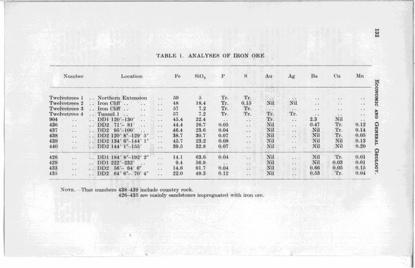
Table 1 gives representative analyses of the ore. which ts generally about 45% !ron, 22% silica, with a uniform low phosphorus and manganese content, and traces of copper in places. Barytes occurs in dykes cutting the ore. at the footwall in DOL Quartz pebbles. presumably derived. from the veins within the replaced sandstones, are fairly common, and two inches diameter on the small iron cliff. The age of the orebody will be considered in the next section.
IX. IRON ORE IN THE DIAL CONGLOMERATE Iron ores are a prominent constituent of the Dial Conglomerate
which unconformably overlies the host rocks of the Iron Cliffs orebody. The pebbles are mainly hard haematite. as occurs within the Penguin Creek orebody, but rare pebbles of the soft. foUated haematite characteristic of this ore occur in the conglomerate on Myrtle Creek, less than a mile from the present outcrop. In places pebbles of haematite are so abundant (Dial Iron Mines) for mining to have been considered. Limonite is rare, but on Dial Peak occurs as boulders up to two feet diameter in the coarse basal conglomerate. The early writers considered the haematite a replacement of the conglomerate. referring to " transmuted conglomerate", and there are unquestioned replacement iron ores at a particular horizon at Myrtle Creek, and fault Infillings on Mt. Dial. However. most of the ore occurs as pebbles, as noted by Thomas (1943. p. 22). Therefore despite the post-Ordovician period of iron mineralisation a source must be found for the pebbles. In the Dial Range, the logical source is the iron deposits immediately west. Since both limonite and haematite occur in the same rock, the possibility of the limonite being formed by post-Ordovician alteration is ruled out. This implies that both the Penguin Creek haematlte ores. and the Iron Cliffs limonite ore, were in existence in pre-Ordovician time.
Carey (1947. p. 28) refers to "Cambrian stratified haematites at the Blythe River "-a deposit closely analogous with the Penguin Creek orebody-and to .. OrdoviCian haematlte pebble conglomerates in the Dial Range ". Although the country rock at the Blythe River is now assigned to pre-Dundas time, and is not necessarily Cambrian, the implications remain, namely. that the haematite ores are preOrdovician.
Campana et al. 0958. p. 52) have suggested a Cambrian iron mineralisation on the west coast.
X. STRUCTURE First Folds
Figure 29 (lower hemisphere projections. Lambert net) shows the cyclographic traces of bedding in the Rocky Cape Group in No . .2 tunnel. Because of a number of cleavages. including one at a low angle to bedding. careful examination was necessary. The laminae were excavated with a knife in the soft. very weathered rock, and bedding determined. from up to half a dozen apparent dips. It is emphasised that the measurements are not a random sampling of a folded tract, but determinatiOns at approximately equal intervals through (not across) a single fold. The fold. termed the Iron CUffs .anticUne. is about 150 feet semi-wavelength. and about 70 teet amplitude. with an axial plane vertical. or dipping east no less than 700
• The inferred profile is given in figure 30. Figure 29 shows contours of bedding intersections, compiled to deflne a precise orientation for construction of the profile. Two small thrusts near the surface

TION DO SEC PROJECTED) (W[TH 0.0.1 &.2 50 rT.
PAO!ioA&LE OUI CRDP EXTENT
~ Iron ore
25 , 9 I
DUNDAS GR,OUP rhonOC6olJ$ ~ ~ h/sl'alh;~a~;a' a~d sandsfone ~ LL-.LI con'j/om
j ROCKY CAPt G I\oup
~ k::::;:::::;:J Sandsfone
~c=J MI/ds/one
BEeDING
Mi2asl/red
Inferred
K L..BURNS GEOLOGIST
1960
ECONOMIC AND GENERAL GEOLOGY. 127
outcrop of the anticline are plotted on he same diagram. The polar locus is close to a small circle, which implies that under the special circumstances outlined, the fold is conical in terms of the traverse path. i.e. the tunnel intersects a variably plunging fold at systematically deeper parts of its proft1e. This variation in plunge is supported by the distribution of the thick sandstone north of tunnel 2.
Groups of minor folds cognate with the Iron Cliffs anticline occur in several places. on the steep eastern limb of the anticline. These show as crenulations in the mudstone, 200 feet from the portal in tunnel 2. associated with a set of oblique shears dipping around 30° east, with reverse movement. Under the big iron cliff, between 115° and 1750 north, the Interbanded mudstone and iron are are similarly crenulated. This outcrop indicates the folding pre-dated the iron ore, as the replacement banding minutely reproduces the folding without fracture, and extends down the shear planes.
The folds are grouped together by orientation and termed first generation, the possibility of earlier deformations not being excluded. The composite profile (figure 27) was constructed on the assumption that this trend is constant, and the overall plunge is gently north. although figure 52 shows small scale reversals.
Second Folds The variable plunge of the first generation folds, and anomalies
at the axis of the Iron Cliffs anticline indicate cross folding. Only one example could be found, at 1470E1620N in interbedded iron are and mudstone. The geometry of this fold is reproduced in figure 29. The fold plunges 75-110°, and was formed by a positive rotation of the common limb through about 80 0
• The axial joint is developed in the iron are as an unhealed fracture. and clearly post-dates the iron are. Bedding through the area shows considerable divergence from the first generation trend, but as in figure 29, the spread can be explained in terms of the two generations outlined above. In this figure it is assumed the second generation crossfolds lie in a constantly oriented axial surface crossing the first generation folds, but this assumption is not a necessary one on the evidence.
The scale and orientation of the two fold generations are such as to require the Cambrian rocks to have participated in the first folding. With the t ime relations of the folding to the iron ore outlined above, this implies that the limonite was formed in postDundas time.
Faults Figure 29 has a plot of all faults observed. The dotted u·aces
appear related to the first generation folding, and at least two are reverse faults. These faults strongly control the distribution of iron ore. The two minor orebodies in t unnel 2 at 150 and 190 feet from the entrance, and others on the surface above the tunnel are formed at the intersection of faults of this type. The main orebody may occupy a large fault zone of this generation.
Shown as solid lines is a smaller group of faults of divergent trend. Not plotted are large dextral faults (shown on the general plan, and inferred from the mapping) which have this trend. A small fault in this direction offsets and slickensides the ore near DDI. The fault in adU 5. striking 120" and dipping 62" south. has a narrow zone of chloritic gouge with sulphide mineralisation.

128 ECONOMIC AND GENERAL GEOLOGY.
SECTION EE
DUND"'!. GROUP
~ F,/s/,alhic ana' carhonoc~ov.$ L..L..-..L:l cony/omerote ona'sondstone
~OCkY C4PE GROUP
c=J Mva'slone ana' 3ana'sfontz
e.[DDIN~
....- Meosurea'
_-- InTer,..a'
Sump/e
2S 50 FT. ! I
FIGURE 31.
5cm
K. L .IJ(JRNS GEOLOGIST
1960
/

ECONOMIC AND GENERAL GEOLOGY. 129
Similar faults intersect 001 in mudstone at 195 feet. carrying traces at lead and silver, and in 002 at 65 feet in sandstone and iron are carrying copper and silver. (Assays in table.)
Since faults in this direction offset the iron are without are in their surfaces, they are post-ore. In particular, this implies that the galena mineralisation of tunnel 5 is post-iron are.
XI. IRON ORE CONTROL The iron are is controlled by a combination of first generation
faulting, occurring at fault intersections and along the fault planes. and bedd1ng. At the south end of the big tron cliff, in the drill holes, in parts of tunnel 2, and in tunnel 1 according to Twelvetrees, the are occurs as thin layers replacing bedding. However In tunnel 2 at 205 feet from the portal the iron are occurs as a diffuse patch with solid are in the centre, diffusing or interfingering outwards into the mudstone.
The Cambrian conglomerates contain patches of vughy limonite. either pebbles or replacement bodies. The sandstone at the end of tunnel 2 contains diffuse patches of limonite, probably a replacement. Limonite in the conglomerate west of tunnel 3 can be seen in places to occur as a replacement at the matrix. This supports the post-Cambrian age assigned the limonite.
The composite profile (figure 27 ) shows the iron ore mushrooming upwards. This effect is real, and may be observed at the big iron cliff, and can be inferred from the general plan and Twelvetrees' observations in No. 1 tunnel. The apparent east lay COUld. however. be due to cross-faulting or dilatation of the orebody northwards.
In general, the iron are runs up the east limb of the Iron Cliffs anticline as a thin dyke. expanding over the crest, and thus has the shape of a saddle reef. It is not Impossible that the haematlte ores of Penguin Creek occupy the west 11mb of the structure.
XII. STRUCTURAL SEQUENCE The three main possibilities for the iron are are-
1. The limonite is gossan capping a sulphide orebody. This was favoured by Montgomery (1896, p. Ix) , Harcourt-Smith <1899. p. x ) . Twelvetrees <1903. p . 15 ; 1905. p. 50). Twelvetrees and Reid <1919. p. 45 ) and Nye and Blake <1938, p. 88). However, it could be capping an original sedimentary pyrite orebody. of which there are indications in the Dundas rocks, or early epigenetic sulphides.
2. The limonite is derived from a haematite orebody originally continuous with that at Penguin Creek. The limonltisatJon would have to follow the first folding, but the haematite could easily be pre-folding, possibly even a sedimentary ore. as suggested by Carey for the Blythe River deposits. Localisation of the llmon!tlsatlon to the edge ot the Dundas trough would be expected.

----- .,.
SECTION FF o 215 ISO FT-. ,-' ___ -'-, __ ...J'
OUNOA5 GROUP
[7""/'"J F,lsp,ofhic ond coroonactlov" LL.....Ll con9/omer"fe and sand!Slone
.OUy CAPI ,,,oUP
r::=J Mlldslone tlnd stlnt/ .. lom>
-
&EOOI"G
,/'" Meosvred
" /" Inferret/
437 Sample
K.L.BliRNS GEOL.OGIST
'9~O
5cm
\ \ \ \ \ \
\ tz:j n 0 2: 0 ~ .... n >-2: t::l
Q t"l 2: t"l :;.:l >-t"'
Q t"l 0 t"'
200' 0 c;l
~
]

I
RECENT
-I.--=-· -.-:: • ...-., Basall scree
TERTIARY
L...I v __ v_1 Basalt
PROBABLE OUTCROP EXTENT
~/ron orq,
CAMBRIAN
I I SUD -hasalfic ~ 6 t::.. fllrrestrlol 9ravllis
~ :3 Dundas Group, mudsiont2s t2fc
PRECAMBRIAN ~~- I R, k Capfi1 Group \::::;::: " I m~~'1tone and sand.sfon~ ~ Faull
........... Mmor folds
.... - .... Tracl<.
~ Footpafh
70· Strlxe and dIp of beddm!!
~ . f schIstosity or cleavaye BO~ StrIke and dIp ° 60"-<:::t Sir"",,! and dIp of /omts
II ledae sou/hqrn .300 ' A S .L (Approx) Sma J
Da/um d 01 small Iron cit/I· 1000£ IOOON
qn Sf / Grtd) (40.312£ 9.3216N a e
KL BURNS GE'OLOGlST
/960
GENERAL PLAN IRON CLIFFS AREA
o I
100 I
FIGURE 52.
200 FEET I
l Scm
•
V
V
V
V
v
V V --V
V V
V V
V
V
V V V
V V V
V V V
V
V

IRON CLIFFS AREA AROUND D.O. HOLE I.
PR.(lSA-Blf OUTC'tOP EXTENT
~
~
DIP
50
'RON ORE
C.A.MBR,I"N.
DUNDAS uROUP - MUD5,DNES
PRf.C"MBRIAN .
CLEAVAGE
FAULT WITH DIP
MINOR fOLD "'''15
100 FT.

ECONOMIC AND GENERAL GEOLOGY. 131
3. The limonite was emplaced directly as such.
The second alternative is definitely favoured. With this the structural sequence becomes: -
(a) The Rocky Cape Group, containing siderite veins, quartz veins, and possibly haematite replacement or sedimentary iron ore, and unconformable Dundas Group greywackes containing much Rocky Cape detritus, were deformed together in the first generation folding, with faulting at the same time.
(b) Limonite was formed from the haematite, or limonite emplaced directly, the mineralisation replacing bedding but with strong fault control. From the existence of limonite pebbles in the Dial Conglomerate. this event was pre-Ordovician, and on structural evidence and replacement of Cambrian conglomerates (in other places in the Dial Range, as well as the Iron Cliffs), was post-Dundas Group. This concords with mineralisation at this time inferred by Campana.
(c) Second generation folding, on a minor scale, mainly confined to the eastern limb of the Iron Cliffs anticline. This folding refolded the iron ore.
(d) Second generation faulting, possibly later than phase (e), with dextral movement on steep surfaces striking east-south-east. These faults offset and slickenside the iron ore.
(e ) Mineralisation of faults of phase (d) with the zinc blende and galena of the Badgers mine.
XIll. CONCLUSIONS
Only a tentative choice can be made between the main alternative origins for the iron ore. However it is clear that the sulphide mineralisation at the Badgers mine is no evidence for the limonite being a gossan, the lead mineralisation appearing to be an event much later than the formation of the limonite. Even without this, any gossan could as well overlie syngenetic pyrite as any more valuable metal .
If the material is a gossan, it extends to considerable depths and deep drilling will be necessary to get beneath the oxidised zone. Essential preliminary investigations are a general survey of the relations of the Penguin Creek and Iron Cliffs orebodies, mineragraphic investigation of the sequence of mineralisation, and sluicing of the overburden in selected parts of the Iron Cliffs area (particularly along the eastern boundary of the limonite ore) to enable a thorough survey of the outcrop.
~
'" ..,
TABLE 1. ANALYSES OF IRON ORE
Number Loca.tion Fe SiD, p S Au Ag B. Ou 1\1n 01
" ~ Twelvetl'OOs 1 NOI,thot'1l Extension 59 5 Tr. '1'1'. ! Twelvetrees 2 Iron Cliff . . 4~ ISA TL 0.15 Nil Nil
" Twelvetl-ecs 3 Iron Cliff 57 7.2 Tr. Tr. > Twelvetrecs 4 TUlmel 1 57 7.2 Tr. Tr. Tr. Tr. Z 904 DDI 120'- 130' 45.4 22.4 Tr. 2.3 Nil 0
436 DD2 71'- 81 ' 4404 26.7 0.05 Nil 0.47 Tr. 0.12 0 437 DD2 95'- 100 ' 46.' 23.6 0.04 Nil Nil Tr. 0.14 ~ z 43S DD2 120' S"-129' 5" 3S.7 30.7 0.07 Nil Nil Tr. 0.05 ~
439 OD2 134' 6"- 144 ' I" 45.7 23.2 O.OS Nil Nil Nil 0.13 ~ >
HO DD2 144' 1"'-155' 39.5 32.S 0.Q7 Nil Nil Nil 0.20 ~
0 426 DDI IS4 ' S"-192 ' 2" 14.1 63.6 0.0' Nil Nil Tr. 0.01 ~
0 429 DDI 222'- 232' 9.4 56.9 Nil Nil 0.03 0.01 ~
0 433 DD2 56'- 64 ' 6 .... 14.6 61.7 0.04 Nil 0.66 0.05 0.15 '" 435 DD2 64' 6"- 70' 4" 22.0 49.3 0.12 Nil 0.53 'fl'. 0.Q4 ~
Non;.~Tha.t numbeL's 438- 439 include COWltl'Y rock. 426-435 are mainly sandstones impregnated with iron ore .

TABLE 2. MISCELLANEOUS ANALYSES
Numbel' Location Fe SiO! l' S Au Ag B .. BaBO I Cu ~ln Pb em'bon t'J n
----- 0 Z
!JO:! DOl 110 '-J20 ' 12.8 24.0 '1" ', 55. 1 ~il ~ tlO.; DDI 130'-136 ' 6" l.8 6.8 Nil 90.9 Nil " 425 DDI 136' 6"-145 ' 0" 6.3 38.20 0.02 Nil 34.3 '1'1'. 0.01 >
Z ~
427 DDI 192 ' 2"-196' 11" .. Nil Tr. Nil 1'r. 0 434 DD2 65 ' 1"'- 65 ' 10"' . . Nil 1'1". 0.08 Nil ~
z 430 002 8' 9"- 9 ' 6'" 25.4 0.02 Nil ~il Nil 0. 12
~ ~
431 DD2 9' 0"- 19' I " 5. 4 0.05 Nil Nil 0.01 1.55 > ~
432 DD2 19 ' 1"- 30 ' 3" 4.5 0.03 ~il N il N il 0.70 0 ~
4-28 DDI 209 ' 10"-212 '6"- Nil Tl' . Nil Nil 0 ~ 0
" Samples: 903-425 arc bary tes Jodes at nmdijtone-iron 0 1"6 bounda,'y. ~
427- 434 are faul t gouge. 430-432 are Cambl'ian conglomcl·ate. 428 is R ock y Capo mudl!Ctonc with 8idc rit o vci ni'l.

134 ECONOMIC AND GENERAL GEOLOGY.
REFERENCES.
CAM I'ANA, B.; DICKINSON. S. 8.; KING. O. and MATIlEiWN. R . S . • 19S8.- Tbe Mine"RUsed Rift Valleys of Tasmania. ANd.I .M.M . (Stillwell VolNm e ) pp. 41-60.
CAkEY, S. W., 1947.- Report of the Government Geologist (01' 1945. Uf;J)ort Vir. MiM' Tal . for 1945, pl>.21-29.
HAROOURT-SJfITU . J., 18S9.- Report on the P enguin and Dial Range Mineral Field3. Report Sec. Mi7U!fJ Ta.. (or 1898-99, pp. ill"-xii.
MONTGOMF-RY. A., 189S.- Report on the Mineral Fields or the Gawler River, Penguin, Dial Range, Mount Housetop, Table Cape, Cam River and portion of the Arthur River Districts. Report Set;. Mine. Taa. for 1895-96. pp. i-xx.
Ny", P. B. and BLAKE, F., 1935.-The Geology and Mineral Deposita of Tasmania. Ta •. Geol. Surv. BuU. 4-4, 11 3 pp.
TUOMAS, D. E., 1945.- Report of the Geologieal Survey. Report ViT. Minel! TIJ.3. tor 1948, pp. 21·24.
TWtlJl,VF.TIlKES, W, H ., 1903,-Repo1't on the Dial Range and l:Iome other MineI'M! Di8t.l'ietg Oil the North-West Coast o f Tasmania. TUil. Dfmt. Mittel! Old SIJriCtl Publicat i01l8. 211. pp. 1_27.
_____ ____ • 1906.- Repo1't on North-West COBst Mineral DepOlli ts. AKn, Ue110rt See. Mine. Ta •• (or 1905, Pl). 9-59.
______ __ ~ and RElD. A. M., 1919.- The Iron Ore Dep08itl ot Tas ruanilL. Tal! . (;eol. Surv. Mitt . He". No.6, 116 pp.
APPENDIX
by G. Everard.
The following descriptions apply to specimens collected by geologist Kerry Burns at Iron Cliffs near Penguin.
Specimens two and three, both described as mudstones. differ greatly in the amount of quartz present. No.2 contains much quartz which is the most abundant mineral. whereas in No. 3 there are only occasional grains in a dense sericitic matrix.
Specimens one and four are very different. Specimen No, 1 is an indurated quartzose mudstone intermediate between two and three with the addition of pebble-like masses of recrysta11ised quartz. whereas No.4 contains various rock fragments in addition to grains of quartz. However no fragments of specimens Nos. 1 and 2 could be identified in No, 4.
Specimen No. 7 may be a recrystallised version of No.5, its palimpsest structures representing the rounded grains seen in NO.5. Specimen No.6 has quite a different structure.
(1) Iron Cliffs D.D.H. No.1 . 190 feet-Fine grained pale grey siliceous rock. stained with haematite
and limonite. In thin section the rock consists of a matrix of sericite and
quartz containing larger angular grains of quartz about 0.1 mm. across. and masses of quartz mosaic of much coarser granularity. and about 1 nun. in length. These latter have the appearance of recrystallised stretched pebbles. Granules of opaque white clay material are disseminated through the rock. which also contains irregular patches of haematite largely altered to limonite and small grains of the same mineral.
The rock is an indurated quartzose mudstone. (2) Iron Cliffs D.D.H. No.1, 210 feet-
Fine grained. moderately soft. pale grey rock with carbonate veinlets.
w

ECONOMIC AND GENERAL GEOLOGY. 135
In thin section the rock is a fine grained mosaic of irregular quartz grains interlaced with laths of sericite. Small aggregates of carbonate are plentiful and there is much disseminated. white opaque clay mineral and black opaque iron ores.
The rock is a quartzose mudstone. (3) Mudstone from No.5 Adit, Iron CUffs-
Pale grey. fine grained rock. well bedded and jointed. In thin section the rock is an extremely fine grained mass
of sericite, with much opaque white clayey material and scattered larger grains of Quartz and opaque iron ore.
- (4) No.5 Adit. Iron Cliffs-Pale grey. fine gra ined rock containing angular and sub~
rounded grains both dark and light. In thin section the rock consists of a very fine sel'icitic
matrix containing much very fine opaque yellow material. The angular fragments, averaging about 1 mm. across, consist of quartz, Quartzite, mudstone and graphitic shale. Some frag~ ments contain minute biotite plates and there are also inclusions of iron ores.
The rock 15 a greywacke. (5) Station 12, Iron Cliffs-
Pale coloured, flne grained rock. stained brown and red by weathering. Many small fragments, rather less than 1 mm. across can be seen in hand specimen.
In thin section the rock is a mass of roughly rounded sericitic and Quartz grains separated by thin layers of fine grained material stained brown by limonite. There are occasional irregular larger grains up to 2 mm.
The rock is an indurated arkosic greywacke. (6) Seventy eight feet from portal Adit No.3, Iron Cliffs--
Pale grey. fine to medium grained rock which scratches fairly easily. Different minerals cannot be distinguished except for a few small scattered crystals of pyrite. Small sQuarish holes show where pyrite has been weathered out.
In thin section the rock is a mass of interlocking allotrio~ morphic grains of felspar. heavlly charged with fine fiakes of sericite. Occasional larger irregular grains and idiomorphic crystals are completely sericitised. There are rare clear rounded grains of Quartz and irregular masses of secondary Quartz, with inclusions and a fibrous tendency. Opaque white material and limonite are common.
The specimen is a recrystallised felspathic rock much sericitised. (7) Extreme end of No.2 Adit. Iron Cliffs-
The specimen is a whitish coloured rock, consisting of a fine grained matrix in which are scattered relatively darker crystals averaging 1 mm. across.
In thin section the darker crystals appear as felspar com~ pletely altered to sericite. The matrix consists of quartz and sericite. There are a few opaque irregular crystals of black iron ore minerals and white leucoxene.

136 ECONOMIC AND GENERAL GEOLOGY.
The Quartz and sericite of the matrix are mingled with blades of sericite penetrating the individual grains of an interlocklng mosaic of quartz. The matrix is crowded with rough rings of opaque white clay mineral about 0.1 mm. across, i,e. about the same size as the Quartz grains but not corresponding exactly with them. It may be a pallmpsest structure and represent original grains. the whole having subsequently recrystaUtsed.
The specimen is a recrystallised Quartz-sericite rock.