Embed Size (px)
Citation preview

1

2
7th
INTERNATIONAL SYMPOSIUM
ON UNDERWATER RESEARCH
20-22.03.2013 WROCŁAW (POLAND)
PROGRAMME
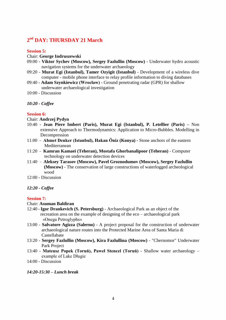
1st DAY: WEDNESDAY 20 March
09:00 – Registration
10:00 – Opening Session
Welcome by prof. Gościwit Malinowski
(Head of Institute of Classical, Mediterranean
and Oriental Studies University of Wrocław)
Welcome by prof. Sławomir Moździoch
(Head of Wrocław Department of Institute
of Archaeology and Ethnology Polish Academy
of Sciences)
Welcome by prof. Ahmet Adil Tirpan
(Head of Department of Archaeology
Selcuk University in Konya - Turkey)
Welcome by dr. Murat Egi
(Divers Alert Network Europe)
Welcome by dr. Sergey Fazlullin
(Institute of Oceanology Russian Academy
of Sciences)
Welcome by dr. Hakan Öniz
(Department of Archaeology Selcuk University, Konya,
Coordinator of UNESCO Underwater Archaeology
Unitwin Network
10:30 - Special lecture by Nihal Tirpan –
vice-director of Museum of Anatolian Civilizations,
Ankara
3
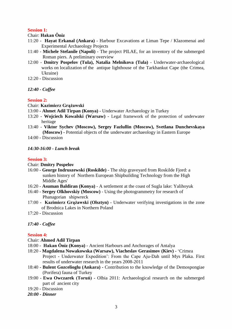
Session 1: Chair: Hakan Öniz
11:20 - Hayat Erkanal (Ankara) - Harbour Excavations at Liman Tepe / Klazomenai and
Experimental Archaeology Projects 11:40 - Michele Stefanile (Napoli) - The project PILAE, for an inventory of the submerged
Roman piers. A preliminary overview
12:00 - Dmitry Pospelov (Tula), Natalia Melnikova (Tula) - Underwater-archaeological
works on localization of the antique lighthouse of the Tarkhankut Cape (the Crimea,
Ukraine)
12:20 - Discussion
12:40 - Coffee
Session 2: Chair: Kazimierz Grążawski
13:00 - Ahmet Adil Tirpan (Konya) - Underwater Archaeology in Turkey
13:20 - Wojciech Kowalski (Warsaw) - Legal framework of the protection of underwater
heritage 13:40 - Viktor Sychev (Moscow), Sergey Fazlullin (Moscow), Svetlana Dunchevskaya
(Moscow) - Potential objects of the underwater archaeology in Eastern Europe
14:00 - Discussion
14:30-16:00 - Lunch break
Session 3: Chair: Dmitry Pospelov
16:00 - George Indruszewski (Roskilde) - The ship graveyard from Roskilde Fjord: a
sunken history of Northern European Shipbuilding Technology from the High
Middle Ages'
16:20 - Asuman Baldiran (Konya) - A settlement at the coast of Sugla lake: Yalihoyuk
16:40 - Sergey Olkhovskiy (Moscow) - Using the photogrammetry for research of
Phanagorian shipwreck
17:00 - Kazimierz Grążawski (Olsztyn) - Underwater verifying investigations in the zone
of Brodnica Lakes in Northern Poland
17:20 - Discussion
17:40 - Coffee
Session 4: Chair: Ahmed Adil Tirpan
18:00 - Hakan Öniz (Konya) - Ancient Harbours and Anchorages of Antalya
18:20 - Magdalena Nowakowska (Warsaw), Viacheslav Gerasimov (Kiev) - ‘Crimea
Project - Underwater Expedition’: From the Cape Aju-Dah until Mys Plaka. First
results of underwater research in the years 2008-2011
18:40 - Bulent Gozcelioglu (Ankara) - Contribution to the knowledge of the Demospongiae
(Porifera) fauna of Turkey
19:00 - Ewa Owczarek (Toruń) - Olbia 2011: Archaeological research on the submerged
part of ancient city
19:20 - Discussion
20:00 - Dinner
4
2nd
DAY: THURSDAY 21 March
Session 5: Chair: George Indruszewski
09:00 - Viktor Sychev (Moscow), Sergey Fazlullin (Moscow) - Underwater hydro acoustic
navigation systems for the underwater archaeology
09:20 - Murat Egi (Istanbul), Tamer Ozyigit (Istanbul) - Development of a wireless dive
computer - mobile phone interface to relay profile information to diving databases
09:40 - Adam Szynkiewicz (Wrocław) - Ground penetrating radar (GPR) for shallow
underwater archaeological investigation
10:00 - Discussion
10:20 - Coffee
Session 6: Chair: Andrzej Pydyn
10:40 - Jean Piere Imbert (Paris), Murat Egi (Istanbul), P. Letellier (Paris) – Non
extensive Approach to Thermodynamics: Application to Micro-Bubbles. Modelling in
Decompression
11:00 - Ahmet Denker (Istanbul), Hakan Öniz (Konya) - Stone anchors of the eastern
Mediterranean
11:20 - Kamran Kamaei (Teheran), Mostafa Ghorbanalipoor (Teheran) - Computer
technology on underwater detection devices
11:40 – Aleksey Tarasov (Moscow), Pavel Groznodumov (Moscow), Sergey Fazlullin
(Moscow) - The conservation of large constructions of waterlogged archeological
wood
12:00 - Discussion
12:20 - Coffee
Session 7: Chair: Asuman Baldiran
12:40 - Igor Drankevich (S. Petersburg) - Archaeological Park as an object of the
recreation area on the example of designing of the eco – archaeological park
«Onega Petroglyphs»
13:00 - Salvatore Agizza (Salerno) - A project proposal for the construction of underwater
archaeological nature routes into the Protected Marine Area of Santa Maria di
Castellabate
13:20 - Sergey Fazlullin (Moscow), Kira Fazlullina (Moscow) - "Chernomor" Underwater
Park Project
13:40 - Mateusz Popek (Toruń), Paweł Stencel (Toruń) - Shallow water archaeology –
example of Lake Długie
14:00 - Discussion
14:20-15:30 – Lunch break
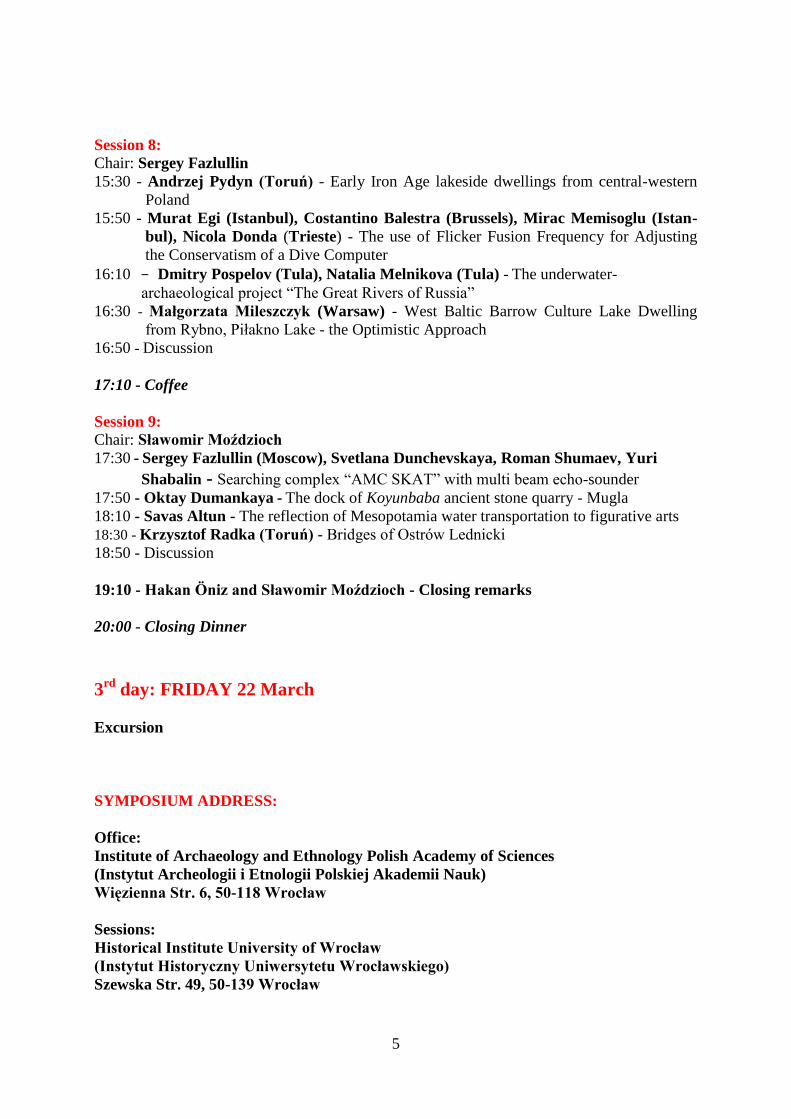
5
Session 8: Chair: Sergey Fazlullin
15:30 - Andrzej Pydyn (Toruń) - Early Iron Age lakeside dwellings from central-western
Poland
15:50 - Murat Egi (Istanbul), Costantino Balestra (Brussels), Mirac Memisoglu (Istan-
bul), Nicola Donda (Trieste) - The use of Flicker Fusion Frequency for Adjusting
the Conservatism of a Dive Computer
16:10 - Dmitry Pospelov (Tula), Natalia Melnikova (Tula) - The underwater-
archaeological project “The Great Rivers of Russia”
16:30 - Małgorzata Mileszczyk (Warsaw) - West Baltic Barrow Culture Lake Dwelling
from Rybno, Piłakno Lake - the Optimistic Approach
16:50 - Discussion
17:10 - Coffee
Session 9: Chair: Sławomir Moździoch
17:30 - Sergey Fazlullin (Moscow), Svetlana Dunchevskaya, Roman Shumaev, Yuri
Shabalin - Searching complex “AMC SKAT” with multi beam echo-sounder
17:50 - Oktay Dumankaya - The dock of Koyunbaba ancient stone quarry - Mugla
18:10 - Savas Altun - The reflection of Mesopotamia water transportation to figurative arts
18:30 - Krzysztof Radka (Toruń) - Bridges of Ostrów Lednicki
18:50 - Discussion
19:10 - Hakan Öniz and Sławomir Moździoch - Closing remarks
20:00 - Closing Dinner
3rd
day: FRIDAY 22 March
Excursion
SYMPOSIUM ADDRESS:
Office:
Institute of Archaeology and Ethnology Polish Academy of Sciences
(Instytut Archeologii i Etnologii Polskiej Akademii Nauk)
Więzienna Str. 6, 50-118 Wrocław
Sessions:
Historical Institute University of Wrocław
(Instytut Historyczny Uniwersytetu Wrocławskiego)
Szewska Str. 49, 50-139 Wrocław
6
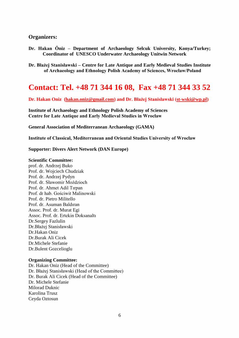
Organizers:
Dr. Hakan Öniz – Department of Archaeology Selcuk University, Konya/Turkey;
Coordinator of UNESCO Underwater Archaeology Unitwin Network
Dr. Błażej Stanisławski – Centre for Late Antique and Early Medieval Studies Institute
of Archaeology and Ethnology Polish Academy of Sciences, Wrocław/Poland
Contact: Tel. +48 71 344 16 08, Fax +48 71 344 33 52
Dr. Hakan Oniz ([email protected]) and Dr. Błażej Stanisławski ([email protected])
Institute of Archaeology and Ethnology Polish Academy of Sciences
Centre for Late Antique and Early Medieval Studies in Wrocław
General Association of Mediterranean Archaeology (GAMA)
Institute of Classical, Mediterranean and Oriental Studies University of Wrocław
Supporter: Divers Alert Network (DAN Europe)
Scientific Committee:
prof. dr. Andrzej Buko
Prof. dr. Wojciech Chudziak
Prof. dr. Andrzej Pydyn
Prof. dr. Sławomir Moździoch
Prof. dr. Ahmet Adil Tırpan
Prof. dr hab. Gościwit Malinowski
Prof. dr. Pietro Militello
Prof. dr. Asuman Baldıran
Assoc. Prof. dr. Murat Egi
Assoc. Prof. dr. Ertekin Doksanaltı
Dr.Sergey Fazlulin
Dr.Błażej Stanisławski
Dr.Hakan Oniz
Dr.Burak Ali Cicek
Dr.Michele Stefanie
Dr.Bulent Gozcelioglu
Organizing Committee:
Dr. Hakan Oniz (Head of the Committee)
Dr. Błażej Stanisławski (Head of the Committee)
Dr. Burak Ali Cicek (Head of the Committee)
Dr. Michele Stefanie
Milorad Duknic
Karolina Trusz
Ceyda Oztosun
7
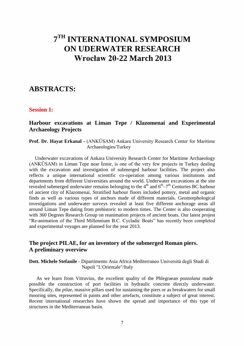
7TH
INTERNATIONAL SYMPOSIUM
ON UDERWATER RESEARCH
Wrocław 20-22 March 2013
ABSTRACTS:
Session 1:
Harbour excavations at Liman Tepe / Klazomenai and Experimental
Archaeology Projects
Prof. Dr. Hayat Erkanal - (ANKÜSAM) Ankara University Research Center for Maritime
Archaeologies/Turkey
Underwater excavations of Ankara University Research Center for Maritime Archaeology
(ANKÜSAM) in Liman Tepe near İzmir, is one of the very few projects in Turkey dealing
with the excavation and investigation of submerged harbour facilities. The project also
reflects a unique international scientific co-operation among various institutions and
departments from different Universities around the world. Underwater excavations at the site
revealed submerged underwater remains belonging to the 4th
and 6th
–7th
Centuries BC harbour
of ancient city of Klazomenai. Stratified harbour floors included pottery, metal and organic
finds as well as various types of anchors made of different materials. Geomorphological
investigations and underwater surveys revealed at least five different anchorage areas all
around Liman Tepe dating from prehistoric to modern times. The Center is also cooperating
with 360 Degrees Research Group on reanimation projects of ancient boats. Our latest projest
“Re-animation of the Third Millennium B.C. Cycladic Boats” has recently been completed
and experimental voyages are planned for the year 2013.
The project PILAE, for an inventory of the submerged Roman piers.
A preliminary overview
Dott. Michele Stefanile - Dipartimento Asia Africa Mediterraneo Università degli Studi di
Napoli "L'Orientale"/Italy
As we learn from Vitruvius, the excellent quality of the Phlegraean pozzolana made
possible the construction of port facilities in hydraulic concrete directly underwater.
Specifically, the pilae, massive pillars used for sustaining the piers or as breakwaters for small
mooring sites, represented in paints and other artefacts, constitute a subject of great interest.
Recent international researches have shown the spread and importance of this type of
structures in the Mediterranean basin.
8
Nevertheless, in the area of maximum diffusion, i.e. the Phlegraean Fields, not far from
the pozzolana quarries, and in the middle of a territory with a unique state of preservation of
the archaeological structures and with an impressively high density of ancient sites, on land
and underwater, the documentation of the numerous pilae visible underwater is sometimes
incomplete or absent.
The project PILAE, in its first phase, aims to record all pilae visible in the area between
the city of Naples and the promontory of Cape Misenum, collecting the scattered literature and
documenting structures in a uniform manner, in order to provide an updated and useful
database, looking for standards (and variations) in shapes, dimensions, building techniques.
For the later stages of the project, it is proposed to increase the area of investigation to the
entire Tyrrhenian coast, and finally the entire Italian Peninsula.
Underwater-archaeological works on localization of the antique lighthouse
of the Tarkhankut Cape (the Crimea, Ukraine)
Prof. Dr. Dmitry Pospelov - Centre of Underwater Research Tula State Lev Tolstoy
Pedagogical University, Tula/Russia
Natalia Melnikova - Centre of Underwater Research Tula State Lev Tolstoy, Tula/Russia
Pedagogical University
The problem of localization of the antique lighthouse of the Tarkhankut Cape has been
regularly raised by researchers. The existence of some signal point in that area is testified by
two things.
The first one is that the geographical position of the Karadzha Bay of the Tarkhankut Cape
is very convenient for having there a navigation base. Topographic, archaeological and
underwater-archaeological data with all probability shows that the Karadzha settlement had an
essential role in the system of ancient navigation in the Black Sea in the VI century BC – the
II century AD.
The second testimony is given by the toponymical component of our investigation. We
found some Turkish, Latin (Greek) historical names of that area, all their meanings are related
with modifications of the words «lighthouse», «red light», «purple», etc.
A few years ago the research of the close sea zone of the Tarkhankut Cape started.
Underwater-archaeological exploration showed that a stone ridge extends on the seabed for 1
sea mile to the west of the Tarkhankut Cape. On its extremity at a depth of 3,6 m there is a
huge quantity of stones.
The sea level of the antique and medieval age was lower and the western side of the ridge
raised above the water for 3-5 m to that of present-day. Apparently sailing directions of the
XIX century mention ruins of the ancient lighthouse that submerged by the transgression of
the Black Sea.
Finally the ruins of the lighthouse were found, but the research is still in process. Further
underwater-archaeological works will give information concerning dating, origin and many
other historical and archaeological aspects.

9
Session 2:
Underwater Archaeology in Turkey
Prof. Dr. Ahmet Adil Tirpan - Department of Underwater Archaeology, Selcuk University,
Konya/Turkey
It is possible to say that the science of underwater archaeology has been established in
Turkey approximately 50 years ago by one of the distinguish professors, George Bass. Many
artefacts from their excavations are in the exhibitions of Bodrum underwater archaeology
museum which is the oldest museum on this field. Underwater research and excavations
which were organized by Turkish Archaeologists have been realized at Tekirdag coast by
Tekirdag Museum 14 years ago, at Marmara Island by Istanbul University 10 years ago, at
Antalya coast by Antalya Museum 8 years ago and at Alexandria Troias ancient city of
Canakkale by Selcuk University 5 years ago. Projects on the same field are active at the coasts
of Antalya, at Kekova Island of Antalya, at Kucukcekmece Lake of Istanbul, at Knidos
ancient city of Mugla by Selcuk University, at Limantepe of Izmir by Ankara University, at
the coast of Aegean Sea by 9 Eylul University. The first underwater archaeology department
established in Selcuk University of Konya at 2000 and 30 master and 5 Ph.D. students already
graduated from them. Now, this university is the Lieder University of UNESCO Unitwin
Network for Underwater Archaeology.
Legal framework of the protection of underwater heritage
Prof. Dr. Wojciech Kowalski - Polish Ministry of Foreign Affairs, Warsaw/Poland
Author will discuss legal framework of the protection of underwater heritage in the context
of marine archaeology. Although this analysis is to be focused on the UNESCO 2001
Convention also the protection on the basis of earlier legal instruments will be clarified. This
is due to the fact that several countries have not yet ratified the Convention.
Potential objects of the underwater archaeology in Eastern Europe
Dr. Viktor Sychev – Institute of Oceanology Russian Academy of Sciences, Moscow/Russia
Dr. Sergey Fazlullin – Institute of Oceanology Russian Academy of Sciences,
Moscow/Russia
Svetlana Dunchevskaya – Research and Production Enterprise FORT XXI Ltd. Co,
Moscow/Russia
The purpose of this report is to provide an overview concerning the promising areas in
Eastern Europe for the underwater archaeological research and the advanced technical means
suitable look for the underwater cultural heritage objects. The maps are considered of such
medieval state entities, as the Great Bulgaria, the Khazar Khanate, the Principality of Ancient
Russ, the Golden Horde and so on that include the cities and their surroundings, as a rule,
river water areas. There are indicated that the specific of the conducting underwater
archaeological research in rivers requires using the modern technology and attracting the
qualified specialists. There are some examples illustrating the possibilities of modern

10
technology or search, identify and monitor the underwater archaeological objects. It is noted
that the market offers a wide range of the means for surveying the bottom surface objects but
it do not almost presents the means to find the under bottom objects. In this regard, it is
supposed to use for this purpose the parametric side scan sonars. To overcome the problems
connected with the high cost of the modern technical means and need to attract qualified
professionals we suppose to use the consortium structure. There are some examples of the
underwater archaeological researches that are realized according to the said structure by the
Innovative Center “Sea Technology”, Research and Production Enterprise “FORT XXI” and
the Russian Underwater Confederation.
Session 3:
The ship graveyard from Roskilde Fjord: a sunken history of Northern
European Shipbuilding Technology from the High Middle Ages'
Dr. George Indruszewski - Viking Ships Museum, Roskilde/Denmark
The long history of underwater and maritime research in Northern Europe was definitely
enriched with the accidental discovery in 1997 of no less than nine ship derelicts underneath
the modern shoreline of the Roskilde Fjord in Roskilde, Denmark. This exceptional cluster of
finds were archaeologically documented, excavated and retrieved during 1997 and 1998, eight
of these ship derelicts being currently under conservation treatment in the National Museum
Conservation Laboratory in Brede, Copenhagen.
Dated between 1050 and 1350, they attest not only to the geomorphological context of the
Roskilde Fjord in the High Middle Ages, but also display many technological details
pertaining to the shipbuilding in Northern Europe in a period from which few ships are
available for study today.
The presentation is focused herewith on the actual shipfinds and their technological details
on the background offered by contemporary archaeological finds from Northern Europe. The
conclusion will highlight the interpretation that seems closer to the past reality of those unique
finds by heavily leaning on the digital-based modelling of wreck-site formation process.
Additional geographic information will be used to reconstruct the early seascape in a
digital environmental that probably helds the clue to the clustering of these finds at the
southernmost end of the Roskilde Fjord.
A settlement at the coast of Sugla lake: Yalihoyuk
Prof. Dr. Asuman Baldiran – Institute of Archaeology Selcuk University, Konya/Turkey
Sugla lake (ancient Trogitis) is at the southeast of Lake Beyşehir and is located between
Bozkir and Seydisehir. This lake is mentioned by Strabo in his texts. Ramsay, Mellaart,
Bordaz and Levick have made various studies at the same region.
Mellaart had extensive wide range research from the prehistoric period between Sugla
Lake and Beyşehir. Solecki and his team detected Suberde Hoyuk at the lake coast and found
some traces from the Paleolithic period at the west of the lake in 1963.
11
In this study we mainly focused to some archaeological remains around of Yalihoyuk
archaeological site which is located in Yalihoyuk town. There was no excavation yet in this
site and majority of the remains are from the Roman periods. These remains had been brought
in various ways to this region.
Using the photogrammetry for research of Phanagorian shipwreck
Sergey Olkhovskiy – Institute of Archaeology Russian Academy of Sciences,
Moscow/Russia
In 2012 the underwater unit of Phanagorian expedition IA RAS was engaged in search
for new objects in the flooded part of Phanagoria site. During an underwater excavation we
found the wreckage of a wooden ship, covered by 1.5 m layer of sea sediments. Dimensions
of the ship’s hull were about 15 meters in length and 3 m in width at midship. Drawing of the
ship was complicated by the lack of working time, low level of water (1.5 meters), persistent
strong winds and waves, low transparency of water and a big amount of floating seaweeds.
We had to refuse the traditional method of manual measurements and apply a combined
approach by the means of photogrammetry and tachymetry. It allowed us to move the
drawing of the ship to post-processing phase and to reduce the duration of underwater work
and physical impact on the frail wood.
For accurate location of the ship into a GIS and monitoring the accuracy of
photogrammetry, we created a network of 200 reference points and fixed their coordinates by
the means of coastal Total Station. When the transparence of water was sufficient, we made
600 vertical photos by the means of a horizontal frame, moving along the ship, and 200
additional side photos to eliminate possible blind spots.
As a main processing tool, we chose software AgiSoft Photoscan Pro, which made a
"digital snapshot" of the ship. It consists of 650 thousand polygons. This model will be used
as a source of information about real dimensions of ship’s details for future virtual
reconstruction of the ship in Autocad. This technique proved its effectiveness for rapid
fixation of objects in situ.
Underwater verifying investigations in the zone of Brodnica Lakes in
Northern Poland
Prof. Dr. Kazimierz Grążawski - University of Warmia and Mazury in Olsztyn/Poland
The aim of this presentation is to summary archaeological verifying underwater
investigations which took place in Northern Poland around the zone of Brodnicas' Lakes.
Some of this underwater archaeological sites were well-known from earlier investigations -
the piles settlements in Łąkorek and Skarlin, also the sites on lakes' islands (Radomno,
Chojno, Great Partęczyny), moreover - the bridge crossing on Lake Robotno.
The investigations were not only to evaluate the condition of the conservation of the relics
gathered before 25 years in for example Łąkorek Lake - dendrodates XIV and XVII? century
but to verify dating through gaining over new samples for dendrodates.
Another purpose of the investigations in area of Brodnica Lakes was to make the plan of
bridge crossing on the lake Robotno (approx. 1700 a.c.). The verification of the zones close to
the coasts of lake islands with the sites (lake Great Partęczyny, Chojno, Radomno) it did not
12
confirm the existence of the constructional elements - as harbors, platforms or at least bridges
which could connect these colonial (Great. Partęczyny) or cult (Chojno, Radomno) objects.
Session 4:
Ancient Harbours and Anchorages of Antalya
Dr. Hakan Öniz - Department of Archaeology, Selcuk University/Turkey
Antalya is a large touristic sity located at the south-west coast of the Turkish
Mediterranean with many archaeological traces of an uninterrupted history from earliest man
to the present. This province has a 640 km. coastal strip on the Mediterranean, and includes
the ancient regions of Lycia, Pamphylia and Cilicia. Harbours, anchorages, mooring stones,
lead stocks of wooden anchors, several kinds of iron anchors, stone fishing sinkers and also
shipwrecks have been found during the first systematic underwater survey in this region.
Especially anchors have potential to indicate ancient harbours and anchorages. All remains,
harbours and anchorages which were found during the project between 2009 and 2012 are
indicating activities from different periods but mainly Helenistic, Roman and Byzantion
periods.
‘Crimea Project - Underwater Expedition’: From the Cape Aju-Dah until
Mys Plaka. First results of underwater research in the years 2008-2011
Dr. Magdalena Nowakowska – Institute of Archaeology University of Warsaw/Poland
Dr. Viaczeslav Gerasimov – National Ukrainian Academy of Sciences, Kiev/Ukraina
The Polish – Ukrainian venture Crimea Project – Underwater Expedition, was being
executed since year 2007. The aim is to discover, explore and protect from destruction and
robbery the wracks, anchorages or other archaeological underwater sites located by the
southern coasts of Crimea.
During the last three seasons scientific research has been basically focused on verification
already known sites and searching for the new ones in the Bay of Karasan – from the Cape
Aju-Dah until a small cape called Mys Plaka and the rocks of Adalary which enclose the bay
from the East.
As a result, the information about three antic wracks published by Ukrainian researchers
has been verified and there have been localised new underwater sites.
At the Eastern edge of the Karasan bay, in the shallow water, at the depth of 6-10 m,
between rocks was found a large cluster of pottery. Fragments of amphorae and pithoi were
lying on a not large space of ca. 150 m2. Among them was distinguished the Mediterranean
type common in this area from the 11th
c. and fragments of older amphorae type carrots dated
to the 8th
– 9th
c. So big concentration of ceramic in one spot could be an effect of sea waves’
and currents’ movements which were being transported crashed pottery from sunken ships.
The exploration at the site was carried on using ejector. There were dug up two small probing
trenches to determine the thickness of a layer that had been accumulated on hard bottom.
Besides exploration, there was being conducted also systematic survey using side scan
sonar and active sonar (echo sounding). The area which has been covered with the survey
13
encompasses the whole bay of Karasan until the depth of 50 meters and waters around Cape
Aju-Dah. As a result there were registered several bottom anomalies deeper then 40 meters.
Researches around Cape Aju-Dah, the place that undoubtedly used to be in the past an
important navigation point, brought about localization of antic anchors. Two of them, of T-
shape construction, belong to types already well known from former seasons, found before in
the eastern part of the bay.
The Black Sea called by the ancient people The Inhospitable Sea, slowly uncover to us its
treasures and thanks to more and more experience at its waters, professional survey and
exploration devices we can obtain better and better results.
In the year 2010-11 the works were done with help of participants of Specialist Course of
Underwater Archaeology, conducted during the years 2010-2011 by Institute of Archaeology
at Warsaw University within the confines of project ‘Underwater archaeology – widening
and enrichment the education offers and staff’s potential of Institute of Archaeology at
Warsaw University’. On behalf of Institute of Archaeology at Warsaw University the manager
of the researches is Magdalena Nowakowska, from the Ukrainian side the leader is
Wiaczesław Gerasimov from Ukrainian National Academy of Science – branch in
Symferopol.
Contribution to the knowledge of the Demospongiae (Porifera) fauna of
Turkey
Dr. Bulent Gozcelioglu - Turkish Science and Technical Research Organization in
Ankara/Turkey
In this study, we report on Demospongia species collected on Aegean and Mediterranean
coast of Turkey. More than 100 demospongia specimen were collected, belonging to 27
species. The material is deposited at Zoological Museum Amsterdam and the Faculty of
Pharmacy University of Ankara. 27 species have been identified in total. Five of these are
new to Turkey (Haliclona sarai, Scalarispongia scalaris, Hrytios collectris, Dendrectilla
tremitensis, Dictiyonella incisa).
Olbia 2011: Archaeological research on the submerged part of ancient city
Ewa Owczarek, MA student – Institute of Archaeology University of Toruń/Poland
Olbia is one of the most important archaeological sites on the Northern Black Sea coast.
As colony of Miletus, the city was funded at the beginning of the 6th
century BC. Its remains
lie today in southern Ukraine by the estuary of the River Boh. Significant part of the lower
city is now covered by water.
Thanks to student’s initiative and with their help archaeologists from Nicolaus Copernicus
University in Torun joined the underwater expedition on the submerged part of Olbia in May
2011. Works were carried out by the Department of Underwater Heritage from Ukrainian
Academy of Science. For students from Torun it was a great opportunity to test their skills
learned in Poland as they were working almost independently on a very big and very
important archaeological monument.
14
Session 5:
Underwater hydro acoustic navigation systems for the underwater
archaeology
Dr. Viktor Sychev – Institute of Oceanology Russian Academy of Sciences, Moscow/Russia
Dr. Sergey Fazlullin – Institute of Oceanology Russian Academy of Science,
Moscow/Russia
The purpose of this report is to provide an overview concerning the modern underwater
hydro acoustic navigation systems for the underwater archaeology. It is noted that at present
time for this purpose it is necessary to use the different means such as the side scan sonars, the
sub bottom sonars, the metal detectors, the magnetometers, the remote operated vehicle and
the diving. More over this means can be used only together with the underwater navigation
systems that allow to determine the position of the underwater objects. It is analyzed the
possibilities of the most famous hydro acoustic navigation system in this field. The selection
of any known systems is based on a compromise between the need to solve the archeological
task and the real possibilities of the underwater archaeologist. We have supposed the
modification of such system that can be used for the position of the towed devices, the remote
operated vehicle, the underwater objects and the divers. The proposed system can use any
suitable pinger with a stable pulse repetition rate that is installed on the underwater object.
The system shipboard part contains the means to define a range up to the pinger and the
direction vector components. It is noted the simplicity of the algorithm determining the
position of the underwater objects in the ship's system coordinates.
Development of a wireless dive computer - mobile phone interface to relay
profile information to diving databases
Prof. Dr. Murat Egi - Galatasaray University, MTF, Computer Engineering Dept.
Ciragan, Istanbul/Turkey
Tamer Ozyigit - Galatasaray University, MTF, Computer Engineering Dept. Ciragan,
Istanbul/Turkey
There are two major recreational SCUBA dive profile databases, each with 90000 and
200000 dives, all stored in a specific format called DL7. Knowing that the estimated
decompression sickness (DCS) risk is around 1/10000, the confidence levels of these
databases are low. One of the major problems in data collection is the fact that the dive
computers used in data collections do not have a practical interface. The divers first needs to
buy a cable and a software; then after each dive they have to connect their dive computer to a
desktop or a portable computer and transmit their logs to the databases.
This project aims to design an wireless interface between the mobile phones and the dive
computer. We also aim to develop a software for PDA based dive computer to relay dive
profile information to the major databases.
As first step, major dive computers in the market were identified as target application
group. The communication protocols are decrypted by reverse engineering. A wifi module
with IEEE 801.11 b/g communication protocol were designed to form the basis of the clip-on
device that will be connected to the dive computer.
15
The results of the upload/ download were compared by the original software of the
manufacturer and verified. The projects aims to increase the amount of data to predict DCS
with a high confidence level as well as collecting all dive related scientifically useful dive
information.
Ground penetrating radar (GPR) for shallow underwater archaeological
investigation
Dr. Adam Szynkiewicz – Institute of Geological Sciences, University of Wrocław/Poland
The Ground Penetrating Radar (GPR) Method is used mainly for detection of shallow
geological structures or objects in the ground. During geological, archaeological, engineering,
environmental, etc. research, the GPR raw data from ground surface are executed. But, GPR
can be used to shallow underwater archaeological investigation on the lake, on the sea shore
area or on river, too. For archaeological research from water surface the shielded 250 MHz,
100 MHz or similar antennas of GPR can be install on pontoon, but larger unshielded
antennas (for example 50 MHz) can be towed behind pontoon, in shielded plastic boxes (for
example like catamaran, too).
The tests on shallow water area of the lakes were done. During GPR research from water
surface the speed moving of antennas is very important. This problem will be shown on few
examples of results.
Method 1 - fast speed moving of antenna (Speed: v = 7-13 km/h). In results: quick
monitoring of large areas, the printed profiles are short, small precision of geological
interpretation.
Method 2 - mean speed moving of antenna (Speed: v = 4-7 km/h). In results: good results
for large areas, the printed profiles are not so long, topography of the bottom is clear, simply
geological interpretation.
Method 3 - slow, not high speed moving of antenna (Speed: v = 3- 4 km/h). In result: very
good results for small areas, monitoring of large areas is time-consuming, possible monitoring
of shallow water areas, good resolution, the printed profiles are long, very good topography of
the bottom, simply geological interpretation.
Conclusion:
1. The GPR Method give a good results of the bottom deposits structures with good
resolution for detection of archaeological objects.
2. The investigation with a 50 MHz antenna can be possible up to depth of 11 m from
water surface.
3. High speed moving of the GPR antenna give fast results, but is not accuracy to small
areas.
4. For archaeological research and interpretation of GPR raw data the slow moving of the
GPR antenna give the best results.
5. The GPR Monitoring large areas of shallow water can be possible with slow towed
antenna (on pontoon, mattresses or similar method), but is time consuming.
6. GPR Method for shallow underwater archaeological research in three stages can be
done: I. – recognition, II. – generally, III. – detail (3D).
16
Session 6:
Non-extensive Approach to Thermodynamics: Application to Micro-
Bubbles Modelling in Decompression
Jean Piere Imbert – Divers Alert Network Europe/France
Prof Dr. Murat Egi - Galatasaray University, MTF, Computer Engineering Dept,
Istanbul/Turkey
P. Letellier - Laboratoire Interfaces et Systèmes Electrochimiques, Université Pierre et Marie
Curie, Paris/France
This work is related to the problem of decompression procedures development in diving. It
is based on recent publications showing that the bubbles detected during the decompression
are related to an initial population of micro-bubbles already present in the dive’s tissues prior
the dive. We attempted explaining how these pre-existing micro-bubbles could be stabilized
to last and how they could balance their inner and outer pressure.
We postulated that the tissue inherent unsaturation or “oxygen window” is the mechanisms
allowing them to survive in living organisms. We used a mathematical model to evaluate the
oxygen window and shown that it does not vary much with exercise. We estimated the
inherent unsaturation for a diver at rest and demonstrated that the pressure difference between
the gas phase and the ambient pressure was responsible for the formation of pre-existing gas
phase.
To describe a stabilization mechanism, we used a non-extensive thermodynamics
approach. Non-extensive thermodynamics has been introduced in nano-chemistry for
reactions where the geometrical description of the particles is unknown. We obtained an
original equation stating the gas phase stabilization pressure without defining neither a shape
and nor a size for these micro-bubbles.
The formulation is consistent with divers preconditioning studies using oxygen. For studies
using exercise, vibration or heat, we had to assume that the gas pockets were located in
capillaries.
This constitutes the first successful attempt to describe the state of initial decompression
bubbles without referring to surface tension in a specific spherical or crevice gas bubbles. It
brings information on the possible site, size and volume of tissue gas pockets at the origin of
decompression bubbles. It has implication on the way decompression algorithms could
evolve.
Stone anchors of the eastern Mediterranean
Prof. dr. Ahmet Denker - Faculty of Engineering, Istanbul Bilgi University, Istanbul/
Turkey
Dr. Hakan Öniz - Department of Archaeology, Selcuk University, Konya/Turkey
Numerous stone anchors have been found at the coasts of Lycia, Pamphylia, Cilicia and
Cyprus which provide important insight into ancient maritime activity in this region and
furnish evidence into ancient sailing routes. Owing to these finds our knowledge of the
ancient maritime trade and harbours have been conspicuously enriched. Crucial clues
provided by them are not limited to maritime trade, shape, size and weights of the discovered
17
stone anchors yield attributes of the vessels, as well.They also have stories to tell about the
shipwrecks.
There was ample material in this region for tracing the development of stone anchors from
the viewpoint of craftsmanship. While the masters of the region could not grip on anything
but soft limestones in earlier times, eventually their craftsmanship graduated to harder stones.
All of the known types of stone anchors were found in the expeditions in this region. None of
these were removed from their in situ locations.
In this paper a unified approach is presented which cover the stone anchors of the region,
their salient features are exposed through 3D computer graphics.
Computer Technology on Underwater Detection Devices
Kamran Kamaei, Mostafa Ghorbanalipoor - Eastern Mediterranean University,
Famagusta/North Cyprus
In this article, we have studied new technologies on underwater computer detection
devices and Recent advancement in sensor technology for underwater applications such as
Underwater Laser Imaging Target Detection Technology, Magnetic Anomaly Detection
(MAD), Visual Sighting, and Sound Navigation And Ranging (SONAR).
We also report the experiences of using SONAR and ROV devices in Antalya Underwater
Archaeology Research project.
The conservation of large constructions of waterlogged archaeological wood
Aleksey Tarasov - National Research University Moscow Power Engineering Institute,
Moscow/Russia
Pavel Groznodumov - Russian Underwater Activities Confederation, Moscow/Russia
Dr. Sergey Fazlullin – Institute of Oceanology Russian Academy of Sciences,
Moscow/Russia
For museification of waterlogged wood objects the main task is conservation the form and
size of the product, specifically:
strengthening of the structure of degraded wood
moisture removal
In Russia the use of artificial water-soluble waxes (PEG) is consider to be the most reliable
method.
The PEG methods of museification of wet archaeological wood consist of the following
technological operations:
extraction of an object from the archaeological structure
extraction of metal details from wood
desalination of wood (for objects sourced from sea water)
substituting water for PEG in wood
drying of the object
subsequent storage and display of the object
This procedure precludes excessive influence of oxygen, as well as excludes the need of
repeatedly moving the object during the process of conservation from one set of conditions to
another, which involves contact with atmosphere, due to all stages of preparing the object for
museification being conducted in one isolated chamber. Suggested approach gives us the
18
opportunity to conserve large ship parts, their size being limited only by the diameter of the
plastic pipe.
The process of conservation starts with the object installed into the container made of non-
reactive material, which holds pressure sufficient for supporting circulation of solution in the
system. Container is designed to be convenient for transportation.
For the fixing of objects inside of the container space the special skeleton frame is used. The
kit includes nitrogen bottle and intermediate container that allow change of
composition and concentration of used solutions.
For the control of physical-chemical parameters inside container are using special control and
chemical-analytical equipment.
Conservation involves the following steps:
1. Extraction of wooden object from marine environment
2. Removing (particle precipitation and bacterial alginate film) from the object surface
3. carrying out control measurements, sampling on dendrochronological and radiocarbon
analysis
4. Surface treatment of wood with an antiseptic solution
5. Fixation object inside the special skeleton frame
6. Install special skeleton frame inside the container space
7. Replacing air by nitrogen
8. Loading the container on the vehicle and its delivery to the place of the main stage of
conservation
9. Setting container in conservation place and installation of test equipment
10. Removing the excess of dissolved ions (chlorides and sulfates) of the wooden parts
11. Replacing nitrogen on PEG. Measurement of internal volume. Calculation of the
density of wet wood. Evaluation of moisture content in the subject.
12. Monitoring of water enrichment in the PEG solution during impregnation (for control
Wood PEG preservation.)
13. Replacement of PEG solution to nitrogen gas.
14. Controlled process drying of wood:
a) option room temperature,
b) option freezer.
15. Taking out wood element from the container for weight control and finishing the
surface for storage in the display.
Conservation process is automatic and fully controlled from a dedicated control unit with
digital preservation control system. The basis of the unit includes a microcontroller series
MK17.3.
Using a master controller allows for precise control parameter maintenance, protection
from damage, significantly increase the reliability of conservation. The complex itself is
controlled via standard interfaces: RS232, RS485, CAN network and the local control panel,
and development of radio channel to control wirelessly. Flexible software is easy to adapt
conservation for any object of the Underwater Cultural Heritage.

19
Session7:
Archaeological Park as an object of the recreation area on the example of
designing of the eco – archaeological park «Onego Petroglyphs»
Igor Drankevich - Archaeological Park „Onega Petroglyphs”, S. Petersburg/Russia
I. Eco – archaeological park`s criteria:
historical – cultural landscape;
easy to define key object;
the absence or little number of imported into the cultural landscape elements;
proper research of the object and adjoined (adjoining) territory;
good tourist and transport infrastructure.
II. Tourist – recreational potential of the Easten Onego.
- mega – project “Spiritual Transformation of the Russian North”;
- rich natural and cultural heritage;
- easy (effortless) integration into the present-day (existing) scheme of the water tourist`s
routs.
II. Petroglyphs as a notional park`s centre.
III. Design Approaches.
- The project can be carried out (implemented) within the framework of the federal program
“Development of the Inner Tourism in Russian Federation 2011-2018”.
A project proposal for the construction of underwater archaeological
nature routes into the Protected Marine Area of Santa Maria di
Castellabate
Salvatore Agizza – Project Castellabate/Italy
Since 1972 the Protected Marine Area of Santa Maria di Castellabate near the city of
Salerno is under marine biology protection and represents one of the first examples of a
marine park in Italy and was definitively established in 2009 after lengthy bureaucratic
process lasted about thirty years. Since 1998 Castellabate named UNESCO world heritage site
since 1998 is included with its coast, in the list of "most beautiful villages of Italy”.
The PMA of Castellabate, at the center of the National Park of Cilento and Vallo di
Diano, is located between two extraordinary sites of the Megàle Hellas: Paestum and Velia.
The coast from Punta Punta Tresino to Ogliastro is rich in caves while the bottom is cloaked
in seagrass meadows on which are shipwrecks dating from the Roman era and World War II.
Natural landscapes, above and below water, interspersed with eloquent archaeological
landmarks: coastal quarries, a roman harbour, remains of maritime villa with vivaria for fish
farming. For this multileveled territory it would be desirable a project proposal for the
construction of underwater archaeological nature routes which aims to promote new ways of
using archaeological heritage.
The goal that we aim to show you a underwater heritage as part of a vast museum linking
wildlife, landscape, historical, anthropological and archaeological evidences to understanding
the history of the relationship between man and the sea for a proper development of the
cultural tourist.
20
"Chernomor" Underwater Park Project
Dr. Sergey Fazlullin - Institute of Oceanology Russian Academy of Sciences,
Moscow/Russia
Kira Fazlullina - Russian State University for the Humanities, Moscow/Russia
Preservation of the underwater natural and cultural heritage is one of the priority ways of
UNESCO functionality. Hundreds of underwater items around the world are protected by it.
One form of these objects is reporting to the people of historical and cultural importance.
Conservation of underwater natural and cultural resources can be in the form of museums,
parks and underwater itineraries. Underwater parks are an effective form of protection, where
direct access to the objects is combined with serious scientific effort.
There are a number of organizations that pay great importance to the conservation of
underwater heritage in the The Russian Federation. However basically it concerns on natural
objects, including all the water areas, overlooking the coast of seas and lakes. Underwater
cultural heritage sites are not existed yet. As a compensation it's expected development and
implementing the project of underwater park between the cities of Gelendzhik and
Novorossiysk on the Black Sea. There are about two dozen sunken underwater objects at the
examined area, some of it are supposed to be included in a future underwater park.
It is supposed that the underwater park will be called the "Chernomor", in honor of similar
experiments with underwater houses by the P.P. Shirshov’s Institute of Oceanology in 1960-
1970's within the water area of the future park. Designing of this park "Chernomor" is the first
Russian experience an underwater space dedicated to evidence of tectonic historical events of
the twentieth century, and the history of development of the Black Sea. Due to "Chernomor»
the opportunity to transfer gathered scientific data on the history and geography of the Black
Sea region to a large number of people.
Every year the interest in the underwater activities and recreational diving increases among
the various segments of the Russian population. Opening underwater park will allow not only
to involve the locals, but also to attract young scientists.
Objects, which in the future will make the heart of an underwater park, refer to events of
World War I, World War II and the tragic events of 1986.
Among the most impressive and interesting objects might be marked a ship of the line
"Free Russia", the torpedo-boarder "Loud", lighter "Chervonny Cossack", twin-engine tactical
bomber "Boston", and the passenger ship "Admiral Nakhimov". Due to the fact that these
sites are located at a depth of 35-45 m, immersion requires hard training; therefore not
everyone will be able to visit them.
An artificial underwater part, divided into several sectors, will created for the less trained
visitors. This part of the park will be located at a depth of 6-12 m, which will allow even
unpracticed divers visit it.
Besides the underwater part the whole park will include conserving experimental
laboratory, scientific and educational center, surface exposure, gift shop and moreover. It is
also planned to create a virtual museum, through which it will be possible to get an access to
any underwater park or museum in the world.
21
Shallow water archaeology – example of Lake Długie Mateusz Popek, MA student - Institute of Archaeology University of Toruń/Poland
Paweł Stencel, MA student - Institute of Archaeology University of Toruń/Poland
Difficult underwater archaeological sites are not only those which lie deep under the
water. Shallow water can also be a disadvantage, especially when the visibility is poor.
Archaeological sites situated on small depths are particularly vulnerable to human activity and
weather conditions. Not all typical methods of underwater research can be used on that kind
of sites. Fortunately shallow water gives also a great opportunity to use some of the on-land
archaeology methods which can make the work faster and more precise.
A good example of a shallow water research is 2012 expedition on Lake Dlugie (Poland).
The works were carried out by Department of Underwater Archaeology from Nicolaus
Copernicus University in Torun. Archaeologists were investigating a small shallow in the
middle of the lake where they had to use both: underwater and on-land archaeological
methods.
Session 8:
Early Iron Age lakeside dwellings from central-western Poland
Prof. Dr. Andrzej Pydyn – Institute of Archaeology University of Toruń/Poland
Lakeside dwellings are known from different regions of Europe, from the Neolithic to the
Middle Ages. Nevertheless, this type of settlements was uncommon for the Urnfield
communities from central and western Poland. Currently two lakeside dwellings were
discovered on Lake Powidz, in central-western Poland. Both settlements are dated to the 6th
century BC. They developed in an environment that was strongly modified by earlier Bronze
Age communities. They were also a part of new decentralized settlement pattern, that
developed in the region after the collapse of fortified settlements, so-called Biskupin type.
The use of flicker fusion frequency for adjusting the conservatism of a dive
computer
Assoc. Prof. Dr. Murat Egi - Galatasaray University, MTF, Computer Engineering Dept.
Ciragan, Istanbul/Turkey
Constantino Balestra - Haute Ecole Paul-Henri Spaak, Pôle Universitaire Bruxelles-
Wallonie, Brussels/Belgium
Mirac Memisoglu – Hiper Baric Technology
Nicola Donda - Hiper Baric Technology
Dive tables and diver carried decompression computers aim to predict safe decompression
profiles. However, since the design of the original US Navy Diving Tables, the effects of
personal and environment parameter such as cold, heavy exercise at bottom. Induced an
arbitrary adjustment in decompression. Similar adjustments were introduced by dive computer
22
manufacturers through the use of adjustable Gradient Factors or conservatism levels.
However, neither dive tables nor dive computer conservatism adjustments are based on
objective scientific measurements. The aim of this study is to use the Critical Flicker Fusion
Frequency cFFF for Adjusting the Conservatism of a PDA/Mobile phone based Dive
Computer. Since this simple measure can reveal the state of tiredness of the diver, or show
any remnant influence of psycho active agents such as alcohol.
The CFFF is the highest or lowest temporal frequency, at a given percentage modulation,
that can be resolved. The CFFF dependency on age was found by linear regression for males
and female (N= 121 and N = 180) respectively. The range of cFFF was 20-53 Hz with the
regression R2=0,9378 and p < 0,0001 for males and R
2=0,9455 and p < 0,0001 for females.
The range of CFFF was divided into 5 equal sub-ranges. The dive computer conservatism
level is divided into 3 sections: Liberal, Normal and conservative (DepthMonitor App -
available in iTunes).
We suggest the following rule to adapt the conservatism level: If the segmental distance of
the real age and the predicted age is equal or less than 1 than we suggest using the liberal
level, for a segmental difference of 2 and 3 use Normal and finally use conservative level for
the 4-5 segment difference.
This is a first attempt to use a practical measurement to decide on the conservatism level of
a dive computer. The effectiveness of the application needs to be validated in controlled
experimental dives. The cFFF based conservatism adjustment reflects only the vigilance
parameter or state of tiredness of the diver any other parameter such as temperature or heavy
exercise needs to impose its conservatism setting as well.
The underwater-archaeological project “The Great Rivers of Russia”
Prof. Dr. Dmitry Pospelov - Centre of Underwater Research Tula State Lev Tolstoy
Pedagogical University, Tula/Russia
Natalia Melnikova - Centre of Underwater Research Tula State Lev Tolstoy, Tula Russia
Pedagogical University
During centuries the life of the Slavic settlements and towns was strongly connected with
fluvial channels. The underwater-archaeological project «The Great Rivers of Russia» is
directed towards systematic and complex investigation of the underwater cultural heritage of
Russian rivers, lakes and water reservoirs.
Since 2008 hundreds of ancient artifacts of different ages were localized lying under the
water. Such objects have historical value and need to be registered, protected and conserved
for the next generations.
In the recent years the archaeological works were focused on the exploration of the
alternative fluvial way from the Black Sea to the Baltic Sea in the IX- XII centuries A.D.
It’s often concerned that such a way went through the Dnieper heat upstream, to the
Western Dvina waters and then to the Lovat river, the Ilmen lake, the Ladoga lake, through
the Gulf of Finland. This way had two points of boat carry: from the Dnieper to the Western
Dvina and from the Western Dvina to the Lovat river.
On the other hand, sufficient attention isn’t paid to the alternative way that was shorter: the
direction from the Dnieper to the Western Dvina and then to the Gulf of Riga. It is confirmed
by written materials and the archaeological data (for example, the Gnezdovskoe settlement
(Scandinavian “Sýrnes”), the mounds № 38 and № 47).
The archaeological and underwater-archaeological research on that fluvial way in 2010-
2012 gives us new information about it’s essential role. The ruins of the Slavic boat of the IX-
23
XII centuries A.D. were found; and the supposed places of the boat carry points and the
encampment sites were localized.
West Baltic Barrow Culture Lake Dwelling from Rybno, Piłakno Lake
- the Optymistic Approach
Małgorzata Mileszczyk, MA student – Institute of Archaeology University of
Warsaw/Poland
The settlement of the early Iron Age West Baltic Barrow Culture, located mainly in the
north-eastern Poland, is generally described as “naturally fortified”. West Baltic peoples used
postglacial hills, lake peninsulas and islands to build ground-based structures. Furthermore,
they came across the idea of building defensive platforms located on the lake itself.
The water level of the lakes (as well as their area) altered in time,
as the effect of both climate changes and human influence. One of such episodes happened in
1863, when a watermill was built at the Orzysza River, what effected in wide floods -
complete agricultural disaster. As a result of excessive counteraction, many lakes ended
completely drained. Treasures from the bottom, both natural and human origin, came to light.
Those dried sites were investigated in the late 19th
century
and did not preserve until today. It occurred that in some shallow places many man-made
structures of wood and stone with numerous artifacts were discovered. Although there was
neither precise chronology (the definitions of the West Baltic Barrow Culture were published
not before the 1960s) nor particular methods
for underwater survey, early papers formed an academic issue for the following generations.
Latter research and documentation methods were tried out i.a. at the site near Rybno
(Piłakno Lake). After 50 years from the first survey it is a part
of the author’s MA dissertation to develop further analysis on the artifacts
and reflection on both recovering more archaeological data and preventing
the destruction of the site itself.
Session 9:
Searching complex “AMC SKAT” with multi beam echo-sounder.
Dr. Sergey Fazlullin – Institute of Oceanology Russian Academy of Sciences,
Moscow/Russia
Svetlana Dunchevskaya – Research and Production Enterprise FORT XXI Ltd. Co,
Moscow/Russia
Roman Shumaev - Research and Production Enterprise FORT XXI Ltd. Co
Yuri Shabalin - Research and Production Enterprise FORT XXI Ltd. Co
The purpose of this report is to present the newest version of complex AMC SKAT for an
underwater archaeological research and other kinds of engineering works on internal basins
and on the sea shelf. AMC SKAT includes a complete set of hardware and software that
allows plan and to carry out research and to process the data in a single system. Ordinary
complex consists of the navigation system, sonar, side scan sonar, sub bottom profiler or
CHIRP sub bottom profiler and specialized software. The using of the this complex can
24
significantly increase the amount of information that you can get when you work, to survey
large areas for a small time and easy-to-get, clear and illustrative results. Newest version of
AMC SKAT also includes high resolution multi beam echo-sounder. Now we can to obtain a
real time 3-D model of the seabed. In addition, using the opportunity to change the direction
of the beams we can get the detailed 3-D model of different objects, even such a vertical wall.
Using these capabilities will get more information, even for objects that are already known.
This will allow creating 3-D model of underwater objects for use in various applications. In
addition, we will present some results that have been obtained in the last season.
The dock of Koyunbaba ancient stone quarry - Mugla
Dr. Oktay Dumankaya – Department of Archaeology Selcuk University in Konya/Turkey
This dock is located at the coastal line of the ancient stone quarry of Koyunbaba district at
Gumusluk-Mugla. The rocks of the ancient stone quarry are formed as the product of an active
volcanism in the Middle-Upper Miocene. These rocks are easily shaped and also have a
beautiful view because their green color. Thanks to these features, it is possible to see them at
ancient Myndos, Halicarnassus Mausolleion and almost everywhere at the coastal line of
Bodrum Peninsula. The size of the quarry and traces of the production show that here was
used in a long period. During the research in this dock, mooring holes, ship connecting
elements and 2 sarcophaguses made by Koyunbaba stones have been identified. This
presentation is the part of the author’s Ph.D. thesis.
The reflection of Mesopotamia water transportation to figurative arts
Savas Altun - Departmen of Archaeology, Selcuk University, Konya/Turkey
Distribution of natural resources in the world unequally in every region and every
community’s creation of a living space of their own in their region have led them create very
rich culture and works of art.
Mesopotamia is a flat region between the rivers the Euphrates, which starts from the
Southeastern Anatolia and stretches to the Gulf of Basra, and the Tigris with the other
branches of the rivers (Great, Little, Diyala, Khabur rivers). This region has been an area in
which different communities have lived by constantly innovating and developing themselves
owing to the fertile plains and its irrigation facilities. The lowest lands extending from the
level of Baghdad to the Gulf of Basra and constitute Babylon are dependent to these two
rivers in terms of economy.1 The presence of these two rivers in this region is of great
importance to the Mesopotamia. At the same time, the goods carried to the central and
southern Mesopotamia were being transferred through the Euphrates River.
1 Childe , 1971, s 100
25
Bridges of Ostrów Lednicki
Krzysztof Radka, MA – Institute of Archaeology University of Toruń/Poland
The paper presents method and results of archaeological underwater investigations
conducted on two Early Medieval bridges that connected the First Piast residence on Ostrów
Lednicki with the lake shore. The documentation and reconstruction of relicts of the bridges
preserved on the lake bottom will be connected with dendrochronological dating of wood
from main bridges constructions.