Embed Size (px)
Citation preview
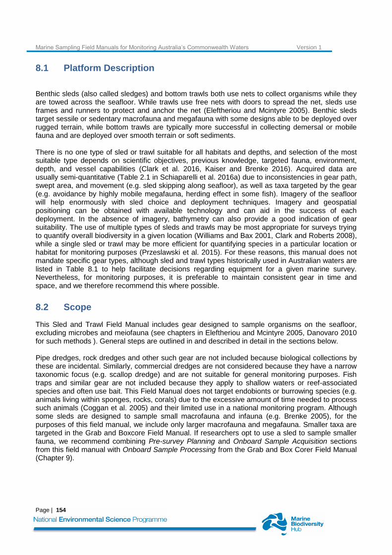
8. MARINE SAMPLING FIELD MANUAL FOR BENTHIC SLEDS AND BOTTOM TRAWLS
Rachel Przeslawski*, Franzis Althaus, Malcolm Clark, Jamie Colquhoun, Dan Gledhill, Scott Foster, Tim O’Hara
Chapter citation:. Przeslawski R, Althaus F, Clark M, Colquhoun J, Gledhill D, Flukes E, Foster S, O’Hara T, Proctor R. 2018. Marine sampling field manual for benthic sleds and bottom trawls. In Field Manuals for Marine Sampling to Monitor Australian Waters, Przeslawski R, Foster S (Eds). National Environmental Science Programme (NESP). pp. 153-171.
Marine Sampling Field Manuals for Monitoring Australia’s Commonwealth Waters Version 1
Page | 154
8.1 Platform Description
Benthic sleds (also called sledges) and bottom trawls both use nets to collect organisms while they are towed across the seafloor. While trawls use free nets with doors to spread the net, sleds use frames and runners to protect and anchor the net (Eleftheriou and Mcintyre 2005). Benthic sleds target sessile or sedentary macrofauna and megafauna with some designs able to be deployed over rugged terrain, while bottom trawls are typically more successful in collecting demersal or mobile fauna and are deployed over smooth terrain or soft sediments. There is no one type of sled or trawl suitable for all habitats and depths, and selection of the most suitable type depends on scientific objectives, previous knowledge, targeted fauna, environment, depth, and vessel capabilities (Clark et al. 2016, Kaiser and Brenke 2016). Acquired data are usually semi-quantitative (Table 2.1 in Schiaparelli et al. 2016a) due to inconsistencies in gear path, swept area, and movement (e.g. sled skipping along seafloor), as well as taxa targeted by the gear (e.g. avoidance by highly mobile megafauna, herding effect in some fish). Imagery of the seafloor will help enormously with sled choice and deployment techniques. Imagery and geospatial positioning can be obtained with available technology and can aid in the success of each deployment. In the absence of imagery, bathymetry can also provide a good indication of gear suitability. The use of multiple types of sleds and trawls may be most appropriate for surveys trying to quantify overall biodiversity in a given location (Williams and Bax 2001, Clark and Roberts 2008), while a single sled or trawl may be more efficient for quantifying species in a particular location or habitat for monitoring purposes (Przeslawski et al. 2015). For these reasons, this manual does not mandate specific gear types, although sled and trawl types historically used in Australian waters are listed in Table 8.1 to help facilitate decisions regarding equipment for a given marine survey. Nevertheless, for monitoring purposes, it is preferable to maintain consistent gear in time and space, and we therefore recommend this where possible.
8.2 Scope
This Sled and Trawl Field Manual includes gear designed to sample organisms on the seafloor, excluding microbes and meiofauna (see chapters in Eleftheriou and Mcintyre 2005, Danovaro 2010 for such methods ). General steps are outlined in and described in detail in the sections below. Pipe dredges, rock dredges and other such gear are not included because biological collections by these are incidental. Similarly, commercial dredges are not considered because they have a narrow taxonomic focus (e.g. scallop dredge) and are not suitable for general monitoring purposes. Fish traps and similar gear are not included because they apply to shallow waters or reef-associated species and often use bait. This Field Manual does not target endobionts or burrowing species (e.g. animals living within sponges, rocks, corals) due to the excessive amount of time needed to process such animals (Coggan et al. 2005) and their limited use in a national monitoring program. Although some sleds are designed to sample small macrofauna and infauna (e.g. Brenke 2005), for the purposes of this field manual, we include only larger macrofauna and megafauna. Smaller taxa are targeted in the Grab and Boxcore Field Manual. If researchers opt to use a sled to sample smaller fauna, we recommend combining Pre-survey Planning and Onboard Sample Acquisition sections from this field manual with Onboard Sample Processing from the Grab and Box Corer Field Manual (Chapter 9).
Marine Sampling Field Manuals for Monitoring Australia’s Commonwealth Waters Version 1
Page | 155
8.3 Sleds and Trawls in Marine Monitoring
Sleds and trawls can be used to successfully monitor changes in benthic communities over time (Billett et al. 2001). However, they are becoming less popular for this purpose due to their destructive sampling, difficulty in revisiting exact sites, and sampling variability due to species and size selectivity. In addition, more quantitative underwater imagery technologies continue to develop and become more accessible. Instead, sleds and trawls are now most likely to be applied in the first stage to a monitoring program as baseline data to inform imagery annotations by providing species inventories or biodiversity assessments (Przeslawski et al. 2015), particularly as related to new, endemic, or cryptic taxa. This is essential for environments and regions in which extractive sampling is the only means to examine and identify many species in complex ecosystems. The specimens themselves are used to inform taxonomic studies, ascertain species distributions, and as a source of genetic (DNA) data and isotope data. Thus their application is similar to grabs and boxcores, but sleds and trawls sample a large transect rather than a point. Therefore, they may be more suitable to assess macrofaunal biodiversity in the deep sea where light is low, species have few colour cues, abundances may be low, and deployment times are high.
8.4 Equipment
Equipment must be appropriately set-up to ensure as much consistency as possible among surveys and also to facilitate gear replacement if necessary. Equipment configurations can vary among substrate types. For example, in abyssal plains, wider skids on a beam trawl reduce sinking into mud. Table 8.1 lists the specifications, where available, of benthic sleds and trawls deployed in Australian waters. The key components for a bottom trawl include the following, all of which should be documented and photographed:
Sampling gear o Net (full net plans, including mesh types and sizes) o Floatation system (headline floatation plan, size, number, and position of floats) o Groundrope (groundrope composition, length, details of all components)
Rigging plans o Sweep and bridle size and lengths o Layback of the headline (if any)
Deployment procedures o Warp-to-depth ratios for amount of trawl wire o Standard electronics to be used, and acceptable values of certain measurements o Required towing speed
The key components for a benthic sled include:
Sampling gear o Net (full net plans, including mesh types and sizes) o Frame (full frame plan, including dimensions and weight, chafing mat) o Buoys (size, number, position) o Mouth dimensions
Rigging plans o Bridle size and lengths o Weak links
Deployment procedures o Estimated amount of trawl wire
Marine Sampling Field Manuals for Monitoring Australia’s Commonwealth Waters Version 1
Page | 156
o Standard electronics to be used, and acceptable values of certain measurements o Required towing speed
8.5 Pre-Survey Preparations
Identify a chief biologist or ecologist who will be responsible for making decisions related to samples onboard, particularly regarding prioritisation of samples during onboard processing. This will be particularly helpful during busy periods with large hauls or multiple back-to-back tows. If 24-hour operations are planned, a second-in-charge will be needed as well. Confirm sampling design meets survey objectives, is achievable with planned equipment and time, and has been communicated to all key scientists and managers. See Chapter 2 for further details on sampling design. Consideration must be given to the location of the trawl or sled during deployment. Ultra-short baseline acoustic technology (USBL) is recommended to identify the true location of the sled/trawl during bottom contact (Schlacher et al. 2007), particularly in deep waters where the sled/trawl may be kilometres away from the vessel during a tow (Clark and Stewart 2016). If a USBL is unavailable in deep waters, the angle and length of wire payed out should be recorded so that sled/trawl location can be trigonometrically estimated (Milroy 2016). Station record forms should record gear location wherever possible, with vessel location recorded as a back-up. Consideration must be given to the stability of the trawl or sled during deployment. Ideally, a Netsonde or bottom contact sensor will be used to indicate when the gear is lifting off the seafloor so that speed can be reduced or more wire payed out or retracted. With trawls, door-spread or wing-end sensors are also useful to ensure consistency of gear set-up and performance. If these are unavailable, strict attention must be paid to the winch wire and constant adjustments performed or a self-tensioning winch used to ensure continuous bottom contact (Clark et al. 2016). During the planning phases, taxonomists and museum curators must be engaged to ensure that samples will be appropriately identified and voucher specimens are lodged at national repositories (i.e. museums). They can also advise on the likely species selectivity of the proposed gear for certain taxa. Preferably, taxonomists will participate in marine surveys in which case they can identify much of their respective groups onboard (Zintzen et al. 2011). The appropriate taxonomic resolution at which specimens will be identified should also be determined. Species-level identification may be appropriate for voyages of discovery (Poore et al. 2015), while family level may be suited for measuring relationships with environmental covariates (Hirst 2006). For many surveys, identifications will only target selected groups (e.g. sponges in Przeslawski et al. 2015). This should be decided in the pre-survey planning stage, not a posteriori (i.e. during or after the survey). Importantly, non-target specimens should still be retained for museum lodgement if possible, in order to facilitate identification in the future if resources or priorities allow. The purposes of biological samples must be determined. For monitoring purposes, samples of each target species or operational taxonomic unit (OTU) must be collected for taxonomic identifications. Further objectives specific to a given survey or project may also include samples for genetic or biochemical analyses for particular groups. Protocols for these samples (including preservation as per point below) must be developed prior to the start of the survey. The level of onboard searching and sorting should be decided during the planning phase where there is sufficient information to inform discussion of likely catch rates. Onboard searching refers to the time spent looking through non-biogenic material to find biota, while onboard sorting refers to the taxonomic level to which biota are identified. Both will be determined by the key survey objectives, onboard taxonomic expertise, and available time and space. It is important that search
Marine Sampling Field Manuals for Monitoring Australia’s Commonwealth Waters Version 1
Page | 157
effort is not adjusted between deployments as this is a source of variation. Onboard sorting may vary among groups (i.e. many fish may get sorted to species while invertebrates stay in coarse groups). At a minimum, samples should be sorted onboard by phylum to ensure correct preservation and assist dissemination post-voyage, but samples should also be able to readily be subdivided for many phyla (e.g., Cnidaria, Arthropoda, Echinodermata). Taxonomists are far more likely to be willing to engage in post-survey identifications where the sample has been sorted to an appropriate level onboard Decide on preservation methods. This should be done in consultation with curators, taxonomists, molecular biologists, and biochemists that will be involved in using the samples. See Coggan et al. (2005) and Schiaparelli et al. (2016b) for information about appropriate preservatives for a range of taxa and purposes (e.g., species identification and description, genetic analysis, biochemical analysis), noting the variation between taxa. Ensure adequate risk assessments are undertaken regarding safety and use of chemical onboard (i.e. ethanol, formalin). This should include where appropriate onboard storage for chemicals, as well as personal protective gear and ventilation. Determine if specialists are needed for gear use. Many nets and sleds require experience to prepare, deploy and retrieve. The details below are not targeted for any one particular equipment or system, and we recommend engaging an experienced crew who have previously deployed similar devices. Obtain appropriate permits that may apply for collection (Appendix B). Ideally, all surveys using sled, trawls or dredges will have a permit for biological collection, even if target samples are rocks and sediments. This will ensure incidental biological specimens do not get discarded overboard. Current regulations require permits for biological material being deposited in registered institutions. For Commonwealth waters, these include
1) Australian Fisheries Management Authority “Application for Scientific Permit”
2) Parks Australia: “Application for a permit to access biological resources in Commonwealth areas”
3) Parks Australia: “Application to Conduct Research Activities Within Commonwealth Marine Reserves”
Collection ethics approval may also be required from the research institution. In addition, more focussed permits including animal ethics may be needed for particular taxa (e.g. fish and cephalopods). Permits must be considered not just for collecting activities, but also for shipping and storage (e.g., biosecurity containment facilities). For example scleractinians, antipathrians, and some fishes are regulated under the Convention on International Trade in Endangered Species, and there may be restrictions on shipping these taxa to museums or other repositories (especially overseas institutions) without a permit.
Document the specifications of all sampling gear to be used, including photographs (see Equipment). Specifications that should be documented include gear size and configuration (mesh, floats, ground ropes, frame, spread between trawl doors), rigging plans (bridle, headline layback), and deployment needs (wire length estimated, required towing speed, netsonde or USBL methods). This can assist with estimating location and area of the seafloor sampled, as well as providing crucial information for comparisons with other surveys. Where possible, the gear set-up and specifications should be standardised across all surveys using the same equipment. Decide on procedures for very large hauls. Sub-sampling or a focus on key taxonomic groups may save time needed for other survey operations (e.g. multibeam mapping) or objectives (e.g. biodiversity characterisation in different location) (Shimadzu and Darnell 2015). Alternatively, coarse
Marine Sampling Field Manuals for Monitoring Australia’s Commonwealth Waters Version 1
Page | 158
level estimation of abundances could occur based on visual estimates or case counts. Such procedures must be decided before gear deployment and remain consistent for a given survey, and in all cases, representatives of all taxa should be collected and appropriately preserved. If time permits, pilot deployments can help determine the efficiency of the gear, deployment times, suitability of terrain, catch sizes over distances, and processing times. Organise shipment of samples from vessel to repository (e.g. museum). If samples are frozen and are not too bulky, it may be most cost-effective to have individuals transport them on aircraft in which case airline requirements should be considered. If samples are in ethanol or formalin, transport of dangerous goods must be organised. Planning for shipment of samples well in advance of the survey will expedite demobilisation and ensures sample integrity. The destination museum can likely provide advice on shipping methods and regulations. See Schiaparelli et al. (2016b) for shipping advice.

Marine Sampling Field Manuals for Monitoring Australia’s Commonwealth Waters Version 1
Page | 159
8.5.1 Pre-survey checklist
Task Description/comments
□ Identify onboard chief ecologist/biologist
□ Confirm sampling design meets necessary criteria
□ Engage taxonomists and curators
□ Determine onboard sorting level
□ Determine preservation methods
□ Complete necessary risk assessments
□ Identify specialists needed for gear configuration and deployment
□ Data storage needs identified and hardware purchased accordingly
□ Decide on methods for locating gear during deployment
□ Decide on methods to assess gear stability during deployment
□ Obtain appropriate permits
□ Document gear specifications
□ Determine procedures for large hauls
□ Organise shipment of samples

Marine Sampling Field Manuals for Monitoring Australia’s Commonwealth Waters Version 1
Page | 160
8.6 Field Procedures
A visual summary of the key steps to follow when deploying benthic sleds or bottom trawls is shown in Figure 8.1.
8.6.1 Onboard sample acquisition
1. Use acoustic data or underwater imagery to confirm areas to sample with the appropriate
benthic gear (Schlacher et al. 2007, Williams et al. 2010). Do not deploy blind, as this increases
the risk of equipment loss and damage, as well as unnecessary impact on potentially vulnerable
ecosystems.
2. Brief crew and sorting staff on potential venomous or otherwise dangerous catch (i.e. cone shell,
blue-ringed octopus, some fishes, corals, sponges).
3. Ensure the gear is set-up and deployment parameters and procedures are as documented in
the gear-specific protocols.
4. Use netsonde or bottom contact sensor to ensure sled or trawl is suitably deployed along the
seafloor [Recommended]
5. Use USBL System to ensure accurate positioning (Schlacher et al. 2007, Williams et al. 2015)
[Recommended]
6. Mark sled runners or trawl groundline with waterproof pencil or paint to gauge success of
seafloor deployment. Also check for polishing on the bobbins or runners. [Recommended]
7. Record all metadata related to a given tow, specified in Table 8.2.
8. For rugged slopes (e.g. seamounts), ensure appropriate gear is used and tow downslope to
reduce snags.
9. Maintain speed that is appropriate for the gear and seafloor terrain. Epibenthic sleds and most
beam and Agassiz trawls should be towed at 1–2 knots to maintain bottom contact, while faster
speeds of 3–3.5 knots are appropriate for otter trawls and other gear dependent on speed to
maintain net spreading. See Clark et al. 2016 and Kaiser and Brenke 2016 for details.
10. Tow into the swell, tide, current and/or wind so that vessel speed and steerage can be better
controlled.
11. We are unable to set a standard required tow distance (i.e. bottom time) for monitoring purposes
because tow distance is highly dependent on gear type and seafloor environment. However,
within a given survey, tow distance for each sled or trawl should be standardised to assess
relative abundances. It should also be recorded in the metadata (Table 8.2). If the same sled is
used on multiple surveys in similar environments, the tow distance should remain the same so
that spatiotemporal comparisons can be made. For benthic sleds deployed along the continental
shelf over mixed terrain, a tow distance of ~100 m is recommended. Longer tows will be
needed (commonly 300 m) in deep waters due to lower density of macro- and megafauna.
Information from multibeam data (see point 1) can help inform tow duration decisions.

Marine Sampling Field Manuals for Monitoring Australia’s Commonwealth Waters Version 1
Page | 161
12. Assess success of deployment. If there is significant damage to gear, signs of minimal bottom
contact, or ripped nets, this should be recorded in the metadata (Table 8.2). The catch from
such deployments should be considered only for presences-only analyses, species inventories
or biological analyses but should not be used for quantitative comparisons with other tows. In
such situations, gear configuration should also be checked after recovery to ensure its correct
specification for the next deployment (see point 3).
13. When the sled or trawl is lifted from the water, follow gear- and vessel-specific protocols for safe
release of the catch onto the deck or sorting table.
14. Record biomass of entire catch using electronics from winch system or onboard scale
[Recommended]
15. Photograph entire catch with station identification placard and make notes of catch composition
(e.g. lots of mud or rocks) in metadata sheet (Table 8.2).
16. Remove all animals from the entire net, including the fore-parts of nets and sleds and not just
the codend where most of the catch should have been collected. As soon as practical, begin
onboard processing of the samples (next section).
17. Clean sled of all material and prepare for next deployment.
8.6.2 Onboard sample processing
1. For very large catches, implement sub-sampling protocol if applicable (see Pre-Survey
Preparations).
2. Consider retaining material on ice or in an ice slurry while awaiting sorting to ensure material
remains in best condition to assist accurate and consistent identification.
3. Separate large easily visible taxa into sorting trays by coarse groups: fish, sponges, soft corals,
echinoderms, molluscs, ascidians, bryozoans, annelids, other. Weigh each group. Discard
severely damaged organisms and non-biogenic material, unless otherwise needed. It can be
useful to record the weights, descriptions, and images of rock, coral rubble and other non-
biogenic material as this gives useful information on substrate type. Add a label to each sorting
tray with Tow ID so as to avoid confusion when multiple tows are being processed.
4. Follow Animal Ethics procedures to euthanize animals where applicable
5. Place fragile organisms in seawater in the sorting trays. Use chilled seawater for deep-sea and
polar samples to minimise sample degradation during sorting time.
6. Transfer groups to the sorting station, if not already there. See Coggan et al. (2005) for practical
advice on setting up a sorting station.
7. Based on previous decisions about onboard level of sorting (Section 8.5), progressively sort
organisms into finer taxonomic groups, as much as time or expertise allow, with OTU
(operational taxonomic unit) or species representing the finest taxonomic level.
Marine Sampling Field Manuals for Monitoring Australia’s Commonwealth Waters Version 1
Page | 162
8. Weigh, count, and photograph each of the final groups, including a scale bar and unique
identifying sample number. Refer to Schiaparelli et al. 2016 for suggestions on specimen
photography.
9. Record data against a unique station identifier for the data base and keep a label with the same
unique identifier with the specimen(s) (Table 8.3). At this stage identify specimens (or subset of
specimens) for analyses purposes (whole specimens for taxonomy/ isotopes/genetics etc.) or
where appropriate (and pre-determined in plan) take tissue samples for analyses (genetics
isotopes etc.) If there are large numbers of the same species or OTU, only a sub-set may need
to be preserved for museum collections; this should be established during Pre-Survey Planning
in consultation with taxonomists or curators. In this case, record the total number collected as
well as the number in the collection container.
10. If applicable relax and fix specimens according to survey objectives and taxonomists’
preferences (e.g. samples for genetic analysis should not be fixed in formalin).
11. Preserve specimen according to methods decided in Pre-Survey Preparations, and place into
container. See Rees (2009) and Schiaparelli et al. (2016b) for comprehensive description of
fixatives and preservatives used for marine invertebrates.
12. Place solvent-hardy label with unique identifier in each sample container. It is not sufficient to
label only the outside of the container, as this can easily rub off. See Box 15.6 in Schiaparelli et
al. 2016 for suitable label characteristics.
13. Place container in large sealable container (i.e. lidded drum) with other samples preserved using
the same chemicals (e.g. ethanol) or method (e.g. freezing). It saves time in post-survey sample
distribution if taxa are grouped together in containers rather than by station.
8.6.3 Onboard sample storage
1. Store large labelled drum onboard in the freezer or in an approved storage area for hazardous
chemicals.
2. Transcribe metadata from Tables 8.2 and 8.3 into digital format as soon as possible to minimise
the build-up of data entry. This must be done onboard preferably during the same shift because
it provides a back-up and an immediate check of the record, as well as facilitating timely
metadata release.
3. Check the data entry is correct by cross-checking field sheets with database. This is best done
by the person who didn’t enter the data [Recommended].
4. During demobilisation, ensure samples and drums are properly labelled and closed, and
implement shipping according to decision made during pre-survey planning.

Marine Sampling Field Manuals for Monitoring Australia’s Commonwealth Waters Version 1
Page | 163
8.7 Post-survey procedures
8.7.1 Sample curation
1. Lodge all specimens in an internationally recognised and routinely maintained specimen
collection (e.g. museum) for curation and public accessibility [Recommended].
2. If all specimens are unable to be lodged at a museum due to lack of resources or need for
destructive analyses (e.g. biochemical analyses), voucher specimens must be lodged (i.e. at
least one animal per OTU).
8.7.2 Data release
Traditionally, data related to biological specimens have been delivered as presence-only taxonomic identifications. These are often managed by individual museum scientists or curators and subsequently harvested by the Atlas of Living Australia (ALA) and the Ocean Biogeographic Information System (OBIS). These portals do not yet include absences or information related to sampling effort, thus reducing the applicability of such database to monitoring purposes. There are current initiatives underway that aim to incorporate species presence data to more ecologically relevant applications. For example, OBIS International manages a project called OBIS-ENV-DATA that extends data structures to allow linking species data to other related data (environmental, images, sampling effort) (De Pooter et al. 2017). In the meantime, the steps listed below will ensure appropriate and timely release of both metadata and data: 1. Create a metadata record describing the data collection. Provide as much detail as possible on
the collection/deployment (either directly in the metadata record itself, or in the form of attached
field sheets as .csv, .txt or similar). This should include sampling locations and dates, equipment
used, level of sorting applied, etc. All collection/deployment information must be QC-d before
inclusion.
2. Publish metadata record(s) to the Australian Ocean Data Network (AODN) catalogue as soon as
possible after metadata has been QC-d. This can be done in one of two ways:
a. If metadata from your agency is regularly harvested by the AODN, follow agency-specific protocols for metadata and data release.
b. Otherwise, metadata records can be created and submitted via the AODN Data Submission Tool. Note that this tool requires user registration, but this is free and immediate.
This step provides immediate documentation of the methods and location of the collection of
biological material. This stage may also include links to field reports or data sheets.
3. Produce a technical or post-survey report documenting the purpose of the survey, survey
design, sampling locations, sampling equipment specifications, and any challenges or limitations
encountered (Appendix C). Provide links to this report in all associated metadata records
[Recommended]
4. Complete the species identifications and associated abundance or biomass for targeted groups
identified. This can take quite some time, depending on sample size and available resources. It
is not unusual for taxonomic identifications to lag years behind survey completion, but this
should not delay publication of initial metadata and deployment information. Care must be taken
Marine Sampling Field Manuals for Monitoring Australia’s Commonwealth Waters Version 1
Page | 164
to ensure consistent nomenclature is used and documented for undescribed or unnamed
species (e.g. defined Operational Taxonomic Units, OTUs). Ideally photographic catalogues of
OTUs are established such that subsequent surveys may use consistent OTU classification,
thereby ensuring comparability of data between surveys.
5. QC the data. This includes checking for spelling errors, missing data, consistent nomenclature
and use of OTUs, and confirmation that outliers are not data entry errors (e.g. 100 individuals
really were collected, not just 10).
6. Attach or link the full data spreadsheet (including absences and abundances/biomass) to the
metadata record previously created and published to the AODN. This will ensure public
discoverability and accessibility of the complete data, including absences.
8.8 Field Manual Maintenance
In accordance with the universal field manual maintenance protocol described in Chapter 1 of the Field Manual package, this manual will be updated in 2018 as Version 2. Updates will reflect user feedback and new developments (e.g. data discoverability and accessibility). Version 2 will also detail subsequent version control and maintenance. The version control for Chapter 8 (field manual for sleds and trawls) is below:
Version Number
Description Date
0 Submitted for review (NESP Marine Hub, GA, external reviewers as listed Appendix A.
22 Dec 2017
1 Publicly released on www.nespmarine.edu 28 Feb 2018
2 Relevant updates, including Data Release sections based on NESP, AODN, IMOS, GA, and CSIRO projects
Early 2019

Marine Sampling Field Manuals for Monitoring Australia’s Commonwealth Waters Version 1
Page | 165
Figure 8.1 Images from key steps involved in the use of benthic sleds and bottom trawls for marine monitoring: a) a modified WHOI sled with attached pipe dredges, b) seafloor imagery
from towed video and bathymetric grids, c) lowering the AIMS benthic sled, d) sorting animals on the back deck, e) photographing specimens in ship laboratory, f) securely sealed
containers to ship animals to museums
Marine Sampling Field Manuals for Monitoring Australia’s Commonwealth Waters Version 1
Page | 166
Table 8.1 Types of benthic sleds and trawls deployed in Australian waters and their associated characteristics. See reviews on benthic sleds and trawls for information about gear
deployed elsewhere in the world (Clark et al. 2016, Kaiser and Brenke 2016).
Type Dimensions
(mouth, h x w)
Weight Target taxa Cod end Other features Suitable terrain Ref
Sherman (CSIRO-
SEBS) sled
600 X 1200 mm 860 kg (excluding
modifications from
Lewis 2009)
Benthic
invertebrates and
fish
Polyethylene twine,
3.2 m long, 25 mm
mesh
Reinforced frame,
weak link chains,
chaffing mat, net
sonde, optional
infaunal or 1 mm net
Seamount,
rugged terrain,
hard substrates
(Lewis 1999, 2009)
Rainer sled 2900 mm width 590 kg Benthic
invertebrates
25 mm stretch mesh
Sled divided into
epibenthic and infaunal
halves
Various shelf
substrates
(Bax et al. 1999)
AIMS sled 1500 x 1000 mm Large benthic
invertebrates
45 mm stretch
diamond
Various shelf
substrates
(Colquhoun et al.
2007)
SARDI sled 600 x 1800 Sessile and
sedentary
epibenthos
50 mm mesh Soft sediment
shelf ecosystems
(Ward et al. 2006)
NIWA seamount
sled
1130 x 380 400 kg Sessile and
sedentary
epibenthos
28 mm Reinforced frame,
weak link chains,
location beacon, anti-
chafing net, smaller
model available (250
kg)
Seamount,
rugged terrain,
hard substrates
(Clark and Stewart
2016)
Brenke Sledge
(MNF)
1.3 m wide, 1.24 m
high
Benthic macrofauna 0.5 mm mesh Dual nets, nodule
exclusion mesh,
insulated cod end
Smooth terrain (Brenke 2005)
MAPS sled Concurrent
planktobenthic and
(Przeslawski and
McArthur 2009)
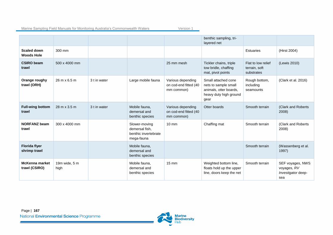
Marine Sampling Field Manuals for Monitoring Australia’s Commonwealth Waters Version 1
Page | 167
benthic sampling, tri-
layered net
Scaled down
Woods Hole
300 mm Estuaries (Hirst 2004)
CSIRO beam
trawl
500 x 4000 mm 25 mm mesh Tickler chains, triple
tow bridle, chaffing
mat, pivot points
Flat to low relief
terrain, soft
substrates
(Lewis 2010)
Orange roughy
trawl (ORH)
26 m x 6.5 m 3 t in water Large mobile fauna Various depending
on cod-end fitted (40
mm common)
Small attached cone
nets to sample small
animals, otter boards,
heavy duty high ground
gear
Rough bottom,
including
seamounts
(Clark et al. 2016)
Full-wing bottom
trawl
28 m x 3.5 m 3 t in water Mobile fauna,
demersal and
benthic species
Various depending
on cod-end fitted (40
mm common)
Otter boards Smooth terrain (Clark and Roberts
2008)
NORFANZ beam
trawl
300 x 4000 mm Slower-moving
demersal fish,
benthic invertebrate
mega-fauna
10 mm Chaffing mat Smooth terrain (Clark and Roberts
2008)
Florida flyer
shrimp trawl
Mobile fauna,
demersal and
benthic species
Smooth terrain (Wassenberg et al.
1997)
McKenna market
trawl (CSIRO)
19m wide, 5 m
high
Mobile fauna,
demersal and
benthic species
15 mm Weighted bottom line,
floats hold up the upper
line, doors keep the net
Smooth terrain SEF voyages, NWS
voyages, RV
Investigator deep-
sea
Marine Sampling Field Manuals for Monitoring Australia’s Commonwealth Waters Version 1
Page | 168
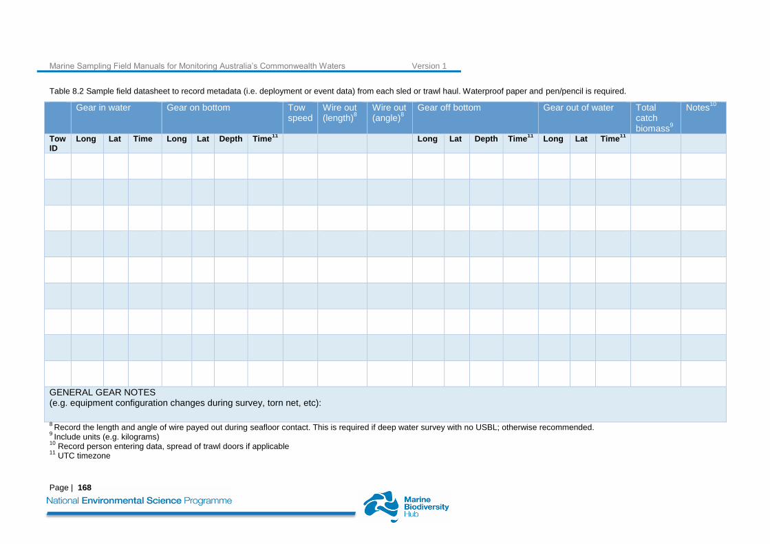
Table 8.2 Sample field datasheet to record metadata (i.e. deployment or event data) from each sled or trawl haul. Waterproof paper and pen/pencil is required.
Gear in water Gear on bottom Tow speed
Wire out (length)
8
Wire out (angle)
8
Gear off bottom Gear out of water Total catch biomass
9
Notes10
Tow ID
Long Lat Time Long Lat Depth Time11
Long Lat Depth Time11
Long Lat Time11
GENERAL GEAR NOTES (e.g. equipment configuration changes during survey, torn net, etc):
8 Record the length and angle of wire payed out during seafloor contact. This is required if deep water survey with no USBL; otherwise recommended.
9 Include units (e.g. kilograms)
10 Record person entering data, spread of trawl doors if applicable
11 UTC timezone

Marine Sampling Field Manuals for Monitoring Australia’s Commonwealth Waters Version 1
Page | 169
Table 8.3 Sample field datasheet to record metadata from each sorted biological sample. Waterproof paper and pen/pencil is required.
Tow ID
Sample ID
Phylum Class Order Family Genus, Species / Common Name
Weight Abundance Preservative / Quantity
Photos Notes
Marine Sampling Field Manuals for Monitoring Australia’s Commonwealth Waters Version 1
Page | 170
8.9 References
Bax, N., R. Kloser, A. Williams, K. Gowlett-Holmes, and T. Ryan. 1999. Seafloor habitat definition for spatial management in fisheries: a case study on the continental shelf of southeast Australia. Oceanologica Acta 22:705-720.
Billett, D. S. M., B. J. Bett, A. L. RIce, M. H. Thurston, J. Galeron, M. Sibuet, and G. A. Wolff. 2001. Long-term change in the megabenthos of the Porcupine Abyssal Plain (NE Atlantic). Progress in Oceanography 50:325-348.
Brenke, N. 2005. An epibenthic sledge for operations on marine soft bottom and bedrock. Marine Technology Society Journal 39:10-19.
Clark, M. R., N. W. Bagley, and B. Harley. 2016. Trawls. Pages 126-158 in M. R. Clark, M. Consalvey, and A. A. Rowden, editors. Biological Sampling in the Deep Sea. Wiley Blackwell, West Sussex.
Clark, M. R. and C. D. Roberts. 2008. Fish and Invertebrate Biodiversity on the Norfolk Ridge and Lord Howe Rise, Tasman Sea (NORFANZ voyage, 2003).
Clark, M. R. and R. Stewart. 2016. The NIWA seamount sled: An effective epibenthic sledge for sampling epifauna on seamounts and rough seafloor. Deep Sea Research Part I: Oceanographic Research Papers 108:32-38.
Coggan, R., M. Curtis, S. Vize, C. James, S. Passchier, A. Mitchell, C. J. Smit, B. Foster-Smith, J. White, S. Piel, and J. Populus. 2005. Review of standards and protocols for seabed habitat mapping. Mapping European Seabed Habitats, France, UK.
Colquhoun, J., A. Heyward, M. Rees, E. Twiggs, F. McAllister, and P. Speare. 2007. Ningaloo Reef Marine Park Deepwater Benthic Biodiversity Survey: Metadata Report - Number 2. Australian Institute of Marine Science.
Danovaro, R. 2010. Methods for the Study of Deep-Sea Sediments, their Functioning and Biodiversity. CRC Press, Boca Raton, Florida.
De Pooter, D., W. Appeltans, N. Bailly, S. Bristol, K. Deneudt, M. Eliezer, E. Fujioka, A. Giorgetti, P. Goldstein, M. Lewis, M. Lipizer, K. Mackay, M. Marin, G. Moncoiffé, S. Nikolopoulou, P. Provoost, S. Rauch, A. Roubicek, C. Torres, A. van de Putte, L. Vandepitte, B. Vanhoorne, M. Vinci, N. Wambiji, D. Watts, E. Klein Salas, and F. Hernandez. 2017. Toward a new data standard for combined marine biological and environmental datasets - expanding OBIS beyond species occurrences. Biodiversity Data Journal 5:e10989.
Eleftheriou, A. and A. Mcintyre. 2005. Methods for the Study of Marine Benthos, 3rd Edition. Blackwell Publishing, Oxford. Hirst, A. J. 2004. Broad-scale environmental gradients among estuarine benthic macrofaunal assemblages of south-
eastern Australia: implications for monitoring estuaries. Marine and Freshwater Research 55:79-92. Hirst, A.J., 2006. Influence of taxonomic resolution on multivariate analyses of arthropod and macroalgal reef
assemblages. Mar Ecol-Prog Ser 324, 83-93. Kaiser, S. and N. Brenke. 2016. Epibenthic Sledges. Pages 184-206 in M. R. Clark, M. Consalvey, and A. A. Rowden,
editors. Biological Sampling in the Deep Sea. Wiley Blackwell, West Sussex. Lewis, M. 1999. CSIRO-SEBS (seamount, epibenthic sampler), a new epibenthic sled for sampling seamounts and other
rough terrain. Deep Sea Research 46:1101-1107. Lewis, M. 2009. Sherman the epibenthic sled for rough terrain. CSIRO Hobart. Lewis, M. 2010. The CSIRO 4m Beam Trawl. CSIRO Marine and Atmospheric Research, Hobart. Milroy, S. P. 2016. Field Methods in Marine Science. Garland Science. Poore, G.B., Avery, L., Błażewicz-Paszkowycz, M., Browne, J., Bruce, N., Gerken, S., Glasby, C., Greaves, E., McCallum,
A., Staples, D., Syme, A., Taylor, J., Walker-Smith, G., Warne, M., Watson, C., Williams, A., Wilson, R., Woolley, S., 2015. Invertebrate diversity of the unexplored marine western margin of Australia: taxonomy and implications for global biodiversity. Marine Biodiversity 45, 271-286.
Przeslawski, R., B. Alvarez, J. Kool, T. Bridge, M. J. Caley, and S. Nichol. 2015. Implications of sponge biodiversity patterns for the management of a marine reserve in northern Australia. PLOS ONE.
Przeslawski, R. and M. McArthur. 2009. Novel method to concurrently sample the planktobenthos and benthos. Limnology and Oceanography Methods 7:823-832.
Rees, H. L., editor. 2009. Guidelines for the Study of the Epibenthos of Subtidal Environments. International Council for the Exploration of the Sea, Denmark.
Schiaparelli, S., A. A. Rowden, and M. R. Clark. 2016a. Deep-Sea Fauna. Pages 16-35 in M. R. Clark, M. Consalvey, and
A. A. Rowden, editors. Biological Sampling in the Deep Sea. Wiley Blackwell, Oxford. Schiaparelli, S., K. Schnabel, B. Richer de Forges, and T.-Y. Chan. 2016b. Sorting, recording, presevation and storage of
biological samples. Pages 338-367 in M. R. Clark, M. Consalvey, and A. A. Rowden, editors. Biological Sampling in the Deep Sea. Wiley Blackwell, West Sussex.
Schlacher, T. A., M. A. Schlacher-Hoenlinger, A. Williams, F. Althaus, J. N. A. Hooper, and R. Kloser. 2007. Richness and distribution of sponge megabenthos in continental margin canyons off southeastern Australia. Marine Ecology-Progress Series 340:73-88.
Shimadzu, H. and R. Darnell. 2015. Attenuation of species abundance distributions by sampling. Royal Society Open Science 2.
Stocks, K. I., N. J. Stout, and T. M. Shank. 2016. Information management strategies for deep-sea biology. Pages 368-385 Biological Sampling in the Deep Sea. Wiley Blackwell, West Sussex.
Ward, T. M., S. J. Sorokin, D. R. Currie, P. J. Rogers, and L. J. McLeay. 2006. Epifaunal assemblages of the eastern Great Australian Bight: Effectiveness of a benthic protection zone in representing regional biodiversity. Continental Shelf Research 26:25-40.

Marine Sampling Field Manuals for Monitoring Australia’s Commonwealth Waters Version 1
Page | 171
Wassenberg, T. J., S. J. M. Blaber, C. Y. Burridge, D. T. Brewer, J. P. Salini, and N. Gribble. 1997. The effectiveness of fish and shrimp trawls for sampling fish communities in tropical Australia. Fisheries Research 30:241-251.
Williams, A., F. Althaus, P. Dunstan, G. C. B. Poore, N. J. Bax, R. J. Kloser, and F. R. McEnnulty. 2010. Scales of habitat heterogeneity and megabenthos biodiversity on an extensive Australian continental margin (100 - 1100 m depths). Marine Ecology: An Evolutionary Perspective 31:222-236.
Williams, A., F. Althaus, and T. A. Schlacher. 2015. Towed camera imagery and benthic sled catches provide different views of seamount benthic diversity. Limnology and Oceanography: Methods 13:62-73.
Williams, A. and N. J. Bax. 2001. Delineating fish-habitat associations for spatially based management: an example from the south-eastern Australian continental shelf. Marine and Freshwater Research 52:513-536.
Zintzen, V., C. D. Roberts, M. R. Clark, A. Williams, F. Althaus, and P. R. Last. 2011. Composition, distribution and regional affinities of the deepwater ichthyofauna of the Lord Howe Rise and Norfolk Ridge, south-west Pacific Ocean. Deep Sea Research Part II: Topical Studies in Oceanography 58:933-947.