Embed Size (px)
Citation preview

8.10 Traffic and TransportationThis section presents the potential effects of the Metcalf Energy Center (MEC) on the transportation system, including any necessary modifications to the transportation system and increase in traffic from construction and operation of the proposed power plant. A description of the existing transportation system and levels of service (LOS) are presented, along with an analysis of potential impacts.Section 8.10.1 discusses the existing environmental setting; Section 8.10.2 discusses the environmental effects of construction and subsequent operation; Section 8.10.3 describes the cumulative impacts; Section 8.10.4 includes any proposed mitigation measures during construction and operation; Section 8.10.5 presents applicable laws, ordinances, regulations and standards (LORS); and Section 8.10.6 contains references.
8.10.1 Affected Environment8.10.1.1 Highways and RoadsThe MEC site is located in the North Coyote Valley, which lies between the southernmost part of San Jose and Morgan Hills, located 8 miles to the south (see Figure 8.10-1). As illustrated in Figure 8.10-2, the major north-south roads in the area of the project site are Monterey Road, Santa Teresa Boulevard, U.S. 101, and State Route (SR) 85.Monterey Road (also designated as SR 82) is the former route of U.S. 101. It passes through San Jose to the north of the MEC site and continues south through Gilroy. It runs parallel to and between the UPRR ROW and U.S. 101. Monterey Road is classified as a four-lane divided arterial by San Jose and as an Arterial Primary Urban (APU) by Santa Clara County for the portion of Monterey Road that is in its jurisdiction. The road has 12- to 13-foot wide lanes, 6-foot paved shoulders, and left-turn lanes. The posted speed limit along Monterey Road is 50 miles per hour (mph). Within the vicinity of the MEC project, Monterey Road intersects with Metcalf Road and Bailey Avenue.Santa Teresa Boulevard extends from San Jose to the north past the MEC site for a distance of about 2 miles where it changes name to Hale Avenue. It is located to the west of the MEC site, and connects to Bernal Road approximately one and one half miles north of the site (providing access to U.S. 101) and to Bailey Avenue approximately two miles south of the site. Santa Teresa Boulevard is classified as a two- to four-lane minor arterial by San Jose and as APU by Santa Clara County over that portion south of the project. Santa Teresa Boulevard has 12- to 14-foot-wide lanes, left-turn pockets, a 48-foot median, 9-foot paved shoulders, and striped and signed bike lanes. The posted speed limit on Santa Teresa Boulevard ranges from 45 to 50 mph.Blanchard Road is a private road located about 3/4 mile south of Metcalf Road. There is a traffic light at the intersection. The proposed access road to the MEC site would connect to Blanchard Road just west of the UPRR ROW.
SAC/150038/011R.DOC 8.10-1REV. 6-3-99

U.S. 101 provides north-south regional access and extends almost the entire length of California, from beyond the California-Oregon border to Los Angeles. Within Santa Clara County, U.S. 101 crosses through eastern San Jose to the east, and connects with State Routes 85, 237, 87, 130 East, 82 North, 152, and 25 East, and Interstates 880, 680 North, and
SAC/150038/011R.DOC 8.10-2REV. 6-3-99

280 West. U.S. 101 is a 5- to 8-lane limited access freeway that narrows to 4 lanes north of Bernal Road (about 1-1/2 miles north of the site) and continues about 6-1/2 miles south before it widens to 6 lanes. The posted speed limit on U.S. 101 is 65 mph.SR 85, known locally as the West Valley Freeway, intersects U.S. 101 in the vicinity of Bernal Road. From its intersection with U.S. 101, it extends west and then north to serve the western part of the Santa Clara Valley, intersecting again with U.S. 101 in Mountain View. SR 85 connects to SR 87, a major north/south freeway through San Jose. SR 85 is classified as a 4-lane freeway (with two more high-occupancy vehicle lanes). It has a posted speed limit of 65 mph.Major east/west roads in the area of the project site include Bernal Road and Bailey Avenue. Bernal Road extends between U.S. 101 and Santa Teresa County Park and Golf Club. It is a 4-lane arterial. Bernal Road has 12-foot wide lanes, a median and 5-foot sidewalks. The posted speed limit is 40 mph. Bailey Avenue extends about 2 miles west from Monterey Road until its terminus at McKean Road in the vicinity of Calero Reservoir County Park. The road intersects Santa Teresa Boulevard about 1/2 mile west of Monterey Road. It is classified as a 2-lane arterial. Bailey Avenue has 12-foot wide lanes and 6-foot paved shoulders. The posted speed limit is 45 mph.
8.10.1.2 Truck Routes, Weight and Load LimitationsAccording to the San Jose Streets and Traffic Department, there are no weight and load limits on any of the roads within the vicinity of the project area (Eychner, 1999). As stated in the San Jose 2020 General Plan (1994), truck traffic is encouraged to use state freeways, county expressways, and 6-lane arterials and to use routes that have the least adverse impact on residential areas. Truck travel on neighborhood streets should be minimized, and freight loading and unloading should not occur on public streets.The California Department of Transportation (Caltrans) weight and load limitations for state highways apply to all state and local roadways. According to the California Highway Patrol (CHP), U.S. 101 is a national highway network route that any legal truck can use, even if it exceeds the California length limitation of 65 feet. Operational restrictions exist on SR 85 (Little, 1999). The weight and load limitations are specified in the California Vehicle Code Sections 35550 to 35559. The following provisions, from the California Vehicle Code, apply to all roadways and are therefore applicable to this project.General Provisions: The gross weight imposed upon the highway by the wheels on any axle of a
vehicle shall not exceed 20,000 pounds and the gross weight upon any one wheel, or wheels, supporting one end of an axle, and resting upon the roadway, shall not exceed 10,500 pounds.
The maximum wheel load is the lesser of the following: a) the load limit established by the tire manufacturer, or b) a load of 620 pounds per lateral inch of tire width, as determined by the manufacturer’s rated tire width.
Vehicles with Trailers or Semitrailers:
SAC/150038/011R.DOC 8.10-3REV. 6-3-99

The gross weight imposed upon the highway by the wheels on any one axle of a vehicle shall not exceed 18,000 pounds and the gross weight upon any one wheel, or wheels, supporting one end of an axle and resting upon the roadway, shall not exceed
9,500 pounds, except that the gross weight imposed upon the highway by the wheels on any front steering axle of a motor vehicle shall not exceed 12,500 pounds.
The San Jose Streets and Transportation Department estimates citywide truck traffic to average 5 percent of total vehicular traffic (Martarano, 1999). Truck traffic is estimated to be 1 percent of total traffic on Santa Teresa Boulevard, 5 percent on Bernal Road and Bailey Avenue, and 12 percent on Monterey Road. According to the State of California report, “1997 Annual Average Daily Truck, Traffic on the California State Highway System” (Caltrans 1999), the percentage of trucks on U.S. 101 is 5.5 percent of total traffic north of SR 85 and 3.6 percent south of SR 85. West of U.S. 101, the percentage of trucks to cars on SR 85 is 7.5 percent.
8.10.1.3 Traffic VolumesTable 8.10-1 summarizes the 1998 roadway traffic conditions in the project vicinity. The table includes existing classification, LOS threshold, design capacity, daily volume, peak hour volume, and LOS. The LOS concept uses qualitative measures that characterize operational conditions within a traffic stream. Levels of service are defined and given letters from A to F, with LOS A representing the best operating conditions and LOS F the worst. The p.m. peak hour (4 p.m.- 6 p.m.) versus a.m. peak hour (7 a.m.- 9 a.m.) is assumed to be the period in which the maximum amount of traffic is experienced. LOS was determined based on the 1994 Highway Capacity Manual as recommended in “Transportation Impact Analysis Guidelines” (Santa Clara Valley Transportation Authority, 1998). Roadway design capacity represents the maximum vehicles per day that the roadway can serve. Daily volumes represent the 1998 Average Daily Traffic (ADT) counts in both directions of travel. TABLE 8.10-11998 Conditions of Affected Roadways
Street Segment ClassificationNo. of Lanes
Average Daily
Volume1
Hourly LOS D
Threshold2
Hourly Design
Capacity3
PM Peak Hour
Volume4 LOSSanta Teresa Boulevard Minor ArterialBernal Road/Avenida Espana 2
412,530 1,240
2,8002,3904,000
1,255 DA
Avenida Espana/South of Bailey Avenue 2 7,500 1,240 2,390 750 CMonterey Road ArterialBernal Road/South of Bailey Avenue 4 22,575 3,300 4,400 3,090 CBailey Avenue Minor ArterialSanta Teresa Blvd./Monterey Road 2 5,910 1,240 2,010 590 CBernal Road ArterialMonterey Road/Via del Oro 4 20,575 2,540 3,680 2,060 BVia del Oro/Realm Drive 4 24,425 2,540 3,680 2,440 CRealm Drive/Santa Teresa Blvd. 4 22,720 2,540 3,680 2,270 CU.S. 101 North of Bernal Road Freeway 5
877,770 7,800
12,48011,30018,400
6,360 CB
Bernal Road/Cochrane Road 4 86,860 6,240 8,800 7,170 DSR 85
SAC/150038/011R.DOC 8.10-4REV. 6-3-99

TABLE 8.10-11998 Conditions of Affected Roadways
Street Segment ClassificationNo. of Lanes
Average Daily
Volume1
Hourly LOS D
Threshold2
Hourly Design
Capacity3
PM Peak Hour
Volume4 LOSU.S. 101/Bernal Road Freeway 4 28,280 6,240 8,800 2,980 BWest of Bernal Road 4 43,935 6,240 8,800 4,495 C
Source:1 Estimated number of vehicles per day both directions. Based on Caltrans 1997 Traffic Volumes and County of Santa Clara 1994 to 1998 traffic counts.2 Maximum number of vehicles per hour both directions for LOS D. 3 Maximum number of vehicles per hour both directions for LOS F.4 Vehicles per hour in both directions.
According to state law, all urbanized counties in California must prepare and monitor the implementation of a Congestion Management Program (CMP). Santa Clara County’s CMP is overseen by the Santa Clara Valley Transportation Authority. The County of Santa Clara and cities within are required to implement a deficiency plan whenever transportation facilities under their jurisdiction, which are part of the CMP roadway system, operate below, or are expected to operate below, the adopted LOS standards. San Jose is part of the CMP and has adopted CMP agency requirements (San Jose 2020 General Plan). The Santa Clara County CMP states that LOS D is to be achieved whenever practical and LOS E threshold represents the maximum vehicles per day that the roadway can serve and still meet the minimum acceptable standard on the CMP roadway system (Santa Clara County, 1994). Figure 8.10-3 presents existing daily and peak hour traffic volumes on the major roadways.Based on Caltrans 1998 traffic counts, average daily traffic on U.S. 101 and SR 85 is estimated at 77,770 vehicles per day to the north of Bernal Road; 28,280 to the east; 86,860 to the south; and 43,935 to the west. As described in Table 8.10-1, only two segments of roadways in the project vicinity (a segment of Santa Teresa Blvd and the 4-lane section of U.S. 101) area currently experience a daily LOS D. All other segments are experiencing a LOS of C or better meeting or exceeding the CMP minimum standard.
8.10.1.4 Accident RatesAccidents are generally expressed in terms of accident rate, where accident occurrence is indexed to the amount of traffic using a given roadway. For roadway segments, accident rates are computed as the number of accidents per million vehicle-miles of travel (MVM). The number of accidents reported in the project vicinity and accident rates for selected roadways are presented in Table 8.10-2.
TABLE 8.10-2Accident History
Roadway SectionNumber of Accidents Accident Rate
3-Year Total Average Per Year MVMSanta Teresa Boulevarda
Bernal Road/Avenida EspanaAvenida Espana/South of Bailey Avenue
529
210
0.41.8
Monterey Roada Bernal Road/South of Bailey Avenue 23 8 0.3Bernal Roada Monterey/Via del Oro 28 10 1.3
SAC/150038/011R.DOC 8.10-5REV. 6-3-99

Via del Oro/Santa Teresa Blvd. 10 4 0.5Bailey Avenuea Santa Teresa Blvd./Monterey Road 6 2 0.6U.S. 101b Within San Jose City limits 3,528 1,176 0.97SR 85a U.S. 101/Bascom Avenue 761 254 0.79aSan Jose 1/96 to 11/98 (Street and Traffic Department. 1999)]bCaltrans 8/95 to 7/98 (Caltrans, 1998)
The 1997 Accident Data on State Highways (Caltrans, 1998) indicates an average statewide accident rate of 1.4 to 1.6 MVM for the type of roadway corresponding to Santa Teresa Boulevard; 1.6 MVM for the type of roadway corresponding to Monterey Road and Bernal Road; and 0.8 MVM for type of roadway corresponding to Bailey Road. The statewide average accident rate on state routes corresponding to SR 85 is 1.2 MVM, and to U.S. 101 is 1.1 MVM. Santa Teresa Boulevard experiences a higher than average accident rate in the project vicinity while all other roadways experience a lower than average accident rate.
8.10.1.5 Transportation ImprovementsThe North Coyote Valley is framed by the Santa Teresa Hills along its western edge, Tulare Hill to the north and the Silver Creek Hills to the northeast. Development of an industrial campus is planned for an area south of the MEC site. The Master Development Plan and Guidelines for the North Coyote Valley Campus Industrial Area (1985) (Master Develop Plan) sets forth the general planning criteria for such developments. Development of the North Coyote Valley would create a working, business, and recreational environment for more than 50,000 people when completed. Transportation improvements to support development would include new roadways, additional capacity on Santa Teresa Boulevard and Bailey Avenue, and new connections to U.S. 101. As shown in Figure 8.10-4, under the Master Development Plan construction of a new roadway, Coyote Valley Parkway, and four new arterials are projected. Coyote Valley Parkway and Bailey Avenue would connect to U.S. 101.Under the Master Development Plan, Coyote Valley Parkway would extend from U.S. 101 to south of Bailey Avenue, following Fisher Creek south, to the west of Santa Teresa Boulevard. It would cross over Monterey Road, and cross Santa Teresa Boulevard, Bailey Avenue, and the new arterials at-grade. Coyote Valley Parkway is planned as a 4-lane limited access road, with a 35- to 60-foot median, and 6-foot pedestrian path. Santa Teresa Boulevard and Bailey Avenue would be expanded and improved. Santa Teresa Boulevard would service the development with four traffic lanes, 8-foot bicycle lanes, 6-foot pedestrian paths on both sides of the roadway, and a proposed light rail system in the median. Bailey Avenue would be expanded to 6 traffic lanes with left-turn lanes, 8-foot bicycle lanes on both sides and a 6-foot pedestrian walkway on both sides, from east of Monterey Road to Santa Teresa foothills. Two east-west new arterials, located north and south of Bailey Avenue, are expected to connect Coyote Valley Parkway to Monterey Road via Santa Teresa Boulevard. A pair of new north-south arterials would connect Coyote Valley Parkway to Bailey Avenue, east and west of Santa Teresa Boulevard. These new SAC/150038/011R.DOC 8.10-6REV. 6-3-99

roadways would be 4-lane arterials with left-turn lanes, 14-foot median, 8-foot bicycle lanes on both sides, and 6-foot pedestrian walkways on both sides. All roadways intersecting Monterey Road would cross on bridges. No schedule has been published for the construction of any of the new roads.
8.10.1.6 Public TransportationThe Santa Clara Valley Transportation Authority (VTA) provides regional and local public transportation service and connection to other transportation systems (see Figures 8.10-5A and 5B), including: Caltrain Light Rail Transit Bus transit Bay Area Rapid Transit (BART) (does not connect directly)
SAC/150038/011R.DOC 8.10-7REV. 6-3-99

Caltrain provides passenger rail service between San Francisco and Gilroy using the UPRR tracks just west of Monterey Road. The Blossom Hill station, located on Monterey Road about 1.5 miles north of Bernal Road, is the Caltrain station closest to the project site. The current intra-county rail system consists of 21 miles of Light Rail Transit (LRT), which extends from near the Santa Clara Great America business area at its northernmost end, to the Santa Teresa station at its southernmost end. Located on SR 85 about 1 mile north of Bernal Road, the Santa Teresa station is the nearest LRT station to the site. VTA bus routes serve all Caltrain and LRT stations. Bus route 68 serves Santa Teresa Boulevard from downtown San Jose to Gilroy via the Blossom Hill Caltrain station and the Santa Teresa LRT station. Express bus 501 runs from Palo Alto to Bailey Road via the Santa Teresa LRT station. From selected LRT stations (including the Santa Teresa station), VTA provides free shuttle service to and from work sites. VTA and BART provide paratransit services for passengers with special needs, such as the disabled.Park-and-ride lots are provided throughout the area at Light Rail stations and are served by VTA buses. The Park-and-Ride lots nearest to the MEC site are located at the Blossom Hill Caltrain station on Monterey Road and adjacent to the Santa Teresa LRT station on SR 85. There are plans to extend LRT down Santa Teresa Boulevard, but no schedule for the expansion has been published.The San Jose International Airport, which is owned and operated by San Jose, serves as the primary commercial airport for the greater San Jose metropolitan area. The airport is located in north San Jose, approximately 14 miles north of the MEC site.
8.10.1.7 Bicycle FacilitiesA number of bike lanes, bike routes, and bike paths are provided throughout San Jose and Santa Clara County. Bikes lanes are provided on Santa Teresa Boulevard from north of Bernal Road to Hale Avenue. Bikes can be carried both on VTA buses and Light Rail vehicles.
8.10.1.8 Railroad OperationsThe UPRR operates active main line tracks that pass along the east border of the MEC site. The UPRR ROW parallels the west side of Monterey Road and are used by Caltrain for passenger service and by UPRR for freight service. During weekday commuting hours, Caltrain also serves the South County, including Gilroy, San Martin and Morgan Hill, on a fixed schedule.
8.10.1.9 Project Description8.10.1.9.1 Power Plant Site AccessTwo access roads (the proposed and an alternative) have been evaluated (Figure 8.10-6). The proposed route for access to the MEC site for construction and operational activities will be from a new 24-foot wide 2-lane asphalt-paved road with a 2- to 4-foot shoulder width, and constructed to meet City standards. The proposed route is from Monterey Road, turning west on Blanchard Road,
SAC/150038/011R.DOC 8.10-8REV. 6-3-99

crossing the UPRR ROW, then heading north on a new access road to the site. The alternative route would be constructed to meet City standards
SAC/150038/011R.DOC 8.10-9REV. 6-3-99

and would travel from Santa Teresa Boulevard along the south side of Fisher Creek heading northeast approximately ¾ mile to the site.Connections from the MEC site heading north to U.S. 101 or SR 85 would be made from Monterey Road or Santa Teresa Boulevard via Bernal Road. Heading south, from Santa Teresa Boulevard, one could take Bailey Avenue east to Monterey Road, then head south on Monterey Road to Cochrane Road.Workers and deliveries traveling either north or south on U.S. 101 or SR 85 would access the site via Bernal Road. Under the proposed route, they would travel 0.2 to 0.4 mile west on Bernal Road to Monterey Road, then south on Monterey Road about 2 miles to Blanchard Road. Using the alternative access road, they would travel west on Bernal Road approximately 1 to 1.2 miles to Santa Teresa Boulevard. The alternative access road would then head approximately 0.8 mile east, off Santa Teresa Boulevard. The order would be reversed for exiting MEC.8.10.1.9.2 Water and Gas PipelinesRecycled water used for circulating cooling water in the facility’s cooling tower, would be supplied by South Bay Water Recycling (SBWR) to MEC via approximately 7.3 miles of new 20-inch pipeline. (See Section 7 for a description of the water supply line). The water supply pipeline would approach MEC from the north. Industrial wastewater would be discharged to the City sewer system via a 12-inch (or smaller) diameter forced main installed in the same trench as the recycled water pipeline. The forced main would transport the wastewater north to the intersection of Monterey Road and Capitol Expressway. Domestic water would be provided either by onsite wells or by the San Jose Municipal Water System (San Jose MUNI) via approximately 1.25 miles of new pipeline that would run in (or alongside) the UPRR right-of-way (ROW) from the MEC site to MUNI’s existing Well #23 near Bailey Avenue. Natural gas will be delivered via approximately 1 mile of new 16-inch pipeline from the existing PG&E natural gas backbone pipeline located just east of U.S. 101. 8.10.1.9.3 Electric Transmission LineThe MEC project includes construction of approximately 200 feet of 230-kV electric transmission line. The new line will loop into the existing PG&E 230 kV line that passes near the north boundary of the MEC site. The new conductors will extend from an existing transmission tower directly into the MEC’s high-voltage switchyard.
8.10.2 Environmental Consequences8.10.2.1 Significance CriteriaUnder California Environmental Quality Act (CEQA) Guidelines Appendix G(1), a project will normally have a significant impact if it will “cause an increase in traffic which is substantial in relation to the existing traffic load and capacity of the street system.”Local policies (both city and county) are not to degrade the public road service below an adopted LOS. As described in Section 8.10.1.3, the LOS E threshold represents the minimum acceptable standard on the CMP roadway system, while LOS D is a goal to be achieved whenever practical. Table 8.10-3 describes
SAC/150038/011R.DOC 8.10-10REV. 6-3-99

the existing and future daily peak hour traffic volumes and LOSs without any project impacts. It is estimated that during p.m. peak hour in 2002 all roadways in the project vicinity will function at LOS D or better, except the 2-lane portion of Santa Teresa Boulevard between Bernal Road and Avendia Espana, which will function at LOS E.
TABLE 8.10-3Existing and Future Daily and Peak Hour Traffic Volumes and LOS without Project Impacts
Daily P.M. Peak Hour
Street Segment No. of Lanes
1998 2002 1998 LOS 2002 LOS
Santa Teresa BoulevardBernal Road/Avenida Espana 2
412,53012,530
14,38014,380
1,2551,255
DA
1,4401,440
EA
Avenida Espana/South of Bailey Avenue 2 7,500 9,220 750 C 860 DMonterey RoadBernal Road/South of Bailey Avenue 4 22,575 27,750 3,090 C 3,545 CBailey AvenueSanta Teresa Blvd./Monterey Road 4 5,910 7,265 590 C 675 CBernal RoadMonterey Road/Via del Oro 4 20,575 25,290 2,060 B 2,365 CVia del Oro/Realm Drive 4 24,425 30,025 2,440 C 2,800 CRealm Drive/Santa Teresa Blvd. 4 22,720 27,930 2,270 C 2,605 CU.S. 101 North of Bernal Road 5
877,77077,770
80,93080,930
6,3606,360
CB
6,6206,620
CB
Bernal Road Cochrane Road 4 86,860 90,385 7,170 D 7,460 DSR 85U.S. 101/Bernal Road 4 28,280 29,430 2,980 B 3,100 BWest of Bernal Road 4 43,935 45,720 4,495 C 4,680 C
8.10.2.2 Construction Phase ImpactsConstruction of MEC, including the power plant, water and gas pipelines, and electric transmission line, will take approximately 18 to 20 months. It is anticipated that construction workers required to build MEC will be drawn from the local labor pool. U.S. 101, SR 85, Bernal Road, Santa Teresa Boulevard, Monterey Road, and Bailey Avenue are likely to be the primary roadways to and from the project site. As primary access roads to the site, Monterey Road and the proposed access road, or Santa Teresa Boulevard and the alternative access road, will experience the greatest volume of construction traffic. 8.10.2.2.1 Power PlantDuring construction of the power plant, the peak construction workforce will be approximately 328 persons. Based on 1990 census data, the average automobile occupancy is estimated to be 1.3 persons per vehicle during commute hours in Santa Clara County and in San Jose. Using this occupancy rate, an additional 505 daily trips and 253 trips during the p.m. peak hour will be generated by peak construction workers under the worst case. All vehicles will
SAC/150038/011R.DOC 8.10-11REV. 6-3-99

park off of public roadways in the staging and parking areas immediately south of the site.Increases in traffic due to construction will consist of deliveries of plant equipment and construction materials, such as concrete and steel, by truck. Truck deliveries will occur between 8:00 a.m. and 4:30 p.m. on weekdays. In total, 4,146 truck deliveries are expected over the 18- to 20-month period, an average of about 10 deliveries per weekday. During the month with the highest truck traffic, an average of 25 trucks per weekday is expected, resulting in an additional 50 daily trips. It is anticipated that truck deliveries will include: Major equipment (components of the heat recovery steam generator,
combustion turbine generator and steam turbine generator) (18%) Mechanical equipment (4%) Electrical equipment and material (7%) Piping, supports, and valves (10%) Concrete and reinforcing steel (29%) Miscellaneous steel, roofing, and siding (6%) Administration and warehouse buildings (1%) Construction consumables (15%) Office supplies (2%) Contractor mobilization and demobilization (3%) Construction equipment delivery and pickup (5%) Up to 44 modular pieces ranging up to a maximum weight of 160 tons will be transported for the heat recovery steam generators. The combustion turbine generators will have up to 6 heavy components requiring transport with a maximum weight of approximately 165 tons. The steam turbine generator will have up to 3 heavy components with a maximum weight of over 150 tons. The auxiliary boiler will consist of heavy components weighing approximately 125 tons. It is anticipated that three main transformers weighing about 190 tons will also require heavy haul transport.Due to the size and weight of some of the power island components, rail shipments and heavy hauling will be required. Components requiring special delivery and hauling consist of the combustion turbines and their generators, heat recovery steam generator modules, main condenser steam turbine and its generator, main and auxiliary transformers, and high-pressure steam drums.MEC is considering construction of a temporary rail spur from the existing UPRR tracks that run along the east side of the site for the shipment of heavy equipment. This would eliminate the need to transport any of the forty plus heavy loads over City streets. Investigation shows that it is feasible to build a spur off of the “Thru Transportation Siding” (or double rail track that passes by the site). Submittal of a design document to the Vice President and General superintendent of Union Pacific In Roseville California for approval would be required. The spur would most likely include the following items: A double ended industrial spurSAC/150038/011R.DOC 8.10-12REV. 6-3-99

A derail component as a safety measure to prevent rail cars from rolling onto the existing tracks
Raising of the adjacent area beside the rail siding to accommodate the new siding
A minimum of 500 feet of track In case the temporary rail spur is not constructed, locations for rail delivery that have the ability to offload and transport equipment using heavy equipment haul transporters were investigated within a 30-mile radius of MEC. A workable rail siding was located in San Jose approximately 10.3 miles from the project site at the Evergreen team track located adjacent to Senter Road near Phelan Avenue.The following route would be taken from the rail siding to the project. Exiting from the rail siding the transporter would turn south onto Senter Road and proceed for a total of 0.2 miles. At the intersection, a right turn would be made (west) onto Phelan Avenue and followed for approximately 0.6 miles. Upon reaching the intersection of Monterey Road and Phelan Avenue, the hauler would turn left and proceed south on Monterey Road for approximately 9.5 miles to Blanchard Road. From there, the transporter would follow the plant access road to the site.Transport route arrangements would be required with Caltrans officials for permitting and escort, as applicable. In addition to special arrangements, approximately 20 overhead traffic lights have potential to require temporary height adjustment to clear the height of the tallest loads (the main and auxiliary transformers with a trailer-loaded dimension of approximately 18 feet). Four to five overpasses would be encountered throughout the route from the rail siding to the site. The overpasses have a minimum clearance of 22 feet.Generally, only small quantities of hazardous materials will be used during the construction period as described in Section 8.12, Hazardous Materials Handling. They may include gasoline, diesel fuel, motor oil, hydraulic fluid, solvents, cleaners, sealants, welding flux, various lubricants, paint, and paint thinner. There are no plans to have any batch plants (asphalt or concrete) onsite. Also, no stationary fuel (diesel or gasoline) storage tanks are planned, other than the 55 gallon diesel fuel drum required by fire codes for the plant’s emergency fire pump. No acutely hazardous materials will be used or stored onsite during construction. Because of the small quantities of hazardous materials involved, separate truck deliveries of hazardous materials during construction are unlikely.8.10.2.2.2 Water and Gas PipelinesConstruction of the water and gas pipelines is expected to take approximately 18 to 20 months and will require a peak force of 71 workers daily (with 48 workers being the average). Using the 1.3 vehicle occupancy for commuting, an additional 110 (peak) or 80 (average) daily trips and 55 (peak) or 40 (average) trips during p.m. peak hour will be generated. The pipelines will be constructed with a minimum of one continuous “spread” of 25 to 40 workers, working concurrently. A spread consists of equipment adequately staffed to handle the various types of activities associated with pipeline construction. Additional crews will be used for road and railroad crossings only. Workers will drive and carpool to their worksite.SAC/150038/011R.DOC 8.10-13REV. 6-3-99

The number of trucks used during construction of the water and gas pipelines is expected to be small. Assuming an average occupancy between 2 and 4 riders in the construction vehicles, approximately 20 trucks or pick-up trucks will be used on a daily basis during construction of the pipelines. Most major pieces of construction equipment will remain on the right-of-way where construction is taking place, during the construction period.
SAC/150038/011R.DOC 8.10-14REV. 6-3-99

Several types of construction will be involved: Road Crossings—This type of construction involves trenching, stringing,
welding, radiographic inspection, coating, lowering-in, and backfilling activities that will be completed as a single construction activity; street repair (if necessary); hydrostatic testing; and cleanup.
Horizontal Directional Drilling—This type of construction involves locating the drill rig, stringing pipe, welding, radiographic inspection, placing pipe on roller, coating, pre-testing pipe, drilling the pilot hole, reaming (hole opening), pulling-back, hydrostatic testing, cleanup, and drilling mud disposal.
Railroad ROW Construction—This type of construction includes fencing (temporary gaps), clearing ROW, road crossing, trenching, stringing and bending pipe, welding, radiographic inspection, coating, lowering pipe into trench, trench backfilling, tying-in, hydrostatic testing, and cleanup.
Access to the pipeline construction areas will be along existing roads and rights-of-way. Damage to existing roads by construction activity will be repaired to original, or as near original condition as possible.With the proposed water line route (segments A, H and I), construction of the recycled water and industrial wastewater pipelines would cross 23 streets between the SBWR point-of-connection and the MEC site. Three streets will be crossed while on Capitol Expressway: Singleton Road, Sylvandale Avenue, and Seven Trees Boulevard. Twenty streets will be crossed while on Monterey Road: Senter Road, Skyway Drive, Valley Haven Way, Branham Lane, Rice Way, Bougainvillea Drive, Gazania Drive, Edenview Drive, Roeder Road, Calle Alondra, Ford Road, Grandwell Way, Flintwell Way, Palmwell Way, Southlake Drive, Tennant Avenue, Monterey Circle, Rooling Way, Menard Drive, and Forsum Road. In addition, 9 access ramps or interchanges would also have to be crossed. In the proposed alternative route, which bypasses Capitol Expressway (segments A-1, D-1, G, and I), the pipelines would cross 35 streets and 7 access ramps or interchanges. Most of these crossings will be trenched. During each road crossing, through access will be provided at all times. Traffic will be either directed along one-half of the roadway (where construction is underway on the adjoining half), or routed across temporary trench bridging. Access for emergency vehicles, such as fire and ambulance services to local land uses, will be maintained during construction.Construction of the domestic water pipeline would only cross Emado Avenue, a gravel road. The natural gas pipeline’s proposed route would cross U.S. 101, Monterey Road, UPRR, and Blanchard Road. As described in Section 6, in all of these crossings (except Blanchard Road) the gas pipeline will be either bored or horizontally directionally drilled.All road crossing construction activities will be in accordance with local, state, and federal regulatory requirements and specifications. Adequate barricades and lights will be provided around excavations at crossings in accordance with Caltrans “Manual of Traffic Controls for Construction and Maintenance of Work Zones” and California Vehicle Code Section 21400. The use of the UPRR grade SAC/150038/011R.DOC 8.10-15REV. 6-3-99

crossing at Blanchard Road will be in accordance with UPRR and CPUC requirements.8.10.2.2.3 Electric Transmission LineThe workers required to construct the electric transmission line are included in the power plant construction workforce estimates. They are not considered to have a significant impact. The staging area will serve as the lay down area. Construction vehicles will be used when necessary to construct the transmission line. 8.10.2.2.4 Summary of Construction-Related ImpactsTable 8.10-4 indicates the worst case (without the temporary rail spur) expected number of trips generated by the MEC project.
TABLE 8.10-4MEC Construction and Traffic Worst-Case Conditions
Peak Workforce
Additional Trips
Daily p.m. Peak
Workers Trucks Workers Trucks
Power Plant & Electric Transmission Line 328 505 50 253 5Water and Gas Pipelines 71 110 40 55 5Total 399 615 95 308 10Total Trips 710 318
Significant effects on the local transportation system are not expected from power plant construction activities for the following reasons: Due to the relatively small size of the peak construction workforce and truck
traffic the only noticeable impact will be localized near the construction site. Table 8.10-5 shows projected current daily volume in 2002 and LOS on nearby roadways, and daily volumes and LOS under the worst case. As indicated in the table, the only segment that experiences a reduction in the LOS (with the proposed access road) is Monterey Road between Bernal Road and Bailey Avenue. The change from LOS C to LOS D still meets the CMP standards.
Construction workers usually begin work early (typically before 7:00 a.m.) and finish early, limiting the number of vehicles during peak hour traffic periods and thus reducing potential traffic effects.
Although there are 4,146 truck deliveries projected during the construction period, any noticeable impact in traffic composition will likely be limited to a relatively few days when concentrated truck deliveries of concrete will be made to the site. Other deliveries will be spread over the construction period and will not significantly affect local traffic.
Using the alternative access road off Santa Teresa Boulevard, a portion of Santa Teresa Boulevard would function at LOS E. During the p.m. peak hour, all other roadways would function at LOS D or better.
SAC/150038/011R.DOC 8.10-16REV. 6-3-99

8.10.2.3 Operation Phase Impacts8.10.2.3.1 Power PlantThe proposed project will generate approximately 38 trips per day to the facility. These include 14 trips by employees and 5 trips by trade people, vendors, consultants, and
SAC/150038/011R.DOC 8.10-17REV. 6-3-99
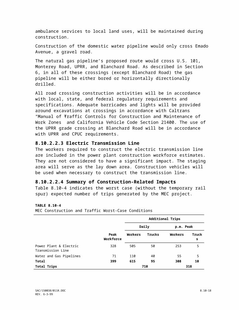
TABLE 8.10-5Estimated 2002 Daily and Peak Hour Construction Traffic Volumes and LOS Worst-Case Conditions for the Proposed and Alternative Access Roads
Daily Volume P.M. Peak Hour Volume & LOS
Proposed Alternative Proposed Alternative
Street Segment No. of Lanes
Background Traffic
Project Traffic
Cumulative Traffic
Project Traffic
Cumulative Traffic
Background Traffic
Project Traffic
Cumulative Traffic
Project Traffic
Cumulative Traffic
Santa Teresa BoulevardBernal Road/Avenida Espana 2
414,38014,380
5050
14,43014,430
710710
15,09015,090
1,4401,440
EA
2525
1,4651,465
EA
318318
1,7581,758
EB
Avenida Espana/South of Bailey Ave.
2 9,220 0 9,220 710 9,930 860 D 0 860 D 318 1,178 E
Monterey RoadBernal Road/South of Bailey Ave. 4 27,750 710 28,460 50 27,800 3,545 C 318 3,863 D 25 3,570 C
Bailey Avenue
Santa Teresa Blvd./Monterey Rd. 2 7,265 25 7,290 95 7,360 675 C 50 725 C 15 740 C
Bernal RoadMonterey Road/Via del Oro 4 25,290 50 25,340 585 25,980 2,365 C 25 2,390 C 210 2,575 C
Via del Oro/Realm Drive 4 30,025 50 30,075 585 30,610 2,800 C 25 2,825 C 210 3,010 D
Realm Drive/Santa Teresa Blvd. 4 27,930 50 27,980 585 28,515 2,605 C 25 2,630 C 210 2,815 C
U.S. 101 North of Bernal Road 5
880,93080,930
195195
81,12581,125
195195
81,12581,125
6,6206,620
CB
6060
6,6806,680
C/BC/B
6060
6,6806,680
CB
Bernal Road/Cochrane Road 4 90,385 195 90,580 195 90,580 7,460 D 60 7,520 D 60 7,520 D
SR 85U.S. 101/Bernal Road 4 29,430 195 29,625 195 29,625 3,100 B 60 3,160 B 60 3,160 B
West of Bernal Road 4 45,720 195 45,915 195 45,915 4,680 C 60 4,740 C 60 4,740 C
SAC/150038/011R.DOC 8.10-18REV. 6-3-99

management personnel. There will be approximately 20 full-time employees working at the plant. Two operators will work 12-hour rotating shifts (8 a.m. to 8 p.m. and 8 p.m. to 8 a.m.), 7 days per week. The standard shift for the maintenance technicians and administrative positions will be 8 hours per day (8 a.m. to 5 p.m.), 5 days per week, with unscheduled days and hours as required (weekends). Thus, only 10 personnel would commute during the p.m. peak on any workday.During plant operations, trucks will periodically deliver/pickup replacement parts, lubricants, water treatment chemicals, aqueous ammonia, sulfuric acid, trash, and other consumables. Table 8.10-6 highlights expected truck deliveries for the project. On average, there will be two truck deliveries to the project site per day.
TABLE 8.10-6Estimated Truck Traffic at the Facility during Operation
Delivery Type Number and Occurrence of Trucks
Aqueous Ammonia 2 per week (8,000-gallon truck)Sulfuric Acid 1 per month (8,000-gallon truck)Cleaning Chemicals 1 per monthTrash Pickup 1 per weekSanitary Waste 1 per month
Aqueous ammonia is considered a potential inhalation hazard. Sulfuric acid and various cleaning chemicals are considered hazardous materials. According to Division 13 Section 31303 of the California Vehicle Code, the transportation of hazardous materials will be on the state or interstate highways that offer the shortest overall transit time possible. Division 14.3 Section 32105 of the Vehicle Code specifies that unless there is not an alternative route, every driver of a vehicle transporting inhalation hazards shall avoid, by prearrangement of routes, driving into or through heavily populated areas, congested thoroughfares, or places where crowds are assembled.Transporters of inhalation hazardous or explosive materials must contact the CHP and apply for a Hazardous Material Transportation License. Upon receiving this license, the shipper will obtain a handbook, which will specify the routes approved to ship inhalation hazardous or explosive materials. Operating convenience is not a consideration. The exact route of the inhalation or explosive material shipment will not be determined until the shipper contacts the CHP and applies for a license.Table 8.10-7 describes current and future p.m. peak hour volumes and LOS during the operation phase of the MEC project, including traffic from the project site (assuming 26 trips from commuting employees, and 1 delivery truck during the peak hour).Transportation effects associated with power plant operations will not be significant for the following reasons: Visits by trade persons, vendors, consultants, and other non-plant personnel
SAC/150038/011R.DOC 8.10-19REV. 6-4-99

are expected to be minimal and would likely occur primarily during non-peak commute periods.
Deliveries of hazardous materials will be limited. Delivery of these materials will occur over prearranged routes and will be in compliance with all laws, ordinances, regulations and standards (LORS) governing the safe transportation of hazardous materials.
8.10.2.3.2 Electric Transmission Line, Water Supply Pipelines, and Natural Gas PipelineThe only traffic associated with the operation of these lines would be occasional preventative maintenance vehicles or repair vehicles in case of damage to any of the lines. These activities would not result in a significant impact on the local transportation system.
TABLE 8.10.7Estimated 2002 Peak Hour Traffic Volumes and LOS during Operation for the Proposed and Alternative Access Roads
Proposed Alternative
Street SegmentNo. of Lanes
Background Traffic LOS
Project Traffic
Background Traffic LOS
Project Traffic
Background Traffic LOS
Santa Teresa Boulevard
Bernal Road/Avenida Espana 24
1,4401,440
EA
00
1,4401,440
EA
1111
1,4511,451
EA
Avenida Espana/South of Bailey Ave.
2 860 D 0 860 D 11 871 D
Monterey Road
Bernal Road/South of Bailey Avenue
4 3,545 C 11 3,556 C 1 3,546 C
Bailey Avenue
Santa Teresa Blvd./Monterey Road
2 675 C 0 675 C 0 678 C
Bernal Road
Monterey Road/Via del Oro 4 2,365 C 2 2,367 C 10 2,375 C
Via del Oro/Realm Drive 4 2,800 C 2 2,802 C 10 2,810 C
Realm Drive/Santa Teresa Blvd. 4 2,605 C 2 2,607 C 10 2,615 C
U.S. 101
North of Bernal Road 58
6,6206,620
CB
33
6,6236,623
CB
33
6,6236,623
CB
Bernal Road/Cochrane Road 4 7,460 D 3 7,463 D 3 7,463 D
SR 85
U.S. 101/Bernal Road 4 3,100 B 3 3,103 B 3 3,103 B
West of Bernal Road 4 4,680 C 3 4,683 C 3 4,683 C
8.10.3 Cumulative ImpactsNo definite time frame for the development of North Coyote Valley has been established and the 1985 master plan is currently being updated. Due to the substantial infrastructure improvements that are needed prior to development of
SAC/150038/011R.DOC 8.10-20REV. 6-4-99

the area as described in the Master Plan, it is likely that MEC would be in operation before much of the area is developed. The small amount of operational traffic related to MEC will easily be accommodated by the capacity provided by these proposed infrastructure improvements.
SAC/150038/011R.DOC 8.10-21REV. 6-4-99

8.10.4 Mitigation Measures8.10.4.1 Construction PhaseThe railroad crossing for the access road to the MEC site is a private crossing of a roadway not maintained by public authority; although, advance warning signs and other railroad markings will be installed to ensure safe crossing at all times. The crossing will be built to San Jose design standards, including two, 12-foot travel lanes with shoulders. Passive warning signs (advance warning sign, crossbuck, stop sign or yield sign) and/or arm gates will be installed as deemed appropriate by UPRR and San Jose. The construction contractor will coordinate with the UPRR to schedule all heavy equipment and material deliveries crossing times to avoid construction delays, traffic movements, and crossing safety. A railroad crossing with arm gates and flashing signal will be installed. However, if construction starts before the arm gates are operational, flagmen will be used to ensure a safe crossing. The scheduling of heavy equipment and material deliveries, installation of railroad crossing arm gates with a flashing signal, and/or the use of flagmen where necessary will be effective because they ensure that a construction vehicle will not be on the railroad track when a train arrives. Although the effectiveness of these measures cannot be absolutely verified until construction is completed, the onsite construction manager or supervisior will continually monitor the measures to ensure there effectiveness.The construction contractor will prepare a construction traffic control plan and implementation program that addresses timing of heavy equipment and building material deliveries, signing, lighting, traffic control device placement, and establishing work hours outside of peak traffic periods.Methods for mitigating potential traffic impacts caused by construction may include such activities as stationing flag persons at the access road into the site, and placing advance warning flashes, flag persons, and signage along the roadways associated with the natural gas and water pipelines. Damage to any roadways opened during the construction of the natural gas or water pipelines will be repaired to or near their preexisting condition. The construction contractor will work with the local agencies’ engineer to prepare a schedule and mitigation plan for the roadways along the construction routes.It should be noted that most trip reduction strategies are not feasible for the construction phase of the project, primarily because of the differing schedules of trades persons, and the need to transport tools and materials to the job site. However some staggering of the workforce might be possible.
8.10.4.2 Operation Phase8.10.4.2.1 Truck TrafficThe following actions would avoid nuisance problems associated with truck traffic: Shippers of hazardous materials, including inhalation hazards, will adhere to
all applicable LORS for the transport of hazardous materials.
SAC/150038/011R.DOC 8.10-22REV. 6-4-99

Shipment of hazardous materials will occur during business hours, but to the extent possible, during off-peak traffic periods. Depending on the hazardous materials, police and fire departments will be notified prior to transport of shipment.
Shippers will maintain mufflers, brakes, and secure all loose items on trucks to minimize noise and ensure safe operation.
8.10.4.2.2 Employee/Other TrafficSince the total number of trips generated by employees during peak hours is not significant, mitigation is not necessary.
8.10.5 Laws, Ordinances, Regulations and StandardsLaws, ordinances, regulations and standards related to traffic and transportation are summarized in Table 8.10-8 and described in the following subsections. Table 8.10-8 also lists the appropriate agency contract for each of the LORS. Table 8.10-9 presents the permit schedule.
8.10.5.1 FederalThe federal law that applies to the MEC project is the Hazardous Materials Transportation Act of 1974, 49 Code of Federal Regulations (CFR) 397.9, which directs the U.S. Department of Transportation to establish criteria and regulations for the safe transportation of hazardous materials.
8.10.5.2 StateState Laws that would apply to this project include the following (State of California 1999): California Vehicle Code Section 35780 requires the approval for a permit to
transport oversized or excessive loads over state highways. The project will conform to Vehicle Code Section 35780 by requiring that shippers obtain a Single Trip Transportation Permit for oversized loads, as required by Caltrans, for each vehicle.
California Vehicle Code Section 31303 requires that the transportation of hazardous materials be on a state or interstate highways that offer the shortest overall transit time possible. The project will conform to Vehicle Code Section 31303 by requiring that shippers of hazardous materials use the shortest route possible to and from the project site.
California Vehicle Code Section 32105 requires that shippers of inhalation or explosive materials must contact the CHP and apply for a Hazardous Material Transportation License. Upon receiving this license, the shipper will obtain a handbook that will specify the routes approved to ship inhalation hazards. The project will conform to California Vehicle Code Section 32105 by requiring shippers of inhalation or explosive materials to contact the CHP and obtain a Hazardous Materials Transportation License.
California State Planning Law, Government Code Section 65302, requires each city and county to adopt a General Plan, consisting of seven mandatory
SAC/150038/011R.DOC 8.10-23REV. 6-4-99

elements, to guide its physical development. Section 65302 (b) requires that a circulation element be one of the mandatory elements. The scope of a circulation element consists of the “general location
SAC/150038/011R.DOC 8.10-24REV. 6-4-99

TABLE 8.10-8Laws, Ordinances, Regulations, and Standards
LORS Document and Page ApplicabilitySection where
discussed Agency/Contact
FederalRegulations for the safe transport of hazardous materials
49 CFR 397.9 Requires states to regulate transport of oversized or excessive loads over State highways.
8.10.4.1 Under states jurisdiction
StateTransport oversized or excessive loads over State highways
California Vehicle Code Section 35780
Requires approval for a permit to transport oversized or excessive loads over State highways. Enforced by the California Highway Patrol.
8.10.2.28.10.5.2
Caltrans Harold Burnett (Single Trip)(916) 322-1297Dee Garcia (Annual)(916)322-1297
Transport hazardous materials on Interstate highways
California Vehicle Code Section 31303
Requires that the transportation of hazardous materials be on state or interstate highways that offer the shortest overall transit time possible.
8.10.2.28.10.2.38.10.4.2
California Highway PatrolMeg Plenka(916) 445-1865
Shipping of inhalation or explosive materials
California Vehicle Code Section 32105
Requires that shippers of inhalation or explosive materials contact the California Highway Patrol and apply for a Hazardous Material Transpor-tation License. Upon receiving this license, the shipper will obtain a hand-book, which will specify the routes approved to ship inhalation hazards.
8.10.2.28.10.2.38.10.5.2
California Highway PatrolMeg Plenka(916) 445-1865
Requirement to have a General Plan
California Government Code Section 65302
Project must conform to the General Plan 8.10.5.3
LocalMitigation Plan Coordinates with the local agencies to develop a mitigation plan and
schedule to repair the roadways along the construction routes8.10.4.1 San Jose, Public Works
(408) 277-5161
San Jose General Plan (1994) Provides for the long-range planning and development of the City’s roadway system and the efficient movement of people and goods throughout the city.
8.10.5.3
California Vehicle Code Sec-tions 35780, 35781, and 35795
Transportation permit for oversized vehicles 8.10.5.3 San Jose, Street and TrafficTransportation Permit(408)277-4304
California Streets and Highway Code, Division 2 Chapter 5.5 Sections 1460-1470
Encroachment permit 8.10.5.3 San Jose, Public Works(408)277-5161
Santa Clara General Plan (1995)
Set standards for local and regional Transportation System Management, Travel Demand Management, and Transportation facilities
8.10.1.3
Santa Clara Valley Transportation Authority
Congestion management program for County and cities within. Establishes standards and programs for regional transportation facilities
8.10.1.3
Union Pacific Railroad Encroachment permit Pipeline, Wireline and Drainage DepartmentJon Devish(402) 997-3563
Union Pacific Railroad Railroad crossing installation , Private and Public Railroad Crossing Manager of Industry and Public ProjectsJim Smith(412) 541-1421
California Public Utilities Railroad crossing installation , Public Railroad Crossing, work with UPRR Hagi Jahed
SAC/150038/011R.DOC 8.10-25REV. 6-4-99

TABLE 8.10-8Laws, Ordinances, Regulations, and Standards
LORS Document and Page ApplicabilitySection where
discussed Agency/Contact
Commission CPUC(415) 703-2701
SAC/150038/011R.DOC 8.10-26REV. 6-4-99

TABLE 8.10-9Permit Schedule for Traffic and Transportation
Permit Schedule
Transport oversized or excessive loads over state highways from State Agency
Obtain when necessary, 2 hour processing time (single trip) to 2 weeks (annual trip).
Transportation permit for oversized vehicles from State Agency
Obtain when necessary, same day processing.
Transportation permit for oversized vehicles or excessive loads from San Jose
Obtain when necessary, same day approval by Street and Traffic Department.
Franchise Agreement for natural gas pipeline from San Jose
6 weeks to 6 months
Encroachment permit for water supply and discharge pipelines, wireline from Union Pacific Railroad
6 weeks to 6 months by Pipeline, Wireline and Drainage Department.
Private railroad crossing installation from Union Pacific Railroad
30 to 180 days by Manager of Industry and Public Projects.
and extent of existing and proposed major thoroughfares, transportation routes, terminals, and other local public utilities and facilities, all correlated with the land use element of the plan.” Compliance with this section is described below under the local LORS.
8.10.5.3 LocalThe transportation and circulation element of the San Jose General Plan (1994) sets forth policies that are applicable to the MEC project. They are as follows: The City’s level of service standards for the state highway system and
specific routes of regional significance shall be those standards adopted in the Santa Clara Congestion Management Program.
The City shall require all new development projects to analyze their contribution to increased traffic and to implement improvements necessary to address the increase.
The California Streets and Highways Code Division 2 Chapter 5.5 Sections 1460-1470 mandates that an encroachment permit be obtained from the City Public Works Department if there is an opening or excavation for any purpose in any highway.
In compliance with the San Jose Circulation Element, the contribution to increased traffic has been analyzed and during the construction period MEC would only cause a temporary reduction in LOS at one intersection from LOS D to LOS E. No degradation in the LOS would result from MEC’s operation. In addition, encroachment permits will be acquired as appropriate.Similarly, Santa Clara County’s General Plan sets standards for local and regional transportation system management, travel demand management, and transportation facilities. The Santa Clara Valley Transportation Authority establishes regional standards and programs for transportation including the Congestion Management Program. As discussed in Section 8.10.1.3, the project
SAC/150038/011R.DOC 8.10-27REV. 6-4-99

will comply with the requirements of the County’s Congestion Management Plan, which is overseen by the Santa Clara Valley Transportation Authority. Only two roadway segments in the project vicinity experience a daily LOS D. All other segments are experiencing a LOS of C or better, meeting or exceeding the CMP minimum standard of LOS E.
8.10.6 ReferencesCalifornia Department of Transportation (Caltrans). 1998. 1997 Accident Summary on California State Highways.Caltrans 1999. 1997 Annual Average Daily Truck, Traffic on the California State Highway System.Caltrans. 1999. 1997 Traffic Volumes and County of Santa Clara 1994 to 1998 Traffic Counts.Caltrans. 1999. Internet site: www.dot.ca.govSan Jose Department of City Planning and Building. 1985. Master Development Plan and Guidelines for the North Coyote Valley Industrial Area.San Jose Department of City Planning and Building. 1994. San Jose 2020 General Plan. County of Santa Clara. 1994 Santa Clara County General Plan. Charting a course for Santa Clara County’s Future: 1995-2010.Eychner, Mr. 1999. Personal Communication, Eychner, San Jose Street and Traffic Department Little, Mr. 1999. Personal Communication, Little, California Highway Patrol, February 1999.Martarano, Charles. 1999. Personal Communication, San Jose Streets and Transportation Department, Transportation Engineer, February 1999. Santa Clara Valley Transportation Authority, 1997. Traffic Level of Service Analysis Guidelines.Santa Clara Valley Transportation Authority, 1998. Transportation Impact Analysis Guidelines.Union Pacific Railroad. 1999. Internet site: www.uprr.com
SAC/150038/011R.DOC 8.10-28REV. 6-4-99