Embed Size (px)
Citation preview
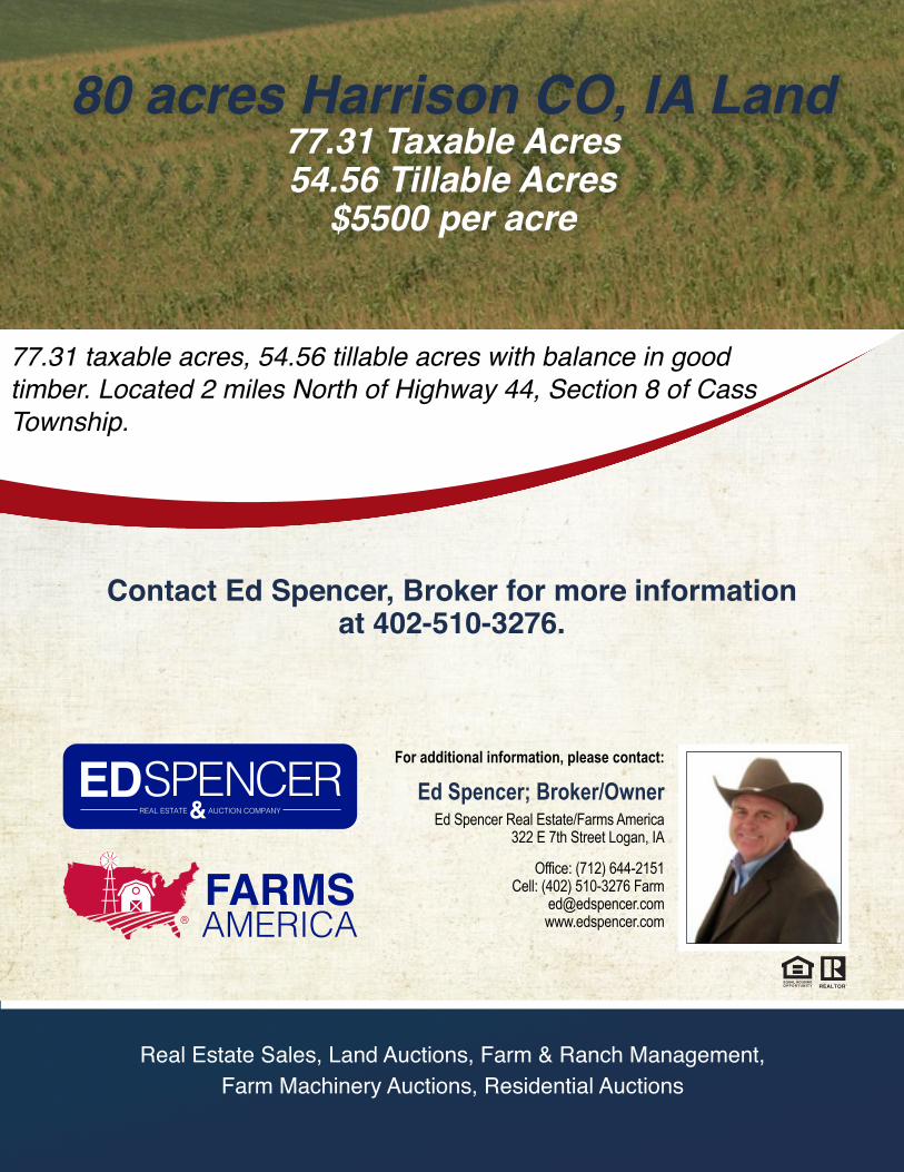
77.31 taxable acres, 54.56 tillable acres with balance in good timber. Located 2 miles North of Highway 44, Section 8 of Cass Township.
80 acres Harrison CO, IA Land77.31 Taxable Acres54.56 Tillable Acres
$5500 per acre
Real Estate Sales, Land Auctions, Farm & Ranch Management, Farm Machinery Auctions, Residential Auctions
Contact Ed Spencer, Broker for more informationat 402-510-3276.
For additional information, please contact:
Ed Spencer; Broker/OwnerEd Spencer Real Estate/Farms America
322 E 7th Street Logan, IA
Office: (712) 644-2151Cell: (402) 510-3276 Farm
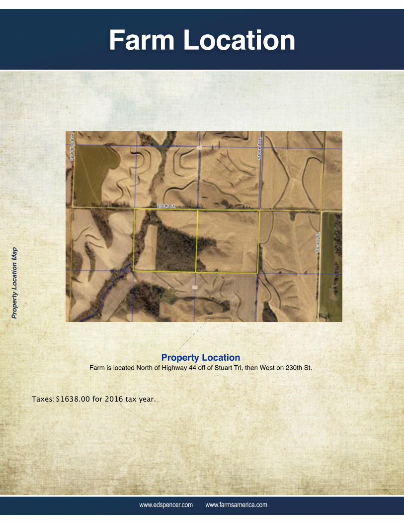
Farm Location
www.edspencer.com www.farmsamerica.com
Prop
erty
Loc
atio
n M
ap
Property LocationFarm is located North of Highway 44 off of Stuart Trl, then West on 230th St.
Taxes: $1638.00 for 2016 tax year.

CSR MAP
www.edspencer.com www.farmsamerica.com
156 EZ
www.edspencer.com www.farmsamerica.com
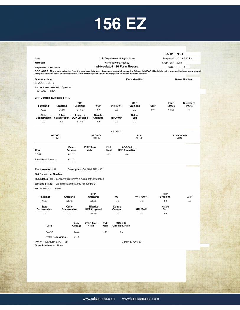
U.S. Department of AgricultureFarm Service Agency
Abbreviated 156 Farm Record
FARM:Prepared:
Page:Report ID: FSA-156EZ
Crop Year:
7000
20188/3/18 2:50 PM
1 of 1
IowaHarrison
DISCLAIMER: This is data extracted from the web farm database. Because of potential messaging failures in MIDAS, this data is not guaranteed to be an accurate andcomplete representation of data contained in the MIDAS system, which is the system of record for Farm Records.
Farmland CroplandDCP
Cropland WBP WRP/EWP
StateConservation
GRP
OtherConservation
EffectiveDCP Cropland
DoubleCropped
NativeSod
Operator Name Farm Identifier
FarmStatus
Recon Number
CRPCropland
MPL/FWP
78.09 54.56 0.0 0.0 0.0
0.0 0.0 0.0
54.56
0.0
0.0
0.0
Active
54.56
SHADON J BLUM
Farms Associated with Operator:2740, 6017, 6804
CRP Contract Number(s): 11427
Number ofTracts
1
ARC/PLCPLC-DefaultPLCARC-COARC-IC
CORNNONE NONE NONE
PLCYield
CTAP TranYield
BaseAcreageCrop
CCC-505CRP Reduction
134CORN 50.02 0.0
50.02Total Base Acres:
Farmland CroplandDCP
Cropland WBP WRP/EWP GRP
StateConservation
OtherConservation
EffectiveDCP Cropland
DoubleCropped
NativeSod
CRPCropland
MPL/FWP
Tract Number: 418 Description: Q8 N1/2 SEC 8 D
78.09 54.56 54.56 0.0 0.0 0.0
0.0 0.0 0.0 0.0
0.0
0.0
BIA Range Unit Number:
CropBase
AcreageCTAP Tran
YieldPLCYield
CCC-505CRP Reduction
CORN 13450.02 0.0
Total Base Acres: 50.02
54.56
Wetland Status:
HEL: conservation system is being actively applied
Wetland determinations not complete
WL Violations: None
DEANNA L PORTER JIMMY L PORTEROwners:
HEL Status:
NoneOther Producers:

FSA MAP
www.edspencer.com www.farmsamerica.com
230THST
STO
NE
AVE
CASS8
CASS5
1
2.41
HEL
3
44.83
HEL
2
7.32
HEL
T 418
4 23.53
United StatesDepartment ofAgriculture
Farm 7000
²2018 Program Year
Harrison County, Iowa
Map Created May 31, 2018
Tract 418
0 340 680170
Feet
United States Department of Agriculture (USDA) Farm Service Agency (FSA) maps are for FSA Program administration only. This map does not represent a legal survey or reflect actual
ownership; rather it depicts the information provided directly from the producer and/or National Agricultural Imagery Program (NAIP) imagery. The producer accepts the data 'as is' and
assumes all risks associated with its use. USDA-FSA assumes no responsibility for actual or consequential damage incurred as a result of any user's reliance on this data outside FSA
Programs. Wetland identifiers do not represent the size, shape, or specific determination of the area. Refer to your original determination (CPA-026 and attached maps) for exact
boundaries and determinations or contact USDA Natural Resources Conservation Service (NRCS).
Wetland Determination Identifiers
&- Restricted Use
#*
Limited Restrictions
")Exempt from Conservation
Compliance Provisions
Tract Cropland Total: 54.56 acres
USDA is an equal opportunity provider, employer, and lender.
LegendNon-Cropland
Cropland
CRP
Tract Boundary
Iowa PLSS
Iowa Roads
NAIP\USDA_CONUS_PRIMERGB
Red: Band_1
Green: Band_2
Blue: Band_3