Embed Size (px)
Citation preview

85 Customs Street
Apartment Tower
Section 88
Resource Consent Application
and
Assessment of Environmental Effects
April 2016
TABLE OF CONTENTS
1.0 INTRODUCTION ..................................................................................................................... 1
1.1 Summary of Applicant and Property Details .......................................................................... 2
2.0 PROPOSAL ............................................................................................................................. 4
3.0 Site Locality & Description ................................................................................................... 11
4.0 CONSENT REQUIREMENTS ................................................................................................... 14
4.1 Auckland District Plan (Central Area Section) 2005 ............................................................. 14
4.2 Other consent requirements ............................................................................................... 14
4.3 Compliance Summary .......................................................................................................... 15
5.0 ENVIRONMENTAL EFFECTS ASSESSMENT .............................................................................. 27
5.1 Character & Amenity............................................................................................................ 27
5.2 Design ................................................................................................................................... 30
5.3 Visual, dominance, shading, streetscape ............................................................................. 33
5.4 Traffic ................................................................................................................................... 35
5.5 Ground contamination ......................................................................................................... 36
5.6 Geotechnical ........................................................................................................................ 37
5.7 Groundwater and settlement and settlement effects ......................................................... 37
5.8 Acoustic ................................................................................................................................ 38
5.9 Infrastructure ....................................................................................................................... 39
5.10 Heritage ................................................................................................................................ 39
5.11 Summary .............................................................................................................................. 40
6.0 STATUTORY ASSESSMENT .................................................................................................... 41
6.1 RMA ...................................................................................................................................... 41
6.1.1 Actual and Potential Effects .................................................................................... 41
6.1.2 The relevant provisions of any plan or proposed plan ........................................... 42
7.0 OTHER MATTERS ................................................................................................................. 57
8.0 NOTIFICATION ..................................................................................................................... 57
9.0 SECTION 104D NON COMPLYING ACTIVITIES ........................................................................ 59
10.0 Part 2 RMA .......................................................................................................................... 59
11.0 CONCLUSION ....................................................................................................................... 61
Supporting Documents Provided
1. Certificates of Title
2. Architectural Plans
3. Design Analysis
4. Design Statement
5. Urban Design and Visual Assessment & Photosimulations
6. Transportation Assessment
7. Heritage Assessment & HNZ Written Approval
8. Acoustic Report

9. Contamination Report and Site Management Plan
10. Wet Services (Infrastructure) Report
11. Geotechnical Report
12. Groundwater Report and Monitoring & Contingency Plan
13. Flood Risk Assessment
14. Wind Report
15. Surveyor Statement
1
1.0 INTRODUCTION
This report is submitted in support of the land use resource consent application to the Auckland Council
by Shundi Customs Limited (the Applicant) to utilise the land at 69-150 Customs Street East, Auckland
CBD for a proposed 50 level mixed use development incorporating ground floor commercial units (retail
food and beverage, lobby and through site lanes), a variety of residential unit types on the upper floors
and associated parking (both above ground and in the basement). The applicant (and/or its
representatives) has met with or discussed the proposal with Council officers and the Auckland Urban
Design Panel in developing up the proposal. The objective being to outline the proposal and understand
the issues that may exist with it and the information requirements needed for the application.
The proposal requires district land use consents as required by the Central Area Plan and set out in this
report as well as several regional plan consents and consents under the Proposed Auckland Unitary Plan.
The proposed development will be a significant addition to the Auckland City Centre skyline and therefore
great care has been taken in the design of the development in order to ensure a development of high
quality results and one that is fitting for its location within the City Centre.
In support of this application, the following technical/expert information/assessments are provided:
1. Certificates of Title
2. Architectural Plans
3. Design Analysis
4. Design Statement
5. Urban Design and Visual Assessment and Photosimulations
6. Transportation Assessment
7. Heritage Assessment
8. Acoustic Report
9. Contamination Report and Site Management Plan
10. Wet Services (Infrastructure) Report
11. Geotechnical Report
12. Groundwater Report and Monitoring & Contingency Plan
13. Flood Risk Assessment
14. Wind Report
15. Surveyor Statement

2
The report addresses the relevant matters required under section 88 of the Resource Management Act
1991 (RMA) and in terms of an Assessment of Environmental Effects (AEE) pursuant to the Fourth
Schedule of the RMA. The report provides the information necessary for a full understanding of the
proposed activity, for which resource consent is sought, and any actual or potential effects the proposal
may have on the environment.
1.1 Summary of Applicant and Property Details
Site Details
Address: 69 Customs Street, Auckland Central 1010
71-77 Customs Street, Auckland Central 1010
87 Customs Street, Auckland Central 1010
95-105 Customs Street, Auckland Central 1010
CT: NA47C/455, Lot 1, DP 43134, 784m2
80661, Lot 1, DP 320362, 1123m2
NA100C/316, Lot 1, DP 51212, 544m2
NA761/82, Lot 35 Sec 2 City of Auckland, 278m2
Site Area: 2,729m2
Operative District Plan Controls:
Strategic Management Area 1 (SMA 1)
Pedestrian Orientated Area
Queen Street Valley Precinct
Additional Limitations:
Sunlight Admission Control: Emily Place & Old Government House.
Road Classification:
Customs Street East – District Arterial
Gore Street – Collector Road
Gore Street Lane – Local Road

3
Road Type: Customs Street East – Type 2 Road – Parking Ratio = Maximum of 1 carpark
per 200m2 GFA
Gore Street: Type 3 Road – Parking Ratio = Maximum of 1 carpark per 150m2 GFA
Gore Street Lane – Type 3 Road – Parking Ratio = Maximum of 1 carpark
per 150m2 GFA
Proposed Auckland Unitary Plan Controls:
City Centre Zone
Queen Street Valley Precinct
Vehicle Access Restriction General
Rose & Crown – Scheduled Building & Pre-1944 Demolition Control Overlay
City Centre Port Noise 56 dB
Coastal Inundation – 2m sea level rise
Core Retail Area
75% Glazing Control
70% Ground Floor Activity Control
Verandah Control
Additional Limitations:
Sunlight Admission Control: Emily Place & Old Government House.
Infrastructure: There are existing stormwater, wastewater and water lines running along
Customs Street East and Gore Street Lane, none of which go across the site.
Existing Land Use: Commercial Car Parking, Office Buildings, Retail, Food & Beverage and
Tavern

4
2.0 PROPOSAL
The proposal has been consistently referred to the documentation accompanying the application as
follows:
Project Name: Customs Residential
Client: Shundi Customs Ltd
Address: 69-105 Customs Street East, Auckland
Project Description (Rev C) 03/11/2015
The development site is located at 69-105 Customs Street East, bounded by Customs St / Gore Lane and
Fort St and currently comprises of Ballantyne House to the East, The White Rabbit to the West and a
vacant ground level carpark between. The proposed development incorporates a new tower building
comprising of 50 levels above ground (including 2 upper plantroom floors) and 5 basement levels and the
refurbishment of the existing 12 level Ballantyne House. The new tower building is predominantly
residential with some office, retail and hospitality on the lower floors, as well as 2 levels of above ground
parking. The existing office building will be converted into a boutique hotel.
The development comprises two buildings as described below, connected at the lower podium level:
Tower Building
50 levels above ground (incl. GL) and 5 basement levels.
Levels B5 – B2 are carparking with a total of 145 carparks 2 of which are mobility carparks.
Level B1 comprises of 7 carparks 4 of which are mobility carparks, main communications room, fire
control room, security room, transformer room, fire sprinkler valve room and potable water
storage tank.
Ground level with a 7m slab to slab height comprises approx. 620 m² retail space, the apartment
lobby, entry to the VIP carpark lift and truck dock.
An open laneway at ground level accessing the adjacent tenancy spaces and the apartment lobby
area to the rear.
Level 1 with a 5m slab to slab height comprises approx. 630 m² retail and 290m² hospitality space.
It includes a public link to Ballantyne House.

5
Level 2 comprises VIP parking for 20 cars, approx. 140m² retail, 150m² storage and double height
services plantrooms.
Level 3 comprises VIP parking for 20 cars, approx. 150m² storage and the void to the retail and
services plantrooms below.
Levels 5 and 6 each with a gross area of approx. 500m² each for commercial office space. They
include an external podium area each, connected by external stair.
Level 7 accommodates a health spa including swimming pool, spa pool, gym, sauna and changing
facilities.
Levels 8-40 provide high quality residential accommodation with 6 - 8 apartments per floor.
Levels 41-46 accommodate penthouses (2 per level).
Levels 47-50 accommodate single level penthouses (1 per level).
Levels 51-52 accommodate a single 2 level penthouse.
Levels 53-55 comprises roof level plant including building damper, 2 water tanks and pumps.
Ballantyne House
An existing building comprising 1 basement level and 11 above ground floors.
To be fully refurbished back to the existing base structure.
An existing basement of 740m² will provide parking for 17 carparks 1 of which is for mobility.
A ground level lobby and approx. 330m²of retail and hospitality as well as the hotel reception.
An open laneway at ground level between the tower and Ballantyne House accessing the adjacent
tenancy spaces.
Level 1 comprising of approximately 300m² of hospitality space.
Level 2 comprising of 6 hotel accommodation rooms, bar and outdoor garden area.
Levels 1 – 10 hotel accommodation. Each 400m² floor plate will provide 10 hotel rooms.
Rose & Crown
It is proposed to retain the two level White Rabbit Tavern within this building.
The rear non-heritage annex is to be removed and the wall made good with re-instated
openings;
The eastern wall will be refurbished and made good once the adjoining building is removed.

6
Tower Building
Levels Above Ground (incl.
GL)
50 (incl. 2x upper
plantroom floors)
Levels Below Ground 5
Building Height 192m
Basement Depth *1 16.56m
Apartments (excl.
Balconies)
221
Studio Apartments 80 (40m2)
1 Bedroom & Study 60 (63m2)
2 Bedroom Duplex 10 (118m2)
3 Bedroom 56 (96m2)
Penthouse Apartments 15 (varies from 170-
290m2) Carparks 192
B1 – B5 152 incl. 6 accessible
L1 - L2 40
Lifts 4 Passenger (B5-L51)
*2
in
1 Goods (B1-L39)
2 Shuttle (B3-L8)
2 Car (G-L3)
1 Goods Lift (B1-L40)
Ballantyne House
Levels Above Ground (incl.
GL)
12
Levels Below Ground 1
Building Height 46m
Basement Depth *1 2.82m
Suites 96
Typical suites / floor 10 x 9 floors (from L3
and above) Level 1 6
Carparks (B1) 17 incl. 1 accessible
Lifts 2 Passenger (B1-L12)
*3
The White Rabbit
Levels Above Ground (incl.
GL)
2
Levels Below Ground 1 x Part basement

7
Building Height 11.35m
Basement Depth -
Notes:
1. Basement depth is measured to top of lowest slab
2. 1 passenger lift will serve L52 apt. level to access stair to L53 plantroom
3. No lift to roof plantroom
4. Apartment sizes/numbers are subject to amendment depending of detailed design and design
evolution, however the required standards will be met except where modification of the
controls/standards has been requested.
As noted above, the development comprises a primary 50 level mixed use residential apartment tower
with a five level basement carpark as well as a secondary existing building which is to be refurbished into
a hotel and a third two level heritage building which will be retained. The proposal includes all the
elements outlined in this report, the plans and all the technical reports accompanying the application
(outlined above).
The proposed development has been reviewed by the Urban Design Panel and the Panel’s comments are
addressed in the drawing set, the Design Summary and the Design Statement. The Panel also
recommended enclosing the balconies to the residential apartments in order to provide weather
protection. The Panel supported a gross floor area infringement to achieve this if necessary.
In summary, the proposal includes the following:
Buildings/Activities
The development of a new 50 storey mixed use and residential tower with a five level parking basement.
The refurbishment of the 12 storey Ballantyne House with a single level basement into a hotel. The
retention and alteration of the scheduled Rose & Crown building, which will continue to operate as a
tavern. The maximum height of the new tower will be approximately 192m.
The mix of apartments and hotel unit sizes is set out above in the summary table.
In terms of activities, the podium will be occupied by a variety of uses including retail, food and beverage,
lobbies, through site links, services and vehicle operational activities, parking, offices, a pool, terrace and
gymnasium. Upper floor will be occupied by hotel rooms and residential apartments.

8
A unique feature of this building is the orientation of all the units towards the harbour (or with harbour
views). This has been a specific requirement of the applicant. This enables a high quality glazed frontage
to the building and the potential enclosure of the upper level balconies with glazed sliding doors. This
provides al all weather patio area at the upper levels of the building, thereby providing quality private
outdoor amenity space.
Another feature of the north elevation is the location of the courtyard spaces which will accommodate
greenery and will enliven and activate the frontage of the building.
Another defining feature of the building is the steel mega brace which runs up the eastern and western
sides of the building. This is the primary structure of the building, which is mainly constructed from steel.
The rear elevation is mainly opaque glass, steel, services and bracing.
In terms of amendments to the design that have been made to respond to the comments of the Urban
Design Panel, the following changes have been incorporated:
Tower verticality - Duplex (garden) apartment arrangement revised, additional vertical garden
elements implemented – the intent to elongate the verticality of the tower.
Podium connectivity –
garden feature of the tower extended through the podium to ground level – the intent
is to better relate / connect podium and tower
encapsulating element introduced to reference historic sub divisional grain, each bay
through the podium better defined in turn repeated up through established bays of the
tower. In a sense the element is mirrored about the pool or negative element separating
tower and podium.
West podium elevation (behind megabrace) – revised to predominately solid element offering
solidity and depth to the podium component.
Ballantyne House will be refurbished on its exterior with curtain wall glazing and aluminium and extruded
fins as well as opaque glass. In terms of amendments to the design that have been made to respond to
the comments of the Urban Design Panel, the following changes have been incorporated:
Simplification of predominant northeast aspect – essentially the depth of north façade return
increased, east façade framework increased one bay…together allowed a simple flat glazed

9
separating element as opposed to previous version where we had a number of hit and miss
panels at various widths.
South east corner – further development resulted in a more identifiable or separate podium
component. The scale or height has also been increased to better relate to south end of tower
podium.
Ground level interior re-planned to emphasize northeast corner entry to southwest corner
Hotel lobby connection / circulation.
Full details of the building design are set out in the Design Statement and Design Summary.
Construction Materials
The proposed developed will be constructed from a wide variety of quality materials which have been
combined together to produce the high quality design. The elegant design features a strong steel mega
brace, curtain wall glazing, stone/GRC façade, green walls, and opaque glass. Full details of the materials
are set out in the Design Statement and Design Analysis.
Construction
The details of the construction are set out in detail in the Geotechnical Report, Groundwater Report and
Monitoring & Contingency Plan and the Contamination Report and Site Management Plan. It is proposed
to construct the basement either through a temporary secant pile retaining wall or a diaphragm wall.
Both will enable the management of the groundwater table drawdown and associated settlement during
construction with the diaphragm wall enabling less groundwater inflow into the excavation.
It is proposed to initially excavate around the perimeter of the site, followed by the remainder of the
excavation of the internal parts of the site. In total, approximately 25,000m3 of excavated material will
be removed from the site. Temporary silt retention devices will be located on site, with silt fences around
them, in order to ensure that any surface water running over the excavated area will be collected. The
perimeter piling will be completed prior to the internal part of the site is excavated.
A temporary construction access will be created on Customs Street or Gore Street Lane. Bulk excavation
is expected to take sixty weeks to complete with an overall construction timeframe of 205 weeks
envisaged. A wheel wash will be provided in order to ensure silt laden vehicle wheels are cleaned prior
to exiting the site.
10
The proposal also includes the removal of contaminated soil from the site and the diversion of
groundwater as the basement will be excavated below ground water levels of around 3.0m below ground
level. Contaminated soil will be disposed of to an approved landfill.
Infrastructure
Provision of stormwater infrastructure connections, wastewater connections and other services (water,
power and telecommunications) will all form part of the development. These are assessed in detail in the
Wet Services Report and it is confirmed that there is sufficient capacity in the various networks to
accommodate the proposed development.
This includes three stormwater pipes in the vicinity that can service of the development varying in
diameter between 300mm to 750mm, three wastewater pipes in the vicinity varying in capacity
between225mm to 300mm and three water supply pipes varying in capacity from 150mm to 200mm. The
report confirms that there is sufficient pressure for fire service requirements.
Other infrastructure such as power and telecommunications will be readily satisfied by the existing
network.
Traffic
The traffic matters relating to the proposal have been assessed in detail in the Transportation Assessment
provided. The proposal includes combined vehicle access points off Gore Street Lane. This includes access
to the basement carparks, car lift access to the upper level carparks and loading dock access. Overall 209
carparks are provided, 169 in the basement and 40 above ground. The above ground carparks are
proposed to be used for VIP’s and will have lift access direct to Gore Street Lane. A hotel drop off point is
also proposed on Gore Street Lane.
Public transport opportunities are located nearby, including the Britomart Train Station, ferries and buses.
A construction traffic management plan is recommended to deal with the management of construction
traffic issues.
Overall
The proposed development has been intricately developed, critiqued and designed in order to produce a
quality residential living environment as well as containing commercial and recreational activities in the
podium. Detailed consideration has gone into the design, materials, traffic and infrastructure elements

11
of the proposal. A conscious effort has been made to provide a variety of unit types and for them to have
outlook over the harbour – with quality enclosed balconies/terraces.
3.0 Site Locality & Description
The site and locality description is outlined in the Design Statement and Design Analysis submitted with
the application and in many of the technical reports supporting the proposal. These documents should
be referred to for a full understanding of these matters.
The site is located on the eastern side of the Auckland’s CBD, between Customs Street East, Fort Street,
Gore Street Lane and Gore Street. An aerial photo of the site is included below. The site is part of the
pedestrian-orientated activities area and part of the Queen Street Valley Precinct, and is also identified to
be within Strategic Management Area 1 (SMA1) within the District Plan. The purpose of the pedestrian-
orientated area is to encourage a range of activities, while the Queen Street Valley Precinct provides a
development strategy with more specific activity controls that provides for development compatible with
the characteristics of the specific area. Strategic Management Area 1 aims to provide a quality
environment, an accessible centre, especially for alternative modes of transport to private vehicle use,
vibrant public places distinctive to the SMA and improving opportunities for a diverse range of commercial
uses. Consequently, the planning controls applicable to the area aim to achieve a high level of
development while preserving and enhancing the amenity value of the Central Area.
There are numerous high rise towers to the south of the site and the development site itself is located on
an important road frontage within the Central Area. To the north is the Britomart Precinct and the
waterfront beyond. The site plays an important role in connecting the City Centre with the Britomart
Precinct and the waterfront. The subject site faces the Britomart Precinct in Strategic Management Area
2 to the north and is in proximity to a Residential Precinct in Strategic Management Area 5 to the east.

12
Diagram 1: Aerial Photograph

13
Diagram 2: Central Area District Plan Zone
Further details and images of the site and locality (with and without the proposed building) are included
in the Photosimulations and Urban Design/Visual Assessment submitted with the application.

14
4.0 CONSENT REQUIREMENTS
4.1 Auckland District Plan (Central Area Section) 2005
The site is located within the Queen Street Valley Precinct and within Strategic Management Area 1
and the Pedestrian Orientated Area. The following resource consents are required:
Demolition of an existing building is a restricted controlled activity under rule 5.5.1
Non-permanent accommodation is a restricted discretionary activity under rule 5.5.1
Provision of more than 100 carparks is a restricted controlled activity under rule 9.6
Provision of carparking that does not meet the size and dimensional requirements is a restricted
discretionary activity under rule 9.7.2
Modification of access provisions is a restricted discretionary activity 9.7.3
Alterations and additions to a scheduled item is a restricted discretionary activity under rule
10.9.11.
The erection of a new building within the Queen Street Valley Precinct is a restricted discretionary
activity under rule 14.4.6.1
Modification of the frontage height and setback rule is a restricted discretionary activity under
rule 14.4.8 & 15.3.1.2(b)
Modification of the Maximum Total Floor Area control is a non-complying activity under rule 6.7.3
and 14.4.4.8.1.
Redevelopment of a contaminated or potentially contaminated site is a restricted discretionary
activity under rule 11.7.7.5. Also, under the NES for contamination a restricted discretionary
activity resource consent is required under regulation 10(1) for soil disturbance.
It is possible that some of the piling activity will infringe the construction noise rule 7.6.4 and
therefore a non-complying activity resource consent is required.
Overall, the proposal is to be assessed as a non-complying activity under the Operative District Plan.
4.2 Other consent requirements
Proposed Auckland Unitary Plan: Clause 4.2.1 states that earthworks greater than 2500m2 and
2500m3 in a business zone (includes City Centre) will be considered as a restricted discretionary
activity.

15
Proposed Auckland Unitary Plan: Under rule H.4.4.5.2.2.2 disturbance or remediation of
contaminated land requires a controlled activity resource consent
Proposed Auckland Unitary Plan: Under rule H.4.4.17.1 the diversion of groundwater requires are
restricted discretionary activity resource consent.
Proposed Auckland Unitary Plan: Under rule J.2.2.1 the partial demolition of a historic heritage
item is a discretionary activity
Auckland Regional Plan: Air Land, Water: Under rule 5.5.43/44/44A/45 of the Air, Land, Water
Plan it is likely that the proposed development requires either a controlled, restricted
discretionary or discretionary activity resource consent for contamination matters. As a result,
this consent is applied for.
4.3 Compliance Summary
The relevant planning provisions that apply to this proposal are outlined in summary below. I note that
not all the rules are referred to below:
Activity Rules
The relevant controls that apply to activities with the Queen Street Valley Precinct that can be undertaken
on the subject site are identified in Section 14.4.6 of the District Plan and refer back to Part 5 of the
Operative District Plan. They are as follows.
Land use activity Activity Status
The external alteration or addition to the street frontage
of any existing building, excluding minor cosmetic
alterations or repairs which do not change the design and
appearance of the existing building and construction of a
new building.
Restricted Discretionary
Accommodation Permitted
Non-permanent accommodation Restricted Discretionary
Ancillary Parking within the allowable parking maximum
ratios
Permitted
Food and beverage Permitted
Entertainment/gathering Permitted
16
Industry Permitted (where the activity is
located not less than 6m above
MSL or is below MSL
Offices Permitted
Retail Permitted
Demolition of buildings (except as noted below) Restricted controlled
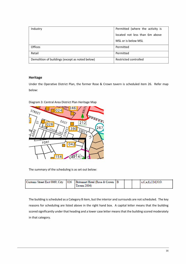
Heritage
Under the Operative District Plan, the former Rose & Crown tavern is scheduled item 26. Refer map
below:
Diagram 3: Central Area District Plan Heritage Map
The summary of the scheduling is as set out below:
The building is scheduled as a Category B item, but the interior and surrounds are not scheduled. The key
reasons for scheduling are listed above in the right hand box. A capital letter means that the building
scored significantly under that heading and a lower case letter means that the building scored moderately
in that category.

17
The partial demolition of a category B item requires a restricted discretionary activity resource consent
application under rule 10.9.11.c. The removal of the rear of this building and works to the eastern wall
will require consent, and has been assessed in the heritage report.
Development Controls
The following development controls apply to the Queen Street Valley Precinct that is applicable to the
subject site. Rule 14.4.8 sets out the relevant controls and links back to Part 6 of the Operative District
Plan.

18
Development
Control
Queen Street Valley Precinct
Maximum Height
(Rules 6.2 & 6.3)
The only height control applicable to the subject site is the
Admission of Sunlight to Emily Place control, requiring that
the public open space at Emily Place during 12 noon – 2.00pm
(April 1 to September 30) and 11.00am – 2.00pm (October 1
to March 31). Under this control, the maximum building
height achievable is between 100m-230m diagonally across
the site from the north-eastern corner of the site to the
south-western corner of the site. Refer diagram below
showing height contours. Compliance has been confirmed by
survey.
Also, the south-western corner of the site is also controlled
by the Old Government House Gardens special height control.
Compliance with this control has need been confirmed.
The admission of sunlight plane appears to allow for a
maximum building height of 80m -230m diagonally across the
site from the north-eastern corner to the south-western
corner taken from MSL. Approximately, 150m at the centre
of the block taken from MSL.

19
The proposal complies with this control.
Site Intensity (Rules
6.7 & 14.4.8.2 (iv) –
(vii).
Basic floor area ratio – 6:1
Maximum total floor area ratio – 10:1 (refer Queen Street
Valley specific provision below)
Bonus Area 1
It is noted that rule 6.7.3.a.i indicates that no Average Floor
Area calculation is required to achieve the maximum total
floor area on the application site as the site is specifically
identified on Precinct plan C of the Queen Street Valley
Precinct. Specific site intensity controls for the Queen Street
Valley Precinct are set out in rule 14.4.8.1 and are further
addressed below.
In order to achieve the maximum total floor area ratio, bonus
floor area is required to be accumulated. Bonus floor area
provisions are set out below.

20
Further, the definitions of the District Plan set out what is to
be included and what is to be excluded from floor area
calculations.
Also, the Queen Street Valley Precinct Controls state that a
maximum of 20m in depth (parallel to the street boundary)
and a maximum of height of 6 floors across the Customs
Street Frontage (between 13.0m to 28.0m above street level
including 4m above or below these heights and buts the
street boundary), the Gore Street frontage (between 13.0m
to 28.0m above street level including 4m above or below
these heights and buts the street boundary), the Fort Street
frontage (between 13.0m to 28.0m above street level
including 4m above or below these heights and buts the
street boundary), and 4 floors across the Gore Street Lane
Frontage (between 13.0m to 19.0m above street level
including 4m above or below these heights and buts the
street boundary),, is exempt from the gross floor area.
The total GFA, inclusive of exempted GFA, must not exceed
13:1.
The proposed development complies with the frontage
height aspect of the rule but does not comply with the
setback element of the rule. With particular regard to this
matter, I note that sub clause (vi) states that the exemption
does not apply if the building is not built to the maximum
frontage height. In this case, the building is built to the
maximum frontage height and therefore the exemption
applies.

21
Overall, the GFA control is infringed due to the enclosure of
the balconies, therefore a non-complying activity resource
consent is required.
In accordance with the 10:1 MTFAR the proposal achieves
11.297:1 including the enclosed balconies (or 9.997:1
excluding the enclosed balconies).
In accordance with the 13:1 MTFAR, the proposal achieves
14.3:1.
Ground Floor
Frontage Control
(Rule 14.4.6.b)
The Customs St, Gore St and Fort St frontages are subject to
the 70% Activity control. This means that the ground floor
activities of any building on the site will have to have a
minimum of 70% of the length and not less than 10m depth
of the ground floor (excluding vehicle entrances and loading
bays, pedestrian entrances and lobbies) limited to the
following activities
- Food and beverage
- Retail
- Services
For the purposes of the above rule, the width of vehicle access
is subject to 14.4.8.4 and the total width of pedestrian
entrances or lobbies along the street frontage of any one site
shall be no more than 10m.
This control is met.
Frontage Height and
Setback (Rule
14.4.8.2)
The frontage of a new building must abut the street
boundary in accordance with the following standards:
Customs Street East Frontage (A) controls are as follows:
- Minimum of 13m above MSL
- Maximum of 28m above MSL

22
- Any part of the frontage of the building beyond 28m
above MSL must be setback to a minimum of 5m from
the street boundary.
Gore Street and Fort Street Frontage (B) controls are as
follows:
- Minimum of 13m above MSL
- Maximum of 28m above MSL
- Any part of the frontage of the building beyond 28m
above MSL must be setback to a minimum of 5m from
the street boundary with a 65 degree angle (stepped
not literal). This setback shall be an emphatic or
stepped profile of not less than 2 storeys, not literally a
65O regression.

23
Gore Street Lane Frontage (C) controls are as follows:
- Minimum of 13m above MSL
- Maximum of 19m above MSL
- Any part of the frontage of the building beyond 28m
above MSL shall not project through a 65O plane
starting at 19m. This setback shall be an emphatic or
stepped profile of not less than 2 storeys, not literally a
65O regression.
The proposal satisfies the frontage height control but not the
setback control, therefore a restricted discretionary activity
resource consent is required. This matter has been addressed

24
in detail in the Urban Design & Visual Assessment that has
been submitted with the application.
Verandah Control
(Rule 6.9)
A verandah is required along Customs Street, Gore Street
and Fort Street. Minimum width 3m or setback no more
than 600mm from carriageway, whichever is less. Minimum
height 3m, maximum height 4m. A verandah is proposed.
Screening (Rule 6.11) Outdoor storage, service or refuse disposal areas facing
streets, public open space or residential precinct shall be
screened by a 1.8m high fence. This control is met.
Wind Control (Rule
6.12)
The previous application was for an office tower that was
approximately 40m lower in height than this tower. The
wind report provided for that application confirmed
compliance could be achieved for the building. Although this
building is taller it includes considerable design elements
that would reduce wind effects. These include the faceted
mega brace, the frontage balconies and setbacks and the
verandah. Therefore it is my view that this development
would comply with the wind control.
Glare Control (Rule
6.13)
Building surfaces shall not exceed a reflectivity of 20% white
light. This control will be met.
Accommodation
control (Rule 6.15)
Minimum apartment standards apply to permanent
accommodation.
- Studio = 35m2
- I bedroom Unit = 45m2
- 2 bedroom unit = 70m2
- 3 bedroom unit = 90m2

25
- No more than 70% on units to be studio or one
bedroom
- 20% glazing of walls for living areas and main bedroom
- 1 bedroom permitted to rely on borrowed light.
This control is met.
Outlook Space
Control (Rule 6.16)
Outlook space is required for permanent and non-
permanent accommodation for new buildings and
conversions. The space is required to be provided from each
face of a building with windows to the principal living areas
or bedroom. For living spaces the diagram below shows
compliance and for bedrooms 6m is required.
The outlook space can be over roads or another site where
written approval is obtained.
This control is complied with.

26
Non-Permanent
Accommodation
(Rule 6.17)
Non-permanent accommodation shall be held in one title
and subject to a registered covenant in favour of council that
states that the units shall not be used for permanent
accommodation.
This control will be met where the unit sizes fall below the
minimum apartment standards.

27
5.0 ENVIRONMENTAL EFFECTS ASSESSMENT
The following assessment is an analysis of both positive and negative actual and potential effects arising
from the activity proposed as part of this application.
5.1 Character & Amenity
The RMA defines amenity values as those natural or physical qualities and characteristics of an area that
contribute to people’s appreciation of its pleasantness, aesthetic coherence and cultural and recreational
attributes. In this instance, the site is located on a prominent block which is bound by Customs Street,
Gore Street, Fort Street and Gore Street Lane. The site can be termed an island block in terms of its
location within the City Centre, as it is surrounded by roads on all four sides. This provides suitable
separation to adjoining properties and enables many of the effects to be confined to within the site,
particularly those related to construction and those anticipated by the district plan. The separation of a
full road width to the nearest potentially affected person has a considerable effect on avoiding, remedying
or mitigating environmental effect on these parties.
To the north of the application site is the Britomart Precinct and on the directly opposite side of the road
from the development site is the Westpac Charter House development and the Australis Nathan buildings.
These buildings are used for commercial purposes and are lower in scale than the development proposed
on this site. In fact, the northern side of Customs Street is predominantly a heritage façade (apart from
the Mercure Hotel), whereas on the southern side of Customs Street contemporary large scale
commercial developments have been established that are built up to the street edge, interspersed
between lower scale developments that are older in age.
To the east, west and south of the site the predominant development form is that of larger scale office or
apartment towers again interspersed with lower scale older developments. A prominent feature of this
locality is the prominent office towers on the Shortland Street ridgeline and The Oaks residential tower.
Clearly the District Plan envisages a larger scale of development to the south of Customs Street compared
to the north of Customs Street, although there are some contemporary tower development s of
approximately 55m in height to the north of Customs Street. This wider area represents the City Centre
Core and the Queen Street Valley Precinct, which is the home of a large proportion of the Auckland
region’s commercial activity. As noted in the Urban Design/Visual Assessment and Photosimulations the
proposed tower will be in keeping with, and make a positive contribution to the evolving cityscape skyline.

28
In terms of the Queen Street Valley Precinct itself, there has been a conscious intention to maintain a
more fine grained development outcome on the eastern side of Queen Street compared to the western
side of Queen Street. This has evolved from the historical pattern of development of the City Centre. This
approach is more pronounced in the High Street Vulcan Lane area, whereas in the vicinity of the
application site, development has taken on a more contemporary and larger scale appearance. This is
evidenced by the contemporary tower development on the southern side of Customs Street.
In terms of the proposed development, from an overall character and amenity perspective, the key
question is how the overall bulk, height, design and appearance of the building complements the
character and amenity of the immediate surrounds and the wider locality. A design analysis has been
prepared by Peddle Thorp Architects which sets out the evolution of the design process of the building
from its initial concept and location to its current design. This summary assesses the appropriateness of
the proposed development within its location. In terms of height, the site envisages a development of
the height proposed and in terms of the overall bulk and scale of the development, the plan also envisages
a development of similar appearance to the one for which consent is being sought. In this regard, the
dominance and visual effects of the proposed building are assessed in the section below.
The proposed development will make a positive contribution to the locality and its streetscape, with its
high quality and intricate design. In particular, at ground level the building will engage with the
streetscape and will provide interaction opportunities with passers-by and will provide an active frontage
to the block apart from the consolidated vehicle entry and servicing areas of the development. The
servicing area of the development has been confined to a limited width of the ‘rear’ of the building on
Gore Street Lane.
In terms of the broader character and amenity effects of the proposed tower, while it will be seen from
many vantage points, not only around the City Centre but also from wider locations, in my view it is
complementary to the surrounding character and amenity given that this location provides for large scale
tower developments. The design of the building and its proposed materials will also reduce its apparent
visual bulk and will be a high quality development outcome for the site and the locality. This is particularly
so given the quality of the overall design and the glazed elements of the building’s northern façade, the
intricate detail of the mega brace on either side (east and west elevations) of the proposed development
and the use of opaque glass on the southern elevation. In terms of the southern elevation, its modulated
design and use of materials will also mean that the ‘rear’ of the building is also of high quality.

29
In terms of properties facing the development, the building is separated from these properties by the
existing road network. As a result any adverse effects on the character and amenity of those properties
is separated by the distance of the road widths. Therefore the design of the façades of the building (which
have been carefully articulated in order to present a high quality finish with considerable modulation,
articulation and high quality materials) will present a development outcome that is appropriate for the
locality and in my view acceptable to the properties in the nearby vicinity. This will ensure that the
amenity values of the local environment are retained and positively enhanced. Overall the proposal will
present an attractive frontage in all directions.
In terms of the wider character and amenity effects, it is clear that the building will appear as a prominent
or noticeable structure from viewing points from further afield. The visual simulations confirm, in my
view, that the proposed development is acceptable from these locations, in terms of its suitability into
the Auckland City Centre skyline, particularly given the addition of other proposed developments of
similar scale that have either received consent or are in the current planning stages.
All the elements of the development, combine together to address the considerable character and
amenity effects that the building may produce in the immediate and wider locality. For the reasons
outlined above, it is my view that any adverse character and amenity effects are minor and that the design,
modulation, articulation and materials used in the building are considerable factors in ensuring acceptable
character and amenity effects. Further, the City Centre and Queen Street Valley provisions facilitate a
development of the proposed height on this site.
A key element of the building design has been to reinforce the verticality to the building form and much
design focus has been placed on this matter. This issue has been a considerable focus of the Urban Design
Panel feedback and the building architects have spent considerable resource in attempting to resolve this
issue. The proposed design is considered to accentuate the verticality of the building and in terms of its
character and amenity effects, the vertical building design has appropriately addressed these matters.
From the wider environmental perspective, the building will be seen from many vantage points and
locations. As a result, it is fundamental that the design of the building is exemplary in nature and the
building carries a landmark quality. In my view, the shard top of the building which soars vertically, will
ensure this landmark quality is achieved, combined with the lattice mega brace design of the side
elevations. These primary elements will ensure a landmark quality of the development is achieved.
Furthermore, the green recessed openings on the northern elevation will also accentuate the verticality

30
of the building and ensure a high quality design outcome is achieved that also presents as a strong
structural element in terms of the character and amenity of the locality.
In terms of the cityscape skyline, the proposed development will be similar in scale to tallest existing and
consented towers in the city centre. The tower will appear clustered with the group of towers east of
Queen Street. The asymmetrical peak will be a distinctive skyline element along with other such towers
including the Vero ‘halo’ and the Metropolis ‘dome and spire’.
Overall, it is my view that the proposed development will result in a number of positive character and
amenity effects (comprehensive and integrated development of a site that has been vacant for several
years) and any adverse effects will be less than minor.
5.2 Design
As stated above, the applicant has expended considerable time and expertise in producing the design that
is the subject of this application. This has included several meetings with Council officers, including their
Urban Designer and the Urban Design Panel. The concept is driven by the desire to create a definitively
unique design with a strong structural identity in this location. The proposed design is a high quality
architectural response to this strategically located site, within Auckland’s City Centre. The design seeks
to achieve a high quality mixed use development that balances streetscape activation with positive
amenity outcomes and high quality apartments in the upper levels.
The applicant has prepared a comprehensive architectural drawing set, a design statement and a design
analysis. These three substantial documents fully outline the design of the proposed development and
its associated effects. The documents also summarise the design history of the development and track
its evolution through its design process. This is an important element of the design process and
demonstrates the applicant’s commitment to achieve a high quality design outcome in addition to
incorporating design amendments into the proposal. The applicant has also presented the proposal to
the Urban Design Panel on two occasions and has been responding positively to the recommendations of
the Panel.
The design statement sets out in detail an assessment of the proposal against the design assessment
criteria of the District Plan and the recommendations of the Urban Design Panel. I adopt that summary
and the assessment of the criteria and have therefore not repeated that in this report. An urban design
analysis of the development has also been prepared by Isthmus Group. This report assesse the Urban

31
Design Panel recommendations and more general urban design principles. The report supports the
proposed development and I support that conclusion. In particular, this report supports the activity mix
proposed, the street front activation (which will attract invite pedestrian along the rear lane and through
the development) and the circulation proposed through the site (via through site linkages, permeable
ground level activities and clear sightlines.
The key elements of the proposal in terms of a design perspective can in my view be separated into three
separate elements and then combined into a single design entity. The design related documents achieve
this individually and collectively. The individual elements include the Rose and Crown heritage building,
the new tower development and thirdly the refurbished Ballantyne House.
The Rose & Crown Heritage Tavern building will continue to operate as a tavern and an example of a
quality refurbished heritage building in its current setting and the only changes to the building include the
removal of the non-heritage 1950’s annex at the southern rear portion of the building and the
reinstatement of the southern elevation. Further, the proposed development will involve the
reinstatement of the eastern wall of the tavern, once the adjoining brick building is demolished. This will
involve removal of a party wall between both buildings. Once the removal works are undertaken, it will
become apparent the state of the eastern wall of the Rose & Crown building. At this point remediation
and repair works can be determined and the consent condition process can ensure a high quality design
outcome will result. This process will ensure the Rose & Crown Tavern remains as a quality heritage
building into the future.
The new residential tower involves numerous design elements. Starting at the base of the building, the
ground floor will include high studs and a variety of activities including retail outlets, lobbies, food and
beverage opportunities, through site linkages, a grand entry to the building and access to services. Also
on the rear elevation, access to basement parking, the car lifts and the truck dock are proposed. The
intention being to consolidate the service elements of the building into a confined area on the least public
frontage of the building.
The other floors of the podium include restaurant and retail activities, upper level parking, office space, a
swimming pool and an outdoor terrace. It is noted that the upper level carparks will be fully ventilated
and include a glazed façade, which will ensure that the carpark is hidden from view including any potential
lighting. The use of a ventilated carpark is supported by the Urban Design Panel and will ensure that from
a design perspective that upper level parking is acceptable in this locality.

32
Progressing to the tower, in terms of a design of the tower, the green garden ‘windows” in the front
elevation are designed to accentuate the verticality of the building. The recessed and modulated use of
glazing and outdoor balconies with closable doors are considered to be a high quality design outcome for
this façade of the building. The alternative would be to leave the outdoor balconies only 75% enclosed
and potentially create an open balcony at the upper levels of the tower building. The Urban Design Panel
supported the enclosure of the balconies with sliding doors in order to achieve much better amenity
outcomes for future occupants as opposed to strict adherence to the gross floor area rules. The Panel
confirmed their support for this outcome even if it resulted in an infringement to the floor area rules of
the district plan.
Further, in terms of the tower design, as the building progresses towards the sky, its horizontal plane
narrows to a pinnacle point at the top of the building. This shard like appearance of the top of the building
will create a high quality design outcome that will be a notable landmark feature for the Auckland Region
cityscape into the future. In this regard, the building will be a unique design element in the Auckland
skyline.
On the side elevations of the building, the intricate lattice nature of the steel mega brace, which is the
major structural element of the building, will ensure that the side elevations also present an identifiable
frontage to this building from these directions. The mega brace will be a unique structure in Auckland
and will be a defining feature of this building. As noted in the Urban Design assessment the dominant
element of the tower is the exterior mega-brace frame which wraps over the building in the manner of
an ‘exo-skeleton’ encasing the lighter glass-skinned tower and solid podium base. The frame is also
characterised by its asymmetrical peak which will have a dynamic appearance as a consequence of its
mono-planar peak and diagonal bracing.
In terms of the rear elevation of the building, this frontage is occupied by the lift service core and
stairwells. There is also bracing on this frontage. The use of opaque glazing will ensure a high quality
design outcome to this frontage of the building. This frontage will also be heavily modulated and recesses
and setbacks in the upper levels of the façade. Therefore overall the tower development will feature high
quality design outcomes from all directions, both in terms of the immediate local environment and the
wider distant environment.
In terms of Ballantyne House, (the building at the eastern end of the site) the external façade of this
building will be removed, and with the use of replacement glazed panels and aluminium fins, will be
rendered to a high quality development that will be complementary to the podium of the new tower and

33
the general surrounds. The modulation and rhythm of the refurbished façade will be complementary to
the new tower, whilst also creating its own unique identity. This is described and analysed further in the
design analysis document attached to this application. The rear of this building will also be transformed
into an outdoor terrace, food and beverage area. The design of this area has been debated with the Urban
Design Panel and amendments have been made to address the concerns of the Panel.
In general design terms, a matter of concern is the relatively broad north and south facades when
compared to the slender east and west elevations of the mega-brace frame. The design overcomes this
potential issue by accentuating verticality by dividing the façade into six slender vertical sections and
vertical slots aligned with the tallest part of the building.
Overall the three buildings in combination will present as a complementary but distinctive group of
buildings that will result in a design outcome which in my view will create positive amenity effects for the
locality. In my view any adverse design effect will be less than minor.
5.3 Visual, dominance, shading, streetscape
One of the key elements is how the proposed development affects matters relating to visual, shading,
dominance and streetscape effects. These matters are considered in various parts of this report and all
the reports submitted in support of this application (including the urban design, visual and landscape
report, the Photosimulations, the design statement and design analysis). All these matters should be
considered in relation to the assessment of these matters. The analysis below is a summary of these
documents and the other relevant matters.
The proposed development is envisaged by the relevant planning controls in terms of its overall height.
The height controls are designed to manage shading effect on nearby City Centre public places. In this
instance the relevant public places are Emily Place and Old Government House. The proposed
development does not shade these spaces within the areas and times specified within the District Plan (as
identified within the Design Analysis submitted with the application). As a result it is considered that any
adverse shading effects are considered to be less than minor. Shading effects on other sites within the
vicinity are anticipated by the relevant planning height controls.
In terms of the overall floor area and location (abutting the Customs Street frontage of the site) of the
development, the proposed development extends above the maximum Customs Street frontage at a
higher height than the district plan allows. This outcome is the same or similar to the previously granted

34
resource consent of the office tower development on the same site. This development was approved for
a number of reasons including the complementarity of the rhythm, scale and subdivision pattern of the
buildings on the opposite side of Customs Street and the established building pattern on the southern
side of Customs Street which includes a number of existing buildings penetrating the frontage setback
control. This is outlined in the design analysis submitted with the application. Overall, in terms of the
streetscape, it is my view that the proposed development is consistent with the existing streetscape of
Customs Street. The proposed design modulation and articulation of the frontage, combined with the
proposed ground level activities are all factors that will ensure any effects on the streetscape are
acceptable and less than minor. Further, the redevelopment of this site which will result in ground floor
activities will ensure positive effects in relation to the existing environment.
The streetscape effects of the proposed development have been carefully considered in the urban design,
visual and landscape report. This report concludes streetscape effects are acceptable as the design of the
podium will appear as an element distinct from the tower for the following reasons:
The solidity and colour of the podium limestone frames which contract with the reflective and semi-
transparent glass skin of the tower.
The district recesses between the podium and tower;
The five storey podium is in keeping with the scale of heritage early twentieth century buildings on
the opposite side of Customs Street East.
The landscaping proposed on the podium roof deck.
Collectively, these elements will assist in providing depth and grain to the street and to help mediate
between the wide ranges of building scale. Further, the Photosimulations depict the appearance of the
proposed building on the streetscape and the surrounding locality. The visual assessment concludes that
the proposed tower will be a prominent landmark but the podium will stand out as a distinct element and
help mediate the scale differences between the different buildings. While the building will result in a
significant change to the streetscape, it is considered that its contribution will be positive.
The visual assessment also considers effects on outlook from nearby towers. In terms of The Oaks
apartments, it is conclude that the building occupants will still retain outlook to the east and west and
therefore any adverse outlook effects will be less than minor. In terms of building further away (e.g. Vero,
Lumley), while there will be some effects on outlook, there will still be suitable outlook to the harbour
and beyond from such buildings. Further, the effects on outlook are anticipated by the relevant planning
controls.

35
In terms of floor area, it is proposed to provide the best amenity possible for future apartment occupants,
in terms of outdoor living space for the upper levels of the apartment tower. This includes the use of
sliding glazed doors to the exterior balconies of the upper level apartments. The addition of this design
element technically infringes the 75% enclosed balcony definition of the district plan, however this design
outcome has been supported by the Urban Design Panel, even if a resulting floor area ratio infringement
occurs.
It is important to note that if the sliding doors on the balconies on the northern façade were removed
from the proposed development then the development would comply in terms of the District Plan floor
area ratio controls. This matter was discussed carefully with the Urban Design Panel who recommended
that the enclosure of these balconies was a better urban design outcome as it would provide improved
amenity for the outdoor terraces at the upper levels of the apartment tower. As a result, the Panel
recommended that the floor area ratios could be relaxed for this outcome. It is also noted that from all
other directions, the building would appear as a complying bulk and location development. This is
because it is only the enclosure of the northern frontage balconies that creates the infringement. To the
north the buildings are predominantly commercial (Britomart Precinct) in nature and, as they will be
viewing a glazed façade which is of high quality with accentuated verticality, it is my view that any effects
on these properties are less than minor in terms of visual effects and dominance. Further, in terms of
other properties to the east, west and south, it is also my view that the effects on these properties are
less than minor as they will be viewing a building which is envisaged by the bulk and location provisions
of the District Plan.
In terms of the frontage of the building, I note that a number of other buildings along the Customs Street
frontage on the southern side are built right up to the street frontage to the maximum height of their top
level. As a result there is an existing condition for the southern side of Customs Street which supports a
building extruding up to its top level abutting the southern Customs Street frontage. As a result, it is my
view, that from a visual and dominance perspective on the streetscape and on any adjoining properties
or other properties along Customs Street, any adverse effects are less than minor.
5.4 Traffic
The traffic effects of the development have been assessed in detail in the integrated transport assessment
prepared by Tonkin & Taylor. This report assesses existing site data, transport data, recent street

36
upgrades, the proposed effects on the environment resulting from construction and operational traffic.
The report also undertakes intersection modelling analysis and concludes the transport effects that will
result from the development and any alternative transport modes.
Importantly, the report notes that the previous consent that was granted for a commercial tower on this
site included 235 carparks and the associated trip generation movements. The current proposal includes
209 parking spaces which are to be used for residential purposes predominantly and as a result the
vehicles will be travelling against peak movements as they will not be travelling into the city centre during
the morning or out of the city centre during the peak, the majority of the time. The report concludes that
the effects of traffic from the proposed development have been modelled and assessed. The report also
notes that the Customs Street East corridor is generally already congested in peak hours and therefore
the performance of the intersections along the surrounding streets operate with levels of delay in service.
This will not be affected as a result of the proposed development given that the intersection performance
levels are rated C or D at present. The report notes that the proposal complies with the maximum parking
threshold of the central area planning provisions and that the servicing requirements for the development
are satisfied by the proposed loading area and loading provision within Gore Street Lane.
The location of the vehicle entrance and exit points are confined to one point within the entire block and
that this outcome is a positive outcome for surrounding pedestrian environment and the access points
are appropriately located on the Gore Street Lane frontage. Overall the traffic report confirms that the
adverse effects on the transportation network resulting from the proposed development are no more
than minor and that the proposal is acceptable from a traffic engineering perspective. I support those
conclusions and consider that any adverse traffic effects will be less than minor.
5.5 Ground contamination
The applicant has prepared a ground contamination investigation and an accompanying site management
plan for the associated contamination. The report confirms that bore log tests were undertaken and were
assessed for potential contamination through standard lab procedures. The site was reclaimed between
1859 and 1862 in what was known as the Fort Street to Customs Street East reclamation soon after this
commercial development occurred. Soil samples collected and tested confirmed the presence of lead,
nickel and zinc above the relevant planning documents discharge criteria. Asbestos was also detected in
one of the two samples containing demolition fill. As a result, the contamination assessment considers
that the NES soil controls apply to the site and associated consents under the NES in the relevant planning
documents are required.

37
Therefore the report recommends that a site management plan will be needed to assist in the
management of contaminant related health risks to construction workers involved in the disturbance of
contaminated soil and also that the disposal of any contaminated soil is taken to an approved landfill.
The proposed site management plan (attached to this application) sets out site management work
procedures, which include health and safety measures, notification measures and measures relating to
disposal of potentially contaminated material. The report also sets out earthworks controls and
stormwater and sediment control procedures. The report establishes dust controls and stockpiling
controls. The health and safety procedures will ensure the health and safety of employees working on
the site and the other management procedures in the report will also ensure that contaminated soil is
contained and disposed of to an approved landfill. This will ensure that any adverse effects relating to
contamination are avoided, remedied or mitigated and that overall any potential effects are less than
minor.
5.6 Geotechnical
The applicant has prepared a geotechnical investigation report undertaken by Tonkin & Taylor. The report
contains detailed analysis of bore log tests taken from drill holes within the site. Overall, the report
confirms that the site is appropriate for the proposed development and that the proposed retaining and
basement and structural measures proposed for the development are appropriate to ensure the stability
of the site in the construction of the basement.
The proposed development involves excavation up to 16m in depth and allows construction of five level
basement. The excavation will penetrate through the reclamation fill and alluvial soils and into the
Waitemata Group silt stones and sand stones. The basement excavation is understood to be fully tanked,
therefore long-term groundwater levels will not be altered and the basement floor slab will need to be
designed to resist uplift pressures. Overall the proposal confirms that any adverse geotechnical effects
will be less than minor and that the proposed development of the site is appropriate.
5.7 Groundwater and settlement and settlement effects
The applicant has commissioned a groundwater and settlement effects report from Tonkin & Taylor which
has been prepared to assess the potential adverse effects from basement construction and groundwater
diversion. The report confirms that groundwater will need to be diverted around the site during
construction of the basement. It is proposed to construct the basement either through secant piling or a

38
diaphragm wall. Both measures will require diversion of groundwater during the construction process,
however the report confirms that post construction, groundwater movements will return back to
preconstruction flows and therefore any settlement effects on adjoining properties are able to be
avoided, remedied or mitigated.
In order to ensure any adverse effects are adequately managed, the report proposes the undertaking of
condition reports of nearby buildings to ensure that any damage is appropriately measured and repaired
post construction. The report also suggests stop work trigger levels in order to ensure any potential for
significant effects is avoided. This process will ensure work stops if such measures are encountered and
that appropriate measures can be taken to ensure the stability and structural strength of the adjoining
properties.
As noted, the groundwater levels will return to preconstruction levels post construction, therefore overall
the proposal is considered to be acceptable from a groundwater management perspective and any
adverse effects are less than minor.
5.8 Acoustic
The applicant has commissioned an acoustic report from Marshall Day Acoustics. The report assesses the
relevant noise and vibration rules of the relevant planning documents and considers the proposed
development in relation to these measures.
In terms of construction noise, the report confirms that the overall project is acceptable although there
may be some slight infringement of the relevant construction noise controls during piling. However this
is considered to be over a short period of time and therefore any adverse effects are considered to be
acceptable. Overall the proposal should meet the relevant noise and vibration controls of the planning
documents and therefore any adverse effects in this regard are considered to be acceptable.
In terms of site sound emissions, the report has assessed vehicle movements, mechanical services plant
and commercial activities. These are all considered to be acceptable and within the anticipated level of
noise prescribed by the relevant planning documents and therefore are considered acceptable.
In terms of façade construction of the new development, the report recommends internal sound levels to
be achieved based on the existing noise levels in the outside environment. The report confirms that with

39
standard construction measures that internal noise levels should be able to be achieved and ventilation
will be required to ensure this is achieved while doors and windows are closed.
In conclusion it is my view that any adverse acoustic effects are less than minor and are acceptable in
relation to this development.
5.9 Infrastructure
The applicant has commissioned a wet services assessment from Tonkin & Taylor. This assessment has
considered stormwater, wastewater and water supply effects.
In terms of stormwater, the report confirms that there are three public stormwater pipes in close
proximity to the site. These pipes range in diameter from 300mm to 750mm and are considered
acceptable to provide for the stormwater requirements of the new development. It is noted that the site
at the moment is 100% impervious and therefore no additional impervious area is proposed as part of
this development.
In terms of wastewater, the report identifies three public wastewater systems or pipes in close proximity
to the subject site. These pipes range in diameter from 225mm to 300mm and are considered adequate
to provide for the wastewater requirements of the proposed development. To this end, pre and post
development wastewater flows have been estimated and used in the design analysis for the proposed
development. The report confirms that sufficient capacity exists in this network.
In terms of water supply, the report identifies three public water supply systems in close proximity to the
site. They range in pipe diameter from 150mm to 200mm and there are also several hydrants in close
proximity to the site on either side of the site. The analysis confirms that the proposed development has
sufficient water supply to provide for its demand requirements.
Overall, the development will be able to access existing infrastructure areas to ensure that any adverse
effects on the environment are less than minor.
5.10 Heritage
The applicant has commissioned a heritage impact statement from Dave Pearson Architects Limited. This
assessment has considered the overall heritage effects from the proposed development on the existing
Rose & Crown Tavern. The heritage impact statement has carefully considered the elements of the

40
conservation plan that have been prepared previously and the potential impact of the proposed
development in relation to the conservation plan and the proposed development. The report undertakes
a detailed analysis of the façade treatment of the new development and confirms that the proposed
façade treatment which includes a variation and modulation of podium elements plus the wrapping of
the podium around the western elevation of the tower will ensure that the podium contains
complementary elements which will respect and respond to the design, modulation and scale of the
heritage building.
The report also confirms that the removal of the rear annex is appropriate, subject to appropriate
reinstatement of that rear elevation. This is proposed as part of the development. In terms of the side
elevation which will be effected as a result of the removal of the adjoining building, this will ensure the
exposure of a former heritage brick wall and will support positive heritage outcomes in this regard.
Overall, the report confirms that the heritage building will have a continued viable use, which is an
important part of ensuring that a historic building’s heritage values are maintained. The report also
confirms that the survival of the building will be assured as a result of the building being integrated into
the new development. Integration into a new development will also ensure that the building continues
to be maintained in good condition.
In terms of the demolition of the 1952 extension, the report acknowledges that this does involve removal
of part of the building’s fabric but will have a positive effect in the way that the building is integrated into
the streetscape. The report also notes that only minor alterations are proposed of the historic fabric of
the building as a result of the new development with the formation of the new window and door openings
on the south elevation. Overall extensive measures have been undertaken to ensure the new building
stands alone and does not adversely impact on the historic heritage fabric and lastly that no alterations
are proposed to the two key street facing facades of the Rose & Crown Tavern.
Overall, the proposed development will have a positive effect on the Rose & Crown and will successfully
integrate it into the development and it will ensure that the heritage building is viable and sustained into
the future. Further, the written approval of Heritage New Zealand has been provided.
5.11 Summary
In summary, a detailed assessment of effects has been undertaken and it is considered that there are a
number of positive effects that will result from the development and that any adverse effects on the
environment will be less than minor.

41
6.0 STATUTORY ASSESSMENT
The following section analyses the relevant statutory provisions that apply to the application and the
locality. Significantly, these are the provisions of the Resource Management 1991 that relate to resource
consents. The RMA sets out the statutory framework, within which resources are managed in New
Zealand. The framework sets out a hierarchy of tests that must be passed in order for resources to be
utilised, either on a temporary or permanent basis. Section 104 of the RMA sets out the matters for
consideration when assessing a resource consent.
Under section 104(1) of the RMA, when considering an application for resource consent and any
submissions received, the consent authority must, subject to Part 2 have regard to:
(i) Any actual or potential effects on the environment of allowing the activity;
(ii) The relevant provisions of a national policy statement;
(iii) A New Zealand Coastal Policy Statement;
(iv) A regional policy statement;
(v) A plan or proposed plan; and
(vi) Any other matter that the consent authority considers relevant and reasonably necessary to
consider the application.
Overall the proposal is to be assessed as a non-complying activity. Section 104D states that for non-
complying Activities, the consent authority can grant or refuse consent and if granted can impose
conditions on any consent. Consent may only be granted if the adverse environmental effects are
minor or the proposal is not contrary to the objectives and policies.
6.1 RMA
6.1.1 Actual and Potential Effects
These are analysed in the above section and it is concluded that there will be positive effects that will
result from the development and that any adverse effects will be less than minor.

42
6.1.2 The relevant provisions of any plan or proposed plan
The objectives, policies, rules and other provisions of the relevant planning documents are assessed
below.
Operative Auckland District Plan: Central Area Section 2005
Objectives, Policies, Rules and Assessment Criteria
The objectives and policies of the district plan are established through a strategic management area
overlay and precinct provisions below. The site is located in the Core Strategic Management Area
and the Queen Street Valley Precinct.
Strategic Management Area 1 (Core Strategic Management Area)
Objective 4.1.3.1
To maintain the highest intensity of activity in the Central Area emphasising commercial,
entertainment, recreational, cultural, educational, retail, residential and tourist activities, in order to
ensure the continuation of the Central Area as the principal business and commercial centre of the
Auckland region and to achieve vitality, while managing the adverse effects of activities on each
other, on public spaces and on the environment.
Policies
a) By providing for the highest intensity of activity in the Central Area emphasising commercial,
entertainment, recreational, cultural, educational, retail, residential and tourist activities.
b) By imposing rules which mitigate the potential significant adverse environmental effects
which may arise from the concentration of development and activities.
c) By imposing rules that reinforce pedestrian-orientated activities and enhance public amenity
in areas of high pedestrian volume.
d) By protecting established residential precincts against encroachment from incompatible
activities and seeking to achieve lower noise levels in these precincts or quarter than in other
parts of the Central Area.
e) By providing for residential activity as a permitted activity in the Core SMA.
f) By providing for appropriate development potential and activities to enable the Central Area
to function as the principal commercial and business area for the region and to meet the
needs of those wishing to work, live or visit in the Central Area.

43
Objective 4.1.3.2
To maintain an urban form and scale that focuses the most intensive development in a core area and
mitigates its significant adverse effects.
Policies
a) By controlling development to foster a concentration of building in the core area.
b) By protecting and enhancing the special character precincts or quarters within the Core SMA.
c) By controlling development to protect public open space precincts from the adverse effects
of shade and wind.
d) By applying provisions that minimise the adverse impacts of reflective materials.
Objective 4.1.3.3
To ensure that the character elements that exist in the Core SMA are retained and enhanced.
Policies
a) By identifying and protecting particular buildings, objects, properties and places that are
valued as part of the area’s heritage and character.
b) By adopting measures to protect the Aotea Precinct and the Queen Street Valley Precinct.
c) By encouraging the use of protected buildings while maintaining their valued features.
Objective 4.1.3.4
To maintain and improve accessibility to, from and within the Core SMA, particularly for public
passenger transport and pedestrian movement and cycling.
Policies
a) By improving accessibility to maintain the function of the Core Area as a major business,
cultural, residential, tourist and entertainment destination.
b) By fostering passenger transport to, from and within the Core SMA and making provision for
alternative systems of passenger transport.
c) By avoiding, remedying, or mitigating the significant adverse effects of transportation on the
environment.

44
d) By providing for safe, attractive, efficient and identifiable pedestrian linkages, networks and
environments.
e) By providing for improved pedestrian, cycle and vehicular access.
f) By providing for levels of short term public visitor parking, ancillary parking and non-ancillary
commuter parking, taking into account the limited capacity of the road system, priority for
the provision of short term public visitor and ancillary parking and the need to maintain a
high level of accessibility to, from and within the Core SMA in a manner that contributes to
the attractiveness of the Central Area as a place to work, conduct business, live and visit.
Queen Street Valley Precinct
Objective 14.4.3.1
To foster an environment that encourages activities which will enhance the vitality and interest of
the Precinct.
Policies
a) By ensuring that significant portions of ground floor frontages are made available for
activities such as shops, food and beverage outlets and services to reinforce pedestrian
activity.
b) By encouraging streetside cafes, especially in Khartoum Place and Vulcan Lane.
Objective 14.4.3.2
To maintain and enhance the Precinct as an attractive, safe and comfortable environment where any
adverse effects on the microclimate are avoided or mitigated.
Policies
a) By providing a network of public open spaces in key locations, by protecting the special
qualities of public open spaces at Freyberg Place, Khartoum Place and Vulcan Lane and by
providing for a new area of public open space directly off Queen Street.
b) By maintaining and enhancing the quality of public open spaces, including streets, through
appropriate landscaping and paving.
c) By preserving sunlight access to specified public spaces.
d) By ensuring that the public open space and pedestrian routes are protected from adverse
ground level wind conditions, glare and shade.

45
e) By enhancing the urban design quality and attractiveness of streets and other public open
spaces.
f) By ensuring that street frontages are maintained and that aggregated vehicle and service
access provisions to buildings do not dissipate the street frontages.
g) By protecting views along the streets by limiting any encroachment of development on sight-
lines.
h) By encouraging pedestrian pathways.
i) By maintaining and enhancing the existing embankment which forms an integral part of the
character and amenity of Freyberg Place.
Objective 14.4.3.4
To maintain and enhance the built and streetscape character of the Precinct and maintain a built
form which is of an appropriate scale in relation to the form and scale of existing character buildings.
Policies
a) By encouraging a quality of urban design which respects the form, scale and architecture of
existing character buildings.
b) By applying a building development control package which seeks to maintain the character,
sense of scale and access to daylight levels and visible sky.
c) By maintaining the small-scale variation and detail of shopfronts.
d) By requiring development of building frontages to streets or other public open spaces to
maintain a height above street level which retains a sense of intimacy and character.
e) By reinforcing the character of the Precinct by requiring the design of new buildings or new
work on existing buildings to respect the design elements of the existing buildings where
specified.
f) By assessing the effects of the demolition or removal of pre 1940 buildings on the built and
streetscape character of the Precinct.
Heritage
Objective 10.3.1
To recognise and protect resources of natural, cultural and scientific heritage value.

46
Policies
a) By identifying, assessing, and protecting important heritage objects, buildings, and places
including landscape, trees, gardens, open spaces, landforms, historic places, archaeological
sites and waahi tapu by scheduling such features in the Plan.
b) By encouraging an awareness that the City's existing heritage is a finite and sensitive
resource.
c) By increasing public access to heritage features where this is reasonably compatible with the
physical protection of the feature.
d) By defining, identifying and promoting the economic advantages of conservation of heritage
places in public or private ownership.
e) By developing and introducing incentives for the conservation of heritage places.
f) By encouraging the ongoing utilisation and adaptive reuse of heritage buildings
commensurate with sound conservation practice.
Objective 10.9.3
To systematically recognise, protect, and enhance significant buildings, objects, properties and places
valued as part of the district’s heritage.
Policies
a) By encouraging the reuse of protected buildings while ensuring that the heritage values for
which they are scheduled are not impaired or destroyed.
b) By adopting rules in the Plan that require heritage buildings, objects, places, sites, features
and areas of special value to receive appropriate care and conservation consideration.
c) By encouraging the reuse of protected buildings while ensuring that their valued features are
not impaired or destroyed.
d) By requiring the preparation of a Conservation Plan or Heritage Inventory, where it is
necessary to ensure the proper management of a heritage property.
e) By prohibiting the total or substantial demolition of category A scheduled items but allowing
lesser work to be carried out as a restricted discretionary activity subject to criteria. Category
B items are generally expected to survive with only moderate changes to their significant
features.

47
f) By avoiding signs or other objects on the street adjacent to scheduled properties that detract
from the heritage values for which the item is scheduled.
Objective 10.10.1
To protect and enhance areas of significant historic, scientific or public interest or value.
Policies
a) By identifying, assessing and documenting appropriate localities as Conservation Areas.
b) By applying appropriate development controls to Conservation Areas in addition to the
planning overlay controls applicable in the area with the intent of fostering and enhancing
character.
Objective 10.11.3
To protect trees and groups of trees which significantly contribute to the City’s character, heritage
and amenity.
Policies
a) By identifying, recognising and protecting notable trees and groups of trees in public and
private ownership.
b) By continuing the practice of planting trees in roads and on public open spaces and protecting
these from unnecessary interference or destruction.
c) By protecting and promoting trees as habitat and a food source to retain and attract valued
wildlife.
Objective 10.12.4
To protect significant archaeological sites which contribute to the City’s heritage and knowledge of
the past.
Policy
a) By identifying and scheduling archaeological sites and features significant for their historic,
cultural, scientific and visual amenity value and deserving of preservation.

48
Objective 10.13.1
To protect sites of heritage value to Maori.
Policy
(a) By identifying and protecting, in consultation and partnership with the iwi who have mana
whenua, significant Maori heritage sites.
In summary, there are a variety of provisions that relate to providing for intensification in this location
whilst also ensuring adverse amenity effects are appropriately avoided, remedied or mitigated. In
addition, any relevant heritage impacts are required to be taken into account (and appropriately
managed). In my view, the proposed development achieves all of these combined outcomes. Firstly,
it achieves the highest intensity of development that is appropriate for this location. The
development also provides for a wide variety of activities (including residential activities) that are
supported and endorsed in this location by the relevant objectives and policies and the other relevant
planning provisions.
The proposed development will also provide for employment opportunities within the City Centre
and contribute to a high quality amenity location within the City Centre. This is endorsed by the
quality design of the development and its complementarity to the site location. In this regard it is
complementary to its Queen Street Valley Precinct location and will also support the public transport
initiatives of the City Centre (as it is located in close proximity to the Britomart Transport Centre
interchange). Therefore, in terms of accessibility, the proposed development is complementary to
the relevant objectives, policies, and assessment criteria.
With regard to the Queen Street Valley Precinct location, the design, bulk and location of the building
is considered to be complementary to this location, particularly given the existing built form
development on the southern side of Customs Street. This matter is addressed in detail above and
in the design reports submitted with the application. Overall, the proposal will maintain access to
the City Centre (i.e. will not significantly compromise this) and will maintain sunlight access to public
49
places. Additionally, the proposed development will ensure high quality frontage to the public realm
particularly at ground floor and at upper levels.
In terms of heritage, the proposed development will ensure the ongoing viability of the Rose and
Crown tavern. The only amendments relate to the southern annex and the eastern façade. These
amendments have been assessed by the applicant’s heritage experts and found to be acceptable.
In terms of the overall bulk of the building, the height is anticipated by the district pan height controls,
however the gross floor area of the building and its frontage to Customs Street requires further
consideration.
As stated above in this report, the proposed development extends above the maximum Customs Street
frontage at a higher height than the district plan allows. This outcome is the same or similar to the
previously granted resource consent of the office tower development on the same site. This previous
development was approved for a number of reasons including the complementarity of the rhythm, scale
and subdivision pattern of the buildings on the opposite side of Customs Street and the established
building pattern on the southern side of Customs Street which includes a number of existing buildings
penetrating the frontage setback control. A similar approach has been utilised for the current application
and is outlined in the urban design, visual and landscape assessment and design analysis submitted with
the application. Overall, in terms of the streetscape, it is my view that the proposed development is
consistent with the existing streetscape of Customs Street. The proposed design modulation and
articulation of the frontage, combined with the proposed ground level activities are all factors that will
ensure the proposal is acceptable in terms of the existing and anticipated streetscape. The proposed
design achieves a podium and tower type of development owing to the difference in materiality between
the two building elements, the proposed recess between the tower and podium and consistency between
grain and solidity of the existing traditional street frontage.
Further, the redevelopment of this site which will result in ground floor activities will ensure positive
effects in relation to the existing environment.
In terms of floor area, it is proposed to provide the best amenity possible for future apartment occupants,
in terms of outdoor living space for the upper levels of the apartment tower. This includes the use of
sliding glazed doors to the exterior balconies of the upper level apartments. The addition of this design
element technically infringes the 75% enclosed balcony definition of the district plan, however this design

50
outcome has been supported by the Urban Design Panel, even if a resulting floor area ratio infringement
occurs.
It is important to note that if the sliding doors on the balconies on the northern façade were removed
from the proposed development then the development would comply in terms of the District Plan floor
area ratio controls. This matter was discussed carefully with the Urban Design Panel who recommended
that the enclosure of these balconies was a better urban design outcome as it would provide improved
amenity for the outdoor terraces at the upper levels of the apartment tower. As a result, the Panel
recommended that the floor area ratios could be relaxed for this outcome. It is also noted that from all
other directions, the building would appear as a complying bulk and location development. This is
because it is only the enclosure of the northern frontage balconies that creates the infringement. To the
north the buildings are predominantly commercial (Britomart Precinct) in nature and, as they will be
viewing a glazed façade which is of high quality with accentuated verticality, it is my view that any effects
on these properties are less than minor in terms of visual effects and dominance. Further, in terms of
other properties to the east, west and south, it is also my view that the proposal is acceptable.
Overall, it is considered that the proposal is complementary to the relevant objectives and policies and is
acceptable within the relevant assessment criteria, due to the assessment undertaken above and in the
effects assessment section of this report. Further, the proposed building will be similar in scale to the
tallest existing and consented towers in the city centre and will appear as a clustered group of towers east
of Queen Street.
Auckland Regional Plan - Air Land Water
Objectives, Policies, Rules and Assessment Criteria
The relevant objectives and policies of the regional plan relate to groundwater diversion and
contamination. In terms of contamination, the objectives primarily relate to the protection and
enhancement of water quality and the identification and enhancement of land containing
contamination. Remediation requires disposal to identified and approved landfills. This proposal will
meet those objectives.
In terms of groundwater, the relevant provisions allow the diversion of groundwater where the
groundwater and structures on neighbouring properties are not adversely affected. The relevant policies

51
seek to ensure the flow regime is maintained and that the effects of ground settlement on buildings and
structures is avoided, remedied or mitigated. Monitoring and measurement is also recommended.
Overall, the proposal can satisfy the above requirements and is considered appropriate.
In terms of contamination, the proposal has also being considered in detail in terms of the National
Environmental Standard and the District Plan. This issue has been addressed above in the report, and the
proposal incorporates a recommendation for a site management plan to ensure that controls are in place
to minimise the exposure of site workers and the community to potential contaminants that might
become mobile during earthworks. It is also proposed that any excavated soil be disposed of at a facility
authorised to accept the soil. Therefore, it is considered that the relevant assessment criteria have been
satisfied.
Proposed Auckland Unitary Plan 2013
Objectives, Policies, Rules and Assessment Criteria
City Centre
Objective 1
The city centre is a globally significant centre for business.
Objective 2
The city centre is an attractive place to live, work and visit with a 24-hour vibrant and vital business,
entertainment and retail areas.
Objective 3
Development in the city centre is managed to accommodate growth and the greatest intensity of
development in Auckland and New Zealand while respecting its valley and ridgeline form and waterfront
setting.
Objective 4
The distinctive built form, scale, identified historic character and functions of particular areas within and
adjoining the city centre are maintained and enhanced.

52
Objective 5
A hub of an integrated regional transport system is located within the city centre and the city centre is
accessible by a range of transport modes.
Policies
Land use activities
1. Provide for a wide range and diverse mix of activities that enhance the vitality, vibrancy and
amenity of the city centre including:
a. commercial and residential activities
b. arts, entertainment, events, civic and community functions
c. high-quality visitor experiences, visitor accommodation and associated services
d. learning, teaching and research activities, with a particular concentration in the learning
precinct.
2. Enable a significant and diverse residential population to establish within a range of living
environments and housing sizes.
3. Enable the most significant concentration of office activity in Auckland to locate in the city
centre by providing an environment attractive to office workers, with a particular focus on the
core central business district.
4. Provide for a wide range of retail activities throughout the city centre while maintaining and
enhancing the vitality, vibrancy and amenity of core retail areas within the city centre and
centres outside of the city centre. In particular:
a. enable small-scale, niche retail to occur throughout the city centre
b. encourage large department stores and integrated retail developments to locate within
the core retail area
c. avoid large department stores and integrated retail developments locating outside the
core retail area where they would adversely affect the amenity, vitality and viability of
core retail areas within the city centre and/or centres outside of the city centre.
5. Provide for a wide range of activities along the waterfront, with particular emphasis on
maritime, entertainment, culture, recreation, retail and tourism, while continuing to provide for
those activities requiring a harbour location.
6. Enhance the waterfront as a major gateway to the city centre and Auckland.

53
7. Enable the efficient use and development of the Port of Auckland and identified marine and
port activity areas.
8. Support the development of public transport, pedestrian and cycle networks and the ability to
change transport modes.
Precincts
9. Identify and encourage specific outcomes in areas of the city centre that relate to:
a. a distinctive built character; and/or
b. a concentration of particular activities; and/or
c. activities that have specific functional requirements; and/or
d. significant transformational development opportunities.
10. Use framework plans to encourage comprehensive and integrated development of key
development sites or precincts in the city centre.
11. Limit activities within the waterfront precincts that would have reverse sensitivity effects on
established and future marine and port activities.
12. Limit activities within the residential and learning precincts that would adversely affect the
amenity and character of those precincts.
Historic heritage and special character
13. Encourage the retention and conservation of the city centre’s historic heritage and special
character through development incentives.
14. Maintain and enhance the special character values of pre-1940 buildings in the Queen Street
Valley and Karangahape Road precincts and buildings outside those precincts identified as
making a strong or significant contribution to the special character of the surrounding area, in
particular by:
a. awarding transferable development rights where a special character building is protected
in perpetuity and restored in accordance with an approved character plan
b. requiring all development proposals for special character buildings to have considered
adaptive re-use
c. avoiding the demolition of special character buildings where it would adversely affect the
built character of the surrounding area
d. requiring alterations and additions to existing buildings and new buildings to give full
consideration to, and be sympathetic to the context of the area and its development over
time.

54
City form
15. Enable the tallest buildings and the greatest density of development to occur in the core central
business district.
16. Manage adverse effects associated with building height by:
a. requiring building height and development densities to transition down to
neighbourhoods adjoining the city centre and to the harbour edge
b. protecting sunlight to identified public open spaces and view shafts
c. requiring the height and form of new buildings to respect its valley and ridgeline form of
the city centre and the existing established or proposed character of precincts
d. managing the scale and form of buildings to avoid adverse dominance and/or amenity
effects on streets and public open space.
17. Maximise light and outlook around buildings.
18. Encourage public amenities to be provided within developments where possible, including
publicly accessible open space, works of art and through-site links.
Public Realm
19. Require building and development of the highest quality that contributes to the city centre’s
role as an international centre for business, learning, innovation, entertainment, culture and
urban living.
20. Require building frontages along identified public open spaces and streets to be designed in a
way that provides a sense of intimacy, character and enclosure at street level.
21. Require the demolition of buildings and structures to avoid, remedy or mitigate significant
adverse effects on the pedestrian amenity of the city centre and the safety and efficiency of the
road network.
22. Protect identified sightlines along streets and public open spaces from the city centre to the
harbour, Rangitoto, the North Shore and identified sightlines along roads and public open
spaces within the city centre to natural features and landmarks.
23. Enable high quality public open spaces along the waterfront that are accessible and provide
spaces for recreational opportunities, facilities and events.
Queen Street Valley Precinct
Objective 1
The built and streetscape character and the amenity of the Queen Street Valley precinct is maintained
and enhanced.

55
Policies
1. Require building form and scale to maintain the character, sense of scale within the precinct
and maintain sky views and sunlight access to streets.
2. Require building design to respect the form, scale and architecture of scheduled historic
heritage places and pre-1940’s buildings within the precinct.
3. Control demolition or removal of pre-1940s buildings, or parts of those buildings, to ensure it
does not adversely affect the built form and streetscape character of the precinct.
4. Require proposals for new buildings or additions to existing buildings adjoining or adjacent to
scheduled historic heritage places or pre-1940s buildings to be sympathetic and provide
contemporary and high-quality design which enhances the precinct’s built form and streetscape
character.
Heritage
Objective 1
Significant historic heritage places that are not scheduled in the Unitary Plan are protected from the
adverse effects of use and development.
Policies
1. Require an assessment of effects on historic heritage for activities for which a resource consent
is required where:
a. the activity involves land disturbance or disturbance of the foreshore or seabed and has
the potential to adversely affect archaeological sites
b. the activity has the potential to adversely affect historic heritage in the coastal
environment
c. subdivision is proposed and has the potential to create or exacerbate adverse effects on
historic heritage.
2. Take a precautionary approach to the demolition of buildings in areas of early settlement.
3. Manage effects on historic heritage places by:
a. assessing the significance of the historic heritage place in relation to the values in the RPS
- Historic Heritage section
b. undertaking appropriate measures to avoid adverse effects on significant historic
heritage. Where adverse effects cannot be avoided, they are remedied or mitigated
c. requiring a protocol for the accidental discovery of archaeological sites to be followed.
56
4. Encourage protection and stewardship of significant historic heritage places that meet the
criteria for scheduling by enabling appropriate use, subdivision or development that would not
otherwise be provided for in the plan, where:
a. the long term future of the place, and where applicable, its continued use for a
sympathetic purpose, is secured, and this would not otherwise necessarily be achieved
b. the benefits to the wider community of enabling use, subdivision or development to
secure the future conservation of a historic heritage place outweigh any adverse effects
of not conforming to other sections of the plan
c. the significant heritage values of the place or its setting are not on balance adversely
affected
d. detrimental fragmentation of management of the place is avoided
e. it is necessary to resolve problems arising from the inherent needs of the place, rather
than the circumstances of the owner, or the monetary value of the site
f. sufficient incentive mechanisms are not available from any other source
g. it is demonstrated that the effects associated with enabling development have been
minimised.
The objectives, policies, rules and assessment criteria are similar to the operative district pan provisions
and therefore the same analysis applies. Instead of repeating this analysis, the assessment undertaken
above is adopted for the PAUP. In particular, the details of the development are outlined in the Urban
Design, Visual and Landscape report, the Design Statement and Design Analysis. All documents confirm
that the proposal is acceptable from a design and visual perspective. I support those conclusions.
The proposed design modulation and articulation of the frontage, combined with the proposed ground
level activities are all factors that will ensure the proposal is acceptable in terms of the existing and
anticipated streetscape. The proposed design achieves a podium and tower type of development owing
to the difference in materiality between the two building elements, the proposed recess between the
tower and podium and consistency between grain and solidity of the existing traditional street frontage.
In terms of floor area, it is proposed to provide the best amenity possible for future apartment occupants,
in terms of outdoor living space for the upper levels of the apartment tower. This includes the use of
sliding glazed doors to the exterior balconies of the upper level apartments. The addition of this design
element technically infringes the 75% enclosed balcony definition of the district plan, however this design

57
outcome has been supported by the Urban Design Panel, even if a resulting floor area ratio infringement
occurs.
Overall, the proposal satisfies the above provisions and is considered appropriate. It is considered that
the proposal is complementary to the PAUP provisions. Further, the proposed building will be similar in
scale to the tallest existing and consented towers in the city centre and will appear as a clustered group
of towers east of Queen Street.
7.0 OTHER MATTERS
A previous resource consent was granted on the site, using the same analysis as the current application,
particularly in terms of the basement development and the Customs Street frontage of the site as well as
the associated gross floor area assessment. The current proposal seeks to utilise the same assessment
methodology undertaken in that application (which was subsequently granted). That application also
proposed a tower development abutting the Customs Street frontage, which is similar to this application.
8.0 NOTIFICATION
As noted in the effects assessment above, the proposed development has been extensively assessed in
terms of its effects. With regard to effects on neighbours the above assessment takes into account a
number of matters in determining whether there are any potentially adversely affected persons. These
matters are listed below:
The proposed development is envisaged by the relevant planning controls in terms of its overall
height. The height controls are designed to manage shading effect on nearby City Centre public
places. In this instance the relevant public places are Emily Place and Old Government House.
The proposed development does not shade these spaces within the areas and times specified
within the District Plan (as identified within the Design Analysis submitted with the application).
As a result it is considered that any adverse shading effects are considered to be less than minor.
The proposed building will be similar in scale to the tallest existing and consented towers in the
city centre and will appear as a clustered group of towers east of Queen Street.
In terms of the overall floor area and location (abutting the Customs Street frontage of the site)
of the development, the proposed development extends above the maximum Customs Street

58
frontage at a higher height than the district plan allows. This outcome is the same or similar to
the previously granted resource consent of the office tower development on the same site. This
development was approved for a number of reasons including the complementarity of the
rhythm, scale and subdivision pattern of the buildings on the opposite side of Customs Street and
the established building pattern on the southern side of Customs Street which includes a number
of existing buildings penetrating the frontage setback control. This is outlined in the design
analysis submitted with the application. Overall, in terms of the streetscape, it is my view that
the proposed development is consistent with the existing streetscape of Customs Street. The
proposed design modulation and articulation of the frontage, combined with the proposed
ground level activities are all factors that will ensure any effects on the streetscape are acceptable
and less than minor. Further, the redevelopment of this site which will result in ground floor
activities will ensure positive effects in relation to the existing environment.
In terms of the frontage of the building, I note that a number of other buildings along the Customs
Street frontage on the southern side are built right up to the street frontage to the maximum
height of their top level. As a result there is an existing condition for the southern side of Customs
Street which supports a building extruding up to its top level abutting the southern Customs
Street frontage. As a result, it is my view, that from a visual and dominance perspective on the
streetscape and on any adjoining properties or other properties along Customs Street, any
adverse effects are less than minor. The proposed design modulation and articulation of the
frontage, combined with the proposed ground level activities are all factors that will ensure the
proposal is acceptable in terms of the existing and anticipated streetscape. The proposed design
achieves a podium and tower type of development owing to the difference in materiality between
the two building elements, the proposed recess between the tower and podium and consistency
between grain and solidity of the existing traditional street frontage.
In terms of gross floor area, owing to the rationale set out above, it is my view that any effects
on adjoining or nearby properties are less than minor in terms of visual effects and dominance.
Further, in terms of other properties to the east, west and south, it is also my view that the effects
on these properties are less than minor as they will be viewing a building which could be
established within the bulk and location provisions of the District Plan.
In my view, based on the analysis above, this assessment of effects and all the technical reports and plans
submitted in support of the application, I consider that the adverse effects on adjoining and nearby
persons/properties (and the wider environment) are less than minor and that the application need not be
served on any parties, limited notified or publicly notified. I also consider that no written approvals are
required, other than Heritage New Zealand and their written approval has been provided.
59
9.0 SECTION 104D NON COMPLYING ACTIVITIES
Section 104D sets out particular restrictions relating to non-complying activities. Consent may only
be granted to non-complying activities if either the adverse effects on the environment will be minor
or the activity is not contrary to the objectives and policies of a plan or proposed plan.
The application includes a detailed analysis of effects where it is concluded that the proposal will
result in a number of positive effects and will result in less than minor adverse effects. In terms of
objectives and policies, the above analysis concludes that on balance the proposal will be
complementary to the relevant objectives and policies.
The above assessment confirms that both limbs of section 104D are satisfied by the proposal and
therefore it is considered that consent can be granted, pursuant to section 104D.
10.0 Part 2 RMA
The purpose of the Resource Management Act (RMA) is to promote the sustainable management of
natural and physical resources. As stated in section 5 of the Act, this means:
5(2)
In this Act, sustainable management means managing the use, development and protection of natural
and physical resources in a way, or at a rate, which enables people and communities to provide for their
social, economic, and cultural wellbeing and for their health and safety while –
(a) Sustaining the potential of natural and physical resources (excluding minerals) to meet the
reasonably foreseeable needs of future generations; and
(b) Safeguarding the life-supporting capacity of air, water, soil, and ecosystems; and
(c) Avoiding, remedying, or mitigating any adverse effects of activities on the environment.

60
Sections 6, 7 and 8 of the RMA outline the matters of national importance, other matters and the
principles of the Treaty of Waitangi, which are integral to achieving the purpose of the Act and must be
accorded specified levels of consideration by those exercising powers under the Act.
The parts of these sections that are particularly relevant to this application include:
6. shall recognise and provide for
(f) …the protection of historic heritage from inappropriate subdivision, use, and development:
7. …have particular regard to -
(b) The efficient use and development of natural and physical resources:
(c) The maintenance and enhancement of amenity values:
(f) Maintenance and enhancement of the quality of the environment:
There are not considered to be any matters of Treaty of Waitangi of concern with this application.
Overall, the proposed activity will result in a high quality development located in an appropriate location.
Substantial expert analysis has been provided in support of the application. The proposed development
will enable high density residential accommodation within the City Centre of the Auckland Region, while
managing external and internal effects. A high quality urban design outcome will result in a suitable
location. The intensive use of the site will result in efficient use and development of the site and the form
and design of the development will ensure maintenance and enhancement of amenity values.
At the same time, the technical reports submitted with the application will ensure the quality of the
environment is maintained, particularly in relation to groundwater diversion and management of
contaminants.
The proposal will retain the heritage Rose & Crown asset and will ensure its adaptive re-use into the
future. The proposed development will ensure any works to the proposed development will be
complementary to the integrity of its heritage, within the context of its City Centre location. This is
supported by the heritage assessment provided with the application.

61
As stated above, in terms of section 104, it is considered that any adverse effects will be less than minor
and that the proposal is complementary to the relevant objectives and policies.
Therefore, it is considered that the proposal is complementary to the purposes and principles of the RMA
and can be granted consent pursuant to section 104.
11.0 CONCLUSION
This application sets out the relevant assessment required for resource consent applications under the
RMA. The plans and technical assessments submitted with the application have been provided in support
of the application and in relation to the relevant criteria.
In terms of the RMA, all appropriate matters in section 104 are considered to have been addressed
including the:
Actual and potential effects;
The relevant provisions of any plan of proposed plan; and
Any other matters
It is concluded that the proposal satisfies these matters and is in accordance with the relevant
provisions of the statutory documents. Therefore, in accordance with sections 104D, I support the
grant of consent to this application for a non-complying activity.
Vijay Lala
Director
Planning Consultant
April 2016

62
ATTACHMENT ONE
CERTIFICATES OF TITLE

63
ATTACHMENT TWO
ARCHITECTURAL PLANS

64
ATTACHMENT THREE
DESIGN ANALYSIS

65
ATTACHMENT FOUR
DESIGN STATEMENT

66
ATTACHMENT FIVE
URBAN DESIGN & VISUAL ASSESSMENT
&
PHOTOSIMULATIONS

67
ATTACHMENT SIX
TRANSPORTATION ASSESSMENT

68
ATTACHMENT SEVEN
HERITAGE ASSESSMENT
&
HERITAGE NEW ZEALAND WRITTEN APPROVAL

69
ATTACHMENT EIGHT
ACOUSTIC ASSESSMENT

70
ATTACHMENT NINE
CONTAMINATION & SITE MANAGEMENT PLAN
71
ATTACHMENT TEN
WET SERVICES (INFRASTRUCTURE) REPORT

72
ATTACHMENT ELEVEN
GEOTECHNICAL REPORT

73
ATTACHMENT TWELVE
GROUNDWATER REPORT
AND
MONITORING & CONTINGENCY PLAN

74
ATTACHMENT THIRTEEN
FLOOD RISK ASSESSMENT

75
ATTACHMENT FOURTEEN
WIND REPORT

76
ATTACHMENT FIFTEEN
SURVEYOR STATEMENT