Embed Size (px)
Citation preview
8.6 Land Use This section provides an inventory of existing and designated land uses in the vicinity of the propose WCEP facilities. For purposes of this analysis, the affected environment study area is defined as those areas within one mile of the proposed WCEP site and within 0.25 mile of the proposed linear facilities. Section 8.6.1 describes the existing environment that could be affected, including agricultural use and soil types. Section 8.6.2 identifies potential environmental effects, if any, from project development. Section 8.6.3 discusses potential cumulative effects. Section 8.6.4 discusses possible mitigation measures. Section 8.6.5 presents the LORS applicable to land use. Section 8.6.6 describes the required permits. Section 8.6.7 lists the state and local agencies involved in permitting the project and provides agency contacts. Section 8.6.8 provides the references used to develop this section.
8.6.1 Affected Environment
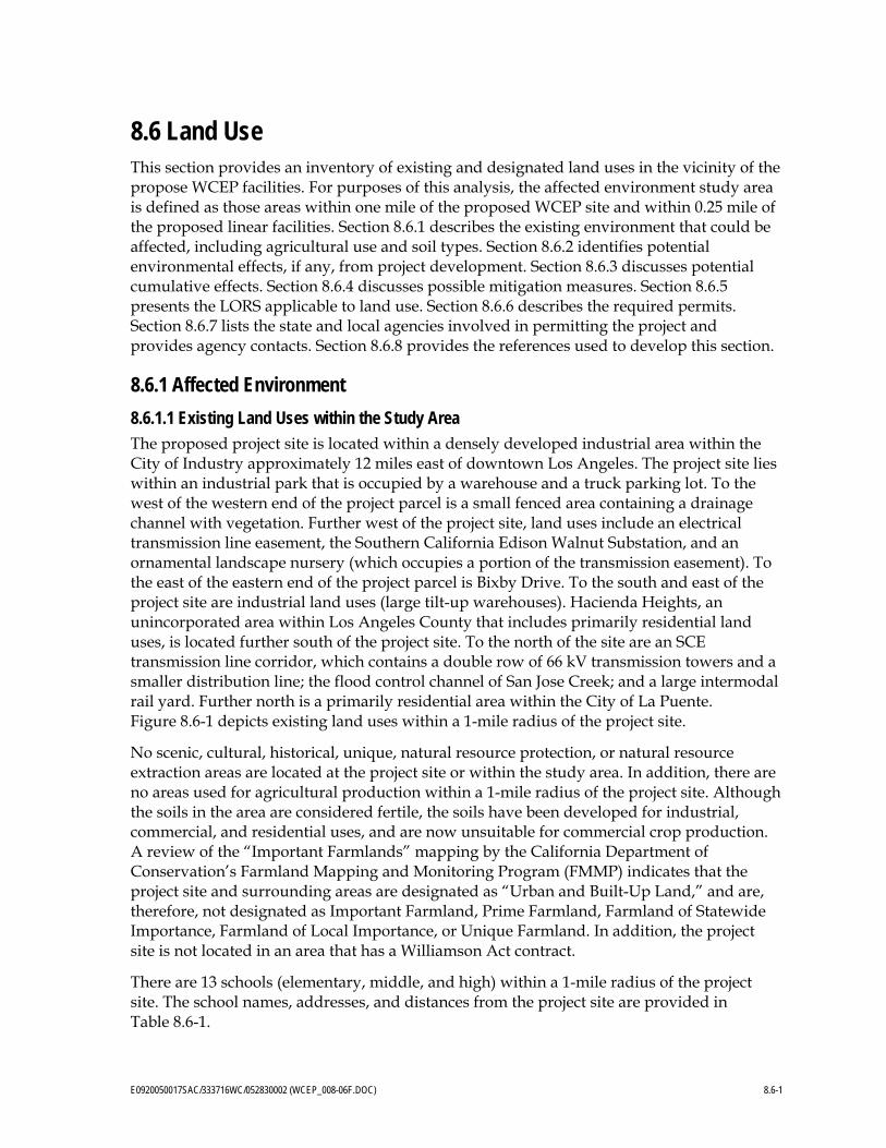
8.6.1.1 Existing Land Uses within the Study Area The proposed project site is located within a densely developed industrial area within the City of Industry approximately 12 miles east of downtown Los Angeles. The project site lies within an industrial park that is occupied by a warehouse and a truck parking lot. To the west of the western end of the project parcel is a small fenced area containing a drainage channel with vegetation. Further west of the project site, land uses include an electrical transmission line easement, the Southern California Edison Walnut Substation, and an ornamental landscape nursery (which occupies a portion of the transmission easement). To the east of the eastern end of the project parcel is Bixby Drive. To the south and east of the project site are industrial land uses (large tilt-up warehouses). Hacienda Heights, an unincorporated area within Los Angeles County that includes primarily residential land uses, is located further south of the project site. To the north of the site are an SCE transmission line corridor, which contains a double row of 66 kV transmission towers and a smaller distribution line; the flood control channel of San Jose Creek; and a large intermodal rail yard. Further north is a primarily residential area within the City of La Puente. Figure 8.6-1 depicts existing land uses within a 1-mile radius of the project site.
No scenic, cultural, historical, unique, natural resource protection, or natural resource extraction areas are located at the project site or within the study area. In addition, there are no areas used for agricultural production within a 1-mile radius of the project site. Although the soils in the area are considered fertile, the soils have been developed for industrial, commercial, and residential uses, and are now unsuitable for commercial crop production. A review of the “Important Farmlands” mapping by the California Department of Conservation’s Farmland Mapping and Monitoring Program (FMMP) indicates that the project site and surrounding areas are designated as “Urban and Built-Up Land,” and are, therefore, not designated as Important Farmland, Prime Farmland, Farmland of Statewide Importance, Farmland of Local Importance, or Unique Farmland. In addition, the project site is not located in an area that has a Williamson Act contract.
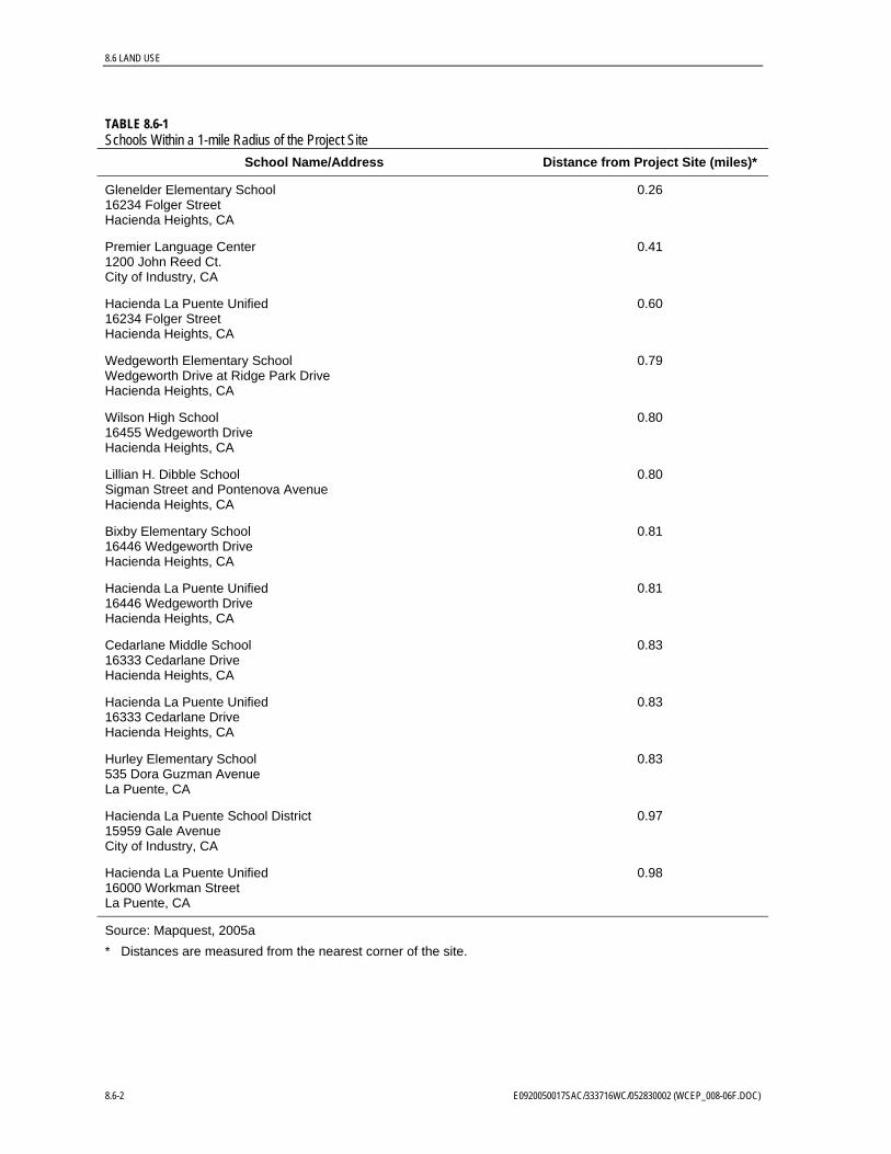
There are 13 schools (elementary, middle, and high) within a 1-mile radius of the project site. The school names, addresses, and distances from the project site are provided in Table 8.6-1.
E0920050017SAC/333716WC/052830002 (WCEP_008-06F.DOC) 8.6-1
8.6 LAND USE
TABLE 8.6-1 Schools Within a 1-mile Radius of the Project Site
School Name/Address Distance from Project Site (miles)*
Glenelder Elementary School 16234 Folger Street Hacienda Heights, CA
0.26
Premier Language Center 1200 John Reed Ct. City of Industry, CA
0.41
Hacienda La Puente Unified 16234 Folger Street Hacienda Heights, CA
0.60
Wedgeworth Elementary School Wedgeworth Drive at Ridge Park Drive Hacienda Heights, CA
0.79
Wilson High School 16455 Wedgeworth Drive Hacienda Heights, CA
0.80
Lillian H. Dibble School Sigman Street and Pontenova Avenue Hacienda Heights, CA
0.80
Bixby Elementary School 16446 Wedgeworth Drive Hacienda Heights, CA
0.81
Hacienda La Puente Unified 16446 Wedgeworth Drive Hacienda Heights, CA
0.81
Cedarlane Middle School 16333 Cedarlane Drive Hacienda Heights, CA
0.83
Hacienda La Puente Unified 16333 Cedarlane Drive Hacienda Heights, CA
0.83
Hurley Elementary School 535 Dora Guzman Avenue La Puente, CA
0.83
Hacienda La Puente School District 15959 Gale Avenue City of Industry, CA
0.97
Hacienda La Puente Unified 16000 Workman Street La Puente, CA
0.98
Source: Mapquest, 2005a * Distances are measured from the nearest corner of the site.
8.6-2 E0920050017SAC/333716WC/052830002 (WCEP_008-06F.DOC)

City of La Puente
City of Industry
Los Angeles County(Hacienda Heights)
City of Industry
Valley BlvdSti
mson
Ave
Chestnut St
East Gale Ave
Azus
a Ave
nue
Colima Road
Halliburton Road
Hacie
nda B
lvd
·|}þ60
FIGURE 8.6-1EXISTING LAND USES WITHIN ONEMILE OF PROJECT SITEWALNUT CREEK ENERGY PARKCITY OF INDUSTRY, CALIFORNIA
SAC \\GLACIER\SACGIS\CHESTNUT_CCEP\SOURCEDATA\MXDS\LANDUSE.MXD FIG8.6-1_LANDUSE.PDF 11/01/2005 11:29:32
0 2,000Feet
LEGENDProject Location1mi BufferCity Boundary
Land UseCommercialGolf CourseGovernmentIndustrialOpen SpaceParkResidentialSchoolWater Tank
SCALE: 1:24,000
¦
8.6 LAND USE
There is one place of worship within a 1-mile radius of the project site. This is the United Chinese Christian Center, 16152 Gale Avenue, Hacienda Heights. It is approximately 0.71 miles from the project site.
8.6.1.2 General Plan Land Use Designations within the Study Area
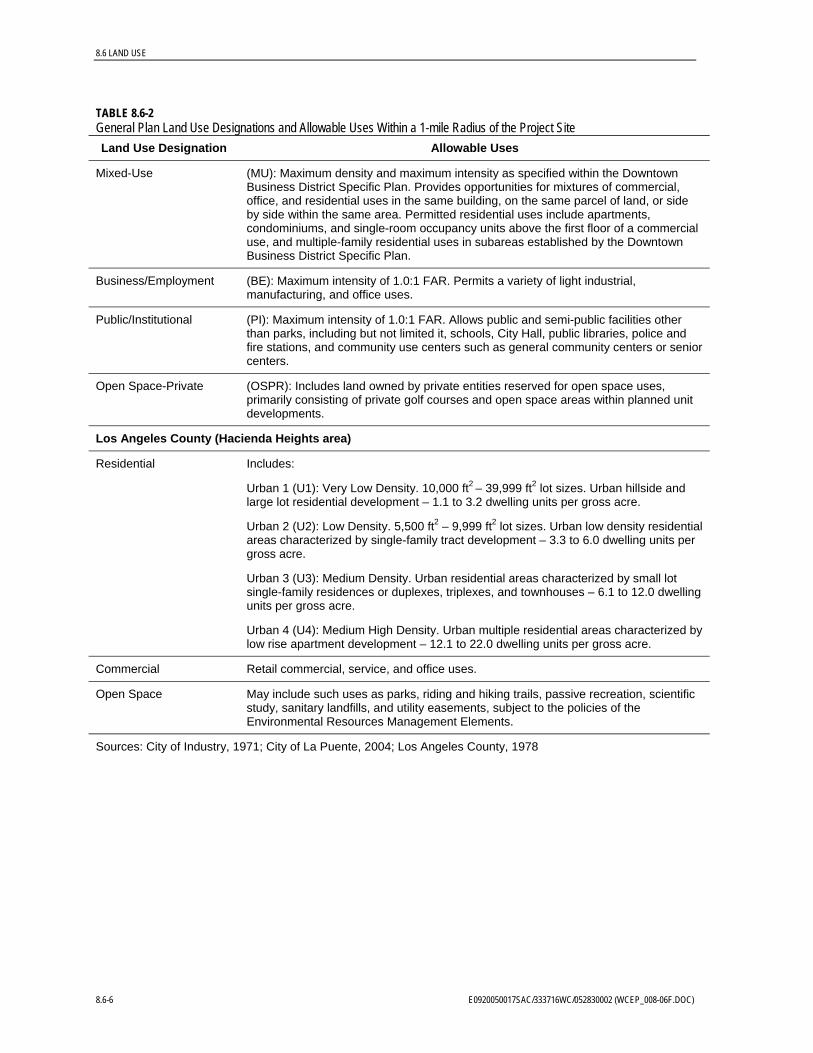
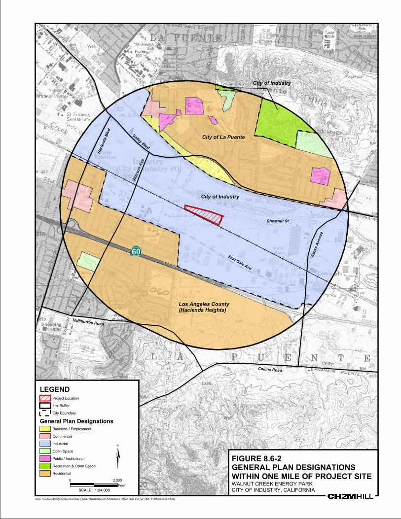
The General Plan land use designations and their associated allowable uses for land that is within a 1-mile radius of the project site are listed in Table 8.6-2. The distribution of these land uses relative to the project site is shown on Figure 8.6-2.
The proposed project is analyzed in this AFC in terms of its conformity with land use designations and policies described in the City of Industry General Plan (City of Industry, 1971) because the project is located entirely within the City of Industry’s jurisdiction. In addition, a brief discussion of the proposed zoning and land use designations and policies described in the City of La Puente and Los Angeles County (for Hacienda Heights) General Plans is also provided because these jurisdictions have land planning authority over land within a 1-mile radius of the project site.
TABLE 8.6-2 General Plan Land Use Designations and Allowable Uses Within a 1-mile Radius of the Project Site
Land Use Designation Allowable Uses
City of Industry
Industrial Includes manufacturing, distribution, and industrial activities.
Recreation & Open Space
Includes park, recreation, and conservation purposes; the land is to be used for recreational and civic needs. Golf is an essential element of the recreational program.
City of La Puente
Residential Includes:
Low Density (LDR): Maximum density of 7 dwelling units per net acre, consisting primarily of detached single-family dwellings on individual lots.
Medium Density (MDR): Maximum density of 14 dwelling units per net acre, consisting of small-lot detached single-family homes, duplexes, triplexes, garden apartments, planned developments, and townhomes.
Medium High Density (MHDR): Maximum density of 18 dwelling units per net acre, allowing for moderate-density apartments, townhomes, condominiums, and planned unit developments.
High Density (HDR): Maximum density of 26 dwelling units per net acre, accommodating higher-intensity multiple-family dwellings where adequate support infrastructure exists. Housing units typically consist of apartments, planned unit developments, condominiums, and townhomes.
Commercial General Commercial (GC): Maximum intensity of 0.75:1 floor area ratio (FAR) along Hacienda/Glendora Corridor and Amar Road, and 1.0:1 FAR at neighborhood centers at North Puente/Amar and Valley/Azusa. Permits a wide range of retail, wholesale, and services uses, as well as shopping and office professional complexes.
E0920050017SAC/333716WC/052830002 (WCEP_008-06F.DOC) 8.6-5
8.6 LAND USE
TABLE 8.6-2 General Plan Land Use Designations and Allowable Uses Within a 1-mile Radius of the Project Site
Land Use Designation Allowable Uses
Mixed-Use (MU): Maximum density and maximum intensity as specified within the Downtown Business District Specific Plan. Provides opportunities for mixtures of commercial, office, and residential uses in the same building, on the same parcel of land, or side by side within the same area. Permitted residential uses include apartments, condominiums, and single-room occupancy units above the first floor of a commercial use, and multiple-family residential uses in subareas established by the Downtown Business District Specific Plan.
Business/Employment (BE): Maximum intensity of 1.0:1 FAR. Permits a variety of light industrial, manufacturing, and office uses.
Public/Institutional (PI): Maximum intensity of 1.0:1 FAR. Allows public and semi-public facilities other than parks, including but not limited it, schools, City Hall, public libraries, police and fire stations, and community use centers such as general community centers or senior centers.
Open Space-Private (OSPR): Includes land owned by private entities reserved for open space uses, primarily consisting of private golf courses and open space areas within planned unit developments.
Los Angeles County (Hacienda Heights area)
Residential Includes:
Urban 1 (U1): Very Low Density. 10,000 ft2 – 39,999 ft2 lot sizes. Urban hillside and large lot residential development – 1.1 to 3.2 dwelling units per gross acre.
Urban 2 (U2): Low Density. 5,500 ft2 – 9,999 ft2 lot sizes. Urban low density residential areas characterized by single-family tract development – 3.3 to 6.0 dwelling units per gross acre.
Urban 3 (U3): Medium Density. Urban residential areas characterized by small lot single-family residences or duplexes, triplexes, and townhouses – 6.1 to 12.0 dwelling units per gross acre.
Urban 4 (U4): Medium High Density. Urban multiple residential areas characterized by low rise apartment development – 12.1 to 22.0 dwelling units per gross acre.
Commercial Retail commercial, service, and office uses.
Open Space May include such uses as parks, riding and hiking trails, passive recreation, scientific study, sanitary landfills, and utility easements, subject to the policies of the Environmental Resources Management Elements.
Sources: City of Industry, 1971; City of La Puente, 2004; Los Angeles County, 1978
8.6-6 E0920050017SAC/333716WC/052830002 (WCEP_008-06F.DOC)
City of La Puente
City of Industry
Los Angeles County(Hacienda Heights)
City of Industry
Valley Blvd
Stims
on Av
e
Chestnut St
East Gale Ave
Hacie
nda B
lvd
Azus
a Ave
nue
Colima Road
Halliburton Road
·|}þ60
FIGURE 8.6-2GENERAL PLAN DESIGNATIONSWITHIN ONE MILE OF PROJECT SITEWALNUT CREEK ENERGY PARKCITY OF INDUSTRY, CALIFORNIA
SAC \\GLACIER\SACGIS\CHESTNUT_CCEP\SOURCEDATA\MXDS\GP.MXD FIG8.6-2_GP.PDF 11/01/2005 09:41:46
0 2,000Feet
LEGENDProject Location1mi BufferCity Boundary
General Plan DesignationsBusiness / EmploymentCommercialIndustrialOpen SpacePublic / InstitutionalRecreation & Open SpaceResidential
SCALE: 1:24,000
¦

8.6 LAND USE
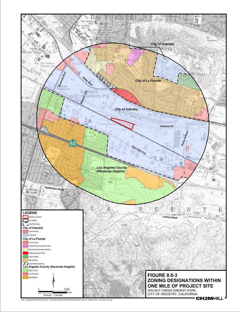
8.6.1.3 Zoning Designations within the Study Area
The zoning designations for land that is within a 1-mile radius of the project site are listed in Table 8.6-3. The distribution of the zoning relative to the project site is shown on Figure 8.6-3.
TABLE 8.6-3 Zoning Designations Within a 1-mile Radius of the Project Site
Zoning Designation
City of Industry
Industrial: Industrial – Public Building, Industrial w/a Manufacturing-Commercial Overlay
Commercial
City of La Puente
Residential: One-family Residential (R-1), Multiple-family (low) (R-2), Multiple-family (medium) (R-3), Multiple-family (high) (R-4), One-family Residential – Estate (R-E), One-family Residential – Suburban (R-S)
Commercial: General Commercial (C-2), Commercial Manufacturing (C-M)
Light Manufacturing: (M-1)
Downtown Business District: (DBD)
Office Business Park: (OBP)
Open Space: (OS)
Cottrell Ranch Specific Plan
Los Angeles County (Hacienda Heights area)
Residential: Single Family Residential Zone (R-1-6000), Limited Multiple Residence Zone (R-3), Residential Agricultural Zone (R-A-7500), (R-A-10000), Residential Planned Development Zone (RPD-6000-15U)
Commercial: Restricted Business Zone (C-1), Unlimited Commercial Zone (C-2-BE), (C-3-BE), Commercial Planned Development (CPD)
Agricultural: Light Agricultural Zone (A-1-6000) and (A-1-7500)
Sources: City of Industry, Undated; City of La Puente, 1993; Los Angeles County, Undated
8.6.1.4 Recent Discretionary Reviews by Public Agencies Within 1 mile of the proposed project site, the City of Industry, the City of La Puente, and Los Angeles County1 have jurisdiction over land use planning. Table 8.6A-1 in Appendix 8.6A lists the projects that have been submitted for review to and/or approved by those planning agencies within the past 18 months. The list of discretionary reviews through these three agencies includes large projects and very small ones. There are 47 entries for City of Industry, 24 for the City of La Puente, and 44 for Los Angeles County (Hacienda Heights).
As shown in Table 8.6A-1, the vast majority of the projects that have been reviewed by the City of Industry in the past 18 months are commercial and industrial developments. In the City of La Puente, the majority of reviewed projects are small residential or commercial/ office infill developments and modifications to existing structures. In Hacienda Heights, the majority of projects include modifications to existing residential structures and infrastructure improvements.
1 Hacienda Heights, within Los Angeles County, is the land use planning area within 1 mile of the project site.
E0920050017SAC/333716WC/052830002 (WCEP_008-06F.DOC) 8.6-9
8.6 LAND USE
8.6.1.5 Future Growth Trends
Land use and growth trends identified for the study area are based on population estimates and projections, current land use plans, and approved development projects within that area.
8.6.1.5.1 Population Estimates and Projections for the Study Area The City of Industry’s 2000 population was 777 (U.S. Census Bureau, 2000a). As of January 1, 2005, the City’s population was estimated at 840 (California Department of Finance, 2005), indicating an annual growth rate of between 0.5 and 0.9 percent.
The City of La Puente’s 2000 population was 41,063 (U.S. Census Bureau, 2000b). As of January 1, 2005, the City’s population was estimated at 43,360 (California Department of Finance, 2005), indicating an annual growth rate of between.001 and 1.4 percent.
Hacienda Heights had a population of 52,354 in 1990 (U.S. Census Bureau, 1990), and a 2000 population of 53,122 (U.S. Census Bureau, 2000c), indicating a 1.5 percent growth rate during that 10-year period.
8.6.1.5.2 Current Land Use Plans for the Study Area Comparing the existing land use map (Figure 8.6-1) with the General Plan land use designation map (Figure 8.6-2) indicates that the study area has developed very similarly into the land uses that were planned by the City of Industry, the City of La Puente, and Los Angeles County (for Hacienda Heights). The primary difference is the open space-designated tract of land in the City of La Puente that has developed into residential land uses.
8.6.1.5.3 Conclusions Because of the low annual population growth rate in the study area, relatively small amount of undeveloped open space land in the area that is planned and available for development, and types of developments that have been submitted to and reviewed by the local planning agencies, it appears that the study area is nearly completely developed and the area’s growth rate will continue to decline as it has over the past several years. There is relatively little opportunity in the area for infill development.
8.6.2 Environmental Consequences
8.6.2.1 Significance Criteria
Significance criteria for impacts to land use were determined through review of applicable state and local regulations. Because the Warren-Alquist Act is equivalent to a CEQA review, the following criteria developed from the CEQA Guidelines and the CEQA Checklist were used to evaluate the potential environmental impacts of the project:
• Will the project physically divide an established community?
• Will the project conflict with any applicable land use plan, policy, or regulation of an agency with jurisdiction over the project (including, but not limited to, the general plan, specific plan, local coastal program, or zoning ordinance) adopted for the purpose of avoiding or mitigating an environmental effect?
• Will the project conflict with any applicable habitat conservation plan or natural community conservation plan?
8.6-10 E0920050017SAC/333716WC/052830002 (WCEP_008-06F.DOC)
City of La Puente
City of Industry
Los Angeles County(Hacienda Heights)
City of Industry
Valley BlvdSti
mson
Ave
Chestnut St
East Gale Ave
Hacie
nda B
lvd
Azus
a Ave
nue
Colima Road
Halliburton Road
·|}þ60
FIGURE 8.6-3ZONING DESIGNATIONS WITHIN ONE MILE OF PROJECT SITE WALNUT CREEK ENERGY PARKCITY OF INDUSTRY, CALIFORNIA
SAC \\GLACIER\SACGIS\CHESTNUT_CCEP\SOURCEDATA\MXDS\ZONING.MXD FIG8.6-3_ZONING.PDF 11/01/2005 16:03:42
0 2,000Feet
SCALE: 1:24,000
¦
LEGEND1mi BufferCity Boundary
City of IndustryCommercialIndustrial
City of La PuenteCommercialCottrell Ranch Specific PlanDowntown Business DistrictOffice Business ParkOpen SpaceResidential
Los Angeles County (Hacienda Heights)AgriculturalCommercialResidential
Light Manufacturing
Project Location
8.6 LAND USE
• Will the project convert prime farmland, unique farmland, or farmland of statewide importance (Farmland), as shown on the maps prepared pursuant to the Farmland Mapping and Monitoring Program of the California Resources Agency, to nonagricultural use?
• Will the project involve other changes in the existing environment, which, given their location and nature, could result in conversion of Farmland to nonagricultural use?
8.6.2.2 Potential Effects on Land Use During Project Construction and Operation
The presence of the proposed project would not physically divide the City of Industry community. Although the project site is not located near a jurisdictional boundary of the City of Industry, it is located just south of a high voltage transmission line easement, drainage channel, and railroad yard. It is located just north of railroad tracks, west of warehouse industrial development, and east of a high voltage transmission line easement. As such, the site is located within an existing industrial area, and the proposed use is compatible with the existing surrounding uses.
Implementation of the project would result in an industrial development being constructed in the City of Industry on land that is General Plan-designated and zoned for industrial use by the City of Industry. The project constitutes the type of development and land use encouraged by the City of Industry’s goals and objectives. The project is consistent with current land use and zoning designations for the site. The site is currently being used for industrial purposes, and based on the goals and objectives of the City of Industry General Plan, the site would continue to be used for industrial purposes, regardless of the proposed project.
The City of Industry does not currently have an approved habitat conservation plan or natural community conservation plan. Therefore, the project would not conflict with the goals of such a plan.
There are no areas used for agricultural production within a 1-mile radius of the project site, and the soils in the area are considered unsuitable for commercial crop production because of the industrial, commercial, and residential development in the area. The project site and surrounding areas are designated as “Urban and Built-Up Land” by the California Department of Conservation, and are, therefore, not designated as Important Farmland, Prime Farmland, Farmland of Statewide Importance, Farmland of Local Importance, or Unique Farmland. In addition, the project site is not located in an area that has a Williamson Act contract. Therefore, implementation of the project would not result in the conversion of Prime Farmland, Unique Farmland, or Farmland of Statewide Importance to nonagricultural use. In addition, project implementation would not bring about any other changes in the environment that could result in the conversion of farmland to nonagricultural use.
8.6.2.3 Compatibility with Existing and Designated Land Uses and Applicable Planning Policies
The existing land use, the City of Industry General Plan land use designation, and the City of Industry zoning designation of the project site are “Industrial.” The proposed project is considered an industrial land use. Therefore, the proposed use is both consistent and compatible with existing and planned land uses for the project site.
E0920050017SAC/333716WC/052830002 (WCEP_008-06F.DOC) 8.6-13
8.6 LAND USE
8.6-14 E0920050017SAC/333716WC/052830002 (WCEP_008-06F.DOC)
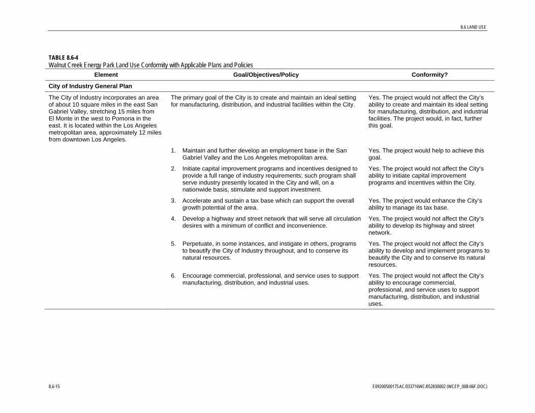
The proposed project conforms with the goals and policies of applicable plans. Table 8.6-4 summarizes the project’s conformity with these plans.
8.6.3 Cumulative Impacts The CEQA Guidelines (Section 15355) define cumulative impacts as “two or more individual effects which, when considered together, are considerable or which compound or increase other environmental impacts.”
The CEQA Guidelines further note that:
The cumulative impact from several projects is the change in the environment which results from the incremental impact of the project when added to other closely related past, present, and reasonably foreseeable probable future projects. Cumulative impacts can result from individually minor, but collectively significant, projects taking place over a period of time.
As discussed above, the proposed project conforms with the City of Industry’s major goals and objectives for industrial development and will be sited in an areas reserved for such purposes. The proposed project is consistent with the current land use designation and zoning district for the site, and is also conforms with land use policies relevant to the project. Therefore, the proposed project will not contribute to a cumulative impact on land uses in the project vicinity.
In addition, implementation of the proposed project would not affect lands that are designated Important Farmlands, such as Prime Farmland, Farmland of Statewide and Local Importance, and Unique Farmlands because the project site and surround area is classified as Urban and Built-Up Land. Therefore, no potential cumulative impacts to conversion of agricultural resources in Los Angeles County associated with the proposed project are expected.
8.6.4 Mitigation Measures No significant land use impacts are anticipated from implementation of the proposed project. Therefore, no mitigation measures are proposed. Project implementation will be consistent with City of Industry planning regulations, however. Specifically, a site plan will be prepared and submitted to the City of Industry for review and comment and CEC Compliance Project Manager for review and approval before construction begins. The site plan will comply with all applicable provisions of the City of Industry Municipal Code (1996).
8.6.5 Laws, Ordinances, Regulations, and Standards This section discusses the land use LORS that apply to the proposed project.
8.6.5.1 Federal LORS
No federal LORS for land use are applicable to the site or proposed project.
8.6 LAND USE
TABLE 8.6-4 Walnut Creek Energy Park Land Use Conformity with Applicable Plans and Policies
Element Goal/Objectives/Policy Conformity?
City of Industry General Plan
The City of Industry incorporates an area of about 10 square miles in the east San Gabriel Valley, stretching 15 miles from El Monte in the west to Pomona in the east. It is located within the Los Angeles metropolitan area, approximately 12 miles from downtown Los Angeles.
The primary goal of the City is to create and maintain an ideal setting for manufacturing, distribution, and industrial facilities within the City.
Yes. The project would not affect the City’s ability to create and maintain its ideal setting for manufacturing, distribution, and industrial facilities. The project would, in fact, further this goal.
1. Maintain and further develop an employment base in the San Gabriel Valley and the Los Angeles metropolitan area.
Yes. The project would help to achieve this goal.
2. Initiate capital improvement programs and incentives designed to provide a full range of industry requirements; such program shall serve industry presently located in the City and will, on a nationwide basis, stimulate and support investment.
Yes. The project would not affect the City’s ability to initiate capital improvement programs and incentives within the City.
3. Accelerate and sustain a tax base which can support the overall growth potential of the area.
Yes. The project would enhance the City’s ability to manage its tax base.
4. Develop a highway and street network that will serve all circulation desires with a minimum of conflict and inconvenience.
Yes. The project would not affect the City’s ability to develop its highway and street network.
5. Perpetuate, in some instances, and instigate in others, programs to beautify the City of Industry throughout, and to conserve its natural resources.
Yes. The project would not affect the City’s ability to develop and implement programs to beautify the City and to conserve its natural resources.
6. Encourage commercial, professional, and service uses to support manufacturing, distribution, and industrial uses.
Yes. The project would not affect the City’s ability to encourage commercial, professional, and service uses to support manufacturing, distribution, and industrial uses.
8.6-15 E0920050017SAC/333716WC/052830002 (WCEP_008-06F.DOC)
8.6 LAND USE
TABLE 8.6-4
Element Goal/Objectives/Policy Walnut Creek Energy Park Land Use Conformity with Applicable Plans and Policies
Conformity?
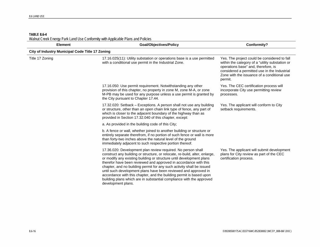
City of Industry Municipal Code Title 17 Zoning
Title 17 Zoning 17.16.025(11): Utility substation or operations base is a use permitted with a conditional use permit in the Industrial Zone.
Yes. The project could be considered to fall within the category of a “utility substation or operations base” and, therefore, is considered a permitted use in the Industrial Zone with the issuance of a conditional use permit.
17.16.050: Use permit requirement. Notwithstanding any other provision of this chapter, no property in zone M, zone M-A, or zone M-PB may be used for any purpose unless a use permit is granted by the City pursuant to Chapter 17.44.
Yes. The CEC certification process will incorporate City use permitting review processes.
17.32.020: Setback – Exceptions. A person shall not use any building or structure, other than an open chain link type of fence, any part of which is closer to the adjacent boundary of the highway than as provided in Section 17.32.040 of this chapter, except:
Yes. The applicant will conform to City setback requirements.
a. As provided in the building code of this City;
b. A fence or wall, whether joined to another building or structure or entirely separate therefrom, if no portion of such fence or wall is more than forty-two inches above the natural level of the ground immediately adjacent to such respective portion thereof.
17.36.020: Development plan review required. No person shall construct any building or structure, or relocate, re-build, alter, enlarge, or modify any existing building or structure until development plans therefor have been reviewed and approved in accordance with this chapter, and no building permit for any such activity shall be issued until such development plans have been reviewed and approved in accordance with this chapter, and the building permit is based upon building plans which are in substantial compliance with the approved development plans.
Yes. The applicant will submit development plans for City review as part of the CEC certification process.
8.6-16 E0920050017SAC/333716WC/052830002 (WCEP_008-06F.DOC)

8.6 LAND USE
TABLE 8.6-4
Element Goal/Objectives/Policy Walnut Creek Energy Park Land Use Conformity with Applicable Plans and Policies
Conformity?
17.44.010: Use permit requirement. Notwithstanding any other provision of this title, no property in the City shall be used for any purpose by any person, corporation, or other business establishment and no existing use shall be changed or altered by any person, corporation, or other business establishment unless a use permit is granted to such person, corporation, or other business establishment by the City for the proposed use pursuant to this chapter.
Yes. The CEC certification process will incorporate City use permitting review processes.
17.56.010 Height of Structures. Except where a lesser maximum height is prescribed either by this title or any other ordinance or by statute, all buildings and structures of every kind and nature in the territory of the City except radio towers and oil derricks shall not exceed 150 feet in height.
Yes. Structures associated with the proposed project are expected to be less than the 150 feet maximum height allowed by the City.
City of La Puente General Plan
The City of La Puente is located 20 miles east of downtown Los Angeles in the San Gabriel Valley. La Puente
The City’s Community Vision is to be:
• A family-oriented community providing a range of public services
Yes. The project would have no effect on the City’s ability to provide public services.
• An attractive community of homes and neighborhoods Yes. The project would have no effect on the City’s ability to provide an attractive community.
Yes. The project would have no effect on the City’s ability to provide opportunities for businesses.
• A community that provides opportunities for businesses to be successful
Yes. The project would have no effect on the City’s ability to provide a safe living environment.
• A safe place to live, work, and shop
Yes. The project would have no effect on the City’s ability to provide varied housing options.
• A balanced community that promotes varied housing options
Yes. The project would have no effect on the City’s ability to provide a mobile and accessible community.
• A mobile and accessible community
E0920050017SAC/333716WC/052830002 (WCEP_008-06F.DOC) 8.6-17
8.6 LAND USE
TABLE 8.6-4
Element Goal/Objectives/Policy Walnut Creek Energy Park Land Use Conformity with Applicable Plans and Policies
Conformity?
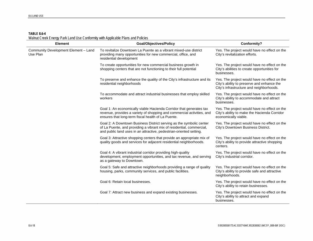
Community Development Element – Land Use Plan
To revitalize Downtown La Puente as a vibrant mixed-use district providing many opportunities for new commercial, office, and residential development
Yes. The project would have no effect on the City’s revitalization efforts.
To create opportunities for new commercial business growth in shopping centers that are not functioning to their full potential
Yes. The project would have no effect on the City’s abilities to create opportunities for businesses.
To preserve and enhance the quality of the City’s infrastructure and its residential neighborhoods
Yes. The project would have no effect on the City’s ability to preserve and enhance the City’s infrastructure and neighborhoods.
To accommodate and attract industrial businesses that employ skilled workers
Yes. The project would have no effect on the City’s ability to accommodate and attract businesses.
Goal 1: An economically viable Hacienda Corridor that generates tax revenue, provides a variety of shopping and commercial activities, and ensures that long-term fiscal health of La Puente.
Yes. The project would have no effect on the City’s ability to make the Hacienda Corridor economically viable.
Goal 2: A Downtown Business District serving as the symbolic center of La Puente, and providing a vibrant mix of residential, commercial, and public land uses in an attractive, pedestrian-oriented setting.
Yes. The project would have no effect on the City’s Downtown Business District.
Goal 3: Attractive shopping centers that provide an appropriate mix of quality goods and services for adjacent residential neighborhoods.
Yes. The project would have no effect on the City’s ability to provide attractive shopping centers.
Goal 4: A vibrant industrial corridor providing high-quality development, employment opportunities, and tax revenue, and serving as a gateway to Downtown.
Yes. The project would have no effect on the City’s industrial corridor.
Goal 5: Safe and attractive neighborhoods providing a range of quality housing, parks, community services, and public facilities.
Yes. The project would have no effect on the City’s ability to provide safe and attractive neighborhoods.
Goal 6: Retain local businesses. Yes. The project would have no effect on the City’s ability to retain businesses.
Goal 7: Attract new business and expand existing businesses. Yes. The project would have no effect on the City’s ability to attract and expand businesses.
8.6-18 E0920050017SAC/333716WC/052830002 (WCEP_008-06F.DOC)
8.6 LAND USE
TABLE 8.6-4
Element Goal/Objectives/Policy Walnut Creek Energy Park Land Use Conformity with Applicable Plans and Policies
Conformity?
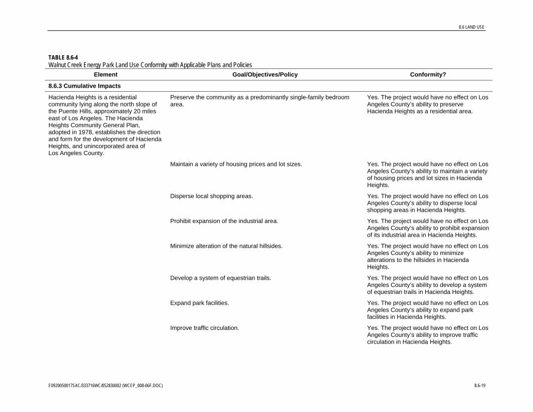
8.6.3 Cumulative Impacts
Hacienda Heights is a residential community lying along the north slope of the Puente Hills, approximately 20 miles east of Los Angeles. The Hacienda Heights Community General Plan, adopted in 1978, establishes the direction and form for the development of Hacienda Heights, and unincorporated area of Los Angeles County.
Preserve the community as a predominantly single-family bedroom area.
Yes. The project would have no effect on Los Angeles County’s ability to preserve Hacienda Heights as a residential area.
Maintain a variety of housing prices and lot sizes. Yes. The project would have no effect on Los Angeles County’s ability to maintain a variety of housing prices and lot sizes in Hacienda Heights.
Disperse local shopping areas. Yes. The project would have no effect on Los Angeles County’s ability to disperse local shopping areas in Hacienda Heights.
Prohibit expansion of the industrial area. Yes. The project would have no effect on Los Angeles County’s ability to prohibit expansion of its industrial area in Hacienda Heights.
Minimize alteration of the natural hillsides. Yes. The project would have no effect on Los Angeles County’s ability to minimize alterations to the hillsides in Hacienda Heights.
Develop a system of equestrian trails. Yes. The project would have no effect on Los Angeles County’s ability to develop a system of equestrian trails in Hacienda Heights.
Expand park facilities. Yes. The project would have no effect on Los Angeles County’s ability to expand park facilities in Hacienda Heights.
Improve traffic circulation. Yes. The project would have no effect on Los Angeles County’s ability to improve traffic circulation in Hacienda Heights.
E0920050017SAC/333716WC/052830002 (WCEP_008-06F.DOC) 8.6-19

8.6 LAND USE
TABLE 8.6-4
Element Goal/Objectives/Policy Walnut Creek Energy Park Land Use Conformity with Applicable Plans and Policies
Conformity?
Land Use 1. Prohibit residential uses in industrial areas. Residential uses in Commercial areas are allowed only in conjunction with commercial uses.
Yes. The project would have no effect on Los Angeles County’s ability to prohibit residential uses in industrial areas in Hacienda Heights.
2. Prohibit mobilehome parks in non-urban areas. Yes. The project would have no effect on Los Angeles County’s ability to prohibit mobilehome parks in non-urban areas in Hacienda Heights.
3. Permit interim low intensity recreational and associated uses of a portion of the future landfill area subject to the following conditions:
Yes. The project would have no effect on Los Angeles County’s ability to permit recreational and associated uses on the future landfill in Hacienda Heights.
a. Direct access from Seventh Avenue to the Skyline Trail will be provided for equestrian and hiking use, via the undeveloped acreage southwest of the intersection of Seventh Avenue and Orange Grove Avenue and the portion of the landfill site lying southwesterly of homes on Old Canyon Drive.
b. Allow low-intensity recreational use of that portion of the landfill site lying southwest of homes on Old Canyon Drive. The recreational use will emphasize maintenance of the natural environment with minimal facilities for horseback riding, hiking, and picnicking. An unpaved parking area will be included off the landfill site on the Seventh Avenue right-of-way.
c. Adequate firebreaks must be provided to protect the residential neighborhoods adjacent to the landfill site.
d. Use of that portion of the site immediately adjacent to existing residential neighborhoods shall be limited to livestock grazing and/or wildlife preserve.
4. Require dedication of local park space as a condition for any residential densities over six units per acre as follows:
Yes. The project would have no effect on Los Angeles County’s ability to manage local park space allocations in Hacienda Heights.
a. Five acres of park space on the 26-acre parcel at the northeast corner of Halliburton Road and Colima Road.
8.6-20 E0920050017SAC/333716WC/052830002 (WCEP_008-06F.DOC)
8.6 LAND USE
TABLE 8.6-4
Element Goal/Objectives/Policy Walnut Creek Energy Park Land Use Conformity with Applicable Plans and Policies
Conformity?
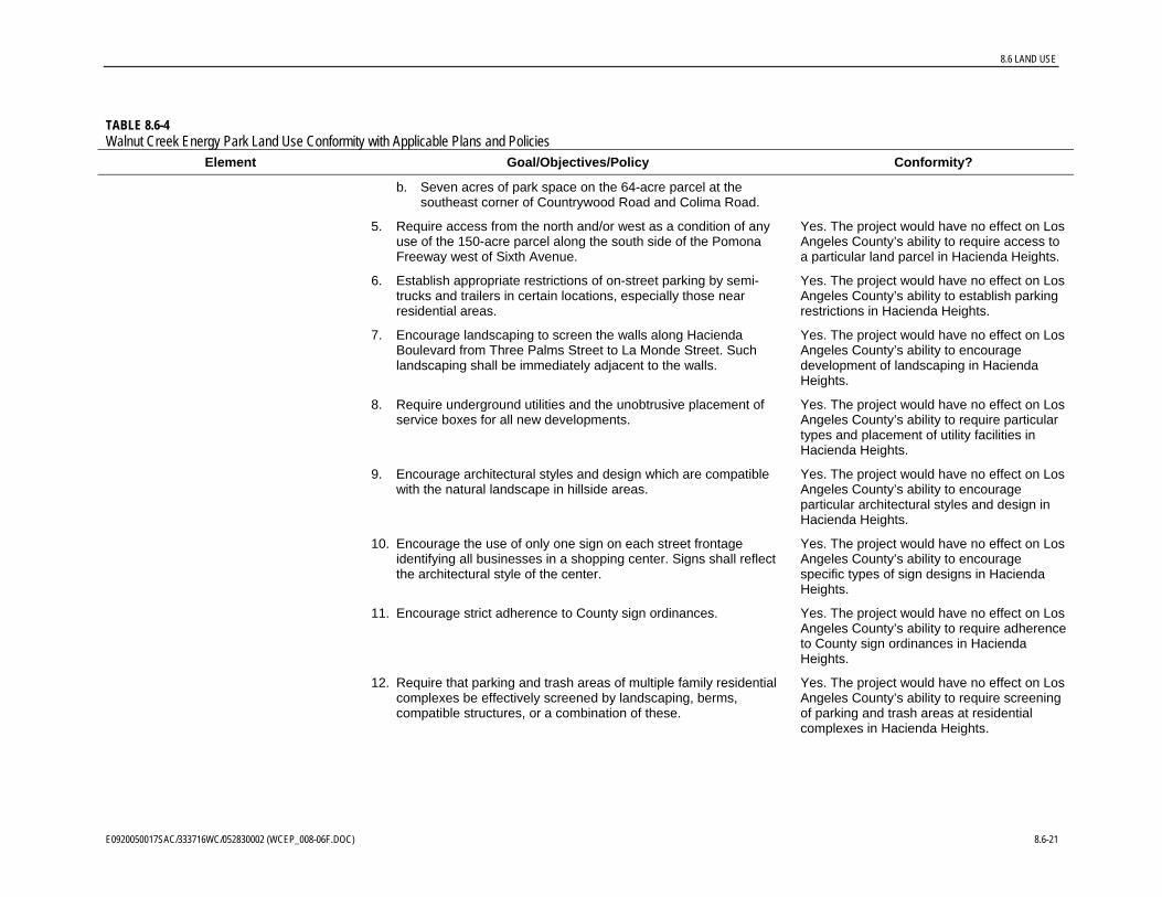
b. Seven acres of park space on the 64-acre parcel at the southeast corner of Countrywood Road and Colima Road.
5. Require access from the north and/or west as a condition of any use of the 150-acre parcel along the south side of the Pomona Freeway west of Sixth Avenue.
Yes. The project would have no effect on Los Angeles County’s ability to require access to a particular land parcel in Hacienda Heights.
6. Establish appropriate restrictions of on-street parking by semi-trucks and trailers in certain locations, especially those near residential areas.
Yes. The project would have no effect on Los Angeles County’s ability to establish parking restrictions in Hacienda Heights.
7. Encourage landscaping to screen the walls along Hacienda Boulevard from Three Palms Street to La Monde Street. Such landscaping shall be immediately adjacent to the walls.
Yes. The project would have no effect on Los Angeles County’s ability to encourage development of landscaping in Hacienda Heights.
8. Require underground utilities and the unobtrusive placement of service boxes for all new developments.
Yes. The project would have no effect on Los Angeles County’s ability to require particular types and placement of utility facilities in Hacienda Heights.
9. Encourage architectural styles and design which are compatible with the natural landscape in hillside areas.
Yes. The project would have no effect on Los Angeles County’s ability to encourage particular architectural styles and design in Hacienda Heights.
10. Encourage the use of only one sign on each street frontage identifying all businesses in a shopping center. Signs shall reflect the architectural style of the center.
Yes. The project would have no effect on Los Angeles County’s ability to encourage specific types of sign designs in Hacienda Heights.
11. Encourage strict adherence to County sign ordinances. Yes. The project would have no effect on Los Angeles County’s ability to require adherence to County sign ordinances in Hacienda Heights.
12. Require that parking and trash areas of multiple family residential complexes be effectively screened by landscaping, berms, compatible structures, or a combination of these.
Yes. The project would have no effect on Los Angeles County’s ability to require screening of parking and trash areas at residential complexes in Hacienda Heights.
E0920050017SAC/333716WC/052830002 (WCEP_008-06F.DOC) 8.6-21
8.6-22 E0920050017SAC/333716WC/052830002 (WCEP_008-06F.DOC)
TABLE 8.6-4
Element Goal/Objectives/Policy Conformity?
6 LAND USE
Walnut Creek Energy Park Land Use Conformity with Applicable Plans and Policies
Sources: City of Industry, 1971 and 1996; City of La Puente, 2004; Los Angeles County, 1978
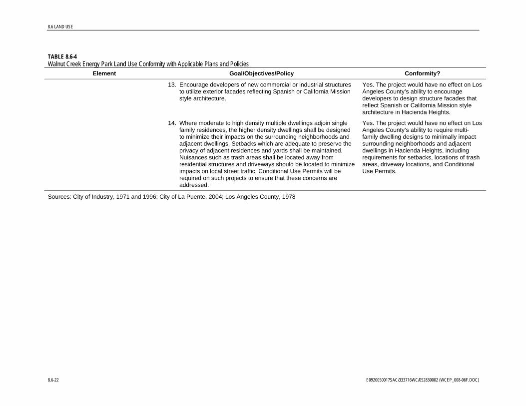
Yes. The project would have no effect on Los Angeles County’s ability to encourage developers to design structure facades that reflect Spanish or California Mission style architecture in Hacienda Heights.
Yes. The project would have no effect on Los Angeles County’s ability to require multi-family dwelling designs to minimally impact surrounding neighborhoods and adjacent dwellings in Hacienda Heights, including requirements for setbacks, locations of trash areas, driveway locations, and Conditional Use Permits.
14. Where moderate to high density multiple dwellings adjoin single family residences, the higher density dwellings shall be designed to minimize their impacts on the surrounding neighborhoods and adjacent dwellings. Setbacks which are adequate to preserve the privacy of adjacent residences and yards shall be maintained. Nuisances such as trash areas shall be located away from residential structures and driveways should be located to minimize impacts on local street traffic. Conditional Use Permits will be required on such projects to ensure that these concerns are addressed.
13. Encourage developers of new commercial or industrial structures to utilize exterior facades reflecting Spanish or California Mission style architecture.
8.
8.6 LAND USE
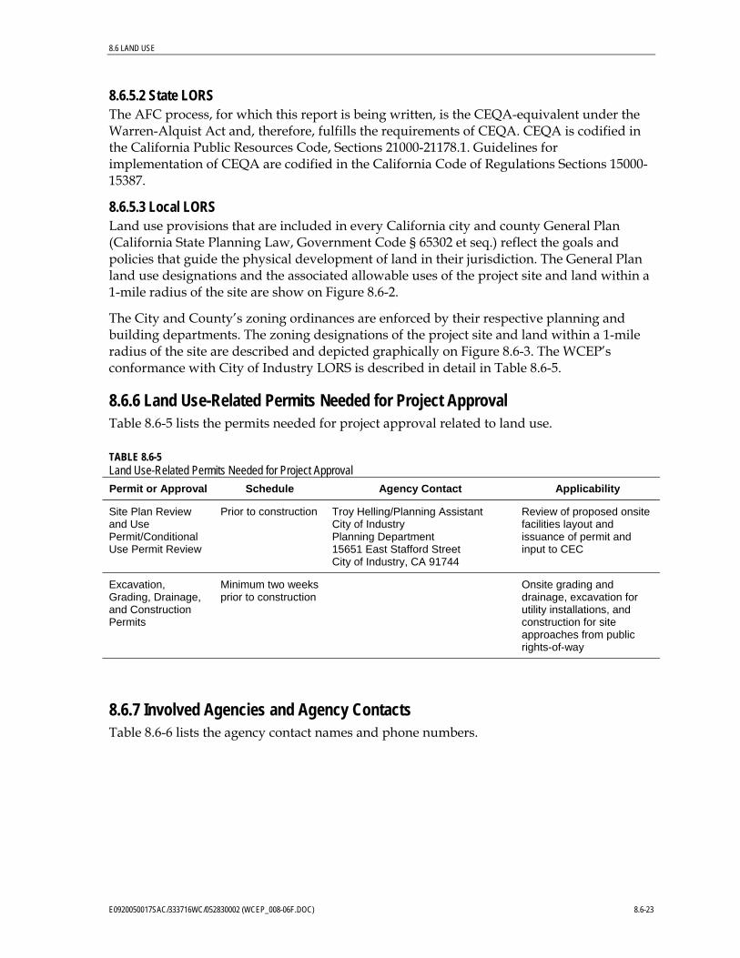
8.6.5.2 State LORS The AFC process, for which this report is being written, is the CEQA-equivalent under the Warren-Alquist Act and, therefore, fulfills the requirements of CEQA. CEQA is codified in the California Public Resources Code, Sections 21000-21178.1. Guidelines for implementation of CEQA are codified in the California Code of Regulations Sections 15000-15387.
8.6.5.3 Local LORS Land use provisions that are included in every California city and county General Plan (California State Planning Law, Government Code § 65302 et seq.) reflect the goals and policies that guide the physical development of land in their jurisdiction. The General Plan land use designations and the associated allowable uses of the project site and land within a 1-mile radius of the site are show on Figure 8.6-2.
The City and County’s zoning ordinances are enforced by their respective planning and building departments. The zoning designations of the project site and land within a 1-mile radius of the site are described and depicted graphically on Figure 8.6-3. The WCEP’s conformance with City of Industry LORS is described in detail in Table 8.6-5.
8.6.6 Land Use-Related Permits Needed for Project Approval Table 8.6-5 lists the permits needed for project approval related to land use.
TABLE 8.6-5 Land Use-Related Permits Needed for Project Approval
Permit or Approval Schedule Agency Contact Applicability
Site Plan Review and Use Permit/Conditional Use Permit Review
Prior to construction Troy Helling/Planning Assistant City of Industry Planning Department 15651 East Stafford Street City of Industry, CA 91744
Review of proposed onsite facilities layout and issuance of permit and input to CEC
Excavation, Grading, Drainage, and Construction Permits
Minimum two weeks prior to construction
Onsite grading and drainage, excavation for utility installations, and construction for site approaches from public rights-of-way
8.6.7 Involved Agencies and Agency Contacts Table 8.6-6 lists the agency contact names and phone numbers.
E0920050017SAC/333716WC/052830002 (WCEP_008-06F.DOC) 8.6-23

8.6 LAND USE
TABLE 8.6-6 Involved Agencies and Agency Contacts
Agency Contact/Title Telephone
(626) 333-2211 City of Industry Planning Department 15651 East Stafford Street City of Industry, CA 91744 http://www.cityofindustry.org
Mike Kissell/Planning Director Troy Helling/Planning Assistant
City of La Puente Community Development Department Planning Division 15900 E. Main Street La Puente, CA 91744 http://www.lapuente.org
Jean Yen/Assistant Planner (626) 855-1500
Los Angeles County Department of Regional Planning 320 West Temple Street Los Angeles, CA 90012 http://planning.co.la.ca.us
Mark Child/AICP (213) 974-6425
8.6.8 References Cited and Personal Communications California Department of Finance. 2005. Table 2: E-4 Population Estimates for Cities, Counties and State, 2001-2005 with 2000 DRU Benchmark. Accessed online at http://www.dof.ca.gov on September 13, 2005.
Carreon-Quion, Angelique. Information Systems Analyst. Los Angeles County Department of Regional Planning. 2005. Personal communication with Wendy Haydon/CH2M HILL on September 1, 2, and 12, 2005.
Child, Mark. Los Angeles County Department of Regional Planning. 2005. Personal communication with Wendy Haydon/CH2M HILL on August 31, 2005.
Franchino, Nick. Information Systems Analyst. Los Angeles County Department of Regional Planning. 2005. Personal communication with Wendy Haydon/CH2M HILL on August 31, 2005.
City of Industry. 1996. City Municipal Code, Title 17, Zoning. December.
City of Industry. 1971. The General Plan, City of Industry. May.
City of Industry. Undated. Zoning Map.
City of La Puente. 2004. City of La Puente General Plan. Adopted by Resolution No. 04-4384 on May 18.
City of La Puente. 1993. City of La Puente Zoning Map. Revised March.
Helling, Troy. Planning Assistant. City of Industry. Personal communication with Wendy Haydon/CH2M HILL on August 26, 2005.
8.6-24 E0920050017SAC/333716WC/052830002 (WCEP_008-06F.DOC)
8.6 LAND USE
Kissell, Mike. Planning Director. City of Industry. Personal communication with Wendy Haydon/CH2M HILL on August 26, 2005.
Los Angeles County. 1978. Proposed Hacienda Heights Community General Plan. Adopted October 31.
Los Angeles County. Undated. Hacienda Heights Zoning Map.
Los Angeles County. Undated. Los Angeles, CA County Code. Title 22 Planning and Zoning. Accessed online at http://ordlink.com/codes/ lacounty/_DATA/TITLE22/ index.html on September 1, 2005.
Los Angeles County Department of Regional Planning. 2005. Personal communication with Greg Graber/CH2M HILL on August 26 and September 12, 2005.
Mapquest. 2005a. Schools (K-12) near Chestnut St. & Bixby Dr., City of Industry, CA 91748. Accessed online at http://www.mapquest.com on September 15, 2005.
Mapquest. 2005b. (All) Places of Worship near Chestnut St. & Bixby Dr., City of Industry, CA 91748. Accessed online at http://www.mapquest.com on September 15, 2005.
U.S. Census Bureau. 2000a. Summary File 1 (SF1) and Summary File 3 (SF 3). Census 2000 Demographic Profile Highlights for Industry City, California. Accessed online at http://factfinder.census.gov on September 13, 2005.
U.S. Census Bureau. 2000b. Summary File 1 (SF1) and Summary File 3 (SF 3). Census 2000 Demographic Profile Highlights for La Puente City, California. Accessed online at http://factfinder.census.gov on September 13, 2005.
U.S. Census Bureau. 2000c. Summary File 1 (SF1) and Summary File 3 (SF 3). Census 2000 Demographic Profile Highlights for Hacienda Heights CDP, California. Accessed online at http://factfinder.census.gov on September 13, 2005.
U.S. Census Bureau. 1990. 1990 Census of Population and Housing, Summary Tape File 1 (100% Data) Matrices P1, P3, P5, P6, P8, P11, P15, P16, P23, H1, H2, H3, H5, H8, H10, H18A, H21, H23, H23B, H32, H32B, H41. General Population and Housing Characteristics: 1990, Hacienda Heights CDP, California. Accessed online at http://factfinder.census.gov on September 15, 2005.
Yen, Jean. Assistant Planner. City of La Puente. 2005. Personal communication with Wendy Haydon/CH2M HILL on September 1 and 13, 2005.
E0920050017SAC/333716WC/052830002 (WCEP_008-06F.DOC) 8.6-25


![OSCE dysphagia exams - WordPress.com...PBL 8.6.1 PBL 8.6.1 [Student Case] Trigger Doug Caldwell is a 54-year-old unemployed man with a long history of heartburn who presents to his](https://img.pdfslide.net/doc/110x75/60ff9a05abf63b76a1276258/osce-dysphagia-exams-pbl-861-pbl-861-student-case-trigger-doug-caldwell.jpg)


![CCNA Lab Packet Tracer Activity 8.6.1 [Resolved] part 1.pdf](https://img.pdfslide.net/doc/110x75/55cf9387550346f57b9dbad9/ccna-lab-packet-tracer-activity-861-resolved-part-1pdf.jpg)