Embed Size (px)
Citation preview
Soil Atlas of Africa | Soil Maps Soil Maps | Soil Atlas of Africa82 83
TUNISALGER
Batna
Blida
Granada
Sfax
Oujda
Annaba
Constantine
M†lagaL'Ariana
Oran
S#tif
Ouargla
Touggourt
Bizerte
GuelmaSoukAhras
Almer°a
Tlemcen Biskra
Sousse
Tiaret
Mostaganem
SkikdaTizi Ouzou
Kairouan
Sa˛da
Gharda˛a
Gab=s
B#char
T#bessa
Sidi-Bel-Abb=s
Beja˛a
Djelfa
Laghouat
El OuedMedenine
Kasserine
LaMarsa
Monastir
Nabeul
Motril
Berkane
Jerada
Gafsa
Taza
Maghnia
Erfoud
Ghadƒmis
Mascara
Mohammadia
ErRachidia
ElKef
Khenchela
Al Hoceima
Boufarik
Jijel
Nador
Melilla
A˛nBe˛da
B#ja
Kela$Kebira
Gu#mar
Ech Ch#lif
A˛nT#mouchent
Bou Sa$da
Bou˛ra
Douz
OuledDjellal
Akabli
Benoud
Bi'r'Allƒq
Dzioua
ElAgreb
El Alia
El Mannsour
Foggaretez Zoua
HassiChebaba
Gourrama
Guerara
Hassi BelGuebbour
HassiTimellouline
InBelbel
Kenadsa
Matarka
Messaad
Missour
N'goussa
Outat Ouladel Haj
Rich
Talsinnt
Tolga
Zelfana
Sinƒwan
Djamaa
Jƒdæ
Berriane
ElBayadh
Neftah
Adrar
Aflou
Aoulef
Boudenib
Edjeleh
HassiMessaoud
Igli
InRahr
Kerzaz
Remada
Sbaa
Tabelbala
Tendrara
Tiguentourine
Timimoun
TitafBordj FlyeSte. Marie
Mecheria
Zuwƒrah
Abadla
Daraj
Guercif
InSalah
Nƒlæt
Ohanet
Reggane
Taounate
BordjOmar Driss
MetliliChaamba
Taourirt
Mazarr¢n
Beni Saf
Arzew
Ouenza
Tozeur
Skhira
Zarzis
FiguigT⁄j⁄
Bi'r alMushayq⁄q
Br#zina
A˛nOussera
Bou$rfa
Bou$nane
Charou˛ne
Zarza˛tine
BeniAbb=s
T#n=s
InAm#nas
A˛nSefra
El Gol#a
C. de Gata
C. Bon
At
la
s M
ou
nt a i n s
Ra's Ajdır
Golfe de Hammamet
G. de Tunis
G. de Mazarrón
Baie d'Alger
M e d i t e r a n n e a n S e a
G. de Gabès
M O R O C C O
T U N I S I A
A L G E R I A
L I B Y A
32˚ 30´
37˚ 30´
27˚ 30´
30˚
35˚
32˚ 30´
27˚ 30´
30˚
35˚
37˚ 30´0˚ 5˚ 10˚2˚ 30´5˚
2˚ 30´ 7˚ 30´12˚ 30´
0˚ 5˚ 10˚2˚ 30´ 2˚ 30´ 7˚ 30´
TUNISALGERTUNISALGER
Batna
Blida
Granada
Sfax
Oujda
Annaba
Constantine
M†lagaL'Ariana
Oran Batna
Blida
Granada
Sfax
Oujda
Annaba
Constantine
M†lagaL'Ariana
Oran
S#tifS#tif
Ouargla
Touggourt
Bizerte
GuelmaSoukAhras
Almer°a
Tlemcen Biskra
Sousse
Tiaret
Mostaganem
SkikdaTizi Ouzou
Kairouan
Ouargla
Touggourt
Bizerte
GuelmaSoukAhras
Almer°a
Tlemcen Biskra
Sousse
Tiaret
Mostaganem
SkikdaTizi Ouzou
Kairouan
Sa˛da
Gharda˛a
Gab=s
B#char
T#bessa
Sidi-Bel-Abb=s
Beja˛a
Sa˛da
Gharda˛a
Gab=s
B#char
T#bessa
Sidi-Bel-Abb=s
Beja˛a
Djelfa
Laghouat
El OuedMedenine
Kasserine
LaMarsa
Monastir
Nabeul
Motril
Berkane
Jerada
Gafsa
Taza
Maghnia
Erfoud
Ghadƒmis
Mascara
Mohammadia
ErRachidia
ElKef
Khenchela
Al Hoceima
Boufarik
Jijel
Nador
Melilla
Djelfa
Laghouat
El OuedMedenine
Kasserine
LaMarsa
Monastir
Nabeul
Motril
Berkane
Jerada
Gafsa
Taza
Maghnia
Erfoud
Ghadƒmis
Mascara
Mohammadia
ErRachidia
ElKef
Khenchela
Al Hoceima
Boufarik
Jijel
Nador
Melilla
A˛nBe˛da
B#ja
Kela$Kebira
Gu#mar
Ech Ch#lif
A˛nT#mouchent
Bou Sa$da
Bou˛ra
A˛nBe˛da
B#ja
Kela$Kebira
Gu#mar
Ech Ch#lif
A˛nT#mouchent
Bou Sa$da
Bou˛ra
Douz
OuledDjellal
Akabli
Benoud
Bi'r'Allƒq
Dzioua
ElAgreb
El Alia
El Mannsour
Foggaretez Zoua
HassiChebaba
Gourrama
Guerara
Hassi BelGuebbour
HassiTimellouline
InBelbel
Kenadsa
Matarka
Messaad
Missour
N'goussa
Outat Ouladel Haj
Rich
Talsinnt
Tolga
Zelfana
Sinƒwan
Djamaa
Jƒdæ
Berriane
ElBayadh
Neftah
Adrar
Aflou
Aoulef
Boudenib
Edjeleh
HassiMessaoud
Igli
InRahr
Kerzaz
Remada
Sbaa
Tabelbala
Tendrara
Tiguentourine
Timimoun
TitafBordj FlyeSte. Marie
Mecheria
Zuwƒrah
Abadla
Daraj
Guercif
InSalah
Nƒlæt
Ohanet
Reggane
Taounate
BordjOmar Driss
MetliliChaamba
Taourirt
Mazarr¢n
Beni Saf
Arzew
Ouenza
Tozeur
Skhira
Zarzis
Figuig
Douz
OuledDjellal
Akabli
Benoud
Bi'r'Allƒq
Dzioua
ElAgreb
El Alia
El Mannsour
Foggaretez Zoua
HassiChebaba
Gourrama
Guerara
Hassi BelGuebbour
HassiTimellouline
InBelbel
Kenadsa
Matarka
Messaad
Missour
N'goussa
Outat Ouladel Haj
Rich
Talsinnt
Tolga
Zelfana
Sinƒwan
Djamaa
Jƒdæ
Berriane
ElBayadh
Neftah
Adrar
Aflou
Aoulef
Boudenib
Edjeleh
HassiMessaoud
Igli
InRahr
Kerzaz
Remada
Sbaa
Tabelbala
Tendrara
Tiguentourine
Timimoun
TitafBordj FlyeSte. Marie
Mecheria
Zuwƒrah
Abadla
Daraj
Guercif
InSalah
Nƒlæt
Ohanet
Reggane
Taounate
BordjOmar Driss
MetliliChaamba
Taourirt
Mazarr¢n
Beni Saf
Arzew
Ouenza
Tozeur
Skhira
Zarzis
FiguigT⁄j⁄
Bi'r alMushayq⁄q
Br#zina
A˛nOussera
Bou$rfa
Bou$nane
Charou˛ne
Zarza˛tine
BeniAbb=s
T#n=s
InAm#nas
A˛nSefra
El Gol#a
T⁄j⁄
Bi'r alMushayq⁄q
Br#zina
A˛nOussera
Bou$rfa
Bou$nane
Charou˛ne
Zarza˛tine
BeniAbb=s
T#n=s
InAm#nas
A˛nSefra
El Gol#a
C. de Gata
C. Bon
At
la
s M
ou
nt a i n s
C. de Gata
C. Bon
At
la
s M
ou
nt a i n s
Ra's AjdırRa's Ajdır
Golfe de Hammamet
G. de Tunis
G. de Mazarrón
Baie d'Alger
M e d i t e r a n n e a n S e a
Golfe de HammametGolfe de HammametGolfe de Hammamet
G. de TunisG. de TunisG. de Tunis
G. de Mazarrón
G. de Mazarrón
G. de Mazarrón
Baie d'Alger
M e d i t e r a n n e a n S e a
M e d i t e r a n n e a n S e a
M e d i t e r a n n e a n S e a
G. de GabèsG. de GabèsG. de GabèsG. de Gabès
M O R O C C O
T U N I S I A
A L G E R I A
L I B Y A
M O R O C C O
T U N I S I A
A L G E R I A
L I B Y A
0˚ 5˚ 10˚2˚ 30´5˚
2˚ 30´ 7˚ 30´12˚ 30´
0˚ 5˚ 10˚2˚ 30´ 2˚ 30´ 7˚ 30´
32˚ 30´
37˚ 30´
27˚ 30´
30˚
35˚
32˚ 30´
27˚ 30´
30˚
35˚
37˚ 30´
ARpr ARpr
ARpr
ARpr
ARpr
ARprARpr
ARpr
ARpr
ARprARpr
ARpr
ARpr
ARpr
ARpr
ARpr
ARpr
ARpr
ARpr
ARprARpr
ARpr
ARpr
ARpr
ARpr
ARpr
ARpr
ARpr
ARprARpr
ARprARpr
ARpr
ARpr
ARpr
ARpr
ARpr
ARpr
ARpr
ARpr
ARpr
ARpr
ARpr
ARpr
ARpr
CLha
CLha
CLhaCLha
CLha
CLha
CLha
CLha
CLha
CLha
CLha
CLha
CLha
CLha
CLha
CLha
CLha
CLhaCLha
CLha
CLhyCLhy
CLhy
CLhy
CLhy
CLhy
CLhy
CLhy
CLhy
CLhy
CLpt
CLpt
CLptCLpt
CLpt
CLptCLpt
CLpt
CLpt
CLpt
CLpt
CLpt
CLpt
CLpt
CLpt
CLpt
CLpt
CLpt
CLpt
CLpt
CLpt
CM
CM
CMcr
CMcr
CMcr
CMeu
CMeu
CMeu
CMeu
CMeu
CMeu
CMeu
CMeu
CMeuCMeu
CMeu
CMeu
CMeu
CMeu
CMeu
CMeu
CMeu
CMeu
CMeu
CMeu
CMeu
CMeu
CMeu
CMeu
CMeu
CMeu
CMeu
CMeu
CMeu
CMeu
CMeu
CMhy
FLca
FLca
FLcaFLca
FLca
FLca
FLca FLcaFLca FLca
FLca FLca
FLca
FLcaFLca
FLca
FLca FLca
FLcaFLca
FLca
FLca
FLca
FLca
FLca
FLca
FLca
FLca
FLca
FLca
FLca
FLca
FLca
FLca
FLca
FLca
FLca
FLca
FLca
FLca
FLca
GYhy
GYhy
GYhy
GYhy
GYhy
GYhy
GYhy
GYhy
GYhy
GYpt
GYpt
GYpt
GYpt
GYpt
KS
KScc
LP
LP
LP
LP
LP
LPLP
LPli
LPli
LPli
LPli LPli LPli
LPli
LPliLPli
LPli
LPli LPli
LPli LPli
LPli
LPli
LPli
LPli
LPli
LPli
LPli
LPli
LPli
LPli
LPli
LPli
LPli
LPli
LPli
LPli
LPli
LPli
LPli
LPli
LPrz
LPrzLPrz
LPrz
LPrz
LVab
LVcr
LVcr
LVcr
LVcr
LVcr
LVcr
LVcr
LVcr
LVcr
LVgl
LVha NTeu
RGca
RGca
RGca
RGca
RGdy
SC
SC
SC
SC
SC SC
SCSC
SC
SCSC
SCSC
SC
SC
SC
SC
SC
SC
SC
SCglSCgl SCgl
SCgl
SCgl
SCha
SChaSCha
SChaSCha
SCha
SCha
SCha
SCha
SCht
SNha
SNha
SNha
VRhaVRhaVRha
VRpeVRpe
VRpe
VRpe
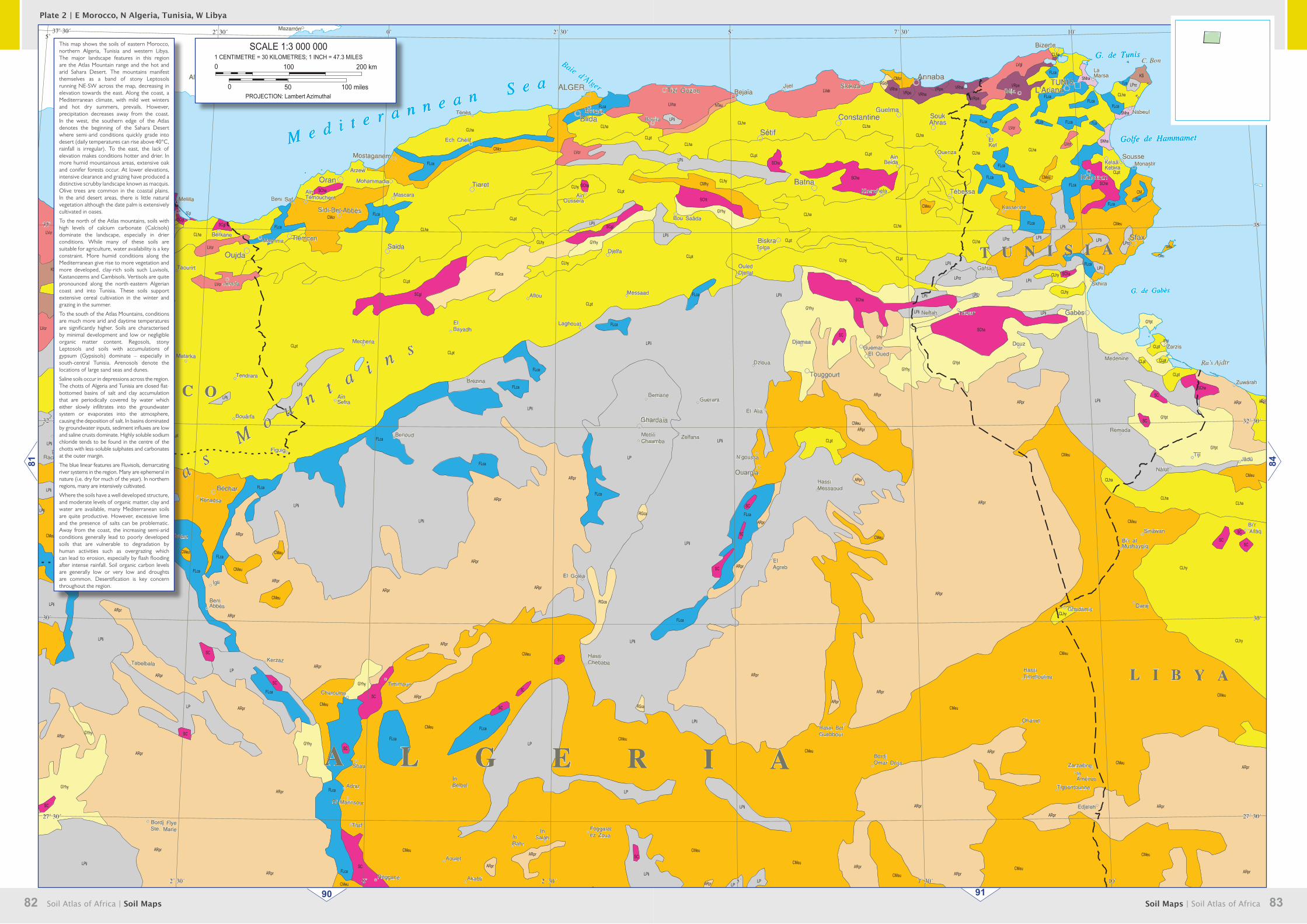
This map shows the soils of eastern Morocco, northern Algeria, Tunisia and western Libya. The major landscape features in this region are the Atlas Mountain range and the hot and arid Sahara Desert. The mountains manifest themselves as a band of stony Leptosols running NE-SW across the map, decreasing in elevation towards the east. Along the coast, a Mediterranean climate, with mild wet winters and hot dry summers, prevails. However, precipitation decreases away from the coast. In the west, the southern edge of the Atlas denotes the beginning of the Sahara Desert where semi-arid conditions quickly grade into desert (daily temperatures can rise above 40°C, rainfall is irregular). To the east, the lack of elevation makes conditions hotter and drier. In more humid mountainous areas, extensive oak and conifer forests occur. At lower elevations, intensive clearance and grazing have produced a distinctive scrubby landscape known as macquis. Olive trees are common in the coastal plains. In the arid desert areas, there is little natural vegetation although the date palm is extensively cultivated in oases.
To the north of the Atlas mountains, soils with high levels of calcium carbonate (Calcisols) dominate the landscape, especially in drier conditions. While many of these soils are suitable for agriculture, water availability is a key constraint. More humid conditions along the Mediterranean give rise to more vegetation and more developed, clay-rich soils such Luvisols, Kastanozems and Cambisols. Vertisols are quite pronounced along the north-eastern Algerian coast and into Tunisia. These soils support extensive cereal cultivation in the winter and grazing in the summer.
To the south of the Atlas Mountains, conditions are much more arid and daytime temperatures are significantly higher. Soils are characterised by minimal development and low or negligible organic matter content. Regosols, stony Leptosols and soils with accumulations of gypsum (Gypsisols) dominate – especially in south-central Tunisia. Arenosols denote the locations of large sand seas and dunes.
Saline soils occur in depressions across the region. The chotts of Algeria and Tunisia are closed flat-bottomed basins of salt and clay accumulation that are periodically covered by water which either slowly infiltrates into the groundwater system or evaporates into the atmosphere, causing the deposition of salt. In basins dominated by groundwater inputs, sediment influxes are low and saline crusts dominate. Highly soluble sodium chloride tends to be found in the centre of the chotts with less-soluble sulphates and carbonates at the outer margin.
The blue linear features are Fluvisols, demarcating river systems in the region. Many are ephemeral in nature (i.e. dry for much of the year). In northern regions, many are intensively cultivated.
Where the soils have a well developed structure, and moderate levels of organic matter, clay and water are available, many Mediterranean soils are quite productive. However, excessive lime and the presence of salts can be problematic. Away from the coast, the increasing semi-arid conditions generally lead to poorly developed soils that are vulnerable to degradation by human activities such as overgrazing which can lead to erosion, especially by flash flooding after intense rainfall. Soil organic carbon levels are generally low or very low and droughts are common. Desertification is key concern throughout the region.
SCALE 1:3 000 0001 CENTIMETRE = 30 KILOMETRES; 1 INCH = 47.3 MILES
PROJECTION: Lambert Azimuthal
0 200 km100
100 miles500
84
90 91
81Plate 2 | E Morocco, N Algeria, Tunisia, W Libya