Embed Size (px)
Citation preview
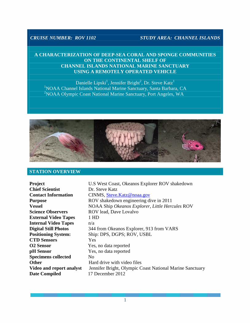
CRUISE NUMBER: ROV 1102 STUDY AREA: CHANNEL ISLANDS
A CHARACTERIZATION OF DEEP-SEA CORAL AND SPONGE COMMUNITIES ON THE CONTINENTAL SHELF OF
CHANNEL ISLANDS NATIONAL MARINE SANCTUARY USING A REMOTELY OPERATED VEHICLE
Danielle Lipski1, Jennifer Bright2, Dr. Steve Katz1
1NOAA Channel Islands National Marine Sanctuary, Santa Barbara, CA 2NOAA Olympic Coast National Marine Sanctuary, Port Angeles, WA
STATION OVERVIEW Project U.S West Coast, Okeanos Explorer ROV shakedown Chief Scientist Dr. Steve Katz Contact Information CINMS, [email protected] Purpose ROV shakedown engineering dive in 2011 Vessel NOAA Ship Okeanos Explorer, Little Hercules ROV Science Observers ROV lead, Dave Lovalvo External Video Tapes 1 HD Internal Video Tapes n/a Digital Still Photos 344 from Okeanos Explorer, 913 from VARS Positioning System: Ship: DPS, DGPS; ROV, USBL CTD Sensors Yes O2 Sensor Yes, no data reported pH Sensor Yes, no data reported Specimens collected No Other Hard drive with video files Video and report analyst Jennifer Bright, Olympic Coast National Marine Sanctuary Date Compiled 17 December 2012
1
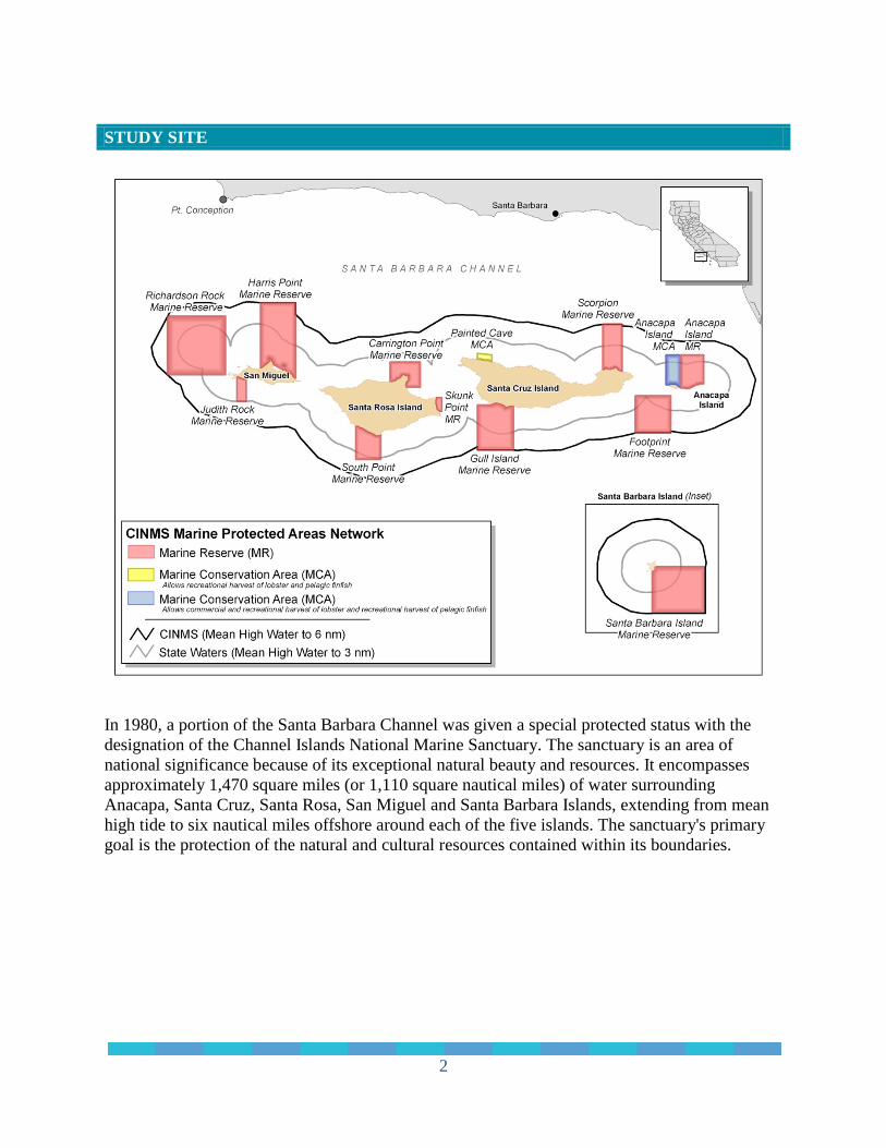
STUDY SITE
In 1980, a portion of the Santa Barbara Channel was given a special protected status with the designation of the Channel Islands National Marine Sanctuary. The sanctuary is an area of national significance because of its exceptional natural beauty and resources. It encompasses approximately 1,470 square miles (or 1,110 square nautical miles) of water surrounding Anacapa, Santa Cruz, Santa Rosa, San Miguel and Santa Barbara Islands, extending from mean high tide to six nautical miles offshore around each of the five islands. The sanctuary's primary goal is the protection of the natural and cultural resources contained within its boundaries.
2
PURPOSE OF FIELD SURVEY The following information was taken from the Okeanos Explorer website oceanexplorer.noaa.gov/okeanos/explorations/ex1101/welcome.html, and written by Meme Lobecker, Expedition Coordinator, Physical Scientist, NOAA Office of Ocean Exploration and Research. California Shakedown Cruise 2011: Exploring California’s National Marine Sanctuaries In 2011, the NOAA Ship Okeanos Explorer began their field season with a shakedown cruise through Channel Islands National Marine Sanctuary. This cruise number EX1101 was focused on preparing for the upcoming field season by performing sonar patch testing. The test cruise in the sanctuary provided an opportunity to test systems and equipment prior to integrating the use of the ROV on board. The cruise also provided an opportunity to conduct bathymetric mapping and to select targets to use for ROV testing for subsequent cruises. Bathymetry files are available at the Okeanos Explorer website listed here: http://oceanexplorer.noaa.gov/okeanos/explorations/ex1101/welcome.html. This cruise also provided an opportunity for the ships scientists to test the performance of scientific equipment and instrumentation. During this cruise, the EM 302 (30 khz) multibeam sonar, EA 600 (12 khz) singlebeam sonar, and Kundsen sub-bottom profiler were tested. After the ship shakedown objectives were met, the cruise took the opportunity to conduct mapping in the vicinity of southern California where the majority of areas mapped were requested by other NOAA offices including Channel Islands National Marine Sanctuary. On board mapping personnel collaborated with scientists from the Office of National Marine Sanctuaries (ONMS) to map areas and collect video imagery within the sanctuary. VESSEL AND ROV DESCRIPTION The Okeanos Explorer is dedicated to exploration around the world, mapping the seafloor and characterizing unknown areas of the ocean. The ship has a multibeam sonar mapping system, conductivity, temperature and depth sensor (CTD), and a remotely operated vehicle (ROV). The images and high-definition video from the ROV can be sent from the vehicle to the ship to the shore in real-time, referred to as “telepresence”. Besides images and video other oceanographic data can be sent to scientists ashore so they can follow the cruise from one of the five Exploration Command Centers (ECC) located in places such as NOAA facilities in Silver Spring, MD and Seattle, WA, and the University of Rhode Island. The Okeanos Explorer is the only NOAA ship to have a dedicated ROV. The ship is also equipped with an integrated control room for operating the multibeam, ROV and telepresence communication equipment.
3
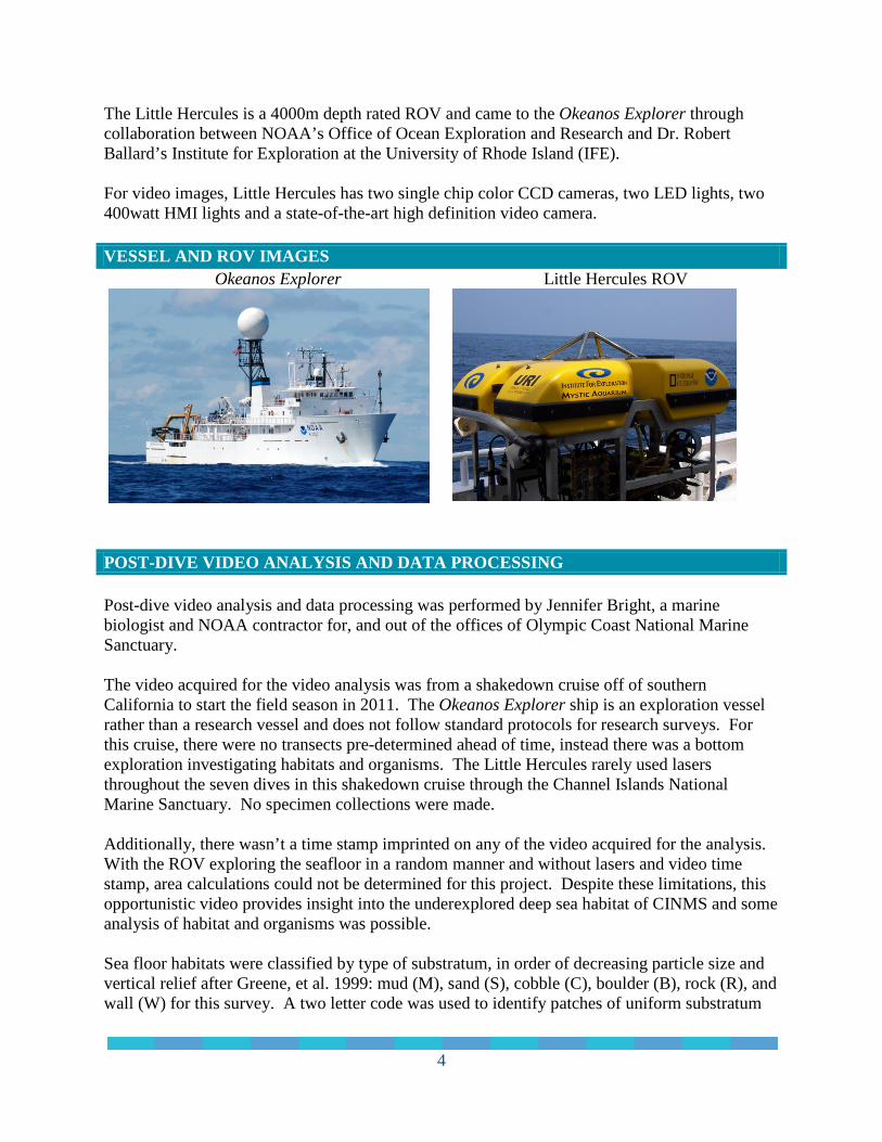
The Little Hercules is a 4000m depth rated ROV and came to the Okeanos Explorer through collaboration between NOAA’s Office of Ocean Exploration and Research and Dr. Robert Ballard’s Institute for Exploration at the University of Rhode Island (IFE). For video images, Little Hercules has two single chip color CCD cameras, two LED lights, two 400watt HMI lights and a state-of-the-art high definition video camera. VESSEL AND ROV IMAGES
Okeanos Explorer Little Hercules ROV
POST-DIVE VIDEO ANALYSIS AND DATA PROCESSING Post-dive video analysis and data processing was performed by Jennifer Bright, a marine biologist and NOAA contractor for, and out of the offices of Olympic Coast National Marine Sanctuary. The video acquired for the video analysis was from a shakedown cruise off of southern California to start the field season in 2011. The Okeanos Explorer ship is an exploration vessel rather than a research vessel and does not follow standard protocols for research surveys. For this cruise, there were no transects pre-determined ahead of time, instead there was a bottom exploration investigating habitats and organisms. The Little Hercules rarely used lasers throughout the seven dives in this shakedown cruise through the Channel Islands National Marine Sanctuary. No specimen collections were made. Additionally, there wasn’t a time stamp imprinted on any of the video acquired for the analysis. With the ROV exploring the seafloor in a random manner and without lasers and video time stamp, area calculations could not be determined for this project. Despite these limitations, this opportunistic video provides insight into the underexplored deep sea habitat of CINMS and some analysis of habitat and organisms was possible. Sea floor habitats were classified by type of substratum, in order of decreasing particle size and vertical relief after Greene, et al. 1999: mud (M), sand (S), cobble (C), boulder (B), rock (R), and wall (W) for this survey. A two letter code was used to identify patches of uniform substratum
4
type. A habitat with a code of BC would designate a boulder cobble habitat with at least 50% of the area observed as boulder and at least 20% of the area as cobble. I also incorporated WC which stands for water column since there were multiple species observed in the water column. Captured video clips were analyzed using Monterey Bay Aquarium Research Institute’s Video Annotation and Reference System (VARS) program to annotate the video clips. The VARS system was then queried and placed into an Excel spreadsheet for further analysis. Additional analysis consisted of determining the approximate size of invertebrates and annotating associations for each dive. Since lasers were not used throughout the video, the video analyst approximated size using previous knowledge of general size categories (small, medium, large) of invertebrates. For example, Swiftia corals range within certain parameters, so a small Swiftia would be visually determined based on the general size of Swiftia. SUMMARY OF PROJECT Project Focused on ship shakedown and sonar patch testing to prepare for
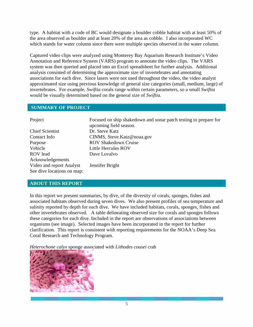
upcoming field season. Chief Scientist Dr. Steve Katz Contact Info CINMS, [email protected] Purpose ROV Shakedown Cruise Vehicle Little Hercules ROV ROV lead Dave Lovalvo Acknowledgements Video and report Analyst Jennifer Bright See dive locations on map: ABOUT THIS REPORT In this report we present summaries, by dive, of the diversity of corals, sponges, fishes and associated habitats observed during seven dives. We also present profiles of sea temperature and salinity reported by depth for each dive. We have included habitats, corals, sponges, fishes and other invertebrates observed. A table delineating observed size for corals and sponges follows these categories for each dive. Included in the report are observations of associations between organisms (see image). Selected images have been incorporated in the report for further clarification. This report is consistent with reporting requirements for the NOAA’s Deep Sea Coral Research and Technology Program. Heterochone calyx sponge associated with Lithodes cousei crab
5
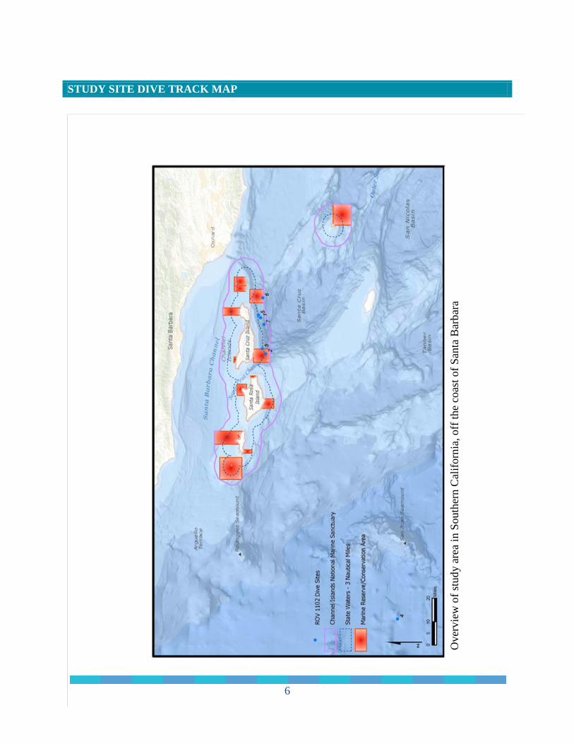
STUDY SITE DIVE TRACK MAP UDY SITE DIVE TRACK MAP
Ove
rvie
w o
f stu
dy a
rea
in S
outh
ern
Cal
iforn
ia, o
ff th
e co
ast o
f San
ta B
arba
ra
6
STUDY SITE DIVE TRAC INVERTEBRATE AND FISH TAXA OBSERVED Invertebrate and fish taxa observed during video analysis from surveys conducted on seven dives with a remotely operated vehicle (ROV) in the Channel Islands National Marine Sanctuary. The total number of species observed during seven dives were 271 corals, 264 sponges, 261 fish and a 3,322 other invertebrates for a total of 4,118 observed species. Observed species are listed below: Scientific Name Common Name Taxon Anthomastus ritteri Mushroom coral Coral Clavularia sp. Soft coral Coral Halipteris californica Sea pen Coral Paragorgia sp. White with red polyps Coral Pennatula phosphorea Phosphorescent sea pen Coral Pennatulacea Unidentified sea pen Coral Plexuridae Swiftia like Coral Umbelllula lindahli Droopsy sea pen Coral Virgularia sp. Sea pen Coral Farrea occa Lace (cloud) foliose sponge Sponge Heterochone calyx Fingered goblet Sponge Hexaxtinella sp. Sponge (white) Sponge Porifera Unidentified barrel sponges Sponge Porifera Unidentified globular sponges Sponge Porifera Unidentified vase sponges Sponge Porifera Unidentified columnar sponges Sponge Porifera Unidentified multi-tube sponges Sponge Porifera Unidentified shelf sponges Sponge Porifera Unidentified encrusting sponges Sponge Porifera Unidentified lobate sponges Sponge Porifera Unidentified stalked-funnel sponges Sponge Actiniaria Unidentified anemones Anemone Cerianthidae Unidentified tube anemones Anemone Corallimorphidae Unidentified white tip anemone Anemone Liponema brevicornis Pom pom anemone Anemone Sabellidae (red) Feather duster worm Annelid Sabellidae Feather duster worm Annelid Serpulidae Tube worm Annelid Brisingida Sea star Asteroid Ceramaster sp. Cushion sea star Asteroid Gephyreaster sp. Sea star Asteroid Henricia sp. Sea star Asteroid Poraniopsis inflata spiny sea star Asteroid Solaster sp. Sea star Asteroid
7

Zoroaster sp. Sea star Asteroid Scientific Name Common Name Taxon Asteronyx sp. Brittle star Brittle star Ophiuroidea Brittle star Brittle star Octopus sp. Octopus Cephalopod Chionoecetes sp. Crab Crab Chorillia sp. Decorator crab Crab Lithodidae Crab Crab Munida sp. Squat lobster Crab Florometra serratissima Sea lily Crinoid Pannychia moseleyi Sea cucumber Cucumber Psolus sp. Sea cucumber Cucumber Calliostoma sp. Top snail Gastropod Neptunea sp. Whelk Gastropod Caprellidae Skeleton shrimp Amphipod Benthocodon sp. jelly (dark red) jelly Poralia rufescens jelly (dark red) jelly Tritoniidae Nudibranch (white) Nudibranch Pectinidae Scallop Mollusk Pandalopsis sp. Shrimp Shrimp Dromalia alexandri Siphonophore Siphonophore Cnemidocarpa sp. Pink sea squirt Tunicate Corynascicia sp. Tunicate (clear) Tunicate Megalodicpoia sp. Predatory tunicate Tunicate Strongylocentrotus fragilis Fragile urchin Urchin Agonidae Unidentified poachers Fish Apristurus brunneus Catsharks Fish Cottidae Unidentified sculpins Fish Embassichthys bathybius Deepsea sole Fish Eptatretus stoutii Pacific hagfish Fish Lycenchelys crotalinus Snakehead eelpout Fish Lycodapus spp. Unidentified eelpouts Fish Microstomus pacificus Dover sole Fish Osteichthyes Unidentified fishes Fish Raja rhina Longnose skate Fish Scyliorhinidae Unidentified catsharks Fish Scorpaenidae Unidentified scorpion fishes Fish Sebastolobus sp. Unidentified thorneyheads Fish Zoarcidae Unidentified eelpouts Fish
8
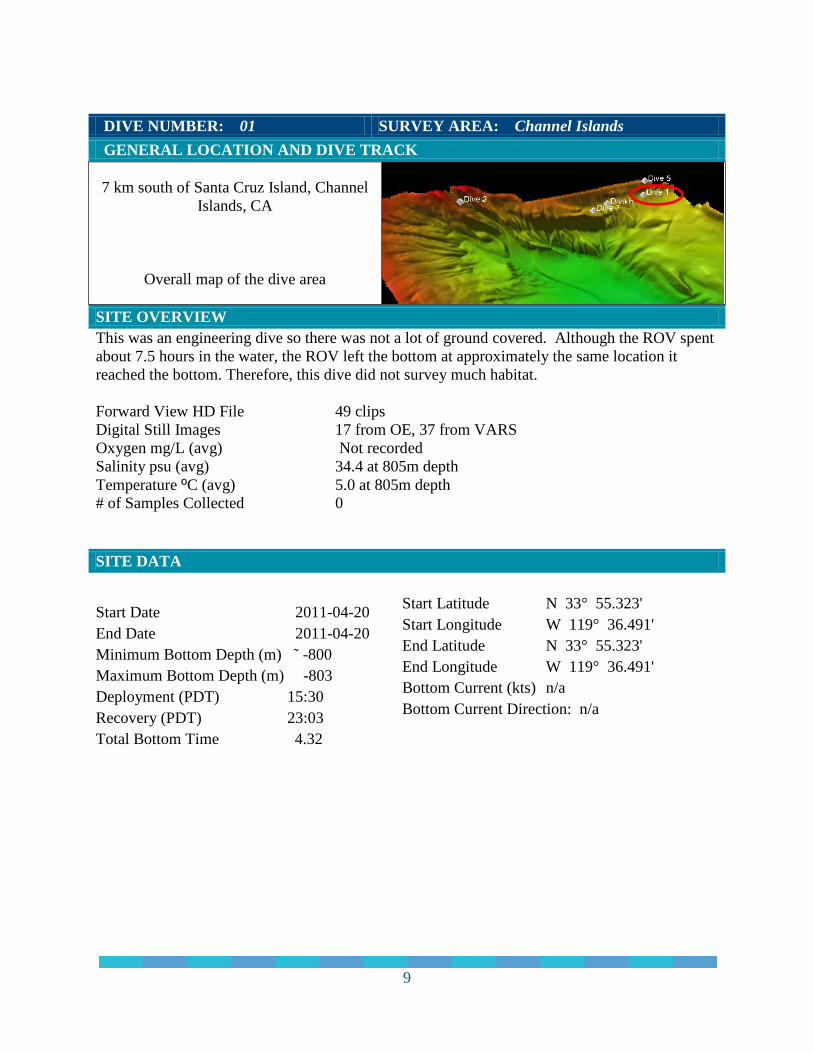
DIVE NUMBER: 01 SURVEY AREA: Channel Islands GENERAL LOCATION AND DIVE TRACK
7 km south of Santa Cruz Island, Channel Islands, CA
Overall map of the dive area
SITE OVERVIEW This was an engineering dive so there was not a lot of ground covered. Although the ROV spent about 7.5 hours in the water, the ROV left the bottom at approximately the same location it reached the bottom. Therefore, this dive did not survey much habitat. Forward View HD File 49 clips Digital Still Images 17 from OE, 37 from VARS Oxygen mg/L (avg) Not recorded Salinity psu (avg) 34.4 at 805m depth Temperature ºC (avg) 5.0 at 805m depth # of Samples Collected 0 SITE DATA
Start Date 2011-04-20 End Date 2011-04-20 Minimum Bottom Depth (m) ˜ -800 Maximum Bottom Depth (m) -803 Deployment (PDT) 15:30 Recovery (PDT) 23:03 Total Bottom Time 4.32
Start Latitude N 33° 55.323' Start Longitude W 119° 36.491' End Latitude N 33° 55.323' End Longitude W 119° 36.491' Bottom Current (kts) n/a Bottom Current Direction: n/a
9
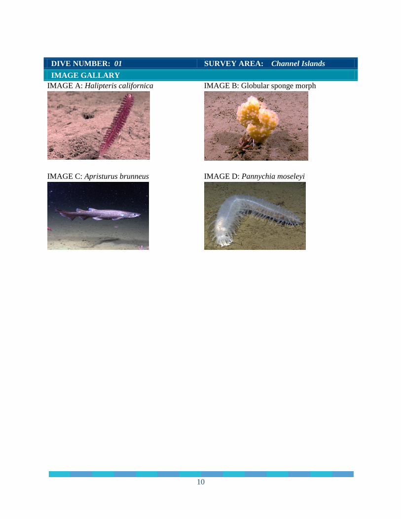
DIVE NUMBER: 01 SURVEY AREA: Channel Islands IMAGE GALLARY IMAGE A: Halipteris californica IMAGE B: Globular sponge morph
IMAGE C: Apristurus brunneus
IMAGE D: Pannychia moseleyi
10
DIVE NUMBER: 01 SURVEY AREA: Channel Islands PHYSICAL ENVIRONMENT
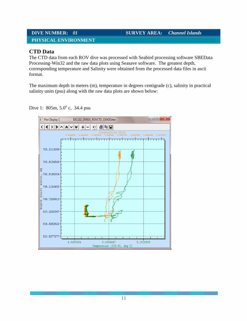
CTD Data The CTD data from each ROV dive was processed with Seabird processing software SBEData Processing-Win32 and the raw data plots using Seasave software. The greatest depth, corresponding temperature and Salinity were obtained from the processed data files in ascii format. The maximum depth in meters (m), temperature in degrees centigrade (c), salinity in practical salinity units (psu) along with the raw data plots are shown below: Dive 1: 805m, 5.0o c, 34.4 psu
11
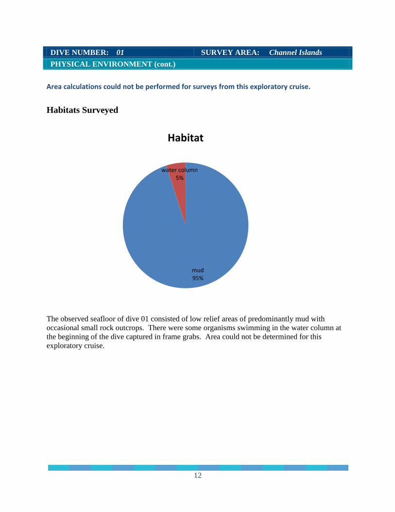
DIVE NUMBER: 01 SURVEY AREA: Channel Islands PHYSICAL ENVIRONMENT (cont.) Area calculations could not be performed for surveys from this exploratory cruise. Habitats Surveyed
The observed seafloor of dive 01 consisted of low relief areas of predominantly mud with occasional small rock outcrops. There were some organisms swimming in the water column at the beginning of the dive captured in frame grabs. Area could not be determined for this exploratory cruise.
mud 95%
water column 5%
Habitat
12
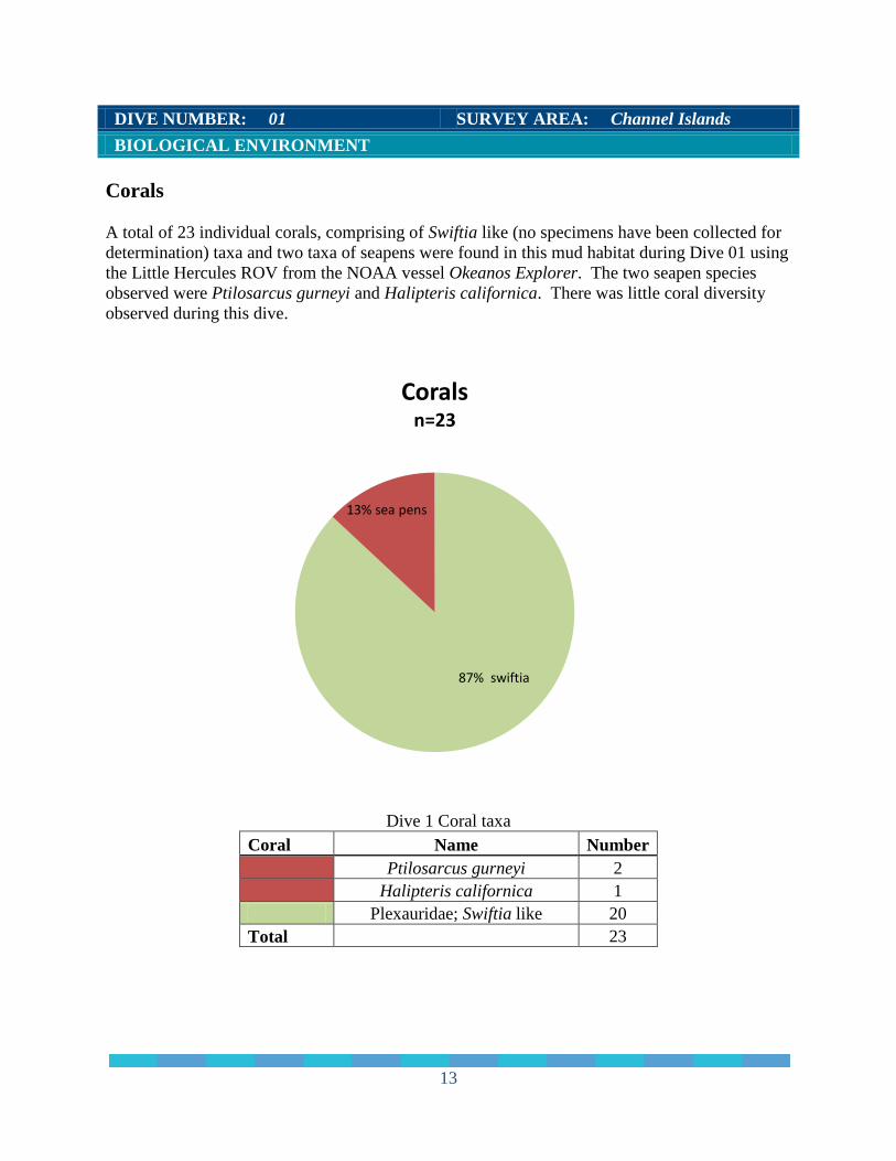
DIVE NUMBER: 01 SURVEY AREA: Channel Islands BIOLOGICAL ENVIRONMENT Corals A total of 23 individual corals, comprising of Swiftia like (no specimens have been collected for determination) taxa and two taxa of seapens were found in this mud habitat during Dive 01 using the Little Hercules ROV from the NOAA vessel Okeanos Explorer. The two seapen species observed were Ptilosarcus gurneyi and Halipteris californica. There was little coral diversity observed during this dive.
Dive 1 Coral taxa Coral Name Number
Ptilosarcus gurneyi 2
Halipteris californica 1
Plexauridae; Swiftia like 20 Total
23
87% swiftia
13% sea pens
Corals n=23
13
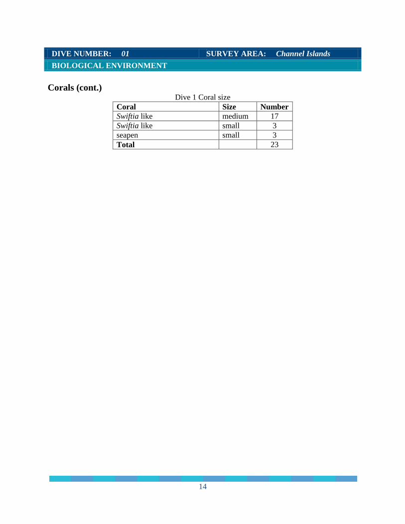
DIVE NUMBER: 01 SURVEY AREA: Channel Islands BIOLOGICAL ENVIRONMENT Corals (cont.)
Dive 1 Coral size Coral Size Number Swiftia like medium 17 Swiftia like small 3 seapen small 3 Total 23
14
DIVE NUMBER: 01 SURVEY AREA: Channel Islands BIOLOGICAL ENVIRONMENT
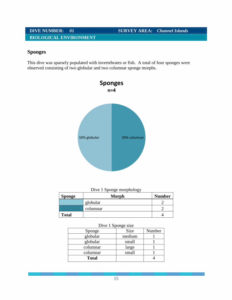
Sponges This dive was sparsely populated with invertebrates or fish. A total of four sponges were observed consisting of two globular and two columnar sponge morphs.
Dive 1 Sponge morphology Sponge Morph Number
globular 2
columnar 2 Total
4
Dive 1 Sponge size
Sponge Size Number globular medium 1 globular small 1 columnar large 1 columnar small 1
Total 4
50% columnar 50% globular
Sponges n=4
15
DIVE NUMBER: 01 SURVEY AREA: Channel Islands BIOLOGICAL ENVIRONMENT
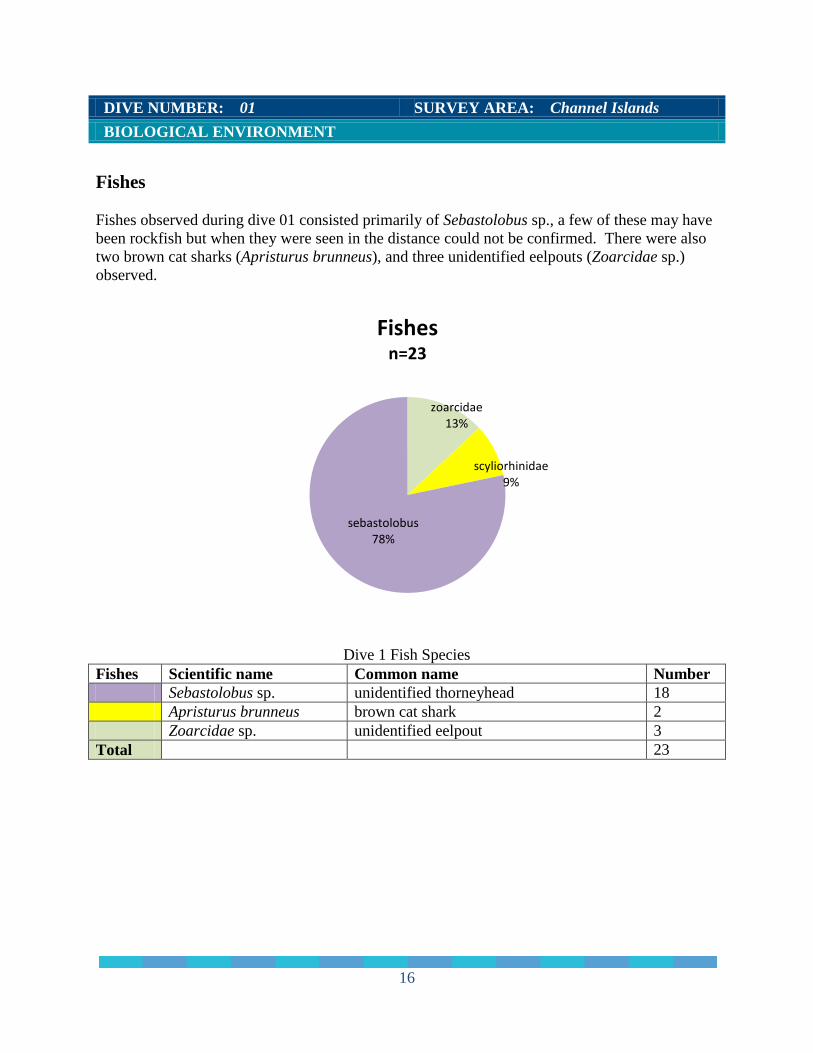
Fishes Fishes observed during dive 01 consisted primarily of Sebastolobus sp., a few of these may have been rockfish but when they were seen in the distance could not be confirmed. There were also two brown cat sharks (Apristurus brunneus), and three unidentified eelpouts (Zoarcidae sp.) observed.
Dive 1 Fish Species Fishes Scientific name Common name Number Sebastolobus sp. unidentified thorneyhead 18 Apristurus brunneus brown cat shark 2 Zoarcidae sp. unidentified eelpout 3 Total 23
zoarcidae 13%
scyliorhinidae 9%
sebastolobus 78%
Fishes n=23
16
Species Associations There were only three associations observed during dive 01. Assoc. # Association Associated with # of assoc. 1 globular sponge decorator crab 1 2 Swiftia like brittle star 3 3 Swiftia like brittle star 1 ADDITIONAL COMMENTS This was the first dive of this leg and site selection was limited by spatial closures of the Pacific Missile Testing Range that overlaps the intended survey areas. Within the accessible area, this site was chosen to provide even low relief terrain, and it was. The bottom was dominated by low relief, low gradient soft sediment with occasional small rock outcrops. The smooth sediment was populated with common soft bottom animals – sea cucumbers (numerous Pannychia moseleyi and occasional Psolus sp.), sparsely distributed ground fish (thorneyheads and other rockfish), small decorator crabs (Brachiuran crabs) and whelks. Rock outcrops were small (˂10m in longest dimension), and were commonly anchors for deep water sponge species. It was also interesting to see a brown cat shark in the first hour of the dive – most of what we know of them is from trawl by-catch and those specimens are not in good condition.
17
DIVE NUMBER: 02 SURVEY AREA: Channel Islands GENERAL LOCATION AND DIVE TRACK
Santa Cruz Canyon
SITE OVERVIEW This dive was aborted at 50m depth to recover vehicles and resolve software issues. Forward View HD File: 10 clips Digital Still Images 3 from OE Oxygen mg/L (avg) Not recorded Salinity psu (avg) 34.0 at 85m depth Temperature ºC (avg) 9.1 at 85m depth # of Samples Collected 0 SITE DATA Start Date 2011-04-21 End Date 2011-04-21 Minimum Bottom Depth (m) none reported Maximum Bottom Depth (m) none reported Deployment (PDT) 20:34 Recovery (PDT) 21:40
Start Latitude none reported Start Longitude none reported End Latitude none reported End Longitude none reported Bottom Current (kts) n/a Bottom Current Direction: n/a
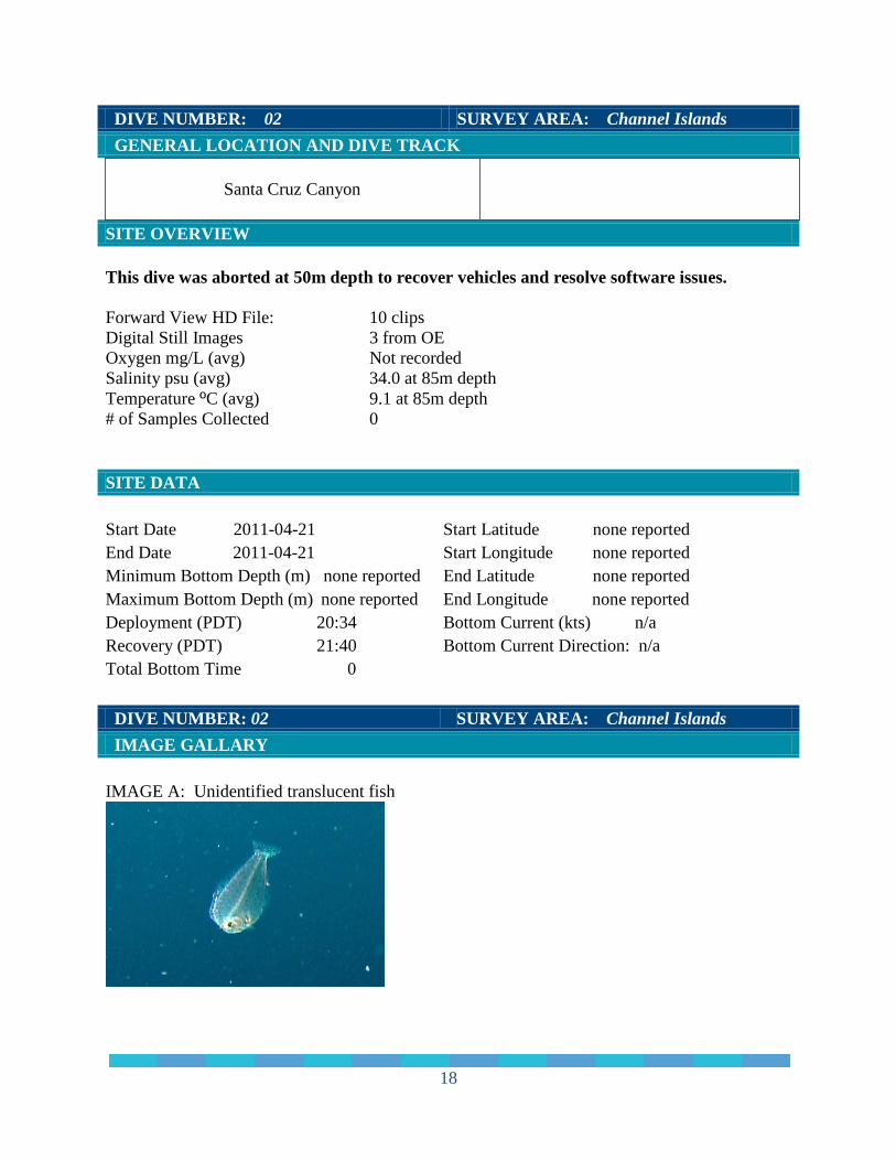
Total Bottom Time 0 DIVE NUMBER: 02 SURVEY AREA: Channel Islands IMAGE GALLARY IMAGE A: Unidentified translucent fish
18
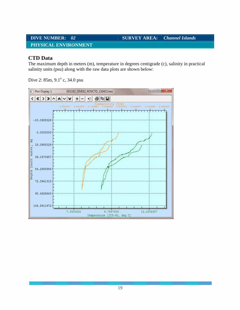
DIVE NUMBER: 02 SURVEY AREA: Channel Islands PHYSICAL ENVIRONMENT CTD Data The maximum depth in meters (m), temperature in degrees centigrade (c), salinity in practical salinity units (psu) along with the raw data plots are shown below: Dive 2: 85m, 9.1o c, 34.0 psu
19
DIVE NUMBER: 02 SURVEY AREA: Channel Islands PHYSICAL ENVIRONMENT Habitats Surveyed This was an aborted dive and a brief view of the bottom revealed mud habitat. DIVE NUMBER: 02 SURVEY AREA: Channel Islands BIOLOGICAL ENVIRONMENT Corals No corals were observed during this aborted dive.
DIVE NUMBER: 02 SURVEY AREA: Channel Islands BIOLOGICAL ENVIRONMENT
Sponges No sponges were observed during this aborted dive. DIVE NUMBER: 02 SURVEY AREA: Channel Islands BIOLOGICAL ENVIRONMENT
Fishes One Sebastolobus sp. and one unknown translucent fish were observed during this aborted dive. ADDITIONAL COMMENTS There were a few invertebrates observed prior to the aborted 50m depth dive. See table below.
Dive 2 all species
Invertebrate Number Strongylocentrotus fragilis 3 Pannychia moseleyi 2 Gastropoda 3 Actiniaria 2 Total 10
20
DIVE NUMBER: 03 SURVEY AREA: Channel Islands GENERAL LOCATION AND DIVE TRACK
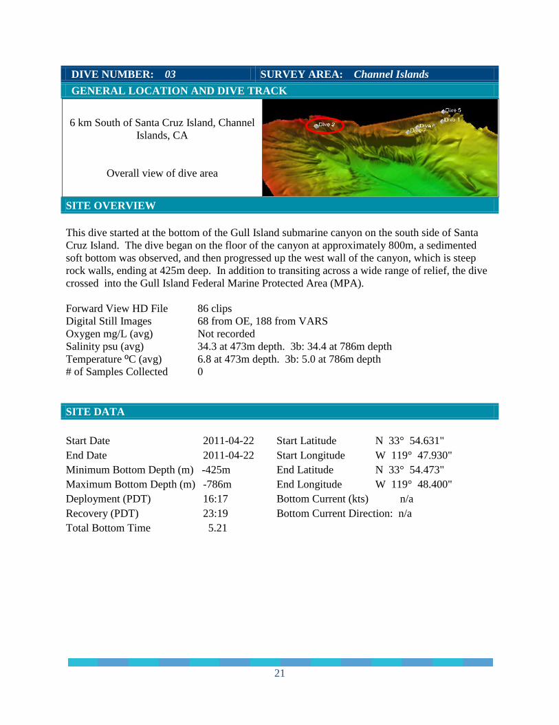
6 km South of Santa Cruz Island, Channel Islands, CA
Overall view of dive area
SITE OVERVIEW This dive started at the bottom of the Gull Island submarine canyon on the south side of Santa Cruz Island. The dive began on the floor of the canyon at approximately 800m, a sedimented soft bottom was observed, and then progressed up the west wall of the canyon, which is steep rock walls, ending at 425m deep. In addition to transiting across a wide range of relief, the dive crossed into the Gull Island Federal Marine Protected Area (MPA). Forward View HD File 86 clips Digital Still Images 68 from OE, 188 from VARS Oxygen mg/L (avg) Not recorded Salinity psu (avg) 34.3 at 473m depth. 3b: 34.4 at 786m depth Temperature ºC (avg) 6.8 at 473m depth. 3b: 5.0 at 786m depth # of Samples Collected 0 SITE DATA Start Date 2011-04-22 End Date 2011-04-22 Minimum Bottom Depth (m) -425m Maximum Bottom Depth (m) -786m Deployment (PDT) 16:17 Recovery (PDT) 23:19
Start Latitude N 33° 54.631" Start Longitude W 119° 47.930" End Latitude N 33° 54.473" End Longitude W 119° 48.400" Bottom Current (kts) n/a Bottom Current Direction: n/a
Total Bottom Time 5.21
21
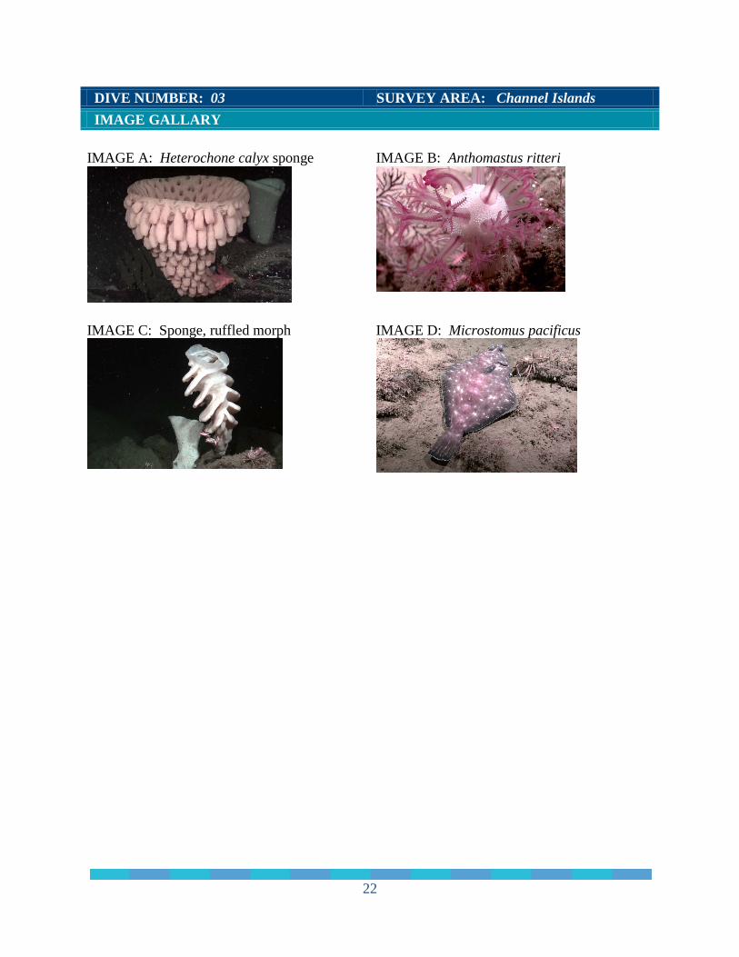
DIVE NUMBER: 03 SURVEY AREA: Channel Islands IMAGE GALLARY IMAGE A: Heterochone calyx sponge
IMAGE B: Anthomastus ritteri
IMAGE C: Sponge, ruffled morph
IMAGE D: Microstomus pacificus
22
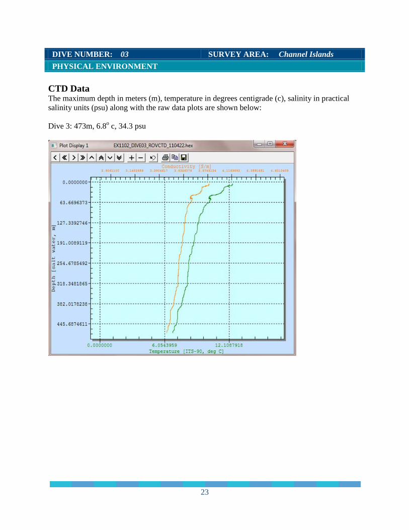
DIVE NUMBER: 03 SURVEY AREA: Channel Islands PHYSICAL ENVIRONMENT CTD Data The maximum depth in meters (m), temperature in degrees centigrade (c), salinity in practical salinity units (psu) along with the raw data plots are shown below: Dive 3: 473m, 6.8o c, 34.3 psu
23
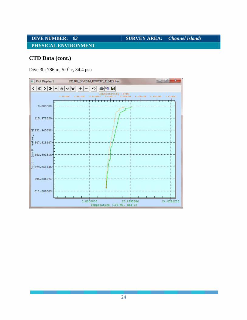
DIVE NUMBER: 03 SURVEY AREA: Channel Islands PHYSICAL ENVIRONMENT CTD Data (cont.) Dive 3b: 786 m, 5.0o c, 34.4 psu
24
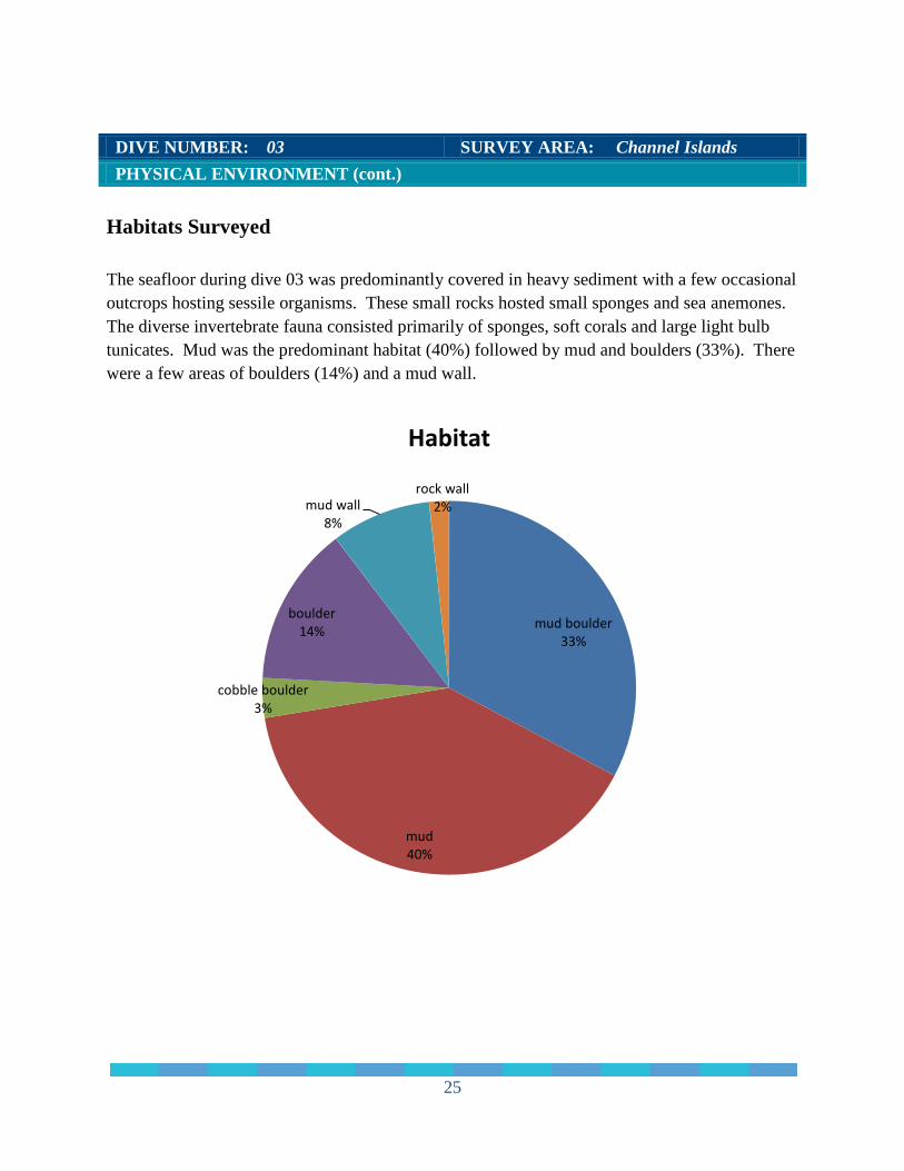
DIVE NUMBER: 03 SURVEY AREA: Channel Islands PHYSICAL ENVIRONMENT (cont.) Habitats Surveyed The seafloor during dive 03 was predominantly covered in heavy sediment with a few occasional outcrops hosting sessile organisms. These small rocks hosted small sponges and sea anemones. The diverse invertebrate fauna consisted primarily of sponges, soft corals and large light bulb tunicates. Mud was the predominant habitat (40%) followed by mud and boulders (33%). There were a few areas of boulders (14%) and a mud wall.
mud boulder 33%
mud 40%
cobble boulder 3%
boulder 14%
mud wall 8%
rock wall 2%
Habitat
25
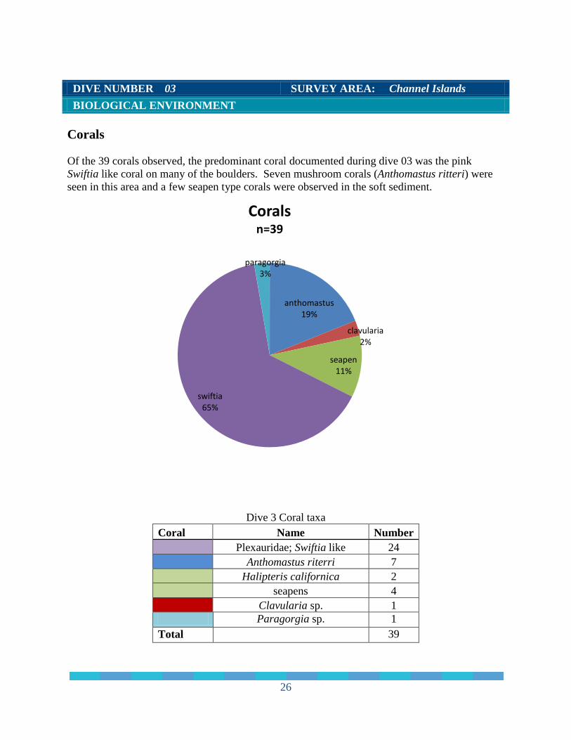
DIVE NUMBER 03 SURVEY AREA: Channel Islands BIOLOGICAL ENVIRONMENT Corals Of the 39 corals observed, the predominant coral documented during dive 03 was the pink Swiftia like coral on many of the boulders. Seven mushroom corals (Anthomastus ritteri) were seen in this area and a few seapen type corals were observed in the soft sediment.
Dive 3 Coral taxa
Coral Name Number
Plexauridae; Swiftia like 24
Anthomastus riterri 7
Halipteris californica 2
seapens 4
Clavularia sp. 1
Paragorgia sp. 1 Total 39
anthomastus 19%
clavularia 2%
seapen 11%
swiftia 65%
paragorgia 3%
Corals n=39
26
DIVE NUMBER 03 SURVEY AREA: Channel Islands BIOLOGICAL ENVIRONMENT Corals (Cont.)
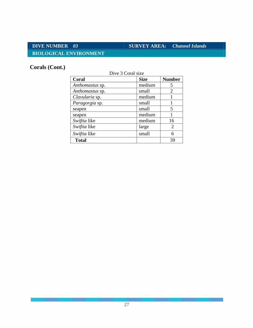
Dive 3 Coral size Coral Size Number Anthomastus sp. medium 5 Anthomastus sp. small 2 Clavularia sp. medium 1 Paragorgia sp. small 1 seapen small 5 seapen medium 1 Swiftia like medium 16 Swiftia like large 2 Swiftia like small 6 Total 39
27
DIVE NUMBER: 03 SURVEY AREA: Channel Islands BIOLOGICAL ENVIRONMENT
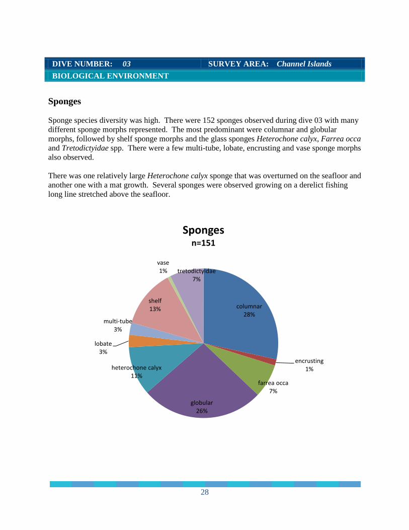
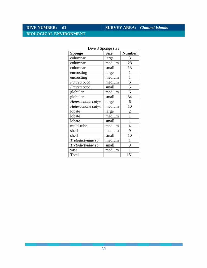
Sponges Sponge species diversity was high. There were 152 sponges observed during dive 03 with many different sponge morphs represented. The most predominant were columnar and globular morphs, followed by shelf sponge morphs and the glass sponges Heterochone calyx, Farrea occa and Tretodictyidae spp. There were a few multi-tube, lobate, encrusting and vase sponge morphs also observed. There was one relatively large Heterochone calyx sponge that was overturned on the seafloor and another one with a mat growth. Several sponges were observed growing on a derelict fishing long line stretched above the seafloor.
columnar 28%
encrusting 1%
farrea occa 7%
globular 26%
heterochone calyx 11%
lobate 3%
multi-tube 3%
shelf 13%
vase 1% tretodictyidae
7%
Sponges n=151
28
DIVE NUMBER: 03 SURVEY AREA: Channel Islands BIOLOGICAL ENVIRONMENT Sponges (cont.)
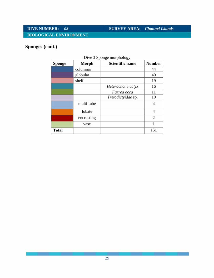
Dive 3 Sponge morphology Sponge Morph Scientific name Number
columnar
44
globular
40
shelf
19
Heterochone calyx 16
Farrea occa 11
Tretodictyidae sp. 10 multi-tube 4
lobate 4 encrusting 2 vase 1 Total 151
29
DIVE NUMBER: 03 SURVEY AREA: Channel Islands BIOLOGICAL ENVIRONMENT
Dive 3 Sponge size Sponge Size Number columnar large 3 columnar medium 28 columnar small 13 encrusting large 1 encrusting medium 1 Farrea occa medium 6 Farrea occa small 5 globular medium 6 globular small 34 Heterochone calyx large 6 Heterochone calyx medium 10 lobate large 2 lobate medium 1 lobate small 1 multi-tube medium 4 shelf medium 9 shelf small 10 Tretodictyidae sp. medium 1 Tretodictyidae sp. small 9 vase medium 1 Total 151
30
DIVE NUMBER: 03 SURVEY AREA: Channel Islands BIOLOGICAL ENVIRONMENT
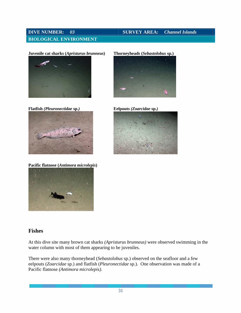
Juvenile cat sharks (Apristurus brunneus) Thorneyheads (Sebastolobus sp.)
Flatfish (Pleuronectidae sp.) Eelpouts (Zoarcidae sp.)
Pacific flatnose (Antimora microlepis)
Fishes At this dive site many brown cat sharks (Apristurus brunneus) were observed swimming in the water column with most of them appearing to be juveniles. There were also many thorneyhead (Sebastolobus sp.) observed on the seafloor and a few eelpouts (Zoarcidae sp.) and flatfish (Pleuronectidae sp.). One observation was made of a Pacific flatnose (Antimora microlepis).
31
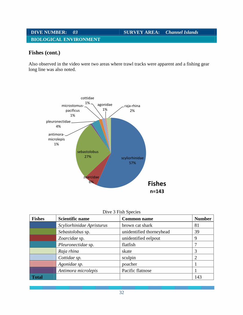
DIVE NUMBER: 03 SURVEY AREA: Channel Islands BIOLOGICAL ENVIRONMENT Fishes (cont.) Also observed in the video were two areas where trawl tracks were apparent and a fishing gear long line was also noted.
Dive 3 Fish Species Fishes Scientific name Common name Number
Scyliorhinidae Apristurus brown cat shark 81
Sebastolobus sp. unidentified thorneyhead 39
Zoarcidae sp. unidentified eelpout 9
Pleuronectidae sp. flatfish 7
Raja rhina skate 3 Cottidae sp. sculpin 2 Agonidae sp. poacher 1 Antimora microlepis Pacific flatnose 1 Total 143
scyliorhinidae 57%
zoarcidae 6%
sebastolobus 27%
antimora-microlepis
1%
pleuronectidae 4%
microstomus-pacificus
1%
cottidae 1% agonidae
1% raja-rhina
2%
Fishes n=143
32
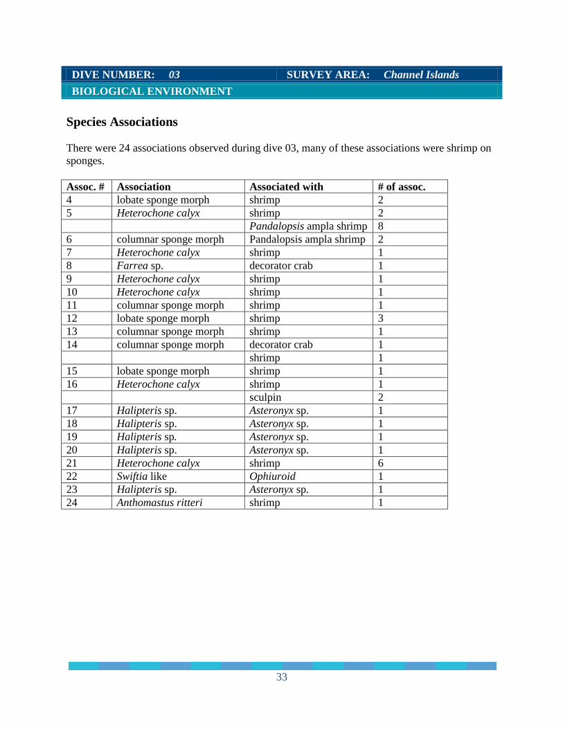
DIVE NUMBER: 03 SURVEY AREA: Channel Islands BIOLOGICAL ENVIRONMENT Species Associations There were 24 associations observed during dive 03, many of these associations were shrimp on sponges. Assoc. # Association Associated with # of assoc. 4 lobate sponge morph shrimp 2 5 Heterochone calyx shrimp 2 Pandalopsis ampla shrimp 8 6 columnar sponge morph Pandalopsis ampla shrimp 2 7 Heterochone calyx shrimp 1 8 Farrea sp. decorator crab 1 9 Heterochone calyx shrimp 1 10 Heterochone calyx shrimp 1 11 columnar sponge morph shrimp 1 12 lobate sponge morph shrimp 3 13 columnar sponge morph shrimp 1 14 columnar sponge morph decorator crab 1 shrimp 1 15 lobate sponge morph shrimp 1 16 Heterochone calyx shrimp 1 sculpin 2 17 Halipteris sp. Asteronyx sp. 1 18 Halipteris sp. Asteronyx sp. 1 19 Halipteris sp. Asteronyx sp. 1 20 Halipteris sp. Asteronyx sp. 1 21 Heterochone calyx shrimp 6 22 Swiftia like Ophiuroid 1 23 Halipteris sp. Asteronyx sp. 1 24 Anthomastus ritteri shrimp 1
33
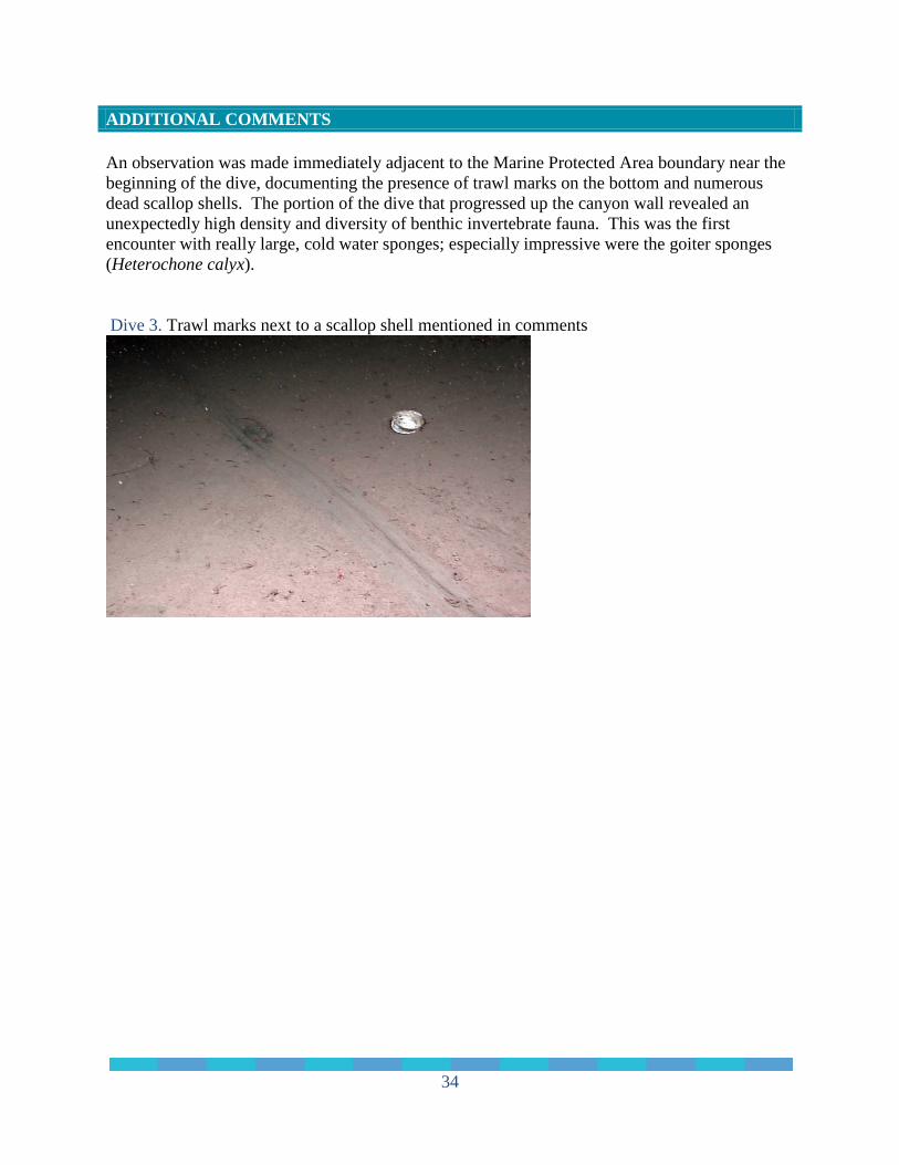
ADDITIONAL COMMENTS An observation was made immediately adjacent to the Marine Protected Area boundary near the beginning of the dive, documenting the presence of trawl marks on the bottom and numerous dead scallop shells. The portion of the dive that progressed up the canyon wall revealed an unexpectedly high density and diversity of benthic invertebrate fauna. This was the first encounter with really large, cold water sponges; especially impressive were the goiter sponges (Heterochone calyx). Dive 3. Trawl marks next to a scallop shell mentioned in comments
34
DIVE NUMBER: 04 SURVEY AREA: Channel Islands GENERAL LOCATION AND DIVE TRACK
170 km west of San Nicolas, Channel Islands, CA This dive was outside of Channel Islands National
Marine Sanctuary
Cupcake Deep
SITE OVERVIEW The dive was aborted. ROV port vertical thrusters stopped operating during descent. Forward View HD File 11 clips Digital Still Images 3 from OE Oxygen mg/L (avg) Not recorded Salinity psu (avg) 34.7 at 4007m depth Temperature ºC (avg) 1.5 at 4007m depth # of Samples Collected 0 SITE DATA Start Date 2011-04-23 End Date 2011-04-24 Minimum Bottom Depth (m) -3,988m Maximum Bottom Depth (m) -3,988m Deployment (PDT) 16:17 Recovery (PDT) 00:42
Start Latitude N 33° 04.735" Start Longitude W 121° 27.989" End Latitude N 33° 04.735" End Longitude W 121° 27.989" Bottom Current (kts) Bottom Current Direction:
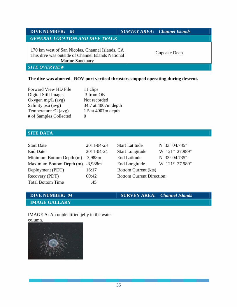
Total Bottom Time .45 DIVE NUMBER: 04 SURVEY AREA: Channel Islands IMAGE GALLARY IMAGE A: An unidentified jelly in the water column.
35

DIVE NUMBER: 04 SURVEY AREA: Channel Islands PHYSICAL ENVIRONMENT CTD Data The maximum depth in meters (m), temperature in degrees centigrade (c), salinity in practical salinity units (psu) along with the raw data plots are shown below: Dive 4: 4007m, 1.5o c, 34.7 psu
36
DIVE NUMBER: 04 SURVEY AREA: Channel Islands PHYSICAL ENVIRONMENT (cont.) Habitats The dive was aborted
DIVE NUMBER: 04 SURVEY AREA: Channel Islands BIOLOGICAL ENVIRONMENT Corals The dive was aborted. DIVE NUMBER: 04 SURVEY AREA: Channel Islands BIOLOGICAL ENVIRONMENT
Sponges The dive was aborted. DIVE NUMBER: 04 SURVEY AREA: Channel Islands BIOLOGICAL ENVIRONMENT
Fishes The dive was aborted. ADDITIONAL COMMENTS The dive was aborted due to problems with the ROV.
37
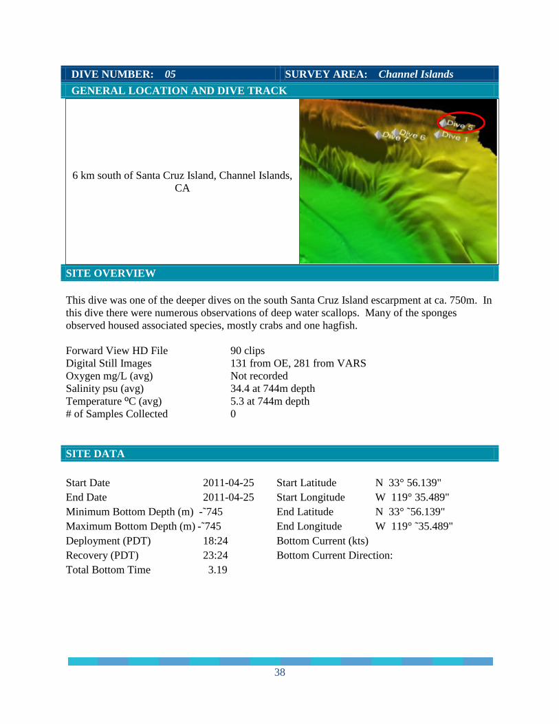
DIVE NUMBER: 05 SURVEY AREA: Channel Islands GENERAL LOCATION AND DIVE TRACK
6 km south of Santa Cruz Island, Channel Islands, CA
SITE OVERVIEW This dive was one of the deeper dives on the south Santa Cruz Island escarpment at ca. 750m. In this dive there were numerous observations of deep water scallops. Many of the sponges observed housed associated species, mostly crabs and one hagfish. Forward View HD File 90 clips Digital Still Images 131 from OE, 281 from VARS Oxygen mg/L (avg) Not recorded Salinity psu (avg) 34.4 at 744m depth Temperature ºC (avg) 5.3 at 744m depth # of Samples Collected 0 SITE DATA Start Date 2011-04-25 End Date 2011-04-25 Minimum Bottom Depth (m) -˜745 Maximum Bottom Depth (m) -˜745 Deployment (PDT) 18:24 Recovery (PDT) 23:24 Total Bottom Time 3.19
Start Latitude N 33° 56.139" Start Longitude W 119° 35.489" End Latitude N 33° ˜56.139" End Longitude W 119° ˜35.489" Bottom Current (kts) Bottom Current Direction:
38
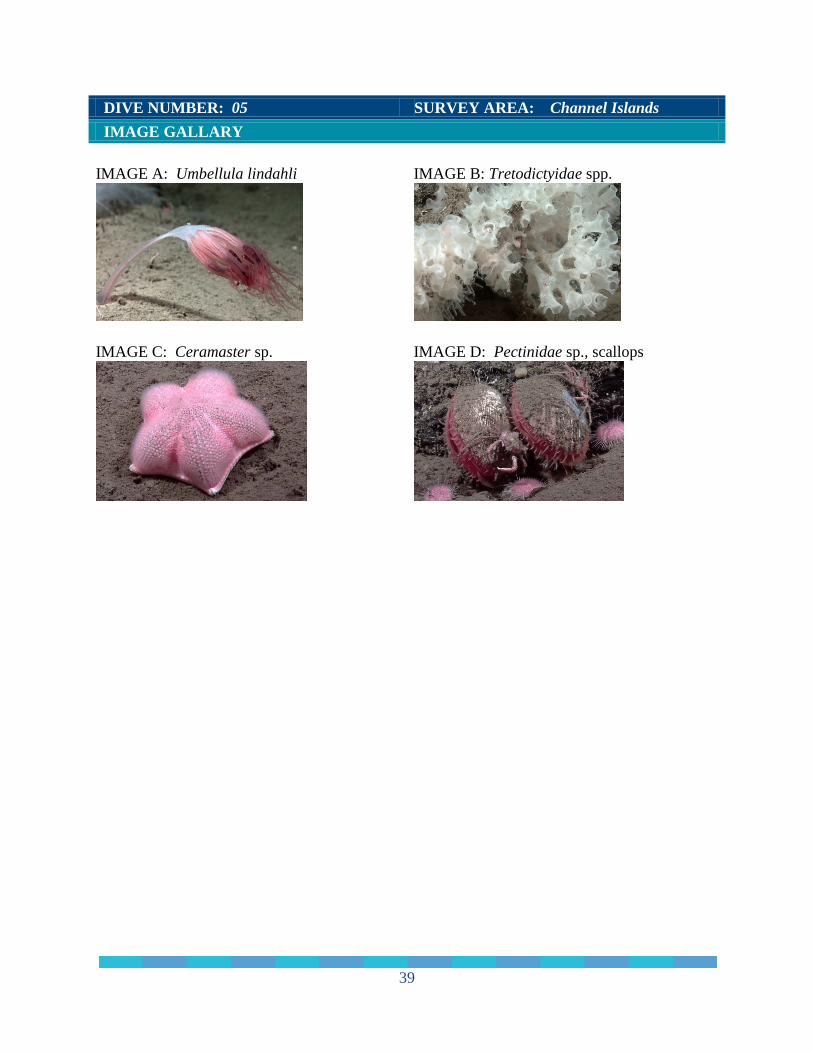
DIVE NUMBER: 05 SURVEY AREA: Channel Islands IMAGE GALLARY IMAGE A: Umbellula lindahli
IMAGE B: Tretodictyidae spp.
IMAGE C: Ceramaster sp.
IMAGE D: Pectinidae sp., scallops
39
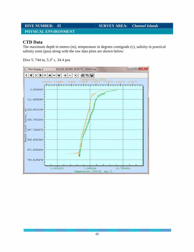
DIVE NUMBER: 05 SURVEY AREA: Channel Islands PHYSICAL ENVIRONMENT CTD Data The maximum depth in meters (m), temperature in degrees centigrade (c), salinity in practical salinity units (psu) along with the raw data plots are shown below: Dive 5: 744 m, 5.3o c, 34.4 psu
40
DIVE NUMBER: 05 SURVEY AREA: Channel Islands PHYSICAL ENVIRONMENT (cont.)
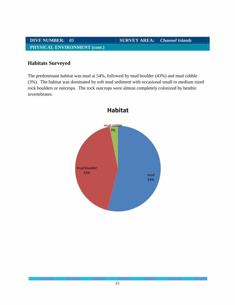
Habitats Surveyed The predominant habitat was mud at 54%, followed by mud boulder (43%) and mud cobble (3%). The habitat was dominated by soft mud sediment with occasional small to medium sized rock boulders or outcrops. The rock outcrops were almost completely colonized by benthic invertebrates.
mud 54%
mud boulder 43%
mud cobble 3%
Habitat
41
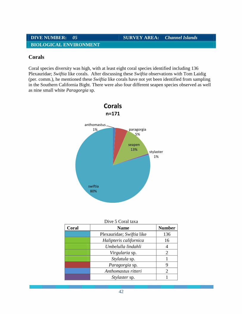
DIVE NUMBER: 05 SURVEY AREA: Channel Islands BIOLOGICAL ENVIRONMENT Corals Coral species diversity was high, with at least eight coral species identified including 136 Plexauridae; Swiftia like corals. After discussing these Swiftia observations with Tom Laidig (per. comm.), he mentioned these Swiftia like corals have not yet been identified from sampling in the Southern California Bight. There were also four different seapen species observed as well as nine small white Paragorgia sp.
Dive 5 Coral taxa Coral Name Number
Plexauridae; Swiftia like 136
Halipteris californica 16
Umbelulla lindahli 4 Virgularia sp. 2 Stylatula sp. 1
Paragorgia sp. 9
Anthomastus ritteri 2
Stylaster sp. 1
anthomastus 1% paragorgia
5%
seapen 13% stylaster
1%
swiftia 80%
Corals n=171
42
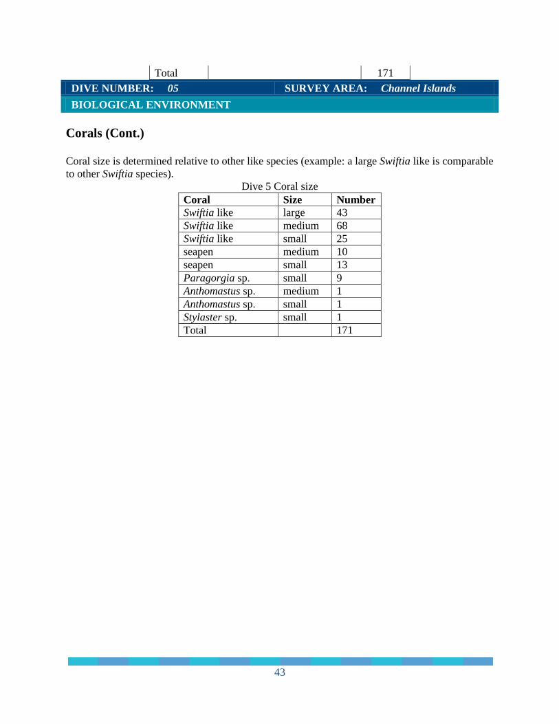
Total
171 DIVE NUMBER: 05 SURVEY AREA: Channel Islands BIOLOGICAL ENVIRONMENT Corals (Cont.) Coral size is determined relative to other like species (example: a large Swiftia like is comparable to other Swiftia species).
Dive 5 Coral size Coral Size Number Swiftia like large 43 Swiftia like medium 68 Swiftia like small 25 seapen medium 10 seapen small 13 Paragorgia sp. small 9 Anthomastus sp. medium 1 Anthomastus sp. small 1 Stylaster sp. small 1 Total 171
43
DIVE NUMBER: 05 SURVEY AREA: Channel Islands BIOLOGICAL ENVIRONMENT
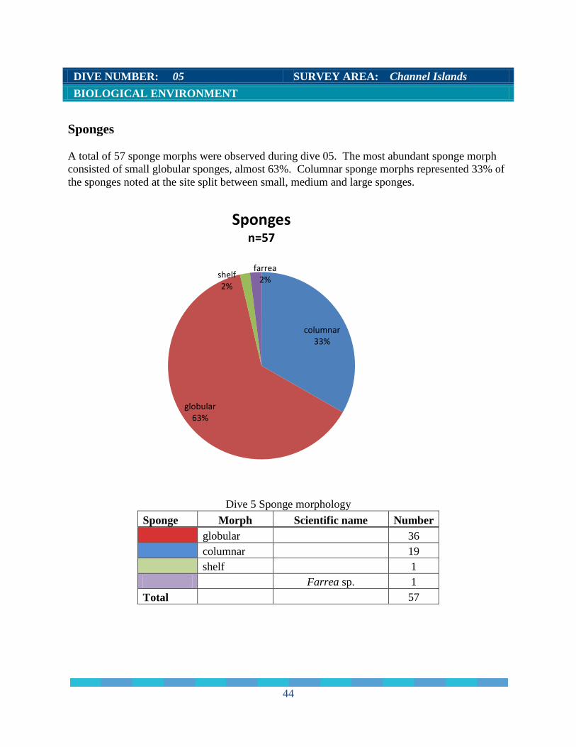
Sponges A total of 57 sponge morphs were observed during dive 05. The most abundant sponge morph consisted of small globular sponges, almost 63%. Columnar sponge morphs represented 33% of the sponges noted at the site split between small, medium and large sponges.
Dive 5 Sponge morphology Sponge Morph Scientific name Number
globular
36
columnar
19
shelf
1
Farrea sp. 1 Total
57
columnar 33%
globular 63%
shelf 2%
farrea 2%
Sponges n=57
44

DIVE NUMBER: 05 SURVEY AREA: Channel Islands BIOLOGICAL ENVIRONMENT Sponges (Cont.)
Dive 5 Sponge size
Sponge Size Number globular medium 5 globular small 31 columnar large 5 columnar medium 9 columnar small 5 shelf medium 1 Farrea sp. medium 1 Total 57
45
DIVE NUMBER: 05 SURVEY AREA: Channel Islands BIOLOGICAL ENVIRONMENT
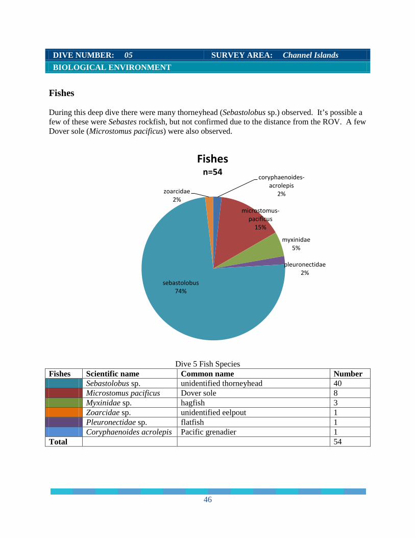
Fishes During this deep dive there were many thorneyhead (Sebastolobus sp.) observed. It’s possible a few of these were Sebastes rockfish, but not confirmed due to the distance from the ROV. A few Dover sole (Microstomus pacificus) were also observed.
Dive 5 Fish Species
Fishes Scientific name Common name Number Sebastolobus sp. unidentified thorneyhead 40 Microstomus pacificus Dover sole 8 Myxinidae sp. hagfish 3 Zoarcidae sp. unidentified eelpout 1 Pleuronectidae sp. flatfish 1 Coryphaenoides acrolepis Pacific grenadier 1 Total 54
coryphaenoides-acrolepis
2%
microstomus-pacificus
15%
myxinidae 5%
pleuronectidae 2%
sebastolobus 74%
zoarcidae 2%
Fishes n=54
46
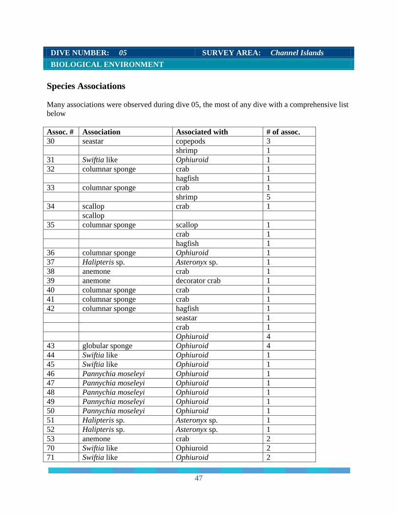
DIVE NUMBER: 05 SURVEY AREA: Channel Islands BIOLOGICAL ENVIRONMENT Species Associations Many associations were observed during dive 05, the most of any dive with a comprehensive list below Assoc. # Association Associated with # of assoc. 30 seastar copepods 3 shrimp 1 31 Swiftia like Ophiuroid 1 32 columnar sponge crab 1 hagfish 1 33 columnar sponge crab 1 shrimp 5 34 scallop crab 1 scallop 35 columnar sponge scallop 1 crab 1 hagfish 1 36 columnar sponge Ophiuroid 1 37 Halipteris sp. Asteronyx sp. 1 38 anemone crab 1 39 anemone decorator crab 1 40 columnar sponge crab 1 41 columnar sponge crab 1 42 columnar sponge hagfish 1 seastar 1 crab 1 Ophiuroid 4 43 globular sponge Ophiuroid 4 44 Swiftia like Ophiuroid 1 45 Swiftia like Ophiuroid 1 46 Pannychia moseleyi Ophiuroid 1 47 Pannychia moseleyi Ophiuroid 1 48 Pannychia moseleyi Ophiuroid 1 49 Pannychia moseleyi Ophiuroid 1 50 Pannychia moseleyi Ophiuroid 1 51 Halipteris sp. Asteronyx sp. 1 52 Halipteris sp. Asteronyx sp. 1 53 anemone crab 2 70 Swiftia like Ophiuroid 2 71 Swiftia like Ophiuroid 2
47

DIVE NUMBER: 05 SURVEY AREA: Channel Islands BIOLOGICAL ENVIRONMENT Species Associations (cont.) Assoc. # Association Associated with # of assoc. 72 Swiftia like Ophiuroid 1 73 Swiftia like Ophiuroid 2 74 Swiftia like Ophiuroid 1 76 Swiftia like Ophiuroid 4 77 Paragorgia sp. Ophiuroid 1 78 Swiftia like Ophiuroid 2 79 Swiftia like Ophiuroid 4 80 columnar sponge squat lobster 1 81 Swiftia like crab 1 82 Halipteris sp. Asteronyx sp. 1 83 Halipteris sp. Asteronyx sp. 1 84 Halipteris sp. Asteronyx sp. 1 85 Halipteris sp. Asteronyx sp. 1 86 columnar sponge brittle star 1
48
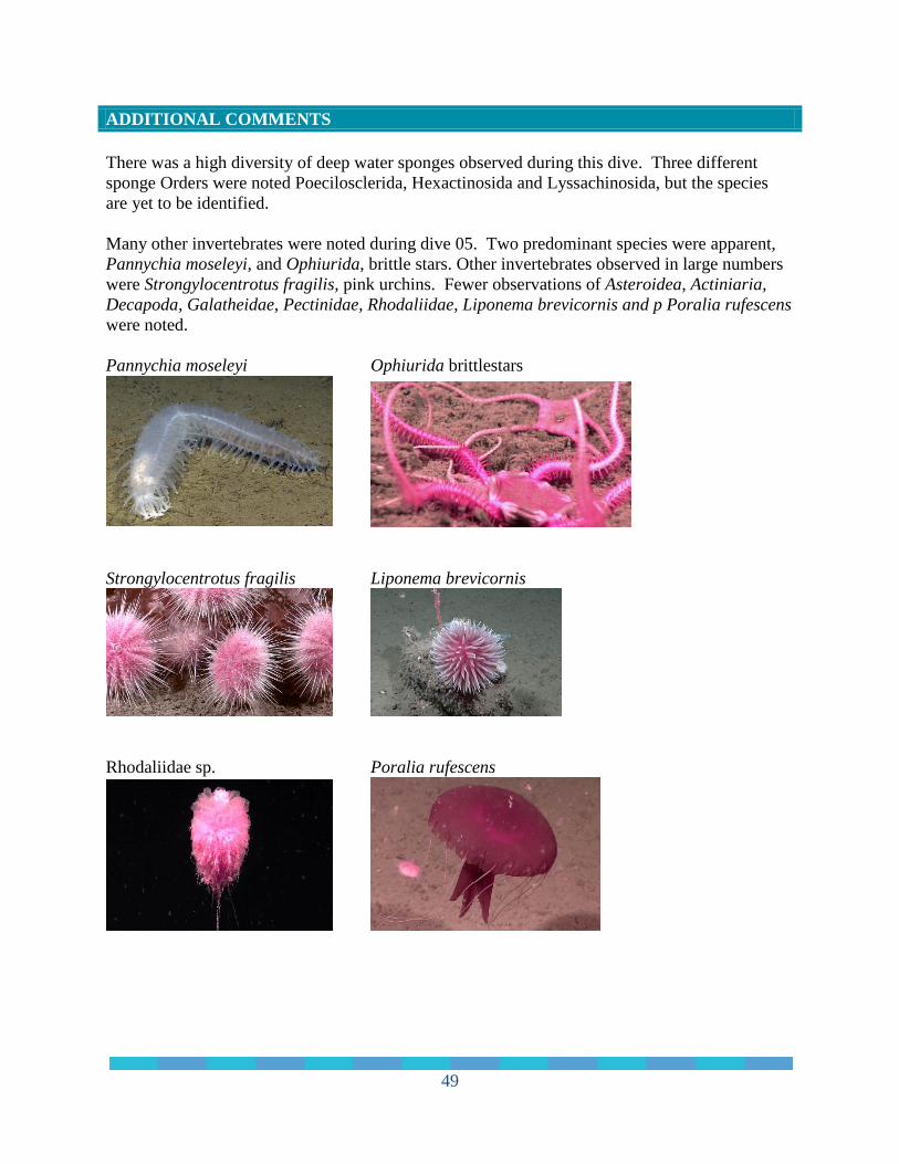
ADDITIONAL COMMENTS There was a high diversity of deep water sponges observed during this dive. Three different sponge Orders were noted Poecilosclerida, Hexactinosida and Lyssachinosida, but the species are yet to be identified. Many other invertebrates were noted during dive 05. Two predominant species were apparent, Pannychia moseleyi, and Ophiurida, brittle stars. Other invertebrates observed in large numbers were Strongylocentrotus fragilis, pink urchins. Fewer observations of Asteroidea, Actiniaria, Decapoda, Galatheidae, Pectinidae, Rhodaliidae, Liponema brevicornis and p Poralia rufescens were noted. Pannychia moseleyi Ophiurida brittlestars
Strongylocentrotus fragilis Liponema brevicornis
Rhodaliidae sp. Poralia rufescens
49
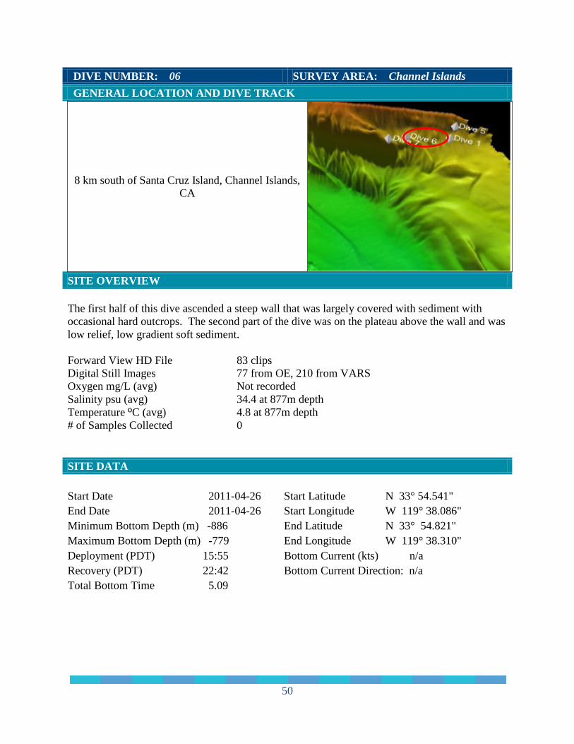
DIVE NUMBER: 06 SURVEY AREA: Channel Islands GENERAL LOCATION AND DIVE TRACK
8 km south of Santa Cruz Island, Channel Islands, CA
SITE OVERVIEW The first half of this dive ascended a steep wall that was largely covered with sediment with occasional hard outcrops. The second part of the dive was on the plateau above the wall and was low relief, low gradient soft sediment. Forward View HD File 83 clips Digital Still Images 77 from OE, 210 from VARS Oxygen mg/L (avg) Not recorded Salinity psu (avg) 34.4 at 877m depth Temperature ºC (avg) 4.8 at 877m depth # of Samples Collected 0 SITE DATA Start Date 2011-04-26 End Date 2011-04-26 Minimum Bottom Depth (m) -886 Maximum Bottom Depth (m) -779 Deployment (PDT) 15:55 Recovery (PDT) 22:42
Start Latitude N 33° 54.541" Start Longitude W 119° 38.086" End Latitude N 33° 54.821" End Longitude W 119° 38.310" Bottom Current (kts) n/a Bottom Current Direction: n/a
Total Bottom Time 5.09
50
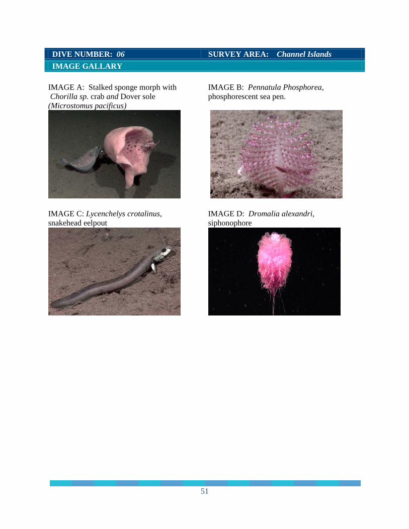
DIVE NUMBER: 06 SURVEY AREA: Channel Islands IMAGE GALLARY IMAGE A: Stalked sponge morph with Chorilla sp. crab and Dover sole (Microstomus pacificus)
IMAGE B: Pennatula Phosphorea, phosphorescent sea pen.
IMAGE C: Lycenchelys crotalinus, snakehead eelpout
IMAGE D: Dromalia alexandri, siphonophore
51
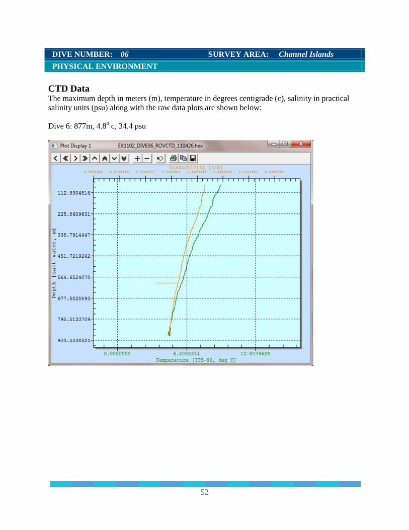
DIVE NUMBER: 06 SURVEY AREA: Channel Islands PHYSICAL ENVIRONMENT CTD Data The maximum depth in meters (m), temperature in degrees centigrade (c), salinity in practical salinity units (psu) along with the raw data plots are shown below: Dive 6: 877m, 4.8o c, 34.4 psu
52
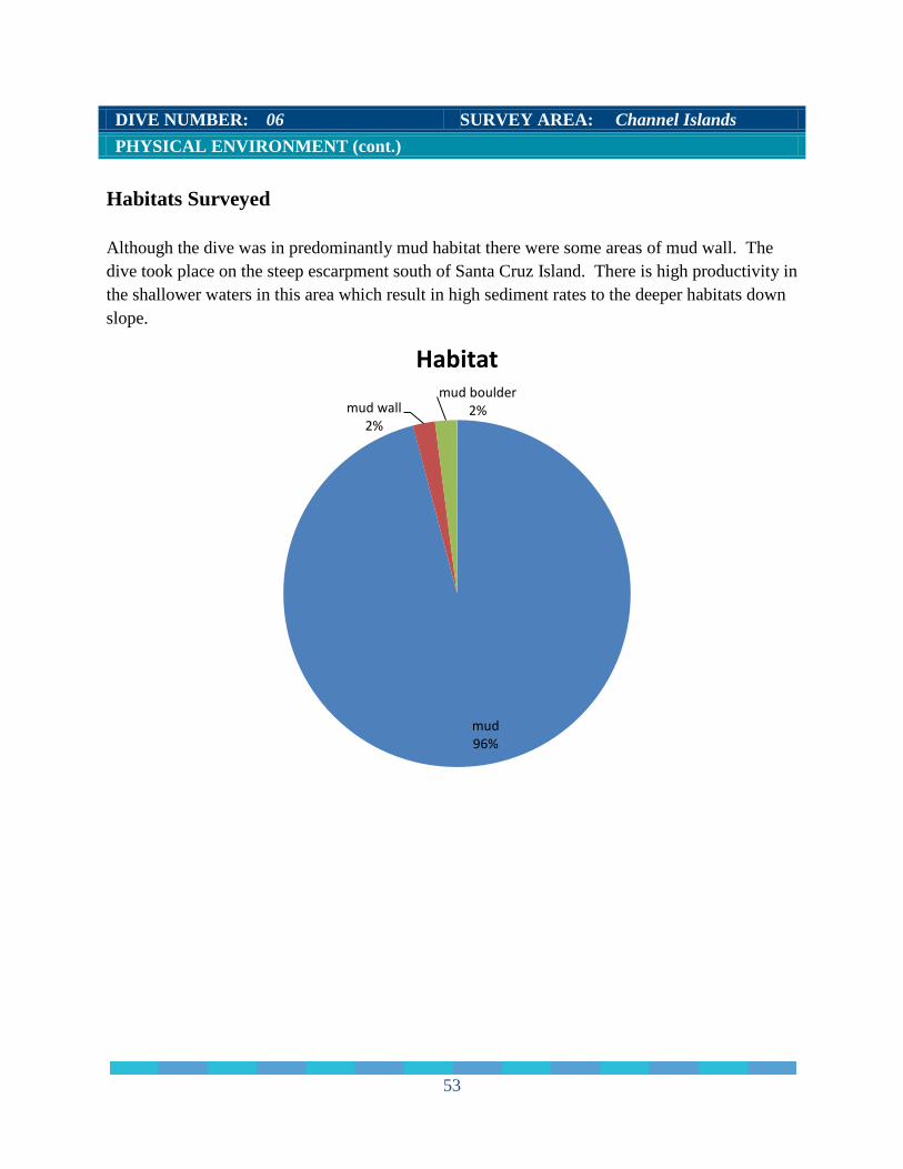
DIVE NUMBER: 06 SURVEY AREA: Channel Islands PHYSICAL ENVIRONMENT (cont.) Habitats Surveyed Although the dive was in predominantly mud habitat there were some areas of mud wall. The dive took place on the steep escarpment south of Santa Cruz Island. There is high productivity in the shallower waters in this area which result in high sediment rates to the deeper habitats down slope.
mud 96%
mud wall 2%
mud boulder 2%
Habitat
53
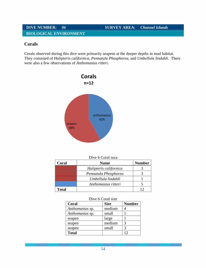
DIVE NUMBER: 06 SURVEY AREA: Channel Islands BIOLOGICAL ENVIRONMENT Corals Corals observed during this dive were primarily seapens at the deeper depths in mud habitat. They consisted of Halipteris californica, Pennatula Phosphorea, and Umbellula lindahli. There were also a few observations of Anthomastus ritteri.
Dive 6 Coral taxa Coral Name Number
Halipteris californica 3
Pennatula Phosphorea 3
Umbellula lindahli 1
Anthomastus ritteri 5
Total
12
Dive 6 Coral size Coral Size Number Anthomastus sp. medium 4 Anthomastus sp. small 1 seapen large 1 seapen medium 3 seapen small 3 Total 12
anthomastus 42%
seapen 58%
Corals n=12
54

DIVE NUMBER: 06 SURVEY AREA: Channel Islands BIOLOGICAL ENVIRONMENT
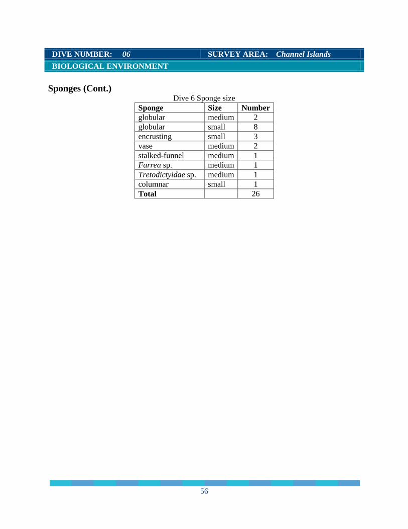
Sponges Most of the sponges observed in dive 06 were globular and columnar sponge morphs. There were also a few encrusting and vase sponge morphs noted. Two glass sponge species were observed in this area, both the Ferrea sp. and Tretodictyidae spp. were noted. There was a mat growth observed on one of the vase sponges in this area.
Dive 6 Sponge morpholoogy Sponge Morph Scientific name Number
globular
10
encrusting
3
vase
2
stalked-funnel
1
Farrea sp. 1 Tretodictyidae sp. 1 columnar 8 Total
26
columnar 31%
encrusting 11%
farrea 4%
globular 38%
stalked-funnel 4%
tretodictyidae 4%
vase 8%
Sponges n=26
55
DIVE NUMBER: 06 SURVEY AREA: Channel Islands BIOLOGICAL ENVIRONMENT Sponges (Cont.)
Dive 6 Sponge size Sponge Size Number globular medium 2 globular small 8 encrusting small 3 vase medium 2 stalked-funnel medium 1 Farrea sp. medium 1 Tretodictyidae sp. medium 1 columnar small 1 Total 26
56
DIVE NUMBER: 06 SURVEY AREA: Channel Islands BIOLOGICAL ENVIRONMENT
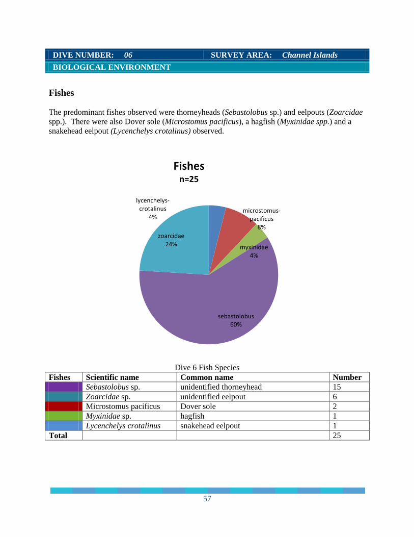
Fishes The predominant fishes observed were thorneyheads (Sebastolobus sp.) and eelpouts (Zoarcidae spp.). There were also Dover sole (Microstomus pacificus), a hagfish (Myxinidae spp.) and a snakehead eelpout (Lycenchelys crotalinus) observed.
Dive 6 Fish Species
Fishes Scientific name Common name Number Sebastolobus sp. unidentified thorneyhead 15 Zoarcidae sp. unidentified eelpout 6 Microstomus pacificus Dover sole 2 Myxinidae sp. hagfish 1 Lycenchelys crotalinus snakehead eelpout 1 Total 25
lycenchelys-crotalinus
4% microstomus-
pacificus 8%
myxinidae 4%
sebastolobus 60%
zoarcidae 24%
Fishes n=25
57
DIVE NUMBER: 06 SURVEY AREA: Channel Islands BIOLOGICAL ENVIRONMENT Species Associations There were six species associations observed during dive 06 and are listed below. Assoc. # Association Associated with # of assoc. 54 columnar sponge sea star 1 shrimp 1 55 Farrea sp. Ophiuroid 12 56 columnar sponge Ophiuroid 1 57 stalked funnel sponge king crab 1 58 vase sponge sea star 1 crab 1 59 columnar sponge crab 4 ADDITIONAL COMMENTS The steep wall in dive 06 was heavily sedimented and indicates lamina of historic sedimentation. The sponges observed on the wall were attached to the hard bottom just beneath the thin sediment layer.
58

DIVE NUMBER: 07 SURVEY AREA: Channel Islands GENERAL LOCATION AND DIVE TRACK
9 km south of Santa Cruz Island, Channel Islands, CA
SITE OVERVIEW Dive 07 was the last dive of the leg. The dive occurred on a moderate gradient slope on the escarpment south of Santa Cruz Island. The entire dive was deep for this area at approximately 900-1000m deep. Forward View HD File 64 clips Digital Still Images 45 from OE, 197 from VARS Oxygen mg/L (avg) Not recorded Salinity psu (avg) 34.4 at 1007m depth Temperature ºC (avg) 4.4 at 1007m depth # of Samples Collected 0 SITE DATA Start Date 2011-04-27 End Date 2011-04-27 Minimum Bottom Depth (m) -910 Maximum Bottom Depth (m) -1,014 Deployment (PDT) 14:48 Recovery (GMT) 20:40
Start Latitude N 33° 54.026" Start Longitude W 119° 38.954" End Latitude N 33°54.137" End Longitude W 119° 38.967" Bottom Current (kts) n/a Bottom Current Direction: n/a
Total Bottom Time 3.46
59
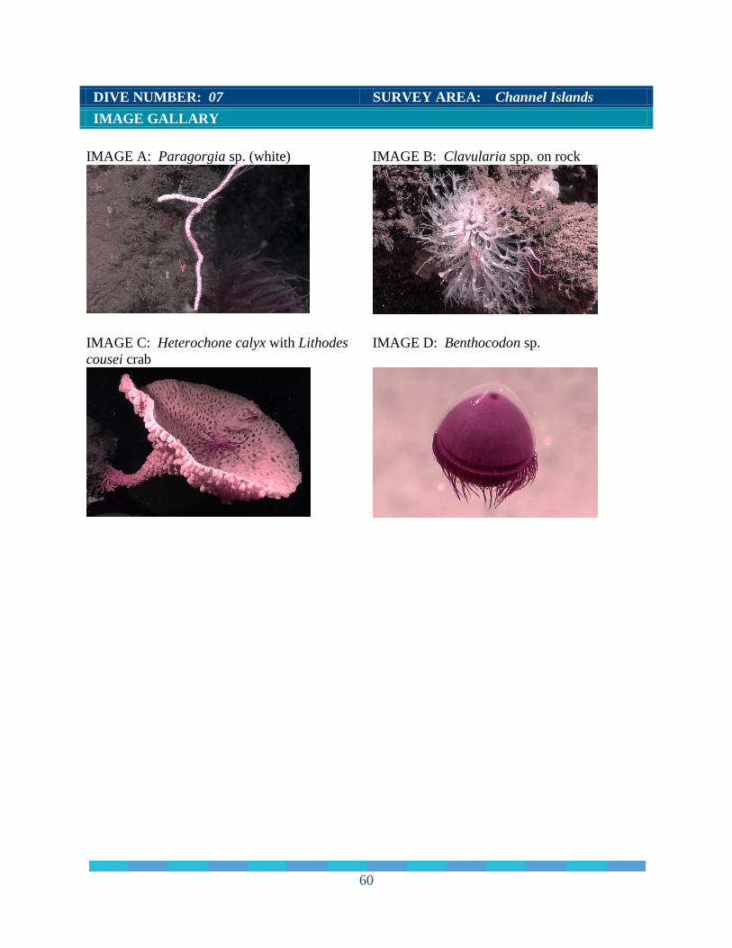
DIVE NUMBER: 07 SURVEY AREA: Channel Islands IMAGE GALLARY IMAGE A: Paragorgia sp. (white)
IMAGE B: Clavularia spp. on rock
IMAGE C: Heterochone calyx with Lithodes cousei crab
IMAGE D: Benthocodon sp.
60
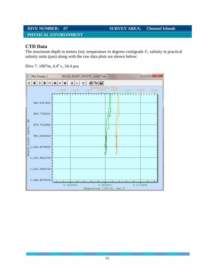
DIVE NUMBER: 07 SURVEY AREA: Channel Islands PHYSICAL ENVIRONMENT CTD Data The maximum depth in meters (m), temperature in degrees centigrade ©, salinity in practical salinity units (psu) along with the raw data plots are shown below: Dive 7: 1007m, 4.4o c, 34.4 psu
61
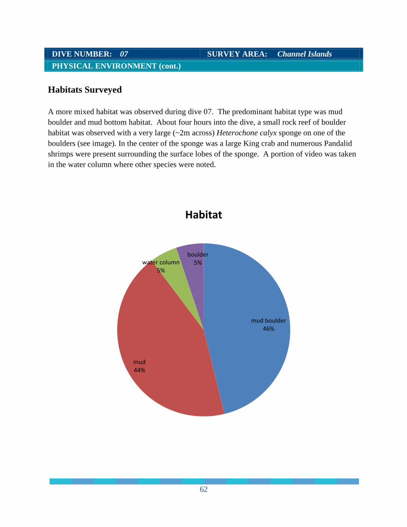
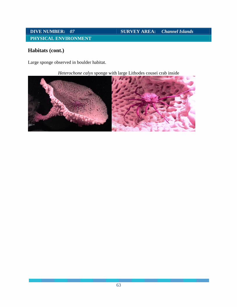
DIVE NUMBER: 07 SURVEY AREA: Channel Islands PHYSICAL ENVIRONMENT (cont.) Habitats Surveyed A more mixed habitat was observed during dive 07. The predominant habitat type was mud boulder and mud bottom habitat. About four hours into the dive, a small rock reef of boulder habitat was observed with a very large (~2m across) Heterochone calyx sponge on one of the boulders (see image). In the center of the sponge was a large King crab and numerous Pandalid shrimps were present surrounding the surface lobes of the sponge. A portion of video was taken in the water column where other species were noted.
mud boulder 46%
mud 44%
water column 5%
boulder 5%
Habitat
62
DIVE NUMBER: 07 SURVEY AREA: Channel Islands PHYSICAL ENVIRONMENT
Habitats (cont.) Large sponge observed in boulder habitat.
Heterochone calyx sponge with large Lithodes cousei crab inside
63
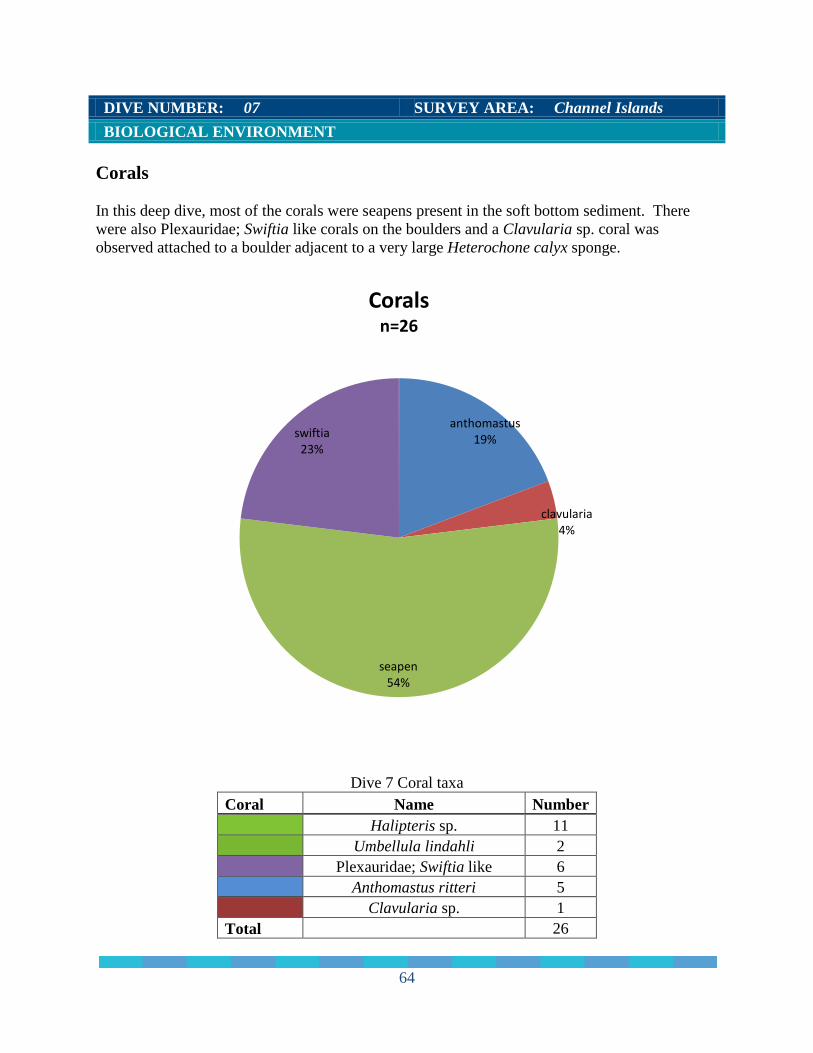
DIVE NUMBER: 07 SURVEY AREA: Channel Islands BIOLOGICAL ENVIRONMENT Corals In this deep dive, most of the corals were seapens present in the soft bottom sediment. There were also Plexauridae; Swiftia like corals on the boulders and a Clavularia sp. coral was observed attached to a boulder adjacent to a very large Heterochone calyx sponge.
Dive 7 Coral taxa
Coral Name Number
Halipteris sp. 11
Umbellula lindahli 2
Plexauridae; Swiftia like 6
Anthomastus ritteri 5
Clavularia sp. 1
Total
26
anthomastus 19%
clavularia 4%
seapen 54%
swiftia 23%
Corals n=26
64
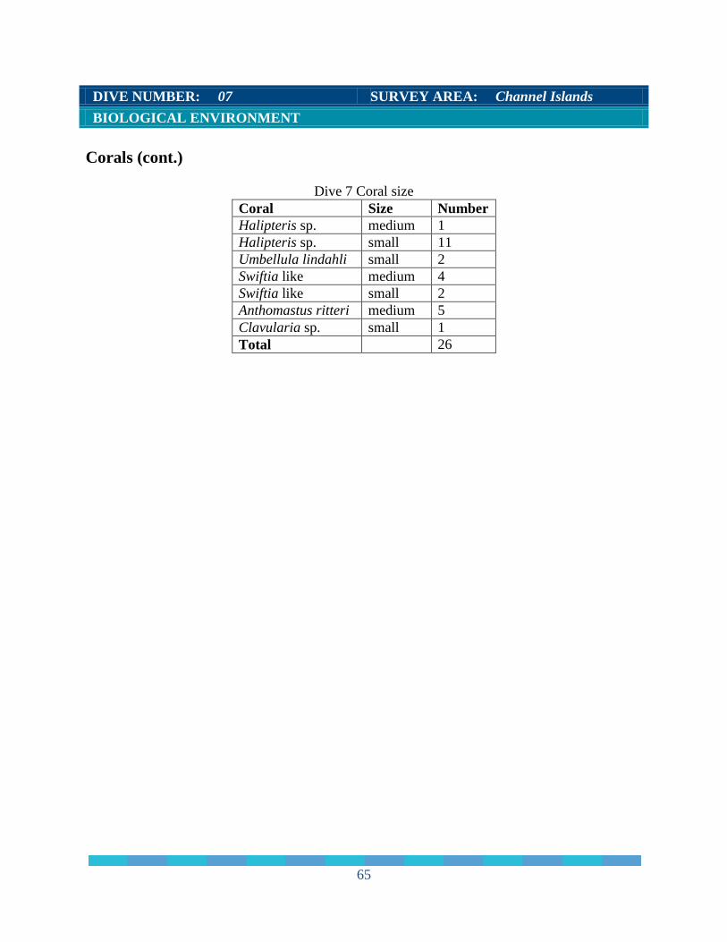
DIVE NUMBER: 07 SURVEY AREA: Channel Islands BIOLOGICAL ENVIRONMENT Corals (cont.)
Dive 7 Coral size Coral Size Number Halipteris sp. medium 1 Halipteris sp. small 11 Umbellula lindahli small 2 Swiftia like medium 4 Swiftia like small 2 Anthomastus ritteri medium 5 Clavularia sp. small 1 Total 26
65
DIVE NUMBER: 07 SURVEY AREA: Channel Islands BIOLOGICAL ENVIRONMENT
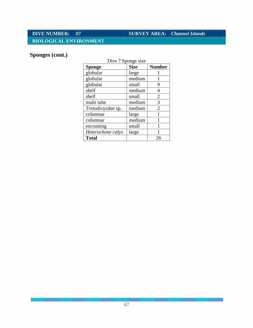
Sponges Dive 07 was observed to have a large diversity of sponges. Most of the sponge morphs were small globular sponges. There were a few medium shelf and multi-tube morphs noted in the rock reef area. There was one large Heterochone calyx sponge observed (˜2m across).
Dive 7 Sponge morphology
Sponge Morph Scientific name Number
globular
11
shelf
6
multi tube
3
Tretodictyidae sp. 2
columnar 2 encrusting 1 Heterochone calyx 1 Total
26
columnar 8%
encrusting 4%
globular 42%
heterochone calyx 4%
multi-tube 11%
shelf 23%
tretodictyidae 8%
Sponges n=26
66
DIVE NUMBER: 07 SURVEY AREA: Channel Islands BIOLOGICAL ENVIRONMENT Sponges (cont.)
Dive 7 Sponge size Sponge Size Number globular large 1 globular medium 1 globular small 9 shelf medium 4 shelf small 2 multi tube medium 3 Tretodictyidae sp. medium 2 columnar large 1 columnar medium 1 encrusting small 1 Heterochone calyx large 1 Total 26
67
DIVE NUMBER: 07 SURVEY AREA: Channel Islands BIOLOGICAL ENVIRONMENT
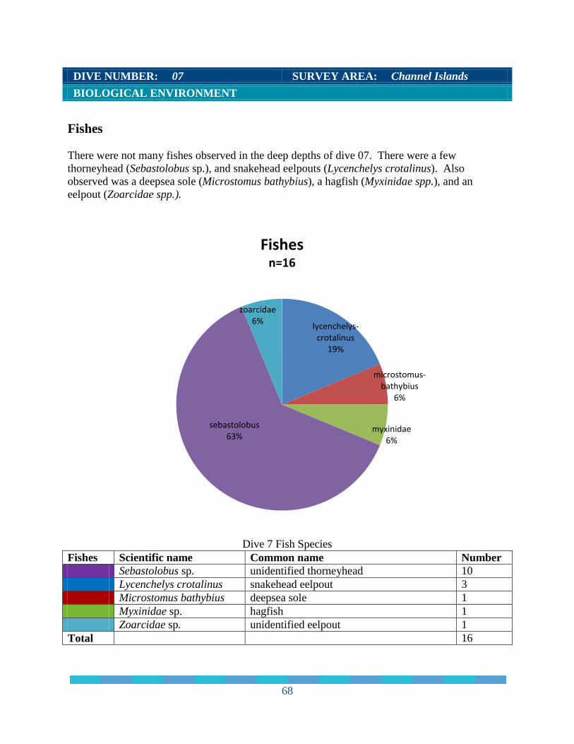
Fishes There were not many fishes observed in the deep depths of dive 07. There were a few thorneyhead (Sebastolobus sp.), and snakehead eelpouts (Lycenchelys crotalinus). Also observed was a deepsea sole (Microstomus bathybius), a hagfish (Myxinidae spp.), and an eelpout (Zoarcidae spp.).
Dive 7 Fish Species
Fishes Scientific name Common name Number Sebastolobus sp. unidentified thorneyhead 10 Lycenchelys crotalinus snakehead eelpout 3 Microstomus bathybius deepsea sole 1 Myxinidae sp. hagfish 1 Zoarcidae sp. unidentified eelpout 1 Total 16
lycenchelys-crotalinus
19%
microstomus-bathybius
6%
myxinidae 6%
sebastolobus 63%
zoarcidae 6%
Fishes n=16
68
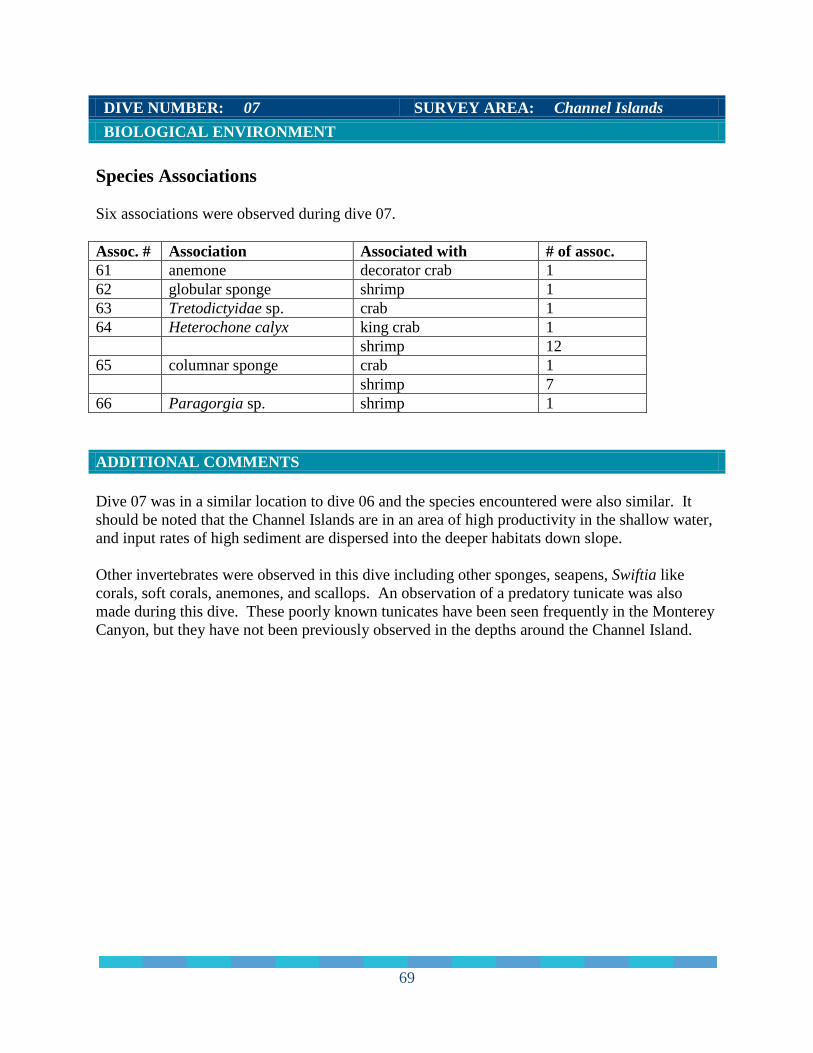
DIVE NUMBER: 07 SURVEY AREA: Channel Islands BIOLOGICAL ENVIRONMENT Species Associations Six associations were observed during dive 07. Assoc. # Association Associated with # of assoc. 61 anemone decorator crab 1 62 globular sponge shrimp 1 63 Tretodictyidae sp. crab 1 64 Heterochone calyx king crab 1 shrimp 12 65 columnar sponge crab 1 shrimp 7 66 Paragorgia sp. shrimp 1 ADDITIONAL COMMENTS Dive 07 was in a similar location to dive 06 and the species encountered were also similar. It should be noted that the Channel Islands are in an area of high productivity in the shallow water, and input rates of high sediment are dispersed into the deeper habitats down slope. Other invertebrates were observed in this dive including other sponges, seapens, Swiftia like corals, soft corals, anemones, and scallops. An observation of a predatory tunicate was also made during this dive. These poorly known tunicates have been seen frequently in the Monterey Canyon, but they have not been previously observed in the depths around the Channel Island.
69
CONCLUSION For this survey, seven dives were conducted and six were inside the sanctuary boundary. Depths for the six dives within the sanctuary ranged from 745 m to 886 m and the depth for the seventh dive outside the sanctuary reached 1,014 m. The first dive of the survey was an engineering dive, this site was chosen to provide even low relief terrain. The bottom was dominated by low relief, low gradient soft sediment with occasional small rock outcrops. Both dives 2 and 4 were aborted due to mechanical issues. The seafloor during dive 3 was predominantly covered in heavy sediment with a few occasional outcrops hosting sessile organisms. Sponge species diversity was high and there were 152 sponges observed during the dive with many different sponge morphs represented. The habitat of dive 5 was similar to dive 3, dominated by soft mud sediment with occasional small to medium sized rock boulders or outcrops. The rock outcrops were almost completely colonized by benthic invertebrates. Coral species diversity was high, with at least eight coral species identified including 136 Plexauridae; Swiftia like corals. A total of 57 sponges were observed during dive 5, approximately two-thirds fewer than in dive 3. Although dive 6 was in predominantly mud habitat there were some areas of mud wall. The steep wall was heavily sedimented and indicates lamina of historic sedimentation. Corals observed during this dive were primarily seapens at the deeper depths in mud habitat. Most of the sponges observed during dive 6 were globular and columnar sponge morphs reflecting a lower sponge diversity than both dives 3 and 5. A more mixed habitat was observed during dive 7which was the deepest dive during the survey. The predominant habitat type was mud boulder and mud bottom habitat. About four hours into the dive, a small rock reef of boulder habitat was observed with a very large (~2m across) Heterochone calyx sponge on one of the boulders. In the center of the sponge was a large crab. Dive 7 was in a similar location to dive 6 and the species encountered were also similar even though dive 7 was a much deeper dive. Since the Channel Islands are in an area of high productivity in the shallow water, this productivity can reach the habitats at the deeper depths of dive 7 as the input rates travel down slope. The characterization of the deep-sea community and associated habitats for this cruise in the Channel Islands National Marine Sanctuary provides information that can be used in future surveys to monitor biodiversity of habitats and species richness. ACKNOWLEDGEMENTS Jennifer Bright would like to thank those at Olympic Coast National Marine Sanctuary (OCNMS) for allowing her to use the equipment and office space at the OCNMS offices in Port
70
Angeles, Washington. These individuals at OCNMS include Carol Bernthal, Superintendent, George Galasso, Deputy Superintendent, and Kevin Grant, Deputy Superintendent. I would especially like to thank Ed Bowlby, Research Coordinator for his ongoing efforts to keep her at OCNMS and often finding additional projects and funding sources. Additional acknowledgements include Liam Antrim, OCNMS Resource Protection Specialist, and Tom Laidig, NOAA Southwest Fisheries Science Center. Also, I would like to thank Danielle Lipski and Steve Katz with Channel Islands National Marine Sanctuary who gave her the opportunity to work on this project. REFERENCES References Boury-Esnault, N, and Klaus Rutzler (editors). 1997. Thesaurus of Sponge Morphology.
Smithsonian Contributions to Zoology, number 596. Bowlby, C.E., M.S. Brancato, J.A. Boutillier, J. Bright, and K. Brenkman. Observations of
Deep Coral and Sponge Assemblages in Olympic Coast National Marine Sanctuary during a 2008 ROV survey.
Bright, J. 2007. Abundance and Distribution of Structure-Forming Invertebrates and Fishes at the
Channel Islands “Footprint”. M.S. thesis, Washington State University, School of Earth and Environmental Science, Vancouver, WA. 66p.
C.E. and M.E. Clarke. 2007. State of the U.S. Deep Coral Ecosystems in the United States
Pacific Coast: California to Washington, pp. 109-154. In: SE Lumsden, Hourigan TF, Bruckner AW and Dorr G (eds.) The State of Deep Coral Ecosystems of the United States. NOAA Technical Memorandum CRCP-3. Silver Spring, MD 365 pp.
Cook, S.E., B. Burd, and K.W. Conway. 2008. Status of the glass sponge reefs in the Georgia
Basin. Mar Environ Res 66:S80–S86. Greene, H.G., M.M. Yoklavich, R.M. Starr, V.M. O'Connell, W.W. Wakefield, D.E. Sullivan,
J.E. McRea Jr, and G.M. Cailliet. 1999. A classification scheme for deep seafloor habitats. Marine benthic habitats and their living resources: monitoring, management and applications to Pacific Island countries. Oceanologica Acta 22:663-678.
Hourigan, TF, SE Clarke, G Dorr, AW Bruckner, S Brooke, and RP Stone. 2007. Deep Coral
Ecosystems of the United States: Introduction and National Overview, pp. 1-64. In: SE Lumsden, Hourigan TF, Bruckner AW and Dorr G (eds.) The State of Deep Coral Ecosystems of the United States. NOAA Technical Memorandum CRCP-3. Silver Spring, MD 365 pp. http://coris.noaa.gov/activities/deepcoral_rpt/
Hyland, J., C. Cooksey, E. Bowlby, M.S. Brancato, and S. Intelmann. 2005. A Pilot Survey of Deepwater Coral/Sponge Assemblages and their Susceptibility to Fishing/Harvest Impacts at
71

the Olympic Coast National Marine Sanctuary (OCNMS). Cruise Report for NOAA Ship McARTHUR II Cruise AR-04-04: Leg 2. NOAA Technical Memorandum NOS NCCOS 15. NOAA/NOS Center for Coastal Environmental Health and Biomolecular Research, Charleston, SC. 13 p. http://www.coastalscience.noaa.gov/documents/ar0404leg2.pdf
Lobecker, M. 2011. California shakedown cruise 2011: exploring California’s national marine sanctuaries. Okeanos Explorer Explorations. http://oceanexplorer.noaa.gov/okeanos/explorations/ex1101/welcome.html
Lovalvo, D. 2011. Little Hercules ROV http://oceanexplorer.noaa.gov/okeanos/explorations/10index/background/rov/rov..html
Love, M.S. and M. M. Yoklavich, 2007. Habitat Characteristics of juvenile cowcod, Sebastes
levis (Schorpaenidae), in southern California. Environ. Biol. Fishes 10.1007/s10641-007-9290-x.
National Oceanic and Atmospheric Administration (NOAA). 2010a. NOAA Strategic Plan for
Deep-Sea Coral and Sponge Ecosystems: Research, Management, and International Cooperation. Silver Spring, MD: NOAA Coral Reef Conservation Program. NOAA Technical Memorandum CRCP 11. 67 pp. http://coris.noaa.gov/activities/deepsea_coral/
National Oceanic and Atmospheric Administration (NOAA). 2010b. NOAA Deep-Sea Coral
FY2010 Science Plan for the U.S. West Coast. National Oceanic and Atmospheric Administration (NOAA). 2011. Olympic Coast National
Marine Sanctuary Final Management Plan and Environmental Assessment. Office of National Marine Sanctuaries. Silver Spring, MD.
National Research Council (NRC). 2002. Effects of trawling and dredging on seafloor habitat.
National Academy Press, Washington, D.C. 136 pp. Stierhoff, K.L., P.J. Etnoyer, D.W. Murfin, and J.L. Butler. 2011. A survey of deep-water
coral and sponge habitats along the West Coast of the U.S. using a remotely operated vehicle. NOAA Technical Memorandum NOS NCCOS 138. NOAA Centers for Coastal Environmental Health and Biomolecular Research, Charleston, SC. 38 pp. http://www2.coastalscience.noaa.gov/publications/ccehbr/detail.aspx?resource=xyYY8+Vs2IWyXc8n343Z0pYibphi/R2GuAhSXhxDU1E=
Tissot, B. N. 2006. Video Analysis, Experimental Design, and Database Management of
Submersible-Based Habitat Studies: Marine Habitat Mapping Technology for Alaska, Alaska Sea Grant College Program, University of Alaska, Fairbanks, Alaska, doi: 104027/mhmta.2008.11.
Tissot, B., M. Yoklavich, M. Love, K. York, and M. Amend. 2006. Benthic Invertebrates that
form Habitat on Deep Banks off Southern California, with special reference to deep sea coral. Fishery Bulletin 104: 167-181
72
Whitmire, C.E. and M.E. Clarke. 2007. State of the U.S. Deep Coral Ecosystems in the United
States Pacific Coast: California to Washington, pp. 109-154. In: SE Lumsden, Hourigan TF, Bruckner AW and Dorr G (eds.) The State of Deep Coral Ecosystems of the United States. NOAA Technical Memorandum CRCP-3. Silver Spring, MD 365 pp.
Yoklavich, M,. 2010. U.S. West Coast Deep Coral Cruise Report http://www.swfsc.noaa.gov/publications/CR/2011/2011Yoklavich.pdf
73