Embed Size (px)
Citation preview
A China-EU electricity transmission link
Assessment of potential
connecting countries and
routes
Ardelean M., Minnebo P.
2017
EUR 29098 EN xx
This publication is a Science for Policy report by the Joint Research Centre (JRC), the European Commission’s
science and knowledge service. It aims to provide evidence-based scientific support to the European
policymaking process. The scientific output expressed does not imply a policy position of the European
Commission. Neither the European Commission nor any person acting on behalf of the Commission is
responsible for the use that might be made of this publication.
Contact information
Name: Mircea ARDELEAN
Address: European Commission, Joint Research Centre, NL-1755 ZG Petten – The Netherlands
Email: [email protected]
Tel.: +31-224-565387
JRC Science Hub
https://ec.europa.eu/jrc
JRC110333
EUR 29098 EN
PDF ISBN 978-92-79-79358-5 ISSN 1831-9424 doi:10.2760/67516
Luxembourg: Publications Office of the European Union, 2017
© European Union, 2017
Reuse is authorised provided the source is acknowledged. The reuse policy of European Commission documents is regulated by Decision 2011/833/EU (OJ L 330, 14.12.2011, p. 39).
For any use or reproduction of photos or other material that is not under the EU copyright, permission must be
sought directly from the copyright holders.
How to cite this report: Ardelean, M., Minnebo, P., A China-EU electricity transmission link. Assessment of
potential connecting countries and routes, EUR 29098 EN, Publications Office of the European Union,
Luxembourg, 2017, ISBN 978-92-79-79358-5, doi:10.2760/67516, JRC110333
A China-EU electricity transmission link. Assessment of potential connecting countries and routes
The report looks at the potential routes for a future power interconnection between EU and China. High voltage
direct current technology is considered and its potential is assessed. It analyses the renewable energy sources
in the countries along the potential routes as well as the power sector and power grid in the countries crossed.
Three potential routes are analysed.
i
Contents
Executive summary ............................................................................................... 1
Scope .................................................................................................................. 2
1 Introduction ....................................................................................................... 3
1.1 History of high voltage direct current installations and technological progress ..... 3
1.2 Present installations and stage of development ................................................ 4
1.3 Modern trends in HVDC technology ................................................................ 7
2 HVDC Technology ............................................................................................... 8
2.1 Convertors .................................................................................................. 8
2.1.1 Components ......................................................................................... 9
2.1.2 Types of converters ............................................................................... 9
2.2 Multi-terminal DC systems .......................................................................... 10
2.3 DC vs AC .................................................................................................. 12
2.3.1 Technical performances ....................................................................... 13
2.3.2 Reliability ........................................................................................... 13
2.3.3 Failures and protection measures .......................................................... 13
2.3.4 Cost .................................................................................................. 14
2.3.5 Parallel use of AC and DC ..................................................................... 15
2.4 HVDC industry ........................................................................................... 16
2.4.1 HVDC equipment manufacturers ........................................................... 16
2.4.2 HVDC interconnection operators ........................................................... 17
2.4.3 The cost of HVDC infrastructure ............................................................ 17
3 Central Asian countries ..................................................................................... 19
3.1 Afghanistan ............................................................................................... 19
3.2 Azerbaijan ................................................................................................ 21
3.3 China ....................................................................................................... 23
3.4 Georgia .................................................................................................... 28
3.5 India ........................................................................................................ 30
3.6 Iran ......................................................................................................... 33
3.7 Kazakhstan ............................................................................................... 35
3.8 Kyrgyzstan................................................................................................ 38
3.9 Mongolia ................................................................................................... 40
3.10 Myanmar ................................................................................................ 42
3.11 Pakistan .................................................................................................. 45
3.12 Tajikistan ................................................................................................ 47
3.13 Turkmenistan .......................................................................................... 49
3.14 Uzbekistan .............................................................................................. 50
ii
3.15 Black Sea ................................................................................................ 52
3.16 Caspian Sea ............................................................................................ 54
4 China-Europe HVDC link .................................................................................... 55
4.1 Framework ............................................................................................... 55
4.2 Benefits .................................................................................................... 55
4.3 Drawbacks ................................................................................................ 58
4.4 RES potential and installed capacities ........................................................... 58
4.4.1 Wind potential and installed capacities ................................................... 58
4.4.2 Solar potential and installed capacities ................................................... 65
4.4.3 North-east China ................................................................................. 74
4.5 Possible routes .......................................................................................... 76
4.5.1 Scenario 1 – North route ...................................................................... 76
4.5.2 Scenario 2 – Middle route .................................................................... 77
4.5.3 Scenario 3 – South route ..................................................................... 78
4.6 DC infrastructure in target countries ............................................................ 79
4.7 DC technology experience in target countries ................................................ 81
4.8 Geopolitical issues ..................................................................................... 81
4.9 Environmental conditions ............................................................................ 81
4.10 Estimated cost ......................................................................................... 82
Conclusions ........................................................................................................ 83
Bibliography ....................................................................................................... 84
Annex 1 – List of HVDC interconnections ................................................................ 87
Annex 2 – Load profile scenarios ........................................................................... 95
Annex 3 – Potential routes scenarios’ profiles ......................................................... 96
Annex 4 – Conflicts areas in Central Asia ................................................................ 97
List of figures ...................................................................................................... 98
1
Executive summary
In their vast majority the national power transmission and distribution networks operate
with alternating current but the latest developments in direct current technology make
this technology the best option for large quantities of electricity transmitted over long
distances. The proof stands in the increasing number of such installation across the
world (almost 200). China is by far the largest market for high voltage direct current
(HVDC) equipment and systems and it holds the complete solution from designing to
manufacturing and installing such systems. Nevertheless, the most innovative companies
are Europe-based.
China has launched in 2016 the idea of transmitting electricity as far as Germany via an
UHVDC link. This purpose falls under a more comprehensive initiative called “Belt and
Road Initiative”, which has the ambition to export industrial overcapacity and
engineering expertise as it faces slowing growth at home.
Central Asia is a realm with rich potential in renewable energy sources (RES), mainly
wind and solar (but also hydro) which can yield large quantities of “clean” electricity.
China intends to exploit its RES from north-eastern regions both for domestic use and for
export. The country has the capabilities to project and build long and powerful systems
to transmit electricity across the country for thousands of kilometres.
Three route scenarios are considered and analysed, all starting in rich in RES areas in
western China and heading towards Europe on three different paths. Each of the routes
displays advantages and drawbacks. The north route is the shortest one and crosses the
lowest number of countries. It is entirely on land and has no major natural barriers. It
crosses parts of Russia and eastern Ukraine. The middle route is longer than the
previous one and crosses a larger number of countries but with richer potential of RES.
It also involves crossing two sea bodies. The third route, the southern one, is the longest
and crosses the larger number of states. It is entirely on land and crosses several
rougher natural environments like mountains, high plateaus and deserts, as well as few
conflict areas.
The DC technology is present in several countries (China, India) with notable
contributions, generally the area lack this type of infrastructure. The same goes for DC
technology knowledge and experience.
Although the technology is mature enough for such a project to be built, the scope and
benefit share must be still envisaged. The multi-terminal configuration would be the best
solution to be adopted but more trials are needed in order to prove their robustness.
The investment cost varies largely according to the route chosen. The length and
number of countries crossed (which give the number of converter stations needed) are
the variables that influence the cost the most. The cost for such an infrastructure spans
from €15-16 billion in the case of the shortest one and with the lowest number of
countries crossed to €23-28 billion for the longer ones, crossing more countries and
implying the use of submarine power cables.
2
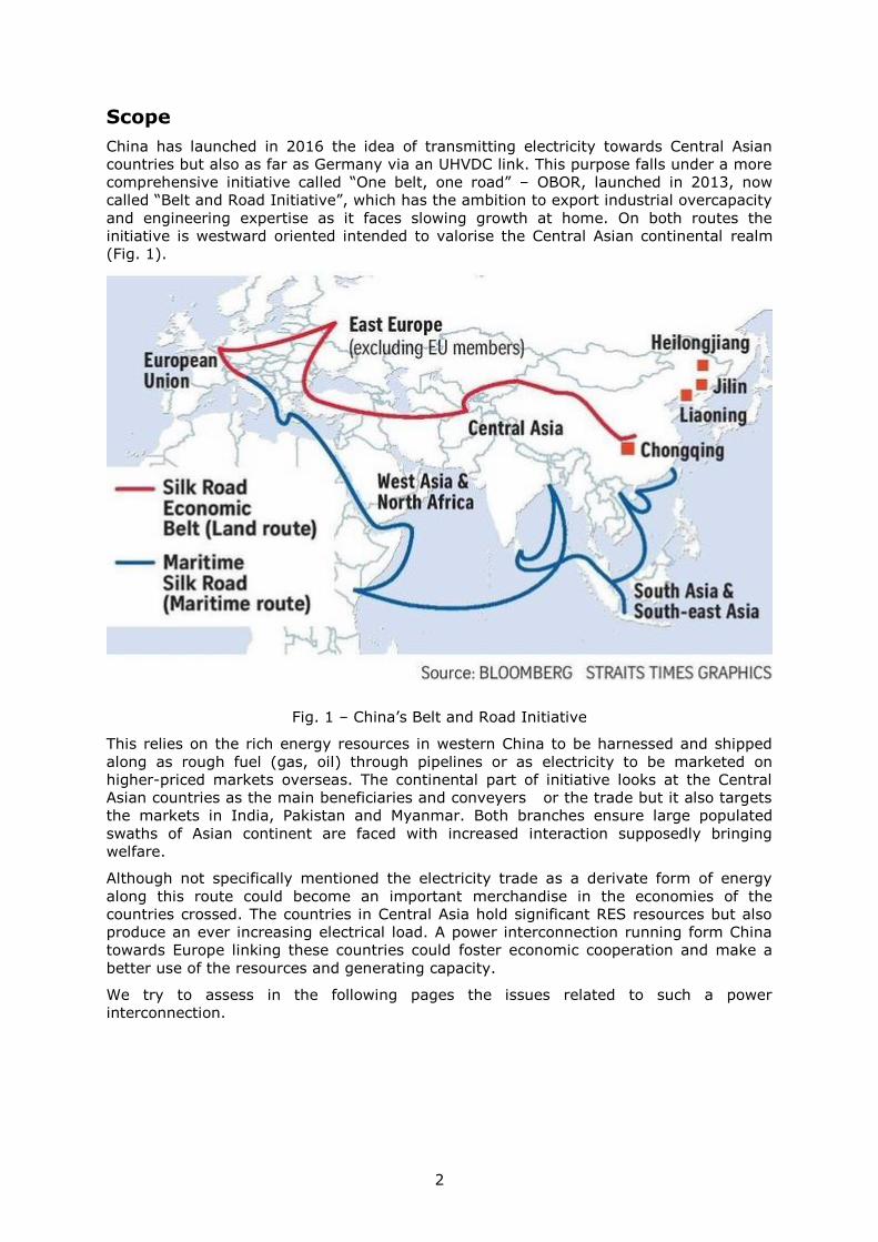
Scope
China has launched in 2016 the idea of transmitting electricity towards Central Asian
countries but also as far as Germany via an UHVDC link. This purpose falls under a more
comprehensive initiative called “One belt, one road” – OBOR, launched in 2013, now
called “Belt and Road Initiative”, which has the ambition to export industrial overcapacity
and engineering expertise as it faces slowing growth at home. On both routes the
initiative is westward oriented intended to valorise the Central Asian continental realm
(Fig. 1).
Fig. 1 – China’s Belt and Road Initiative
This relies on the rich energy resources in western China to be harnessed and shipped
along as rough fuel (gas, oil) through pipelines or as electricity to be marketed on
higher-priced markets overseas. The continental part of initiative looks at the Central
Asian countries as the main beneficiaries and conveyers or the trade but it also targets
the markets in India, Pakistan and Myanmar. Both branches ensure large populated
swaths of Asian continent are faced with increased interaction supposedly bringing
welfare.
Although not specifically mentioned the electricity trade as a derivate form of energy
along this route could become an important merchandise in the economies of the
countries crossed. The countries in Central Asia hold significant RES resources but also
produce an ever increasing electrical load. A power interconnection running form China
towards Europe linking these countries could foster economic cooperation and make a
better use of the resources and generating capacity.
We try to assess in the following pages the issues related to such a power
interconnection.
3
1 Introduction
The global electrical consumption experienced a constant increase during the last
decades, continuing its upward trend in future, despite the measures taken to increase
the energy efficiency. The use of electricity is present in almost every aspect of our daily
lives, in all economic activities and forms the basis of many other activities and services
of critical importance (communication, security, internet etc.).
Electricity is a secondary form of energy derived from other primary types: mechanical
(wind, hydro), thermal (coal, gas, nuclear), chemical (batteries), optic (solar). The
spread of these resources is not even around the globe. They are concentrated in few
places depending on the local geological history (for fossil fuels and geothermal) or
geographical conditions (hydro, wind and solar). Once electricity is produced, it cannot
be efficiently stored - at least not in large quantities with nowadays technologies, thus it
has to be immediately consumed. Generation and consumption must be balanced in real
time so the two must be linked. Until now the closest energy resources to human
communities were exploited, but in the future, in order to cover the electricity demand,
more distant resources would have to be accessed. Electricity usually produced in situ
has to be transmitted to the areas with high demand which necessitates power
transmission lines to be built. Power transmission over large distances, with the lowest
costs and losses is done by using high voltage transmission lines. Most of the national
power networks rely on a transmission frame composed of high voltage lines functioning
on alternating current (AC). Relatively recently many high voltage direct current (HVDC)
transmission lines are being construct and used to transmit large quantities of electricity
over long distances.
The idea of an HVDC transmission line between China and Europe has been supported by
the State Grid Company of China (SGCC), based on European countries goals of reducing
the carbon footprint and to decrease nuclear energy in the future in conjunction with
accessing the rich renewable energy sources (RES) in Central Asia.
1.1 History of high voltage direct current installations and technological progress
In their vast majority national power transmission and distribution networks function
with AC as it offers a series of advantages which are presented later on in this report.
Lately, electricity demand increased and it continues to do so which entails the necessity
to find solutions for transferring large quantities of electricity from power plants,
especially those of large production, to the large urban consumption centres. This was
and still is possible with the help of AC power networks. Direct current (DC) offers
however a series of advantages among which the increased power control and fewer
transmission losses are the most important ones. This explains the great increase in the
number of HVDC projects foreseen in the years to come.
Except for few experimental and sporadic trials before 1950s, DC was not used on a
large scale in electricity distribution. Only in 1954 the Swedish company ASEA installed
the first operational line of 30 MW at 150 kV between mainland Sweden and Gotland
Island, which was a submarine power cable of 100 km length. In the 1960s a series of
HVDC transmission lines were built, all as submarine cables (with the exception of the
overhead line (OHL) Volgograd-Donbass in the USSR) between United Kingdom and
France, the Danish islands, the New Zealand islands, between Vancouver Island and
mainland Canada and between Sardinia Island and mainland Italy. Once with the
increasing distance the values of the functioning parameters grow as well – capacity and
voltage. The Swedish company ASEA, pioneer in designing, testing and installing such
systems was the main producer of these systems in this period.
The three next decades (1970s, 1980s, and 1990s) represent a continuation of the
tendency started in the previous decade. More than 35 HVDC projects have been
accomplished during this period, some in already established areas (Danish archipelago,
4
Gotland Island), as submarine power cables, but other mainly as powerful OHL with ever
higher voltages, linking generally high capacity hydro power plants with consumption
centres located hundreds of kilometres away. Such projects were achieved in North
America (US, Canada), South America (Brazil), Asia (India, China, Philippines) and Africa
(Mozambique, South Africa, Democratic Republic of Congo). The power of these systems
achieves and even exceeds in few cases 2000 MW for a voltage of 250-500 kV. Many of
these systems have been modernized in the last years, although few have been
abandoned or replaced by modern circuits. In this period, besides ASEA, companies from
other areas start to play a role in the HVDC market equipment (ABB, Alcatel, General
Electric, Siemens, AEG, Hitachi, Toshiba, Areva) or specialize on specific segments, such
as submarine cables (Prysmian).
Starting with 2000s, due to important technological advances the number of the HVDC
projects has greatly increased, in the last 17 years going online twice as many projects
as during the previous period. The transmission lines become more powerful at voltages
ever higher. If at the beginning of the period HVDC technology was still used as a
solution to transmit electricity between regions separated by aquatic bodies, as
submarine power cables, towards nowadays it becomes more a solution for trade
between countries and to balance the power budget between different regions of the
same country or of the same continent.
Even closer to nowadays it is noted an increase of the voltage towards the Ultra High
Voltage (UHV) zone, of ±800 kV and beyond. China is the promoter of this tendency with
all such projects built, except for few in India. The great number of such projects
accomplished or being in various stages of achievement or planning indicates that this
technology has reached maturity. The tendency towards even greater voltages continues
as China plans at least three UHVDC projects of 1100 kV. All these UHVDC projects are
meant to transmit power from the future hydro power plants in south-central provinces
(Sichuan, Yunnan) to the big consumer centres on the eastern coast.
1.2 Present installations and stage of development
A glance at the distribution of the HVDC projects worldwide (Fig. 2) shows the
undeniable pre-eminence of the Eurasian bloc both in terms of number of projects as
well as length of lines. It is followed by North America, Africa and South America, despite
the fact that on the last two some of the largest projects both in terms of capacity and
length were built at the end of 1970s and 1980s. Australia and New Zealand possess
also several HVDC projects.
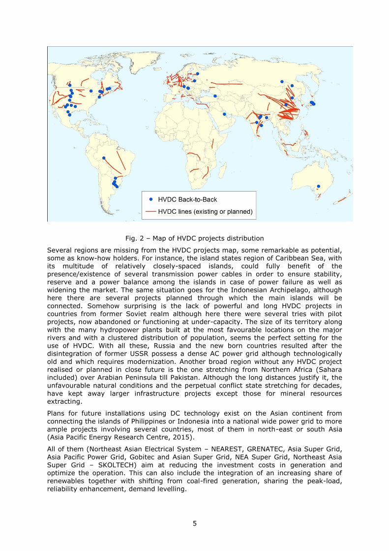
5
Fig. 2 – Map of HVDC projects distribution
Several regions are missing from the HVDC projects map, some remarkable as potential,
some as know-how holders. For instance, the island states region of Caribbean Sea, with
its multitude of relatively closely-spaced islands, could fully benefit of the
presence/existence of several transmission power cables in order to ensure stability,
reserve and a power balance among the islands in case of power failure as well as
widening the market. The same situation goes for the Indonesian Archipelago, although
here there are several projects planned through which the main islands will be
connected. Somehow surprising is the lack of powerful and long HVDC projects in
countries from former Soviet realm although here there were several tries with pilot
projects, now abandoned or functioning at under-capacity. The size of its territory along
with the many hydropower plants built at the most favourable locations on the major
rivers and with a clustered distribution of population, seems the perfect setting for the
use of HVDC. With all these, Russia and the new born countries resulted after the
disintegration of former USSR possess a dense AC power grid although technologically
old and which requires modernization. Another broad region without any HVDC project
realised or planned in close future is the one stretching from Northern Africa (Sahara
included) over Arabian Peninsula till Pakistan. Although the long distances justify it, the
unfavourable natural conditions and the perpetual conflict state stretching for decades,
have kept away larger infrastructure projects except those for mineral resources
extracting.
Plans for future installations using DC technology exist on the Asian continent from
connecting the islands of Philippines or Indonesia into a national wide power grid to more
ample projects involving several countries, most of them in north-east or south Asia
(Asia Pacific Energy Research Centre, 2015).
All of them (Northeast Asian Electrical System – NEAREST, GRENATEC, Asia Super Grid,
Asia Pacific Power Grid, Gobitec and Asian Super Grid, NEA Super Grid, Northeast Asia
Super Grid – SKOLTECH) aim at reducing the investment costs in generation and
optimize the operation. This can also include the integration of an increasing share of
renewables together with shifting from coal-fired generation, sharing the peak-load,
reliability enhancement, demand levelling.
6
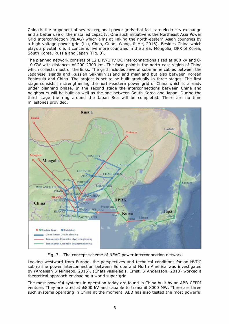
China is the proponent of several regional power grids that facilitate electricity exchange
and a better use of the installed capacity. One such initiative is the Northeast Asia Power
Grid Interconnection (NEAG) which aims at linking the north-eastern Asian countries by
a high voltage power grid (Liu, Chen, Guan, Wang, & He, 2016). Besides China which
plays a pivotal role, it concerns five more countries in the area: Mongolia, DPR of Korea,
South Korea, Russia and Japan (Fig. 3).
The planned network consists of 12 EHV/UHV DC interconnections sized at 800 kV and 8-
10 GW with distances of 200-2300 km. The focal point is the north-east region of China
which collects most of the links. The grid includes several submarine cables between the
Japanese islands and Russian Sakhalin Island and mainland but also between Korean
Peninsula and China. The project is set to be built gradually in three stages. The first
stage consists in strengthening the north-eastern power grid of China which is already
under planning phase. In the second stage the interconnections between China and
neighbours will be built as well as the one between South Korea and Japan. During the
third stage the ring around the Japan Sea will be completed. There are no time
milestones provided.
Fig. 3 – The concept scheme of NEAG power interconnection network
Looking westward from Europe, the perspectives and technical conditions for an HVDC
submarine power interconnection between Europe and North America was investigated
by (Ardelean & Minnebo, 2015). (Chatzivasileiadis, Ernst, & Andersson, 2013) worked a
theoretical approach envisaging a world super-grid.
The most powerful systems in operation today are found in China built by an ABB-CEPRI
venture. They are rated at ±800 kV and capable to transmit 8000 MW. There are three
such systems operating in China at the moment. ABB has also tested the most powerful
7
HVDC transformer up-to-date which will be used for the Changji-Guquan HVDC line built
in cooperation with CEPRI until 2019. It will be able to carry 12000 MW of electricity and
it is rated at ±1100 kV. INELFE (HVDC interconnection between France and Spain) is at
the moment the most powerful VSC installation in the world, rated at 2000 MW, with two
parallel bipolar circuits (1000 MW each) (Siemens, 2015). The highest voltage from
terminal to terminal for a submarine HVDC cable (2012) is found at NorNed, rated at
900 kV (±450 kV).
1.3 Modern trends in HVDC technology
The ever increasing demand for using such technology orients the tendencies for its
modernization towards cost reduction for equipment production and installing as well as
towards the increase of the functioning parameters (capacity, ratings).
As the main component of an HVDC system is the converter it is the focal element
targeted for cost reduction. The cost reduction focuses on reducing the number of
components. Also the increase of the current and voltage as well as the cost of the
valves by using new materials are among the main concerns for cost reduction.
Among the technical modernization we can count:
A new valve design for an increase safety in earthquake prone areas;
Better cooling methods for thyristors in order to increase their rating; the power
of a 12 pulse conversion unit exceeds today 3000 MW;
Use of microcomputer equipment to control the convertors with multiple
advantages ranging from redundant converter control to allowing scheduled
maintenance to be performed while the converter is in operation;
Conversion of HVAC lines into HVDC ones due to the right-of-way (ROW)
limitations which demands the use of the same couloir to transmit more power;
Operating with insufficient powerful AC systems;
Development of HVDC transmission above 800 kV.
8
2 HVDC Technology
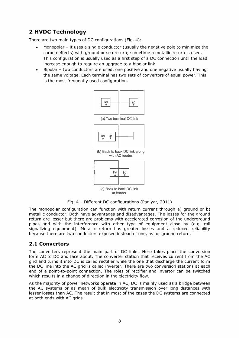
There are two main types of DC configurations (Fig. 4):
Monopolar – it uses a single conductor (usually the negative pole to minimize the
corona effects) with ground or sea return; sometime a metallic return is used.
This configuration is usually used as a first step of a DC connection until the load
increase enough to require an upgrade to a bipolar link.
Bipolar – two conductors are used, one positive and one negative usually having
the same voltage. Each terminal has two sets of convertors of equal power. This
is the most frequently used configuration.
Fig. 4 – Different DC configurations (Padiyar, 2011)
The monopolar configuration can function with return current through a) ground or b)
metallic conductor. Both have advantages and disadvantages. The losses for the ground
return are lesser but there are problems with accelerated corrosion of the underground
pipes and with the interference with other type of equipment close by (e.g. rail
signalizing equipment). Metallic return has greater losses and a reduced reliability
because there are two conductors exposed instead of one, as for ground return.
2.1 Convertors
The converters represent the main part of DC links. Here takes place the conversion
form AC to DC and face about. The converter station that receives current from the AC
grid and turns it into DC is called rectifier while the one that discharge the current form
the DC line into the AC grid is called inverter. There are two conversion stations at each
end of a point-to-point connection. The roles of rectifier and invertor can be switched
which results in a change of direction in the electricity flow.
As the majority of power networks operate in AC, DC is mainly used as a bridge between
the AC systems or as mean of bulk electricity transmission over long distances with
lesser losses than AC. The result that in most of the cases the DC systems are connected
at both ends with AC grids.
9
2.1.1 Components
The converters consist of a series of valves that allow the current to flow in one direction
but block it reversely. Two main types of valves are currently used: thyristor valves and
Insulated Gate Bipolar Transistor (IGBT) valves which also define different types of
HVDC technology – Line Commutated Converters (LCC) and Voltage Source Converters
(VSC) (Padiyar, 2011).
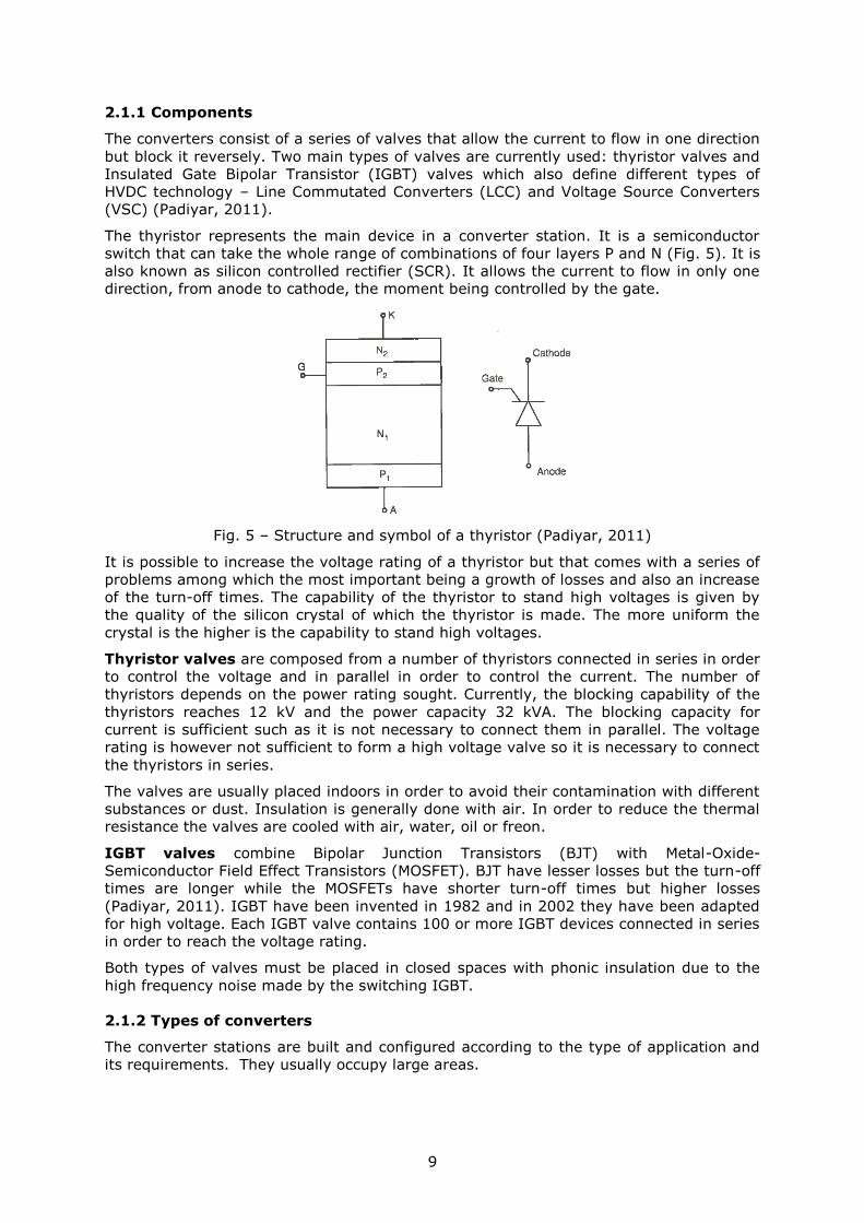
The thyristor represents the main device in a converter station. It is a semiconductor
switch that can take the whole range of combinations of four layers P and N (Fig. 5). It is
also known as silicon controlled rectifier (SCR). It allows the current to flow in only one
direction, from anode to cathode, the moment being controlled by the gate.
Fig. 5 – Structure and symbol of a thyristor (Padiyar, 2011)
It is possible to increase the voltage rating of a thyristor but that comes with a series of
problems among which the most important being a growth of losses and also an increase
of the turn-off times. The capability of the thyristor to stand high voltages is given by
the quality of the silicon crystal of which the thyristor is made. The more uniform the
crystal is the higher is the capability to stand high voltages.
Thyristor valves are composed from a number of thyristors connected in series in order
to control the voltage and in parallel in order to control the current. The number of
thyristors depends on the power rating sought. Currently, the blocking capability of the
thyristors reaches 12 kV and the power capacity 32 kVA. The blocking capacity for
current is sufficient such as it is not necessary to connect them in parallel. The voltage
rating is however not sufficient to form a high voltage valve so it is necessary to connect
the thyristors in series.
The valves are usually placed indoors in order to avoid their contamination with different
substances or dust. Insulation is generally done with air. In order to reduce the thermal
resistance the valves are cooled with air, water, oil or freon.
IGBT valves combine Bipolar Junction Transistors (BJT) with Metal-Oxide-
Semiconductor Field Effect Transistors (MOSFET). BJT have lesser losses but the turn-off
times are longer while the MOSFETs have shorter turn-off times but higher losses
(Padiyar, 2011). IGBT have been invented in 1982 and in 2002 they have been adapted
for high voltage. Each IGBT valve contains 100 or more IGBT devices connected in series
in order to reach the voltage rating.
Both types of valves must be placed in closed spaces with phonic insulation due to the
high frequency noise made by the switching IGBT.
2.1.2 Types of converters
The converter stations are built and configured according to the type of application and
its requirements. They usually occupy large areas.
10
2.1.2.1 Line Commutated Converter - LCC
LCC are the most used converters today. In LCC the current is kept constant. The
direction of the power flow is determined by the polarity of the DC voltage. The direction
of the current remains however the same. They allow the control of only the active
power and have no black start capabilities. LCCs use thyristor valves.
2.1.2.2 Voltage Source Converter - VSC
VSC allows independent control of both active and reactive power. This makes that in
VSC systems the converter station to be able to absorb or to provide reactive power to
the system, regulating thus the voltage. For that VSC uses IGBT which are able to turn
off the current. VSC can function at zero active power and still provide full range reactive
power.
The switch of flow direction does not require switching the voltage which allows for a
better control of the multi-terminal systems.
Converter stations occupy a much smaller space, they are standardized and modular
which makes them suitable for adaptation and extension in case of capacity increase.
In a VSC configuration it is much simpler to connect new substations to the existing
system which offer more options for feeding the grid or taking power from it.
(L'Abbate & Fulli, 2010) make a modelling analysis over the impact that HVDC-VSC
would have over a part of the European power grid. The analysis was carried at the 220-
00 kV voltage level and demonstrated the reduction of congestion by replacing several
HVAC lines with HVDC-VSC.
2.1.2.3 VSC vs LCC
The choice for the type of the HVDC technology holds on the quantity of transmitted
power, on the degree of control required and on the price. LCC is a mature technology
which a long use. VSC is still in developing phase with potential for improvement. VSC is
more expensive due to the equipment in the conversion station. VSC conversion stations
have higher losses (1.8-3%) than LCC (0.5-1).
As there is no grounding VSC technology is by its nature bipolar. The drawback is that in
the case of a failure or during the maintenance periods the systems must be completely
shut down with no possibility to diverge the current through another pole and
maintaining at least partially the functioning.
For the moment VSC has a series of limitations regarding the power capacity (200 MW)
and the maximum voltage which makes them suitable for power transmission produced
by wind farms. It is out of question for the moment to speak about a long distance and
high capacity VSC HVDC interconnection but this technology should be followed closely in
the years to come since it may at some point compete with classic HVDC.
2.2 Multi-terminal DC systems
The majority of HVDC systems built by now are point-to-point. Of these, most of them
are unidirectional conceived to transfer large quantities of electricity from a high capacity
power plant to the consumer centres with high demand. Most of the lines built in the last
period in China, India, Brazil and many others belong to this category as well as most of
the lines planned or being under construction in China. HVDC cables that bring the
electricity produced by offshore wind farms on shore belong to the same category. A
relatively reduced number of point-to-point systems allow a double flow of power. These
are conceived for mutual power exchange between two countries and take the form of
HVDC submarine power cables. Such systems can be found in larger number in Europe
but also in North America, Japan and Australia. Generally these systems consist out of a
OHL or cable connected at both ends to a converter station which at their turn can be
connected to a power plant or a AC grid.
11
There are a small number of systems that consist of more than two converter stations
and which allow power injection or power pull at other places than the two ends. These
are the multi-terminal systems and there are only three of them worldwide: SAPEI in
Europe (Italy-France), Quebec-New England in North America (Canada-US) and
Zhoushan in Asia (China). The complexity of such systems considerably increases in
order to ensure their stability.
Multi-terminal systems are used in a series of cases when it is necessary or more
advantageous that the electricity produced to be collected or distributed through more
points. Few examples below could clarify these situations:
The transmission of a large quantity of electricity produced by many power plants
and its distribution to many consumption centres. Each power plant would be
connected to a rectifier substation and for each exit there would be an invertor.
In this case the line would be common and it avoids building many parallel
transmission lines. The losses would drop by eliminating the duplicate lines. There
no more need for AC collector at the generation end which gives the turbine (in
case of a hydropower plant) the freedom to spin at a speed independent from the
system’s frequency.
Connecting asynchronous AC systems. This can be done through point-to-point
links but in this case the systems can interact only as a pair. When more than two
systems are involved the multi-terminal systems could be the optimal solution.
Reinforcing heavily loaded AC grids through multiple connecting points.
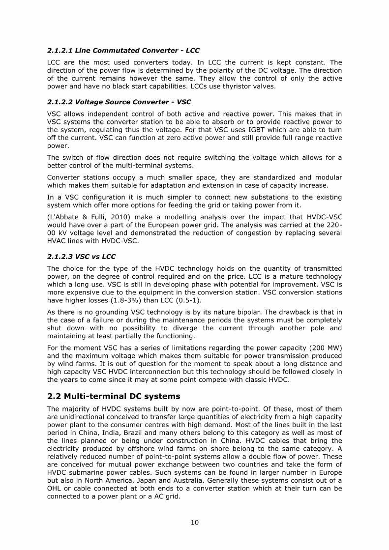
Multi-terminal systems can be configured as in series or as in parallel (Fig. 6).
12
a b
c
Fig. 6 – Multi-terminal DC systems in a) series, b) in parallel radial and c) in parallel
mesh
In series configuration offers more power leverage while the one in parallel allows a
gradually development according to the increase of power. The main issues for the in
series systems are the losses in line and isolation. The line failures stop the in series
systems while the unaffected lines and converter stations continue to run in parallel
systems.
In series systems are suited for tap ratings less than 20% from the power of the main
inverter. In parallel systems are adaptable according to the needs and will probably be
very much used in future. There are however a set of issues linked to the power flow
which have to be solved before these systems to become common.
Given the technical characteristics the VSC are well suited for multi-terminal
configuration due to their high capabilities of power control.
2.3 DC vs AC
The electric current is transmitted under two forms: alternating current (AC) and direct
current (DC). The choice for the type of current holds on three factors:
Cost (investment and operation)
Technical performances
Reliability
13
Depending on the situation and the required conditions all these factors can contribute in
choosing the type of current used or one of them can become decisive.
2.3.1 Technical performances
DC systems present a series of advantages that are not found in AC. These hold
especially on control and stability. The converter permits total control of power
transmitted.
The voltage control in AC systems is more complicated and implies the adjustment of
reactive power as the line becomes more loaded. This becomes more necessary with the
increase of the line length. For this reason, the AC line must be compensated for long
distances at regular intervals which means bigger problems for underground or
submarine cables. In Line Commutated Converters (LCC) DC systems it is also necessary
to control the reactive power but the line does not require additional reactive power to
maintain the voltage.
The power fluctuations in AC systems lead to frequency fluctuation which in turn
increases the risk of failure and can transmit the perturbations to its neighbouring
systems. When AC systems operate at different frequencies they cannot be directly
coupled. This can be done only through DC bridges (Back-to-Back – B2B or distance
interconnections). In these cases the DC system permits the control of power transfer
from one AC system to another.
AC systems have however a series of advantages among which, the most important one
is the easiness of changing the voltage level using the transformers. For bulk electricity
transmission over long distances high voltages are used while for distribution to small
power industrial or household consumers low voltage is used.
DC systems have on their side a series of drawbacks which hold mainly of:
difficulty to break the current which leads to higher costs for DC breakers
impossibility to use the transformers to increase or decrease the voltage
generating harmonics which necessitates the use of AC and DC filters which leads
to supplementary costs
increase in control complexity.
2.3.2 Reliability
The reliability of DC systems outperforms the one of AC, especially after the introduction
of thyristor valves, when it can reach 95%. In most of the cases the DC equipment has a
lower failure rate (9 to 147 years). The most vulnerable parts are the transmission
poles, with a failure rate of 1.25 years/100 km, but they are common to the AC systems
as well.
HVDC systems have the advantage that the power can be quickly controlled while
through the use of microprocessors the operation can be automatized.
2.3.3 Failures and protection measures
HVDC systems can be affected by failures triggered by various causes, but the most
common are:
faulty functioning of the controllers or equipment in general;
insulation deterioration due to external actions (lightning, pollution).
The deteriorations can stop the functioning of DC systems but they can also lead to an
abnormal operation forming over currents and over voltage which stress the equipment
and drive them out of operation. Special attention must be paid to the valves which need
particular protection against high temperature caused by the high losses produced by
over voltages.
14
Some failures could be eliminated through technological development as it is the case for
the backfire arcs specific to the mercury valves through which the core of the
transformers suffered major deteriorations. Modern converters do not use any longer
mercury arcs.
Other failures that can affect the converters’ equipment are arc through in the inverter
stations and misfire which if are transitory do not produce damage to the equipment or
abnormalities in functioning.
The dirt deposited on conductors and isolators on the poles are usually washed off by the
stronger rains but the fog and dew can cause the dirt accretions to trigger flashovers.
The solution is to operate the line at lower voltages.
2.3.4 Cost
The total cost can be split in the cost needed to build the infrastructure and the cost
needed to operate the system once it is functional. The investment cost considers the
poles, the conductors and insulation, converter stations as well as the right to use the
transmission couloir (right-of-way – ROW). The operational cost involves especially the
losses impact financially expressed.
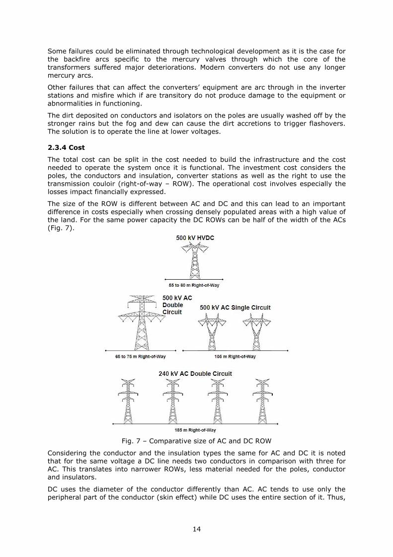
The size of the ROW is different between AC and DC and this can lead to an important
difference in costs especially when crossing densely populated areas with a high value of
the land. For the same power capacity the DC ROWs can be half of the width of the ACs
(Fig. 7).
Fig. 7 – Comparative size of AC and DC ROW
Considering the conductor and the insulation types the same for AC and DC it is noted
that for the same voltage a DC line needs two conductors in comparison with three for
AC. This translates into narrower ROWs, less material needed for the poles, conductor
and insulators.
DC uses the diameter of the conductor differently than AC. AC tends to use only the
peripheral part of the conductor (skin effect) while DC uses the entire section of it. Thus,
15
for the same diameter of the conductor DC transmits 30-40% more electricity than AC
which makes DC more efficient than AC and so the cost of the electricity unit transmitted
is lesser.
The losses are also lesser by using two conductors (DC) instead of three (AC). The DC
losses are 2/3 from those of AC. For very long lines of hundreds or thousands of
kilometres the losses in AC lines become important.
The need for converters and filters makes the DC systems more costly. However, the
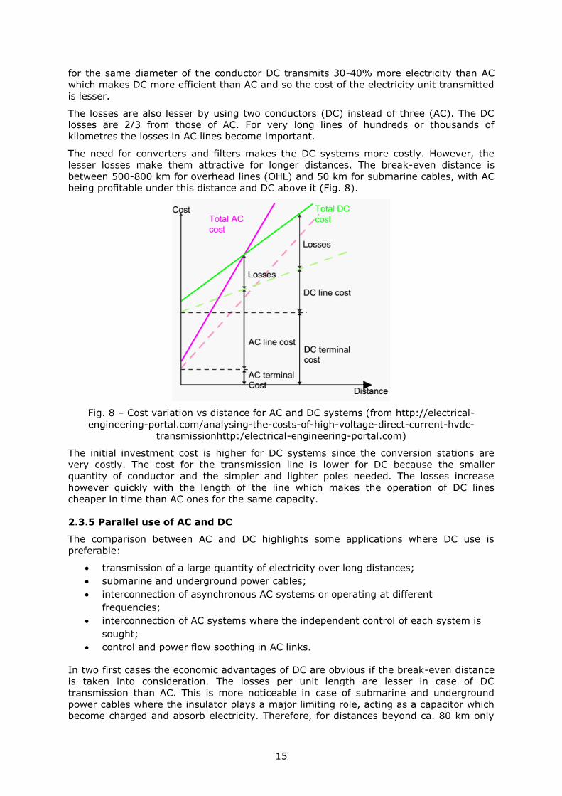
lesser losses make them attractive for longer distances. The break-even distance is
between 500-800 km for overhead lines (OHL) and 50 km for submarine cables, with AC
being profitable under this distance and DC above it (Fig. 8).
Fig. 8 – Cost variation vs distance for AC and DC systems (from http://electrical-
engineering-portal.com/analysing-the-costs-of-high-voltage-direct-current-hvdc-
transmissionhttp:/electrical-engineering-portal.com)
The initial investment cost is higher for DC systems since the conversion stations are
very costly. The cost for the transmission line is lower for DC because the smaller
quantity of conductor and the simpler and lighter poles needed. The losses increase
however quickly with the length of the line which makes the operation of DC lines
cheaper in time than AC ones for the same capacity.
2.3.5 Parallel use of AC and DC
The comparison between AC and DC highlights some applications where DC use is
preferable:
transmission of a large quantity of electricity over long distances;
submarine and underground power cables;
interconnection of asynchronous AC systems or operating at different
frequencies;
interconnection of AC systems where the independent control of each system is
sought;
control and power flow soothing in AC links.
In two first cases the economic advantages of DC are obvious if the break-even distance
is taken into consideration. The losses per unit length are lesser in case of DC
transmission than AC. This is more noticeable in case of submarine and underground
power cables where the insulator plays a major limiting role, acting as a capacitor which
become charged and absorb electricity. Therefore, for distances beyond ca. 80 km only
16
DC technology is used for submarine and underground power cables. The calculated
losses in these cases are ca. 0,9%/100 km and ca. 1,5% in conversion stations (both
taken together).
The superior control capabilities of DC systems make this technology indispensable in
interconnecting AC systems irrespectively of the nature of differences and even when the
distance between them is short as it is the case for the numerous B2B links. The
alternative would be strengthening the AC grids that are in contact.
Under disturbance conditions, the power flows can migrate uncontrolled from a system
to another which can lead to overload and instability and can endanger the system’s
stability. These situations can be avoided or minimized by using and strategically placing
DC links between AC systems.
Although lately the DC technology is more and more used there are no signs that it will
replace the AC one in during the foreseeable future. The impossibility to modify the
voltage is a strong impediment against an utterly use of DC. Also, the DC technology has
impelled the improvement of AC systems performances which makes them rather
complementary than concurrent. DC technology will continue to develop and to become
progressively used for the aforementioned applications.
Under special conditions given by the right-of-way (ROW) restrictions, the AC and DC
lines/wires/conductors can operate in parallel, sometimes on the same pole.
Interferences can emerge, especially from the AC current and voltage superimposition
over the DC but also the other way around. This could lead to the transformer saturation
but it can be avoided by restricting the fundamental frequency current and DC filters
usage. There are also interferences of the ionized fields between the conductors of the
both systems placed on the same pole, when the ionized fields resulted from DC
2.4 HVDC industry
HVDC technology will be much more used in the decades to come to transmit electricity.
This will happen not only because of the advantages offered by the higher capacity,
lesser losses or enhanced and finer control of the DC systems in comparison with AC
ones, but also because more and more power generating sources which will enter in
operation are located at long distances from the consumption centres. This trend is
already visible now in China and Brazil where the HVDC projects are usually linked to
high power hydropower plants and in Europe where they serve the transmission of
offshore wind-produced electricity to the shore.
2.4.1 HVDC equipment manufacturers
The first companies that made the leap from experimental work to major commercial
projects were the ones in Europe. It is worth mentioning here the Swedish electric
company ASEA which installed in 1954 the first HVDC monopolar link between the island
of Gotland and mainland as a submarine cable. This event could be considered the act of
birth of commercial HVDC technology. There were previous tries and experiments as the
line and system produced by Siemens and AEG in 1940s in Germany which was
subsequently dismantled and transported to former USSR and installed there. ASEA was
the main HVDC equipment producer in the world and a pioneer in technology innovation
and development. It still continues to be a big player in HVDC projects worldwide but
after 1988 under the name of ABB, when ASEA merged the Swiss company Brown,
Boveri & Cie (BBC). ABB is the world’s largest builder of electricity grids in general. Since
its formation it executed more than 50 HVDC interconnections worldwide alone or in
collaboration. It contributes to HVDC systems with transformers, switchgear, circuit
breakers and converters but it also offers turnkey projects. ABB has hundreds of
factories around the world and is present in more than 100 countries with offices and
contact points. ABB established R&D centres and equipment factories in China, both in
Chongqing, one producing electric transformers.
17
Siemens is another big name in the industry which started its HVDC operations in 1980s
but only after 2000 has seen a wider involvement in projects worldwide. It started first
with projects in collaboration with other companies in North America, Asia and Europe
while later on it provided the converter parts for a high number of submarine
interconnections in Europe. It has been involved in more than 40 HVDC projects
worldwide.
During the last decade the China Electric Power Research Institute (C-EPRI) has
been developing HVDC technology and designed and assisted building numerous HVDC
systems in China. Since 2014 the institute has been fully reorganized and it has given
the task to design and build the HVDC grid of the country. It is a subsidiary of the
national transmission system operator State Grid Corporation of China. It has been
involved in more than 25 major HVDC projects and it is still involved in designing and
building of more than a dozen of similar or bigger projects in China. The company has
also ambitions to bid for overseas HVDC projects as the latest proposal for the Brazilian
Monte Hydropower UHV Transmission.
Over the years and regionally other electric equipment producing companies developed
or have been involved in HVDC projects. In the last years Alstom/General Electric
(GE) is involved in several HVDC projects in Asia and Europe. Locally, a consortium
composed by Hitachi and Toshiba built the two HVDC interconnections lines and the
four B2B stations in Japan. The HVDC interconnections in India were partly designed and
built by the Indian company Bharat Heavy Electricals (BHEL).
The field of submarine and underground cables for HVDC uses is dominated by
Prysmian and Nexans which contributed to most of the HVDC interconnections of the
kind.
2.4.2 HVDC interconnection operators
There are various arrangements to manage and operate an HVDC system. In the past
these systems were built by the integrated transmission system operators of the
concerned countries and belonged to them. Lately, private entities initiate the
construction of such systems which is usually the case in USA.
Depending largely on the country and on the (general) economic system or on the
energy regulations the entities managing and operating an HVDC system could run from
fully state owned (as in China) to fully private ones (as in USA). In USA the practice is
that a subsidiary of the regional grid operator is purposely created to take care of the
operational role of the HVDC link.
When the HVDC system is found in only one country, which is the case for most of them,
the operator is usually one entity which can be the state-owned TSO or private TSO, or a
subsidiary of it. In the case of international interconnections, as is usually the case in
Europe, the two sides’ TSOs contribute and form a dedicated entity to manage and
operate the HVDC link. Their shares are usually 50-50% but that can vary. At the
moment State Grid Corporation of China is the owner and operator of the highest
number of HVDC systems in the world.
At the moment there are only four HVDC multi-terminal systems in the world: SAPEI in
Italy-France, Pacific Intertie in USA, Hydro Quebec – New England in Canada and
Zhoushan in China but only one (SAPEI) spreads over the territory of two states. In all
cases the system is owned, managed and operated by only one entity – the national TSO
in case of Italy-France, China and Canada and a municipal department in case of USA.
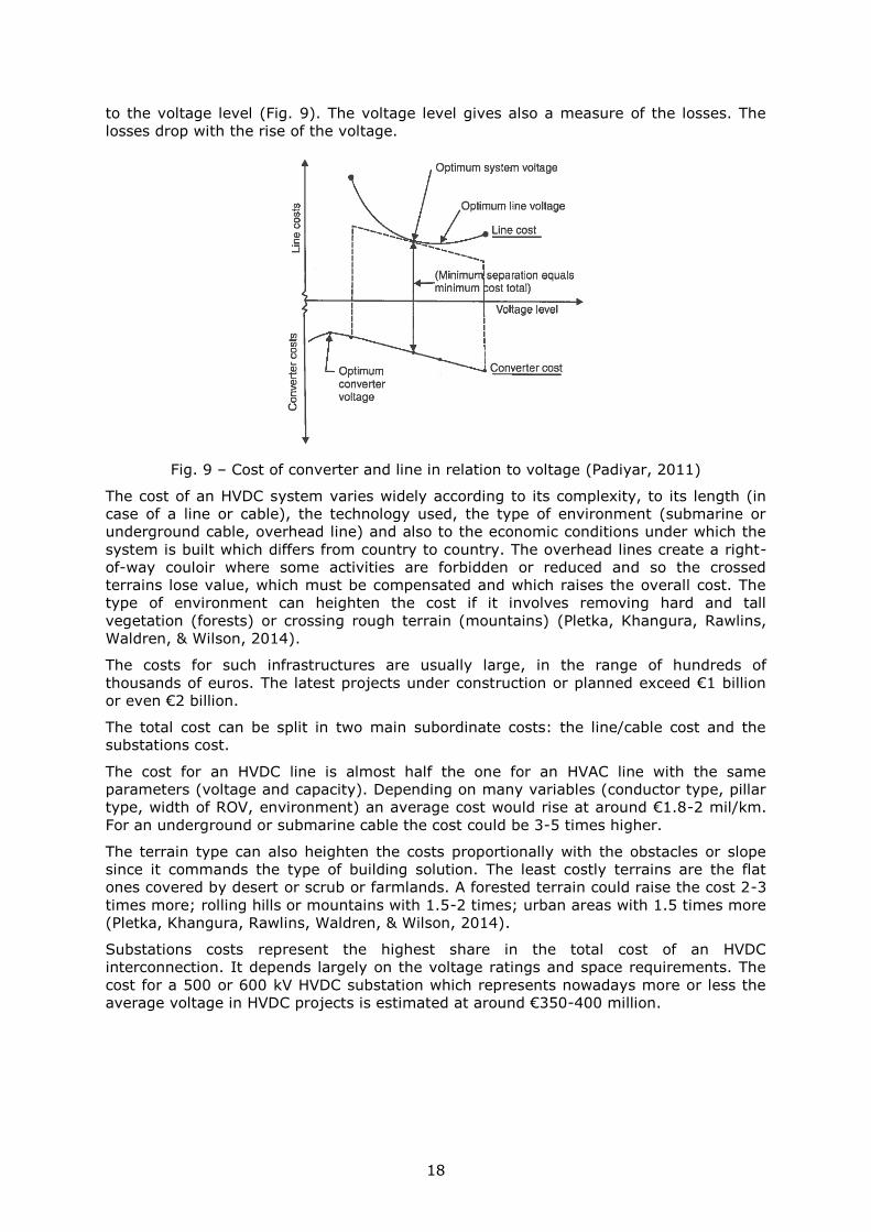
2.4.3 The cost of HVDC infrastructure
The use of DC technology is chosen when the advantages exceed the drawbacks in
comparison especially with AC. Simplifying, one can say the cost of a DC link consists of
the cost of the line and the cost of the converter station(s) which can be both reported
18
to the voltage level (Fig. 9). The voltage level gives also a measure of the losses. The
losses drop with the rise of the voltage.
Fig. 9 – Cost of converter and line in relation to voltage (Padiyar, 2011)
The cost of an HVDC system varies widely according to its complexity, to its length (in
case of a line or cable), the technology used, the type of environment (submarine or
underground cable, overhead line) and also to the economic conditions under which the
system is built which differs from country to country. The overhead lines create a right-
of-way couloir where some activities are forbidden or reduced and so the crossed
terrains lose value, which must be compensated and which raises the overall cost. The
type of environment can heighten the cost if it involves removing hard and tall
vegetation (forests) or crossing rough terrain (mountains) (Pletka, Khangura, Rawlins,
Waldren, & Wilson, 2014).
The costs for such infrastructures are usually large, in the range of hundreds of
thousands of euros. The latest projects under construction or planned exceed €1 billion
or even €2 billion.
The total cost can be split in two main subordinate costs: the line/cable cost and the
substations cost.
The cost for an HVDC line is almost half the one for an HVAC line with the same
parameters (voltage and capacity). Depending on many variables (conductor type, pillar
type, width of ROV, environment) an average cost would rise at around €1.8-2 mil/km.
For an underground or submarine cable the cost could be 3-5 times higher.
The terrain type can also heighten the costs proportionally with the obstacles or slope
since it commands the type of building solution. The least costly terrains are the flat
ones covered by desert or scrub or farmlands. A forested terrain could raise the cost 2-3
times more; rolling hills or mountains with 1.5-2 times; urban areas with 1.5 times more
(Pletka, Khangura, Rawlins, Waldren, & Wilson, 2014).
Substations costs represent the highest share in the total cost of an HVDC
interconnection. It depends largely on the voltage ratings and space requirements. The
cost for a 500 or 600 kV HVDC substation which represents nowadays more or less the
average voltage in HVDC projects is estimated at around €350-400 million.
19
3 Central Asian countries
3.1 Afghanistan
Geographical traits
Afghanistan is a predominantly mountainous country with an arid or semi-arid climate,
landlocked, generally lacking resources which would enormously benefit of an access to
a main power thoroughfare. The country is crossed along a SW-NE direction by a
mountain chain bearing different names (Paropamisus, Koh-i-Baba and Hindukush) and
which represents the state core of Afghanistan. The peripheral northern and southern
zones delimited by this mountainous core are arid and sparsely populated except the
lower area along Amu Daria River in north where a series of towns and villages are
located at places where its tributaries leave the mountains before losing their water into
the arid area. Even the mountainous area is rather semi-arid the rainfall being
insufficient to maintain forested vegetation, the ridges being covered with pastures. Only
the bottom of the valleys is populated and cultivated based on rivers’ water. The
multitude of valleys and ridges with different orientations makes the communication
extremely difficult between the different parts of the country which remain in part
isolated linked by few modest roads.
The southern part is dominated by Dasht-i-Margo Desert crossed for more than 400 km
by the Helmand River after it leaves the mountainous area. It loses gradually its water
during and most of the years it doesn’t manage to reach the endoreic basin of Lake
Sistan, its base level. The slope is gentle in these medium altitude plateaus. The area is
arid with a high solar potential. Besides this high solar potential the Helmand area is also
prized for its rich mineral resources supposed to be present in high quantities and
concentrations, especially copper and iron. Besides these, large quantities of niobium,
cobalt, gold and molybdenum are thought to exist there. The value of all exploitable
mineral resources in the whole country is estimated at around USD 1 trillion (Riesen,
2010). The area is at the present controlled by the Taliban. The perspective to exploit
these mineral resources brings into discussion the supplying with electricity of these
activities which would ensure a high and constant consumption.
The ethnic diversity and the strategic position of the country as a pivot in a
geographically dominant area made the country to be, during the last decades, subject
to prolonged conflicts in order to control it. In such conditions, investments in any form
of infrastructure have been sporadic and inconsistent. Due to conflicts large regions of
the country are unsafe, with stagnant and backward economy but a possible future
exploitation of the mineral resources would reverse the present situation.
Power generation and consumption
The (at least) apparent lacks of energy resources as well as the conflicts which grounded
the country for the last 35 years make the energy sector to be under developed,
incapable to constitute a premise for the country development. The long war years
brought the intentional or collateral destruction of a great part of the generation or
transmission infrastructure without subsequent investments for replacements, repairing,
modernization or expansion (Malik, 2011). These premises make that only slightly more
than a third of the country’s population to have access to electricity. Even in the capital,
Kabul, only 70% of the population is 24 hours continuously supplied with electricity. The
households’ consumption forms the largest percentage from the total while the industry,
services and agriculture contributing with less than a third.
The bad state of the transmission and distribution grids, the oldness of the generators
and the line overloading due to the high demand compared with production make that
the failures and blackouts to be frequent and un-programmed.
The country has 300 MW installed while the demand climbs at 2000 MW. Approx. 1000
MW are imported from the neighbours. The generation, transmission and distribution are
20
operated by Da Afghanistan Breshna Sherkat (DABS), under the control of Energy and
Water Ministry.
Hydro energy contributes with more than 80% to the total installed capacity and to the
total electricity production the rest being covered by thermal plants (gas) and solar.
Most of the hydro power plants have been built between 1950 and 1980. Many of them
have seen their capacity dwindled due to degradation, turbines disposal without the
necessary replacement or renovation. During the last years only one hydro power plant
has been built, in the west, with a rather modest capacity (42 MW), of a mostly local
importance. Most of the hydro power plants are located on the largest rivers in the
mountainous area in east of the country. The country’s hydropower potential is
estimated at 23 GW (Ghalib, 2017).
Natural gas is the main natural resource exploited in Afghanistan and exported toward
Uzbekistan via a pipeline. However, there is only one 35 years old gas-fired power plant,
in Kabul with a rather modest capacity (42 MW).
Given the rough landscape which forms a serious barrier against an easy building of a
unitary power grid (potentiated by the long conflicts), a (at least intermediary) solution
would be the establishment of the local isolated grids, served by small capacity
generators. This has already started to happen through the use of micro-hydro power
plants and diesel generators which serve locally and through the use of the PV panels by
the families/households.
The power grid
The country’s transmission power grid is underdeveloped and serves just a fraction of
population. Large parts of the country are not reached by the transmission power grid
the electricity being produced locally and distributed through small isolated local grids.
In fact there is no unitary power grid but four regional grids isolated from each other.
Afghanistan’s rugged landscape poses serious problems of movement and
communication among different regions of the country. Building a power transmission
infrastructure requires a series of physical barriers to be overcome which is costly to
achieve even for political and economic stable countries (e.g. Tajikistan, a similar
country in terms of physical environment is still not able to serve all its regions with the
national power grid and has to rely regionally on its neighbours’ imports).
Afghanistan interconnected its power grid with the one of Uzbekistan during the last
decade through a 220 kV line and 300 MW capacity which covers a large part of Kabul’s
consumption. This is also the only high voltage line in the country serving its northern
region. An isolated local 110 kV grid exists around Kandahar in the south. The western
area centred on Herat is served by extensions of the Iranian and Turkmen grids.
The losses in the network (technical and commercial) reach 45%. This high figure is due
to the bad state of the transmission and distribution grid but also to the lax regulations
regarding the control and connection to the grid which are insufficiently imposed.
The development plans include the realization of a ring-shaped grid of 220 kV to connect
the most important urban areas of Afghanistan and from which upshots emerge to more
populous and higher consumption zones.
Regionally a series of projects (CASA-1000, TAP) propose the integration of the
neighbouring countries (Turkmenistan, Kyrgyzstan, Tajikistan, Afghanistan and Pakistan)
through several high voltage (500 kV) and high capacity lines (Ghalib, 2017) (FICHTNER
GmbH & Co. KG, 2013) by which the electricity produced by Kyrgyzstan, Tajikistan and
Turkmenistan is shied to and consumed by Afghanistan and Pakistan. The plans include
also building a 1000 kV HVDC line to cross the country.
21
3.2 Azerbaijan
Geographical traits
It is the easternmost country from the Transcaucasia group and has access to the
Caspian Sea. Its territory is wedged between Greater Caucasus Mountains in north and
Lesser Caucasus Mountains in south. Between the two mountain chains the valley of
Kura and the homonym plain is located. Kura reaches the Caspian Sea south the capital,
Baku. In its lower sector the valley opens widely turning into a plain. In its western
upper sector although narrower the valley is still wide enough to act as an important
communication channel with the west followed numerous roads, railroads and pipelines.
The mountain climate ensures a year round river flow. The high hydropower potential is
partly used.
The country holds important hydrocarbon resources, especially in the Caspian Sea, which
are intensively exploited, the country being an important exporter.
The ethnical and confessional mosaic in the region gave birth to tensions which led to
open conflicts. Both Azerbaijan and its neighbour Armenia claim territories from each
other. The western mountainous part of the country is inhabited by Armenian ethnics –
Nagorno Karabakh which has autonomous status inside Azerbaijan. It is however claimed
by Armenia whose army controls the region. The conflict is presently frozen with
periodical isolated escalations.
Power generation and consumption
The generation, transmission, distribution and wholesale of electricity in Azerbaijan are
controlled by the state-run company Azerenerji which holds the monopoly in this this
domain.
Due to the rich gas reserves and the favourable topography and hydrography the
installed generation capacity reflects these resources. More than 80% from the total
installed capacity of 7 GW is found in thermal power plants, the rest goes to hydro. With
all these, 94% of the electricity produced comes from thermal power plants and the rest
6% from hydro. Most of the hydropower plants are located in the west of the country,
including Nahicevan exclave, while the gas-fired power plants tend to group in the east.
The country is able to cover its own consumption and even export electricity to Russia,
Turkey and Georgia. The main consumer is the industry (60%) along with the service
sector (Energy Charter Secretariat, 2011). Almost all households have access to
electricity which is delivered under an acceptable quality. The industry is foreseen to be
the future engine of the consumption increase.
The generation capacity is undergoing a modernization process during the last years
which will increase the plants efficiency. The abundance of gas and oil reserves orients
and plans the future generation capacities which will be built mostly as thermal units.
The plans for building RES capacities (wind and solar) are rather minor (400 MW) in
comparison with the total capacity (Fichtner, 2013).
The power grid
The transmission and distribution grids are operated by Azerenerji which holds the
monopoly on the electricity market. The distribution in Baku and around is ensured by
Baku Electric Grid JSC. The grid is well represented both at the transmission (10000 km)
and distribution level, uniformly covering all the regions of the country (Fig. 10). The
frame of the grid is formed by the 220 and 330 kV lines and by a 500 kV line (Fichtner,
2013).
22
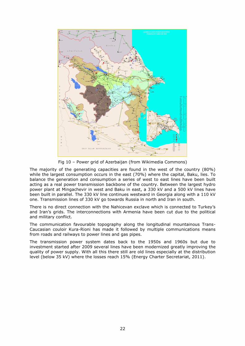
Fig 10 – Power grid of Azerbaijan (from Wikimedia Commons)
The majority of the generating capacities are found in the west of the country (80%)
while the largest consumption occurs in the east (70%) where the capital, Baku, lies. To
balance the generation and consumption a series of west to east lines have been built
acting as a real power transmission backbone of the country. Between the largest hydro
power plant at Mingachevir in west and Baku in east, a 330 kV and a 500 kV lines have
been built in parallel. The 330 kV line continues westward in Georgia along with a 110 kV
one. Transmission lines of 330 kV go towards Russia in north and Iran in south.
There is no direct connection with the Nahicevan exclave which is connected to Turkey’s
and Iran’s grids. The interconnections with Armenia have been cut due to the political
and military conflict.
The communication favourable topography along the longitudinal mountainous Trans-
Caucasian couloir Kura-Rioni has made it followed by multiple communications means
from roads and railways to power lines and gas pipes.
The transmission power system dates back to the 1950s and 1960s but due to
investment started after 2009 several lines have been modernized greatly improving the
quality of power supply. With all this there still are old lines especially at the distribution
level (below 35 kV) where the losses reach 15% (Energy Charter Secretariat, 2011).
23
3.3 China
Geographical traits
China covers a huge area of more than 9,5 mil km2 (3rd place in the world) occupying the
eastern part of the Euro-Asian continental block with a large access to the bordering
seas of the Western Pacific Ocean (Yellow Sea, East China Sea, South China Sea). It is in
the meantime the most populous country in the world with more than 1,4 billion
inhabitants experiencing during the last two decades an accentuated economic growth.
The country’s large area offers a generous variety of landscapes but one can distinguish
the eastern part of the country superimposed over the Great Chinese Plain built by the
sediments carried by the two great rivers that cross it: Huang He and Yangtze and the
western part, generally mountainous or covered by arid plateaus. Most of the population
flocks within the eastern part with one of the highest densities in the world. The western
part is much sparsely inhabited but possessing rich energy resources (hydro, solar,
wind), fuel (coal, oil, gas) or mineral (metals).
In our approach we will tackle mostly the western part where most of the resources are
located and which may present interest for a HVDC line to Europe. There are two regions
in this respect which hold special interest: the north-west mainly overlaid by the
autonomous province of Xingjian and the central-south covered by Yunnan and Sichuan
provinces.
The north-west area, mainly identified with the province of Xinjiang, consists of an
alternation of plateaus mostly arid, traversed in their central part by the Tian Shan
Mountains with its ridges oriented east-west reaching heights of 7400 m. The southern
part is occupied by the Tarim Depression host for the Taklimakan Desert while the
northern part holds the Dzungaria Basin. Tarim Depression is closed around by tall
mountains except on the eastern side where there is a large opening towards the
eastern plateaus. Its fortress configuration, along with the arid climate and lack of
vegetation has discouraged the population settlements. The few settlements found are
located at the border with the mountains ridges where the rivers still hold water before it
is lost in the desert. The weak economic activity as well as the difficulty of “getting out”
from the depression renders this area into one to be avoided for HVDC infrastructure
building.
Not the same thing can be said about the northern compartment covered by Dzungaria
Basin. Although the climate is rather arid the region is widely open to the east and to
the west through a series of “gates” insinuated through the mountain ridges which were
used as migratory routes since ancient times. Among these the most important one is
the Dzungarian Gate which is nowadays used as the main communication link between
China and Kazakhstan.
The zone is overlaid, as mentioned before, by the Autonomous Region of Xinjiang
Uyghur, populated by approx. 22 mil inhabitants, half of them Uyghur. During the last
decades the ethnic proportion dramatically changed with the arrival in great number of
the Chinese Han ethnics to fill the jobs created especially in the mining industry and
government. Locally there is an underground movement to promote the region’s
independence backed by the Uyghur ethnics.
Power generation and consumption
China is the second economy in the world with a steady growth rate which only lately
softened. The electricity demand is also among the highest in the world growing in
average with 2,5-3% annually. The size of the economy and its growth made China to be
since 2011 the first electricity producer in the world, reaching in 2016 a production of 6
TWh. The installed generation capacity sums 1505 GW and the peak load exceeds 650
GW.
24
Following the 2002 energy reform the generation, transmission and distribution are
unbundled with new and different companies taking care of each domain. The generation
is covered by five such companies.
A large part of the electricity (66%) is produced in thermal power plants running on coal
but during the last years the share of renewable generation has greatly increased. China
is also the home for one of the largest hydro power plants in the world: Three Gorges
Dam on Yangtze River with 22500 MW, the largest in the world (the next one by capacity
is Itaipú Dam between Brazil and Paraguay with 14000 MW), Xiluodu on the middle
course of Yangtze River with 13860 MW and three more plants with capacities over 5800
MW (Xiangjiaba, Longtan and Nuozhadu Dam), all of them on rivers in the southern part
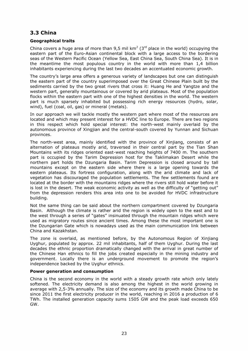
of the country. Besides hydro power plants China plans to build new nuclear reactors
especially in the eastern coastal zones close to the big load centres avoiding such the
long transmission. In order to cope with the growing demand several nuclear reactors
are planned to be built close to the urban centres in interior China, many along the
Yangtze River (Fig. 11). More nuclear power plants mean a reduced need for (HVDC)
long transmission lines.
Fig. 11 – Nuclear plants in China (Source: http://www.jsm.or.jp/)
The country is rich in energy sources and a sizeable part is already brought into use but
an even larger potential both in conventional fossil sources (coal – Fig. 12) as well as in
renewable sources (hydro – Fig. 13, solar, wind) is still waiting for exploitation. The main
problem that China faces is a geographical mismatch between the location of the
resources and of the load centres which is very much amplified by the size of the
country. Building a power transmission or transportation infrastructure requires a
substantial effort. The distance between the energy base and the consumption centres
measures 800-3500 km.
25
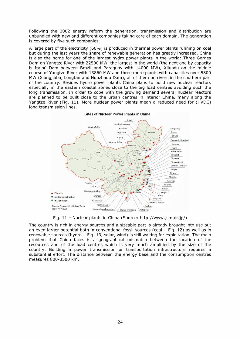
Fig. 12 – Coal reserves in China (Liu Z. , 2015)
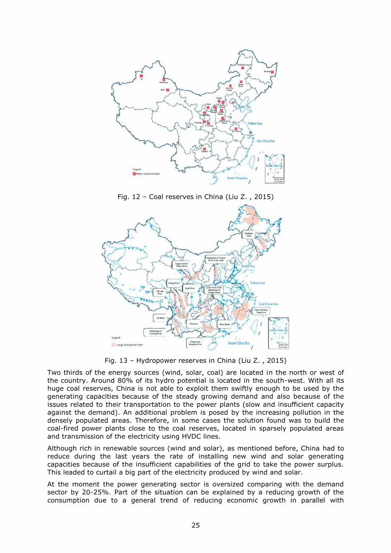
Fig. 13 – Hydropower reserves in China (Liu Z. , 2015)
Two thirds of the energy sources (wind, solar, coal) are located in the north or west of
the country. Around 80% of its hydro potential is located in the south-west. With all its
huge coal reserves, China is not able to exploit them swiftly enough to be used by the
generating capacities because of the steady growing demand and also because of the
issues related to their transportation to the power plants (slow and insufficient capacity
against the demand). An additional problem is posed by the increasing pollution in the
densely populated areas. Therefore, in some cases the solution found was to build the
coal-fired power plants close to the coal reserves, located in sparsely populated areas
and transmission of the electricity using HVDC lines.
Although rich in renewable sources (wind and solar), as mentioned before, China had to
reduce during the last years the rate of installing new wind and solar generating
capacities because of the insufficient capabilities of the grid to take the power surplus.
This leaded to curtail a big part of the electricity produced by wind and solar.
At the moment the power generating sector is oversized comparing with the demand
sector by 20-25%. Part of the situation can be explained by a reducing growth of the
consumption due to a general trend of reducing economic growth in parallel with
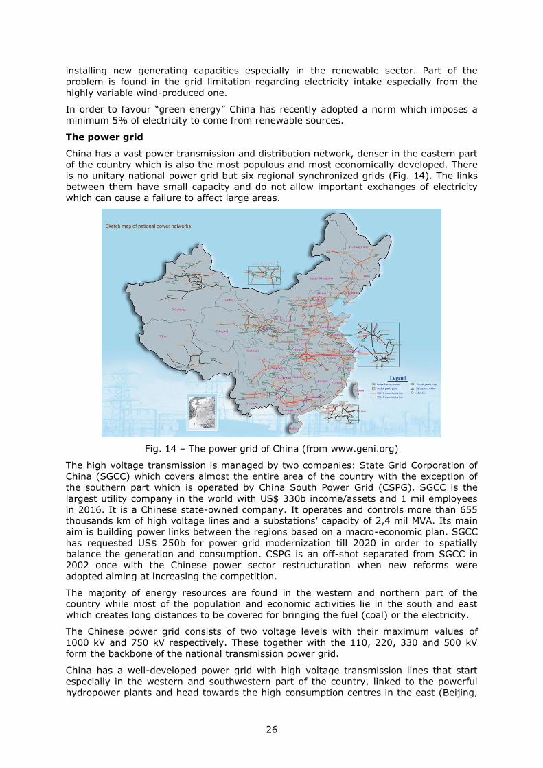
26
installing new generating capacities especially in the renewable sector. Part of the
problem is found in the grid limitation regarding electricity intake especially from the
highly variable wind-produced one.
In order to favour “green energy” China has recently adopted a norm which imposes a
minimum 5% of electricity to come from renewable sources.
The power grid
China has a vast power transmission and distribution network, denser in the eastern part
of the country which is also the most populous and most economically developed. There
is no unitary national power grid but six regional synchronized grids (Fig. 14). The links
between them have small capacity and do not allow important exchanges of electricity
which can cause a failure to affect large areas.
Fig. 14 – The power grid of China (from www.geni.org)
The high voltage transmission is managed by two companies: State Grid Corporation of
China (SGCC) which covers almost the entire area of the country with the exception of
the southern part which is operated by China South Power Grid (CSPG). SGCC is the
largest utility company in the world with US$ 330b income/assets and 1 mil employees
in 2016. It is a Chinese state-owned company. It operates and controls more than 655
thousands km of high voltage lines and a substations’ capacity of 2,4 mil MVA. Its main
aim is building power links between the regions based on a macro-economic plan. SGCC
has requested US$ 250b for power grid modernization till 2020 in order to spatially
balance the generation and consumption. CSPG is an off-shot separated from SGCC in
2002 once with the Chinese power sector restructuration when new reforms were
adopted aiming at increasing the competition.
The majority of energy resources are found in the western and northern part of the
country while most of the population and economic activities lie in the south and east
which creates long distances to be covered for bringing the fuel (coal) or the electricity.
The Chinese power grid consists of two voltage levels with their maximum values of
1000 kV and 750 kV respectively. These together with the 110, 220, 330 and 500 kV
form the backbone of the national transmission power grid.
China has a well-developed power grid with high voltage transmission lines that start
especially in the western and southwestern part of the country, linked to the powerful
hydropower plants and head towards the high consumption centres in the east (Beijing,
27
Shanghai) or south (Hong Kong, Guangzhou). A major issue the country confronts is the
dropping voltage along the lengthy lines. During the last years given the long distances
that separate the generators from the consumption centres (1200-2000 km) the HVAC
power grid is supplemented by a set of HVDC lines of 500 and 800 kV capable of
transmitting 6400 MW or more (Liu Z. , Electric power and energy in China, 2013), (Liu
Z. , 2015). These are among the longest and most powerful systems in the world.
The completion of the Three Gorges hydropower system in 1990s has impelled the
building of the power grid and opened the door for strengthening the existing links or
building new ones between the regional grids. Nevertheless the power grid is still too
weak to cope with the ever growing demand and newly added generation. With the
currently available line capacities the grid is unable to transmit the entire quantity of
electricity produced. In the northern regions with a high wind capacity lately installed the
curtailment is very high affecting the investment efficiency and profitability. In some
regions the curtailment reached 39% in 2015. For this reason the government halted
issuing new licences for new wind turbines deployment until the power grid will be able
to cope with the electricity produced.
During the following years a series of new high capacity transmission line are foreseen to
be built which will harness the abundant resources in northern and western China. Until
2030 more than 23 point-to-point HVDC systems will operate within the country.
China is also regionally involved in a series of projects aiming at setting up a regional
super grid together with its neighbours Russia, Mongolia, South Korea, North Korea and
Japan by which the wind-produced electricity in Siberia to be shipped and consumed in
load centres like Beijing and Seoul.
28
3.4 Georgia
Geographical traits
It occupies the western part of the Transcaucasia isthmus, offering a somewhat mirrored
image of its eastern neighbour, Azerbaijan: a littoral plain bordering the Black Sea and a
central lowland area wedged between the Greater Caucasus in north and Lesser
Caucasus in south. The middle part of the country, centred on the low-lying couloir Kura-
Rioni, is part of a larger tectonic element which crosses the area from west to east. This
couloir acts as real natural communication thoroughfare not exceeding 700 m altitude
despite the surrounding mountainous areas. The northern and southern mountainous
areas act, through their altitude and massiveness, as barriers against an easy circulation
and communication. They are not traversed by roads, with only few exceptions, the links
with the northern (Russia) and southern (Turkey) neighbours following rather the Black
Sea coast.
The climate is generally humid, with Mediterranean tones in west and continental
nuances in east, which ensures the rivers’ flow all year round and favours a wide spread
of forest.
Most of the country’s population of 3,5 million is concentrated along the Kura’s low
laying couloir where the capital Tbilisi is located, along the coastal plain and along
several valleys in the northern and southern mountains. Slightly over half of it is urban.
The ethnical diversity led to the birth of three administrative units with various degrees
of autonomy on the Georgian territory. Abkhazia, located in north-west along the Black
Sea coast and South Ossetia, on the southern slopes of Greater Caucasus Mountains
have triggered secession movements with Russian support, the regions being at the
moment out of the Tbilisi government control.
Power generation and consumption
The total installed capacity in Georgia is ca. 3700 MW with 75% of it in hydropower
plants. There are more than 70 power plants active in the country. The hydro energy
potential is high taking into account the favourable topography and water resources,
with only around 25% being used (KPMG, 2016).
Virtually the entire population has access to electricity with few exceptions of isolated
households in the mountains.
The country manages to cover its internal consumption and is able to export power to its
neighbours. Recently the HVDC B2B station in Akhaltsikhe of 350 MW has been
inaugurated and put into use.
The power grid
The transmission lines are owned and operated by three companies: JSC Georgian State
Electrosystem (GSE), Energotrans Ltd (a subsidiary of GSE) and JSC Sakrusenergo
(Business Association of Georgia, 2016).
The frame of the power grid is formed by 220 kV lines along with the 500 kV line which
cross the country coming from Azerbaijan and heading westward toward Russia (Fig.
15). The transmission network (110-500 kV) totals more than 6000 km of lines.
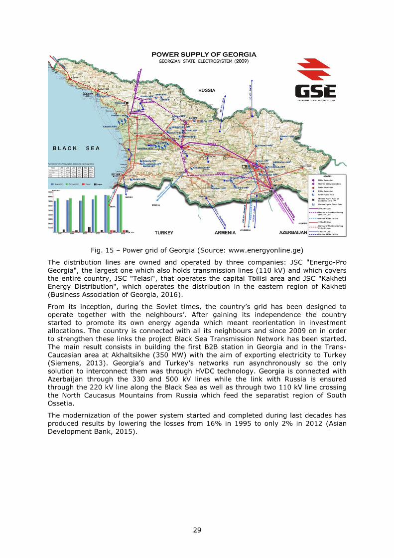
29
Fig. 15 – Power grid of Georgia (Source: www.energyonline.ge)
The distribution lines are owned and operated by three companies: JSC "Energo-Pro
Georgia", the largest one which also holds transmission lines (110 kV) and which covers
the entire country, JSC "Telasi“, that operates the capital Tbilisi area and JSC "Kakheti
Energy Distribution", which operates the distribution in the eastern region of Kakheti
(Business Association of Georgia, 2016).
From its inception, during the Soviet times, the country’s grid has been designed to
operate together with the neighbours’. After gaining its independence the country
started to promote its own energy agenda which meant reorientation in investment
allocations. The country is connected with all its neighbours and since 2009 on in order
to strengthen these links the project Black Sea Transmission Network has been started.
The main result consists in building the first B2B station in Georgia and in the Trans-
Caucasian area at Akhaltsikhe (350 MW) with the aim of exporting electricity to Turkey
(Siemens, 2013). Georgia’s and Turkey’s networks run asynchronously so the only
solution to interconnect them was through HVDC technology. Georgia is connected with
Azerbaijan through the 330 and 500 kV lines while the link with Russia is ensured
through the 220 kV line along the Black Sea as well as through two 110 kV line crossing
the North Caucasus Mountains from Russia which feed the separatist region of South
Ossetia.
The modernization of the power system started and completed during last decades has
produced results by lowering the losses from 16% in 1995 to only 2% in 2012 (Asian
Development Bank, 2015).
30
3.5 India
Geographical traits
India occupies the entire Indian Peninsula and its contact with the Asian block up to the
Himalaya Mountains in north. Is has an area of 3,2 million km2 and a population of over
1,3 billion ranked 2nd in the world with perspectives of becoming number one in years to
come. Most of the peninsular part is covered by a rolling plateau bordered on the sides
by two mountain chains relatively low, stretching along the coasts. The contact with the
continental block is mediated through the Indo-Gangetic Plains oriented west-east built
by Ganges’s and its tributaries sediments. Towards north-west the relief rises gradually
making the link with the upper compartment of the Indus Plain on the Pakistan territory.
At its mouth in Bengal Gulf, Ganges meets Brahmaputra which comes from north-east,
creating a low marshy plain in Bangladesh. Towards north the plain rises slightly through
a series of hills until the Himalaya Mountains replace them in India (north-west
compartment), Nepal (central) and Bhutan (north-east). For our analysis the peninsular
sector does not offer particular importance so we will overlook it, focusing on the
northern compartment.
The Ganges Plain, mentioned before, is among the most productive plains in the world
which made it being inhabited since ancient times, having a high population density,
with tens of large cities (hundreds of thousands inhabitants). Among the most important
cities one can mention the country’s capital – Delhi-New Delhi, Lucknow, Agra, Ludhiana,
Chandigarh, Kanpur, Allahabad, Varanasi and Patna. Its location over a series of low-
lying areas stretching east-west from India in east to Pakistan in west makes it suited for
a HVDC line running from China to Europe. The mountainous border with Myanmar
creates difficulties for such a demarche. Ganges has a rich discharge, with seasonal
fluctuations varying with the monsoon, but its low slope is not favourable to dams or
hydropower plants building. Its left tributaries coming from Himalaya Mountains are
much suited for such works and they are in part exploited.
Ganges Plain is the most populated area in India with the highest densities in the world
(over 500 people /km2). Besides the large number of cities there is also a dense network
of villages doubled by a communication and power transmission network well developed
spatially but outdated. The large number of population along with the economic
development experienced during the last years led to an ever growing electricity demand
a trend which will continue in foreseeable future. Due to its long use the plain is
completely covered by agriculture terrains intensively used with rare patches of natural
vegetation. Finding couloirs for the new ROWs might prove to be difficult. Towards west
the plain continues into the northern compartment of the Indus Plain exhibiting the same
characteristics.
Power generation and consumption
Although it ranks second in the world as population number and it would be expected
that the power generation capacity is the same, India has less than 330 GW installed
which produced 1236 TWh in 2016. This figure ranks India third in the world by
electricity production but its consumption per capita of only 1122 kWh/year places it on
a more modest rank. The electricity access rate generally reaches 99% including the
rural areas but only 80% in the north-eastern states. In many Indian regions the
electricity supply is still inconsistent and numerous failures occur. A big problem is
represented by the theft of electricity. Overall the country has the capacity to regionally
balance the generation and consumption without importing much.
India possesses large coal reserves which stand at its energy base, more than half of its
power installed generation capacity being in coal-fired power plants. Most of the coal
reserves are located in the peninsular central-east area (states of Orissa, Bihar, West
Bengal, Madhya Pradesh, Chhattisgarh) where several high capacity coal-fired power
plants (some more than 2000 MW) have been built. More than half (60%) of the power
generation installed capacity is found in coal-fired power plants. The renewable sources
31
combined contribute with almost 30% to the total installed capacity. The rest is covered
by gas (8%), nuclear (1,8%) and others (General Electricity Authority, 2017).
Wind farms cover 8,5% form the total capacity installed by only 2,5% to the electricity
production, being installed mostly in south and north-west.
The government and the states own most of the generation units and capacity (80%)
while the rest is private.
The power grid
India’s unitary power grid originates in the synchronization of the five almost
independent regional grids. They were connected via B2B links which became obsolete
after synchronization. The power grid is more developed in the north of the country, the
most populous area. Most generators are located in the east while the consumption is
the strongest in the western half and in the south of the peninsula. Therefore the 400 kV
AC grid is supplemented by several 500 and 800 kV HVDC links most of them built
during the last decade. These allow balancing the power between regions and
transmitting large quantities of electricity produced by the high capacity hydro or coal
power plants in east or centre-east to the load centres in west (Delhi) or south
(Bangalore).
Overall India has a rather well developed transmission power grid with few regional
disparities (Fig. 16).
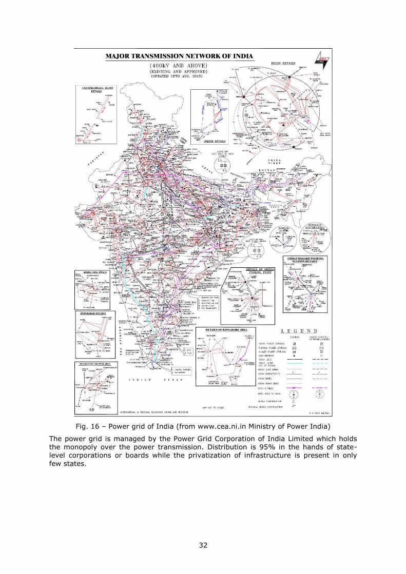
32
Fig. 16 – Power grid of India (from www.cea.ni.in Ministry of Power India)
The power grid is managed by the Power Grid Corporation of India Limited which holds
the monopoly over the power transmission. Distribution is 95% in the hands of state-
level corporations or boards while the privatization of infrastructure is present in only
few states.

33
3.6 Iran
Geographical traits
Iran is a country that fills the entire space between the Caspian Sea in north and the
Arabian Sea in south acting as a link between South Asia and South-West Asia. The
country is predominantly mountainous with few areas occupied by plains. These are
located along the northern Caspian Sea coast and southern Arabian Sea’s and Persian
Gulf’s with the largest plain in the country, a compartment of the Mesopotamian Plain in
Iran. The main mountain chain – Zagros Mountains occupies the western third of the
country stretching NW-SE for more than 2000 km frequently reaching 4000 m altitude.
They are rather an association of ridges fragmented by valleys running in all directions
which breaks their unity and massiveness. They are therefore quite easy to cross despite
their generally high altitude and large area occupied. Locally, relatively large tectonic
basins were formed heavily populated nowadays. Elburz Mountains, a volcanic chain
stretches in the northern part of the country, parallel with the Caspian Plain and coast.
The eastern half of the country is covered by an association of mountain chains and
lower depression areas, usually endoreic, occupied by deserts (Kavir, Lut).
Except for the northern part, along the Caspian Sea, where the climate humid favours
the existence of forests, most of the country is arid or semi-arid including the
mountainous zones. On most of the major rivers there are dams built with multiple use
of the water: hydropower, drinking water, irrigations, flood control.
Most of the country’s population (81 million) is spread across the northern and western
half overlay on Zagros and Elburz Mountains. The eastern half has only a few medium to
large cities. Almost ¾ of the population is urban, the largest cities being the capital,
Tehran (8 million), Mashhad, Isfahan, Shiraz and Tabriz, each with more than 1 million.
Iran has rich mineral resources with oil bringing most of the income. These are
concentrated especially in south-west bordering Iraq.
The arid but sunny areas in the east have a high solar potential which exploited would
produce a large quantity of “clean” electricity.
Power generation and consumption
Iran represents the giant of South-West Asia by its population and area but also by its
industrial output and oil and gas reserves. It is also a medium developed country with a
steady rising GDP that allows and also stimulates a growing electric consumption (3-6%
increase annually). The degree of development can be seen in the share of industry in
the electricity consumption, the same as the households’, both covering about one third.
Virtually 00% of the households and population have access to electricity.
More than 80% of the total installed generation capacity of 75 GW is found in thermal
power plants, most gas-fired (70%) with an average efficiency of 38%. The rest counts
for hydropower plants (14%) and other forms of which the nuclear totals 915 MW. The
RES although growing during the last years, contributes insignificantly to the total (few
tens of MW).
Generally, the Iranian energy sector is based on hydrocarbons which generate high
pollution. The country holds substantial oil and gas reserves and intends to use them in
future which can be seen in the newly installed capacities where 80% of them are in
thermal power plants. The richness in resources makes Iran enjoy a 90% degree of
autonomy in energy sector and make the country a net exporter of electricity.
The main gas fields are located in the south-west along the border with Iraq and along
the Persian Gulf.
With the dwindling oil and gas reserves perspective the country plans to extend its
nuclear capacity to 20000 MW in 2025.
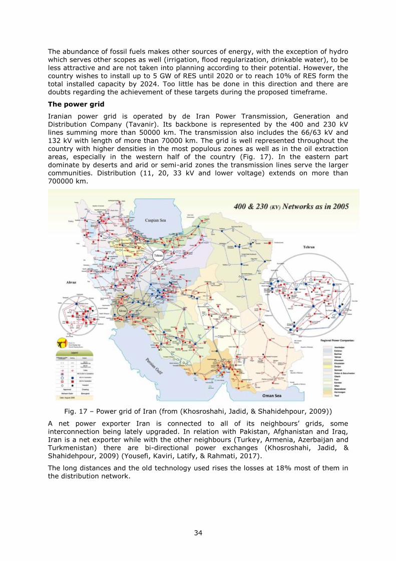
34
The abundance of fossil fuels makes other sources of energy, with the exception of hydro
which serves other scopes as well (irrigation, flood regularization, drinkable water), to be
less attractive and are not taken into planning according to their potential. However, the
country wishes to install up to 5 GW of RES until 2020 or to reach 10% of RES form the
total installed capacity by 2024. Too little has be done in this direction and there are
doubts regarding the achievement of these targets during the proposed timeframe.
The power grid
Iranian power grid is operated by de Iran Power Transmission, Generation and
Distribution Company (Tavanir). Its backbone is represented by the 400 and 230 kV
lines summing more than 50000 km. The transmission also includes the 66/63 kV and
132 kV with length of more than 70000 km. The grid is well represented throughout the
country with higher densities in the most populous zones as well as in the oil extraction
areas, especially in the western half of the country (Fig. 17). In the eastern part
dominate by deserts and arid or semi-arid zones the transmission lines serve the larger
communities. Distribution (11, 20, 33 kV and lower voltage) extends on more than
700000 km.
Fig. 17 – Power grid of Iran (from (Khosroshahi, Jadid, & Shahidehpour, 2009))
A net power exporter Iran is connected to all of its neighbours’ grids, some
interconnection being lately upgraded. In relation with Pakistan, Afghanistan and Iraq,
Iran is a net exporter while with the other neighbours (Turkey, Armenia, Azerbaijan and
Turkmenistan) there are bi-directional power exchanges (Khosroshahi, Jadid, &
Shahidehpour, 2009) (Yousefi, Kaviri, Latify, & Rahmati, 2017).
The long distances and the old technology used rises the losses at 18% most of them in
the distribution network.
35
3.7 Kazakhstan
Geographical traits
The country occupies a central position in the western half of continental Asia. It is the
largest Central Asian country by land (2,7 million km2), landlocked between Russia at
north, Uzbekistan, Kyrgyzstan and Turkmenistan at south and China at east. It stretches
3000 km east-west and more than a half of that distance north to south. It has access to
the landlocked Caspian Sea with further connections to Iran, Azerbaijan and Russia. The
country covers a part of an old geological platform with a rather flat landscape over most
of its surface. Altitude rises towards southern and eastern borders where mountains
reach 3000-7000 m creating serious challenges for communications. The northern,
southwestern and western borders are largely open towards adjacent countries without
major barriers. However, the environmental conditions in parts of the country rendered
them inhospitable to population settlement. This is the case for most of the central and
western parts, covered by several deserts (Betpak Dala, Muyunkum, and Kyzylkum). The
population displays a non-homogenous distribution with most of it clustering in south,
close to the permanent flowing rivers from the mountains or in the north, along the
border with Russia, where more rainfall occurs. The central parts of the country contain
a small proportion of its population. Only along the valley of Syr Darya river the
population number is higher than the surrounding steppes. At the border with Uzbekistan
lies the rests of the Aral Lake which continues to shrink due to the constant
desertification tendency.
Most of the territory is covered by a sparse short vegetation realm called steppe or by
deserts which can be sandy or stony. Very few forested areas exists, mainly bordering
the mountain slopes in southwest.
The few rivers that cross the central plateau carry little water and can dry during
summer. They created large and shallow valleys which do not constitute big problems to
communication and engineering works.
Although mountainous, the eastern border shows here and there places with low altitude
and wide enough to be used as communication channels from ancient times. One such a
place is the so-called Dzungarian Gate, a low mountain pass between Central Asia and
China. Its altitude descends to only 450 m from 3000-4500 m of the surrounding
mountain ridges. It is used as an important communication route towards China, being
followed by a highway and a railway.
Most of the country lies within “extreme” continental climate characterized by hot and
dry summers and cold winters. The southern half of the country experiences a cold
desert or semi-arid climate with pockets of Mediterranean continental climate bordering
the mountains. The northern half receives more rainfall turning the climate into a
temperate continental one.
Its population amounts to 18 million with ⅔ Kazakh and almost ¼ Russian. Its density is
one of the lowest among the countries in the area – 7 people/ km2. The spread of
population follows the main bio-climatic zones with most of it concentrated in south on
the watered mountains slopes or in north at the border with Russia. A little bit over half
of the population is urban with the former capital Almaty topping at 1,7 million and the
current capital Astana at 860000 inhabitants. Eight other cities surpass 200000.
The northern cluster of the population is integrated into a wider populous and economic
area which extends beyond the border, in Russia. The communication network and also
the power grid follow rather the developmental pattern established during Soviet era
when internal borders didn’t count too much.
The industry (and power consumption) follows closely the distribution of population.
36
Power generation and consumption
All the data regarding the power balance in Kazakhstan is provided by (KEGOC, 2017).
Kazakhstan had an increase both in power generation and consumption in 2016
compared with 2015. The peak load in 2016 was 13990 MW which increased 5,4%
compared with 2015. The generation capacity increased in 2016 with 6,8% compared
with 2015, reaching 13809 MW.
Most of the electricity (94076 million kWh in 2016) is produced in thermal power plants
(79,4%). The rest is split between hydro (12,3%), gas (7,9%) and wind and solar
(0,4%). The electricity production in 2016 went up 3,6% compared with 2015. Electricity
is produced in almost 70 power plants, most of them located in the north part of the
country close to the coal mines while an important share of the consumption is done in
south. The electricity generation in the west is underprovided and the area has to rely on
imports from Russia to cover its needs (U.S. Department of Commerce, 2016).
The country has the goal of raising its renewable share in the production up to 3% until
2020 and to 10% by 2030.
Although the first place in the World for uranium reserves Kazakhstan doesn’t possess
any active nuclear power plant but plans include building a 1500 MW unit near Lake
Balkash.
The generating capacities have been built and installed during Soviet era or shortly after.
Running for more than 30 years it is estimated that the level of wear attains constantly
70%.
Electricity consumption went also up to 92300 million kWh (1,6% up from 2015). Most of
it is done in north (67%) and south (20,6%) while the west is the smallest contributor
(12,5%). As consumption per capita, at 5100 kWh/year it ranks closely with developed
countries at pair with European Union, although this might include the inefficient and
energetically hungry industries.
The country is also a net exporter of electricity both to Russia (1640,2 million kWh in
2016) and to Kyrgyzstan (124,7 million kWh).
The power grid
The Unified Power System (UPS RK) of Kazakhstan is under the responsibility of the
Kazakhstan Electricity Grid Operating Company (KEGOC) who manages more than
25000 km of lines and 78 power stations with voltages ranging from 0,4 kV to 1150 kV
(KEGOC, 2017). The backbone of the grid is represented by the 220 kV and 500 kV lines
which account for 85% of the length (Fig. 18). The link with Russia in north is ensured
by an 1150 kV line of 1420 km, besides few other 500 kV lines. Most of the lines run in
the eastern half of the country branching away from main arteries. The lines in Western
Kazakhstan, around Caspian Sea, are not connected directly with the rest of the national
grid but the link is assured through Russia, in north, with 220 kV lines.
The power grid operates synchronously with the one of the CIS countries within UPS/IPS.
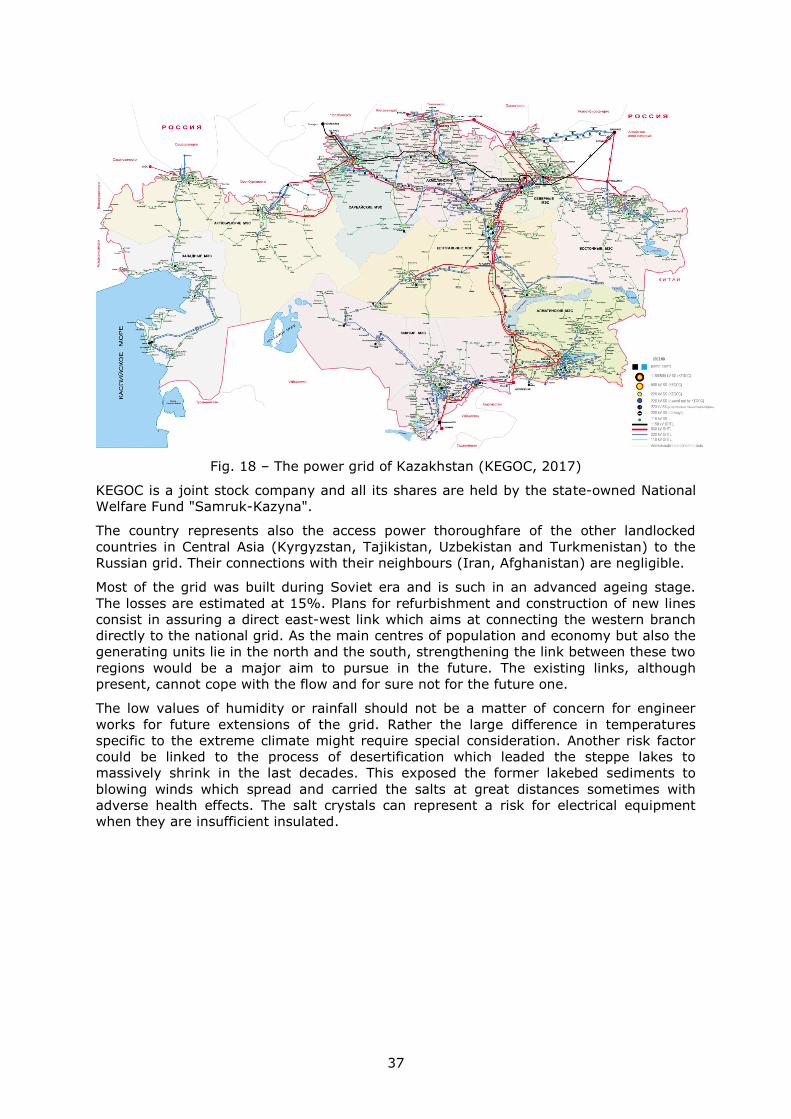
37
Fig. 18 – The power grid of Kazakhstan (KEGOC, 2017)
KEGOC is a joint stock company and all its shares are held by the state-owned National
Welfare Fund "Samruk-Kazyna".
The country represents also the access power thoroughfare of the other landlocked
countries in Central Asia (Kyrgyzstan, Tajikistan, Uzbekistan and Turkmenistan) to the
Russian grid. Their connections with their neighbours (Iran, Afghanistan) are negligible.
Most of the grid was built during Soviet era and is such in an advanced ageing stage.
The losses are estimated at 15%. Plans for refurbishment and construction of new lines
consist in assuring a direct east-west link which aims at connecting the western branch
directly to the national grid. As the main centres of population and economy but also the
generating units lie in the north and the south, strengthening the link between these two
regions would be a major aim to pursue in the future. The existing links, although
present, cannot cope with the flow and for sure not for the future one.
The low values of humidity or rainfall should not be a matter of concern for engineer
works for future extensions of the grid. Rather the large difference in temperatures
specific to the extreme climate might require special consideration. Another risk factor
could be linked to the process of desertification which leaded the steppe lakes to
massively shrink in the last decades. This exposed the former lakebed sediments to
blowing winds which spread and carried the salts at great distances sometimes with
adverse health effects. The salt crystals can represent a risk for electrical equipment
when they are insufficient insulated.
38
3.8 Kyrgyzstan
Geographical traits
Kyrgyzstan is a landlocked country in Central Asia covered by Tian Shan Mountains on
80% of its area. The ridges rising to over 7000 m are covered with snow-caps which
along with the high gradient offer a great hydro power potential only in part exploited.
The only lowland areas (and most populated ones) are few large valleys and the basin of
Issyk-Kul Lake. The river system is tributary to an endorheic area ending in Issyk-Kul
and Aral lakes.
The shape of the country is influenced by a protrusion from its western neighbour
Uzbekistan along the fertile Fergana Valley, heavily populated which has consequences
in communications and infrastructure layout. The almost 6 million inhabitants occupy the
valleys and lower areas with two main clusters: in a more populous northern region
which extends beyond the border in Kazakhstan and which also includes the capital –
Bishkek and in southwest, along Fergana Valley extending in Uzbekistan. These two
regions are split apart by the long, high and rugged Tian Shan Mountains crossed by
roads in only a handful of places.
Despite its large reserves of gold the country is one of the poorest in Central Asia. Most
of the population still makes a living from subsistence agriculture while the industry and
services are poorly developed.
Power generation and consumption
Tian Shan Mountains cover around 80% of Kyrgyzstan area so it has a very large hydro
potential. Although 90% of the electricity is produced from hydro this potential is only
10% developed. Out of 18 power plants present in the country 16 are hydro (2950 MW)
and two thermal (763 MW). Being built in Soviet times they are old and outdated
needing thorough overhaul. A number of projects aiming at exploiting the potential have
been started during Soviet times but never brought to completion. These could represent
important opportunities to export power in future.
The production of electricity amounts approx. 15000 million kWh/year but the high
losses of 30% diminish considerably the part reaching the consumers. Most of the
consumers are residential especially after the decline of industry coming with USSR
disintegration.
Most of the electricity is produced in south but 70% of the consumption occurs in north
so until the completion of the new Datka-Kemin line the production in south was
exported to Uzbekistan while the consumption in north has to be covered by imports
from Kazakhstan. With consumption per capita of 1900 kWh/year it shows a potential
still to be developed in future. The total consumption is around 11000 kWh/ year which
makes the country a net power exporter.
The country has an active power exchange with neighbours mainly needed for system
stability but lately also for meeting the demand in areas domestically underfed.
The power grid
The grid layout of Kyrgyzstan shows a close interconnection with those of Kazakhstan
and Uzbekistan (Fig. 19). Due to the grid configuration which was designed and built
during USSR times, southern Kyrgyzstan supplied electricity to Uzbekistan while the
north had to import power form Kazakhstan. While this arrangement worked well during
the existence of USSR now it hinders the aim of the country in becoming energy
independent.
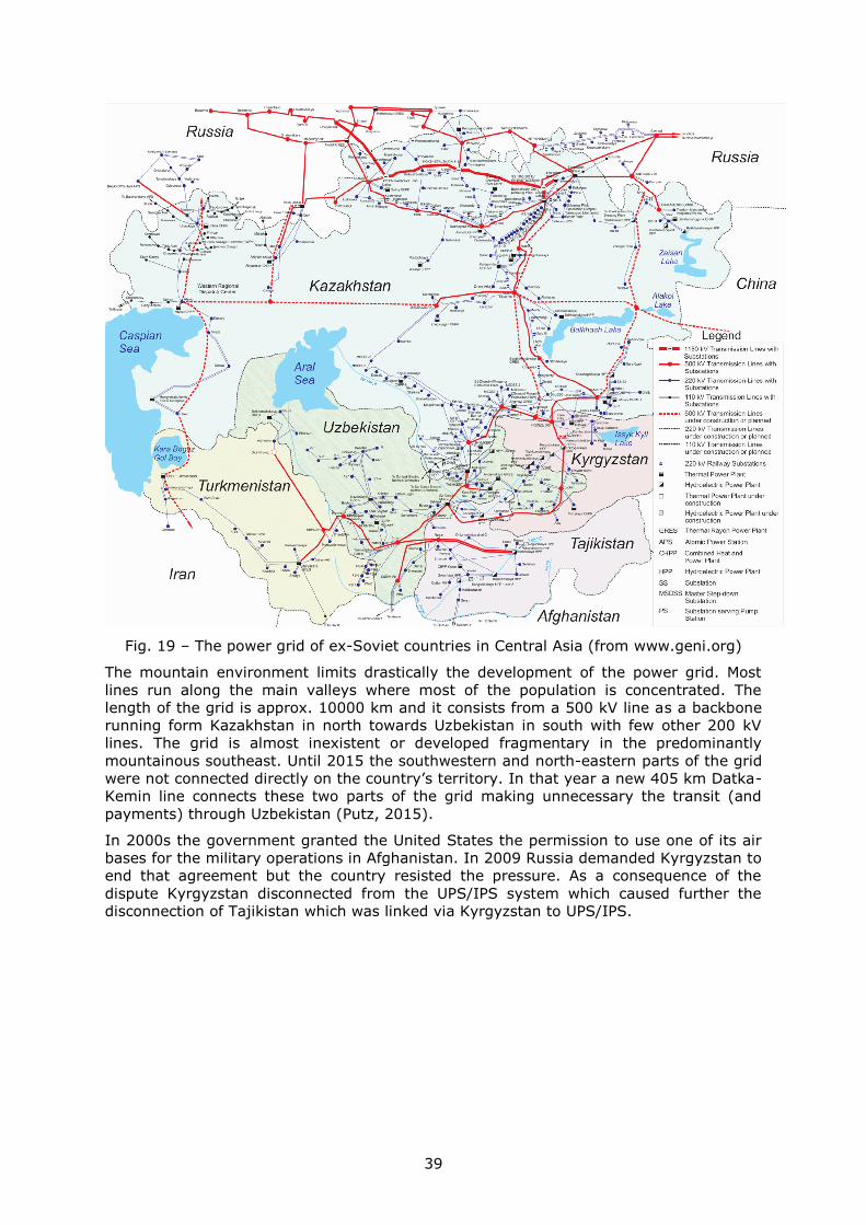
39
Fig. 19 – The power grid of ex-Soviet countries in Central Asia (from www.geni.org)
The mountain environment limits drastically the development of the power grid. Most
lines run along the main valleys where most of the population is concentrated. The
length of the grid is approx. 10000 km and it consists from a 500 kV line as a backbone
running form Kazakhstan in north towards Uzbekistan in south with few other 200 kV
lines. The grid is almost inexistent or developed fragmentary in the predominantly
mountainous southeast. Until 2015 the southwestern and north-eastern parts of the grid
were not connected directly on the country’s territory. In that year a new 405 km Datka-
Kemin line connects these two parts of the grid making unnecessary the transit (and
payments) through Uzbekistan (Putz, 2015).
In 2000s the government granted the United States the permission to use one of its air
bases for the military operations in Afghanistan. In 2009 Russia demanded Kyrgyzstan to
end that agreement but the country resisted the pressure. As a consequence of the
dispute Kyrgyzstan disconnected from the UPS/IPS system which caused further the
disconnection of Tajikistan which was linked via Kyrgyzstan to UPS/IPS.
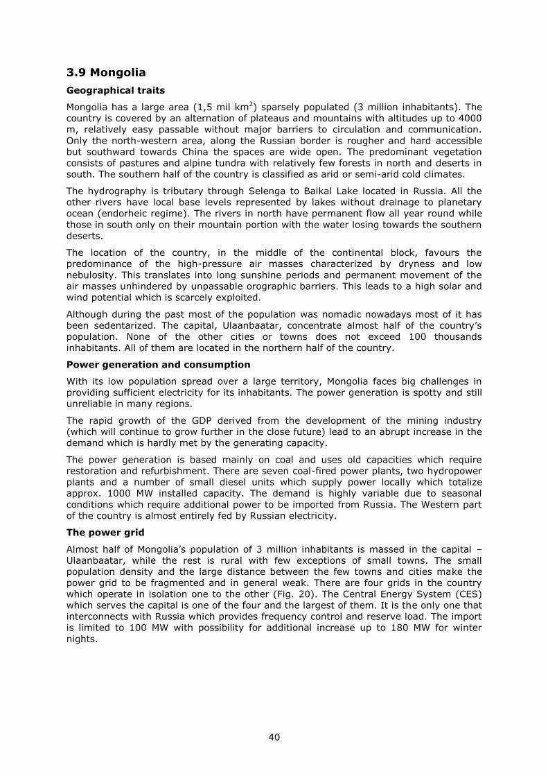
40
3.9 Mongolia
Geographical traits
Mongolia has a large area (1,5 mil km2) sparsely populated (3 million inhabitants). The
country is covered by an alternation of plateaus and mountains with altitudes up to 4000
m, relatively easy passable without major barriers to circulation and communication.
Only the north-western area, along the Russian border is rougher and hard accessible
but southward towards China the spaces are wide open. The predominant vegetation
consists of pastures and alpine tundra with relatively few forests in north and deserts in
south. The southern half of the country is classified as arid or semi-arid cold climates.
The hydrography is tributary through Selenga to Baikal Lake located in Russia. All the
other rivers have local base levels represented by lakes without drainage to planetary
ocean (endorheic regime). The rivers in north have permanent flow all year round while
those in south only on their mountain portion with the water losing towards the southern
deserts.
The location of the country, in the middle of the continental block, favours the
predominance of the high-pressure air masses characterized by dryness and low
nebulosity. This translates into long sunshine periods and permanent movement of the
air masses unhindered by unpassable orographic barriers. This leads to a high solar and
wind potential which is scarcely exploited.
Although during the past most of the population was nomadic nowadays most of it has
been sedentarized. The capital, Ulaanbaatar, concentrate almost half of the country’s
population. None of the other cities or towns does not exceed 100 thousands
inhabitants. All of them are located in the northern half of the country.
Power generation and consumption
With its low population spread over a large territory, Mongolia faces big challenges in
providing sufficient electricity for its inhabitants. The power generation is spotty and still
unreliable in many regions.
The rapid growth of the GDP derived from the development of the mining industry
(which will continue to grow further in the close future) lead to an abrupt increase in the
demand which is hardly met by the generating capacity.
The power generation is based mainly on coal and uses old capacities which require
restoration and refurbishment. There are seven coal-fired power plants, two hydropower
plants and a number of small diesel units which supply power locally which totalize
approx. 1000 MW installed capacity. The demand is highly variable due to seasonal
conditions which require additional power to be imported from Russia. The Western part
of the country is almost entirely fed by Russian electricity.
The power grid
Almost half of Mongolia’s population of 3 million inhabitants is massed in the capital –
Ulaanbaatar, while the rest is rural with few exceptions of small towns. The small
population density and the large distance between the few towns and cities make the
power grid to be fragmented and in general weak. There are four grids in the country
which operate in isolation one to the other (Fig. 20). The Central Energy System (CES)
which serves the capital is one of the four and the largest of them. It is the only one that
interconnects with Russia which provides frequency control and reserve load. The import
is limited to 100 MW with possibility for additional increase up to 180 MW for winter
nights.
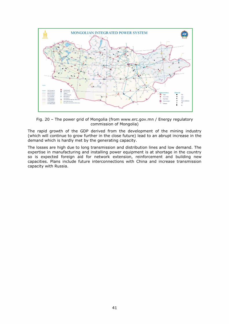
41
Fig. 20 – The power grid of Mongolia (from www.erc.gov.mn / Energy regulatory
commission of Mongolia)
The rapid growth of the GDP derived from the development of the mining industry
(which will continue to grow further in the close future) lead to an abrupt increase in the
demand which is hardly met by the generating capacity.
The losses are high due to long transmission and distribution lines and low demand. The
expertise in manufacturing and installing power equipment is at shortage in the country
so is expected foreign aid for network extension, reinforcement and building new
capacities. Plans include future interconnections with China and increase transmission
capacity with Russia.
42
3.10 Myanmar
Geographical traits
The country occupies an intermediate position between the Asian continental block in
north, the Indian sub-continent in west and the countries of the Indochinese Peninsula in
east, which is reflected both in the physical landscape and in cultural traits of the
population.
The natural units form the shape of an amphitheatre with mountainous regions towards
the western, northern and eastern borders which descend towards the interior where the
valley of Ayeyarwady River and its tributary is located, a truly backbone of the country.
East of Ayeyarwady it is located the second most important river of the country –
Salween, which springs in China, which has a rather marginal position and traverses a
mountainous area having a narrow valley. All the main rivers flow from north to south
which influences the natural elements layout and orients the land populating and
economic flows. The central zone, between Ayeyarwady and Salween includes the core
of the population. The highest population density in the country is recorded here
between the largest city and ancient capital – Yangon in south and Mandalay in north
passing through the present capital – Nay Pyi Taw. The northern and eastern areas as
well as the southern elongation are inhabited by government-hostile ethnic groups.
The few land-based communication routes and the power infrastructure follow the main
valleys north to south oriented with rare ramifications to valorise the peripheral areas
and bring them closer to the core.
The northern part of the country which could be located on a possible HVDC route from
China to India and further to Europe is predominantly mountainous with the rivers
flowing north to south (while the HVDC line would run east-west) and populated by
hostile-government groups. Its links with the core area are weak. These are elements
which lower the attractiveness of the route. The northern region offers however a high
hydropower potential which exploited would bring large quantities of predictable
electricity to the HVDC link.
Power generation and consumption
The country’s power transmission infrastructure is old and minimally maintained which
leads to numerous failures. The generation capacity is reduced and most of the time
does not manage to meet the swiftly growing consumption. Only one third of the
population has access to electricity (Nam, Cham, & Halili, 2015), even if during the last
years the number of consumers has increased. The power supply is not continuous with
numerous failures occurring even in large cities like Yangon or Mandalay, where the
availability might be limited to six hours/day. 75% of the electricity is consumed in the
three largest cities of the country: Yangon (50%), Mandalay (17%) and the capital, Nay
Pyi Taw (6%). Myanmar has the lowest power consumption per capita in South-eastern
Asia countries: slightly over 150 kWh/ year/ capita, less than half of Laos and almost 30
times less than Malaysia, the “champion” of the region.
The consumption is estimated currently at around 4600 MW with a growth of 14%/year.
The majority of the generation capacity (2/3 out of 5200 MW) is installed in hydro power
plants which can be affected seasonally by drought. In December-March the reservoirs
dry which affects the capacity of the generation to meet the demand. During this period
only approx. 500 MW of generation are available but nevertheless 20 more power plants
are planned to be built. Two of them are large capacity: Myitsone (6000 MW) in the
northern state of Kachin which would export the entire production to China and Tasang
(7110 MW) in the eastern state of Shan which would export 25% of the production in
Thailand. Both projects are at the moment on hold. Thousands of people would be
relocated in case of their achievement.
43
A large part of the newly planned installed capacity (12780 MW) would be in 12 coal
power plants. Unfortunately the country doesn’t hold large coal reserves so most of it
would have to be imported which will make the country long term energy dependent.
Currently there are 26 hydro power plants, 27 gas-fired power plants and one coal-fired
power plant running in the country. The majority of them have rather small capacity (on
average 120 MW). More than 570 diesel generators (summing a little more over 100
MW) produce electrify for local use where the national power grid does not reach. The
largest power plants are the Shweli hydro power plant (600 MW) and Yeywa (790 MW)
which went on line in 2008 and 2010.
The country’s hydropower potential sums up 46000 MW, mainly on Ayeyarwady and
Salween rivers.
The large majority of the grid connected power plants are located in the central part of
the country between Yangon in south and Mandalay in north. Most of them are built after
2000, only the gas-fired ones being older (1990s).
Given the lack of investment in economy and infrastructure for a long time in the past
the country experiences at the moment a marked increase in services and manufacturing
output which engages a pronounced power demand. The consumption in 2030 is
estimated at 13000 MW. In order to meet this demand the country plans the
construction of 41 new power plants by that time. The installing rate should be 1,2
GW/year in order to reach that goal but it is actually at only 25% of its which makes
reaching the goal problematic.
Until Myanmar manages to build its own self-covered generating capacity the country
could take advantage of the exporter position of its neighbour Laos which by 2020 will
produce five times more electricity than its needs.
The power grid
The country’s power grid is insufficient developed both technically and spatially. Only
slightly more than a third of the population has access to electricity and only 16%
receive it form the national power grid. The existing 3000 km of 230 kV, 2200 km of 132
kV and 4600 km of 66 kV of transmission lines are insufficient to uniformly cover a
country of such size (676 thousands km2) and population (50 million). This network
covers only the central part of the country between Yangon in south and Mandalay in
north. Vast areas especially the north of the country, peripheral zones along the western
and eastern borders as well as the southern elongation towards the Kra Isthmus lack
elements or links of the national power grid (Fig. 21).
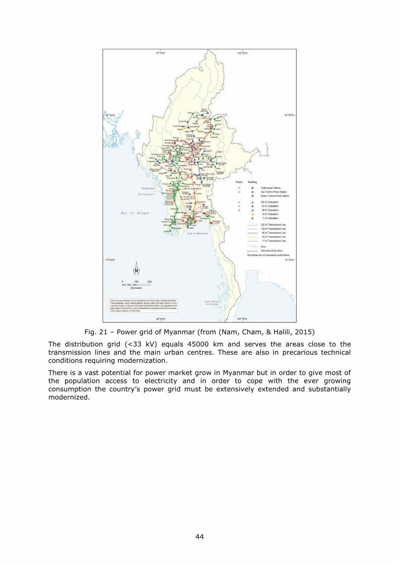
44
Fig. 21 – Power grid of Myanmar (from (Nam, Cham, & Halili, 2015)
The distribution grid (<33 kV) equals 45000 km and serves the areas close to the
transmission lines and the main urban centres. These are also in precarious technical
conditions requiring modernization.
There is a vast potential for power market grow in Myanmar but in order to give most of
the population access to electricity and in order to cope with the ever growing
consumption the country’s power grid must be extensively extended and substantially
modernized.
45
3.11 Pakistan
Geographical traits
Pakistan represents an important country in the region by its population (over 200 mil
inhabitants), area (880 thousands km2) and by its transition role between the Indian
sub-continent and the semi-arid spaces or mountains in south-west Asia.
Geographically the country can be divided in two unequal parts based on altitude. The
dividing line is done by the valley of Indus, a truly backbone of the country. The south-
east part, along the Indian border, is low, traversed by Indus and its tributaries.
Similarly to Ganges Plain, the Indus Plain has been inhabited since ancient times
displaying today high densities. The majority of the country’s population resides here
being the most fertile zone. Only towards the central zone the plain becomes more arid
making room for Thar Desert. Population displays high densities also in Punjab Plain and
on the southern slopes of the mountains. Besides the most populous Indus Valley the
population forms also large centres on the Arabian Sea cost where the largest Pakistan
city lays – Karachi or close by – Hyderabad.
Parts of territories in northern Pakistan are in contention with India. The Muslim-majority
Indian state of Jammu and Kashmir is claimed by Pakistan. Occasional hostilities occur
spottily along the border.
The western and northern parts are mountainous, arid and semi-arid in west. Towards
north the altitude increases reaching 7500 m in Hindu Kush Mountains and over 8000 m
in Karakoram Mountains which are real water towers that ensure a permanent flow on
Indus and its tributaries all year round. The western mountain ridge acts as a strong
barrier against an easy communication. There are a series of mountain passes of which
Khyber Pass is the most accessible one being used by the road linking Pakistan’s capital
Islamabad to Afghanistan’s one Kabul. To the south the Quetta Pass also offers an easier
crossing between the middle parts of the Indus Plain and southern Afghanistan towards
Kandahar or to the western Pakistan region of Baluchistan. The Makran Mountains
located here drastically hinder the building of a power transmission infrastructure. The
north to south valleys and ridges run perpendicular on the east to west direction of a
HVDC line from China to Europe. Conversely, the arid climate holding a great solar
potential could contribute with massive RES to the line.
Power generation and consumption
The electricity is produced and distributed by two power companies: Water and Power
Development Authority (WAPDA) for the whole country and Karachi Electric (K-Electric)
which covers the area of the largest city Karachi. There are also a growing number of
independent producers.
The installed capacity totals 25 GW which generates approx. 100 TWh/year, 65% in
thermal plants, 30% in hydro power plants and 5% nuclear. The electricity consumption
per capita is 500 kWh /year, much lower than the world average. Ca. 40% of the
consumption is done by the population’s households while industry consumes only 25%.
Despite all efforts done during the last years to bring people electricity a sizeable part of
the population still lacks access to it. The power demand exceeds the generation
capacity which puts pressure on the generation, transmission and distribution
infrastructure.
The power supply in the country is still unreliable and it accounts for up 2-4% loss of the
annual GDP. The outages are causing disruption to industrial activities in all the regions
by lowering their output with 10-35%.
Internal production of gas and the oil from import form the base of the thermal power
plants. The main gas fields are located in the southern part of the Indus Delta. The
country covers its power needs partially from import with Iran providing the 1000 MW.
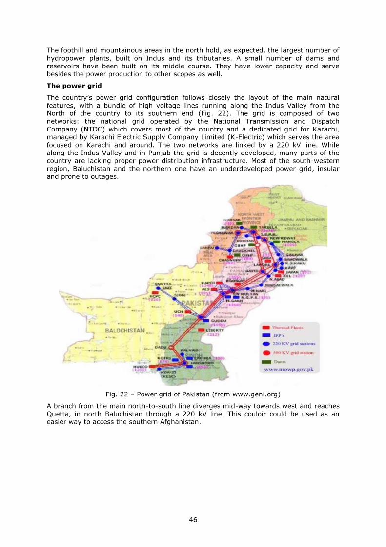
46
The foothill and mountainous areas in the north hold, as expected, the largest number of
hydropower plants, built on Indus and its tributaries. A small number of dams and
reservoirs have been built on its middle course. They have lower capacity and serve
besides the power production to other scopes as well.
The power grid
The country’s power grid configuration follows closely the layout of the main natural
features, with a bundle of high voltage lines running along the Indus Valley from the
North of the country to its southern end (Fig. 22). The grid is composed of two
networks: the national grid operated by the National Transmission and Dispatch
Company (NTDC) which covers most of the country and a dedicated grid for Karachi,
managed by Karachi Electric Supply Company Limited (K-Electric) which serves the area
focused on Karachi and around. The two networks are linked by a 220 kV line. While
along the Indus Valley and in Punjab the grid is decently developed, many parts of the
country are lacking proper power distribution infrastructure. Most of the south-western
region, Baluchistan and the northern one have an underdeveloped power grid, insular
and prone to outages.
Fig. 22 – Power grid of Pakistan (from www.geni.org)
A branch from the main north-to-south line diverges mid-way towards west and reaches
Quetta, in north Baluchistan through a 220 kV line. This couloir could be used as an
easier way to access the southern Afghanistan.
47
3.12 Tajikistan
Geographical traits
Tajikistan is a landlocked country in Central Asia covered on more than 90% of its
territory by mountains, more than half of its area being above 3000 m. Its shape betrays
the valleys and ridges configuration with few unusually prolongations following ethnic
population distribution. The high-gradient valleys together with the presence of glaciers
assure a high hydro power potential. The eastern part of the country is practically full
covered by Pamir Mountains with altitudes ranging from 3000 m to 7000 m. The harsh
high mountain climate poses difficulties to transportation, infrastructure maintenance
and economic activities. The southern border with Afghanistan is represented by the
upper sector of Amu-Darya called here Panj.
Despite the mountainous landscape the country is moderately populated – more than 8
million inhabitants which occupy the main valleys and lower areas in southwest, where
the capital Dushanbe is located and the northwest along a part of Syr-Darya River, called
locally Fergana Valley. Just a little bit more than a quarter of them live in urban areas.
The main economic activity is agriculture performed in low-laying areas while industry is
poorly represented. The country possesses large aluminium reserves which contributes
massively to its export revenues.
Tajikistan was the poorest republic in Soviet Central Asia and it preserves the same
position after independence. Its reliance on aluminium and agriculture (cotton) exposes
it to external price fluctuations with unreliable revenues.
Power generation and consumption
With its mountainous topography Tajikistan was meant to be, along with Kyrgyzstan, the
hydro powerhouse of the region, possessing 4% of the world’s hydropower potential and
more than half of the one of Central Asia’s. The country ranks the first in the World by
density of hydropower potential (3696,9 thousand kWh/ year/km2) but only approx. 5%
is exploited.
Most of the investments in building power generation capacities went to hydro power
plants. More than 97% of its electricity is produced from hydro sources, the rest coming
from gas. The total installed power capacity of the country amounts 5200 MW.
The production of electricity was around 16000 kWh in 2014 while the consumption
12000 kWh which makes the country a net exporter of electricity. Before being
disconnected from the common Central Asian grid this surplus went to feed the other ex-
Soviet republics but now the only outlet is Afghanistan. The combination of heavy
reliance on hydropower and harsh hibernal mountainous climate makes the winter
blackouts a common occurrence. In order to avoid this situation the government sought
to diversify the fuel and lastly a 200 MW coal-fired power plant has been built close to
Dushanbe with Chinese financial and technological help (US Department of Commerce,
2015).
The power grid
The country’s power grid was designed and built in 1970s under a common integrated
scheme with the other Central Asian former Soviet republics (Fig. 19). The mountainous
nature of its territory is reflected in the power grid configuration with the eastern part
basically lacking high voltage infrastructure, relying on local low power grids. One branch
of the 500 kV line, designed to be the backbone of the common system, enters
Tajikistan to allow power produced at Nurekskaya Hydro Plant (3000 MW) to feed the
system. Another branch of the 500 kV line passes through Tajikistan’s part of Fergana
Valley coming from and leaving to Uzbekistan.
In the last decades, after the former Soviet Central Asian countries declared and
obtained independence, the former structure of the power grid became obsolete in front
of the newly energy goals of each country. So happened in 2009 when Uzbekistan

48
disconnected from the common power grid with repercussions over neighbouring
countries rendering Tajikistan’s power grid to function as an island.
The advanced age of the infrastructure and its poor maintenance increase the losses of
the power system to approx. 17%.
The rough mountainous landscape of Tajikistan poses serious problems for grid
extensions over a large part of its territory. The costs to build new infrastructure would
be higher than in a low-lying or flat area but also those associated with maintenance in a
climate characterized by high rainfall, often snow and the potential presence of geo-
dynamic processes such as earthquakes, landslides and accelerated erosion.
49
3.13 Turkmenistan
Geographical traits
Turkmenistan is a landlocked country in Central Asia covered on 80% of its territory by
the Karakum desert, one of the driest in the World. Most of its landscape is dominated
by the lowland areas with altitude below 200 m centred on Aral Lake in north and
Caspian Sea in west. Only the eastern quarter and the southern border see higher
altitudes. The river Amu-Darya flows along the northern border heading for the Aral Lake
which massively shrank in the last decades leaving the lakebed exposed to winds which
spread the salts on a large area. Water resources are very limited.
The harsh environmental conditions have a hard word to say on population number and
its distribution. The population is around 5 million and it is distributed along the valley of
Amu-Darya and along the southern border taking advantage of the more humidity
available. The capital Ashgabat is located at the desert’s southern fringes on contact with
the mountains.
Power generation and consumption
The country has big reserves of natural gas and these are used extensively to produce
electricity. Most of the electricity produced comes from gas-fired thermal plants (99%)
and just a tiny fraction from hydro (1%). The state policy – or rather of its leader – is to
provide electricity and gas free for all citizens until 2030.
Most of the electricity consumed in the country goes to industry and agriculture due to
the numerous and powerful pumping stations required for a sufficient level of irrigation.
With so much cheap and easy to extract gas Turkmenistan is a net exporter of electricity
to Iran and Turkey. The plans for future foresee an increase of the gas-fired plants
capacity with the scope of becoming a major electricity provider for neighbouring and
more distant countries. The cheap gas and electricity prices deter investments in
renewable energy such as wind and especially solar of which Turkmenistan possesses
great potential.
The power grid
The power grid of Turkmenistan was designed as part of the Central Asian Soviet
republics where the power flew irrespective of the borders, electricity being produced
where the sources and reserves were available and consumed where it was needed (Fig.
19). Most of the power grid was built during 1970s and since then it underwent
insufficient overhaul which translates today in big losses and powerlessness to provide a
good service of supply.
The peripheral location of the country made the 500 kV main line, coming from
Uzbekistan, to have its terminus here. The central location of the Karakum Desert made
the grid to develop into two 110 kV branches: a northern one along Amu-Darya valley
and a southern one along the Kopetdag Mountains which make the border with Iran.
Except from where they diverge, the branches are standalone without coming again into
contact, thus acting as cul-de-sac.
After the independence each country sought to follow its own interests in energy policy.
That determined some of the countries to disconnect from the common power grid and
function in isolation or build new connections. This is the path Turkmenistan chose to
follow in 2003 when, after disconnecting from Uzbekistan and thus the common grid, it
strengthen its links with Iran with whom it operates in parallel and from whom receives
frequency control service.
50
3.14 Uzbekistan
Geographical traits
Uzbekistan is, like all the countries in Central Asia, a landlocked country with a
pronounced asymmetry in environmental conditions and population distribution. The
southeast of the country is higher with a more humid climate which determined the
population to settle here. The north-western part is covered by steppes and the Desert
Kyzyl-Kum. The country extends between the two main rivers that run parallel and end
in the Aral Sea: Syr-Darya in north and Amu-Darya in south. Population settled along
these rivers where today powerful pumping stations divert their waters for irrigation.
This water intake is the major cause of the Aral Lake shrinking leaving its salt-covered
lakebed exposed to winds which spread the salts in surrounding area. The upper part of
Syr-Darya valley bears the name of Fergana Valley which has been inhabited since
ancient times and still continues to be the heart of the population concentration which
comprises the country’s capital Tashkent. The climate is dry subtropical continental in
west and milder as one move eastward, even colder in south-eastern mountain ranges.
Power generation and consumption
The power sector of the country from generation to transmission and distribution is
owned and operated by Uzbekenergo under its subsidiaries.
The rich gas reserves determined the country’s choice for gas-fired thermal plants which
account for 82% of the total installed capacity (12510 MW) with the rest going to hydro
(12%) and coal (5%) (Kochnakyan, et al., 2013). This combination of generation makes
the price of electricity rather low which deters investment in other renewable energy
sources such as solar whose potential is large in Uzbekistan.
Almost all the power plants are nearing or even going beyond their projected service
lifetime which causes them to run less efficiently. The efficiency of the power generation
sector is one of the lowest in the area. Also, as lately some of the countries decided to
disconnect from the common system the grids started to function in isolation.
Uzbekistan’s gas-fired power plants were designed to cover the base load but under the
new setting they are solicited to cover the peak loads or to go off during the
consumption dips. This switch decreases the plants’ thermal efficiency and creates
outages since the plants cannot respond to load’s quick changes.
Industrial consumption reaches almost half of the total consumption (45%) but the
residential consumption (25%) increased more than 70% in the last decade.
Although the country is able to meet its domestic needs from internal sources it has
power exchanges with the neighbours. Export occurs especially during winter times when
some countries (e.g. Tajikistan) cannot use their hydro generation while import during
summer when Kyrgyzstan and Tajikistan have surplus from hydro.
The power grid
The country’s power grid is closely interconnected with the neighbours’ ones as it is the
case with all the ex-USSR Central Asian countries (Fig. 19). While this worked fine during
the times is was built and developed now it is a major source of contention since every
now independent country pursues its own energy policy. This can be seen in countries’
attempts to reshape their power grid according to their strategies in exploiting domestic
energy sources or ensuring security of supply for different areas. These reasons led
Uzbekistan in 2009 to withdraw from regional power grid which affected the power flow
and security of supply of Kyrgyzstan and Tajikistan especially during winter months
(Radio Free Europe/Radio Liberty, 2009).
The backbone of the grid is represented by a 500 kV line connected further to
Kazakhstan, Kyrgyzstan and Turkmenistan. The higher density is found in east and south
where most of the population lives while in west the grid is patchy. As it is the case with
other Central Asian countries, the grid was built during Soviet times and without much of

51
refurbish it is now in a rather bad state, especially in rural areas (Kochnakyan, et al.,
2013). Much investment is needed for rehabilitation along with construction of new lines
for the growing demand. The transmission lines run across approx. 23000 km. The
losses amount to 20% of generation and affect especially the lower transmission (110
kV) and distribution lines. They are mainly caused by overloading the lines.
After 2003 when Turkmenistan disconnected from the common power grid and 2010
when Tajikistan did the same the power exchange had a lot to suffer and today it is
limited in number of active lines/links and quantities transacted missing important
opportunities for trade but also for increasing the efficiency of the system operation and
reliability.
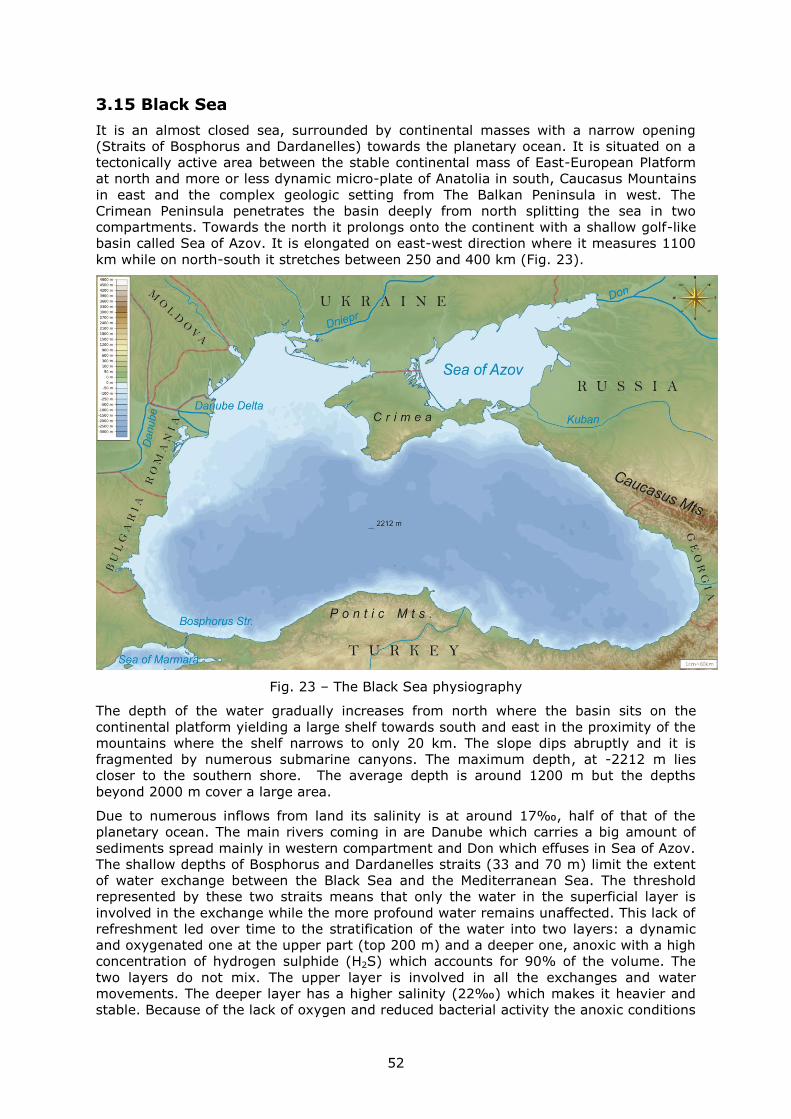
52
3.15 Black Sea
It is an almost closed sea, surrounded by continental masses with a narrow opening
(Straits of Bosphorus and Dardanelles) towards the planetary ocean. It is situated on a
tectonically active area between the stable continental mass of East-European Platform
at north and more or less dynamic micro-plate of Anatolia in south, Caucasus Mountains
in east and the complex geologic setting from The Balkan Peninsula in west. The
Crimean Peninsula penetrates the basin deeply from north splitting the sea in two
compartments. Towards the north it prolongs onto the continent with a shallow golf-like
basin called Sea of Azov. It is elongated on east-west direction where it measures 1100
km while on north-south it stretches between 250 and 400 km (Fig. 23).
Fig. 23 – The Black Sea physiography
The depth of the water gradually increases from north where the basin sits on the
continental platform yielding a large shelf towards south and east in the proximity of the
mountains where the shelf narrows to only 20 km. The slope dips abruptly and it is
fragmented by numerous submarine canyons. The maximum depth, at -2212 m lies
closer to the southern shore. The average depth is around 1200 m but the depths
beyond 2000 m cover a large area.
Due to numerous inflows from land its salinity is at around 17‰, half of that of the
planetary ocean. The main rivers coming in are Danube which carries a big amount of
sediments spread mainly in western compartment and Don which effuses in Sea of Azov.
The shallow depths of Bosphorus and Dardanelles straits (33 and 70 m) limit the extent
of water exchange between the Black Sea and the Mediterranean Sea. The threshold
represented by these two straits means that only the water in the superficial layer is
involved in the exchange while the more profound water remains unaffected. This lack of
refreshment led over time to the stratification of the water into two layers: a dynamic
and oxygenated one at the upper part (top 200 m) and a deeper one, anoxic with a high
concentration of hydrogen sulphide (H2S) which accounts for 90% of the volume. The
two layers do not mix. The upper layer is involved in all the exchanges and water
movements. The deeper layer has a higher salinity (22‰) which makes it heavier and
stable. Because of the lack of oxygen and reduced bacterial activity the anoxic conditions

53
proved to be very favourable to preserving ancient artefacts. These anoxic conditions
must be taken into consideration when designing submarine structures.
The Black Sea is bordered by six countries: Bulgaria, Romania, Ukraine, Russia, Georgia
and Turkey.
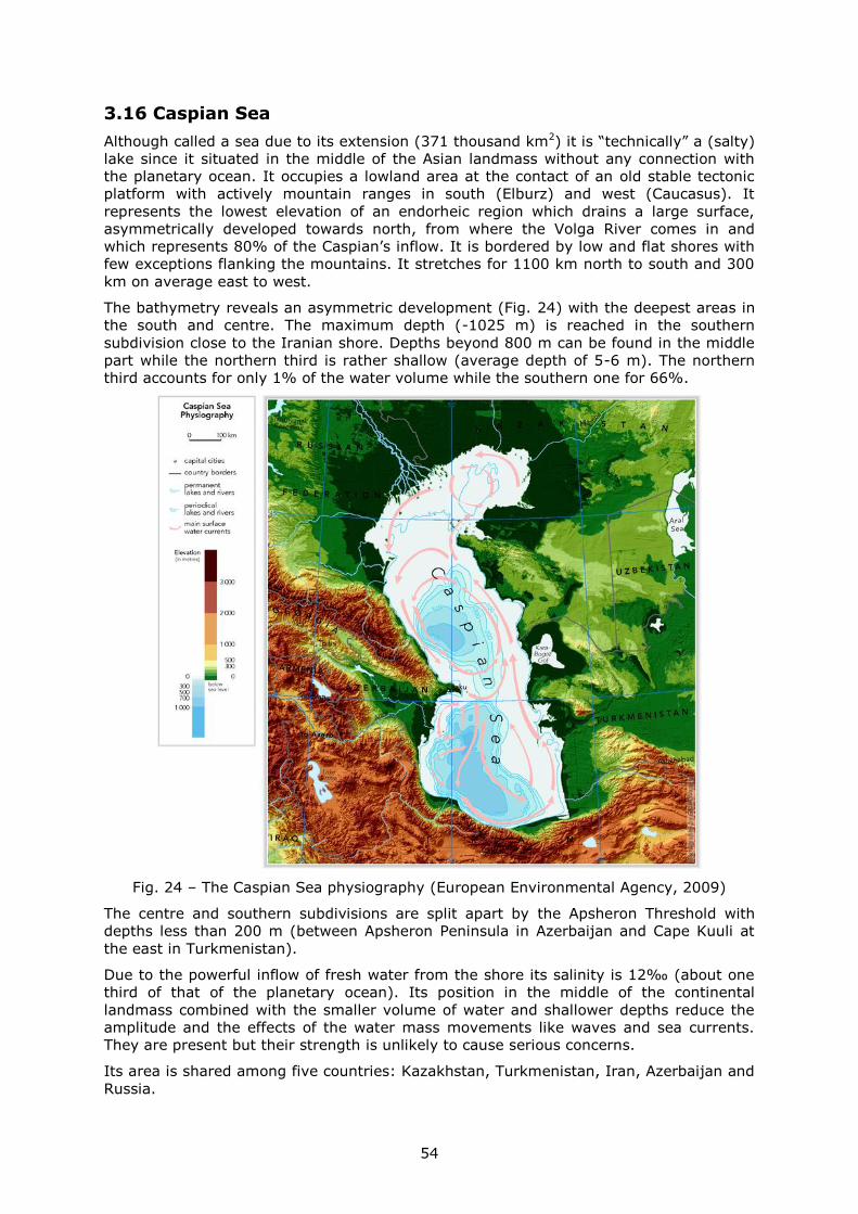
54
3.16 Caspian Sea
Although called a sea due to its extension (371 thousand km2) it is “technically” a (salty)
lake since it situated in the middle of the Asian landmass without any connection with
the planetary ocean. It occupies a lowland area at the contact of an old stable tectonic
platform with actively mountain ranges in south (Elburz) and west (Caucasus). It
represents the lowest elevation of an endorheic region which drains a large surface,
asymmetrically developed towards north, from where the Volga River comes in and
which represents 80% of the Caspian’s inflow. It is bordered by low and flat shores with
few exceptions flanking the mountains. It stretches for 1100 km north to south and 300
km on average east to west.
The bathymetry reveals an asymmetric development (Fig. 24) with the deepest areas in
the south and centre. The maximum depth (-1025 m) is reached in the southern
subdivision close to the Iranian shore. Depths beyond 800 m can be found in the middle
part while the northern third is rather shallow (average depth of 5-6 m). The northern
third accounts for only 1% of the water volume while the southern one for 66%.
Fig. 24 – The Caspian Sea physiography (European Environmental Agency, 2009)
The centre and southern subdivisions are split apart by the Apsheron Threshold with
depths less than 200 m (between Apsheron Peninsula in Azerbaijan and Cape Kuuli at
the east in Turkmenistan).
Due to the powerful inflow of fresh water from the shore its salinity is 12‰ (about one
third of that of the planetary ocean). Its position in the middle of the continental
landmass combined with the smaller volume of water and shallower depths reduce the
amplitude and the effects of the water mass movements like waves and sea currents.
They are present but their strength is unlikely to cause serious concerns.
Its area is shared among five countries: Kazakhstan, Turkmenistan, Iran, Azerbaijan and
Russia.
55
4 China-Europe HVDC link
4.1 Framework
Given the long distance between the considered end-points (western China and eastern
Central Europe, over 6500 km), the losses for a single continuous HVDC line would be
very high. The solution could be a multi-terminal system in which the main line would
function as a thoroughfare connected to several secondary lines that feed in or take out
electricity. This configuration would allow the integration of numerous RES along the
route (wind, solar hydro form north-western China, Kazakhstan) as well as enhanced
trading opportunities for countries along the line.
Central Asia is a region rich in energy resources whether they are conventional fossil
(coal, oil, gas), uranium, hydro or renewables (wind, solar). This richness, especially
renewables, could be turned into electricity and consumed locally but also exported to
countries outside the realm. This would constitute an important source of income which
would support local development. For Europe, a big energy consumer, which gradually
reaches its maximum potential in harnessing the most favourable (and least costly) RES,
this power influx of cheaper and clean energy would mean touching the present but also
future decarbonisation targets.
The influx of large quantities of renewable energy with its characteristics (variability,
inconsistence, disparity in relation with the demand) will certainly put pressure over the
nowadays power grid. In order to be able to absorb this quantity of electricity and to
properly handle it the nowadays power grid must be reformed and modernized. One of
the solutions could be the model proposed by (Fulli, Purvins, Rüberg, L'Abbate, &
Migliavacca, 2011) for Europe by mixing the HVAC grid with a newly created HVDC one.
The HVDC lines would allow the transmission of large quantities of electricity over long
distances with minimized costs.
Taking into account the perspectives of technologic development, probably the most
viable solution would be the use of HVDC VSC technology. This is suited for multi-
terminal configuration and offers a larger palette for power control.
4.2 Benefits
A long longitudinal-developed power interconnection spread over many time zones could
take advantage of the different behavioural rhythms of the population in the meantime
optimizing the use of electricity. It would also ease the use of the variable renewables
like wind which otherwise would be curtailed when the load or the grid could not take
them.
There is a difference of more than 7 hours between Europe CET and China (Fig. 25).
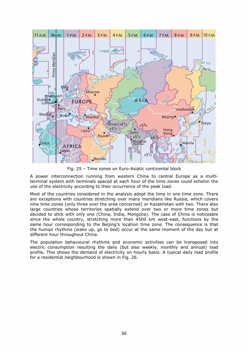
56
Fig. 25 – Time zones on Euro-Asiatic continental block
A power interconnection running from western China to central Europe as a multi-
terminal system with terminals spaced at each hour of the time zones could echelon the
use of the electricity according to their occurrence of the peak load.
Most of the countries considered in the analysis adopt the time in one time zone. There
are exceptions with countries stretching over many meridians like Russia, which covers
nine time zones (only three over the area concerned) or Kazakhstan with two. There also
large countries whose territories spatially extend over two or more time zones but
decided to stick with only one (China, India, Mongolia). The case of China is noticeable
since the whole country, stretching more than 4500 km west-east, functions by the
same hour corresponding to the Beijing’s location time zone. The consequence is that
the human rhythms (wake up, go to bed) occur at the same moment of the day but at
different hour throughout China.
The population behavioural rhythms and economic activities can be transposed into
electric consumption resulting the daily (but also weekly, monthly and annual) load
profile. This shows the demand of electricity on hourly basis. A typical daily load profile
for a residential neighbourhood is shown in Fig. 26.
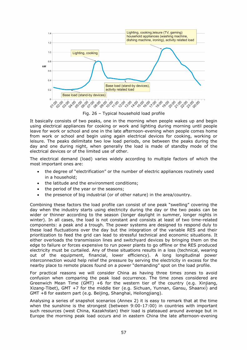
57
Fig. 26 – Typical household load profile
It basically consists of two peaks, one in the morning when people wakes up and begin
using electrical appliances for cooking or work and lighting during morning until people
leave for work or school and one in the late afternoon-evening when people comes home
from work or school and begin using again electrical devices for cooking, working or
leisure. The peaks delimitate two low load periods, one between the peaks during the
day and one during night, when generally the load is made of standby mode of the
electrical devices or of the limited use of other.
The electrical demand (load) varies widely according to multiple factors of which the
most important ones are:
the degree of “electrification” or the number of electric appliances routinely used
in a household;
the latitude and the environment conditions;
the period of the year or the seasons;
the presence of big industrial (or of other nature) in the area/country.
Combining these factors the load profile can consist of one peak “swelling” covering the
day when the industry starts using electricity during the day or the two peaks can be
wider or thinner according to the season (longer daylight in summer, longer nights in
winter). In all cases, the load is not constant and consists at least of two time-related
components: a peak and a trough. The power systems are designed to respond duly to
these load fluctuations over the day but the integration of the variable RES and their
prioritization to feed the grid can lead to stressful technical and economic situations. It
either overloads the transmission lines and switchyard devices by bringing them on the
edge to failure or forces expensive to run power plants to go offline or the RES produced
electricity must be curtailed. Any of these situations results in a loss (technical, wearing
out of the equipment, financial, lower efficiency). A long longitudinal power
interconnection would help relief the pressure by serving the electricity in excess for the
nearby place to remote places found on a power “demanding” spot on the load profile.
For practical reasons we will consider China as having three times zones to avoid
confusion when comparing the peak load occurrence. The time zones considered are
Greenwich Mean Time (GMT) +6 for the western tier of the country (e.g. Xinjiang,
Xizang-Tibet), GMT +7 for the middle tier (e.g. Sichuan, Yunnan, Gansu, Shaanxi) and
GMT +8 for eastern part (e.g. Beijing, Shanghai, Heilongjiang).
Analysing a series of snapshot scenarios (Annex 2) it is easy to remark that at the time
when the sunshine is the strongest (between 9:00-17:00) in countries with important
such resources (west China, Kazakhstan) their load is plateaued around average but in
Europe the morning peak load occurs and in eastern China the late afternoon-evening
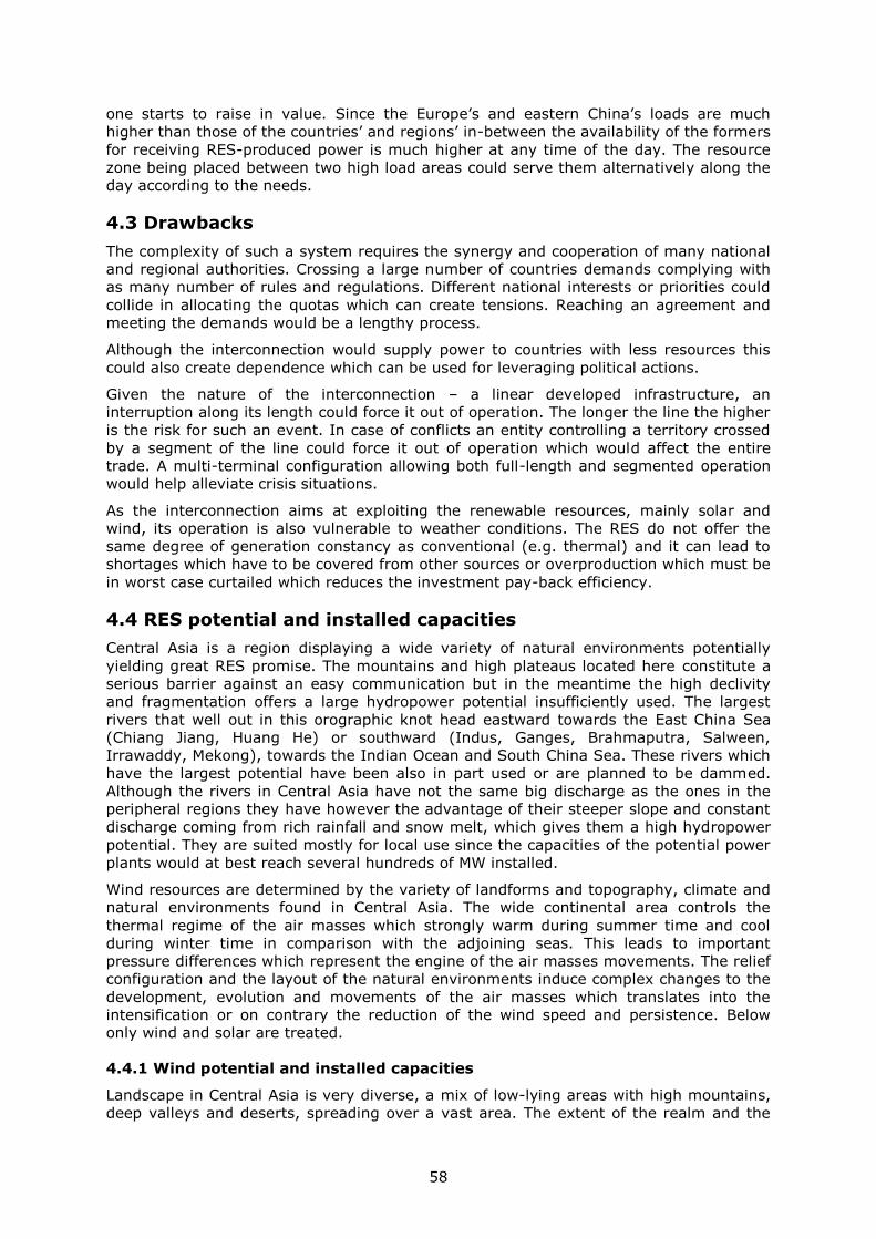
58
one starts to raise in value. Since the Europe’s and eastern China’s loads are much
higher than those of the countries’ and regions’ in-between the availability of the formers
for receiving RES-produced power is much higher at any time of the day. The resource
zone being placed between two high load areas could serve them alternatively along the
day according to the needs.
4.3 Drawbacks
The complexity of such a system requires the synergy and cooperation of many national
and regional authorities. Crossing a large number of countries demands complying with
as many number of rules and regulations. Different national interests or priorities could
collide in allocating the quotas which can create tensions. Reaching an agreement and
meeting the demands would be a lengthy process.
Although the interconnection would supply power to countries with less resources this
could also create dependence which can be used for leveraging political actions.
Given the nature of the interconnection – a linear developed infrastructure, an
interruption along its length could force it out of operation. The longer the line the higher
is the risk for such an event. In case of conflicts an entity controlling a territory crossed
by a segment of the line could force it out of operation which would affect the entire
trade. A multi-terminal configuration allowing both full-length and segmented operation
would help alleviate crisis situations.
As the interconnection aims at exploiting the renewable resources, mainly solar and
wind, its operation is also vulnerable to weather conditions. The RES do not offer the
same degree of generation constancy as conventional (e.g. thermal) and it can lead to
shortages which have to be covered from other sources or overproduction which must be
in worst case curtailed which reduces the investment pay-back efficiency.
4.4 RES potential and installed capacities
Central Asia is a region displaying a wide variety of natural environments potentially
yielding great RES promise. The mountains and high plateaus located here constitute a
serious barrier against an easy communication but in the meantime the high declivity
and fragmentation offers a large hydropower potential insufficiently used. The largest
rivers that well out in this orographic knot head eastward towards the East China Sea
(Chiang Jiang, Huang He) or southward (Indus, Ganges, Brahmaputra, Salween,
Irrawaddy, Mekong), towards the Indian Ocean and South China Sea. These rivers which
have the largest potential have been also in part used or are planned to be dammed.
Although the rivers in Central Asia have not the same big discharge as the ones in the
peripheral regions they have however the advantage of their steeper slope and constant
discharge coming from rich rainfall and snow melt, which gives them a high hydropower
potential. They are suited mostly for local use since the capacities of the potential power
plants would at best reach several hundreds of MW installed.
Wind resources are determined by the variety of landforms and topography, climate and
natural environments found in Central Asia. The wide continental area controls the
thermal regime of the air masses which strongly warm during summer time and cool
during winter time in comparison with the adjoining seas. This leads to important
pressure differences which represent the engine of the air masses movements. The relief
configuration and the layout of the natural environments induce complex changes to the
development, evolution and movements of the air masses which translates into the
intensification or on contrary the reduction of the wind speed and persistence. Below
only wind and solar are treated.
4.4.1 Wind potential and installed capacities
Landscape in Central Asia is very diverse, a mix of low-lying areas with high mountains,
deep valleys and deserts, spreading over a vast area. The extent of the realm and the
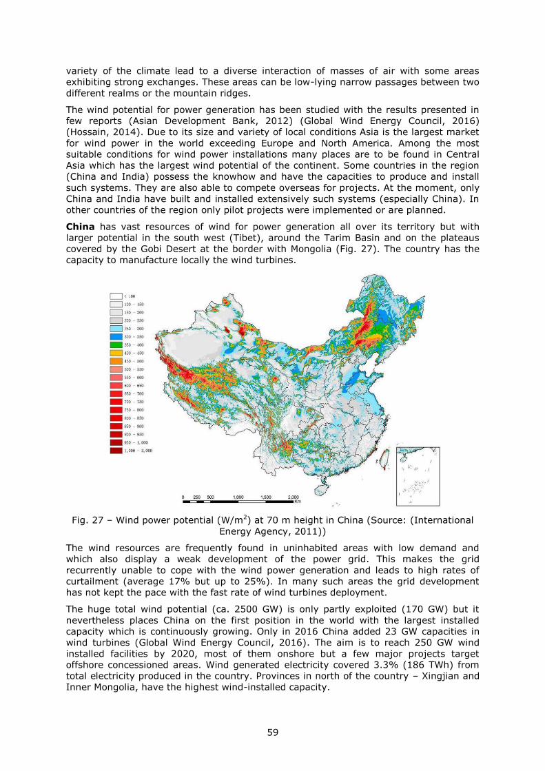
59
variety of the climate lead to a diverse interaction of masses of air with some areas
exhibiting strong exchanges. These areas can be low-lying narrow passages between two
different realms or the mountain ridges.
The wind potential for power generation has been studied with the results presented in
few reports (Asian Development Bank, 2012) (Global Wind Energy Council, 2016)
(Hossain, 2014). Due to its size and variety of local conditions Asia is the largest market
for wind power in the world exceeding Europe and North America. Among the most
suitable conditions for wind power installations many places are to be found in Central
Asia which has the largest wind potential of the continent. Some countries in the region
(China and India) possess the knowhow and have the capacities to produce and install
such systems. They are also able to compete overseas for projects. At the moment, only
China and India have built and installed extensively such systems (especially China). In
other countries of the region only pilot projects were implemented or are planned.
China has vast resources of wind for power generation all over its territory but with
larger potential in the south west (Tibet), around the Tarim Basin and on the plateaus
covered by the Gobi Desert at the border with Mongolia (Fig. 27). The country has the
capacity to manufacture locally the wind turbines.
Fig. 27 – Wind power potential (W/m2) at 70 m height in China (Source: (International
Energy Agency, 2011))
The wind resources are frequently found in uninhabited areas with low demand and
which also display a weak development of the power grid. This makes the grid
recurrently unable to cope with the wind power generation and leads to high rates of
curtailment (average 17% but up to 25%). In many such areas the grid development
has not kept the pace with the fast rate of wind turbines deployment.
The huge total wind potential (ca. 2500 GW) is only partly exploited (170 GW) but it
nevertheless places China on the first position in the world with the largest installed
capacity which is continuously growing. Only in 2016 China added 23 GW capacities in
wind turbines (Global Wind Energy Council, 2016). The aim is to reach 250 GW wind
installed facilities by 2020, most of them onshore but a few major projects target
offshore concessioned areas. Wind generated electricity covered 3.3% (186 TWh) from
total electricity produced in the country. Provinces in north of the country – Xingjian and
Inner Mongolia, have the highest wind-installed capacity.
60
Mongolia has a large wind power potential evenly distributed across the country (Elliot,
et al., 2001). The best areas are situated in the south, covering the Gobi Desert which
extends into China and along the numerous mountain ridges that cross in all directions
the country (Fig. 28). The total wind power potential is estimated at ca. 1100 GW of
which only a tiny part is worked. In the absence of other energy resources, the wind
could be the appropriate source of producing electricity especially in the context of an
increase in the standard of living on the account of the development of the mining
industry. The large potential combined with a favourable topography may offer the
premises for large wind parks development which can turn Mongolia into a net exporter
of electricity.
Fig. 28 – Wind power potential in Mongolia
The large and free of obstacles areas of Kazakhstan make the country almost entirely
suited for power wind generation. The wind power potentials amounts 760 GW.
However, cheap coal and gas are for the moment a strong deterrent to a widely
investment in wind turbines. Nevertheless, there are good opportunities for wind
harvesting since some of the best sites for wind power generation are close to the
existing transmission lines which may require minimum grid investments in order to
readily ship the wind generated electricity to the consumers.
Uzbekistan and Turkmenistan have similar natural environments with wide spread
desert or semiarid zones on most of their surfaces in the west and slightly higher
terrains in the south and east, more accentuated in the case of south-eastern
Uzbekistan. Being situated in the middle of the continental block, far away from the wide
aquatic surfaces, the most dynamic borderline interaction in the two mediums is not felt
here. There is however an active dynamic between the continental masses of air with
different properties which sweep the area. The flatness of the area and the lack of forest
vegetation offer ideal conditions for wind harvesting even at medium speeds and
frequencies.
61
Kirghizstan and Tajikistan are both mountainous countries sharing the same type of
environment and natural conditions. For that reason the wind speed, frequency and
hence the potential is tear according to the topography: low speed and extended
atmospheric calm in the lowland areas/depressions and high speed and frequency on the
ridges. As the sequence of these types of landforms occurs densely the potential varies
accordingly. Only in the eastern part of Tajikistan, in Pamir High Plateau the potential is
more consistent spread over the territory. Given the difficulty to cross the mountain
ridges with transmission lines, probably the best solution is to tap and use the wind
potential locally. The electricity derived from wind, along with that from solar and hydro,
the three large resources of the area, could cover the consumption with renewables and
non-pollutant power sources.
Although Myanmar occupies a position between sea at the south and mountains at the
north and east, the regional climatic setting does not favour the creation of masses of air
with very different properties which are prone to very active dynamics. For that reason
the wind speeds within the country are low and moderate. Only locally in the centre of
the country there are areas with higher wind speed that can be economically taped.
Overall the country does not possess a large wind power potential.
Despite its large territory, India has just a few areas with high wind potential (Fig. 29).
These areas stretch along the mountains bordering the coasts on the eastern and
western sides of the peninsula and in the north of the country, in the area dominated by
the heights of Himalaya Mountains. The wind potential totals 300 GW from which almost
10% is tapped, mainly in the north, south and west of the country.
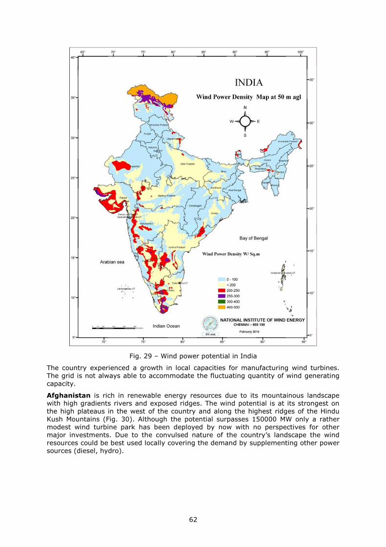
62
Fig. 29 – Wind power potential in India
The country experienced a growth in local capacities for manufacturing wind turbines.
The grid is not always able to accommodate the fluctuating quantity of wind generating
capacity.
Afghanistan is rich in renewable energy resources due to its mountainous landscape
with high gradients rivers and exposed ridges. The wind potential is at its strongest on
the high plateaus in the west of the country and along the highest ridges of the Hindu
Kush Mountains (Fig. 30). Although the potential surpasses 150000 MW only a rather
modest wind turbine park has been deployed by now with no perspectives for other
major investments. Due to the convulsed nature of the country’s landscape the wind
resources could be best used locally covering the demand by supplementing other power
sources (diesel, hydro).
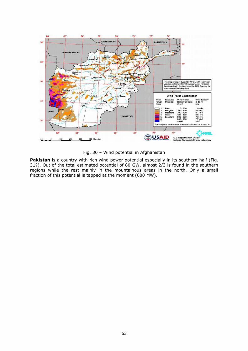
63
Fig. 30 – Wind potential in Afghanistan
Pakistan is a country with rich wind power potential especially in its southern half (Fig.
31?). Out of the total estimated potential of 80 GW, almost 2/3 is found in the southern
regions while the rest mainly in the mountainous areas in the north. Only a small
fraction of this potential is tapped at the moment (600 MW).
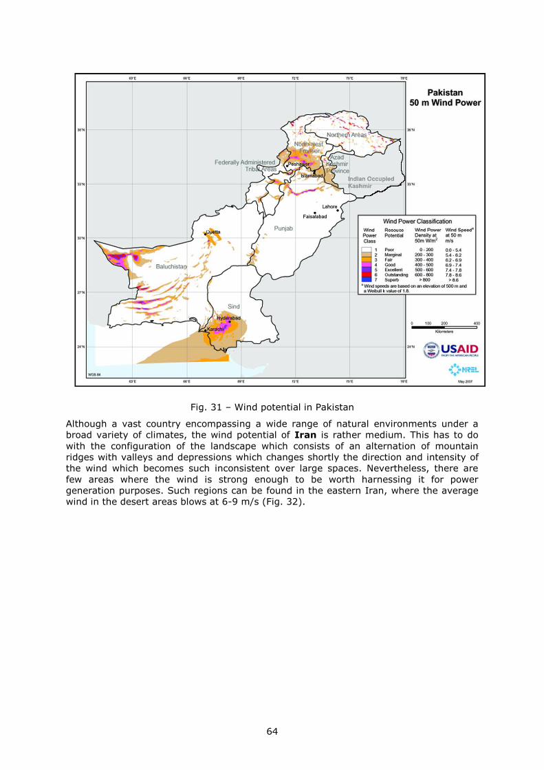
64
Fig. 31 – Wind potential in Pakistan
Although a vast country encompassing a wide range of natural environments under a
broad variety of climates, the wind potential of Iran is rather medium. This has to do
with the configuration of the landscape which consists of an alternation of mountain
ridges with valleys and depressions which changes shortly the direction and intensity of
the wind which becomes such inconsistent over large spaces. Nevertheless, there are
few areas where the wind is strong enough to be worth harnessing it for power
generation purposes. Such regions can be found in the eastern Iran, where the average
wind in the desert areas blows at 6-9 m/s (Fig. 32).
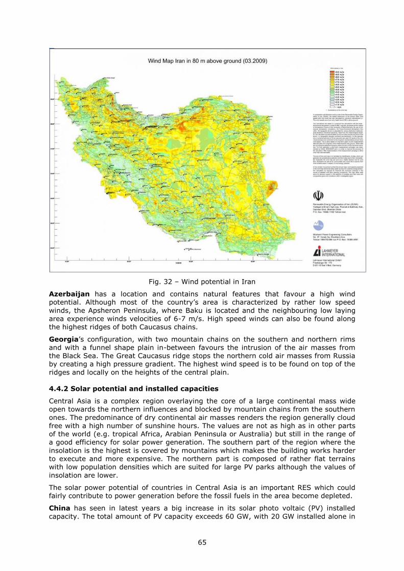
65
Fig. 32 – Wind potential in Iran
Azerbaijan has a location and contains natural features that favour a high wind
potential. Although most of the country’s area is characterized by rather low speed
winds, the Apsheron Peninsula, where Baku is located and the neighbouring low laying
area experience winds velocities of 6-7 m/s. High speed winds can also be found along
the highest ridges of both Caucasus chains.
Georgia’s configuration, with two mountain chains on the southern and northern rims
and with a funnel shape plain in-between favours the intrusion of the air masses from
the Black Sea. The Great Caucasus ridge stops the northern cold air masses from Russia
by creating a high pressure gradient. The highest wind speed is to be found on top of the
ridges and locally on the heights of the central plain.
4.4.2 Solar potential and installed capacities
Central Asia is a complex region overlaying the core of a large continental mass wide
open towards the northern influences and blocked by mountain chains from the southern
ones. The predominance of dry continental air masses renders the region generally cloud
free with a high number of sunshine hours. The values are not as high as in other parts
of the world (e.g. tropical Africa, Arabian Peninsula or Australia) but still in the range of
a good efficiency for solar power generation. The southern part of the region where the
insolation is the highest is covered by mountains which makes the building works harder
to execute and more expensive. The northern part is composed of rather flat terrains
with low population densities which are suited for large PV parks although the values of
insolation are lower.
The solar power potential of countries in Central Asia is an important RES which could
fairly contribute to power generation before the fossil fuels in the area become depleted.
China has seen in latest years a big increase in its solar photo voltaic (PV) installed
capacity. The total amount of PV capacity exceeds 60 GW, with 20 GW installed alone in
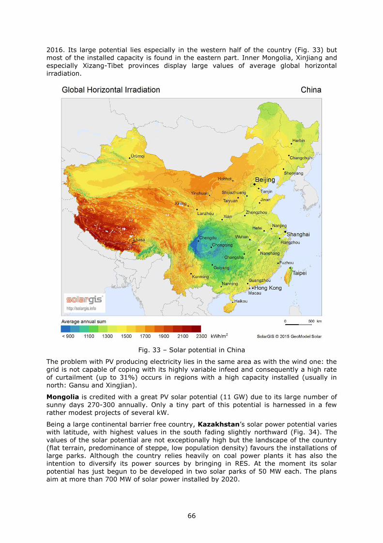
66
2016. Its large potential lies especially in the western half of the country (Fig. 33) but
most of the installed capacity is found in the eastern part. Inner Mongolia, Xinjiang and
especially Xizang-Tibet provinces display large values of average global horizontal
irradiation.
Fig. 33 – Solar potential in China
The problem with PV producing electricity lies in the same area as with the wind one: the
grid is not capable of coping with its highly variable infeed and consequently a high rate
of curtailment (up to 31%) occurs in regions with a high capacity installed (usually in
north: Gansu and Xingjian).
Mongolia is credited with a great PV solar potential (11 GW) due to its large number of
sunny days 270-300 annually. Only a tiny part of this potential is harnessed in a few
rather modest projects of several kW.
Being a large continental barrier free country, Kazakhstan’s solar power potential varies
with latitude, with highest values in the south fading slightly northward (Fig. 34). The
values of the solar potential are not exceptionally high but the landscape of the country
(flat terrain, predominance of steppe, low population density) favours the installations of
large parks. Although the country relies heavily on coal power plants it has also the
intention to diversify its power sources by bringing in RES. At the moment its solar
potential has just begun to be developed in two solar parks of 50 MW each. The plans
aim at more than 700 MW of solar power installed by 2020.
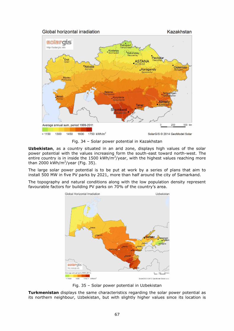
67
Fig. 34 – Solar power potential in Kazakhstan
Uzbekistan, as a country situated in an arid zone, displays high values of the solar
power potential with the values increasing form the south-east toward north-west. The
entire country is in inside the 1500 kWh/m2/year, with the highest values reaching more
than 2000 kWh/m2/year (Fig. 35).
The large solar power potential is to be put at work by a series of plans that aim to
install 500 MW in five PV parks by 2021, more than half around the city of Samarkand.
The topography and natural conditions along with the low population density represent
favourable factors for building PV parks on 70% of the country’s area.
Fig. 35 – Solar power potential in Uzbekistan
Turkmenistan displays the same characteristics regarding the solar power potential as
its northern neighbour, Uzbekistan, but with slightly higher values since its location is

68
southern (Fig. 36). It boasts with more than 300 sunny days a year and more than 3000
hours of sunshine a year. Most of the country lies within the 1600 kWh/m2/year limits
with much higher values in the south-east.
There are a lot of discussions on the country’s solar power potential but no concrete
plans have been issued by now. The use of PV panels is mostly local and at small scale
supplying insignificant quantities of electricity.
The natural environmental conditions and the topography of the country along with its
low density of population are the perfect factors for building large PV parks of several
hundreds of MW.
Fig. 36 – Solar power potential in Turkmenistan
Although a mountainous country, Tajikistan possesses a large solar power potential
higher values being found especially in the easternmost part, favoured by the high
plateaus (Fig. 37). Slightly lower values are found in the western part, around the capital
– Dushanbe, where the power grid is better represented. The technical potential capacity
to be installed is estimated at around 195 GW.
The large solar power potential in the eastern part is of little help for feeding the grid in
large quantity due to the rough terrain which requires much work to bring the power
lines across numerous deep valleys and high ridges. It can be used rather locally as local
or isolated grids to serve small communities along with other power sources with high
potential (e.g. hydropower).
At the moment less than 1 MW of solar power is installed and there are not concrete
plans for larger capacities.
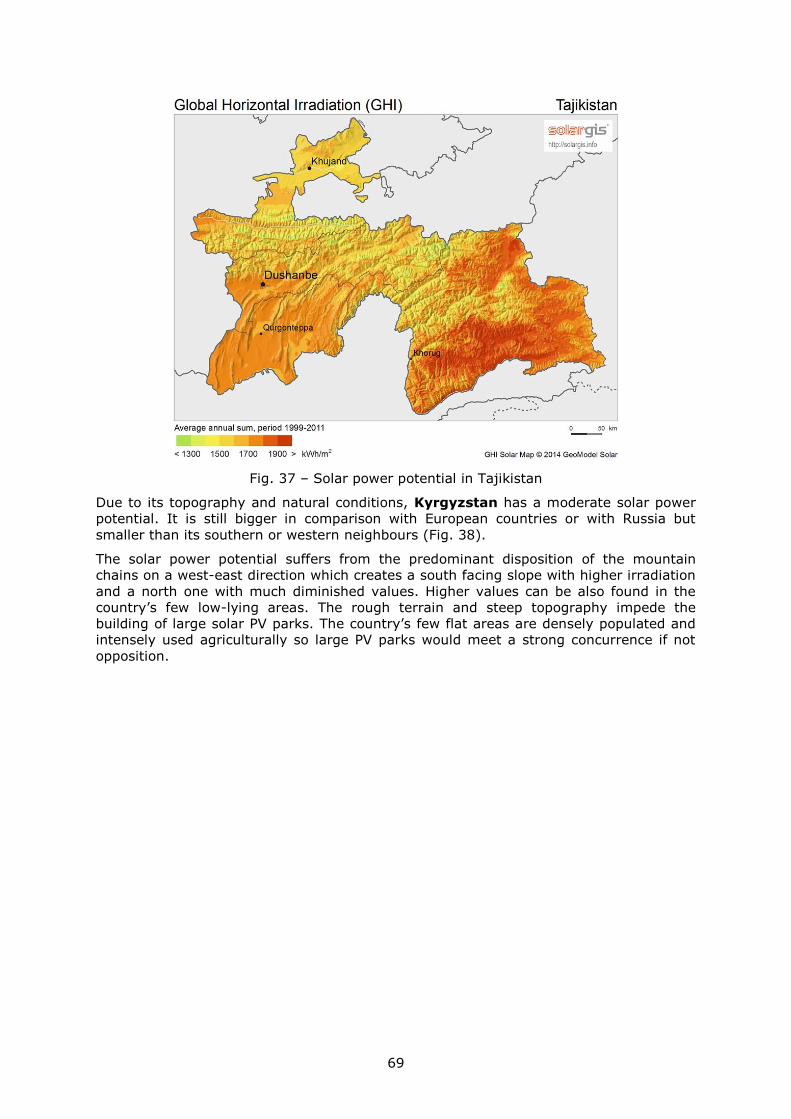
69
Fig. 37 – Solar power potential in Tajikistan
Due to its topography and natural conditions, Kyrgyzstan has a moderate solar power
potential. It is still bigger in comparison with European countries or with Russia but
smaller than its southern or western neighbours (Fig. 38).
The solar power potential suffers from the predominant disposition of the mountain
chains on a west-east direction which creates a south facing slope with higher irradiation
and a north one with much diminished values. Higher values can be also found in the
country’s few low-lying areas. The rough terrain and steep topography impede the
building of large solar PV parks. The country’s few flat areas are densely populated and
intensely used agriculturally so large PV parks would meet a strong concurrence if not
opposition.
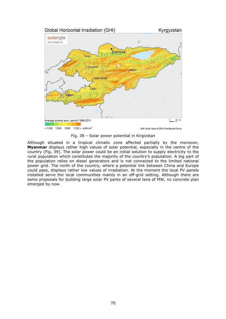
70
Fig. 38 – Solar power potential in Kirgizstan
Although situated in a tropical climatic zone affected partially by the monsoon,
Myanmar displays rather high values of solar potential, especially in the centre of the
country (Fig. 39). The solar power could be an initial solution to supply electricity to the
rural population which constitutes the majority of the country’s population. A big part of
the population relies on diesel generators and is not connected to the limited national
power grid. The north of the country, where a potential link between China and Europe
could pass, displays rather low values of irradiation. At the moment the local PV panels
installed serve the local communities mainly in an off-grid setting. Although there are
some proposals for building large solar PV parks of several tens of MW, no concrete plan
emerged by now.
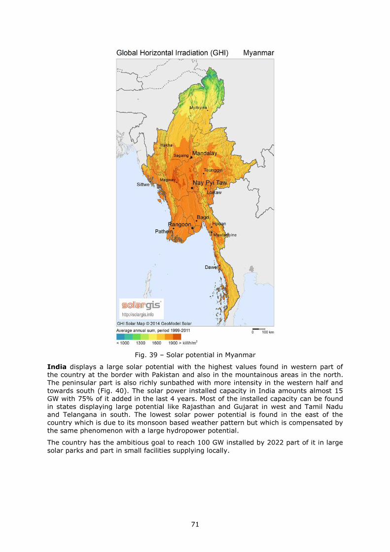
71
Fig. 39 – Solar potential in Myanmar
India displays a large solar potential with the highest values found in western part of
the country at the border with Pakistan and also in the mountainous areas in the north.
The peninsular part is also richly sunbathed with more intensity in the western half and
towards south (Fig. 40). The solar power installed capacity in India amounts almost 15
GW with 75% of it added in the last 4 years. Most of the installed capacity can be found
in states displaying large potential like Rajasthan and Gujarat in west and Tamil Nadu
and Telangana in south. The lowest solar power potential is found in the east of the
country which is due to its monsoon based weather pattern but which is compensated by
the same phenomenon with a large hydropower potential.
The country has the ambitious goal to reach 100 GW installed by 2022 part of it in large
solar parks and part in small facilities supplying locally.
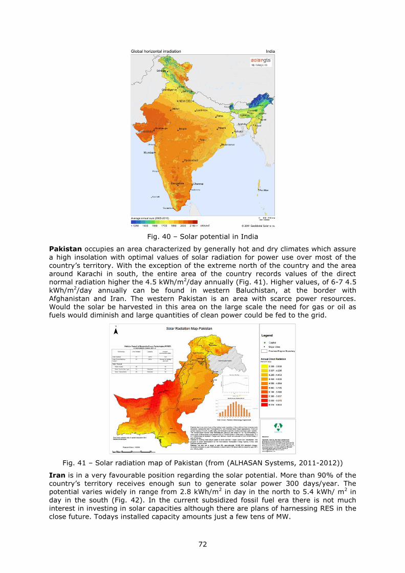
72
Fig. 40 – Solar potential in India
Pakistan occupies an area characterized by generally hot and dry climates which assure
a high insolation with optimal values of solar radiation for power use over most of the
country’s territory. With the exception of the extreme north of the country and the area
around Karachi in south, the entire area of the country records values of the direct
normal radiation higher the 4.5 kWh/m2/day annually (Fig. 41). Higher values, of 6-7 4.5
kWh/m2/day annually can be found in western Baluchistan, at the border with
Afghanistan and Iran. The western Pakistan is an area with scarce power resources.
Would the solar be harvested in this area on the large scale the need for gas or oil as
fuels would diminish and large quantities of clean power could be fed to the grid.
Fig. 41 – Solar radiation map of Pakistan (from (ALHASAN Systems, 2011-2012))
Iran is in a very favourable position regarding the solar potential. More than 90% of the
country’s territory receives enough sun to generate solar power 300 days/year. The
potential varies widely in range from 2.8 kWh/m2 in day in the north to 5.4 kWh/ m2 in
day in the south (Fig. 42). In the current subsidized fossil fuel era there is not much
interest in investing in solar capacities although there are plans of harnessing RES in the
close future. Todays installed capacity amounts just a few tens of MW.
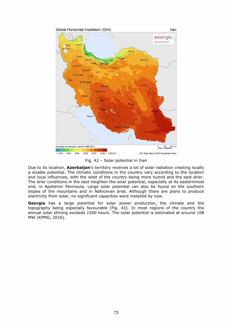
73
Fig. 42 – Solar potential in Iran
Due to its location, Azerbaijan’s territory receives a lot of solar radiation creating locally
a sizable potential. The climatic conditions in the country vary according to the location
and local influences, with the west of the country being more humid and the east drier.
The drier conditions in the east heighten the solar potential, especially at its easternmost
end, in Apsheron Peninsula. Large solar potential can also be found on the southern
slopes of the mountains and in Nahicevan area. Although there are plans to produce
electricity from solar, no significant capacities were installed by now.
Georgia has a large potential for solar power production, the climate and the
topography being especially favourable (Fig. 43). In most regions of the country the
annual solar shining exceeds 1500 hours. The solar potential is estimated at around 108
MW (KPMG, 2016).
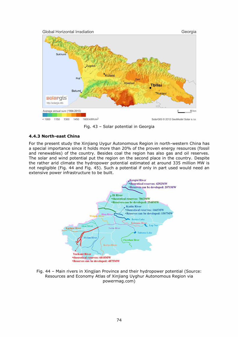
74
Fig. 43 – Solar potential in Georgia
4.4.3 North-east China
For the present study the Xinjiang Uygur Autonomous Region in north-western China has
a special importance since it holds more than 20% of the proven energy resources (fossil
and renewables) of the country. Besides coal the region has also gas and oil reserves.
The solar and wind potential put the region on the second place in the country. Despite
the rather arid climate the hydropower potential estimated at around 335 million MW is
not negligible (Fig. 44 and Fig. 45). Such a potential if only in part used would need an
extensive power infrastructure to be built.
Fig. 44 – Main rivers in Xingjian Province and their hydropower potential (Source:
Resources and Economy Atlas of Xinjiang Uyghur Autonomous Region via
powermag.com)
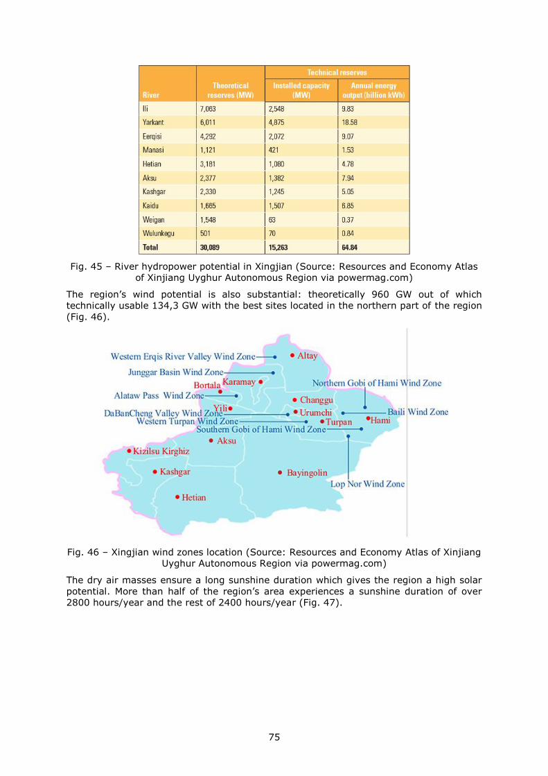
75
Fig. 45 – River hydropower potential in Xingjian (Source: Resources and Economy Atlas
of Xinjiang Uyghur Autonomous Region via powermag.com)
The region’s wind potential is also substantial: theoretically 960 GW out of which
technically usable 134,3 GW with the best sites located in the northern part of the region
(Fig. 46).
Fig. 46 – Xingjian wind zones location (Source: Resources and Economy Atlas of Xinjiang
Uyghur Autonomous Region via powermag.com)
The dry air masses ensure a long sunshine duration which gives the region a high solar
potential. More than half of the region’s area experiences a sunshine duration of over
2800 hours/year and the rest of 2400 hours/year (Fig. 47).
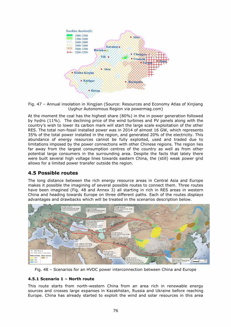
76
Fig. 47 – Annual insolation in Xingjian (Source: Resources and Economy Atlas of Xinjiang
Uyghur Autonomous Region via powermag.com)
At the moment the coal has the highest share (80%) in the in power generation followed
by hydro (11%). The declining price of the wind turbines and PV panels along with the
country’s wish to lower its carbon mark will start the large scale exploitation of the other
RES. The total non-fossil installed power was in 2014 of almost 16 GW, which represents
35% of the total power installed in the region, and generated 20% of the electricity. This
abundance of energy resources cannot be fully exploited, used and traded due to
limitations imposed by the power connections with other Chinese regions. The region lies
far away from the largest consumption centres of the country as well as from other
potential large consumers in the surrounding area. Despite the facts that lately there
were built several high voltage lines towards eastern China, the (still) weak power grid
allows for a limited power transfer outside the region.
4.5 Possible routes
The long distance between the rich energy resource areas in Central Asia and Europe
makes it possible the imagining of several possible routes to connect them. Three routes
have been imagined (Fig. 48 and Annex 3) all starting in rich in RES areas in western
China and heading towards Europe on three different paths. Each of the routes displays
advantages and drawbacks which will be treated in the scenarios description below.
Fig. 48 – Scenarios for an HVDC power interconnection between China and Europe
4.5.1 Scenario 1 – North route
This route starts from north-western China from an area rich in renewable energy
sources and crosses large expanses in Kazakhstan, Russia and Ukraine before reaching
Europe. China has already started to exploit the wind and solar resources in this area
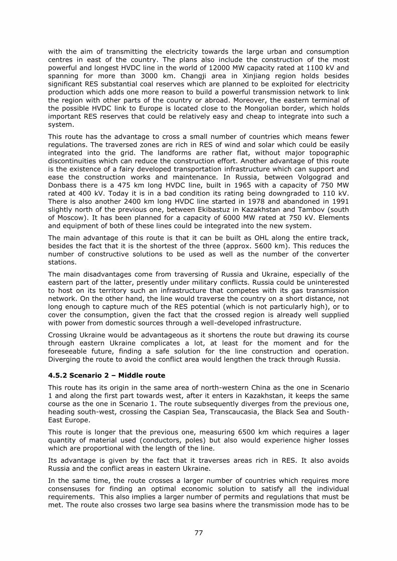
77
with the aim of transmitting the electricity towards the large urban and consumption
centres in east of the country. The plans also include the construction of the most
powerful and longest HVDC line in the world of 12000 MW capacity rated at 1100 kV and
spanning for more than 3000 km. Changji area in Xinjiang region holds besides
significant RES substantial coal reserves which are planned to be exploited for electricity
production which adds one more reason to build a powerful transmission network to link
the region with other parts of the country or abroad. Moreover, the eastern terminal of
the possible HVDC link to Europe is located close to the Mongolian border, which holds
important RES reserves that could be relatively easy and cheap to integrate into such a
system.
This route has the advantage to cross a small number of countries which means fewer
regulations. The traversed zones are rich in RES of wind and solar which could be easily
integrated into the grid. The landforms are rather flat, without major topographic
discontinuities which can reduce the construction effort. Another advantage of this route
is the existence of a fairy developed transportation infrastructure which can support and
ease the construction works and maintenance. In Russia, between Volgograd and
Donbass there is a 475 km long HVDC line, built in 1965 with a capacity of 750 MW
rated at 400 kV. Today it is in a bad condition its rating being downgraded to 110 kV.
There is also another 2400 km long HVDC line started in 1978 and abandoned in 1991
slightly north of the previous one, between Ekibastuz in Kazakhstan and Tambov (south
of Moscow). It has been planned for a capacity of 6000 MW rated at 750 kV. Elements
and equipment of both of these lines could be integrated into the new system.
The main advantage of this route is that it can be built as OHL along the entire track,
besides the fact that it is the shortest of the three (approx. 5600 km). This reduces the
number of constructive solutions to be used as well as the number of the converter
stations.
The main disadvantages come from traversing of Russia and Ukraine, especially of the
eastern part of the latter, presently under military conflicts. Russia could be uninterested
to host on its territory such an infrastructure that competes with its gas transmission
network. On the other hand, the line would traverse the country on a short distance, not
long enough to capture much of the RES potential (which is not particularly high), or to
cover the consumption, given the fact that the crossed region is already well supplied
with power from domestic sources through a well-developed infrastructure.
Crossing Ukraine would be advantageous as it shortens the route but drawing its course
through eastern Ukraine complicates a lot, at least for the moment and for the
foreseeable future, finding a safe solution for the line construction and operation.
Diverging the route to avoid the conflict area would lengthen the track through Russia.
4.5.2 Scenario 2 – Middle route
This route has its origin in the same area of north-western China as the one in Scenario
1 and along the first part towards west, after it enters in Kazakhstan, it keeps the same
course as the one in Scenario 1. The route subsequently diverges from the previous one,
heading south-west, crossing the Caspian Sea, Transcaucasia, the Black Sea and South-
East Europe.
This route is longer that the previous one, measuring 6500 km which requires a lager
quantity of material used (conductors, poles) but also would experience higher losses
which are proportional with the length of the line.
Its advantage is given by the fact that it traverses areas rich in RES. It also avoids
Russia and the conflict areas in eastern Ukraine.
In the same time, the route crosses a larger number of countries which requires more
consensuses for finding an optimal economic solution to satisfy all the individual
requirements. This also implies a larger number of permits and regulations that must be
met. The route also crosses two large sea basins where the transmission mode has to be
78
changed from OHL to submarine cable. This entails the construction of more conversion
stations (at least two for each sea) which on top of the increasing the cost would also
heighten the losses. If the nowadays state-of-art in power transmission is represented
by the 12000 MW capacity lines rated at 1100 kV, for the submarine power cables these
values are much lower (at around 20%) and even if we count that in close future these
values would increase it will still exist a significant gap between the two transmission
modes. This disparity induces a break in the attempt to keep constant the technical
parameters while crossing different environments. The OHL line would have to be
continued with 4-5 parallel submarine cables in order to keep the capacity constant
which will increase very much the cost of the investment.
The route crosses areas with various degrees of inhabitation or power infrastructure
development. East of the Caspian Sea the route crosses large steppe areas, sparsely
populated with a weak-developed power infrastructure. In the meantime, the wind
potential and partly the solar one are the highest. The Caspian Sea is rich in oil and gas
reserves intensively exploited and crossed by a dense network of submarine oil and gas
pipes. Transcaucasia has a rougher relief that requires the use of more elaborated and
more costly technical solutions. The area is relatively dense populated however without
any important RES. The Black Sea would be crossed along its longer axis with frequent
depths beyond 1500 m. On its western side the high wind potential is partly used.
4.5.3 Scenario 3 – South route
This route crosses the Asian continent through its southern expanse, avoiding the bulky
mountainous mass and high plateaus in western China. It has several advantages which
make it attractive but along the route there are a series of natural and societal
limitations which can be surpassed with higher costs.
Firstly, it is the longest one out of the three considered with more than 8600 km with at
least 2000 km longer than the central one and with almost 3000 km more than the
northern one. This translates into a larger quantity of material used for conductors,
pillars and other equipment as well as into an increase of losses due to longer line. The
route crosses seven countries (the number can vary by adjusting the path) which mean
a higher number of various requirements needed in order to obtain the permits which
further translates into more time needed or additional costs. Also, the route crosses
different natural environments and climates which require imagining various technical
solutions that make the designing more soliciting.
The route starts, in contrast with the previous ones, in the mountainous zone in
southern China, rich in hydropower resources already used or planned to be used in
close future. China has already built in the area a series of high capacity HVDC lines
(6400 MW, 800 kV) towards the big consumer centres in east (Shanghai) and south
(Guangdong, Shenzhen). The route continues westward crossing the mountainous zone
in northern Myanmar, crosses India from east to west passing further westward through
Pakistan, Afghanistan, Iran and Turkey through a series of plateaus traversed by deep
valleys.
Along the route, the neighbouring areas offer a rich and varied RES potential (wind,
solar, hydro). In China the hydropower potential is huge and its exploitation has already
begun. The northern mountainous area of Myanmar has a high unused hydropower
potential and the same is true for the southern fringes of Himalaya Mountains in India,
Nepal and Bhutan. Only in India it is partly exploited. The western half of the route
crosses arid zones where the main resources are the sun and partly the wind. This part
is also the roughest in terms of topography with an alternation of high arid plateaus
crossed by mountain ridges and deep valleys which require complex technical solutions.
In the meantime, this route requires only OHL to be used, without the need to cross
large water bodies, which dampens somewhat the length disadvantage.
On the eastern side of the route, in China and India, but not Myanmar, the power grid is
relatively well-developed, even dense in India, where several existing HVDC lines
79
superimpose the route’s path. Conversely, in western Pakistan, Afghanistan and eastern
Iran the power grid is patchy, disconnected from the main trunk and with the higher
voltages weak represented. In northwest Iran and Turkey the power grid is denser with
higher voltage lines present in large number. The development of the power grid offers
an image of the population distribution and of the intensity of the economic activity so
that for the areas with a developed power grid correspond dense populated areas and a
high power demand (present abut also in perspective).
The advantage of this route is done by the fact that a couple of countries (China and
India) have already a solid experience in designing and building HVDC systems, several
of them being aligned along the route. The high density population with perspectives of
economic improvement in future located along the eastern half of the route can also be
counted as an advantage since it determines an increase in consumption and hence the
need for infrastructure upgrading and the search for new alternative sources of energy.
The route offers also a real chance for economic integration for regions considered until
recently as marginal but which start to play an important strategic role in the equation of
the regional RES resources: Myanmar, Afghanistan and Iran.
4.6 DC infrastructure in target countries
The grid power in Central Asia is dominated by few major systems belonging to the
largest countries covering the realm: Russia and the former USSR countries, China and
India.
Some countries taking part in CIS (Commonwealth of Independent States) operate their
national power grids within a unified wide area synchronous system called UPS/IPS
(Unified Power System / Integrated Power System). It has a common mode of operation
and centralized supervisory control. UPS represents the part of the system covering
Russia and it is made up of six regional transmission operators. IPS comprises few
neighbouring countries (Ukraine, Kazakhstan, Kyrgyzstan, Belarus, Azerbaijan,
Tajikistan, Georgia, Moldova and Mongolia) whose systems run and are managed
technically unitary. UPS/IPS spans nine time zones, includes more than 650 power plants
with almost 300 GW installed capacity and servers 280 million clients.
The power grid in Soviet Central Asia was designed and developed during 1950s with
little to none consideration to former USSR internal borders. It was meant as a unitary
grid to serve a larger area by connecting generation with consumption irrespective to the
borders. This setting became a liability after the former USSR republics became
independent with each new country trying to decrease the energetic dependency by
reshaping its power grid. New lines appear while old ties are cut down as it is the case
with Kyrgyzstan and Kazakhstan.
As presented in countries’ analysis the power grid is found in various degrees of
development from rather developed in parts of India and China (where there are also
HVDC systems in place) to insufficient developed, patchy, insular/isolated or non-
existent in southern Afghanistan. With few exceptions the backbone of the
regional/national power grids is represented by the 220/330 kV AC lines which have to
cope with the continuous growing demand. The overloading causes breakdowns which
can be common in some areas. Although in the last decade there were huge progresses
in delivering electricity to (virtually) all the people, there are regions where the access of
electricity is still in low percentage. The distribution network is not always resilient
enough to power shocks and can often fail.
China has a decent power grid which is continuing expanding and upgraded. The huge
solar and wind potential in the north-west is partly harnessed but lately the installing of
new capacities had to be halted due to the incapacity of the grid to take over and
transmit further the electricity produced. This affects mainly the north-west province of
Xinjiang. The ex-Soviet Central Asian countries have also a decent power grid at least in
populated places. Due to orographic barriers the power grids of Tajikistan and
Kyrgyzstan are missing continuity and rely on neighbours support.
80
Myanmar has an insufficient transmission power grid, especially in the northern part,
where the hydro potential could be tapped. India’s power grid is reasonably well
developed in the northern part beneficing of the several high capacity HVDC lines. The
power grid of Pakistan is relatively well developed in the populated areas but weak in the
mountains, which is also the case for Afghanistan, where a proper and unitary grid lacks.
Iran and Turkey display both a well-developed and strong power grid, except the eastern
part of Iran dominated by deserts.
Once with the technological advance during the last years the HVDC systems are more
and more used. Even if ultimately they are used to transmit electricity to the large
consumption centres, the decision to build them goes down to the local conditions and
needs. In Europe for example the HVDC systems are built and used for balancing the
regional fluctuations between generation and consumption as well as to connect the off
shore wind farms to the grid on shore. In Asia on the other side, the HVDC systems were
built to carry unidirectional large quantities of electricity from powerful generators to
large growing consumption centres.
The only countries in continental Asia that have HVDC systems are China and India.
China is world leader by counting the number of HVDC systems built or being in different
stages of construction or planning. China holds its own expertise in planning and
designing as well as manufacture capacities for the whole range of equipment needed. It
will also build the systems with the highest rated voltage (1100 kV) and transmission
capacity (12000 MW). The main HVDC line start at the hydropower plants in western
China and head the major consumption centres in east (Beijing, Shanghai) and south
(Guangdong, Shenzhen).
China also represents the largest HVDC market in the world. Initially the first systems
used ABB and Siemens technology which allowed transferring their technology to the
local companies. Alstom refused to do so and it has been initially excluded, but later on
it entered in further negotiations. Nowadays the HVDC technology and the chain of
supply is almost (85-90%) entirely Chinese, the country being able to develop projects
abroad. The first projects will most probably be developed in South America, Africa or
Middle East. The markets in Europe or North America are hard to enter due to lack of
experience and protectionism. SGCC has won the bid for a HVDC system in Brazil (Belo
Monte Hydropower UHV Transmission Project, 11 GW, ± 800kV, consortium 51% SGCC,
49% Eletrobras) (Bowden, 2013).
Building new power transmission lines is costly and it can meet the resistance or refusal
of the traversed communities or even the lack of space.
A solution which can be taken into consideration as an alternative to building new lines is
the conversion of HVAC lines into HVDC, where the transmission is done along long
distances and without many connections with secondary branches. In this case to costs
would involve only the converter stations and adapting the lines. A second advantage
resulted from conversion would be the reduction of the number of the transmission lines
and also of the quantity of material used (pillars, conductors). By using a reduced
number of conductors a narrower ROW can be deigned and used with freeing spaces
along the corridor which might carry economic importance in densely populated zones.
An alternative solution to the one presented above, when it is not possible the line
conversion, is using in common the ROWs. This would facilitate and minimize the cost of
interconnecting the HVDC lines with the AC grids. Moreover, by using a common corridor
the impact of creating a new transmission couloir is minimized since it is easier to accept
an extension of an existing corridor than creating a new one.
Such a long line requires a complex solution in design and construction. It must allow
the power to be fed at different points along the line and also the discharge at the
consumption points. Such a situation could be solved by envisaging a multi-terminal
system.
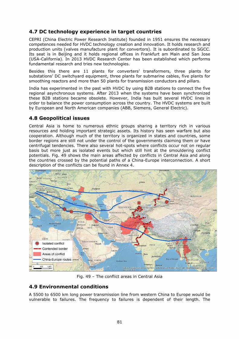
81
4.7 DC technology experience in target countries
CEPRI (China Electric Power Research Institute) founded in 1951 ensures the necessary
competences needed for HVDC technology creation and innovation. It holds research and
production units (valves manufacture plant for convertors). It is subordinated to SGCC.
Its seat is in Beijing and it holds regional offices in Frankfurt am Main and San Jose
(USA-California). In 2013 HVDC Research Center has been established which performs
fundamental research and tries new technologies.
Besides this there are 11 plants for converters’ transformers, three plants for
substations’ DC switchyard equipment, three plants for submarine cables, five plants for
smoothing reactors and more than 50 plants for transmission conductors and pillars.
India has experimented in the past with HVDC by using B2B stations to connect the five
regional asynchronous systems. After 2013 when the systems have been synchronized
these B2B stations became obsolete. However, India has built several HVDC lines in
order to balance the power consumption across the country. The HVDC systems are built
by European and North American companies (ABB, Siemens, General Electric).
4.8 Geopolitical issues
Central Asia is home to numerous ethnic groups sharing a territory rich in various
resources and holding important strategic assets. Its history has seen warfare but also
cooperation. Although much of the territory is organized in states and countries, some
border regions are still not under the control of the governments claiming them or have
centrifugal tendencies. There also several hot-spots where conflicts occur not on regular
basis but more just as isolated events but which still hint at the smouldering conflict
potentials. Fig. 49 shows the main areas affected by conflicts in Central Asia and along
the countries crossed by the potential paths of a China-Europe interconnection. A short
description of the conflicts can be found in Annex 4.
Fig. 49 – The conflict areas in Central Asia
4.9 Environmental conditions
A 5500 to 6500 km long power transmission line from western China to Europe would be
vulnerable to failures. The frequency to failures is dependent of their length. The
82
concerned zone crossed by the route(s) stretches over a wide area with various climates
and natural and societal environments which multiplies the causes for failures.
For every type of environment the designed equipment must withstand the implied
conditions. Experience can be derived from equipment installed in similar conditions
elsewhere in the world. HVDC systems have been installed in almost every type of
environment found along the proposed routes, from high altitude mountains to deserts
and humid zones. However, special attention must be paid to the environmental
conditions in arid areas affected by retreated or retreating lakes which leave salty
surfaces behind. The salty crystals blown by the wind could interfere with the good
functioning of the HVDC equipment so special insulation measures must be taken into
account.
4.10 Estimated cost
The cost of HVDC infrastructure is usually high, in the range of hundreds of millions of
euros or US dollars, which is a big commitment for the involved entity/s. The investment
costs are usually paid back in decades under favourable economic conditions.
As mentioned earlier, the largest share in the total cost goes to converter stations. For a
multi-terminal system, the number of converter stations may vary according to the
complexity and the length of the line. All crossed countries would probably want to be
able to both feed in and take out electricity form the system which requires extended
capabilities for all the converter stations along the line which increase their cost. The
cost for a standard convertor station is around €350-400 million but for the more
powerful one needed for such a project is much higher, double by keeping the size and
parameters values in check.
The line cost for such a length could also be considerable. It varies a lot according to the
terrain conditions and environment (land or submarine). The cost for the most
favourable terrain to build is around €1,8-2 million /km and three to four times higher
for submarine power cables.
Obtaining the permits also involves costs as buying the rights for using the ROWs does.
Since these vary largely from country to country they are hard to estimate beforehand.
For the shortest route (Scenario 1, north) crossing six countries requiring at least six
converter stations, the cost for converter stations could reach €4-5 billion while for the
line €11 billion.
The middle route (Scenario 2) involves 8-10 countries to be crossed which raise the cost
for the converter stations to €6-8 billion and for the line to €10 billion for OHL segments.
An additional hard to estimate cost is attached to submarine segments but they will
probably add not less than €5-6 billion.
The longest route (Scenario 3, south) crosses 11-13 countries. The converter stations’
cost would be around €7,5-9 billion and the lines’ €17 billion.
83
Conclusions
The power consumption and demand will increase in future with the population and
economic growth despite the energy efficiency measures taken. As the conventional
fossil fuels reserves diminish and become more expensive to extract the demand must
be covered from alternative sources. The global climate change experienced in the last
decades which has (at least partly) a human source is another reason to turn towards
renewable energy sources. These are however climate and weather dependent. Their
geographical distribution follows the major climates and natural environments yielding
higher efficiency where favourable conditions are met. Central Asia is a vast continental
area with a multitude of climates and environments which exposes over large areas
favourable conditions for high RES potentials.
In 2016 China has launched the initiative “Belt and Road Initiative” which aims at
making China a prime actor in the world economy. It addresses the Asian, African and
partly European states and consists in financial support or participation in joint
programmes aiming at building infrastructure. Among these a proposal for building an
HVDC interconnection to transmit “clean” electricity to Europe has been advanced.
Given the challenges of finding a steady source of clean electricity to meet the ever
increasing power demand of Europe the moment to study and consider the advent of
such an interconnection is just right.
The technology advances in the last decade in the field of HVDC transmission brought
the state-of-the-art at the level where such an infrastructure is technically possible to be
built and operated. The numerous examples around the world, especially coming from
Europe, United States and China where solid and powerful systems have been built,
show that the technology is mature and well established as common way of transmitting
large quantities of electricity over long distances. The capacities and ratings are high
enough to withstand long distance associated losses maintain a high efficiency. Although
this is valid for overhead lines (OHL) in case the system would imply the use of
submarine cables the technical parameters of the latter are not at pair with the former.
This requires either lowering the capacity for the concerned segments or using parallel
cables to keep it constant but which would increase the costs.
Multi-terminal configuration would fit best the scope, length and complexity required by
such a system. The few cases of multi-terminal interconnection built until now do not
reach the complexity for a China to Europe interconnection so more studies and trials
should be devoted to develop this configuration to the scope of the project.
The report studied three potential paths for the interconnection each offering advantages
and drawbacks. The path should be chosen in a way to maximize the RES generation
yielding, the trade benefits and the efficiency in operation. Conflict areas exist along the
proposed routes and should be avoided.
84
Bibliography
ALHASAN Systems. (2011-2012). Solar Radiation Map Pakistan. Retrieved from ALHASAN Systems
Private Limited: http://www.alhasan.com/maps/solar-radiation-map-pakistan-0
Ardelean, M., & Minnebo, P. (2015). HVDC Submarine Power Cables in the World. Joint Research
Centre.
Asia Pacific Energy Research Centre. (2015). Electric power grid interconnections in Northeast Asia.
Tokyo: Asia Pacific Energy Research Centre. Retrieved from
http://aperc.ieej.or.jp/file/2015/11/27/FinalReport-APERC-
Electric_Power_Grid_Interconnection_in_NEA.pdf
Asian Development Bank. (2012). Wind Energy Future in Asia. Retrieved from https://i-
windenergy.com/sites/i-
windenergy.com/files/Wind%20Future%20in%20Asia%20Report%20(Final)Updtated23Aug1
2_0.pdf
Asian Development Bank. (2015). Assessment of power sector reforms in Georgia. Manila: Asian
Development Bank. Retrieved from https://www.adb.org/sites/default/files/institutional-
document/161067/georgia-psr-report.pdf
Bowden, J. (2013, 06 20). China takes HVDC to new level. Retrieved from Power Engineering
International: http://www.powerengineeringint.com/articles/print/volume-21/issue-
6/special-focus-hvdc/china-takes-hvdc-to-new-level.html
Business Association of Georgia. (2016). Electricity sector: overview. Tbilisi: 06. Retrieved from
http://bag.ge/file.helix?i=427e322d-a7ea-48fc-a283-d27ee04ac0a2&r=P
Chatzivasileiadis, S., Ernst, D., & Andersson, G. (2013). The Global Grid. Renewable Energy, 57, pp.
372-383.
Elliot, D., Schwartz, M., Scott, G., Haymes, S., Heimiller, D., & George, R. (2001). Wind energy
resource. Atlas of Mongolia. NREL. Retrieved from
http://130.226.56.150/extra/web_docs/windmaps/mongolia_wind_atlas.pdf
Energy Charter Secretariat. (2011). Azerbaijan. Follow-up in-depth review of the investment climate
and market structure in the energy sector. Brussels: Energy Charter Secretariat. Retrieved
from http://www.energycharter.org/fileadmin/DocumentsMedia/ICMS/ICMS-
Azerbaijan_2011_en.pdf
European Environmental Agency. (2009, 11 12). Caspian Sea physiography (depth distribution and
main currents). Retrieved from European Environmental Agency:
https://www.eea.europa.eu/data-and-maps/figures/caspian-sea-physiography-depth-
distribution-and-main-currents
Fichtner. (2013). Update of the Power Sector Master Plan of Azerbaijan 2013 - 2025. Stuttgart:
Fichtner. Retrieved from http://www.inogate.org/documents/3_FICHT-11527706-v2-
Final_Report_Azerbaijan.pdf
85
FICHTNER GmbH & Co. KG. (2013). Islamic Republic of Afghanistan: Power Sector Master Plan.
Stuttgart: Asian Development Bank. Retrieved from
https://www.adb.org/sites/default/files/project-document/76570/43497-012-afg-tacr.pdf
Fulli, G., Purvins, A., Rüberg, S., L'Abbate, A., & Migliavacca, G. (2011). Evolutions and Challenges
towards a Potential Pan-European HVAC/HVDC SuperGrid. The Electric Power System of the
Future - Integrating supergrids and microgrids. Bologna.
General Electricity Authority. (2017). Power Sector. New Delhi. Retrieved from
http://www.cea.nic.in/reports/monthly/executivesummary/2017/exe_summary-01.pdf
Ghalib, A. (2017, 1 2). Afghanistan’s Energy Sector Development Plans. Retrieved from Turkiye
Cumuhuriyeti Ekonomi Bakanligi:
https://www.ekonomi.gov.tr/portal/content/conn/UCM/uuid/dDocName:EK-
236901;jsessionid=P719f__iFOsLE0aXq5A_u_3qDWBBrhpp9Ee6T6pEGSORQQjrfJnH!-
1930188290
Global Wind Energy Council. (2016). Global Wind Report. Annual market update 2016. Brussels.
Hossain, J. (2014). World Wind Resource Assessment Report. Bonn: World Wind Energy Association.
International Energy Agency. (2011). Technology roadmap. China wind energy development
roadmap 2050. International Energy Agency. Retrieved from
https://www.iea.org/publications/freepublications/publication/china_wind.pdf
KEGOC. (2017, 06 06). KEGOC - The company. Retrieved from http://www.kegoc.kz/en/company
Khosroshahi, K., Jadid, S., & Shahidehpour, M. (2009). Electric Power Restructuring in Iran:
Achievements and Challenges. The Electricity Journal, 22(2), 74-83. Retrieved from
http://www.sciencedirect.com/science/article/pii/S1040619009000256
Kochnakyan, A., Khosla, S., Buranov, I., Hofer, K., Hankinson, D., & Finn, J. (2013). Uzbekistan
Energy/Power Sector Issues Note. Washington DC: The World Bank. Retrieved from
http://www.ekonomi.gov.tr/portal/content/conn/UCM/uuid/dDocName:EK-203124
KPMG. (2016, 12). Power sector overview Georgia. Retrieved from KPMG International:
https://home.kpmg.com/content/dam/kpmg/ge/pdf/2017/Georgia%20-
%20Power%20Sector%20Overview.pdf
L'Abbate, A., & Fulli, G. (2010). Modeling and application of VSC-HVDC in the European transmission
system. International Journal of Inovations in Energy Systems and Power, 5(1), 8-16.
Liu, Z. (2013). Electric power and energy in China. Singapore: Wiley.
Liu, Z. (2015). Ultra-High Voltage AC/DC Grids. Waltham: Chia Electric Power Press.
Liu, Z., Chen, G., Guan, X., Wang, Q., & He, W. (2016). A Concept Discussion on Northeast Asia Power
Grid Interconnection. CSEE Journal of power and energy systems, 87-93. Retrieved from
http://ieeexplore.ieee.org/stamp/stamp.jsp?arnumber=7785872
86
Malik, N. (2011). Energy resources in Afghanistan and measures to improve for sustainable
development. Journal of Sustainable Energy, 2(4). Retrieved from http://www.energy-
cie.ro/archives/2011/2.25-afghanistan-energy-by-nadeem-malik.pdf
Nam, K.-Y., Cham, M., & Halili, P. (2015, 10). Power sector development in Myanmar. (A. D. Bank,
Ed.) ADB Economics Working Paper Series(460). Retrieved from
http://themimu.info/sites/themimu.info/files/documents/Ref_Doc_Power_Sector_Develop
ment_ADB_Oct2015.pdf
Padiyar, K. (2011). HVDC Power Transmission Systems. Tunbridge Wells: New Academic Science.
Pletka, R., Khangura, J., Rawlins, A., Waldren, E., & Wilson, D. (2014). Capital costs for tranmission
and substations. Western Electricity Coordinating Council. Retrieved from
https://www.wecc.biz/Reliability/2014_TEPPC_Transmission_CapCost_Report_B+V.pdf
Putz, C. (2015, 09 01). Kyrgyzstan Declares Energy Independence. Retrieved from The Diplomat:
http://thediplomat.com/2015/09/kyrgyzstan-declares-energy-independence/
Radio Free Europe/Radio Liberty. (2009, 12 01). Uzbekistan Withdrawing From Regional Power Grid.
Retrieved from Radio Free Europe/Radio Liberty:
https://www.rferl.org/a/Uzbekistan_Withdrawing_From_Regional_Power_Grid/1892220.ht
ml
Riesen, J. (2010, 06 13). U.S. Identifies Vast Mineral Riches in Afghanistan. Retrieved from New York
Times: http://www.nytimes.com/2010/06/14/world/asia/14minerals.html
Siemens. (2013, 12 13). Georgia now exporting green energy to Turkey. Retrieved from Siemens
Global Website: https://www.siemens.com/press/en/feature/2013/energy/2013-12-
blacksea.php
Siemens. (2015, 04 16). HVDC link between France and Spain: milestone on the road towards the
single European energy market. Retrieved from
http://www.siemens.com/press/en/events/2015/energymanagement/2015-04-
Inelfe.php?content[]=EM
U.S. Department of Commerce. (2016, 12 08). Kazakhstan - Electrical Power Generation. Retrieved
from www.export.gov: https://www.export.gov/article?id=Kazakhstan-Electrical-Power-
Generation
US Department of Commerce. (2015, 10 03). Tajikistan – Power Generation and Distribution.
Retrieved from export.gov: https://www.export.gov/article?id=Tajikistan-Power-Generation-
and-Distribution
Yousefi, G., Kaviri, S., Latify, M., & Rahmati, I. (2017). Electricity industry restructuring in Iran. Energy
Policy, 212-226.
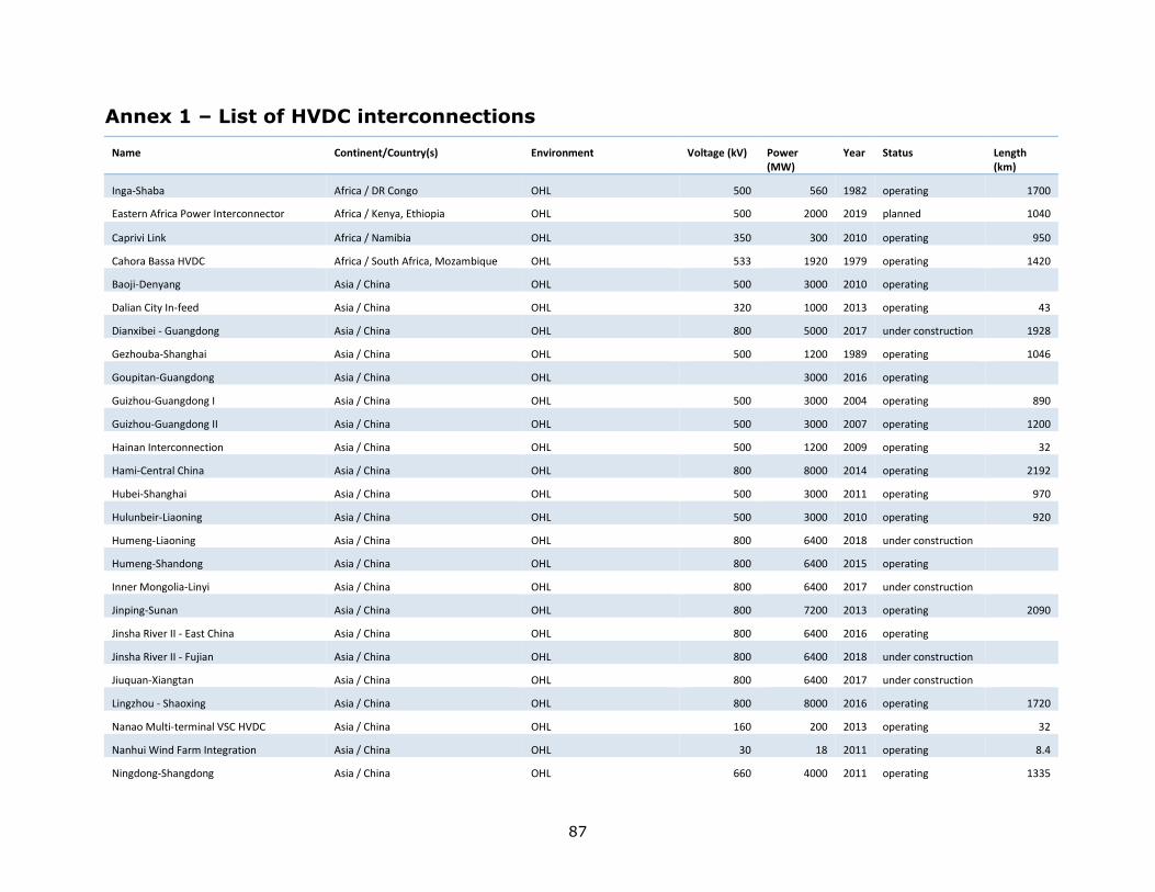
87
Annex 1 – List of HVDC interconnections
Name Continent/Country(s) Environment Voltage (kV) Power (MW)
Year Status Length (km)
Inga-Shaba Africa / DR Congo OHL 500 560 1982 operating 1700
Eastern Africa Power Interconnector Africa / Kenya, Ethiopia OHL 500 2000 2019 planned 1040
Caprivi Link Africa / Namibia OHL 350 300 2010 operating 950
Cahora Bassa HVDC Africa / South Africa, Mozambique OHL 533 1920 1979 operating 1420
Baoji-Denyang Asia / China OHL 500 3000 2010 operating
Dalian City In-feed Asia / China OHL 320 1000 2013 operating 43
Dianxibei - Guangdong Asia / China OHL 800 5000 2017 under construction 1928
Gezhouba-Shanghai Asia / China OHL 500 1200 1989 operating 1046
Goupitan-Guangdong Asia / China OHL 3000 2016 operating
Guizhou-Guangdong I Asia / China OHL 500 3000 2004 operating 890
Guizhou-Guangdong II Asia / China OHL 500 3000 2007 operating 1200
Hainan Interconnection Asia / China OHL 500 1200 2009 operating 32
Hami-Central China Asia / China OHL 800 8000 2014 operating 2192
Hubei-Shanghai Asia / China OHL 500 3000 2011 operating 970
Hulunbeir-Liaoning Asia / China OHL 500 3000 2010 operating 920
Humeng-Liaoning Asia / China OHL 800 6400 2018 under construction
Humeng-Shandong Asia / China OHL 800 6400 2015 operating
Inner Mongolia-Linyi Asia / China OHL 800 6400 2017 under construction
Jinping-Sunan Asia / China OHL 800 7200 2013 operating 2090
Jinsha River II - East China Asia / China OHL 800 6400 2016 operating
Jinsha River II - Fujian Asia / China OHL 800 6400 2018 under construction
Jiuquan-Xiangtan Asia / China OHL 800 6400 2017 under construction
Lingzhou - Shaoxing Asia / China OHL 800 8000 2016 operating 1720
Nanao Multi-terminal VSC HVDC Asia / China OHL 160 200 2013 operating 32
Nanhui Wind Farm Integration Asia / China OHL 30 18 2011 operating 8.4
Ningdong-Shangdong Asia / China OHL 660 4000 2011 operating 1335
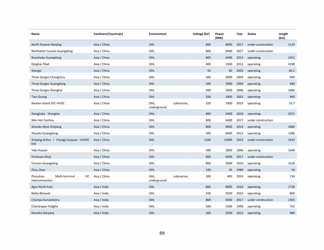
88
Name Continent/Country(s) Environment Voltage (kV) Power (MW)
Year Status Length (km)
North Shaanxi-Nanjing Asia / China OHL 800 8000 2017 under construction 1119
Northwest Yunnan-Guangdong Asia / China OHL 800 6400 2017 under construction
Nuozhadu-Guangdong Asia / China OHL 800 6400 2015 operating 1451
Qinghai-Tibet Asia / China OHL 400 1500 2012 operating 1038
Shengsi Asia / China OHL 50 60 2002 operating 66.2
Three Gorges-Changzhou Asia / China OHL 500 3000 2004 operating 940
Three Gorges-Guangdong Asia / China OHL 500 3000 2004 operating 940
Three Gorges-Shanghai Asia / China OHL 500 3000 2006 operating 1060
Tian-Guang Asia / China OHL 500 1800 2001 operating 960
Xiamen Island VSC-HVDC Asia / China OHL, submarine, underground
320 1000 2015 operating 10.7
Xiangjiaba - Shanghai Asia / China OHL 800 6400 2010 operating 2071
Xilin Hot-Taizhou Asia / China OHL 800 6400 2017 under construction
Xiluodo-West Zhejiang Asia / China OHL 800 8000 2014 operating 1680
Xiluodu-Guangdong Asia / China OHL 500 6400 2013 operating 1286
Xinjiang-Anhui / Changji-Guquan UHVDC link
Asia / China OHL 1100 12000 2019 under construction 3333
Yidu-Huaxin Asia / China OHL 500 3000 2006 operating 1048
Yinchuan-Zhuji Asia / China OHL 800 6400 2017 under construction
Yunnan-Guangdong Asia / China OHL 800 5000 2010 operating 1418
Zhou Shan Asia / China OHL 100 50 1989 operating 54
Zhoushan Multi-terminal DC Interconnection
Asia / China OHL, submarine, underground
200 400 2014 operating 134
Agra North-East Asia / India OHL 800 8000 2016 operating 1728
Ballia-Bhiwadi Asia / India OHL 500 2500 2010 operating 800
Champa-Kurukshetra Asia / India OHL 800 6000 2017 under construction 1365
Chandrapur-Padghe Asia / India OHL 500 1500 1999 operating 752
Mundra-Haryana Asia / India OHL 500 2500 2012 operating 989
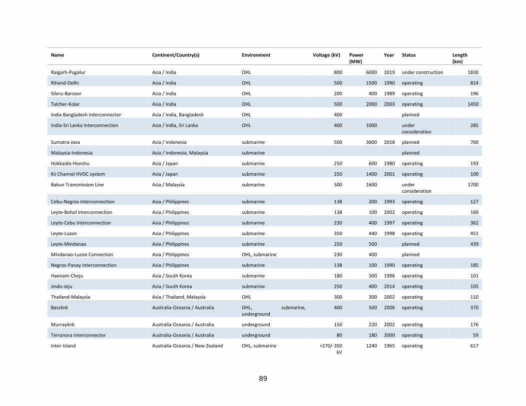
89
Name Continent/Country(s) Environment Voltage (kV) Power (MW)
Year Status Length (km)
Raigarh-Pugalur Asia / India OHL 800 6000 2019 under construction 1830
Rihand-Delhi Asia / India OHL 500 1500 1990 operating 814
Sileru-Barsoor Asia / India OHL 200 400 1989 operating 196
Talcher-Kolar Asia / India OHL 500 2000 2003 operating 1450
India Bangladesh Interconnector Asia / India, Bangladesh OHL 400 planned
India-Sri Lanka Interconnection Asia / India, Sri Lanka OHL 400 1000 under consideration
285
Sumatra-Java Asia / Indonesia submarine 500 3000 2018 planned 700
Malaysia-Indonesia Asia / Indonesia, Malaysia submarine planned
Hokkaido-Honshu Asia / Japan submarine 250 600 1980 operating 193
Kii Channel HVDC system Asia / Japan submarine 250 1400 2001 operating 100
Bakun Transmission Line Asia / Malaysia submarine 500 1600 under consideration
1700
Cebu-Negros Interconnection Asia / Philippines submarine 138 200 1993 operating 127
Leyte-Bohol Interconnection Asia / Philippines submarine 138 100 2002 operating 169
Leyte-Cebu Interconnection Asia / Philippines submarine 230 400 1997 operating 362
Leyte-Luzon Asia / Philippines submarine 350 440 1998 operating 451
Leyte-Mindanao Asia / Philippines submarine 250 500 planned 439
Mindanao-Luzon Connection Asia / Philippines OHL, submarine 230 400 planned
Negros-Panay Interconnection Asia / Philippines submarine 138 100 1990 operating 185
Haenam-Cheju Asia / South Korea submarine 180 300 1996 operating 101
Jindo-Jeju Asia / South Korea submarine 250 400 2014 operating 105
Thailand-Malaysia Asia / Thailand, Malaysia OHL 300 300 2002 operating 110
Basslink Australia-Oceania / Australia OHL, submarine, underground
400 500 2006 operating 370
Murraylink Australia-Oceania / Australia underground 150 220 2002 operating 176
Terranora interconnector Australia-Oceania / Australia underground 80 180 2000 operating 59
Inter-Island Australia-Oceania / New Zealand OHL, submarine +270/-350 kV
1240 1965 operating 617
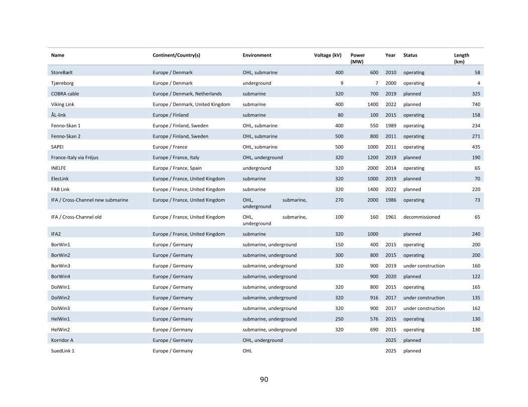
90
Name Continent/Country(s) Environment Voltage (kV) Power (MW)
Year Status Length (km)
StoreBælt Europe / Denmark OHL, submarine 400 600 2010 operating 58
Tjæreborg Europe / Denmark underground 9 7 2000 operating 4
COBRA cable Europe / Denmark, Netherlands submarine 320 700 2019 planned 325
Viking Link Europe / Denmark, United Kingdom submarine 400 1400 2022 planned 740
ÅL-link Europe / Finland submarine 80 100 2015 operating 158
Fenno-Skan 1 Europe / Finland, Sweden OHL, submarine 400 550 1989 operating 234
Fenno-Skan 2 Europe / Finland, Sweden OHL, submarine 500 800 2011 operating 271
SAPEI Europe / France OHL, submarine 500 1000 2011 operating 435
France-Italy via Fréjus Europe / France, Italy OHL, underground 320 1200 2019 planned 190
INELFE Europe / France, Spain underground 320 2000 2014 operating 65
ElecLink Europe / France, United Kingdom submarine 320 1000 2019 planned 70
FAB Link Europe / France, United Kingdom submarine 320 1400 2022 planned 220
IFA / Cross-Channel new submarine Europe / France, United Kingdom OHL, submarine, underground
270 2000 1986 operating 73
IFA / Cross-Channel old Europe / France, United Kingdom OHL, submarine, underground
100 160 1961 decommissioned 65
IFA2 Europe / France, United Kingdom submarine 320 1000 planned 240
BorWin1 Europe / Germany submarine, underground 150 400 2015 operating 200
BorWin2 Europe / Germany submarine, underground 300 800 2015 operating 200
BorWin3 Europe / Germany submarine, underground 320 900 2019 under construction 160
BorWin4 Europe / Germany submarine, underground 900 2020 planned 122
DolWin1 Europe / Germany submarine, underground 320 800 2015 operating 165
DolWin2 Europe / Germany submarine, underground 320 916 2017 under construction 135
DolWin3 Europe / Germany submarine, underground 320 900 2017 under construction 162
HelWin1 Europe / Germany submarine, underground 250 576 2015 operating 130
HelWin2 Europe / Germany submarine, underground 320 690 2015 operating 130
Korridor A Europe / Germany OHL, underground 2025 planned
SuedLink 1 Europe / Germany OHL 2025 planned
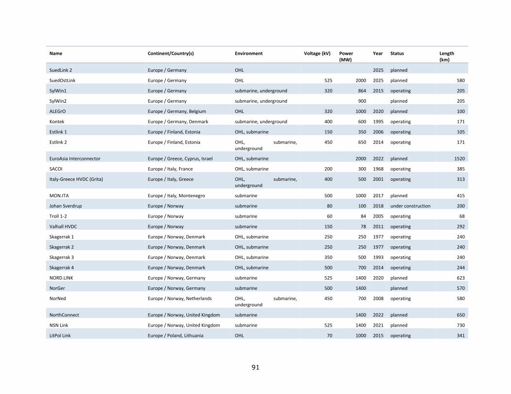
91
Name Continent/Country(s) Environment Voltage (kV) Power (MW)
Year Status Length (km)
SuedLink 2 Europe / Germany OHL 2025 planned
SuedOstLink Europe / Germany OHL 525 2000 2025 planned 580
SylWin1 Europe / Germany submarine, underground 320 864 2015 operating 205
SylWin2 Europe / Germany submarine, underground 900 planned 205
ALEGrO Europe / Germany, Belgium OHL 320 1000 2020 planned 100
Kontek Europe / Germany, Denmark submarine, underground 400 600 1995 operating 171
Estlink 1 Europe / Finland, Estonia OHL, submarine 150 350 2006 operating 105
Estlink 2 Europe / Finland, Estonia OHL, submarine, underground
450 650 2014 operating 171
EuroAsia Interconnector Europe / Greece, Cyprus, Israel OHL, submarine 2000 2022 planned 1520
SACOI Europe / Italy, France OHL, submarine 200 300 1968 operating 385
Italy-Greece HVDC (Grita) Europe / Italy, Greece OHL, submarine, underground
400 500 2001 operating 313
MON.ITA Europe / Italy, Montenegro submarine 500 1000 2017 planned 415
Johan Sverdrup Europe / Norway submarine 80 100 2018 under construction 200
Troll 1-2 Europe / Norway submarine 60 84 2005 operating 68
Valhall HVDC Europe / Norway submarine 150 78 2011 operating 292
Skagerrak 1 Europe / Norway, Denmark OHL, submarine 250 250 1977 operating 240
Skagerrak 2 Europe / Norway, Denmark OHL, submarine 250 250 1977 operating 240
Skagerrak 3 Europe / Norway, Denmark OHL, submarine 350 500 1993 operating 240
Skagerrak 4 Europe / Norway, Denmark OHL, submarine 500 700 2014 operating 244
NORD.LINK Europe / Norway, Germany submarine 525 1400 2020 planned 623
NorGer Europe / Norway, Germany submarine 500 1400 planned 570
NorNed Europe / Norway, Netherlands OHL, submarine, underground
450 700 2008 operating 580
NorthConnect Europe / Norway, United Kingdom submarine 1400 2022 planned 650
NSN Link Europe / Norway, United Kingdom submarine 525 1400 2021 planned 730
LitPol Link Europe / Poland, Lithuania OHL 70 1000 2015 operating 341
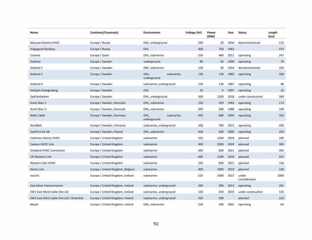
92
Name Continent/Country(s) Environment Voltage (kV) Power (MW)
Year Status Length (km)
Moscow-Kashira HVDC Europe / Russia OHL, underground 100 30 1950 decommissioned 125
Volgograd-Donbass Europe / Russia OHL 400 750 1965 475
Cometa Europe / Spain OHL, submarine 250 400 2011 operating 247
Gotland Europe / Sweden underground 80 50 1999 operating 70
Gotland 1 Europe / Sweden OHL, submarine 150 30 1954 decommissioned 103
Gotland 2 Europe / Sweden OHL, submarine, underground
150 130 1983 operating 100
Gotland 3 Europe / Sweden submarine, underground 150 130 1987 operating 98
Hellsjön-Grängesberg Europe / Sweden OHL 10 3 1997 operating 10
SydVästlänken Europe / Sweden OHL, underground 300 1200 2018 under construction 260
Konti-Skan 1 Europe / Sweden, Denmark OHL, submarine 250 350 1965 operating 173
Konti-Skan 2 Europe / Sweden, Denmark OHL, submarine 300 300 1988 operating 149
Baltic Cable Europe / Sweden, Germany OHL, submarine, underground
450 600 1994 operating 262
NordBalt Europe / Sweden, Lithuania submarine, underground 300 700 2015 operating 450
SwePol Link AB Europe / Sweden, Poland OHL, submarine 450 600 2000 operating 254
Caithness Moray HVDC Europe / United Kingdom submarine 320 1200 2018 planned 160
Eastern HVDC Link Europe / United Kingdom submarine 400 2000 2024 planned 305
Shetland HVDC Connection Europe / United Kingdom submarine 300 600 2021 planned 345
UK Western Link Europe / United Kingdom submarine 600 2200 2018 planned 422
Western Isles HVDC Europe / United Kingdom submarine 320 600 2021 planned 156
Nemo Link Europe / United Kingdom, Belgium submarine 400 1000 2019 planned 140
IceLink Europe / United Kingdom, Iceland submarine 525 1000 2027 under consideration
1000
East-West Interconnector Europe / United Kingdom, Ireland submarine, underground 200 500 2012 operating 261
EW1 East-West Cable One Ltd Europe / United Kingdom, Ireland submarine, underground 150 350 2019 under construction 135
EW2 East-West Cable One Ltd / Greenlink Europe / United Kingdom, Ireland submarine, underground 320 500 planned 210
Moyle Europe / United Kingdom, Ireland OHL, submarine 250 500 2001 operating 64
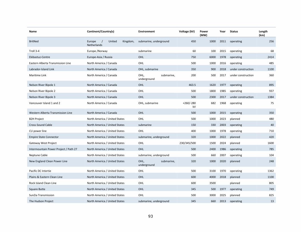
93
Name Continent/Country(s) Environment Voltage (kV) Power (MW)
Year Status Length (km)
BritNed Europe / United Kingdom, Netherlands
submarine, underground 450 1000 2011 operating 256
Troll 3-4 Europe /Norway submarine 60 100 2015 operating 68
Ekibastuz-Centre Europe-Asia / Russia OHL 750 6000 1978 operating 2414
Eastern Alberta Transmission Line North America / Canada OHL 500 1000 2016 operating 485
Labrador-Island Link North America / Canada OHL, submarine 350 900 2018 under construction 1100
Maritime Link North America / Canada OHL, submarine, underground
200 500 2017 under construction 360
Nelson River Bipole 1 North America / Canada OHL 463.5 1620 1977 operating 895
Nelson River Bipole 2 North America / Canada OHL 500 1800 1985 operating 937
Nelson River Bipole 3 North America / Canada OHL 500 2300 2017 under construction 1384
Vancouver Island 1 and 2 North America / Canada OHL, submarine +260/-280 kV
682 1968 operating 75
Western Alberta Transmission Line North America / Canada OHL 500 1000 2015 operating 350
B2H Project North America / United States OHL 500 1000 2023 planned 480
Cross-Sound Cable North America / United States submarine 150 330 2003 operating 40
CU power line North America / United States OHL 400 1000 1978 operating 710
Empire State Connector North America / United States submarine, underground 320 1000 2022 planned 420
Gateway West Project North America / United States OHL 230/345/500 1500 2024 planned 1600
Intermountain Power Project / Path 27 North America / United States OHL 500 2400 1986 operating 785
Neptune Cable North America / United States submarine, underground 500 660 2007 operating 104
New England Clean Power Line North America / United States OHL, submarine, underground
320 1000 2020 planned 248
Pacific DC Intertie North America / United States OHL 500 3100 1970 operating 1362
Plains & Eastern Clean Line North America / United States OHL 600 4000 2018 planned 1100
Rock Island Clean Line North America / United States OHL 600 3500 planned 805
Square Butte North America / United States OHL 345 500 1977 operating 749
SunZia Transmission North America / United States OHL 500 3000 2025 planned 825
The Hudson Project North America / United States submarine, underground 345 660 2013 operating 13
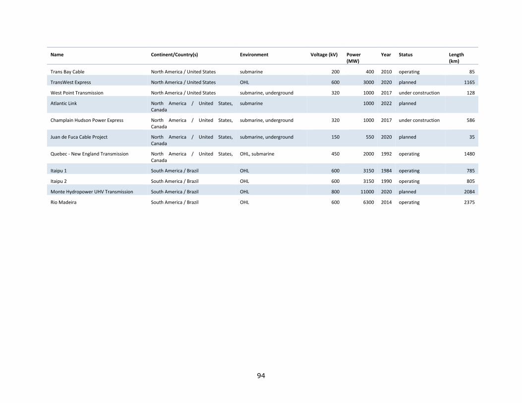
94
Name Continent/Country(s) Environment Voltage (kV) Power (MW)
Year Status Length (km)
Trans Bay Cable North America / United States submarine 200 400 2010 operating 85
TransWest Express North America / United States OHL 600 3000 2020 planned 1165
West Point Transmission North America / United States submarine, underground 320 1000 2017 under construction 128
Atlantic Link North America / United States, Canada
submarine 1000 2022 planned
Champlain Hudson Power Express North America / United States, Canada
submarine, underground 320 1000 2017 under construction 586
Juan de Fuca Cable Project North America / United States, Canada
submarine, underground 150 550 2020 planned 35
Quebec - New England Transmission North America / United States, Canada
OHL, submarine 450 2000 1992 operating 1480
Itaipu 1 South America / Brazil OHL 600 3150 1984 operating 785
Itaipu 2 South America / Brazil OHL 600 3150 1990 operating 805
Monte Hydropower UHV Transmission South America / Brazil OHL 800 11000 2020 planned 2084
Rio Madeira South America / Brazil OHL 600 6300 2014 operating 2375
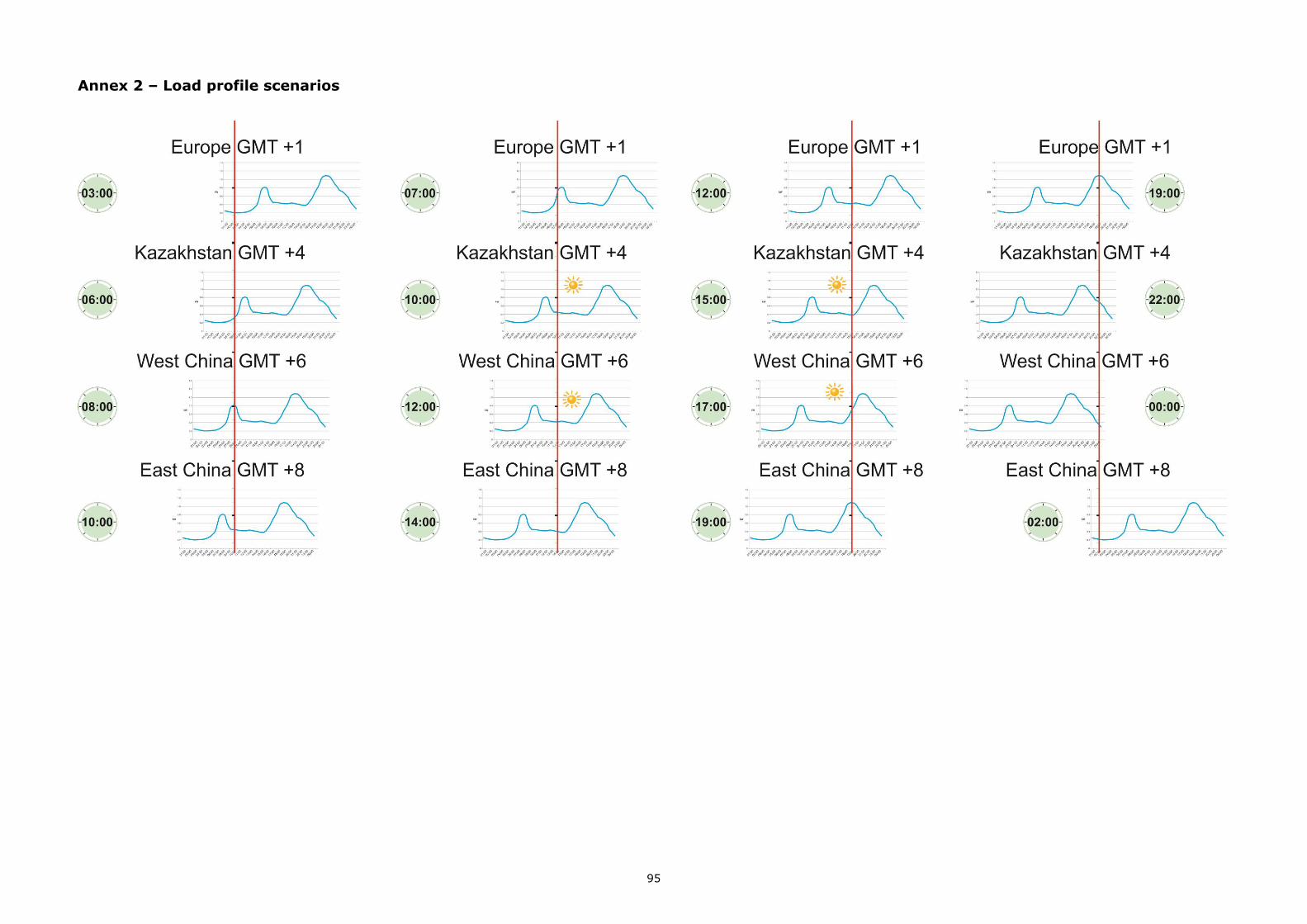
95
Annex 2 – Load profile scenarios
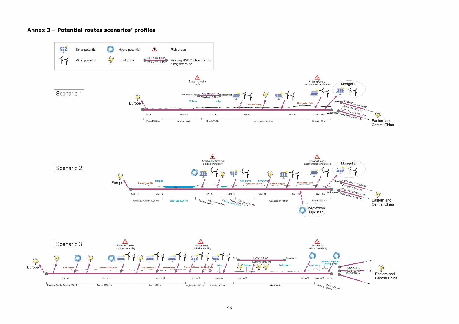
96
Annex 3 – Potential routes scenarios’ profiles
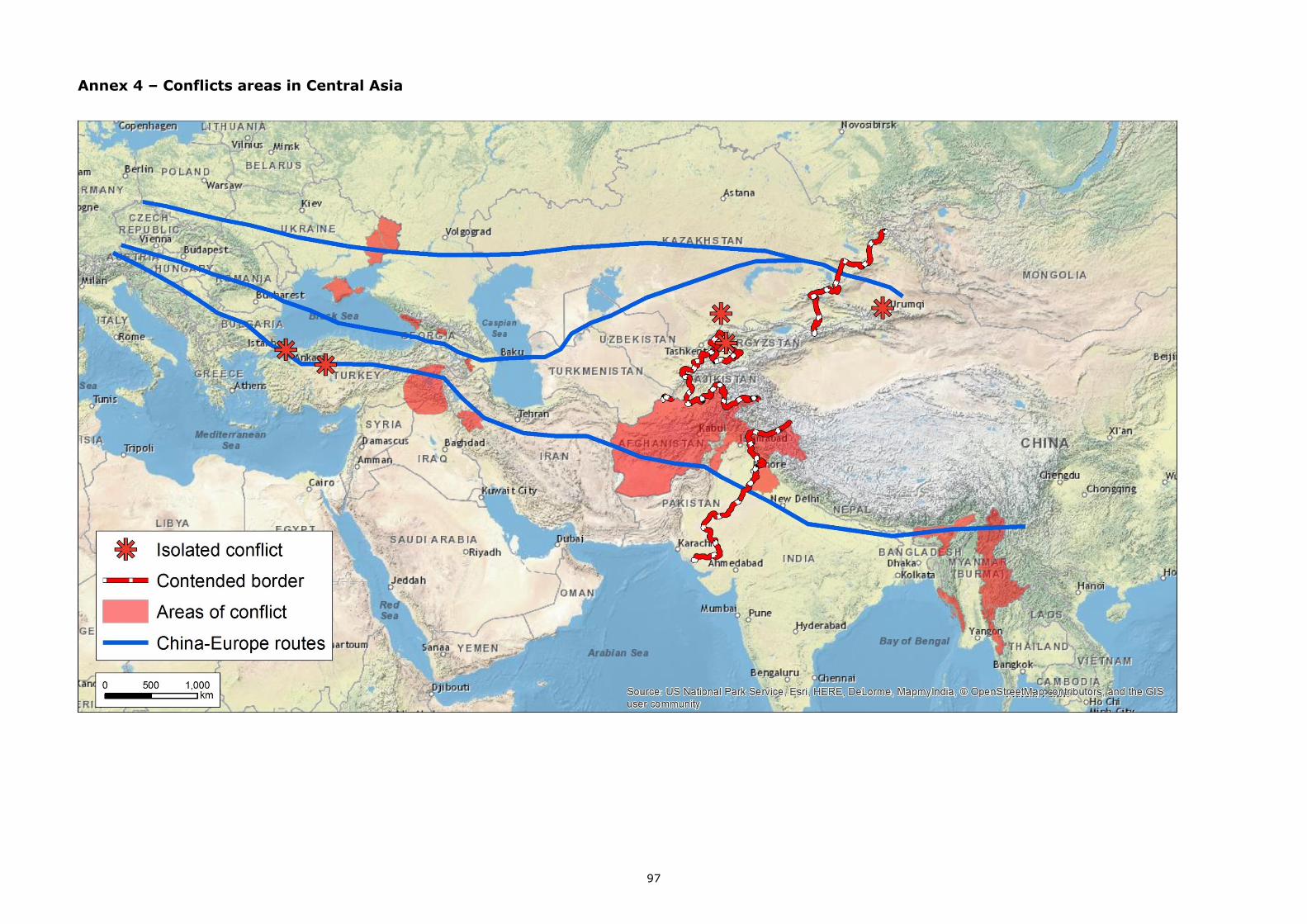
97
Annex 4 – Conflicts areas in Central Asia
98
List of figures
Fig. 1 – China’s Belt and Road Initiative 2
Fig. 2 – Map of HVDC projects distribution 5
Fig. 3 – The concept scheme of NEAG power interconnection network 6
Fig. 4 – Different DC configurations 8
Fig. 5 – Structure and symbol of a thyristor 9
Fig. 6 – Multi-terminal DC systems in a) series, b) in parallel radial and c) in parallel mesh 12
Fig. 7 – Comparative size of AC and DC ROW 14
Fig. 8 – Cost variation vs distance for AC and DC systems 15
Fig. 9 – Cost of converter and line in relation to voltage 18
Fig 10 – Power grid of Azerbaijan 22
Fig. 11 – Nuclear plants in China 24
Fig. 12 – Coal reserves in China 25
Fig. 13 – Hydropower reserves in China 25
Fig. 14 – The power grid of China 26
Fig. 15 – Power grid of Georgia 29
Fig. 16 – Power grid of India 32
Fig. 17 – Power grid of Iran 34
Fig. 18 – The power grid of Kazakhstan 37
Fig. 19 – The power grid of ex-Soviet countries in Central Asia 39
Fig. 20 – The power grid of Mongolia 41
Fig. 21 – Power grid of Myanmar 44
Fig. 22 – Power grid of Pakistan 46
Fig. 23 – Black Sea physiography 52
Fig. 24 – Caspian Sea physiography 54
Fig. 25 – Time zones on Euro-Asiatic continental block 56
Fig. 26 – Typical household load profile 57
Fig. 27 – Wind power potential (W/m2) at 70 m height in China 59
Fig. 28 – Wind power potential in Mongolia 60
Fig. 29 – Wind power potential in India 62
99
Fig. 30 – Wind potential in Afghanistan 63
Fig. 31 – Wind potential in Pakistan 64
Fig. 32 – Wind potential in Iran 65
Fig. 33 – Solar potential in China 66
Fig. 34 – Solar power potential in Kazakhstan 67
Fig. 35 – Solar power potential in Uzbekistan 67
Fig. 36 – Solar power potential in Turkmenistan 68
Fig. 37 – Solar power potential in Tajikistan 69
Fig. 38 – Solar power potential in Kirgizstan 70
Fig. 39 – Solar potential in Myanmar 71
Fig. 40 – Solar potential in India 72
Fig. 41 – Solar radiation map of Pakistan 72
Fig. 42 – Solar potential in Iran 73
Fig. 43 – Solar potential in Georgia 74
Fig. 44 – Main rivers in Xingjian Province and their hydropower potential 74
Fig. 45 – River hydropower potential in Xingjian 75
Fig. 46 – Xingjian wind zones location 75
Fig. 47 – Annual insolation in Xingjian 76
Fig. 48 – Scenarios for an HVDC power interconnection between China and Europe 76
Fig. 49 – The conflict areas in Central Asia 81

GETTING IN TOUCH WITH THE EU
In person
All over the European Union there are hundreds of Europe Direct information centres. You can find the address of the centre nearest you at: http://europea.eu/contact
On the phone or by email
Europe Direct is a service that answers your questions about the European Union. You can contact this service:
- by freephone: 00 800 6 7 8 9 10 11 (certain operators may charge for these calls),
- at the following standard number: +32 22999696, or
- by electronic mail via: http://europa.eu/contact
FINDING INFORMATION ABOUT THE EU
Online
Information about the European Union in all the official languages of the EU is available on the Europa website at: http://europa.eu
EU publications You can download or order free and priced EU publications from EU Bookshop at:
http://bookshop.europa.eu. Multiple copies of free publications may be obtained by contacting Europe
Direct or your local information centre (see http://europa.eu/contact).
KJ-N
A-2
9098-E
N-N
doi:10.2760/67516
ISBN 978-92-79-79358-5