Embed Size (px)
Citation preview

A classification of the lands at wilson’spromontory - Second Edition
July 1999
CENTRE FOR LAND PROTECTIONRESEARCH
Technical Report No. 43
G.T. Sibley & D.B. Rees

ISBN 0 7306 6778 2
ISSN 1038-216X
Sibley, G. T.
A classification of the lands at Wilson’s Promontory
2nd ed.
Bibliography.
Includes index.
ISBN 0 7306 6778 2.
1. Land use –Victoria – Wilson’s Promontory – Classification. Ι. Centre for Land ProtectionResearch. ΙΙ . Title. (Series: Technical report (Centre for Land Protection Research (Vic));no. 43).
333.73099456
Copyright Department of Natural Resources & Environment 1999
This publication may be of assistance to you but the State of Victoria and its employees do notguarantee that the publication is without flaw of any kind or is wholly appropriate for your particularpurposes and therefore disclaims all liability for any error, loss or other consequence which mayarise from you relying on any information in this publication.

PREFACEThis report is a new edition of study by Sibley (1966) of the land types of Wilson’sPromontory. There are a number of reasons why a new edition was deemed warranted.
Firstly, there is little obviously available information on the land types of Wilson’sPromontory that cover the whole geographic area. The original report by Sibley fulfils thisneed, but there are very few copies of the original report, thereby reducing the likelihoodof knowledge and usage of the original report. Therefore a revised, more readily availableedition was necessary.
Secondly, there is the question of scale and intensity of information. This report onWilson’s Promontory is important for land use managers as it provides the basic spatialmapping units for the Statewide Land System (Rowan, 1990) coverage (scale 1:250 000),even though it was regarded by Sibley (1966) as a reconnaissance survey and aframework for further study.
Thirdly, there is the question of the age of the information and the form that it is in, suchas the classification systems used for soil and vegetation types. This has been addressedby updating the classification systems and assessments used for soil and vegetationidentification. There has been no further field data gathered specifically for this report.
Fourthly, there is the question of presentation which is relevant to the potential use of theinformation, including editing. The electronically stored new edition presents the originalin an updated edited format including new diagrams.
This edition has been edited, courtesy of Leisa Macartney, Angela Smith and Grant Boyleof the Centre for Land Protection Research. The diagrams have been redrawn by GrantBoyle, although the main map may need some ground truthing due to the lack of suitablereference points and the reconnaissance nature of the original study. The vegetationclassification has been updated with notes on current and likely changes (Grant Boyle,David Rees), and the soil classification system has also been updated by David Rees(see Appendix 1).
It is hoped that this edition will provide a useful, current overview of land types on Wilson’sPromontory and facilitate an understanding of any future information requirements of landtypes and their behaviour.

TABLE OF CONTENTSPREFACE ....................................................................................................................................... 3
INTRODUCTION .......................................................................................................................... 3
1 REGION NO. 1 - LAND ASSOCIATED WITH GRANITE .............................................. 3
1.1 PROMONTORY LAND-ZONE ............................................................................................... 61.1.1 Land-System 1 .......................................................................................................... 61.1.2 Land-System 2 .......................................................................................................... 7
1.2 SEALER’S COVE LAND-ZONE............................................................................................. 71.2.1 Land-System 3 .......................................................................................................... 7
2 REGION NO. 2 - LAND ASSOCIATED WITH DEEP DEPOSITS OF SAND........................................ 72.1 YANAKIE SOUTH LAND-ZONE ........................................................................................... 9
2.1.1 Land-System 4 .......................................................................................................... 9Land-Unit 4a ........................................................................................................................................ 9Land-Unit 4b ...................................................................................................................................... 11Land-Unit 4c ...................................................................................................................................... 13
2.1.2 Land-System 5 ........................................................................................................ 15Land-Unit 5a ...................................................................................................................................... 15Land-Unit 5b ...................................................................................................................................... 19Land-Unit 5c ...................................................................................................................................... 21Land-Unit 5d ...................................................................................................................................... 23Land-Unit 5e ...................................................................................................................................... 25
2.2 LEONARD BAY LAND-ZONE ............................................................................................ 262.2.1 Land-System 6 ........................................................................................................ 28
Land-Unit 6a ...................................................................................................................................... 28Land-Unit 6b ...................................................................................................................................... 30
2.2.2 Land-System 7 ........................................................................................................ 32Land-Unit 7a ...................................................................................................................................... 32Land-Unit 7b ...................................................................................................................................... 34
2.2.3 Land-System 8 ........................................................................................................ 36Land-Unit 8a ...................................................................................................................................... 36Land-Unit 8b ...................................................................................................................................... 38Land-Unit 8c ...................................................................................................................................... 40
2.3 CHINAMAN’S CREEK LAND-ZONE ................................................................................... 422.3.1 Land-System 9 ........................................................................................................ 42
3 DESCRIPTION OF THE SOIL GROUPS RECOGNISED ............................................. 43
3.1 SOILS OF THE DEEP SAND DEPOSITS ................................................................................ 433.1.1 Soils associated with alkaline sand ......................................................................... 43
(i) Regosol...................................................................................................................................... 43(ii) Terra rossa and rendzina ....................................................................................................... 43(iii) Iron leptopodzol.................................................................................................................... 44
3.1.2 Soils associated with acidic sand ............................................................................ 45(i) Nomopodzol .............................................................................................................................. 45(ii) Regosol ................................................................................................................................. 45(iii) Soils high in organic matter .................................................................................................. 46
3.2 SOILS FORMED ON GRANITE ............................................................................................ 46(i) Podzolised duplex soil.............................................................................................................. 46(ii) Acid brown earth................................................................................................................... 47
REFERENCES ............................................................................................................................. 50
LIST OF FIGURESFIGURE 2 LAND-UNIT 4A (LAND-SYSTEM 4)........................................................................... 10FIGURE 3 LAND-UNIT 4B (LAND-SYSTEM 4) ........................................................................... 12

FIGURE 4 LAND-UNIT 4C (LAND-SYSTEM 4) ...........................................................................14FIGURE 5A LAND-UNIT 5A (LAND-SYSTEM 5) SHOWING NORTH TO SOUTH CROSS SECTION...17FIGURE 5B LAND-UNIT 5A (LAND-SYSTEM 5) SHOWING WEST TO EAST CROSS SECTION........18FIGURE 6 LAND-UNIT 5B (LAND-SYSTEM 5) ...........................................................................20FIGURE 7 LAND UNIT 5C (LAND-SYSTEM 5) ...........................................................................22FIGURE 8 LAND-UNIT 5D (LAND-SYSTEM 5) ...........................................................................24FIGURE 9 LAND-UNIT 5E (LAND-SYSTEM 5)............................................................................27FIGURE 10 LAND-UNIT 6A (LAND-SYSTEM 6) ...........................................................................29FIGURE 11 LAND-UNIT 6B (LAND-SYSTEM 6) ...........................................................................31FIGURE 12 LAND-UNIT 7A (LAND-SYSTEM 7) ...........................................................................33FIGURE 13 LAND-UNIT 7B (LAND-SYSTEM 7) ...........................................................................35FIGURE 14 LAND UNIT 8A OF LAND-SYSTEM 8.........................................................................37FIGURE 15 LAND-UNIT 8B (LAND-SYSTEM 8) ...........................................................................39FIGURE 16 LAND-UNIT 8C (LAND-SYSTEM 8) ...........................................................................41
LIST OF TABLESTABLE 1 LAND-UNITS OF WILSON’S PROMONTORY .................................................................4
APPENDIXAPPENDIX 1.............................................................................................................................48APPENDIX 2..............................................................................................................................49

A CLASSIFICATION OF THE LAND AT WILSON’S PROMONTORY
Original publication 1966. Second edition published 1999.
G.T. SIBLEY & D.B. REES
Centre for Land Protection Research, Department of Natural Resources &Environment, Cnr Midland Highway & Taylor St., Epsom. Vic. 3550.
INTRODUCTIONWilson’s Promontory has been divided into the following units of land classification at five levelsof details:
Regions (2)
Land-Zones (5)
Land-Systems (9)
Land-Units (15)
Land-Components (20)
The criteria used to recognise and map these various units of classification are certain featuresof the environment, namely land-forms, parent material, soil and native vegetation.
The land-systems are indicated on the accompanying map by colours and numbers, while theland-units are indicated by letters. Figures 2 to 16 illustrate and summarise the land-units. Theareas occupied by the regions and land-zones can be recognised by groupings of colours, thatis, by groupings of land-systems. The relationships of the regions, land-zones, land-systemsand land-units to each other are shown in Table 1. A more detailed survey of the Promontorycould well have revealed a greater number of land classification units, particularly land-units andland-components.
1 REGION NO. 1 - LAND ASSOCIATED WITH GRANITEThe initial division of Wilson’s Promontory is into two regions, namely, areas associated withDevonian granite, and areas associated with deposits of Quaternary (Pleistocene and Holocene)sand. This follows the less detailed geological maps available.
}}
least detailed
most detailed

Table 1 Land-Units of Wilson’s Promontory
* refer to Figure 1
1
2
3
4
5
6
7
8
9
REGION
1. Land associated with granite
2. Land associated with deep deposits of sand
LAND-ZONE
PROMONTORY(Areas of granite)
SEALER'S COVE(Areas of granite hillwash)
YANAKIE SOUTH(Areas of dunes associated
with alkaline sand and neutralto slightly acidic sand)
LEONARD BAY(Areas of sand dunes andsand sheets composed of'white' very acidic sand)
CHINAMAN'S CREEK(Low-lying sand sheets withrestricted drainage and soils
high in organic matter)
LAND-SYSTEM
Mountains and hills witheucalypt forests andscrubs
Hills with mostly treelessheaths
Flat sheltered areas withwet forests
Dunes of loose 'paleyellow' alkaline sand
Dunes of dune limestoneand dunes of 'red' neutraltoslightly acidic sand
Sanddunes
Flat sand sheets
Sloping sandsheets(overlaying granite)
Wet heaths and swamps
LAND-UNIT
4a, 4b, 4c
5a, 5b, 5c, 5d, 5e
6a, 6b
7a, 7b
8a, 8b, 8c

Kilometres
N
0 3 6Centre for Land Protection ResearchMap produced 16/7/99 by:
Ph: (03) 54 304444
#
#
#
#
#
#
#
#
#
#
#
# #
#
#
#
#
#
#
#
#
##
#
#
#
#
#
#
#
#
#
# #
# #
#
#
#
1
9
4
2
1
9
9
8b
3
3
9
9
6a8c
4a
4c/6
98b
1
4b
2
9
7a
5a
9
8a
2
8a
8b
9
9
7b
4c/65d
1
4a
5e
2
8c
2
9
2
7b
5c
6b
4b
5b
1
3
4a
8b
7b
8a
8a
4a
8
8a
3
98a
7
9
7b
4c/6
8a
8b
7
9
8a
8a1 9
4c/6
9
4c
8a
9
7b
2
1
9
4a
5b
7
8
4c
9
4c/6
8b
9
3
5a
8a
4b
4b
7
5c
1
8
7
7b
4b
7b
7b
4c/6
4c/68a
6b
8b
4c/6
9
1
4c
2
8b
7b
8b
9
9
8b
7b
4a
8b
4a
9
4a
9
4c
4c/6
8b
4c
7
7
4b
7
5c
7b
SUGARLOAF
BULL PASS
DARBY BAY
WHISKY BAY
NORMAN BAY
OBERON BAY
SOUTH PEAK
SAND ISLAND
MOUNT HUNTER
BARRYS HILL
BIG HUMMOCK
MIRANDA BAY
BISHOP PEAK
MOUNT RAMSAY
TIDAL RIVER LEONARD BAY
MOUNT OBERON
KERSOP PEAKMOUNT W ILSON
SILVER SW AMP
MOUNT VEREKER
MOUNT LEONARD
WATERLOO BAY
MOUNT BOULDERMOUNT NORGATE
MARTINS HILL
SHALLOW BIGHT
TIN MINE HILL
MOUNT MARGARET
CHINAMAN KNOB
BANYALLA PEAK
LOOKOUT ROCKS
THE CATHEDRALMOUNT LA TROBE
LITTLE OBERON
THOMPSONS BAY
BOULDER RANGE
SEA EAGLE BAY
MOUNT SINGAPORE
MOUNT ROUNDBACK
FIVE MILE PEAK
LA TROBE RANGE
MOUNT McALISTER
YANAKIE ISTHMUS
TELEGRAPH SWAMP
VERERER OUTLOOK
FRESHWATER LAKE
CAPE WELLINGTON
LITTLE SUGARLOAF
LITTLE OBERON BAY
BOAT HARBOUR HILL
NORTH WATERLOO BAY
LITTLE WATERLOO BAY
Figure 1 Land-Unit map of Wilsons Promontory
The areas associated with granite (Region 1) are divided into two land-zones (see Table 1).Promontory Land-Zone comprises the hills and mountains of granite, and it in turn is Thesubdivided into Land-Systems 1 and 2. Sealer’s Cove Land-Zone comprises flat areas built upof sandy and clayey deposits of granitic hillwash and constitutes Land-System 3.
Little time was spent in studying the land in Region 1, therefore the three land-systems have notbeen examined in sufficient detail to allow for the recognition of land-units and land-components.More field work is required to record the land-forms, soils and native vegetation. However, fromthe work done thus far, it seems likely that the granite areas, particularly the hills and mountainsof Land-System 1, are not so readily subdividable in the same way as the areas of Quaternarysand in Region 2, which have been subdivided into 15 land-units. It could be that it isimpracticable to recognise land-units within the three land-systems of Region 1.
1.1 Promontory Land-Zone
1.1.1 Land-System 1
This land-system is by far the largest of all the land-systems in the survey area. It occupiesmost of the granite hills and mountains, and includes those hills and mountains that are covered,in the main, with eucalypt forest and scrub communities.
Any future division of the land-system into land-units would probably be on the basis of thenative vegetation. It would be a major study in itself to describe and map the numerous plantcommunities and their habitats. There is a wide range of habitats and communities, their formand composition have been severely altered by recurrent bushfires since European settlement ofGippsland; access into the mountains is almost non-existent. This report has recorded thefloristics and structure of some of the more important communities, and can be designated asland-components:
(i) areas of outcropping rock - these are a noticeable feature of the land-system. Thedominant species are lichens and mosses.
(ii) treeless heaths - these grow in both comparatively dry and comparatively wet habitats.Generally, the heaths in the drier sites have Kunzea ambigua as the dominant species,whereas the heaths in wetter sites are dominated by Melaleuca squarrosa, Leptospermumcontinentale, and a pink-flowered species that may be Pink Beard-Heath. Both heathcommunities in the land-system are not widespread but rather are minor components.
(iii) scrubs - stunted eucalypt communities, generally less than about three metres in height.Eucalyptus baxteri is the dominant species, and one of the peppermints probably E. willisiiis often present also. There is a well-developed heath ground flora, which includesAllocasuarina paludosa, Xanthorrhoea australis, Leptospermum myrsinoides, Banksiamarginata and Hakea sericea as important species.
(iv) dry sclerophyll forests - there is a number of associations represented in the dry sclerophyllforest communities, the most common of which are those that include E. baxteri, E. obliqua,and a peppermint (E. dives or E. radiata). The dry sclerophyll forests are probably the mostwidespread of the sub-formations in the land-system. They have been severely damagedby bushfires during the past 100 years, and, in some areas, their re-establishment has beenvery slow and they appear to be more like scrub communities. A study of the ecology of thescrubs and dry sclerophyll forests is made more difficult by the bushfire influence.
(v) wet sclerophyll forests - common eucalypts in this sub-formation are E. obliqua and E.cypellocarpa. A blue gum (E. globulus) also occurs in a number of areas. E. regnans ispresent also in a few sheltered sites. Some of the common understorey species arePomaderris apetala, Bedfordia arborescens and tree-ferns.

(vi) rainforest - patches of what might be termed cool temperate rainforest occurs in sheltered,moist gullies between the hills. Lilly pilly is a prominent tree species, and clematis andother lianas help to characterise the vegetation.
The soils in the land systems generally can be placed into the podzolised duplex soils and acidbrown earths, which are described in Section 2.
1.1.2 Land-System 2
This is the second, and by far smaller, of the two land-systems on granite. It is found in thenorthern and north-eastern parts of the National Park, and is recognised by its extensive areasof treeless heath, although there are small patches of forest and scrub scattered throughout.
The heath communities are both short (1 m) and stunted (less than 1 m). Mostly, the followingspecies are numbered among the dominant members of the communities: A. pusilla, A.paludosa, Hakea sericea, H. ulicina, a third Hakea species unidentified for this report, B.marginata, Isopogon ceratophyllus, L. continentale. In addition to these communities, which arein comparatively dry sites, there are other heath communities in wetter sites where seepagelines raise the moisture status of the soil. The dominant species differ, with species such asPink Beard-Heath and Flat Cord-Rush. These wetter areas appear to bear no necessary causalrelationship to topography and lines of drainage due to occurrences of species on steep convexslopes near the tops of hills. There may be a relationship between species and lines of seepageoriginating from fractures and joints in the granite. The patches of scrub in the land-system aremade up of E. obliqua and/or E. baxteri. In addition, woodland stands of B. serrata form anotherminor plant community.
The soil of the heath communities and the eucalypt scrub is a podzolised duplex soil, whereasthe soil of the B. serrata woodlands is a very deep, sandy nomopodzol, which is quite differentfrom the podzolised duplex soil. Both groups of soils are described in Section 2. For reasonsoutlined in Land-System 8, it is thought that the small, scattered deposits of fine sand of theBanksia woodlands are of wind-blown origin and bear no direct relationship to the granite hills.Where these deposits are extensive they have been separated and mapped as part of Land-System 8, but those that are too restricted for this are included within Land-System 2 as land-components.
1.2 Sealer’s Cove Land-Zone
1.2.1 Land-System 3
The separation of Land-System 3 was made by aerial photo-interpretation, however there hasbeen no field work to check it. Therefore, no precise information on soils and vegetation can begiven, so the land-systems should be regarded as provisional until such time as a ground surveyis conducted. The interpretation of the model viewed under the stereoscope is that of flat orgently sloping areas in sheltered sites at the base of the granite mountains, with a dense, moistwet sclerophyll forest or rainforest. Presumably the soils have formed in deep deposits ofgranitic hillwash. The land-system was identified under the stereoscope in five localities,namely, the valley facing Sealer’s Cove, two areas behind Five Mile Beach, a narrow valley tothe east of Darby River and the upper section of Tidal River valley.
2 region No. 2 - land associated with deep deposits of sand
The deep deposits of sand that make up Region 2 are given a Quaternary age (Pleistocene andHolocene) by geologists. The region is divided into three land-zones, as indicated in Table 1.
Yanakie South Land-Zone includes areas of dunes composed of ‘pale yellow’ alkaline sand,‘red’ slightly acidic to neutral sand, and a soft rock called dune limestone (or aeolianite), which isvery similar in composition to the alkaline sand. These three materials are related to each otherin composition and formation, and have been used as the basis for subdividing Yanakie SouthLand-Zone into Land-Systems 4 and 5. In turn, these two land-systems are divided into land-units. The land-units within each land-system share the same parent materials, land-forms,soils and native plant species, all of which characterise that land-system, but the land-units are ameans of highlighting important variations within the land-system in the arrangement or patternof those environmental features.
Leonard Bay Land-Zone takes in the deep deposits of white, very acidic sand sheets and havebeen used to subdivide the land-zone into Land-Systems 6, 7 and 8. Each of these have beendivided into land-units on the same basis as that used for the land-systems in Yanakie SouthLand-Zone.
Chinaman’s Creek Land-Zone includes flat, low-lying sand sheets with restricted drainage andsoils high in organic matter. The area occupied by the land-zone is mapped as Land-System 9.

2.1 Yanakie South Land-Zone
2.1.1 Land-System 4
Land-System 4 incorporates dunes composed of loose, ‘pale yellow’ alkaline sand. This sand ismade up of two distinct materials, namely, finely broken calcareous sea-shells and quartzgrains, of which the sea-shells make up 60 to 70 per cent of the total sand grains. Alkalinereposal soils have developed in the sand and their description is given in Section 2. A verycommon plant community in the land-system is a dry scrub dominated by all or some of thefollowing species:
Leptospermum laevigatum, Leucopogon parviflorus, Acacia verticillata, Acacia longifolia andBursaria spinosa.
The land-system occurs behind many of the beaches in the National Park and the mostextensive single area stretches across the Yanakie Isthmus.
Three land-units have been recognised within the land-system, and the features used todistinguish each of them relate to difference in the shape, dimensions and direction oforientation of the dunes. There are also differences of lesser importance in the vegetativecover.
Land-Unit 4a
A summarised description of the land-unit is given in Figure 2. The land-unit comprises thelarge, massive sand dunes mainly found along the western beach of the Yanakie Isthmus, andalso facing Oberon Bay and Corner Inlet. The dunes are orientated at right angles to the beach,and most have no plant cover and so are subject to movement by the wind. They are close toone another, that is, the inter-dune corridors (or swales) are very narrow and, in places, almostnon-existent. Compared with the dunes in Land-Unit 4b, these dunes have a wider cross-section in relation to their height so that their sides are not as steep and tend to be convex inoutline. Their height is estimated to be generally within the range of 9-25 metres, although thehighest appear to be over 30 metres. A few of the dunes have a core of dune limestone, but theoverall frequency of this is unknown.
In a few places, the land-unit takes in parts of granite hills along the coast because of thepresence of dunes on the sides of the hills. Evidently the on-shore winds have been strongenough to lift the sand up the sides of the hills where it has been stabilised by scrub vegetation.An example of this is to be seen above the sand bar that lies across the mouth of the DarbyRiver. Also at this site, the sand of the dunes is underlain by dune limestone showing that thedunes have been held in position on the side of the hill for a sufficient length of time to allow thedune limestone to form.

Landform Large massive sand dunes at right angles to the beach.
Geology Wind-blown calcareous sand of predominantly broken sea shells; with quartz grains.
Soil Alkaline regosol
Native
Vegetation
Most of the land-unit has no plant cover and is damaged by wind erosion. Facing the beach, marram grass and a low scrub ofLeptospermum laevigatum are dominant. Inland, the vegetation changes to a taller dry scrub of Leptospermum laevigatum,Leucopogon parviflorus, Allocasuarina stricta, Acacia sophorae and Bursaria spinosa.
Figure 2 Land-Unit 4a (Land-System 4)
NorthSouth

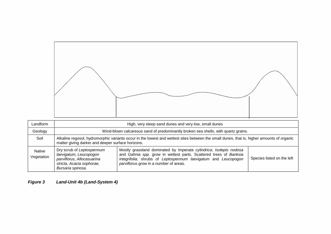
Land-Unit 4b
A summarised description of the land-unit is given in Figure 3. Land-Unit 4b consists of massivesand dunes of unusual shape separated in many parts by wide inter-dune corridors upon whichlie very small dunes. In some parts of the land-unit, the massive dunes are closely spacedmaking the interdune corridors rather narrow. The unusual shape of the massive dunes iscaused by their very long main axes which turn back sharply to form long, sinuous andseemingly jumbled land-forms. The overall direction of orientation of these dunes is at rightangles to the beach. Their height corresponds to the estimates given for the dunes in Land-Unit4a, but their width is smaller in relation to height, making their sides steeper. Some of the duneshave a core of dune limestone, but the overall frequency of this is unknown.
The land-unit is found on the inland (leeward) side of Land-Unit 4a, and its massive dunes arecovered and stabilised by a dry scrub vegetation of the species listed in Figure 3 and are thesame as those growing in Land-Unit 4a. The interdune corridors and small dunes generallysupport and are stabilised by a grassland community (see species list, Figure 3), althoughscattered trees and shrubs do grow in some localities.
The map shows Land-Unit 4b to be largely on the Yanakie Isthmus between the northernboundary of the proposed extension to the National Park and Darby River (Figure 1). There isalso a smaller area in the valley behind Oberon Bay
Landform High, very steep sand dunes and very low, small dunes
Geology Wind-blown calcareous sand of predominantly broken sea shells, with quartz grains.
Soil Alkaline regosol, hydromorphic variants occur in the lowest and wettest sites between the small dunes, that is, higher amounts of organicmatter giving darker and deeper surface horizons.
NativeVegetation
Dry scrub of Leptospermumlaevigatum, Leucopogonparviflorus, Allocasuarinastricta, Acacia sophorae,Bursaria spinosa.
Mostly grassland dominated by Imperata cylindrica; Isolepis nodosaand Gahnia spp. grow in wettest parts. Scattered trees of Banksiaintegrifolia; shrubs of Leptospermum laevigatum and Leucopogonparviflorus grow in a number of areas.
Species listed on the left
Figure 3 Land-Unit 4b (Land-System 4)
Land-Unit 4c
A summarised description of the land-unit is given in Figure 4. Land-Unit 4c is readilydistinguished from the two previous land-units by the size of its dunes and their directionof orientation. They are parallel to the beach and much smaller in size (no more thanabout six metres in height). The soils and plant communities are similar to those in Land-Units 4a and 4b.
The only area of the land-unit positively identified is at the Tidal River camping ground.There are a number of other areas along the east coast beaches, and facing Corner Inlet,that are marked on the map as 4c or 6 because, although the dunes in these areas areparallel to the beaches, no study has been made of the sand to find out whether it iscomposed of mainly broken sea-shells, and therefore alkaline, or solely of quartz grainsand therefore acidic. If the former, the areas come within Land-Unit 4c, but if the latter,they should be placed in Land-System 6 and an additional Land-Unit designated as 6c.
In a number of areas of 4c or 6 there are long, narrow, wet heaths and swamps in thecorridors between the parallel rows of dunes. The largest of these wet areas is indicatedon the map as Land-System 9 but most are too small to separate out from Land-Unit 4c or6.

Landform Sand dunes parallel to the beach
Geology Wind-blown sand of predominantly broken sea shells; with quartz grains.
Soil Alkaline regosol
NativeVegetation
Dry scrub of Leptospermum laevigatum, Leucopogon parviflorus and Allocasuarina stricta. In some areas, the front dune has marramgrass on the seaward side.
Figure 4 Land-Unit 4c (Land-System 4)
beachbeach

2.1.2 Land-System 5
Land-System 5 incorporates both the dunes formed of dune limestone and those formedof loose, ‘red’, neutral to slightly acidic sand. It is believed that the latter dunes areassociated through their genesis with those formed of dune limestone in that the red sandwas stripped and winnowed off the limestone dunes by wind. The two kinds of dunes arein close proximity to each other and intermingle to some extent. They occupy aconsolidated area forming the land-system between Cotter Lake in the north and DarbyRiver in the south.
The limestone dunes are larger than the dunes of red sand, with some reaching giganticdimensions such as the two forming Red Hill between the aerodrome site and DarbyRiver. They often have the smaller red dunes lying on them towards their eastern andsouthern slopes. Elsewhere, the red dunes are usually found to the leeward (north-east tosouth-east) side of the limestone dunes, which are assumed to be their points of origin.
The material composing the dune limestone is almost identical to that forming the paleyellow calcareous sand of the sand dunes in Land-System 4. That is, about 80 per cent ofthe sand grains is finely broken sea-shells, with the remainder as quartz grains. Thefreshly exposed limestone is soft and coarsely laminated, but its surface hardensconsiderably on prolonged exposure. Those dunes are considered to be older than thedunes in Land-System 4 due to the length of time elapsed during which the change fromloose sand to soft rock took place.
Soils of four groups occur on and in the two types of dunes. Terra rossas and rendzinasare on the limestone dunes. Red iron leptopodzols and light yellowish brown alkalinesands constitute the red dunes. All these soils are described in Section 3. The alkalinesands occur as a core in many of the red dunes and their properties are almost identicalto the properties of the alkaline sands in Land-System 4 and to the material composingthe dune limestone. The red iron leptopodzols overlie the alkaline sands to a depth of 38 - 90 centimetres.
Three dominant plant communities are widespread throughout the land-system and theyshow consistent relationships with the soil groups. The first community is a tall dry scrubdominated by shrubs and small trees or L. laevigatum, Leucopogon parviflorus,B. ntegrifolia, Allocasuarina verticillata and A. longifolia, and is associated with the terrarossas and rendzinas on the dunes of dune limestone. The second community is awoodland of B. integrefolia with ground flora dominated by bracken; this is associatedwith the communities of L. laevigatum, Leucopogon parviflorus and Bursaria spinosa insome localities. The third plant community is a grassland composed mainly of nativegrasses, bracken and the sedge Isolepis nodosa. In some areas the dominant speciesare Imperata cylindrica (Bladey Grass) and Isolepis nodosa, and elsewhere bracken is co-dominant with a number of grasses and Isolepis nodosa. The grasslands are alsoassociated with the red iron leptopodzols.
Land-system 5 is divided into five land-units to separate a number of different patternsformed by varying arrangements of the dune land-forms, soil groups and native plantcommunities.
Land-Unit 5a
This land-unit takes in the prominence known as Red Hill, which lies between theaerodrome to the north and Darby River to the south. Red Hill consists of two parallelgigantic limestone dunes separated by a ‘valley’ or corridor. Features are summarised inFigures 5a & 5b.

The ridges of the two dunes have both rendzinas and terra rossas. There are goodexamples of terra rossas along the north-facing slope of the northerly dune. Red ironleptopodzols are the most widespread soil group, and lie on the south-facing slope of thenortherly dune and over the southerly dune, except along the ridge and western slope. Insome parts, the deposits in which the leptopodzols have formed occur as small dunes.
The major plant communities are indicated in Figure 5a & 5b. There are also thickets ofL. laevigatum regrowth in places along the ridges, which appear to be confined to the terrarossa soils.

Landform Two very long and gigantic parallel dunes, 3 - 5 kilometres in length and 30 - 40 metres in height.
Geology Dune limestone and wind-blown sand.
Soil Terra rossa and rendzina Red iron leptopodzol overlying a light yellowish browncalcareous sand
Terra rossa andrendzina
NativeVegetation
Dry scrub of Lepto. laevigatum, Leuco.parviflorus, Acacia sophorae,Allocasuarina stricta, Banksiaintegrifolia
Woodlands of B. integrifolia with a ground floradominated by bracken. Also grassland dominated byImperata cylindrica and Isolepis nodosa.
Dry scrub as on left
Figure 5A Land-Unit 5a (Land-System 5) showing north to south cross section.
NorthSouth
dune limestone

Soil Terra rossa and rendzina Red iron leptopodzol overlying a light yellowish brown calcareous sand
NativeVegetation
Dry scrub of species listedabove
Vegetation as in Figure 5A.
Figure 5B Land-Unit 5a (Land-System 5) showing west to east cross section.
West East

Land-Unit 5b
Land-Unit 5b lies to the immediate south of Cotter Lake, and is made up of a series of fourparallel dunes of dune limestone. These dunes are very big although not as big as those inLand-Unit 5a. The approximate dimensions of the dunes are given in Figure 6, together with asummary of the inter-relationships of their environmental features.
The rendzinas are usually deep (up to 1.5 metres) on the sides of the dunes and in the corridors,but on the ridges they are hollow with broken limestone in the soil. There are a few outcrops oflimestone in the corridors and here, too, the soil is shallow. Red iron leptopodzols were found ina few sites, for examples, at the bases of the dunes and in small drainage lines running downthe sides of the dunes.
The dominant plant communities are indicated in Figure 6. Imperata cylindrica and bracken aregenerally absent from the grasslands of the corridors and this is probably related to the presenceof the rendzinas. The few small areas of bracken that do occur are indicative of the scattereddeposits of red iron leptopodzols.

Landform A series of parallel dunes, 15 m to 30 m in height and 400 m to 1000 m in length.
Geology Dune limestone and wind-blown sand.
Soil Mostly rendzina, although there are restricted areas of red iron leptopodzol and terra rossa
NativeVegetation
Dry scrub of Leptospermum laevigatum,Leucopogon parviflorus, Banksia integrifolia,Acacia sophorae, Allocasuarina astricta.
Grassland of native grasses,Isolepis nodosa.
Dry scrub of species listed on left.
Figure 6 Land-Unit 5b (Land-System 5)
North
dune limestone
South

Land-Unit 5c
Land-Unit 5c consists largely of small to medium-sized dunes which are characterised bydeep red iron leptopodzols supporting woodlands of Banksia integrifolia (see Figure 7).Also characteristic is the bracken-dominant ground flora which is indicative of theleptopodzols.
Some of the larger dunes have cores of dune limestone, and in a few sites there aresurface exposures of limestone with terra rossa soils. The prevalence of the dunelimestone is unknown, however, it is thought that the deposits that do exist are confined tothe larger dunes and are absent from the smaller dunes. The larger dunes are orientatedin an east-west direction, but the small dunes do not have a constant line of orientation

Landform Small and medium-sized dunes, between about 3m and 12 m in height
Geology Dune limestone and wind-blown sand.
Soil Terra rossa Iron leptopodzoloverlying calcareous
sand
Terrarossa
Red iron leptopodzol overlying yellowish brown calcareous sand
NativeVegetation
Dry scrub ofBanksia integrifolia,Lepto. laevigatum,Leuco. parviflorus,Acacia sophorae
Species listed on right Specieson the
left
Generally a woodland of Banksia intergrifolia with a ground flora dominatedby bracken. Also scattered understorey bushes of Leptospernumlaevigatum, Leucopogon parviflorus and Bursaria spinosa
Figure 7 Land Unit 5C (Land-System 5)
North and WestSouth and East
dune limestone wind blown sand
North and WestSouth and East
dune limestone wind blown sand
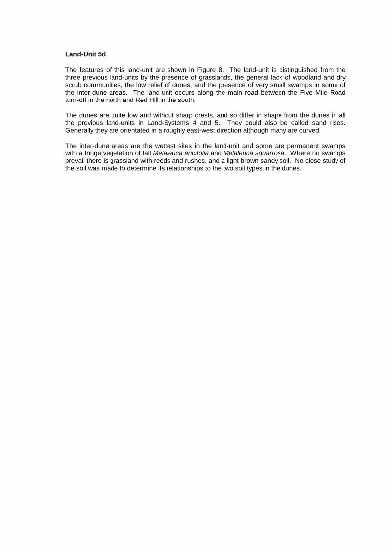
Land-Unit 5d
The features of this land-unit are shown in Figure 8. The land-unit is distinguished from thethree previous land-units by the presence of grasslands, the general lack of woodland and dryscrub communities, the low relief of dunes, and the presence of very small swamps in some ofthe inter-dune areas. The land-unit occurs along the main road between the Five Mile Roadturn-off in the north and Red Hill in the south.
The dunes are quite low and without sharp crests, and so differ in shape from the dunes in allthe previous land-units in Land-Systems 4 and 5. They could also be called sand rises.Generally they are orientated in a roughly east-west direction although many are curved.
The inter-dune areas are the wettest sites in the land-unit and some are permanent swampswith a fringe vegetation of tall Melaleuca ericifolia and Melaleuca squarrosa. Where no swampsprevail there is grassland with reeds and rushes, and a light brown sandy soil. No close study ofthe soil was made to determine its relationships to the two soil types in the dunes.

Landform Low sand dunes, up to 4.5 m in height but mostly less than 3 m.
Geology Wind-blown deposits of quartz sand overlying calcareous sand.
Soil Red iron leptopodzoloverlying a light yellowishbrown calcareous sand
Lightbrownsand
As for far left column As for far left column Lightbrownsand
NativeVegetation
“Grassland” of bracken,native grasses
Rushessedgesgrasses
As for far left column Wet scrub of tallMelaleuca spp.around edge
As for far left column Rushessedgesgrasses
Figure 8 Land-Unit 5d (Land-System 5)
swampdune dune dune
swamp swamp
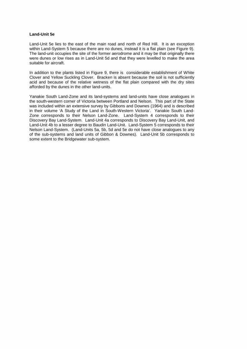
Land-Unit 5e
Land-Unit 5e lies to the east of the main road and north of Red Hill. It is an exceptionwithin Land-System 5 because there are no dunes, instead it is a flat plain (see Figure 9).The land-unit occupies the site of the former aerodrome and it may be that originally therewere dunes or low rises as in Land-Unit 5d and that they were levelled to make the areasuitable for aircraft.
In addition to the plants listed in Figure 9, there is considerable establishment of WhiteClover and Yellow Suckling Clover. Bracken is absent because the soil is not sufficientlyacid and because of the relative wetness of the flat plain compared with the dry sitesafforded by the dunes in the other land-units.
Yanakie South Land-Zone and its land-systems and land-units have close analogues inthe south-western corner of Victoria between Portland and Nelson. This part of the Statewas included within an extensive survey by Gibbons and Downes (1964) and is describedin their volume ‘A Study of the Land in South-Western Victoria’. Yanakie South Land-Zone corresponds to their Nelson Land-Zone. Land-System 4 corresponds to theirDiscovery Bay Land-System. Land-Unit 4a corresponds to Discovery Bay Land-Unit, andLand-Unit 4b to a lesser degree to Baudin Land-Unit. Land-System 5 corresponds to theirNelson Land-System. (Land-Units 5a, 5b, 5d and 5e do not have close analogues to anyof the sub-systems and land units of Gibbon & Downes). Land-Unit 5b corresponds tosome extent to the Bridgewater sub-system.

2.2 Leonard Bay Land-Zone
Leonard Bay Land-Zone takes in the deep deposits of ‘white’, very acidic sand formed intosand dunes and sand sheets. The sand dunes and sand sheets are used to subdivide theland-zone into Land-Systems 6, 7 and 8, each of which is further divided into land-units.

Landform Flat plain.
Geology Deposits of both quartz sand and calcareous sand.
Soil A mixture of red iron leptopodzol and light yellowish brown calcareous sand.
NativeVegetation
A grassland of native grasses and tussocks of Isolepis nodosa. No trees or shrubs.
Figure 9 Land-Unit 5e (Land-System 5)

2.2.1 Land-System 6
Land-System 6 incorporates those areas where the white acidic sands are formed intosand dunes. Both the presence of the dune land-form and the shape and uniformity ofsize of the sand grains indicate a wind-blown origin of the material.
Humus and iron nomopodzols have developed in the sands and these two soil groupsoccur throughout the land-system. There is also a very limited occurrence of what isbelieved to be acidic regosols. These three soil groups are described in Section 2.
There is a widespread and dominant plant community which largely helps to characterisethe land-system. It is a treeless, stunted (less than 0.6 metres in height) heath in which alimited number of species are dominant, such as Allocasuarina pusilla, Leptospermummyrsinoides, L. continentale, B. marginata, Xanthorrhoea australis, Isopogonceratophyllus and Hypolaena fastigiata. This plant community is confined to andindicative of the nomopodzols.
Land-System 6 occurs in two distinct areas: one between the main road and the VerekerRange, and the other along the west coast from Whisky Bay to Norman Bay. There aredifferences in land-form and vegetation between these two areas and they aredistinguished from each other as Land-Units 6a and 6b.
Land-Unit 6a
A summarised description of the land-unit is given in Figure 10. The sand dunes are verylow and without sharp ridges, and could be called sand rises. They are not uniformlyorientated in one direction but rather their long axes tend to vary in direction. There are afew exceptions to this general description and these are very large dunes which areorientated uniformly in an approximate east-west direction.
This land-unit is found between the main road on the west and the Vereker Range on theeast. It differs from Land-Unit 6b in the size and shape of its dunes and in the presencebetween the dunes of clearly defined drainage lines and swamps with their attendant plantcommunities. The two largest swamps have been included in Land-System 10.
The land-unit is adjacent to and on the leeward side of Land-Units 5c and 5d of Land-System 5. In this location it is in an analogous position to that occupied by the FollettLand-System of Gibbons and Downes in respect of its position relative to the Nelson andDiscovery Bay Land-Systems.
In the southern part of the Yanakie Isthmus, the positions of Land-Systems 4, 5 and 6,with respect to each other, represent what is thought to be a sequence of successivelyolder parent materials and soils. The alkaline, pale yellow regosols in Land-System 4 arebelieved to be the youngest soils, the terra rossa and rendzinas in Land-System 5 areolder, while the red iron leptopodzols in Land-System 6 are believed to be the oldest. Thissequence is the same in principle as the one described for the south-western corner ofVictoria by Gibbons and Downes. These authors believe that the sequence is the result ofsuccessive periods of wind-stripping and re-sorting of soils off the limestone dunes,probably at widely different times, and that the resulting sand deposits have beensubjected to varying degrees of podzolisation under different climatic regimes and duringdifferent periods of time.

Landform Mostly low sand dunes or sand rises up to about 4.5 metres in height but mostly less than 3 metres. There are a few large dunes thathave more of an affinity with Land-Unit 6b.
Geology Wind blown deposits of acidic, “white” quartz sand.
Soil Humus and iron nomopodzols
NativeVegetation
Stunted heath of mainly Allocasuarinapusilla, Leptospermum continentale, L.myrsinoides, Banksia marginata,Xanthorrhoea australis, Epacris impressa,Isopogon ceratophyllus. There are a fewscattered stands of B. serrata.
Scrub of shortE. obliqua andE. willisii with tallunderstorey ofMelaleuca spp.,L. continentale,Acacia verticillata
Species listed as per previous sand dune site.
Free water;wet heath atwater edgedominated byMelaleucaspp.
Figure 10 Land-Unit 6a (Land-System 6)
drainage line swamp

Land-Unit 6b
This land-unit is found along the west coast from Whisky Bay to Norman Bay. Asummarised description and diagram is given in Figure 11. Mostly the sand dunes arelarge (many metres in length and up to about 15 metres in height) and many of them liedirectly over granite. The position of the dunes inland, with respect to the beaches andtheir orientation at right angles to the beaches, supports the conclusion that the sand hasbeen blown inland away from the beaches to its recent position. The soil groups occurringin the land-unit are described in Section 2 where the relationships of the humus and ironnomopodzols and acidic regosols to each other are described.
The part of the land-unit adjacent to the Tidal River camping ground is somewhat differentfrom the rest of the land-unit in that (i) there is one long dune sub-parallel to the beachinstead of at right angles, (ii) all the other dunes in the area, which are at right angles tothe beach, are very much smaller than the dunes elsewhere in the land-unit that areassociated with Squeaky Beach, Picnic Point and Whisky Bay, and (iii) the sand dunes donot lie over the granite but are built up on the floor of the Tidal River Valley.

Landform Sand dunes at right angles to the beach, most are large and massive and overlie granite
Geology Wind - blown deposits of acidic “white” quartz sand
Soil Mostly iron nomopodzols, also acidic regosol and humus nomopodzol
NativeVegetation
Facing the beach and for a short distance inland, there is a dry scrub dominated by Leptospermum laevigatum, also with Allocasuarinastricta, Leucopogon parviflorus and Acacia sophorae in some localities. Further inland, there are no shrub species but a stunted (lessthan 60 cm high) heath composed mainley of Casuarina pusilla, Leptospermum myrsinoides, Leptospermum continentale,Xanthorrhoea australis, Banksia marginata, Isopogon ceratophyllus, Epacris impressa, Correa reflexa, Hypolaena fastigiata,Lepidosperma spp.
Figure 11 Land-Unit 6b (Land-System 6)

2.2.2 Land-System 7
Land-System 7 incorporates those areas where the white acidic sands have beendeposited as flat (or nearly flat) sheets without the formation of dunes. Humus and ironnomopodzols have developed in the sands and these two soil groups occur throughoutthe land-system.
The land-system occurs as a number of individual areas lying across the northern part ofthe Promontory. The largest of these differs to some extent from the rest and isdesignated as Land-Unit 7a. The other areas are collectively called Land-Unit 7b.
Land-Unit 7a
This land-unit lies below Vereker Range on the western side. The land surface has a verygentle and gradual upward slope towards Vereker Range in addition to slight localundulations. It is separated from Land-Unit 6a by the presence of sand dunes, and fromLand-Unit 8c by a difference in slope and a lack of entrenched creeks. Environmentalfeatures are summarised in Figure 12.

Landform Flat sand sheet
Geology Deposits of acidic ‘white’ quartz sand
Soil Humus nomopodzols
NativeVegetation
A short (less than one metre in height) heath mainly composed of Allocasuarina pusilla, Xanthorrhoea australis, X. minor, Banksiamarginata, Leptospermum myrsinoides. A few isolated trees of B. serrata.
Figure 12 Land-Unit 7a (Land-System 7)

Land-Unit 7b
Land-Unit 7b has scarcely been studied on the ground so that the nature of its soils, and to alesser degree of its vegetation, have been summarised from photo-interpretation.
The land-unit consists essentially of flat areas of Banksia serrata woodland intersected bynarrow drainage lines supporting wet heaths. Environmental features are summarised inFigure 13.
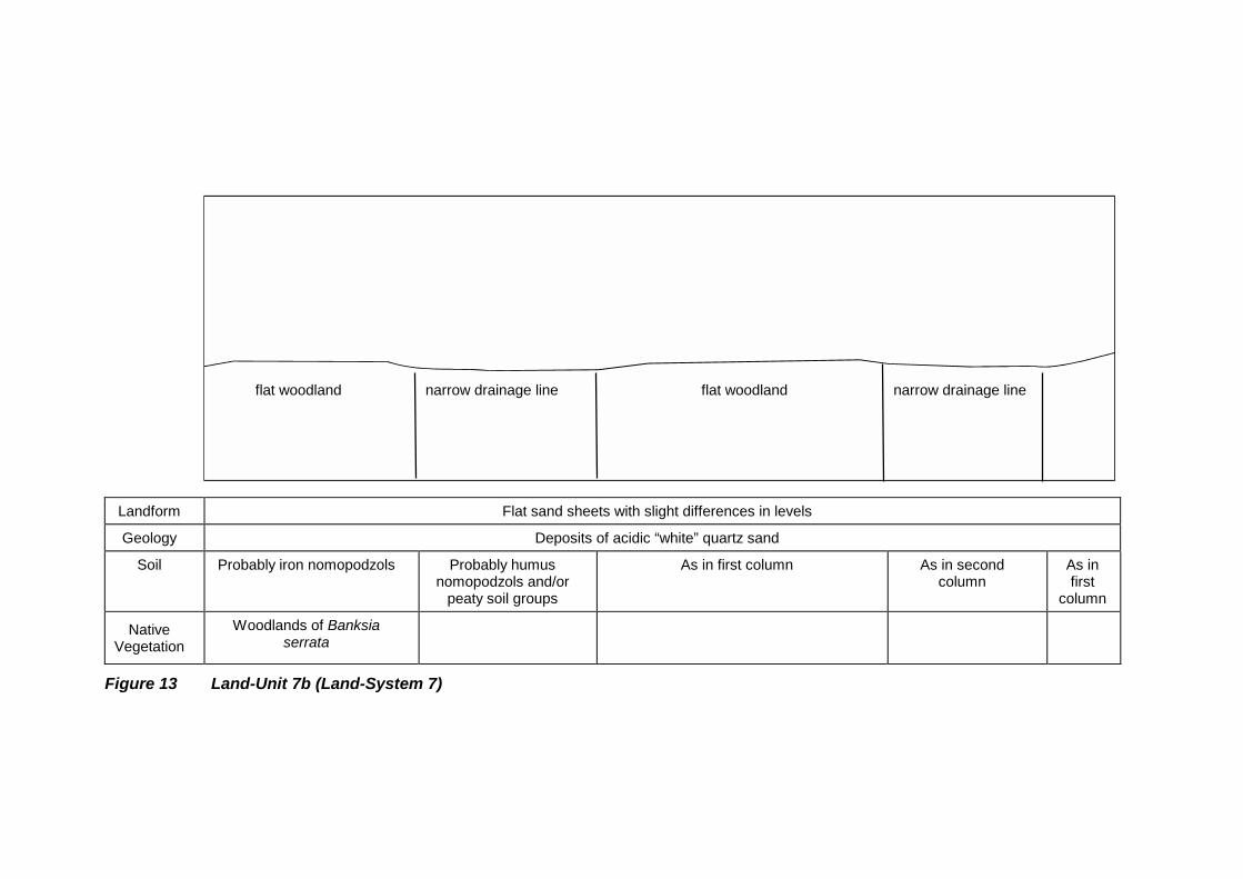
Landform Flat sand sheets with slight differences in levels
Geology Deposits of acidic “white” quartz sand
Soil Probably iron nomopodzols Probably humusnomopodzols and/or
peaty soil groups
As in first column As in secondcolumn
As infirst
column
NativeVegetation
Woodlands of Banksiaserrata
Figure 13 Land-Unit 7b (Land-System 7)
flat woodland narrow drainage line flat woodland narrow drainage line
2.2.3 Land-System 8
Like Land-Systems 6 and 7, this land-system is of built up deposits of white acidic sandsin which nomopodzols have developed. Also, like Land-Systems 6 and 7, there are twodominant and widespread plant communities that can be regarded as more or lessreliable indicators of the nomopodzols. These communities are a stunted (less than 0.5metres high) treeless heath of species listed previously under Land-System 6, andwoodland of B. serrata with X. australis, a dominant member of the heath ground flora.
Land-System 8 differs from the previous two land-systems mainly in the lack of sanddunes and in the fact that the sand sheets are sloping against the sides of granite hillsand mountains. It is divided into Land-Units 8a, 8b and 8c as follows.
Land-Unit 8a
This land-unit occurs as a number of scattered areas located mainly on northerly andwesterly slopes facing Darby River and in the Picnic Point/Pillar Point/Tidal River area.The environmental features are sand sheets overlying the lower slopes of granite hills andmountains, and some woodlands, such as Pillar Point, that are covered, in the main, bysand sheets with rocky knolls and protruding slopes.
It is believed the sand deposits were blown to their present position by wind rather thancoming directly from the granite hills as alluvial hillwash. The evidence of this is found inthe small size of the sand grains, in the uniformity of size with a consequent narrow areaof size variation, in the spherical to sub-spherical shape of the grains, and in the absenceof plate-like grains of mica. These four properties are the opposite to soils formed ongranite and in material of granitic origin. Further evidence is the clearly defined boundary,or discontinuity, between the sand deposits and the underlying amply weathered granite,an example of which is to be seen at the entrance to the gravel quarry on the road toOberon Saddle car park. The B.serrata heath woodland is restricted to the areas north ofthe Darby Saddle where there are areas of treeless heath.

Landform Sloping sand sheet
Geology Wind-blown deposits of acidic “white” quartz sand
Soil Iron and humus nomopodzols
NativeVegetation
Two communities:
1. Stunted heath composed mainly of Allocasuarina pusilla, Banksia marginata, Leptospermummyrsinoides, L. juniperinum, Correa reflexa, Xanthorrhoea australis, X. minor, Isopogonceratophyllus, Hypolaena fastigiata.
2. Heath woodland of B. serrata with a heath ground flora of the above species, of whichAllocasuarina pusilla and X. australis are dominant.
Lower slope of granite hill ormountain in Land-System 1
Figure 14 Land Unit 8A of Land-System 8
sand
granite

Land-Unit 8b
Land-Unit 8b differs from the previous land-unit in that the sloping sand sheets surroundand almost cover low granite hills. The highest parts of the hills appear as rocky knollsand prominences (see Figure 15). Again, it is thought that the sand deposits are wind-blown because the physical and chemical properties of the sand grains are very similar tothose of the sand grains in Land-Unit 8a. A minor and less important difference betweenthe two land-units is that a heath woodland of B. serrata (dominant) and E. obliqua (sub-dominant) is widespread throughout Land-Unit 8b. This plant community is confined toand indicative of the nomopodzols. There are also areas of treeless heaths which aremainly wet heaths confined to drainage lines between the granite outcrops.
Land-Unit 8b occurs as a number of separate areas across the northern part of thePromontory, and a good example can be found around and beyond the first gate acrossthe road to Five Mile Beach.

Landform Sloping sand sheets with protruding rocky knolls
Geology Acidic “white” quartz sand,probably wind-blown
Granite Sand Granite Sand
Soil Iron nomopodzol Duplex Iron nomopodzol, humusnomopodzol in drainage line
Duplex Iron nomopodzol
NativeVegetation
Heath woodland of B. serrata andE. obliqua, with a heath ground floracomposed mainly of X australis,X. minor, Leptospermummyrsinoides, Epacris impressa,Pteridium esculentum, Allocasuarinapusilla.
Dry scrub Heathdrainage
line
Dry scrubdominated byE. obliqua andE. baxteri
Figure 15 Land-Unit 8b (Land-System 8)
granite

Land-Unit 8c
Land-Unit 8c takes in the lowermost slopes of Vereker Range on both sides, to the east andwest. Environmental features are summarised in Figure 16, although more time is needed tostudy the land-unit in greater detail.
The land-unit differs from Land-Unit 8a in at least two features. Firstly, the sloping sheets ofsand are deeply dissected by several creeks to form an undulating topography across the slope,and secondly, there is greater movement of surface and sub-surface water down the slope asindicated by numerous seepage lines, the dominance of heath species (e.g. Melaleucasquarrosa), favouring wetter sites and the deeper and darker A1 soil horizons formed of higheramounts of organic matter.
The creek channels are narrow and deep, and support a dry sclerophyll forest of eucalypts,mainly E. obliqua.
More research is needed on the soils of the slopes. Only one profile was studied and thisshowed a soil with physical properties different to those of the iron and humus nomopodzols inLand-Units 8a and 8b and in Land-Systems 6 and 7. That is, the sand grains are more angularand have a greater range of sizes, and the A horizon is underlain by a clayey sand to sandy claymaterial which could be a separate deposit. This latter feature is not found in the sand depositsin which the nomopodzols have formed because in these the A horizon is underlain by anequally sandy B horizon formed of the same material, which extends to a considerable depth(greater than 30 metres). For these reasons, it is believed the sand sheets in Land-Unit 8ccould be formed of material from the Vereker Range under the action of water rather than ofmaterial blown in from a more distant source by the wind.
The comparatively wet sites afforded by the sloping sand sheets may be a result of the relativelyimpervious clayey subsoil, if this material does occur throughout the land-unit. The wetter siteshave given rise to a number of treeless heath communities dominated by some moisture-tolerant species such as Melaleuca squarrosa. Allocasuarina pusilla, which is dominant in thedrier heath communities of the other land-units and of Land-Systems 6 and 7, is a minor speciesor is absent in this land-unit.

Landform Sloping sand sheet Sloping sand sheet
Geology Acidic “white” quartz sand overlying probablyclay material
As in column 1
Soil Probably regosols and or podsolised duplexsoils.
NativeVegetation
Mostly a short heath with moisture tolerantdominants such as Melaleuca squarrosa. Alsoscattered stands of Banksia serrata.
Short drysclerophyll forestsE. obliqua
Figure 16 Land-Unit 8c (Land-System 8)
CreekCross-section across the slope
Vereker Range
2.3 Chinaman’s Creek Land-Zone
2.3.1 Land-System 9
Chinaman’s Creek Land-Zone incorporates into one mapping unit (Land-System 9) all thelarger of the low-lying wet areas found within the National Park. There is a number of verysmall areas of this kind included as land-components within some of the land-units inYanakie South and Leonard Bay Land-Zones.
Included within the wet areas are narrow drainage lines, swamps and broad wet heaths.The drainage lines and wet heaths are covered with a dense heath vegetation of wet-tolerant species such as Melaleucas.
The soils of the drainage lines, wet heaths and swamp margins are high in organic matterand many of them are probably peats. Parsons (1966), in his intensive study of theecology of the Tidal River area recognised four groups of soils with high levels of organicmatter namely sandy peats, amorphous peats, fibrous peats and salty soils on the tidalflats. These are briefly described in Section 3.1.2.
No time was devoted to the wet areas during the field work and a considerable amount ofstudy is needed to describe them in detail. In the absence of such a close study, the land-zone was assumed to have one land-system (Land-System 9), however it may be thatfurther land-systems could be recognised in any future work. Also, any recognition ofvariations within the land-systems would allow land-units to be described and delineated.

3 DESCRIPTION OF THE SOIL GROUPS RECOGNISED
3.1 Soils of the Deep Sand Deposits
3.1.1 Soils associated with alkaline sand
(i) Regosol
The regosols show very little differentiation into horizons. There are only slight andgradual changes in their morphological and analytical features down the profile. The mainvariations that do occur are in the amount and depth of accumulation of organic matter inthe surface soil, with consequent small variations in colour and texture from place toplace. The accumulation of organic matter depends on the presence and stability of avegetative cover.
The soil material consists of loose, non-structured sand composed mainly of finely brokensea-shells (60-70 per cent), with quartz grains (40-30 percent.). The sand is alkaline withpH values of 8 and 9. The characteristic colour when dry is ‘pale yellow’.
A typical profile is given, described on the fore-dune at Tidal River where there is a stabledry scrub of Leptospermum laevigatum, Allocasuarina verticillata and Leucopogonparviflorus.
0-90 cm dark greyish brown (10 YR 3/2 moist) sand; single grain; loose; organicmatter present; pH 8.1
90-120 cm light brown (10 YR 5/3 moist) sand; single grain; loose; organic matterabsent
120-150 cm light yellowish brown (10 YR 6/4 moist) sand; single grain; loose; pH8.7the third horizon continues for metres and typifies the soil group.
The regosols are found mostly on large calcareous sand dunes, which are mapped asLand-System 4. The calcareous sand of which the regosols are composed also underliesmuch of the area of ‘red’ iron leptopodzol included in Land-System 5.
(ii) Terra rossa and rendzina
These two soil groups have similar properties. Essentially, terra rossas are ‘red’ soilsformed on dune limestone, and rendzinas are dark brown to black soils formed on dunelimestone. This difference in colour is usually the biggest and most consistent difference.Other morphological features and the analytical features are generally quite similar.
In many sites, the soil is shallow (less that 0.5 metres) and abruptly overlies the dunelimestone. Pieces of broken limestone may lie in the soil. Rendzinas in some sites arecomparatively deep, up to 1.5 metres. Both soils are composed of a mixture of brokensea-shells and quartz grains, although there is more quartz than sea-shells, and they areslightly alkaline to moderately alkaline. There is little change in the soil features down theprofile.

A typical rendzina profile is given, described on a dune of dune limestone where there is adry scrub of Banksia integrifolia, Leptospermum laevigatum, Leucopogon parviflorus,Acacia longifolia, Allocasuarina verticillata.
0-15 cm dark brown (7.5 YR 3/2 moist) sand; very friable; weak structure; pH 7.2
15-45 cm dark brown (7.5 YR 3/2 moist) sand; loose; single grain; pieces of brokenlimestone gradually changing to massive dune limestone
A typical terra rossa profile is given, described on a dune of dune limestone where there isa woodland of Banksia integrifolia
0-15 cm brownish red (5 YR 4/6 moist) sand; weak structure; very friable; pH 8.2;pieces of broken limestone
15+ cm dune limestone
The dunes on which the terra rossas and rendzinas occur are included in Land-System 5which lies in the area bounded on the south by Darby River, on the east by the main road,on the north by Cotter Lake and on the west by the sand dunes along the coast.
(iii) Iron leptopodzol
Leptopodzols are included in the podzol group of soils, although they have not beeninfluenced by the podzolising processes to the same extreme degree as the typical ornormal podzols (later referred to as nomopodzols). Thus the A2 horizon is not bleachedbut has a definite colour, and there is no sudden change to a brown or yellow B horizon.
Like the terra rossas, the iron leptopodzols at Wilson’s Promontory are ‘red’ sands, butare deeper, composed solely of quartz grains and are slightly acid to neutral (pH 6.6 -7.0). They have not formed directly on dune limestone but in deposits of windblown sandthat are believed to have originated from the limestone dunes. The upper few centimetresare darkened by organic matter and the reddest soil is found in the subsurface belowabout 30 centimetres. At most sites, the ‘red’ sand overlies a light yellowish browncalcareous sand composed of a material closely similar in composition to that of theregosol described above. The depth of the ‘red’ sand varies from about 45 to 90centimetres.
A typical profile is given below, described on the side of a sand dune on the main road,650 metres south of the start of the Five Mile Road. The vegetation is a woodland ofBanksia integrifolia with a ground flora dominated by dense bracken.
0-5 cm dark brown (7.5 YR 4/2 moist) loamy sand; moderate structure; veryfriable; organic matter present
5-20 cm brown (7.5 YR 5/4 moist) sand; single grain; very friable; organic matterpresent
20-45 cm reddish brown (5 YR 4/4 moist) sand; single grain; loose; organic matterabsent; pH 7.0
45-90 cm yellowish red (5 YR 4/8 to 5/8 moist) sand; single grain; loose
90-150 cm strong brown (7.5 YR 5/6 moist) sand; single grain; loose; graduallybecoming light yellowish brown (10 YR 5/6 moist) sand; pH 8.5
The iron leptopodzols occur in Land-Systems 5 and are represented well in Land-Unit 5c.

3.1.2 Soils associated with acidic sand
(i) Nomopodzol
The nomopodzols within the National Park are highly podzolised soils formed in deepdeposits (more than 3.0 metres) of quartz sand. They show marked profile developmentwith clearly defined A and B horizons. The A horizon is usually between 0.75 metres and1.8 metres in depth and is bleached to ‘white’ or very light grey except for theaccumulation of organic matter at the surface which forms a thin dark grey A1 horizon.There is a sudden change to a B horizon of yellow, yellowish brown and brown sand. Thisboundary is usually very irregular with tongues of A horizon penetrating many centimetresinto the B horizon. The nomopodzols are moderately to highly acidic (pH 5.9 - 4.0).
These soils are subdivided into iron nomopodzols and humus nomopodzols. The ironnomopodzols are as described whereas the humus nomopodzols are identified by auniform zone of dark brown (‘coffee’) humic sand forming a B1 horizon at the boundarybetween the A and B horizons. In wetter sites, this dark brown sand is cemented to forma hardpan of coffee rock. Below the B1 horizon, the B2 horizon continues for some depthas a yellowish brown, yellow or brown sand.
The following profile of an iron nomopodzol was described on a sand dune on the edge ofthe Tidal River camping area on a foot track leading to Oberon Bay. The vegetation is astunted (less than 0.6 metres high) heath with Allocasuarina pusilla and Banksiamarginata as the dominant species.
A1 0-5 cm grey (10 YR 5/1 moist) sand; weak structure; very friable; organic matterpresent.
A2 5-75 cm and 120 cmlight grey (10 YR 6/1 moist) sand; cm single grain; loose; organic matterpresent in small amount; pH 5.3 at 15 - 20 cm gradually becoming white(10 YR 7/1 moist) sand; single grain; loose; organic matter absent.
B1 75 cm and 120-150 cmyellowish brown (10 YR 5/4 moist) sand; single grain; loose; pH 5.6.The sand continues for metres.
The nomopodzols occur in Land-Systems 6, 7 and 8, which together form the LeonardBay Land-Zone. The nomopodzols in the dunes of Land-Unit 6A form a sequence of soiland parent material with the regosols, terra rossas, rendzinas and iron leptopodzolsassociated with the calcareous sand and dune limestone in Land-Systems 4 and 5. Thissequence is very similar to the one in the south-west corner of Victoria, between Portlandand Nelson, which is described by Gibbons and Downes in their book A Study of the Landin South-Western Victoria.
(ii) Regosol
It is not certain whether the soils described as acidic regosols are actually regosols or anunusual form of humus nomopodzol, or whether in fact both soils exist.
The soils in question are found in very large sand dunes around Squeaky Beach, PicnicPoint and Whisky Bay. Many of these dunes are formed of what appears to be a uniform,undifferentiated quartz sand which is regarded as a regosol. The sand is both white(10 YR 8/2 moist), as at Squeaky Beach, and cream (10 YR 6/3 moist), as at Picnic Point.However, also at Picnic Point there is exposed in two badly eroded dunes a massive zoneof ‘coffee rock’ about one metre thick and at considerable depth within the dunes. Thesand above and below the coffee rock is identical to the regosol sand of the other dunesin the area. The presence of the coffee rock indicates that the material composing thedunes has been podzolised. Apart from deep boring, the only way of detecting the coffeerock is to observe it exposed deep within the dunes in large wind-excavated ‘blow-outs.’There are several dunes damaged in this way but no zone of coffee rock is visible and sothe soil is regarded as a regasol.
(iii) Soils high in organic matter
No time was spent in studying the soils of the swamps and drainage lines, however it isthought that they can be conveniently grouped together under the above heading. In hisstudy of the ecology of the Tidal River area, Parsons (1966) recognised four groups ofsoils with high levels of organic matter. The first group contains peaty sands and sandypeats, which are made up of partly decomposed amorphous remains of Melaleucaspecies and a clearly visible sand content. The second group contains amorphous peats,which are similar to the first group but are higher in organic matter and have no visiblesand content. The third group contains fibrous peats, which are composed of sedgeresidues, and the fourth group contains organic soils on the tidal flats and these consist ofsandy peat with some fibrous material.
3.2 Soils Formed on Granite
Little time was spent in the granite areas and only the following two soil groups to followwere described. There are probably other groups as well.
(i) Podzolised duplex soil
The term ‘duplex’ refers to the dual, or double nature, of the profile, namely, acomparatively shallow A horizon of sandy material abruptly overlying a subsoil of clay.The term ‘podzolised’ refers to the podzolised A horizon which, in the deeper examples, isaccompanied by a thin zone of ‘coffee brown’ humus deposit at the boundary between theA and B horizons. The shallower A horizons (around 30 centimetres in depth) do not havethe humus deposit. The A horizon has large amounts of angular quartz stones andgravel, and also it is divided into a dark grey A1 horizon of organic matter accumulationand a light grey A2 horizon. The clay subsoil has colours of yellowish brown, brown,greyish brown and red, and is gravelly with quartz stones. The entire profile is highlyacidic (pH 4.0-5.5).
The following profile was described at the car park at Oberon Saddle. There is a dryscrub of E. baxteri and E. willisii , Xanthorrhoea australis, Leptospermum myrsinoides,L. continentale and Banksia marginata.
A1 0-10 cm dark grey gravelly loamy sand; weak structure; friable; small stonesof quartz
A2 10-45 cm light brownish grey (10 YR 5/2-6/2 moist) gravelly sand; single grain;soft; small stones of quartz pH 4.4
B1 45-50 cm dark brown (7.5 YR 3/2 moist) gravelly sand; single grain; loose;small stones of quartz
B2 50-80 cm strong brown (7.5 YR 5/6 and 5/8 moist) clayey gravelly sand;cemented and structureless; hard
B3 80-120 cm mottles of yellowish brown, brown and red gravelly clay;friable; pH 4.2
(ii) Acid brown earth
No profile of this group was formally described. The most evident feature of the soils inthis group is the strong brown colour throughout most of the profile. Also, these soilshave more clay and less sand than the podzolised duplex soils and there is a gradualincrease in clay content with depth rather than a sudden and large increase. The subsoilis a strong brown clay.

APPENDIX 1
Comparison of the Australian Soil Classification, 1996 (Isbell) with the existing soilclassification (based on the scheme of Hallsworth, Costin and Gibbons (1953)).
Classified by Sibley based on Hallsworth,Costin & Gibbons.
Australian Soil Classification (Isbell)
A. SOILS OF THE DEEP SAND DEPOSITS1. Soils associated with alkaline sand(i) Regosols, as described Rudosol: Shelly
family criteria: E, K and/orTenosol: Chernic-Leptic, Shelly, Melanicfamily criteria: D, E, K, K, X
(ii) Terra rossa, as described Calcarosol: Calcic, Petrocalcic, Cetericfamily criteria: B, E, K, K, T
and Rendzina, as described Calcarosol: Calcic, Petrocalcic, Cetericfamily criteria: B. E, K, K, U
(iii) Iron leptopodzol, as described Tenosol: Orthic, Regolithic, Basicfamily criteria: A, E, K, K, W
2. Soils associated with acidic sand(i) Nomopodzol - iron, as described Tenosol: Bleached-Orthic, Regolithic, Acidic
family criteria: A, E, K, K, Xand Nomopodzol – humic, not fully described Podosol: Semiaquic, Pipey, Parapanic
family criteria: A, E, K, K, X
(ii) Regosol, not fully described Rudosol: Arenic, Acidicfamily criteria: A, E, K, K, X or
Podosol: Semiaquic, Humosesquic, Parapanicfamily criteria: A, E, K, K, X
(iii) Soils high in organic matter, notdescribed
Organosols,Tenosols
B. SOILS FORMED ON GRANITE(i) Podzolised duplex soils, as described Podosol: Semiaquic, Humic, Parapanic
family criteria: B, G, K, M, W or
Kurosol: Brown, ?, Bleached-Mottledfamily criteria: B, G, K, M, W
(ii) Acid brown earth not described Dermosols: Brown
This comparison is based on existing information in the Wilson’s Promontory report bySibley with no soil chemical information apart form pH (water) values. Alternatives aregiven where there is some doubt as to the diagnostic criteria which may vary within a mapunit. The use of the term podzol or podzolised has been more tightly defined in theAustralian Soil Classification and hence the classification into other orders besidespodosols, particularly tenosols.
The concepts and terms discussed in this report are based on those of Hallsworth, Costinand Gibbons (1953), which are based on descriptions of soils in New South Wales. Thepaper cited is the sixth in a series of seven studies of pedogenisis in New South Wales.

APPENDIX 2
Laboratory Data
Profile Lab no. Soil Type Horizon Gravel (%) pH(water) EC(dSm-1)
0431 65/1696 Regosol A11 0 8.1 0.200
0431 65/1697 Regosol A13 0 8.7 0.220
0432 65/1698 Iron Nomopodzol A2 0 5.3 0.095
0432 65/1699 Iron Nomopodzol B1 0 5.6 0.040
0433 65/1700 Iron Nomopodzol A2 <1 4.5 0.092
0433 65/1701 Iron Nomopodzol A2 <1 5.2 0.052
0433 65/1702 Iron Nomopodzol B1 <1 5.7 0.044
0434 65/1703 PodzolizedDuplex
A2 14 4.4 0.091
0434 65/1704 PodzolizedDuplex
B4 6 4.2 0.190
0435 65/1705 Regosol A1 0 5.2 0.047
0435 65/1706 Regosol A2 0 5.0 0.027
0436 65/1707 Rendzina A1 1 7.2 0.190
0437 65/1708 Red, iron B 0 7.0 0.110
0437 65/1709 Leptopodzol 2B2 <1 8.5 0.160
0438 65/1710 Terra Rossa A1 4 8.2 0.260
0439 65/1711 Regosol A1 0 8.4 0.110
0439 65/1712 Regosol A2 0 9.0 0.091

REFERENCESGibbon, F. R. and Downes R. G. (1964). A study of the land in South Western Victoria.
Soil Conservation Authority Victoria.
Hallsworth, E. G., Costin, A. B. and Gibbons, F. R. (1953). Studies in pedogenesis inNew South Wales. VI. On the classification of soils showing features of podzolmorphology. Journal of Soil Science, Vol. 4, No. 2.
Isbell, R. F. (1996). The Australian Soil Classification. CSIRO Publishing, Melbourne.
Parsons. R. F. (1966). The soils and vegetation at Tidal River, Wilson’s Promontory.Royal Society of Victoria.
Ross, J. H. (1996) A Census of the Vascular Plants of Victoria. Fifth edition. Publishedby the National Herbarium of Victoria, Royal Botanic Gardens, Birdwood Avenue,South Yarra, Victoria, 3141, Australia
Rowan J. (1990) Land systems of Victoria. Department of Conservation & Environmentand Land Conservation Council.
Sibley, G. T (1966). A study of the lands at Wilson’s Promontory Soil ConservationAuthority, Victoria.
NOTES
The Eucalyptus species identified as Eucalyptus vitrea in the original report is now knownas Eucalyptus willisii (Shining Peppermint). However, it is now thought that this species isactually of a Tasmanian provenance and as such may well be identified in the future as E.nitida. (Cameron,1 pers. comm.).
1 D. Cameron (Senior Botanist, Biodiversity Directorate, Department of Natural Resources and Environment)

BOTANICAL NAME CHANGES OF WILSON’S PROMONTORY VEGETATION
The following botanic list comprises the names of the native and naturalised vascularplants recognised as occurring in Wilson’s Promontory who’s names have been alteredsince this report was first published in 1966. (Ross, 1996).
Was Now Future
Acacia sophorae Acacia longifolia
Bedfordia salicina Bedfordia arborescens
Casuarina paludosa Allocasuarina paludosa
Casuarina pusilla Allocasuarina pusilla
Casuarina stricta Allocasuarina verticillata
Eucaluptus bicostata Eucalyptus globulus
Eucaluptus vitrea Eucalyptus willisii Eucalyptus nitida
Hypolaena sp. Hypolaena fastigiata
Leptospermum juniperinum Leptospermum continentale
Scirpus nodosus Isolepis nodosa
As this report was originally published in 1966, all measurements have been converted tometric.