Embed Size (px)
DESCRIPTION
curso de estratigrafia
Citation preview

ESTRATIGRAFÍA

2
StratigraphyThe STUDY OF THE VERTICAL SEQUENCE OF THE LAYERED ROCKS AND THE LATERAL VARIATIONS OF INDIVIDUAL BEDS ON A REGIONAL BASIS (Baars & Stevenson, 1991).
AGI’s Dictionary of Geological Terms in 1976 defines stratigraphy as that BRANCH OF GEOLOGY THAT TREATS THE FORMATION, COMPOSITION, SEQUENCE AND CORRELATION OF STRATIFIED ROCKS as part of the earth’s crust. Sequence stratigraphy is used to interpret the origin of these stata.

3
Geologic time scaleA CHRONOLOGICAL CHART OF THE STAGES AND AGES OF
EVENTS in the history of the Earth, from its initial formation to present,
that has been constructed on the basis of the rock record. As is the typical
natural position of rocks, the oldest event is at the bottom of the chart and
the youngest is at the top. Both absolute and relative ages of rocks and
fossils supplement interpretations from rocks. The vastness of geologic
time and the slowness of geological processes are difficult to capture in a
simple chart
StratigraphyThe study of the history, composition, relative ages and distribution of strata, and the interpretation of strata to elucidate Earth history. The comparison, or correlation, of separated strata can include study of their lithology, fossil content, and relative or absolute age, or lithostratigraphy, biostratigraphy, and chronostratigraphy.
4
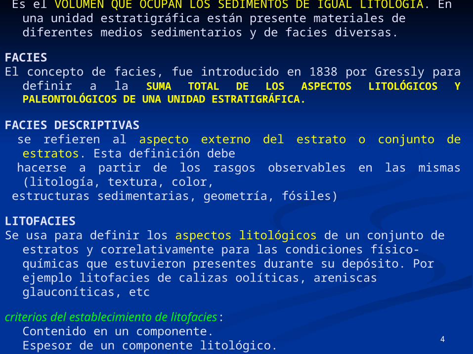
UNIDAD ESTRATIGRÁFICA Es el VOLUMEN QUE OCUPAN LOS SEDIMENTOS DE IGUAL LITOLOGÍA. En una
unidad estratigráfica están presente materiales de diferentes medios sedimentarios y de facies diversas.
FACIESEl concepto de facies, fue introducido en 1838 por Gressly para definir a la SUMA
TOTAL DE LOS ASPECTOS LITOLÓGICOS Y PALEONTOLÓGICOS DE UNA UNIDAD ESTRATIGRÁFICA.
FACIES DESCRIPTIVAS se refieren al aspecto externo del estrato o conjunto de estratos. Esta definición debe hacerse a partir de los rasgos observables en las mismas (litología, textura, color, estructuras sedimentarias, geometría, fósiles)
LITOFACIESSe usa para definir los aspectos litológicos de un conjunto de estratos y
correlativamente para las condiciones físico-químicas que estuvieron presentes durante su depósito. Por ejemplo litofacies de calizas oolíticas, areniscas glauconíticas, etc
criterios del establecimiento de litofacies:Contenido en un componente.Espesor de un componente litológico.Relación entre dos, tres, o cuatro componentes.

5
Factores genéticos que condicionan el cambio de litofacies:-Subsidencia de la cuenca y su relación con la velocidad de sedimentación.-Factores climáticos, que controlan la cantidad y calidad de los aportes a una cuenca.-Factores ambientales, en los que se incluyen los que regulan la distribución de los aportes, dentro de una cuenca.
BIOFACIES.La biofacie, es el complementario y se refiere a los aspectos paleontológicos y a las condiciones biológicas presentes durante su depósito. Ejemplo: facies de gasterópodos, facies de carófitas, etc.
FACIES SÍSMICASEl término facies sísmicas, se utiliza para denominar al conjunto de propiedades observables en un perfil sísmico para un estrato o conjunto de estratos. Las propiedades son: configuración, amplitud, frecuencia, continuidad, velocidad de intervalo, etc. y permite diferenciar tipos de materiales y geometría de las superficies de estratificación.El volumen ocupado de los materiales de una misma facie sísmica es denominado unidad litosísmica.

6
CHRONOSTRATIGRAPHY
The study of the ages of strata. The comparison, or correlation, of
separated strata can include study of their relative or absolute ages
ABSOLUTE AGE The measurement of AGE IN YEARS. The determination of the absolute age of rocks, minerals and fossils, in years before the present, is the basis for the field of geochronology. The measurement of the decay of radioactive isotopes, especially uranium, strontium, rubidium, argon and carbon, has allowed geologists to more precisely determine the age of rock formations. Tree rings and seasonal sedimentary deposits called VARVES can be counted to determine absolute age. Although the term implies otherwise, "absolute" ages typically have some amount of potential error and are inexact. Relative age, in contrast, is the determination of whether a given material is younger or older than other surrounding material on the basis of stratigraphic and structural relationships, such as superposition, or by interpretation of fossil content.
7
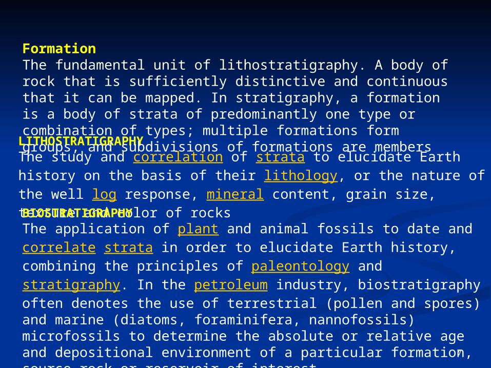
LITHOSTRATIGRAPHYThe study and correlation of strata to elucidate Earth history on the basis of their lithology, or the nature of the well log response, mineral content, grain size, texture and color of rocks
BIOSTRATIGRAPHYThe application of plant and animal fossils to date and correlate strata in order to elucidate Earth history, combining the principles of paleontology and stratigraphy. In the petroleum industry, biostratigraphy often denotes the use of terrestrial (pollen and spores) and marine (diatoms, foraminifera, nannofossils) microfossils to determine the absolute or relative age and depositional environment of a particular formation, source rock or reservoir of interest
Formation The fundamental unit of lithostratigraphy. A body of rock that is sufficiently distinctive and continuous that it can be mapped. In stratigraphy, a formation is a body of strata of predominantly one type or combination of types; multiple formations form groups, and subdivisions of formations are members

8
GEOCHRONOLOGY The study of the relative or absolute age of rocks, minerals and fossils. Absolute age is the measurement of age in years, but "absolute" ages typically have some amount of error and are inexact. Relative age, in contrast, is the approximate age of rocks, fossils or minerals made by determining the age of the material relative to other surrounding material.
ANGULAR UNCONFORMITYA surface that separates younger strata from eroded, dipping, older strata and represents a gap in the geologic record

9
Angular conformityAngular conformity: younger sediments rest : younger sediments rest upon the eroded surface of tilted or folded older upon the eroded surface of tilted or folded older rocks.rocks.
DisconformityDisconformity:: contact between younger and contact between younger and older beds is marked by a visible, irregular or older beds is marked by a visible, irregular or uneven erosional surface.uneven erosional surface.
ParaconformityParaconformity:: beds above and below the beds above and below the unconformity are parallel and no erosional unconformity are parallel and no erosional surface is evident; but can be recognized based surface is evident; but can be recognized based on the gap in the rock record.on the gap in the rock record.
NonconformityNonconformity: develops between : develops between sedimentary rock and older igneous or sedimentary rock and older igneous or metamorphic rock that has been exposed to metamorphic rock that has been exposed to erosion.erosion.

10
ESTRATIGRAFÍA
TECTÓNICA DE PLACAS
REGIONAL
CAMPO
YACIMIENTO

11
TECTONICA DE
PLACAS

12
ESTRATIGRAFÍA A
NIVEL DE REGIONAL

13
ESTRATIGRAFÍA A NIVEL DE REGIONAL

14

15

16
Jurassic stratigraphic zonation
Up
per
Jura
ssic
jst6a
jst1
jst10
jst11
jst12
jst2
jst3
jst4a
jst5b
JST
jst6b
jst7a
jst7b
jst8
jst9
JSK
jsk1ajsk1b
jsk2
jsk3jsk4
jsk5
jsk6ajsk6b
JSOX
jsox1
jsox2
StratigraphicLayer
Western AtlasCunduacan -
Oxiacaque Study
jst4b
jst5a
JST1
JST2
JST3
JST4
JsKmm
JsOxf
JST5
JsCall
Mid
dle
Ju
rassic JSCAL
jscal1
jscal2
jscal3
jscal4
StratigraphicLayer
Western AtlasCunduacan -
Oxiacaque Study
Schlumberger H-RT
BermudezComplex
Integrated StudyStratigraphic
Layer
Schlumberger H-RT
BermudezComplex
Integrated StudyStratigraphic
Layer

17 Cretaceous stratigraphic zonation
Up
per
Cre
taceou
sM
idd
le C
reta
ceou
sLow
er
Cre
taceou
s
KS2.5
KS 0
KS 1.5
KS 3
KS 5
KS 1
KS 2
KM
KI3
KI4
KI2
KI1
KI2.5
KI5
KM
KI
KImd
KIls
km1
km2
km3km4
km5km6
km7
km8km9
KI
ki2
KM
ki1
StratigraphicLayer
Western AtlasCunduacan -
Oxiacaque Study
KSdf4
KSdwf4
KS3
KSpt3
KSdwf3
KS2
KSst2
KSdwf2
KS1KSst1
KSdwf1
Intera Samaria -Iride Study
KS4
StratigraphicLayer
KSpt1
KS
ks1a
ks1b
ks2
ks2aks2b
ks2c
ks2d
ks2e
ks3
ks4ks4a
ks1
KS
ks4b
Schlumberger H-RT
BermudezComplex
Integrated StudyStratigraphic
Layer
KIcd
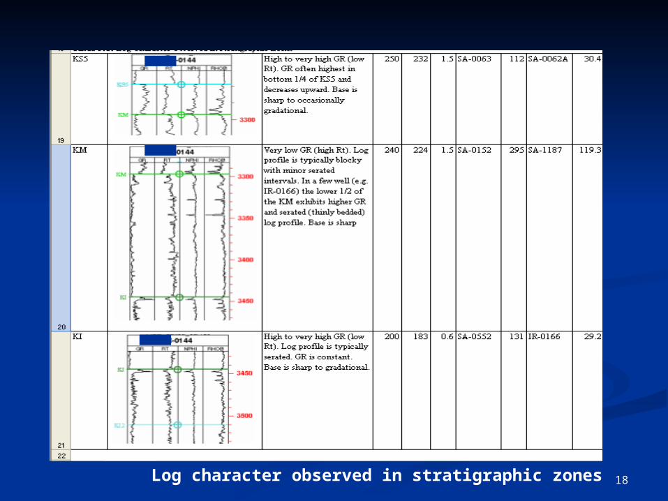
18 Log character observed in stratigraphic zones

19
Jurassic Tithonian talus breccia lithofacies. A) Talus debris flow bed about 1.5 m thick encased in laminated marl. B) FMI showing stacked cycles of laminated marl interbedded with talus debris packstones. C) Depositional model for debris flow beds encased in basinal limestone facies (Cook et al., 1972)
A
Laminated marl
Talus debris
Laminated marl
Laminatedmarl
CB
Laminatedmarl
Talus debris
Talus debris

20
Lower Cretaceous talus breccia lithofacies. A) Talus debris flow breccia composed of lithoclast packstone. B) Talus breccia of lithoclast grainstone. Clast supported breccia of dolomitized mudstone clasts cemented with crystalline dolomite. C) Talus breccia of lithoclast packstone. Mudstone lithoclasts in a laminated marl matrix. D) Talus breccia of lithoclast wackestone. Mudstone clasts are suspended in a micrite matrix.
Cunduacan-41; 4301 m Cunduacan-41; 4205 mCunduacan-14; 4850-4856 m
Talus debris flow
Packstone breccia
A
CB D
21

22
23
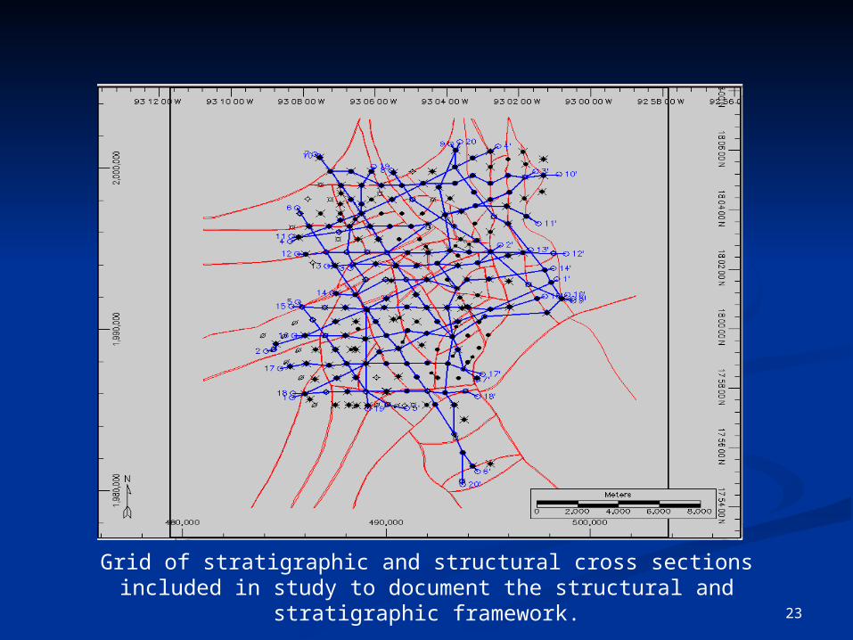
Grid of stratigraphic and structural cross sections included in study to document the structural and stratigraphic framework.
24
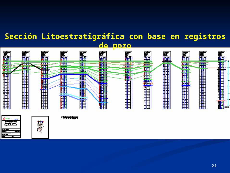
Sección Litoestratigráfica con base en registros de pozo

25
Sección Litoestratigráfica A-A´
26
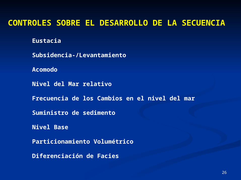
CONTROLES SOBRE EL DESARROLLO DE LA SECUENCIA
Eustacia
Subsidencia-/Levantamiento
Acomodo
Nivel del Mar relativo
Frecuencia de los Cambios en el nivel del mar
Suministro de sedimento
Nivel Base
Particionamiento Volumétrico
Diferenciación de Facies

27

28
29

30
31

32

33

34

35
36

37

38

39
Retrogradation
The movement of coastline land-ward in response to a transgression. This can occur during a sea-
level rise with low sediment flux. Retrogradational stacking patterns of parasequences refer to
patterns in which facies become progressively more distal when traced upward vertically
El movimiento de la línea de la costa hacia tierra adentro en respuesta a una transgresión. Esto
puede ocurrir durante una subida del nivel del mar con flujo bajo del sedimento. Retrogradational
que apila patrones de parasequences refiere a los patrones en los cuales las facies llegan a ser
progresivamente más distal cuando están remontadas hacia arriba verticalmente

40
AggradationVertical build up of a sedimentary sequence. Usually occurs when there is a relative rise in sea level produced by subsidence and/or eustatic sea-level rise, and the rate of sediment influx is sufficient to maintain the depositional surface at or near sea level (i.e. carbonate keep-up in a HST [highstand Systems Tract] or clastic HST). Occurs when sediment flux = rate of sea-level rise. Produces Aggradational stacking patterns in parasequences when the patterns of facies at the top of each parasequence are essentially the same
Acumulación vertical de una secuencia sedimentaria. Ocurre generalmente cuando hay una subida relativa del nivel del mar producido por el hundimiento y/o subida eustatic del nivel del mar, y el índice de la afluencia del sedimento es suficiente mantener la superficie deposicional en o cerca del nivel del mar (es decir el carbonato guarda -para arriba en un HST [ zona de los sistemas del highstand ] o HST clástico). Ocurre cuando flujo del sedimento = índice de la subida del nivel del mar. Produce Aggradational que apila patrones en parasequences cuando los patrones de facies en la tapa de cada parasequence son esencialmente iguales

41
ProgradationLateral outbuilding, or progradation, of strata in a sea-ward direction. Progradation can occur as a result of a sea-level rise accompanied by a high sediment flux (causing a regression). This latter usually occurs during the late
stages of the development of a Highstand Systems Tract and/or an Falling Stage Systems Tract. A Progradational stacking pattern of parasequences refers to the pattern in which facies at the top of each
parasequence becomes progressively more proximal Dependencia lateral, o progradation, de estratos en una dirección de la mar-sala. Progradation puede ocurrir como resultado de una subida del nivel del mar acompañada por un alto flujo del
sedimento (que causa una regresión). Este último ocurre generalmente durante las últimas etapas del desarrollo de una zona de los sistemas de Highstand y/o de una zona de los sistemas de la
etapa que cae. Un Progradational que apila el patrón de parasequences refiere al patrón en el cual la facies en la tapa de cada parasequence llega a ser progresivamente más próxima
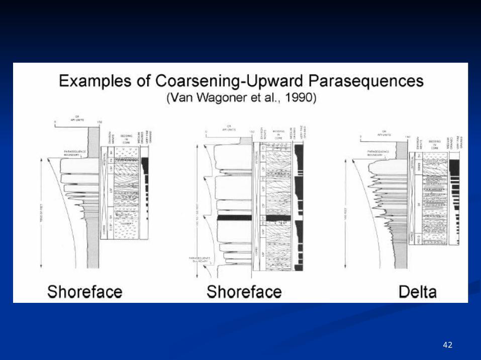
42

43

44

45

46
EJERCICIOS

47

48

49

50

51

52

53

54