Embed Size (px)
Citation preview
NIST GCR 14-917-29
A Framework to Update the Plan to Coordinate
NEHRP Post-Earthquake Investigations
NEHRP Consultants Joint Venture A partnership of the Applied Technology Council and the
Consortium of Universities for Research in Earthquake Engineering
Disclaimers
This report was prepared for the Engineering Laboratory of the National Institute of Standards and Technology (NIST) under the National Earthquake Hazards Reduction Program (NEHRP) Earthquake Structural and Engineering Research Contract SB134107CQ0019, Task Order 12-478. The contents of this publication do not necessarily reflect the views and policies of NIST or the U.S. Government. This report was produced by the NEHRP Consultants Joint Venture, a joint venture of the Applied Technology Council (ATC) and the Consortium of Universities for Research in Earthquake Engineering (CUREE). While endeavoring to provide practical and accurate information, the NEHRP Consultants Joint Venture, the authors, and the reviewers assume no liability for, nor express or imply any warranty with regard to, the information contained herein. Users of information contained in this report assume all liability arising from such use. Unless otherwise noted, photos, figures, and data presented in this report have been developed or provided by NEHRP Consultants Joint Venture staff or consultants engaged under contract to provide information as works for hire. Any similarity with other published information is coincidental. Photos and figures cited from outside sources have been reproduced in this report with permission. Any other use requires additional permission from the copyright holders. Certain commercial software, equipment, instruments, or materials may have been used in the preparation of information contributing to this report. Identification in this report is not intended to imply recommendation or endorsement by NIST, nor is it intended to imply that such software, equipment, instruments, or materials are necessarily the best available for the purpose. NIST policy is to use the International System of Units (metric units) in all its publications. In this report, however, information is presented in U.S. Customary Units (inch-pound), as this is the preferred system of units in the U.S. earthquake engineering industry. Cover image – Damage in the San Francisco Marina district after the 1989 Loma Prieta earthquake (courtesy of J.K. Nakata, U.S. Geological Survey).
NIST GCR 14-917-29
A Framework to Update the Plan to Coordinate NEHRP
Post-Earthquake Investigations
Prepared for U.S. Department of Commerce
National Institute of Standards and Technology Engineering Laboratory
Gaithersburg, MD 20899
By NEHRP Consultants Joint Venture
A partnership of the Applied Technology Council and the Consortium of Universities for Research in Earthquake Engineering
November 2013
U.S. Department of Commerce
Penny Pritzker, Secretary
National Institute of Standards and Technology Patrick D. Gallagher, Under Secretary of Commerce for Standards
and Technology and Director

Participants National Institute of Standards and Technology
John (Jack) R. Hayes, Jr., Director, National Earthquake Hazards Reduction Program Steven L. McCabe, Deputy Director, National Earthquake Hazards Reduction Program
NEHRP Consultants Joint Venture
Applied Technology Council 201 Redwood Shores Parkway, Suite 240 Redwood City, California 94065 www.ATCouncil.org
Consortium of Universities for Research in Earthquake Engineering 1301 S. 46th Street, Building 420 Richmond, California 94804 www.CUREE.org
Joint Venture Management Committee
James R. Harris Robert Reitherman Christopher Rojahn Andrew Whittaker
Joint Venture Program Committee
Jon A. Heintz (Program Manager) Michael Constantinou C.B. Crouse James R. Harris William T. Holmes Jack Moehle Andrew Whittaker
Project Technical Committee
William T. Holmes (Project Director) Jonathan Bray Thomas Holzer Laurie A. Johnson Jack Moehle Sharon Wood
Project Review Panel
Gregory Anderson Michael Blanpied Sergio Breña Michel Bruneau John Filson J. David Frost Marjorie Greene Eric Letvin Michael Mahoney Joy Pauschke Santiago Pujol Kathleen Tierney
Project Manager
Laura Dwelley Samant
NIST GCR 14-917-29

GCR 14-917-29 Preface iii
Preface
Four agencies are included in the National Earthquake Hazards Reduction Program
(NEHRP): the Federal Emergency Management Agency (FEMA), the National
Institute of Standards and Technology (NIST), the National Science Foundation
(NSF), and the U.S. Geological Survey (USGS). The agencies have complementary
but unique roles in NEHRP that extend to their activities in performing field
investigations following earthquakes. In 2002, with support from NSF, the
Earthquake Engineering Research Institute (EERI) conducted a workshop that
examined many of the key post-earthquake investigation issues relevant to NEHRP.
The result was the publication of USGS Circular 1242, The Plan to Coordinate
NEHRP Post-Earthquake Investigations (USGS, 2003), which outlines interactions
that were envisioned for the NEHRP agencies to employ in investigating
earthquakes.
In 2007, the National Institute of Standards and Technology (NIST) awarded a
National Earthquake Hazards Reduction Program (NEHRP) “Earthquake Structural
and Engineering Research” contract (SB1341-07-CQ-0019) to the NEHRP
Consultants Joint Venture, a partnership between the Applied Technology Council
(ATC) and the Consortium of Universities for Research in Earthquake Engineering
(CUREE), to conduct a variety of tasks, including Task Order 12-478 entitled,
“Development of Updated NEHRP Post-Earthquake Investigations Strategy:
Phase I.” The objective of this project was to develop a framework that could be
used to update the plan to coordinate NEHRP post-earthquake investigations,
currently presented in USGS Circular 1242. The result is a series of issues,
documented in this report, ranging from how and when the plan should be updated to
the content and detail of specific elements that should be included in the plan. The
issues, along with their recommended solutions, form a framework that may be used
in the development of an updated plan.
The NEHRP Consultants Joint Venture is indebted to the leadership of Bill Holmes,
Project Director, and to the members of the Project Technical Committee, consisting
of Jon Bray, Tom Holzer, Laurie Johnson, Jack Moehle, and Sharon Wood, for their
contributions in developing this report and the resulting recommendations. The
Project Review Panel, consisting of Greg Anderson, Michael Blanpied, Sergio Breña,
Michel Bruneau, John Filson, David Frost, Marjorie Greene, Eric Letvin, Mike
Mahoney, Joy Pauschke, Santiago Pujol, and Kathleen Tierney, provided critical
review and commentary at key developmental stages of the report. The names and
iv Preface GCR 14-917-29
affiliations of all who contributed to this report are provided in the list of Project
Participants.
The NEHRP Consultants Joint Venture also gratefully acknowledges Jack Hayes
(NEHRP Director) and Steve McCabe (NEHRP Deputy Director) for their input and
guidance in the preparation of this report, Laura Dwelley Samant for ATC Project
Management services, and Ayse Hortacsu and Amber Houchen for ATC report
production services.
Jon A. Heintz
Program Manager
GCR 14-917-29 Table of Contents v
Table of Contents
Preface ................................................................................. iii
List of Tables ......................................................................... vii
1. Introduction ................................................................ 1-1 1.1 Background ..................................................................................... 1-1 1.2 Motivation and Purpose .................................................................. 1-2 1.3 Organization and Content ............................................................... 1-3
2. Issues ........................................................................ 2-1 2.1 Scope, Development, and Maintenance .......................................... 2-2 2.1.1 Issue S1: Scope of the Plan ................................................ 2-2 2.1.2 Issue S2: Timing for Update of the Existing Plan ............. 2-6 2.1.3 Issue S3: Participants in the Development of an
Updated Plan ...................................................................... 2-7 2.1.4 Issue S4: Format of the Plan .............................................. 2-8 2.1.5 Issue S5: Maintaining the Plan ........................................ 2-10 2.2 Coordination ................................................................................. 2-11 2.2.1 Issue C1: Developing Technical Clearinghouses ............ 2-11 2.2.2 Issue C2: Role of the Coordinating Agency for the
NEHRP Post-Earthquake Investigations Program ........... 2-13 2.2.3 Issue C3: Role of the NEHRP Investigations
Coordinator ...................................................................... 2-16 2.2.4 Issue C4: Triggering Coordinated Post-Earthquake
Investigations ................................................................... 2-17 2.2.5 Issue C5: Terminology for Discussing Post-Earthquake
Investigations ................................................................... 2-20 2.2.6 Issue C6: Engaging Non-NEHRP Federal Agencies ....... 2-21 2.2.7 Issue C7: Engaging Regional, State, and Local
Agencies .......................................................................... 2-23 2.2.8 Issue C8: Engaging Non-Governmental
Organizations ................................................................... 2-25 2.2.9 Issue C9: Investigating Effects that are not included
in NEHRP Legislation ..................................................... 2-27 2.2.10 Issue C10: Coordinating with Post-Earthquake
Response and Recovery Operations ................................. 2-29 2.3 Data and Technology .................................................................... 2-32 2.3.1 Issue D1: Using Technology for Post-Earthquake
Reconnaissance Coordination .......................................... 2-32 2.3.2 Issue D2: Using Technology for Data Collection ............ 2-34 2.3.3 Issue D3: Archiving Data ................................................ 2-36 2.4 Funding ......................................................................................... 2-37 2.4.1 Issue F1: Funding for Coordinated NEHRP
Post-Earthquake Investigations ........................................ 2-37
vi Table of Contents GCR 14-917-29
2.5 Site Access .................................................................................... 2-39 2.5.1 Issue A1: Obtaining Permission to Access Restricted
Areas ................................................................................ 2-39 2.5.2 Issue A2: Managing and Coordinating Access for
Non-NEHRP Post-Earthquake Investigators.................... 2-41 2.5.3 Issue A3: Avoiding Interference with Emergency
Response Operations and Emphasizing Personal Safety................................................................................ 2-42
2.6 International Considerations ......................................................... 2-44 2.6.1 Issue I1: Coordinating Investigations of Foreign
Earthquakes ...................................................................... 2-44 2.6.2 Issue I2: Hosting Foreign Post-Earthquake
Investigators of Domestic Earthquakes ............................ 2-46
3. Summary .................................................................... 3-1 3.1 Overview of Issues .......................................................................... 3-1 3.2 Issues of Special Importance ........................................................... 3-3 3.3 Necessary Funding .......................................................................... 3-4
Appendix A: Relevant Resources ............................................... A-1 A.1 List of Relevant Resources ............................................................. A-1 A.1.1 Primary Relevance ............................................................ A-1 A.1.2 Secondary Relevance ........................................................ A-2 A.1.3 Tertiary Relevance ............................................................ A-3 A.2 Selected Passages from Relevant Resources .................................. A-3 A.2.1 USGS Circular 1242 ......................................................... A-4 A.2.2 EERI Collection and Management of Earthquake
Data ................................................................................... A-4 A.2.3 EERI Post-Earthquake Investigation Field Guide ............. A-5 A.2.4 Manual for GEER Reconnaissance Teams ....................... A-5 A.2.5 California Post-Earthquake Information Clearinghouse
Draft Operation Plan ......................................................... A-6 A.2.6 EERI Learning from Earthquakes Program Operations .... A-6 A.2.7 NIST Disaster and Failure Studies Fact Sheet .................. A-6 A.2.8 Report on Engineering Reviews to the American
Society of Civil Engineers ................................................. A-7 A.2.9 Effectiveness of the National Earthquake Hazards
Reduction Program ............................................................ A-7
Appendix B: Standard Nomenclature ........................................... B-1
Acronyms ............................................................................. C-1
References .......................................................................... D-1
Project Participants ................................................................ E-1
GCR 14-917-29 List of Tables vii
List of Tables
Table 2-1 List of Issues ................................................................................... 2-3
Table 3-1 Issues Regarding the Timing and Development of an Updated Plan ................................................................................................. 3-2
Table 3-2 Issues Regarding Scope and Content of an Updated Plan .............. 3-2
Table 3-3 Issues Not Considered to be Part of an Updated Plan ..................... 3-2
Table 3-4 Issues of Special Importance .......................................................... 3-3

GCR 14-917-29 1: Introduction 1-1
Chapter 1
Introduction
1.1 Background
Four agencies comprise the National Earthquake Hazards Reduction Program
(NEHRP): the Federal Emergency Management Agency (FEMA), the National
Institute of Standards and Technology (NIST), the National Science Foundation
(NSF), and the U.S. Geological Survey (USGS). These agencies have
complementary but unique roles in NEHRP that extend to their activities in
performing field investigations following earthquakes.
In 2001, with support from the USGS, the Applied Technology Council (ATC) and
the Earthquake Engineering Research Institute (EERI) conducted a multidisciplinary
workshop that examined the many issues related to post-earthquake investigations
relevant to NEHRP. Based on information from that workshop, USGS published
Circular 1242, The Plan to Coordinate NEHRP Post-Earthquake Investigations
(USGS, 2003).
USGS Circular 1242 is a plan for coordinating domestic and foreign post-earthquake
investigations that are supported by NEHRP. It outlines procedures for how NEHRP
agencies and their partners should interact when investigating earthquakes. It
identifies responsibilities for investigations, but does not specify what will be done.
The plan describes its scope and purpose as follows:
“The plan includes measures for: (1) gaining rapid and general agreement on
high-priority research opportunities; and (2) conducting the data gathering and
field studies in a coordinated manner. It deals with identification, collection,
processing, documentation, archiving, and dissemination of the results of post-
earthquake work in a timely manner and easily accessible format.”
“For the purposes of this plan, a significant domestic earthquake is defined as
either: (1) an earthquake resulting in a Presidential disaster declaration; or (2) an
earthquake considered by NEHRP agencies to provide an opportunity to learn
how to reduce future earthquake losses in the United States.”
“The objectives of the present plan are to improve coordination during post-
earthquake investigation efforts, minimize duplication of efforts, identify
activities that could be supported with additional resources (such as disaster
funds from FEMA or supplemental appropriations), and maximize the
opportunity to learn from both domestic and foreign earthquakes.”
1-2 1: Introduction GCR 14-917-29
USGS Circular 1242 defines three time frames during which NEHRP agency
investigations should be coordinated. These time frames may be briefly described as
follows:
Phase I (immediate to several days): activities taken immediately after an
earthquake that are focused on defining the scope of the disaster and are
reconnaissance in nature.
Phase II (several days to one month): intensive gathering and archiving of
perishable data, and assessment of opportunities for further investigation based
on the results of initial reconnaissance efforts.
Phase III (one month to five years): research and investigations in the subsequent
months and years, including gathering of additional data, archiving, and
dissemination of lessons learned.
To assist in NEHRP agency coordination, the plan recommends establishment of an
Investigations Coordinator, and defines the roles and responsibilities of this position.
The Investigations Coordinator is responsible for facilitating coordination among
NEHRP agencies and meeting the goals of the coordination plan.
1.2 Motivation and Purpose
Public Law 108-360, 2004, National Earthquake Hazards Reduction Program
Reauthorization (2004) defines both a Lead Agency for NEHRP (currently NIST)
and a Coordinating Agency for the NEHRP Post-Earthquake Investigations Program
(currently USGS). The last reauthorization of NEHRP occurred in 2004. It is
possible that, in future legislation, Congress could change the agencies currently
assigned with the authority to lead NEHRP or coordinate post-earthquake
investigations.
In the time since USGS Circular 1242 was published, some of the conditions
assumed in the plan have changed, technology has advanced significantly, and
coordination among the NEHRP agencies has evolved through other initiatives. Each
agency has applied individualized approaches in the investigation of recent foreign
earthquakes, and no large-scale domestic earthquakes have occurred since the plan
was published. As a result, the procedures recommended in USGS Circular 1242
have never been exercised on a large-scale basis.
This report identifies a number of issues that should be considered in the
development of an updated plan for coordination of NEHRP post-earthquake
investigations. The issues cover a wide range of topics from how and when the plan
should be updated, to whether specific aspects of the plan should be changed from
the current approach outlined in USGS Circular 1242. It is envisioned that a future
GCR 14-917-29 1: Introduction 1-3
effort will update the plan considering the framework presented in this report,
information contained in USGS Circular 1242, and future legislation for NEHRP.
This report was developed by a group of post-earthquake investigation experts,
including specialists from outside of government and a representative from USGS
who was involved in the original development of USGS Circular 1242. An internal
review panel, including representatives from the four NEHRP agencies, and
additional non-government post-earthquake investigation specialists, reviewed the
report and the developing recommendations. Work included a review of relevant
legislation, research into post-earthquake investigation procedures from a variety of
resources and organizations (Appendix A), interviews with NEHRP agency
representatives, and discussions with stakeholders on the internal review panel.
1.3 Organization and Content
Chapter 2 presents a collection of issues to be considered in the development of an
updated plan for coordination of NEHRP post-earthquake investigations, discusses
the background and relevant information for each issue, identifies possible ways each
issue could be resolved, and provides a recommended course of action.
Chapter 3 provides a brief summary of recommendations, and highlights issues of
special importance that should be addressed if and when the current plan is updated.
Appendix A provides a bibliography of resources that are considered relevant to
NEHRP post-earthquake investigation planning and coordination activities. Selected
passages describing the purpose and content of resources judged to be most relevant
are also included.
Appendix B provides a collection of terminology and definitions intended to serve as
an illustration and a starting point for the development of a standard nomenclature for
use in post-earthquake coordination and investigation activities.
A list of acronyms used and references cited, along with a list of project participants,
are provided at the end of this report.

GCR 14-917-29 2: Issues 2-1
Chapter 2
Issues
This chapter presents a list of issues to be considered in updating USGS Circular
1242 to create a new or revised plan for coordination of NEHRP post-earthquake
investigations. The issues range from how and when the plan should be updated to
the content and detail of specific elements that should be included in the plan. It
discusses the background and relevant information for each issue, identifies possible
ways each issue could be resolved, and provides a recommended course of action.
This presentation format is intended to capture the varied thoughts,
recommendations, and opinions of those who contributed to the development of this
report, and provide additional background for the wide-ranging decisions that will
need to be made if and when the plan is updated.
The issues, along with their recommended solutions, form a potential framework to
be considered in the development of an updated plan. They are grouped into the
following categories:
Scope, Development, and Maintenance. This category focuses on the overall
scope of the plan, when it should be updated, by whom, and how it should be
maintained in the long term.
Coordination. This category covers specific aspects of coordination addressed
by the plan. These include defining the roles of the Coordinating Agency for the
NEHRP Post-Earthquake Investigations Program and the NEHRP Investigations
Coordinator. They also include when the plan should be triggered, how the plan
should interface with organizations outside of NEHRP (e.g., technical
clearinghouses), how it should relate to emergency response and recovery
frameworks, how it should coordinate the terminology used by each agency, and
how it should address secondary hazards and damage to infrastructure not
addressed by NEHRP.
Data and Technology. This category addresses how the plan should incorporate
technological advancements related to coordination, data collection, and data
storage.
Funding. This category discusses funding for post-earthquake investigations,
and the need for ongoing support for coordination between disasters.
Site Access. This category covers permissions for gaining access to restricted
areas, managing the expected number of public and private investigators that
Funding Affects All Issues It is important to note that many of the recommendations presented in this report would require additional funding to be implemented in the most effective manner. Although the issue of funding is specifically explored in Issue F1, it is an overarching concern that affects all other issues and, ultimately, the ability to have a fully functioning post-earthquake investigations strategy for NEHRP.
2-2 2: Issues GCR 14-917-29
earthquakes are likely to attract, and avoiding interference with emergency
response activities while ensuring safety.
International Considerations. This category addresses coordination of NEHRP
investigations of foreign earthquakes and considerations for hosting foreign
investigators of domestic earthquakes.
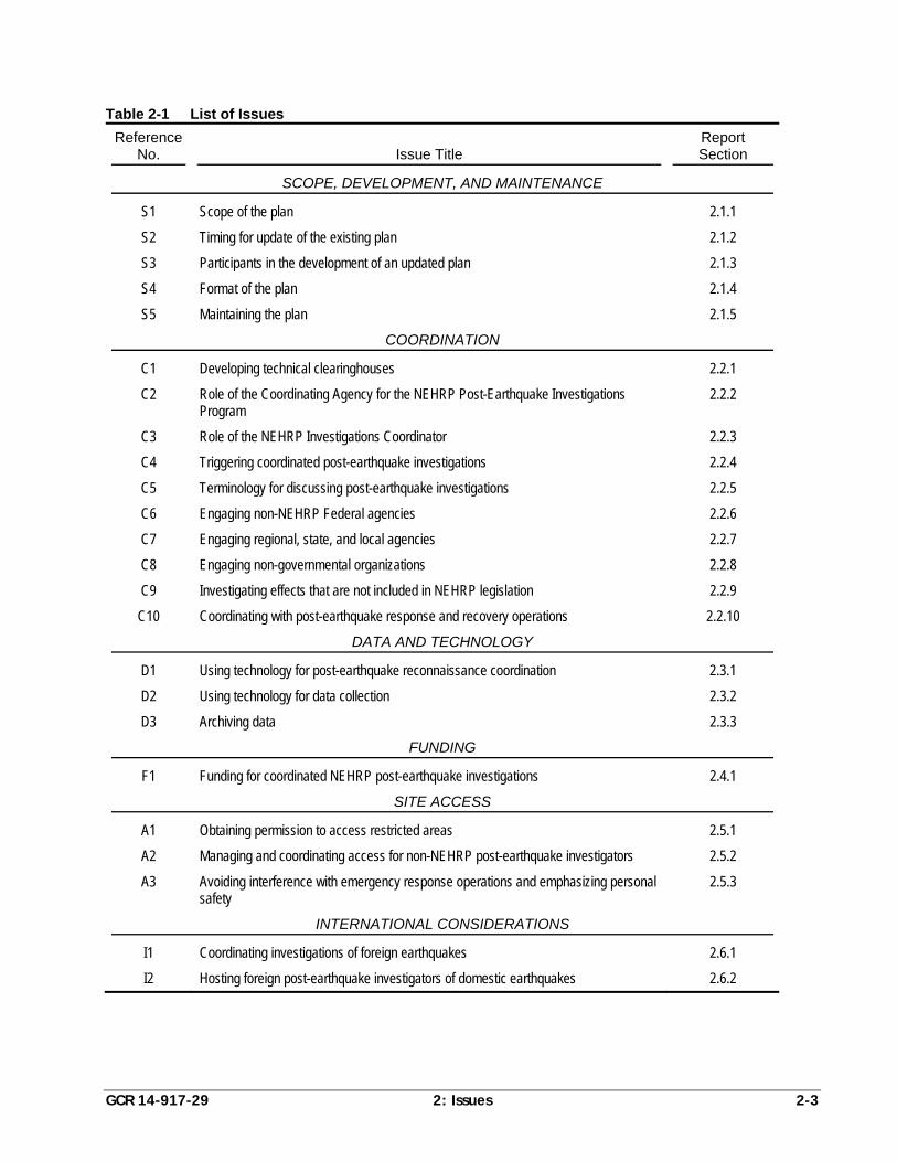
Table 2-1 provides a summary list of issues identified by the project team. Each
issue is discussed in a consistent format that includes: (1) a Question Presented,
which succinctly summarizes the issue; (2) a Background, which discusses the issue
in detail, including a summary of the status quo and challenges associated with
resolving the issue; (3) a list of Alternative Solutions, which presents a range of
possible solutions for how each issue could be resolved; and (4) Recommendations,
which present the recommended approach for resolving each issue along with a brief
explanation of why a particular resolution was chosen.
2.1 Scope, Development, and Maintenance
2.1.1 Issue S1: Scope of the Plan
Question Presented
What should be the scope of the plan in terms of which agencies and organizations
are directed by the plan and what activities are covered by the plan?
Background
A comprehensive plan to coordinate post-earthquake investigations should cover all
aspects of an earthquake and its related physical effects, and should coordinate the
activities of all relevant organizations, to ensure that the investigations are thorough
and that all potential lessons from the event can be extracted. NEHRP post-
earthquake investigations, however, face both legislative and financial restrictions.
Legislatively, NEHRP agencies must fulfill the statutory requirements assigned to
them in the NEHRP legislation (currently Public Law 108-360), and cannot be
directed by another agency to perform tasks that are not assigned by Congress.
USGS Circular 1242 defines the Investigations Coordinator position, which is
charged with leading coordination efforts. USGS Circular 1242 points out that, “it is
impossible to delegate authority to the proposed Investigation Coordinator” to direct
the activities of other NEHRP agencies. Coordination, as defined in USGS Circular
1242, depends on voluntary cooperation among the NEHRP agencies.
Reliance on voluntary cooperation is also true for Federal agencies outside of
NEHRP. There are physical effects associated with earthquakes (e.g., tsunamis and
damage to transportation infrastructure) that are not specifically designated as part of
NEHRP within the legislation. Considering these constraints, it may be unrealistic
GCR 14-917-29 2: Issues 2-3
Table 2-1 List of Issues
Reference No.
Issue Title
Report Section
SCOPE, DEVELOPMENT, AND MAINTENANCE
S1 Scope of the plan 2.1.1
S2 Timing for update of the existing plan 2.1.2
S3 Participants in the development of an updated plan 2.1.3
S4 Format of the plan 2.1.4
S5 Maintaining the plan 2.1.5
COORDINATION
C1 Developing technical clearinghouses 2.2.1
C2 Role of the Coordinating Agency for the NEHRP Post-Earthquake Investigations Program
2.2.2
C3 Role of the NEHRP Investigations Coordinator 2.2.3
C4 Triggering coordinated post-earthquake investigations 2.2.4
C5 Terminology for discussing post-earthquake investigations 2.2.5
C6 Engaging non-NEHRP Federal agencies 2.2.6
C7 Engaging regional, state, and local agencies 2.2.7
C8 Engaging non-governmental organizations 2.2.8
C9 Investigating effects that are not included in NEHRP legislation 2.2.9
C10 Coordinating with post-earthquake response and recovery operations 2.2.10
DATA AND TECHNOLOGY
D1 Using technology for post-earthquake reconnaissance coordination 2.3.1
D2 Using technology for data collection 2.3.2
D3 Archiving data 2.3.3
FUNDING
F1 Funding for coordinated NEHRP post-earthquake investigations 2.4.1
SITE ACCESS
A1 Obtaining permission to access restricted areas 2.5.1
A2 Managing and coordinating access for non-NEHRP post-earthquake investigators 2.5.2
A3 Avoiding interference with emergency response operations and emphasizing personal safety
2.5.3
INTERNATIONAL CONSIDERATIONS
I1 Coordinating investigations of foreign earthquakes 2.6.1
I2 Hosting foreign post-earthquake investigators of domestic earthquakes 2.6.2
2-4 2: Issues GCR 14-917-29
for a plan to assign responsibility to, or to expect long-term cooperation from,
organizations that are outside of the four NEHRP agencies.
Immediately following an earthquake, FEMA, NIST, NSF, and USGS have the
responsibility to determine the level of activity that will be associated with the
Federal response to the earthquake and the scope of the associated investigations.
The NEHRP agencies have limited ability to redirect internal funding to support post-
earthquake activities. For a major earthquake in the United States, supplemental
funding from Congress would be needed to conduct comprehensive post-earthquake
investigations. Without additional funding, it would not be possible for the NEHRP
agencies to perform many of the steps outlined in the current plan.
Appropriate post-earthquake interests and activities for each NEHRP agency must be
deduced from authorized activities delineated in the NEHRP legislation. Based on
information provided by representatives from each agency, roles assigned in USGS
Circular 1242, and recent post-earthquake activities, the current responsibility of each
agency is summarized as follows:
USGS issues information immediately following an earthquake through the
Earthquake Notification Service (ENS), which announces the time, location, and
size of the earthquake, and the Prompt Assessment of Global Earthquakes for
Response (PAGER), which estimates fatalities, economic losses, distribution of
damage, and the likelihood of a tsunami (using data from the National Oceanic
and Atmospheric Administration (NOAA). USGS may also issue aftershock
advisories.
USGS collects, interprets, and maps reports of shaking and other observations by
citizens affected by the earthquake.
USGS hosts a series of coordination phone calls with NEHRP agencies and other
organizations to address a variety of issues related to post-earthquake
investigations, including seismological, engineering, and geological aspects. In
the case of a foreign earthquake, political considerations may also be addressed.
Initial data collection efforts following a domestic earthquake are led by staff at
USGS, NIST, and FEMA. For a foreign earthquake, USGS teams must be
formally invited through the Department of State, and the participation of NIST
and FEMA staff must be justified based on potential relevance to codes and
standards in the United States.
NSF has a long history of funding groups to conduct post-earthquake
investigations, such as the Earthquake Engineering Research Institute (EERI)
Learning from Earthquakes (LFE) program and the Geotechnical Extreme Events
Reconnaissance (GEER) Association. NSF also accepts unsolicited proposals
from individual researchers for Rapid Response Research (RAPID) grants to
GCR 14-917-29 2: Issues 2-5
collect perishable data following a disaster. In the case of extremely damaging
events (e.g., the 2011 earthquakes in New Zealand and Japan, and the 2010
earthquakes in Haiti and Chile), NSF may issue a “Dear Colleague Letter” to
encourage researchers to apply for funding through the RAPID grant program.
Supported with disaster-specific Stafford Act (i.e., non-NEHRP) funding, FEMA
has the option of sending Mitigation Assessment Teams (MATs) into the field to
investigate building performance following a natural disaster. Mitigation
Assessment Teams are used to study damaged and undamaged buildings that
were designed and constructed in accordance with current or recent codes to
determine if the cause of damage was inadequate code provisions, inadequate
construction, or conditions that exceeded code limits. Contractors and paid
subject matter experts, generally accompanied by at least one FEMA
headquarters or regional staff member, serve on teams that are scheduled to
arrive in the field one or two weeks following a disaster to avoid interference
with emergency response activities. MATs have been used in the past to
document damage from domestic hurricanes, floods, and tornadoes, but, to date,
they have not been used following an earthquake. Members of FEMA technical
staff, however, have participated on teams investigating selected foreign
earthquakes (e.g., EERI teams investigating the 1999 Taiwan and 2010 Chile
earthquakes).
In the case of a domestic earthquake, NIST has the option of invoking the
National Construction Safety Team (NCST) Act to study individual building
failures. The Act grants NIST authority for entry and inspection, collection, and
preservation of building components, materials, and artifacts. The NCST Act
states that, in most cases, NCST shall have priority over investigations conducted
by any other Federal agency. The statute also specifies coordination, to the
extent practicable, with qualified researchers who are conducting engineering or
scientific (including social science) research related to the failure of the building.
Therefore, if multiple agencies seek to study a building covered by an NCST
investigation, NIST is required to coordinate as deemed appropriate.
In addition to NEHRP activities, there are non-NEHRP Federal agencies and other
non-governmental organizations that conduct post-earthquake investigations, such as
the Federal Highway Administration (FHWA), the National Tsunami Hazard
Mitigation Program (NTHMP), the Earthquake Engineering Research Institute
(EERI), and the American Society of Civil Engineers (ASCE).
Alternative Solutions
1. The plan could be strictly limited to the four NEHRP agencies and the activities
expressly delineated in the latest NEHRP authorization.
2-6 2: Issues GCR 14-917-29
2. The plan could focus on the four NEHRP agencies but could direct the
Coordinating Agency for the NEHRP Post-Earthquake Investigations Program,
to the extent practicable, to collaborate with other Federal earthquake-related
programs (e.g., NTHMP), other agencies interested in earthquake effects (e.g.,
FHWA), appropriate state agencies, and non-governmental organizations that
have been involved in post-earthquake investigations (e.g., EERI, GEER, and
ASCE).
3. The plan could acknowledge and incorporate all expected post-earthquake
investigation activities by all Federal agencies and non-governmental
organizations. Memoranda of understanding or informal agreements between the
Coordinating Agency for the NEHRP Post-Earthquake Investigations Program
and non-NEHRP entities could be obtained as soon as possible, presumably prior
to any major event.
Recommendations
Alternative Solution 2 is recommended. Although the responsibilities of the NEHRP
agencies and the Coordinating Agency for the NEHRP Post-Earthquake
Investigations Program are limited by legislation, it is recommended that
collaboration and cooperation among all interested parties be encouraged to the
extent practicable. Issues C6, C7, C8, and C9 provide additional more detailed
discussion on this topic.
2.1.2 Issue S2: Timing for Update of the Existing Plan
Question Presented
When should the existing plan be updated?
Background
The current plan, outlined in USGS Circular 1242, was published in 2003 based on
information from a workshop that was held in 2001. Some of the conditions assumed
in the existing plan have changed, technology has advanced significantly, and
coordination among the NEHRP agencies has evolved through other initiatives.
Most agree that the plan needs to be updated; however, conditions that are critical to
formulating an updated plan are currently unknown or inadequately defined. For
example, NEHRP legislation was last reauthorized in 2004, and it is possible that
future legislation could change the Coordinating Agency for the NEHRP Post-
Earthquake Investigations Program (currently USGS), or even the overall Lead
Agency for NEHRP (currently NIST). Post-earthquake reconnaissance efforts
currently funded by NSF through EERI’s Learning from Earthquakes program or
GEER, may or may not be funded in the future. In addition, the George E. Brown, Jr.
Network for Earthquake Engineering Simulation (NEES) could play a significant role
GCR 14-917-29 2: Issues 2-7
in future post-earthquake research and data archiving activities, but the future of this
organization is uncertain at this time.
Alternative Solutions
1. The existing plan could be updated after NEHRP is reauthorized.
2. Ideally, the Lead Agency for NEHRP and the Coordinating Agency for the
NEHRP Post-Earthquake Investigations Program should be identified before the
plan is updated, but if NEHRP is not reauthorized in the near future, the existing
plan could be updated to the extent practicable.
3. The conditions surrounding the coordination of post-earthquake investigations
will never be completely defined, so the existing plan should be updated as soon
as possible.
Recommendations
It is critical to have an up-to-date coordination plan in place because a significant
earthquake could strike at any time. Alternative Solution 3 is recommended, even
though it is acknowledged that an updated plan could be more specific if the details
of new NEHRP authorizing legislation were known. As the current Coordinating
Agency for the NEHRP Post-Earthquake Investigations Program, USGS would be
responsible for launching an update of the existing plan.
2.1.3 Issue S3: Participants in the Development of an Updated Plan
Question Presented
Who should be involved in developing an updated plan?
Background
USGS Circular 1242 was written by a multidisciplinary committee of seven post-
earthquake investigation experts, including five non-governmental participants and
two USGS personnel. The plan was based on input received from a multidisciplinary
workshop attended by government and non-governmental participants. Before it was
finalized, the plan was reviewed by a multi-institutional oversight committee,
including representatives from all NEHRP agencies and other stakeholders.
It is expected that significant involvement of NEHRP agency personnel, and NEHRP
resources, would be needed to update the plan. It is also expected that non-
governmental personnel should be involved. Funded development, and
compensation for non-governmental participants on the update or review committees,
is a model that has been used in the past and could be considered in developing an
updated plan.
2-8 2: Issues GCR 14-917-29
Alternative Solutions
1. The four NEHRP agencies could update the plan under the leadership of the
Coordinating Agency for the NEHRP Post-Earthquake Investigations Program
(USGS) or the NEHRP Lead Agency (NIST), using structures that are already in
place, such as the Advisory Committee on Earthquake Hazards Reduction
(ACEHR).
2. This report was developed by a funded team of experts, including government
and non-governmental participants, under a contract with NIST as the NEHRP
Lead Agency. This effort included provision for input from all four NEHRP
agencies and oversight by an additional group of experts and other stakeholders.
A similar funded development process could be used to update the plan.
3. The plan could be updated by a multidisciplinary committee knowledgeable in
post-earthquake investigations through the conduct of a workshop designed to
obtain input from stakeholders including Federal, state, and local government
representatives, and non-governmental organizations.
Recommendations
Alternative Solution 2 was identified as being the most expedient solution for
updating the existing plan, but there was strong support for the conduct of a
workshop, as outlined in Alternative Solution 3, prior to final update of the plan.
2.1.4 Issue S4: Format of the Plan
Question Presented
What should be the format of an updated plan?
Background
The current plan, as depicted in USGS Circular 1242, is a 20-page document that is
available in hard copy format and on the internet in Portable Document Format
(PDF). The current document includes material about the development process and
recommendations for further action. The recommendations are important, but not
always directly related to coordination activities outlined in the plan.
The following observations were made by the project team and NEHRP agency
representatives regarding the format of the current document and potential future
updated plan documents:
USGS Circular 1242 combines post-earthquake coordination material with other
discussions and recommendations. The additional material distracts from the
material outlining the coordination activities.
GCR 14-917-29 2: Issues 2-9
Regular updating is important, and can be more easily accomplished in an
electronic format without published hard copies. The format could be updated to
function as more of an evolving document in an online environment.
Elements of a plan that depend on technology will require more frequent
updating.
The plan should be coordinated with, or even combined with, plans for other
disaster investigations.
Coordination for post-earthquake investigations should be better aligned with the
day-to-day operations of the NEHRP agencies.
Considering that one NEHRP agency cannot direct the activities of another
agency, and the uncertainty of funding for post-earthquake investigations, the
plan must be acceptable to each agency. The duties of the NEHRP Investigations
Coordinator are important to successfully implementing a plan, but there is no
official authority vested in this position. The plan should be more regularly
updated to account for shifts in agency policies.
NEHRP Agencies should develop standard operating procedures for post-
earthquake investigations.
Alternative Solutions with regard to length and content
1. An updated plan could follow the current format and content of USGS Circular
1242.
2. An updated plan could include only material pertinent to the coordination of
NEHRP agencies. Discussion of the development process, explanatory
commentary, and recommendations for future changes would be excluded.
3. An updated plan could include a description of the development process and
explanatory commentary language provided in appendices.
4. The development process and commentary language could be in a separate
document (i.e., an “update report”) because it is valuable for the record and
important for future updates.
Alternative Solutions with regard to characterization of agency roles and
responsibilities
5. An updated plan could concentrate only on coordination activities, such as the
timeline and responsibilities for organizing coordination phone calls, meetings,
and workshops. The investigative roles, responsibilities, and activities of each
agency could be taken solely from the authorizing NEHRP legislation, with no
additional discussion.
2-10 2: Issues GCR 14-917-29
6. An updated plan could maintain the same tone as USGS Circular 1242 (i.e.,
delineate consensus roles and responsibilities from the authorizing NEHRP
legislation), but indicate that NEHRP agencies must work closely and
cooperatively with other agencies during post-earthquake investigations to take
advantage of all learning opportunities.
7. An updated plan could delineate consensus roles and responsibilities, with the
assumption that issues not dealt with in the plan are the responsibility of the
Coordinating Agency for the NEHRP Post-Earthquake Investigations Program.
Recommendations
There was no support for Alternative Solution 1, which retained the current format of
USGS Circular 1242. Considering length and content, there was strong consensus
for Alternative Solution 4, in which the development process, explanatory
commentary, and recommendations for the future are documented in a separate
report.
Considering the characterization of agency roles and responsibilities, Alternative
Solution 6 was recommended. As discussed in Issues S1, C6, C7, C8, and C9, it is
recognized that although the authority of the Coordinating Agency for the NEHRP
Post-Earthquake Investigations Program is limited, and the roles and responsibilities
of each agency in post-earthquake investigations are defined in authorizing NEHRP
legislation, the plan should encourage cooperation among all interested government
and non-governmental entities on all relevant issues.
2.1.5 Issue S5: Maintaining the Plan
Question Presented
How should a NEHRP post-earthquake coordination plan be maintained (i.e., kept up
to date)?
Background
There is general agreement that the plan for coordinating NEHRP post-earthquake
investigations needs to be updated to consider: changes in agency roles,
responsibilities, and policies; new or changed laws relating to NEHRP; changes in
policies and capabilities of state and local agencies; and increased or decreased
capacity of non-governmental organizations interested in post-earthquake
investigations. To date, there have been no resources available for update of the plan,
other than redirection of existing NEHRP agency personnel and resources.
Changes that might affect the plan do not occur on a regular basis. Periodic updates
that occur on a set schedule may not fully capture these changes unless updates are
scheduled to occur somewhat frequently. More frequent updates might enable the
GCR 14-917-29 2: Issues 2-11
plan to function more effectively at the time of a future earthquake; however, they
would require more resources.
Alternative Solutions
1. The plan could be reviewed and updated every other year.
2. The plan could be reviewed and updated every five years.
3. The plan could be reviewed and updated any time that significant legal and
policy conditions that control the plan change, as judged by an existing body
(e.g., the Advisory Committee on Earthquake Hazards Reduction (ACEHR) or
the Coordinating Agency for the NEHRP Post-Earthquake Investigations
Program), or after every event that triggers the plan.
Recommendations
A combination of Alternative Solutions 2 and 3 is recommended. The plan should be
reviewed and updated by the Coordinating Agency for the NEHRP Post-Earthquake
Investigations Program after every event that triggers the plan, and after significant
changes to legal and policy conditions that control the plan. At a minimum, review
and update should occur every five years. This approach is envisioned as a balance
between the need to keep the plan up to date and the expenditure of resources that
would be necessary to do so.
2.2 Coordination
2.2.1 Issue C1: Developing Technical Clearinghouses
Question Presented
How should the plan incorporate technical clearinghouses to support post-earthquake
investigations?
Background
A technical clearinghouse is defined as the field location in a region affected by an
earthquake where post-earthquake investigators meet to organize and coordinate
activities. Technical clearinghouses are considered to be an integral part of post-
earthquake investigations.
USGS Circular 1242 assigns USGS, FEMA, and EERI with the responsibility of
working with state agencies to organize a technical clearinghouse within 24 hours of
a damaging earthquake in the United States. Working with state and local agencies,
and maintaining direct communications with the Federal Coordinating Officer (FCO)
and the State Coordinating Officer (SCO) for the earthquake (or their respective
designees), is important to ensure that post-earthquake investigation activities do not
interfere with emergency response activities. In addition, opportunities for
2-12 2: Issues GCR 14-917-29
technology transfer are enhanced if state and local agencies are involved from the
beginning.
In some parts of the United States, the epicentral region could be expected to cross
state boundaries, and multi-state consortia (e.g., the Western States Seismic Policy
Council (WSSPC) and the Central United States Earthquake Consortium (CUSEC)),
have addressed coordination issues. The degree of leadership or responsibility
assigned to the NEHRP agencies in establishing a technical clearinghouse will
depend on the extent of planning that has taken place at the state, local, and regional
levels before an event.
USGS Circular 1242 notes that, if a clearinghouse is to be established quickly after
an earthquake, the general operational plans must be prepared in advance. USGS
was assigned responsibility for earth science aspects, and a non-Federal entity, EERI,
was assigned responsibility for engineering and socioeconomic aspects of operating a
clearinghouse. USGS Circular 1242 also recommends that agreements with affiliated
earthquake engineering centers, earth science centers, universities, and professional
groups be established before an earthquake in order to develop comprehensive plans
for post-earthquake investigations.
Funding of clearinghouses is not always available. In cases where a clearinghouse
would have life-saving or life-sustaining benefits to response activities,
clearinghouses have been funded using Stafford Act disaster funds (e.g., 1994
Northridge and 2001 Nisqually earthquakes). In other cases, requests to fund
clearinghouses have been denied.
Alternative Solutions
1. The procedures for establishing field technical clearinghouses could be the same
as those outlined in USGS Circular 1242.
2. The Coordinating Agency for the NEHRP Post-Earthquake Investigations
Program could assume responsibility for developing technical clearinghouses.
3. The Coordinating Agency for the NEHRP Post-Earthquake Investigations
Program could work with state agencies or regional consortia to establish
technical clearinghouses. In the event that planning at the state, local, or regional
levels has not taken place, the Coordinating Agency for the NEHRP Post-
Earthquake Investigations Program could encourage establishment of technical
clearinghouses.
Recommendations
Alternative Solution 3 is recommended. This solution is similar to the current
procedures in USGS Circular 1242, but also leverages the planning activities that
could take place at the state, local, and regional levels.
GCR 14-917-29 2: Issues 2-13
2.2.2 Issue C2: Role of the Coordinating Agency for the NEHRP Post-Earthquake Investigations Program
Question Presented
What should be the responsibilities of the Coordinating Agency for the NEHRP Post-
Earthquake Investigations Program?
Background
NEHRP legislation (Public Law 108-360) assigns USGS as the Coordinating Agency
for the NEHRP Post-Earthquake Investigations Program and defines this role as:
“There is established within the United States Geological Survey a post-
earthquake investigations program, the purpose of which is to investigate major
earthquakes, so as to learn lessons which can be applied to reduce the loss of
lives and property in future earthquakes. The United States Geological Survey,
in consultation with each Program agency, shall organize investigations to study
the implications of the earthquake in the areas of responsibility of each Program
agency. The investigations shall begin as rapidly as possible and may be
conducted by grantees and contractors. The Program agencies shall ensure that
the results of investigations are disseminated widely. The Director of the Survey
is authorized to utilize earthquake expertise from the Agency, the National
Science Foundation, the National Institute of Standards and Technology, other
Federal agencies, and private contractors, on a reimbursable basis, in the conduct
of such earthquake investigations. At a minimum, investigations under this
section shall include:
1. analysis by the National Science Foundation and the United States
Geological Survey of the causes of the earthquake and the nature of the
resulting ground motion;
2. analysis by the National Science Foundation and the National Institute of
Standards and Technology of the behavior of structures and lifelines, both
those that were damaged and those that were undamaged; and
3. analysis by each of the Program agencies of the effectiveness of the
earthquake hazards mitigation programs and actions relating to its area of
responsibility under the Program, and how those programs and actions could
be strengthened.”
At present, House of Representatives Bill 2132 (H.R. 2132, 2013), Natural Hazards
Risk Reduction Act of 2013, has been introduced, but NEHRP legislation has not been
reauthorized. In H.R. 2132, the Lead Agency for NEHRP would also be assigned the
responsibility of organizing post-earthquake investigations. This would transfer the
role of Coordinating Agency for the NEHRP Post-Earthquake Investigations Program
2-14 2: Issues GCR 14-917-29
from USGS to NIST. The role of the Coordinating Agency for the NEHRP Post-
Earthquake Investigations Program is defined more generally in H.R. 2132 than in
the existing NEHRP legislation, as follows:
“The Program shall include a post-earthquake investigations program, the
purpose of which is to investigate major earthquakes so as to learn lessons which
can be applied to reduce the loss of lives and property in future earthquakes. The
lead Program agency, in consultation with each Program agency, shall organize
investigations to study the implications of earthquakes in the areas of
responsibility of each Program agency. The investigations shall begin as rapidly
as possible and may be conducted by grantees and contractors. The Program
agencies will ensure that the results of the investigations are disseminated
widely.”
NEHRP agencies must fulfill the statutory requirements assigned to them in the
authorizing NEHRP legislation, and cannot be directed by another agency to perform
tasks that are not assigned by Congress. Immediate dissemination of scientific
information regarding the location, magnitude, and extent of shaking after an
earthquake is within the statutory responsibilities of USGS. Therefore, it is
anticipated that USGS will be the primary source of technical information in the first
few days after an event. In addition, USGS has strong relationships with state and
local agencies through regional offices and ongoing coordination efforts. This local
presence is extremely important in determining the scope of the damage and the
likely impact of a coordinated post-earthquake investigation.
Although the existing NEHRP legislation and H.R. 2132 do not differentiate between
actions that are taken immediately after an earthquake and those that occur several
years after the event, USGS Circular 1242 defines three phases of activity, and
identifies coordination issues within each phase. Phase I includes activities taken
immediately after an earthquake (within several days of the event). Phase II includes
intensive data gathering and assessment of opportunities for further investigation
based on results of initial reconnaissance efforts (several days to one month after the
event). Phase III represents the period when research activities are underway and the
Coordinating Agency for the NEHRP Post-Earthquake Investigations Program is
responsible for dissemination of information learned from the post-earthquake
investigations (one month to five years after the event).
Activities in Phase II focus on the decision to organize a coordinated NEHRP
response to the earthquake and whether or not supplemental funding should be
requested from Congress. In Phase III, the Coordinating Agency for the NEHRP
Post-Earthquake Investigations Program becomes responsible for organizing
workshops and publishing reports to ensure that the results of the post-earthquake
investigations and lessons learned are widely disseminated. This includes a
GCR 14-917-29 2: Issues 2-15
workshop to discuss priorities for long-term investigations and the publication of a
three-month event summary report.
With a duration of up to five years, Phase III is notably long, although it is likely that
much of the anticipated longer term research following an event might be completed
before five years. NEHRP agency representatives cautioned that, due the different
statutory responsibilities of each agency, oversight of coordination issues in Phase III
may be more difficult than anticipated in USGS Circular 1242.
In the time since USGS Circular 1242 was published, no major domestic earthquake
has occurred, and an opportunity to fully implement the plan has not presented itself.
However, in its current role as the Coordinating Agency for the NEHRP Post-
Earthquake Investigations Program, USGS has organized a series of conference calls
immediately following earthquakes (foreign and domestic) that have occurred over
this time period. These calls have provided an opportunity for NEHRP agencies to
exchange information regarding necessary response activities. Representatives from
other Federal agencies, and from other interested non-governmental agencies and
organizations, have often been included in these calls.
Alternative Solutions
1. The role of the Coordinating Agency for the NEHRP Post-Earthquake
Investigations Program could remain the same as currently described in USGS
Circular 1242.
2. The role of the Coordinating Agency for the NEHRP Post-Earthquake
Investigations Program could be revised to focus on coordination issues during
what is currently defined as Phase I and Phase II after an earthquake. The
duration of Phase II could be extended to include the priority-setting workshop
and the development of a three-month event summary report. At the conclusion
of Phase II, each NEHRP agency would then be responsible for setting its own
agenda for additional investigations, dissemination of information, and archiving
of data. Ongoing coordination issues related to risk mitigation, hazard
assessment, and planning with state, local, and regional organizations would be
explicitly assigned to each NEHRP agency based on statutory responsibilities,
and would not need to be included in the post-earthquake investigation plan.
Recommendations
Alternative Solution 1 is recommended. The role of the Coordinating Agency for the
NEHRP Post-Earthquake Investigations Program, and approach described in USGS
Circular 1242, which includes Phase III, is considered the most appropriate for
maintaining structured, interagency communication, identifying lessons learned, and
ensuring that information is properly disseminated.
2-16 2: Issues GCR 14-917-29
2.2.3 Issue C3: Role of the NEHRP Investigations Coordinator
Question Presented
Should an updated plan include the role of NEHRP Investigations Coordinator, as
envisioned in USGS Circular 1242?
Background
USGS Circular 1242 sets forth the role of NEHRP Investigations Coordinator for
providing oversight of all NEHRP post-earthquake investigation activities. The
Coordinating Agency for the NEHRP Post-Earthquake Investigations Program
(currently USGS) is responsible for naming the NEHRP Investigations Coordinator
within 24 hours of a significant earthquake. This person is to be chosen from a
consensus list agreed upon in advance. USGS Circular 1242 defines the following
responsibilities for the NEHRP Investigations Coordinator:
“(1) to ensure that disaster response activities are not impeded by scientific and
technical investigations; (2) to provide emergency managers with timely and
relevant information about ongoing field investigations; (3) to facilitate
coordination of NEHRP agencies; (4) to ensure that NEHRP press releases are
coordinated and consistent; and (5) to work with scientific and engineering
leaders to identify critical investigations and gaps in the ongoing investigation.”
From an administrative perspective, several concerns were raised about the NEHRP
Investigations Coordinator position. First, any interagency collaboration must be
voluntary because employees from one Federal agency cannot direct employees from
another Federal agency. In recognition of this, it was envisioned that the position
would be filled by an individual who was well-respected and well-connected within
the NEHRP agencies. Second, a person serving as the point of contact for emergency
managers and local officials is likely to need strong ties to the state and local
communities in the epicentral region. A person with the necessary local connections
may not have the Federal contacts necessary to optimize deployment of NEHRP
resources and set priorities for NEHRP post-earthquake investigations.
USGS and FEMA have regional offices in which staff have developed strong
relationships with state and local officials who will be leading emergency response
efforts. FEMA regional staff also work closely with the Federal Coordinating Officer
and the State Coordinating Officer, which are appointed in the event of a disaster
declaration.
Alternative Solutions
1. An updated plan could have a NEHRP Investigations Coordinator, as envisioned
in USGS Circular 1242.
GCR 14-917-29 2: Issues 2-17
2. Although the level of coordination envisioned in USGS Circular 1242 offers a
number of advantages for post-earthquake investigations, it is unlikely that a
single person could achieve all the goals envisioned for the NEHRP
Investigations Coordinator. An updated plan should recognize the fact that the
individual with the operational and technical skills needed to coordinate activities
immediately after an event may not also have the administrative skills necessary
to coordinate later phases of the plan among the NEHRP agencies. Therefore,
the responsibilities could be divided among multiple people within the
Coordinating Agency for the NEHRP Post-Earthquake Investigations Program.
3. Recognizing that one person is not likely to have the skills necessary to
coordinate the operational and administrative responsibilities assigned to the
NEHRP Investigations Coordinator in USGS Circular 1242, other options for
assigning these responsibilities should be considered. Although the coordinator
for the administrative and policy issues must be a Federal employee working for
the Coordinating Agency for the NEHRP Post-Earthquake Investigations
Program, the coordinator for the operational and technical issues could possibly
be a contractor located in the epicentral region. Ideally, the coordinator for
operational issues would have established ties with state and local emergency
management personnel. The coordinator for operational and technical issues
would be selected from a preapproved list by the Coordinating Agency for the
NEHRP Post-Earthquake Investigations Program immediately following the
earthquake.
Recommendations
If USGS remains the Coordinating Agency for the NEHRP Post-Earthquake
Investigations Program, then Alternative Solution 2 is recommended. Under this
solution, the NEHRP Investigations Coordinator is likely to have the administrative
skills necessary to engage the NEHRP Agencies. If NIST is assigned the
responsibilities for the Coordinating Agency for the NEHRP Post-Earthquake
Investigations Program, then Alternative Solution 3 is recommended. This solution
provides the flexibility to select a person who is well-suited to meet the operational
and technical needs for coordinating with state and local officials immediately after
an earthquake, while retaining the administrative and policy coordination
responsibilities within NIST.
2.2.4 Issue C4: Triggering Coordinated Post-Earthquake Investigations
Question Presented
What decision criteria should be used to trigger a coordinated NEHRP post-
earthquake investigation?
2-18 2: Issues GCR 14-917-29
Background
In USGS Circular 1242, significant domestic and foreign earthquakes are subject to
coordinated investigation. For domestic earthquakes, the plan is triggered if: (1)
there is a Presidential disaster declaration; or (2) the NEHRP agencies determine that
an earthquake provides an opportunity to learn how to reduce future earthquake
losses in the United States. For foreign earthquakes, the criteria are not as clearly
defined. Teams must be formally invited by the impacted country through the
Department of State, and participation by NIST and FEMA must be justified based
on potential relevance to U.S. codes and standards. USGS Circular 1242 highlights
the role for international coordination that has been performed by EERI through its
Learning from Earthquakes program. USGS Circular 1242 also notes that
uncoordinated deployment of U.S. investigators to foreign earthquakes has drawn
complaints from affected countries to the Department of State. Optional aspects for
triggering the plan include events of sufficient scale to justify supplemental funding.
NIST has developed a comprehensive set of decision criteria that are used to
determine if a National Construction Safety Team investigation is justified. These
criteria include: (1) extent of loss of life; (2) exposed population; (3) magnitude of
the hazard; (4) scale of the damage (in terms of consequences to resilience); (5)
evacuation and emergency response; and (6) codes, standards, and enforcement (for
international events). Six additional questions addressing general principles are also
provided to help guide a decision: (1) whether new knowledge can be gained from
the study; (2) anticipated impact on standards, codes, and practices; (3) available
resources (in terms of people and funding); (4) safety of the site; (5) stakeholder
concerns; and (6) whether NIST has primary authority or unique expertise.
Since the development of USGS Circular 1242, USGS has significantly refined its
tools for information dissemination immediately following an earthquake. PAGER is
an automated system that estimates the impact of an earthquake in terms of economic
loss and the number of fatalities. This information has proven to be extremely
important for determining the scope of post-earthquake investigations for large
earthquakes in foreign countries in recent years. Data from PAGER are reviewed
during the coordination calls immediately after an earthquake, and the research
potential is discussed by NEHRP agency personnel.
One of the complicating factors for coordinated investigations of foreign earthquakes
is that NIST and FEMA must demonstrate that the information obtained from post-
earthquake investigations will be directly relevant to codes and standards in the
United States. This criterion for participation can be difficult to achieve, especially
in developing countries where construction practices are frequently not representative
of those in the United States. USGS and NSF, however, often fund researchers to
GCR 14-917-29 2: Issues 2-19
collect perishable data following foreign earthquakes, provided that the research
results are likely to influence practice in the United States.
Although the plan has not been triggered since USGS Circular 1242 was published,
NEHRP agency staff have collaborated immediately following earthquakes, through
conference calls hosted by USGS, to determine the appropriate level of NEHRP
response. These activities, in effect, could be considered a lower threshold of
coordination among NEHRP agencies that does not trigger full-scale implementation
of the plan.
Alternative Solutions for Domestic Earthquakes
1. For domestic earthquakes, the current triggers listed in USGS Circular 1242
could be retained.
2. A more detailed set of criteria could be developed for determining if coordinated
post-earthquake investigations are warranted for domestic earthquakes.
Alternative Solutions for Foreign Earthquakes
3. For foreign earthquakes, each earthquake could be evaluated independently, and
the plan could be triggered if more than one agency believes that the earthquake
provides an opportunity to learn how to reduce future earthquake losses in the
United States.
4. The Coordinating Agency for the NEHRP Post-Earthquake Investigations
Program could develop a list of countries in which the seismological or
geological settings, the level of codes and construction practices, and the
emergency response capabilities are such that post-earthquake investigations are
likely to have a direct impact on design and construction practices in the United
States. This list could be used to determine when to activate the plan.
5. Post-earthquake investigations of foreign earthquakes could be limited to
situations in which the affected country has requested assistance from the United
States.
Recommendations
For response to domestic earthquakes, Alternative Solution 1 is recommended
because the current triggers seem to be adequate.
For response to foreign earthquakes, Alternative Solution 3 is recommended. USGS
and NSF have a long history of supporting post-earthquake investigations of foreign
earthquakes, but a new criterion for participation of NIST and FEMA is needed. A
significant issue could arise if future legislation assigns NIST as the Coordinating
Agency for the NEHRP Post-Earthquake Investigations Program, but NIST is not
allowed to participate in post-earthquake investigations of a foreign earthquake. The
2-20 2: Issues GCR 14-917-29
participation of two NEHRP agencies should be sufficient to justify triggering the
full plan for coordinated NEHRP post-earthquake investigations.
2.2.5 Issue C5: Terminology for Discussing Post-Earthquake Investigations
Question Presented
How should an updated plan address the varying terminology used by different
NEHRP agencies to improve coordination?
Background
In discussions among NEHRP agency representatives, it was noted that different
agencies and disciplines use different terminologies when discussing earthquake
reconnaissance and related data. This can lead to misunderstandings that may
impede coordination. In addition to conducting earthquake reconnaissance, some
agencies record and archive data. Having a clear understanding of regularly used
terminology would help in sharing these data.
One such example is the term research. Some agencies perceive this term to refer to
the activities of data collection and interpretation that occur within a short period
following an earthquake. Other agencies perceive this term to refer to longer-term
studies, perhaps supported with special funds triggered by the event, which begin
months after the event and can extend for years. Some agencies do not have research
included as part of their mandate and, therefore, do not use the term. Such agencies
might support technical studies, but these studies, by some interpretations, might be
considered similar to research.
There is also terminology associated with specific programs operated by each agency
following an earthquake or other disaster. Examples include the Hazards Data
Distribution System at USGS, the Mitigation Assessment Team program at FEMA,
the National Construction Safety Team Act at NIST, and grants for Rapid Response
Research at NSF. Additionally, the post-earthquake coordination plan, itself, might
define specific activities, roles, or responsibilities associated with coordination after
an event. Having a clear definition and understanding of the various programs,
activities, roles, and responsibilities is necessary to facilitate coordination.
In evaluating this issue, an effort was undertaken to identify key terminology
associated with post-earthquake activities that are possible sources of
misunderstanding and important for coordinating response. Appendix B presents a
list of selected terminology along with definitions taken from a variety of sources.
This list is intended to serve as background and a starting point for future
development of a set of standard nomenclature. It is not intended to set definitions
for standard nomenclature at this time.
GCR 14-917-29 2: Issues 2-21
Alternative Solutions
1. An updated plan could be developed without a standard nomenclature. NEHRP
agency programs and terminology in different disciplines are moving targets for
which a standard nomenclature could become out of date, potentially leading to
more confusion than already exists.
2. An updated plan could clearly define the terms that are potentially misleading in
post-earthquake coordination planning to avoid confusion, but could stop short of
attempting to develop a standard nomenclature.
3. An updated plan could define a standard nomenclature for all terms deemed
critical for coordination.
4. An updated plan could define standard nomenclature in an online entity (e.g., a
wiki) to more readily allow for update as terminology and programs evolve.
Recommendations
Alternative Solution 3 is recommended. A standard nomenclature for terms that are
critical for coordination should be developed and included in an updated post-
earthquake coordination plan. Alternative Solution 4 should be considered as an
additional activity, developing a standard nomenclature as an evolving electronic
resource.
2.2.6 Issue C6: Engaging Non-NEHRP Federal Agencies
Question Presented
How should an updated plan engage non-NEHRP Federal agencies?
Background
Several non-NEHRP Federal agencies conduct earthquake-related programs, and
some actively support post-earthquake reconnaissance. These agencies include: the
Department of Defense (DOD) along with the U.S. Army Corps of Engineers
(USACE), the Department of Energy (DOE), the Federal Highway Administration
(FHWA), the National Aeronautics and Space Administration (NASA), the National
Oceanic and Atmospheric Administration (NOAA), and the U.S. Nuclear Regulatory
Commission (USNRC). Coordination among these agencies could facilitate post-
earthquake reconnaissance activities for all the involved agencies.
For example, none of the four NEHRP agencies has a mandate to carry out activities
related to highway infrastructure. FHWA, a non-NEHRP Federal agency, regularly
supports research and development activities related to seismic design of highway
infrastructure. FHWA also commonly conducts post-earthquake reconnaissance
focused on highway infrastructure. Undoubtedly, coordination among the NEHRP
agencies and FHWA would broaden post-earthquake learning opportunities.
2-22 2: Issues GCR 14-917-29
Another example is NOAA, which is a member of the International Charter for Space
and Major Disasters (www.disasterscharter.org) that aims to provide a unified system
of space data acquisition and delivery to those affected by natural or man-made
disasters. After an earthquake, NOAA coordinates with USGS in providing data.
Although NEHRP agencies are not authorized to coordinate the activities of these
other Federal agencies, voluntary cooperation among agencies could facilitate access
and data collection associated with post-earthquake investigations. It should be noted
however, that in the authorizing legislation, NEHRP activities are limited to certain
specific aspects of earthquakes and their related physical effects, so coordination with
other Federal agencies should emphasize coordination on the physical effects of
earthquakes that are included in the NEHRP authorization.
Alternative Solutions
1. The Coordinating Agency for the NEHRP Post-Earthquake Investigations
Program could postpone coordination efforts with non-NEHRP Federal agencies
until after an event occurs, allowing the coordination effort to take place once the
nature of the event and the coordination needs are more clear.
2. The Coordinating Agency for the NEHRP Post-Earthquake Investigations
Program could commit to engaging appropriate organizations in post-event
coordination calls. The actual level of coordination would depend on the scope
of the disaster, but contacts would be established in advance of an earthquake.
3. The Coordinating Agency for the NEHRP Post-Earthquake Investigations
Program, along with its appropriate NEHRP agency partners, could meet with
non-NEHRP Federal agencies and discuss potential participation and
coordination of post-earthquake investigations in advance of an earthquake.
4. In addition to meetings conducted under Alternative Solution 3, the Coordinating
Agency for the NEHRP Post-Earthquake Investigations Program, along with its
appropriate NEHRP agency partners, could identify non-NEHRP Federal
agencies for which coordination almost certainly would be required for domestic
earthquakes, and develop, where appropriate, memoranda of understanding or
other cooperative agreements with those organizations in advance of an
earthquake.
5. The Coordinating Agency for the NEHRP Post-Earthquake Investigations
Program could identify non-NEHRP Federal agencies that may have interests in
earthquake-related activities, or who may facilitate access to sites or data, and
conduct a workshop to identify optimal approaches for achieving pre-event
agreement for post-event cooperation. This effort could be followed with the
development of memoranda of understanding or other arrangements, where
appropriate, in advance of an earthquake.
GCR 14-917-29 2: Issues 2-23
Recommendations
Alternative Solutions 2, 3, and 4 are recommended. In its current role as the
Coordinating Agency for the NEHRP Post-Earthquake Investigations Program,
USGS has engaged appropriate non-NEHRP Federal agencies in conference calls
immediately following foreign and domestic earthquakes that have occurred, and
maintained a contact list. These efforts should continue.
To the degree possible, the Coordinating Agency for the NEHRP Post-Earthquake
Investigations Program should consider meeting with non-NEHRP Federal agencies
that will potentially participate in post-earthquake investigations to discuss avenues
for coordination. Where appropriate and necessary to accomplish the NEHRP
authorization mandates, memoranda of understanding or other cooperative
agreements should be pursued between agencies. After an event, if other
organizations are identified for which coordination would be beneficial, coordination
should be pursued with those organizations.
Because NEHRP agencies do not have the authority to direct any agency outside of
NEHRP, an updated plan should not assign any essential post-earthquake activities to
non-NEHRP Federal agencies.
2.2.7 Issue C7: Engaging Regional, State, and Local Agencies
Question Presented
How should an updated plan engage regional, state, and local agencies?
Background
Many state and local organizations have programs that relate to post-earthquake
reconnaissance and investigation. For example, some state transportation
departments conduct earthquake reconnaissance as part of their maintenance and
learning activities, and some cities have building inspection programs that could
contribute to data collection. Such activities should be considered in the overall plan
for NEHRP post-earthquake investigations.
In addition, some states and multi-state regions have well-developed post-earthquake
clearinghouse organizations, and others are developing plans for them. Examples
include the California Earthquake Clearinghouse and Central United States
Earthquake Consortium (CUSEC). Following the 1994 Northridge and 2001
Nisqually earthquakes, clearinghouses were particularly effective in coordinating
post-earthquake reconnaissance activities. It is anticipated that clearinghouses will
continue to be central to reconnaissance activities in California, the Pacific
Northwest, Utah, and other regions of the United States. Whether future
clearinghouse activities need to be centrally located, distributed, or virtual will
depend on the extent of the earthquake effects and the technological capabilities
2-24 2: Issues GCR 14-917-29
adopted by the various entities. Post-earthquake reconnaissance activities of NEHRP
agencies are likely to be closely linked to regional clearinghouse activities.
Alternative Solutions
1. The Coordinating Agency for the NEHRP Post-Earthquake Investigations
Program could postpone coordination efforts with regional, state, and local
agencies until after an event occurs, allowing the coordination effort to take place
after the nature of the event and the coordination needs are more clear.
2. The Coordinating Agency for the NEHRP Post-Earthquake Investigations
Program could commit to engaging appropriate regional, state, and local agencies
in post-event coordination calls. The actual level of coordination would depend
on the scope of the disaster, but contacts would be established in advance of an
earthquake.
3. The Coordinating Agency for the NEHRP Post-Earthquake Investigations
Program, along with appropriate NEHRP agency partners, could meet with
regional, state, and local agencies that will potentially participate in post-
earthquake investigations to discuss potential participation and coordination in
advance of an earthquake.
4. In addition to meetings conducted under Alternative Solution 3, the Coordinating
Agency for the NEHRP Post-Earthquake Investigations Program could develop
memoranda of understanding or other cooperative agreements with appropriate
regional, state, and local agencies, in advance of an earthquake.
5. The Coordinating Agency for the NEHRP Post-Earthquake Investigations
Program could identify appropriate state and regional agencies (and key local
agencies) and conduct a workshop to identify optimal approaches for achieving
pre-event agreement for post-event cooperation. This effort could be followed
with the development of memoranda of understanding or other cooperative
agreements, where appropriate, in advance of an earthquake.
Recommendations
Alternative Solutions 2, 3, and 4 are all recommended. Regional, state, and local
earthquake response and reconnaissance activities should be considered in the plan
for coordination of NEHRP post-earthquake investigations following domestic
earthquakes. The Coordinating Agency for the NEHRP Post-Earthquake
Investigations Program should, as a minimum, make a commitment to engage
appropriate regional, state, and local agencies in post-event coordination calls, and
should maintain a contact list. Meetings with agencies that will potentially
participate in post-earthquake investigations should be held to discuss avenues for
possible coordination. Where appropriate, where necessary to accomplish the
NEHRP authorization mandates, or where otherwise beneficial, memoranda of
GCR 14-917-29 2: Issues 2-25
understanding or other cooperative agreements should be pursued between individual
NEHRP agencies and state or regional agencies. After an event, if other state or
regional agencies are identified for which coordination would be beneficial,
coordination should be pursued. FEMA has ongoing relationships with many state
and regional agencies. These existing relationships should be leveraged in planning
for post-earthquake investigations.
Because NEHRP agencies do not have the authority to direct the activities of
regional, state, or local agencies, an updated plan should not assign any essential
post-earthquake activities to such agencies.
2.2.8 Issue C8: Engaging Non-Governmental Organizations
Question Presented
How should an updated plan engage non-governmental organizations?
Background
There are numerous non-governmental organizations that have interest in earthquakes
and active programs in post-earthquake reconnaissance and data collection. These
include the American Concrete Institute (ACI), ASCE, EERI, GEER, the Natural
Hazards Center, the Pacific Earthquake Engineering Research Center (PEER), the
Southern California Earthquake Center (SCEC), and the Technical Council on
Lifeline Earthquake Engineering (TCLEE).
Some of these organizations have interests in specific materials (e.g., ACI is
interested in concrete-related construction), in building codes (e.g., ASCE), or in
specific disciplines (e.g., GEER for geotechnical effects, SCEC for earthquake
mechanisms and ground motions, and the Natural Hazards Center for hazards
mitigation and disaster preparedness, response, and recovery). Other organizations
have a broader mission in earthquake engineering (e.g., EERI approaches
investigations primarily from a professional practice perspective, and PEER
approaches investigations primarily from a research perspective).
A number of non-governmental organizations have long histories of earthquake
reconnaissance following both domestic and foreign earthquakes. Currently, USGS
Circular 1242 defines a number of roles for EERI, which is a non-governmental
organization that has coordinated many multidisciplinary reconnaissance teams. It
should be noted that some organizations receive funding in whole, or in part, from
NEHRP agencies, while others receive no funding, and the level of support provided
to non-governmental organizations in post-earthquake investigations has been
evolving over time. Coordination with non-governmental organizations could
facilitate post-earthquake investigations for all, and improve overall learning from
earthquakes.
2-26 2: Issues GCR 14-917-29
Alternative Solutions
1. The Coordinating Agency for the NEHRP Post-Earthquake Investigations
Program could postpone coordination efforts with non-governmental
organizations until after an event occurs, allowing the coordination effort to take
place after the nature of the event and the coordination needs are more clear.
2. The Coordinating Agency for the NEHRP Post-Earthquake Investigations
Program could commit to engaging appropriate non-governmental organizations
in post-event coordination calls. The actual level of coordination would depend
on the scope of the disaster, but contacts would be established in advance of an
earthquake.
3. The Coordinating Agency for the NEHRP Post-Earthquake Investigations
Program, along with its appropriate NEHRP agency partners, could identify
appropriate non-governmental organizations and develop memoranda of
understanding or other cooperative agreements in advance of an earthquake.
4. The Coordinating Agency for the NEHRP Post-Earthquake Investigations
Program could identify leading non-governmental organizations and conduct a
workshop to identify optimal approaches for achieving pre-event agreement for
post-event cooperation. This effort could be followed with the development of
memoranda of understanding or other cooperative agreements, where
appropriate, in advance of an earthquake.
Recommendations
Alternative Solutions 2 and 3 are recommended. The Coordinating Agency for the
NEHRP Post-Earthquake Investigations Program should, as a minimum, make a
commitment to engage appropriate non-governmental organizations in post-event
coordination calls, and should maintain a contact list. Discussions with organizations
that will potentially participate in post-earthquake investigations should be held to
determine possible avenues for coordination. Where appropriate, where necessary to
accomplish the NEHRP authorization mandates, or where otherwise beneficial,
memoranda of understanding or other cooperative agreements should be pursued
between individual NEHRP agencies and non-governmental organizations. After an
event, if other non-governmental organizations are identified for which coordination
would be beneficial, coordination should be pursued.
Because NEHRP agencies do not have the authority to direct the activities of non-
governmental organizations, an updated plan should not assign any essential post-
earthquake activities to non-governmental organizations. Furthermore, NEHRP
agencies should not assume that historical activities of non-governmental
organizations will continue in the future.
GCR 14-917-29 2: Issues 2-27
2.2.9 Issue C9: Investigating Effects that are not included in NEHRP Legislation
Question Presented
How should an updated plan address the investigation of important earthquake-
related effects and damage to infrastructure that are not included in the authorizing
NEHRP legislation?
Background
Earthquakes affect all aspects of the built environment, can result in additional
physical effects beyond earthquake shaking (e.g., liquefaction, landslides,
subsidence, and tsunamis), and can generate secondary hazards (e.g., fire, chemical
release, and flooding). NEHRP, however, does not cover all earthquake-related
phenomena or damage to all types of structures, and there are non-NEHRP agencies
and organizations that focus on these other hazards and effects. It could be beneficial
to integrate all government responses to an earthquake and related physical effects,
but this must be done within current statutory requirements.
As an example, the effects of tsunamis generated by earthquakes are carefully
documented by the tsunami research community, but funding is not provided through
NEHRP. The National Tsunami Hazard Mitigation Program (NTHMP) was first
formed by Congressional action in 1995 and strengthened by the Tsunami Warning
and Education Act of 2006. The program is a partnership among NOAA, USGS,
FEMA, NSF, and 28 U.S. coastal states, territories, and commonwealths. The
Tsunami Warning and Education Act of 2006 also assigns NOAA, through the
National Weather Service (NWS), the responsibility to provide tsunami alerts and
notifications for tsunamis generated anywhere in the world that might impact U.S.
states and territories. The NTHMP is a major source of Federal support for the
tsunami warning system, the state tsunami programs, and the TsunamiReady
program, which promotes community preparedness for tsunamis, and hazard
assessment, mitigation, and readiness activities. The NTHMP also sets the standards
for tsunami source identification, numerical modeling, and inundation and hazard
mapping. Unless the Tsunami Warning and Education Act of 2006 is reauthorized,
the future of the TsunamiReady program and state leadership for local tsunami
hazard assessment, mitigation and preparedness will be at significant risk.
Other secondary hazards, such as fire following an earthquake, chemical release,
flooding from dam or levee failure, or nuclear radiation, are important to post-
earthquake investigations, but also are not specifically covered under the NEHRP
legislation. USGS Circular 1242 does not mention investigation of these secondary
hazards. Most, if not all, are already under the responsibility of Federal agencies,
often not directly related to earthquake causation. However, certain NEHRP
agencies, or the Coordinating Agency for the NEHRP Post-Earthquake
2-28 2: Issues GCR 14-917-29
Investigations, may be involved in activities that cross over from NEHRP issues into
these areas. Access to areas affected by some of these secondary hazards requires
high-level expertise and training (e.g., fire, chemical release, and radiation), so it is
prudent to restrict these activities to designated Federal agencies, who could then
share data at a later date.
In addition to building structures, transportation systems and other infrastructure may
be significantly affected by earthquakes. These systems are not included in NEHRP,
but other agencies, such as FHWA and state transportation organizations (for
transportation infrastructure), and U.S. Army Corps of Engineers (for dams or
levees), frequently send out reconnaissance teams to collect important data.
At this time, the authorizing NEHRP legislation does not include tsunami effects,
damage to transportation infrastructure, and other important earthquake hazards and
effects, including chemical release, flooding, and nuclear radiation. NEHRP
agencies cannot address issues outside of their authorization, which makes it
challenging to provide a coordinated effort that addresses all important earthquake
hazards and effects. At present, government agencies collaborate informally and
share data after earthquakes, as is currently done by USGS and NOAA. NOAA uses
data from USGS to issue tsunami warnings, and USGS includes links to the NOAA
website on their event webpages.
Alternative Solutions
1. An updated plan could be strictly limited to the scope of the four NEHRP
agencies, as defined in the latest reauthorization. Thus, it would not consider
impacts from tsunamis, damage to transportation infrastructure, and other issues
excluded from NEHRP authorization.
2. An updated plan could focus on the scope of the four NEHRP agencies, as
defined in the latest reauthorization, but could direct the Coordinating Agency for
the NEHRP Post-Earthquake Investigations Program, to the extent practicable, to
prepare for collaboration with other Federal agencies, earthquake-related
programs, and non-governmental organizations that will be involved in
investigating non-NEHRP earthquake hazards and effects.
3. An updated plan could explicitly acknowledge important secondary hazards and
earthquake effects, and coordinate the activities of other Federal agencies,
earthquake-related programs, and non-governmental organizations that will be
investigating these effects. This would involve the development of memoranda
of understanding or other cooperative agreements to facilitate post-earthquake
coordination in advance of an earthquake.
GCR 14-917-29 2: Issues 2-29
Recommendations
Alternative Solution 2 is recommended. NEHRP agencies are limited by law from
coordinating post-earthquake investigations in areas outside of their authorization.
However, in the case of some earthquakes, secondary hazards and other earthquake-
related effects can become extremely important, and the Coordinating Agency for the
NEHRP Post-Earthquake Investigations Program should be prepared to coordinate
with relevant agencies when warranted, and when resources are sufficient.
2.2.10 Issue C10: Coordinating with Post-Earthquake Response and Recovery Operations
Question Presented
Should an updated plan acknowledge coordination with agencies defined in the
National Response Framework and the National Disaster Recovery Framework, and
can NEHRP post-earthquake investigations inform post-earthquake response and
recovery?
Background
As described in USGS Circular 1242, a key purpose of coordinating post-earthquake
investigations is to enable NEHRP to be in a stronger position to provide input, and
to work more effectively, with officials involved in post-earthquake emergency
response activities. However, USGS Circular 1242 primarily emphasizes
information gathering and documentation, and does not address Federal response and
planning (primarily because the two main frameworks for disaster response and
recovery did not exist when it was developed). The National Response Framework
(DHS, 2013) was first developed in 2008, and updated May 2013, and the National
Disaster Recovery Framework (FEMA, 2011) was developed in 2011. These are two
of five National Planning Frameworks that help fulfill Presidential Policy
Directive/PPD-8: National Preparedness (PPD-8, 2011) calling on Federal agencies
to work with the whole community in developing a national preparedness goal and a
series of frameworks and plans related to reaching the goal.
The National Response Framework is a guide on how the nation responds to all types
of disasters and emergencies. It is built on scalable, flexible, and adaptable concepts
identified in the National Incident Management System (NIMS), which is based on
the Incident Command System (ICS), to align key managing roles, responsibilities,
and coordinating structures across multiple levels of government and with other
partner organizations. The framework focuses on immediate response in the initial
recovery period following an incident. Fifteen Federal emergency support functions
(ESFs) comprise the primary, but not exclusive, coordinating structure for building,
sustaining, and delivering the capabilities of Federal departments and other national-
level assets (DHS, 2013). Each emergency support function has a designated Federal
2-30 2: Issues GCR 14-917-29
agency as the ESF Coordinator along with a number of primary and support agencies.
Federal agencies supporting emergency support functions may be selectively
activated by FEMA, or directed by the Secretary of Homeland Security, to support
response activities. FEMA may also assign Federal agencies to obtain specific
response resources and services.
The National Disaster Recovery Framework is a guide that enables effective recovery
support to disaster-impacted states, tribes, territories, and local jurisdictions. It also
defines a coordinating structure that can be activated and scaled as appropriate,
depending upon the size and nature of the disaster. The coordinating structure
centers around several key positions, including Federal, State, and Tribal Disaster
Recovery Coordinators (FDRC, SDRC, and TDRC, respectively) and Local Disaster
Recovery Managers (LDRMs), as well as six recovery support functions (RSFs).
FEMA is designated as the lead Federal agency to facilitate and coordinate recovery
support function activities and recovery planning at the national level, and a Federal
agency is designated as the RSF Coordinator along with a number of primary
agencies and supporting organizations. The timeframe of the National Disaster
Recovery Framework can extend for months, even years, following a major disaster.
Input from NEHRP agency representatives suggests that an updated plan for
coordinating post-earthquake investigations should be more clearly linked with the
National Response Framework and National Disaster Recovery Framework activities
to enhance support and potential funding for NEHRP post-earthquake investigation
activities. An updated plan, interagency coordination, communication, data sharing,
and investigation products also need to be consistent and interchangeable with
National Incident Management System practices, such as the Unified Incident
Command and Decision Support (UICDS), which provides information sharing
middleware that continuously receives and shares standardized data among many
agencies during an incident (http://www.uicds.us/). Furthermore, NEHRP post-
earthquake investigation products and insights could be a potential resource available
to National Response Framework and National Disaster Recovery Framework
activities and other post-earthquake response and recovery operations. Thus, there is
a real opportunity for benefiting both the NEHRP investigations and response and
recovery operations.
Because NEHRP is not an agency in and of itself, and funds cannot be transferred to
it, NEHRP would not be directly tasked to perform this work. However, individual
NEHRP agencies perform response and recovery related activities under their own
authority and funding, or through reciprocal mutual assistance and reimbursement
agreements, and do not require a Presidential declaration to do so. Also, with respect
to the National Response Framework and National Disaster Recovery Framework,
individual NEHRP agencies have specifically defined roles, and can also be
individually tasked to perform required response and recovery functions.
GCR 14-917-29 2: Issues 2-31
For example, the National Response Framework states that any Federal agency
responding to an incident may also request support from the Secretary of Homeland
Security in obtaining and coordinating additional Federal assistance. The Secretary
of Homeland Security may activate one or more emergency support functions to
provide the requested support (DHS, 2013). However, it will be difficult to task non-
Federal partner organizations with key roles in an updated NEHRP post-earthquake
coordination plan, and this problem is likely to persist regardless of linkages made to
the National Response Framework and National Disaster Recovery Framework.
Alternative Solutions
1. Response and recovery operations are beyond the scope of a NEHRP
coordination effort. Therefore, an updated plan could ignore consideration of
issues associated with response and recovery.
2. Each NEHRP agency has specific roles and functions that are defined by agency
standard operating procedures, and the current definition of NEHRP agency post-
earthquake coordination activities contained in USGS Circular 1242 could be
deemed adequate.
3. An updated plan could reflect the coordinating structures established by the
National Planning Framework, including the National Response Framework, the
National Disaster Recovery Framework, and supporting annexes. It could clarify
how NEHRP interagency coordination, communication, data sharing, site access,
logistics, and safety fit within these coordinating structures. It could also better
indicate how NEHRP post-earthquake investigations, and the real time, on-site
information they can provide, could be a resource for emergency support
functions and recovery support functions in the National Planning Framework,
and other post-earthquake response and recovery operations. In order to be
effective, the Coordinating Agency for the NEHRP Post-Earthquake
Investigations Program could work in advance of an earthquake to develop
alliances with other Federal agencies in accordance with the responsibilities
assigned to them in the National Response Framework and the National Disaster
Recovery Framework, and then work to facilitate voluntary coordination
following a major earthquake.
4. Response and recovery roles and products for NEHRP post-earthquake
investigations could be detailed in an appendix to an updated plan. Roles and
products could be aligned with the emergency support functions and recovery
support functions and coordinating structure established by the National Planning
Framework, including the National Response Framework, the National Disaster
Recovery Framework, and supporting annexes. The appendix would need to be
periodically reviewed to ensure consistency with the National Planning
Framework as it evolves.
2-32 2: Issues GCR 14-917-29
Recommendations
Alternative Solution 3 is recommended so that the plan reflects the coordinating
structures established by the National Planning Framework, including the National
Response Framework, the National Disaster Recovery Framework, and supporting
annexes, and better indicates how NEHRP post-earthquake investigations fit within,
and support, response and recovery plans, incident management systems and
practices, and coordinating structures.
2.3 Data and Technology
2.3.1 Issue D1: Using Technology for Post-Earthquake Reconnaissance Coordination
Question Presented
How should information technology be used to coordinate post-earthquake
reconnaissance activities?
Background
Modern information technology has revolutionized the manner in which the effects of
an earthquake are communicated. The ever-expanding number of online geographic
information system (GIS) technologies has transformed the way that data are
managed and displayed. Remote sensing (e.g., satellite imagery through prearranged
agreements such as the International Charter for Space and Major Disasters) can
provide images of damage across large areas. Web-based tools, such as USGS
ShakeMap, “Did You Feel It?,” and PAGER provide estimates of the distribution of
ground shaking and associated consequences soon after an event, which are updated
as additional information becomes available. The USGS ShakeCast tool provides
specific information to agencies and owners, such as peak ground acceleration
estimated at each Caltrans bridge or each Department of Veterans Affairs hospital.
News agencies quickly obtain and disseminate available information, and the general
public uses various forms of social media to share images and videos in affected
areas. An event website can collect, track, and share data with investigators and the
general public around the world.
Current technologies provide many opportunities to coordinate post-earthquake
reconnaissance activities, and additional technological developments are likely to
occur over relatively short periods of time. As technology and tools evolve,
capabilities increase, but challenges can arise. Existing tools can become quickly
outdated, and it can be difficult and costly to stay abreast of the latest technologies
and how to best utilize them. Additionally, Federal agencies may not be able to use
certain specific commercial technologies for a number of reasons (e.g., legal and
security concerns), and such restrictions need to be considered.
GCR 14-917-29 2: Issues 2-33
Alternative Solutions Regarding the Use of Information Technology to Coordinate Post-Earthquake Activities
1. The use of information technology is a constantly evolving technical issue that
affects how individual investigators operate, but it could be too costly to develop
methods that effectively capitalize on the use of information technology to
coordinate post-earthquake investigation activities. Therefore, an updated plan
could ignore consideration of the use of information technology in coordination.
2. Advanced technologies for data sharing and visualization can help coordinate
post-earthquake investigation activities more effectively. For example, GIS
platforms provide the most effective means for displaying data spatially, and GIS
inventories of infrastructure can be loaded into a system before an event to be
used as a GIS platform for post-event coordination. Thus, information
technology can be an integral part of coordinating post-earthquake investigations,
and should be considered in an updated plan.
3. Satellite resources (e.g., the International Charter for Space and Major Disasters)
and aerial reconnaissance (e.g., airborne light detection and ranging (LIDAR)
systems) can provide powerful data for visualizing the effects of earthquakes.
Protocols necessary for accessing and utilizing these data immediately following
an event could be developed prior to an earthquake to better permit formulating
plans and coordinating post-earthquake investigations.
Alternative Solutions Regarding the Hosting of a Post-Earthquake Reconnaissance Event Website
1. The USGS is in the best position to host a post-earthquake reconnaissance event
website that could be used to coordinate post-earthquake activities, because it
already hosts an event website that includes tools such as ShakeMap and
PAGER.
2. Depending on the future of the George E. Brown, Jr. Network for Earthquake
Engineering Simulation (NEES), the online NEEShub portal could host a post-
earthquake reconnaissance event website that would be used to help coordinate
post-earthquake activities and apply its data management tools to most
effectively share data across multiple investigative and research teams.
3. No single organization will be able to host all aspects of post-earthquake
reconnaissance activities. In addition, redundancy is desirable. Thus, several
linked websites could be employed in a coordinated manner to host all necessary
post-earthquake reconnaissance information.
Recommendations
For coordination of post-earthquake activities, Alternative Solutions 2 and 3 are
recommended for incorporating the use of information technology because GIS and
2-34 2: Issues GCR 14-917-29
satellite resources are considered to have immense potential for improving post-
earthquake coordination and investigation.
For hosting of a post-earthquake reconnaissance event website, Alternative Solution
3 is recommended to maximize redundancy and flexibility.
2.3.2 Issue D2: Using Technology for Data Collection
Question Presented
How should information technology be used to improve the collection of data?
Background
Modern information technology has revolutionized the manner in which data on
earthquake effects are collected. USGS Circular 1242 discusses this issue in detail in
its recommendations for further action. Data are amenable to collection using remote
sensing, digital imaging, global positioning systems, and other new and emerging
technologies in ways that are more efficient than ever before. A wide variety of data,
which previously could not be collected, or only collected with great effort, can now
be collected and analyzed rapidly, often in near-real time. Digital photography with
GPS-enabled devices provides for the collection of images that are each geo-located
and time-stamped. Smartphones, personal electronic devices, and tablet computers
can digitally record observations, which can then be readily shared among team
members. A variety of GIS platforms have transformed the way that collected data
are managed and displayed. Satellite imagery can depict damage across large areas.
LIDAR devices can rapidly collect quantitative data documenting the ground
topography and facility geometry at key sites. Total stations and other digital
mapping tools can quickly capture quantitative data. An event website can be used to
collect, share, store, and archive data that have been collected.
Current and future technologies can be used to provide information on:
Regional geodetic and geological effects through remote sensing.
Recordings of strong shaking by smartphones on the ground and in engineered
structures during the main shock and aftershocks.
Ground deformations associated with faulting, liquefaction, landslides, and
shaking.
System responses (e.g., pressures and flows in gas, water, and wastewater
systems; telephone demand surges; and traffic patterns).
Collateral dynamic phenomena (e.g., growth and spread of post-earthquake fires
and hazardous material releases) through remote sensors.
Data on earthquake casualties and on other social and economic impacts using
crowdsourcing.
GCR 14-917-29 2: Issues 2-35
There is a pressing need to more efficiently capture perishable data in the field and to
ensure that collected data are in a format that is compatible with an accepted national
data repository (e.g., NEEShub or the NIST Disaster and Failure Studies Data
Repository). There are challenges, however, as data collected by some Federal
agencies (e.g., NIST) may not be shared with other agencies until after the
investigation is complete. In some cases, security of data is also a concern.
Moreover, the minimum data collection criteria utilized by NEHRP agencies and
post-earthquake reconnaissance teams need to consider the basic requirements for
archiving data. It is important to recognize that it is most important to collect highly
perishable data during the window of opportunity, and any standardized approach
needs to maintain flexibility so that researchers can respond to conditions in the field.
Alternative Solutions
1. The use of information technology is a constantly evolving technical issue that
affects how individual investigators operate, but it could be too costly to develop
a comprehensive plan utilizing the latest technology to collect data after each
earthquake. Therefore, an updated plan could ignore consideration of the use of
information technology in data collection.
2. Advanced technologies can be used to collect post-earthquake data more
effectively than traditional data collection techniques. Post-earthquake
reconnaissance team members could be trained and supported in the use of the
latest technologies so that critical data are not lost. However, it could be too
cumbersome to implement a standardized data collection protocol for all to use,
although a minimum set of data collection criteria could be established as a
guide.
3. Discipline-specific standardized data collection protocols could be developed,
because it is unlikely that one standardized data collection protocol could be
developed that would efficiently capture all relevant data for all disciplines.
However, discipline-specific protocols could be developed such that they share a
common structure to allow data to be shared.
4. A standardized data collection protocol could be established by the Coordinating
Agency for the NEHRP Post-Earthquake Investigations Program, and all post-
earthquake reconnaissance teams could be required to adhere to this protocol. A
GIS platform could be an integral part of the data collection protocol because it
provides the most effective means for spatially displaying data.
Recommendations
Alternative Solution 3 is recommended because it is achievable, and represents a
good first step forward in utilizing advances in information technology to more
effectively collect post-earthquake performance data on a discipline-specific basis.
2-36 2: Issues GCR 14-917-29
2.3.3 Issue D3: Archiving Data
Question Presented
Should an updated plan consider how data from post-earthquake investigations are
archived?
Background
No mechanism currently exists to archive data from post-earthquake investigations or
to make data readily accessible to the research community at a later date. These data,
which focus on the natural, built, and socioeconomic environments, document the
effects of a variety of phenomena. The data are voluminous and are acquired in
many forms (e.g., digital recordings, digital images, electronic notes, and handwritten
notes). If not organized and archived soon after an event, they are effectively lost.
Because of failure to adequately document, preserve, and archive data, an enormous
volume of highly relevant data are not readily available from past earthquakes. It is
considered critical to develop strategies for the formal and systematic archiving of
data collected during post-earthquake investigations. This issue was discussed in
some detail in USGS Circular 1242 recommendations for further action.
As technology and tools evolve, capabilities increase, but challenges can arise as the
data become more voluminous and must then be processed and archived for future
use. A successful data archiving system should enable investigators to efficiently
store collected data, and allow researchers to locate and use these data in independent
research efforts years after the event.
Alternative Solutions
1. Data archiving is not a post-earthquake coordination issue. Therefore, an
updated plan could ignore consideration of data archiving issues.
2. Well-documented case histories are highly desirable, tangible outcomes of post-
earthquake reconnaissance. A properly coordinated post-earthquake
reconnaissance effort could attempt to maximize the quantity and quality of well-
documented case histories with data in the proper format for archiving. Thus,
data collection and archiving protocols are an integral part of coordination of
post-earthquake investigations, and should be included in an updated plan.
3. A standardized data archiving protocol could be established by the Coordinating
Agency for the NEHRP Post-Earthquake Investigations Program and all post-
earthquake reconnaissance teams could be required to adhere to this protocol.
All data could be uploaded into a post-earthquake reconnaissance database soon
after it is collected so that it is not lost.
4. Data archiving can be difficult because software may become obsolete. In
addition, the diversity of data collected in the field might make it difficult to
GCR 14-917-29 2: Issues 2-37
develop a single workable data repository for archiving all available data.
Multiple discipline-specific archives could be developed using the technology
available at the time, with the recognition that data needs may differ between
disciplines, and that data formats may need to be periodically updated as
software becomes obsolete.
Recommendations
Alternative Solution 1 is recommended. Data archiving is a critical element in the
ability to learn from earthquakes, but it should be done outside of the plan for
coordinating NEHRP post-earthquake investigations. This is a challenging issue that
will likely take significant time and resources to resolve.
2.4 Funding
2.4.1 Issue F1: Funding for Coordinated NEHRP Post-Earthquake Investigations
Question Presented
How should funding for NEHRP post-earthquake investigations, including ongoing
support for coordination activities between disasters, be handled?
Background
As noted in USGS Circular 1242, the absence of readily available financial resources
to fund immediate, short-term, and long-term post-earthquake investigations has
resulted in a failure to collect valuable data vital for the development of earthquake
disaster reduction measures, and has handicapped substantial follow-up research
investigations. However, funding can only be provided to the individual NEHRP
agencies and not to NEHRP itself.
For the 1989 Loma Prieta and 1994 Northridge earthquakes, Congress approved
emergency supplemental funding for post-earthquake investigations with allocations
made to NEHRP agencies. USGS Circular 1242 specifies that “NEHRP agencies
shall convene within a few days after the earthquake to consider a request for a
budget supplement.” USGS Circular 1242 also recommends that a standing post-
earthquake investigation selection committee be created to assist the Coordinating
Agency for the NEHRP Post-Earthquake Investigations Program in identifying
investigation topics, distribution of the funds, and reporting of results to Congress.
The NEHRP agencies have long acknowledged that reliance on emergency
supplemental budget requests is neither the best, nor the most efficient means to fund
post-earthquake investigations. A 1993 report to Congress, prepared by FEMA,
summarized the benefits of post-earthquake investigations, and suggested several
alternative approaches for establishing a permanent fund for this purpose (FEMA,
1993). To date, such a fund has not been established.
2-38 2: Issues GCR 14-917-29
FEMA has the ability to develop a mission assignment in advance of disasters, which
can help with securing post-disaster funding for agencies or partner organizations,
but this may not be easily achieved. To date, FEMA Earthquake Program staff has
been unable to secure post-earthquake clearinghouses as a prescripted mission
assignment.
There has never been a dedicated budget for NEHRP agencies to maintain a plan for
coordination of post-earthquake investigations. NEHRP agencies have relied upon
existing appropriations to fund ongoing NEHRP coordination activities between
disasters; however, this reliance has become increasingly difficult as agency budgets
have tightened.
An effective plan needs to be updated regularly to reflect changes in agency policies
and budgets, changes in technology, and updates to the national disaster planning
frameworks. Successful implementation of a plan also requires that there is staff and
funding to perform necessary duties between disasters, and that there is ongoing
collaboration and communication between the NEHRP agencies and partner
organizations to ensure that post-earthquake investigation procedures are up to date
and consistent with plan assumptions when a disaster occurs.
Alternative Solutions
1. Although funding is critical for implementation of post-earthquake investigation
activities, it is beyond the scope of a NEHRP coordination effort. Therefore, an
updated plan could ignore consideration of funding issues.
2. NEHRP agencies could continue to rely on existing appropriations to fund
ongoing activities related to the plan, as well as post-earthquake investigations,
and prepare budgets accordingly. This would include provision for ongoing
funding of the work of the Coordinating Agency for the NEHRP Post-Earthquake
Investigations Program in between disasters.
3. The current process described in USGS Circular 1242 could be continued, in
which NEHRP agencies develop an event-specific budget and request emergency
supplemental funding to investigate an earthquake event after it occurs.
4. The current process of requesting emergency supplemental funding could be
continued, but the procedures outlined in USGS Circular 1242 could be revised
in an updated strategy. The following options could be considered as part of the
revision process:
a. The Stafford Act could be amended to provide dedicated funding for post-
earthquake investigations, and follow-on focused research efforts, for
earthquakes in which a Presidential disaster declaration has occurred. USGS
Circular 1242 proposed that 1% of the overall Federal disaster-related
expenditures could be dedicated to this purpose. This approach is similar to
GCR 14-917-29 2: Issues 2-39
how Section 404 of the Stafford Act provides funds for post-disaster hazard
mitigation projects.
b. NEHRP agencies could work through FEMA to develop a mission
assignment in advance of disasters that can help to secure post-disaster
funding, as well as ongoing funding, for agencies or partner organizations.
c. For earthquakes that have resulted in a Presidential disaster declaration,
NEHRP agencies could work through FEMA and the disaster Federal
Coordinating Officer to obtain funding for post-disaster investigation
activities.
d. NEHRP agencies could use the National Construction Safety Team Act, and
NIST-funded teams enabled by the Act, to investigate building failures.
However, other NEHRP investigation activities would need to be funded by
existing agency funds, or alternative means.
Recommendations
Funding decisions are outside the control of NEHRP, and were considered beyond
the scope of the development of an updated coordination plan. As a result, none of
the alternative solutions for funding was specifically recommended.
Funding is critical to the implementation of a post-earthquake investigation plan.
Implicit with a decision to implement any of the elements of an updated plan is the
assumption that the necessary funding will be provided. NEHRP agencies are
strongly encouraged to continue working to secure a permanent and dedicated
funding source for ongoing post-earthquake planning activities, and eventual post-
earthquake investigation activities.
2.5 Site Access
2.5.1 Issue A1: Obtaining Permission to Access Restricted Areas
Question Presented
How should permission to access restricted areas be obtained for post-earthquake
investigators representing NEHRP agencies and their partner organizations?
Background
Since the terrorist attacks in the United States on September 11, 2001, response to
disasters has become more visible and organized. Historically, access to earthquake
disaster areas has been largely unfettered, but no major earthquakes have occurred in
the United States since 1994. It is noted that access was restricted following more
recent moderate-level earthquakes: the 2008 Wells, Nevada MW 6.0 earthquake, and
the 2012 Mineral, Virginia MW 5.8 earthquake.
2-40 2: Issues GCR 14-917-29
It is anticipated that access to disaster areas will become more restricted in the future.
Motivation for restricting access to disaster areas includes: (1) potential interference
with emergency responders and recovery efforts; (2) safety of non-essential
personnel; (3) liability; (4) security of property; and (5) concern over tampering with
evidence. However, important opportunities for collection of perishable data may be
lost if timely access for post-earthquake investigators is denied.
Most disasters will affect many jurisdictions, and access to restricted areas will be
controlled by a combination of state and local law enforcement officials (e.g., police
officers, sheriffs, highway patrol, and the National Guard). As a result, gaining
access to restricted areas may require permissions from multiple entities.
Qualifications for entry are established by the authorizing official (or officials), but
actual entry will be determined by personnel at access points. The decision to
approve entry is generally determined by the credentials of the visitor and the stated
purpose for entry.
Alternative Solutions
1. Access could be handled on an individual, case-by-case basis. Often earthquake
professionals know public officials with whom they can negotiate access.
2. In advance of an earthquake, Federal agencies could designate employees who
are expected to participate in post-earthquake investigations as Federal
Emergency Response Officials (F/ERO). These are employees who are needed
to restore or maintain continuity of operations after a disaster. The designation is
indicated on the standardized Federal employee identification cards (or
SmartCards) by a red stripe at the bottom front of the card. Such designations
have already been made by FEMA and NIST.
3. Following an earthquake, Federal agencies could create and provide individual
documentation that requests permission to enter restricted areas. The
Coordinating Agency for the NEHRP Post-Earthquake Investigations Program
could also contact local resources to determine a uniform process for gaining
access to restricted areas.
4. Technical clearinghouses can provide an organized process for obtaining
credentials that will permit access to restricted areas. For example, the California
Earthquake Clearinghouse has an agreement with the California Office of
Emergency Services (CalOES), and is in the process of formalizing a
credentialing process that would apply to both Federal and non-Federal
personnel. In areas where plans for clearinghouses are less advanced, the
Coordinating Agency for the NEHRP Post-Earthquake Investigations Program
could encourage rapid establishment of clearinghouses that include provisions for
coordinated access to restricted areas.
GCR 14-917-29 2: Issues 2-41
Recommendations
Alternative Solution 4 is recommended, but all alternative solutions should be
pursued because the authorizing NEHRP legislation does not contain statutory
authority to either seek or grant access to restricted areas. NEHRP agencies should
determine how potential post-earthquake investigators, contractors, and partnering
organizations could obtain appropriate credentials before an event.
2.5.2 Issue A2: Managing and Coordinating Access for Non-NEHRP Post-Earthquake Investigators
Question Presented
Should NEHRP manage and coordinate access for post-earthquake investigators that
are not affiliated with NEHRP agencies? This issue includes prioritizing and
possibly leading post-earthquake investigations, coordinating schedules of large
groups of outside investigators, and organizing and coordinating meetings (or
briefings) with impacted agencies and entities.
Background
Modern earthquake disasters are attracting a growing number of scientists and
engineers who are interested in observing and documenting the nature of the event
and its associated impacts. Investigators come from private and public sectors, as
well as the academic and professional practice communities. While post-earthquake
investigators frequently have collegial relations, there is no overarching
organizational control of how their investigations are conducted or coordinated. The
number of investigators can potentially become large enough to interfere with
emergency response, recovery, and reconstruction activities.
Although NEHRP interests are broad in scope, NEHRP post-earthquake investigators
are only a subset of the community interested in post-earthquake investigations.
Some informal organizational leadership currently exists, and generally follows
professional interests. NEHRP agencies participate, to some extent, in many of these
organizations and interests. For example, USGS commonly coordinates fault rupture
mapping and deployments of portable seismic instrumentation, GEER coordinates
geotechnical surveys, and TCLEE organizes investigations of pipeline performance.
Historically, EERI has coordinated a broad spectrum of professional interests ranging
from earth science, to engineering and social science. This informal leadership,
while strong in the period immediately following an earthquake, may diminish over
time.
Another self-organizing factor in a post-earthquake environment is the technical
clearinghouse. The California Earthquake Clearinghouse has evolved from an
impromptu organization to a quasi-permanent organization with a well-defined
2-42 2: Issues GCR 14-917-29
structure. Other states have sought to emulate this model. The organizational role of
clearinghouses, however, also tends to diminish with time following an earthquake.
Alternative Solutions
1. NEHRP agencies may play a lead role in coordinating post-earthquake
investigations, but NEHRP does not have the authority or staff to manage and
coordinate access for all post-earthquake investigators. Therefore, an updated
plan could ignore the coordination of access for investigators that are not
affiliated with NEHRP.
2. NEHRP agencies could defer to technical clearinghouses to coordinate the
various investigations teams. The Coordinating Agency for the NEHRP Post-
Earthquake Investigations Program could ensure that local, state, or Federal
clearinghouses are established as soon as possible after the event, and that these
clearinghouses include a system or protocol for coordinating the activities of all
investigators who visit the affected region.
3. The Coordinating Agency for the NEHRP Post-Earthquake Investigations
Program could assign a technical person to coordinate access for all post-
earthquake investigators representing NEHRP agencies, and this role could also
include coordination of investigators that are not affiliated with NEHRP.
Recommendations
Alternative Solution 2 is recommended. Managing and coordinating the schedules of
the potential number of scientists and engineers who are interested in observing and
documenting earthquake effects is recognized as an important but challenging issue.
A solution or process is needed, and working through clearinghouses seems to be the
most efficient and effective alternative. In locations where state or regional planning
for a clearinghouse has not taken place, the Coordinating Agency for the NEHRP
Post-Earthquake Investigations Program could encourage the establishment of one.
2.5.3 Issue A3: Avoiding Interference with Emergency Response Operations and Emphasizing Personal Safety
Question Presented
How should NEHRP agencies ensure that post-earthquake investigators avoid
interference with emergency response operations and emphasize safety for
themselves and their colleagues?
Background
Post-earthquake investigations conducted in the immediate aftermath of an
earthquake can potentially interfere with emergency response and recovery
operations. Because most of the affected population typically shelters in place, the
GCR 14-917-29 2: Issues 2-43
presence of post-earthquake investigators can also disturb, or draw resources from,
victims of the disaster.
The safety of NEHRP post-earthquake investigators, and the resulting liability for
their safety, is also a concern. In addition to the normal perils associated with field
work, earthquake disaster areas are inherently more dangerous immediately after an
event. Aftershocks can trigger additional damage, collapses, and rock falls.
Structures and infrastructure that are modestly damaged can pose environmental
hazards.
Alternative Solutions
1. An updated plan could continue the current ad hoc safety system, and rely on
experienced mentors to guide investigators in the field.
2. The Coordinating Agency for the NEHRP Post-Earthquake Investigations
Program could develop a policy statement that: (1) emphasizes to investigators
the priority of emergency responders and reminds them not to interfere with
emergency response operations; and (2) alerts investigators to the increased
hazard present in earthquake disaster areas, and reminds them of the importance
of enhanced personal safety.
3. Each NEHRP agency could develop and distribute a policy statement (similar to
that identified in Alternative Solution 2) to its Federal employees who conduct
post-earthquake investigations, and require that they sign it. Each agency could
engage in training to ensure that its employees are adequately informed about this
issue. USGS and NSF could also distribute such a policy statement to grantees,
contractors, and volunteers who are involved in a post-earthquake investigation
at the time that awards are made.
4. The technical clearinghouses could be relied upon to provide guidance on
avoiding interference with emergency response and adhering to good safety
practices while in the field.
Recommendations
Alternative Solution 3 is recommended. It was suggested that a combination of
Alternative Solutions 2 and 3 might provide the best approach, but NEHRP agency
representatives generally felt that this issue was best addressed by the individual
NEHRP agencies rather by the Coordinating Agency for the NEHRP Post-
Earthquake Investigations Program.
2-44 2: Issues GCR 14-917-29
2.6 International Considerations
2.6.1 Issue I1: Coordinating Investigations of Foreign Earthquakes
Question Presented
How should investigations of foreign earthquakes by NEHRP agencies and partner
organizations be coordinated?
Background
Post-earthquake investigations in foreign countries can pose special challenges for
NEHRP agencies. These challenges include:
Some earthquakes provide political opportunities to use NEHRP in improving
foreign relations with affected countries. One such example is the 1988
Armenian earthquake, in which the Soviet Union requested technical assistance
from the United States. This request led to a multidisciplinary post-earthquake
investigation by both U.S. government and non-government scientists and
engineers, and a long-term deployment of portable seismic stations in Armenia.
The team was organized by the USGS in collaboration with NSF. Taking place
near the end of the cold war, the deployment contributed to improving foreign
relations between the United States and the Soviet Union. A second example is
the USGS Earthquake Disaster Assistance Team program, which is supported by
the U.S. Agency for International Development Office of Foreign Disaster
Assistance. These teams are organized after an earthquake disaster to provide
technical support to foreign countries that have been severely impacted.
Some earthquakes occur in countries with which relations are severely strained,
or are inherently unstable and dangerous. One such example is the 2013 Iranian
earthquake. Post-earthquake investigations under these circumstances are
primarily for scientific learning, rather than for political gain. Such
investigations, however, have the potential to aggravate already poor foreign
relations and put investigators at risk.
Some earthquakes are deemed to be particularly relevant to U.S. practice, and
attract a large number of U.S. scientists and engineers. In smaller countries (e.g.,
the 1999 Chi Chi, Taiwan earthquake), a large number of foreign investigators
can be a possible imposition on local technical professionals, and these
professionals may be an important part of foreign emergency response efforts.
Even in larger, well-developed countries, a large number of post-earthquake
investigators (even if well-organized) can be a distraction to local scientists and
engineers who are actively involved in the post-earthquake response.
The decision to implement a coordinated NEHRP investigation of a foreign
earthquake is impacted by political considerations. The trigger for investigation is
GCR 14-917-29 2: Issues 2-45
subjective, and may involve consultation with the U.S. Department of State. It is
important to note that FEMA and NIST, due to their mandates, may only participate
in the investigation of foreign earthquakes when there is strong relevance to U.S.
codes and standards. At present, USGS Circular 1242 emphasizes the role for
international coordination that has been performed by EERI through its Learning
from Earthquakes program. Some earthquakes may only attract modest attention
from U.S. investigators, and organizations like EERI and GEER can take advantage
of their international membership to organize post-earthquake investigations that
include local professionals and researchers.
Alternative Solutions
1. An updated plan could ignore coordinated investigation of foreign earthquakes,
and consider investigation on an ad hoc basis.
2. An updated plan could include NEHRP agencies reporting to the overall Lead
Agency for NEHRP (currently NIST) before providing support to a foreign post-
earthquake investigation.
3. An updated plan could assign to the overall Lead Agency for NEHRP (currently
NIST) the responsibility to identify earthquakes that are: (1) politically
significant; and (2) capable of attracting a large number of investigators from the
United States, and to determine the number of investigators and scope of
potential investigations. Upon establishing the size and scope of potential U.S.
investigations, the Lead Agency for NEHRP could establish a plan for a
coordinated deployment, if appropriate. This could be done in consultation with
the U.S. Department of State.
4. An updated plan could assign to the Coordinating Agency for the NEHRP Post-
Earthquake Investigations Program (currently USGS) the responsibility to
identify earthquakes that are: (1) politically significant; and (2) capable of
attracting a large number of investigators from the United States, and to
determine the number of investigators and scope of potential investigations.
Upon establishing the size and scope of potential U.S. investigations, the
Coordinating Agency for the NEHRP Post-Earthquake Investigations Program
could establish a plan for a coordinated deployment, if appropriate. This could
be done in consultation with the U.S. Department of State.
Recommendations
Alternative Solution 4 is recommended. There was no strong consensus for having a
Federal agency in control of foreign earthquake investigations, but it is important to
note that none of the proposed solutions have mechanisms for enforcing coordination
between NEHRP agencies or partner organizations.
2-46 2: Issues GCR 14-917-29
2.6.2 Issue I2: Hosting Foreign Post-Earthquake Investigators of Domestic Earthquakes
Question Presented
Should NEHRP have a system and protocol for hosting foreign post-earthquake
investigators who come to study earthquakes in the United States?
Background
Experience with foreign earthquakes in the last two decades indicates that significant
earthquakes can attract a large number of international scientists and engineers from
around the world who are interested in observing and documenting earthquake
effects. Thus, it can be anticipated that a large, consequential earthquake in the
United States may attract many post-earthquake investigators from other countries.
Local technical professionals and researchers in other countries have graciously
hosted U.S. investigators after earthquakes, and it seems reasonable that they would
expect the same courtesy after an earthquake in the United States. It is anticipated
that foreign earthquake scientists and engineers who are in the United States at the
time of an earthquake might participate in domestic post-earthquake response along
with their host colleagues.
Scientists and engineers affiliated with NEHRP will likely have strong professional
ties with potential foreign investigators. In many cases potential foreign investigators
may have: (1) hosted investigators from the United States after earthquakes in their
own country; (2) collaborated on research or consulting projects; or (3) been former
students, professors, or employees of investigators in the United States. In addition,
some U.S. organizations and agencies have protocols with their counterparts in other
countries to promote such exchanges. An example is the United States-Japan
Cooperative Program in Natural Resources (UJNR). The UJNR protocol was the
basis for organized visits to Japan by many U.S. scientists and engineers after the
1995 Kobe Earthquake.
Alternative Solutions
1. An updated plan could handle hosting of foreign investigators on an ad hoc basis.
2. In advance of an earthquake, NEHRP agencies could convene a meeting with
professional and scientific entities in other countries with an interest in post-
earthquake investigations to develop a consensus plan for how foreign
investigators could be hosted under various conditions.
3. Following an earthquake, NEHRP could identify scientists and engineers who are
willing to serve as hosts and facilitators for foreign investigators. As facilitators,
designated hosts would: (1) become familiar with access and logistics, as well as
the identities of local officials and experts, and (2) organize visits to the disaster
area.

GCR 14-917-29 2: Issues 2-47
Recommendations
Alternative Solution 2 is recommended because many foreign investigators will be
hosted by domestic colleagues who may not be affiliated with NEHRP agency
representatives. Any of the alternatives involving hosting of foreign investigators
will be very resource intensive for the NEHRP Agencies to consider.

GCR 14-917-29 3: Summary 3-1
Chapter 3
Summary
Twenty-four issues have been identified for consideration in updating USGS Circular
1242 to create a new or revised plan for coordination of NEHRP post-earthquake
investigations. These issues, along with their recommended solutions, form a
framework to be used in the development of an updated plan. The issues are
intended to be used by an eventual team of experts and stakeholders charged with the
development of an updated plan, considering the framework presented in this report,
information contained in USGS Circular 1242, and any possible updated NEHRP
legislation. This chapter provides a summary of the issues discussed, and highlights
those issues that are considered to be of special importance.
3.1 Overview of Issues
The issues cover a wide range of topics ranging from how and when the plan should
be updated, to whether specific aspects of the plan should be changed from the
current approach outlined in USGS Circular 1242. Presented in Table 2-1, the
overall list of issues is organized in terms of the following categories:
Scope, Development, and Maintenance
Coordination
Data and Technology
Funding
Site Access
International Considerations
Considering their relative impact on a future effort to update USGS Circular 1242,
the issues can be re-grouped into the following categories:
Issues regarding the timing and development of an updated plan
Issues regarding the scope and content of an updated plan
Issues that are not considered to be part of an updated plan
These revised groupings are presented in Tables 3-1 through 3-3. Regarding timing
for update of the plan contained in USGS Circular 1242, there was strong consensus
that the plan should be updated as soon as possible. It was acknowledged that the
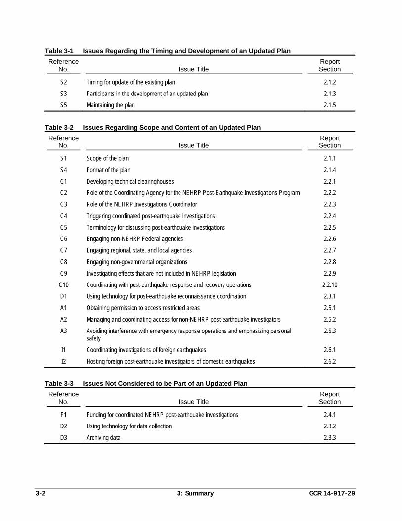
3-2 3: Summary GCR 14-917-29
Table 3-1 Issues Regarding the Timing and Development of an Updated Plan
Reference No.
Issue Title
Report Section
S2 Timing for update of the existing plan 2.1.2
S3 Participants in the development of an updated plan 2.1.3
S5 Maintaining the plan 2.1.5
Table 3-2 Issues Regarding Scope and Content of an Updated Plan
Reference No.
Issue Title
Report Section
S1 Scope of the plan 2.1.1
S4 Format of the plan 2.1.4
C1 Developing technical clearinghouses 2.2.1
C2 Role of the Coordinating Agency for the NEHRP Post-Earthquake Investigations Program 2.2.2
C3 Role of the NEHRP Investigations Coordinator 2.2.3
C4 Triggering coordinated post-earthquake investigations 2.2.4
C5 Terminology for discussing post-earthquake investigations 2.2.5
C6 Engaging non-NEHRP Federal agencies 2.2.6
C7 Engaging regional, state, and local agencies 2.2.7
C8 Engaging non-governmental organizations 2.2.8
C9 Investigating effects that are not included in NEHRP legislation 2.2.9
C10 Coordinating with post-earthquake response and recovery operations 2.2.10
D1 Using technology for post-earthquake reconnaissance coordination 2.3.1
A1 Obtaining permission to access restricted areas 2.5.1
A2 Managing and coordinating access for non-NEHRP post-earthquake investigators 2.5.2
A3 Avoiding interference with emergency response operations and emphasizing personal safety
2.5.3
I1 Coordinating investigations of foreign earthquakes 2.6.1
I2 Hosting foreign post-earthquake investigators of domestic earthquakes 2.6.2
Table 3-3 Issues Not Considered to be Part of an Updated Plan
Reference No.
Issue Title
Report Section
F1 Funding for coordinated NEHRP post-earthquake investigations 2.4.1
D2 Using technology for data collection 2.3.2
D3 Archiving data 2.3.3
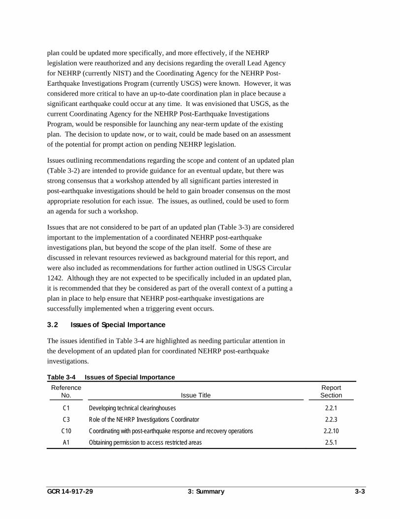
GCR 14-917-29 3: Summary 3-3
plan could be updated more specifically, and more effectively, if the NEHRP
legislation were reauthorized and any decisions regarding the overall Lead Agency
for NEHRP (currently NIST) and the Coordinating Agency for the NEHRP Post-
Earthquake Investigations Program (currently USGS) were known. However, it was
considered more critical to have an up-to-date coordination plan in place because a
significant earthquake could occur at any time. It was envisioned that USGS, as the
current Coordinating Agency for the NEHRP Post-Earthquake Investigations
Program, would be responsible for launching any near-term update of the existing
plan. The decision to update now, or to wait, could be made based on an assessment
of the potential for prompt action on pending NEHRP legislation.
Issues outlining recommendations regarding the scope and content of an updated plan
(Table 3-2) are intended to provide guidance for an eventual update, but there was
strong consensus that a workshop attended by all significant parties interested in
post-earthquake investigations should be held to gain broader consensus on the most
appropriate resolution for each issue. The issues, as outlined, could be used to form
an agenda for such a workshop.
Issues that are not considered to be part of an updated plan (Table 3-3) are considered
important to the implementation of a coordinated NEHRP post-earthquake
investigations plan, but beyond the scope of the plan itself. Some of these are
discussed in relevant resources reviewed as background material for this report, and
were also included as recommendations for further action outlined in USGS Circular
1242. Although they are not expected to be specifically included in an updated plan,
it is recommended that they be considered as part of the overall context of a putting a
plan in place to help ensure that NEHRP post-earthquake investigations are
successfully implemented when a triggering event occurs.
3.2 Issues of Special Importance
The issues identified in Table 3-4 are highlighted as needing particular attention in
the development of an updated plan for coordinated NEHRP post-earthquake
investigations.
Table 3-4 Issues of Special Importance
Reference No.
Issue Title
Report Section
C1 Developing technical clearinghouses 2.2.1
C3 Role of the NEHRP Investigations Coordinator 2.2.3
C10 Coordinating with post-earthquake response and recovery operations 2.2.10
A1 Obtaining permission to access restricted areas 2.5.1
3-4 3: Summary GCR 14-917-29
These issues were considered to have special importance because:
The concept of a local or regional clearinghouse is considered to be an excellent
coordination resource for NEHRP agencies, non-NEHRP agencies, and non-
governmental organizations, but developing such a resource will require
coordination in advance of the next earthquake. It is recommended that the plan
rely heavily on such clearinghouses, either those that are already in place, or one
set up for a specific event with the help of the Coordinating Agency for the
NEHRP Post-Earthquake Investigations Program, as discussed in Issue C1
(Section 2.2.1).
The role of the Investigation Coordinator is extremely important, but such a
position has no authority for directing the work of another agency. To be
effective, coordination agreements must be set up in advance, as discussed in
Issue C3 (Section 2.2.3).
It is recommended that, to the extent practicable, an updated plan be coordinated
with the National Response Framework and National Disaster Recovery
Framework and critical incident management systems, protocols, and practices,
as discussed in Issue C10 (Section 2.2.10).
Access to an earthquake disaster area is expected to become more restricted in
the future. NEHRP agencies should have plans in place for obtaining
permissions for NEHRP and partner organization investigators to gain access to
disaster areas in advance of an event. It is recommended that NEHRP agencies
coordinate with existing clearinghouses, organizations, and other local agencies
to identify possible solutions, as discussed in Issue A1 (Section 2.5.1).
3.3 Necessary Funding
It is important to note that many of the recommendations presented in this report
would require additional funding, beyond what appears to be allocated for post-
earthquake activities now, in order to be implemented in the most effective manner.
Agency funding allocations, however, were considered beyond the scope of the
development of a framework for an updated coordination plan.
Funding, as discussed in Issue F1 (Section 2.4.1), is critical to the actual
implementation of a post-earthquake investigation plan. Implicit with any decision to
implement the elements of an updated plan is the assumption that the necessary
funding will be provided. This policy issue requires action among the NEHRP
agencies, as well as other appropriate Federal agencies that may be involved in
developing funding mechanisms, to establish permanent and dedicated funding
sources for post-earthquake investigation coordination and planning activities, actual
field reconnaissance and investigation, and eventual post-earthquake analysis
activities.
GCR 14-917-29 A: Relevant Resources A-1
Appendix A
Relevant Resources
Past efforts, workshops, plans, publications, guidelines, documents, and
organizations were reviewed for information that might be relevant to NEHRP post-
earthquake investigation planning and coordination activities. This appendix
presents a bibliographical list of resources that were found to be most relevant,
divided into three categories based on degree of relevance: primary relevance,
secondary relevance, and tertiary relevance. Passages that describe the purpose and
content of each primary reference, and selected secondary references, are provided.
A.1 List of Relevant Resources
A.1.1 Primary Relevance
California Post-Earthquake Information Clearinghouse, 2009, Draft Operation Plan,
California Post-Earthquake Information Clearinghouse Management Group,
last accessed on September 16, 2013, http://www.californiaeqclearinghouse
.org/wp-content/uploads/2009/06/chplan090324.pdf. Also, annual exercises
to test various field data collection tools for use in post-earthquake
reconnaissance (e.g., 2013 Golden Guardian Exercise May 13-15, 2013).
EERI, 1996, Post-Earthquake Investigation Field Guide, Earthquake Engineering
Research Institute, Oakland, California.
EERI, 2003, Collection and Management of Earthquake Data: Defining Issues for An
Action Plan, Publication Number 2003-03, Earthquake Engineering Research
Institute, Oakland, California.
EERI, 2013, Earthquake Engineering Research Institute (EERI), Learning from
Earthquakes (LFE) Program: Operations, Earthquake Engineering Research
Institute, last accessed on September 23, 2013, https://www.eeri.org/cohost
/Learning%20from%20Earthquakes/EERI%20LFE%20Operations%20DRA
FT%20022513.pdf.
GEER, 2011, Manual for GEER Reconnaissance Teams, edited by Kayen, R.,
Geotechnical Extreme Events Reconnaissance Association, last accessed on
September 16, 2013, http://vqs751.pair.com/stevens3/asce/wp-content
/uploads/2013/05/Manual-GEER-Reconnaissance-Teams.pdf.
NIST, 2012, NIST Disaster and Failure Studies, National Institute of Standards and
Technology, last accessed on September 23, 2013, http://www.nist.gov/el
/disasterstudies/upload/NISTDisasterandFailureStudiesFactsheet111212.pdf .
A-2 A: Relevant Resources GCR 14-917-29
USGS, 2003, The Plan to Coordinate NEHRP Post-Earthquake Investigations,
Circular 1242, United States Geological Survey, Reston, Virginia.
A.1.2 Secondary Relevance
ACEHR, 2008, Effectiveness of the National Earthquake Hazards Reduction
Program, A Report from the Advisory Committee on Earthquake Hazards
Reduction, last accessed on September 16, 2013, http://www.nehrp.gov/pdf
/2008ACEHRReport.pdf .
ACEHR, 2010, Effectiveness of the National Earthquake Hazards Reduction
Program, A Report from the Advisory Committee on Earthquake Hazards
Reduction, Advisory Committee on Earthquake Hazards Reduction, last
accessed on September 16, 2013, http://www.nehrp.gov/pdf
/2010DraftACEHRReport.pdf.
American Lifelines Alliance, 2008, American Lifelines Alliance, Post-Earthquake
Information Systems (PIMS), Scoping Study, National Institute of Building
Sciences, Washington, D.C.
Boehlert, S., Bordogna, J., Hoffbuhr, J., Snell, J.W., and Wulf, W., 2008, Report on
Engineering Reviews: Recommendations to the American Society of Civil
Engineers, Task Force on Engineering Reviews, American Society of Civil
Engineers, Reston, Virginia.
Bray, J., Frost, D., and Rathje, E., 2011, “Turning disaster into knowledge,” Geo-
Strata, Vol. 15, No. 5, pp. 18, 20, 21, 26.
EERI, 2003, Securing Society Against Catastrophic Earthquake Losses: A Research
and Outreach Plan in Earthquake Engineering, Earthquake Engineering
Research Institute, Oakland, California.
FEMA, 2011, National Disaster Recovery Framework: Strengthening Disaster
Recovery for the Nation, Federal Emergency Management Agency,
Washington, D.C.
Kayen, R., and Collins, B., 2012, “Taking the measure of disaster with terrestrial
laser scanning,” Geo-Strata, Vol. 15, No. 4, pp. 14-20.
NEHRP, 2008, Strategic Plan for the National Earthquake Hazards Reduction
Program: Fiscal Years 2009-2013, Interagency Coordinating Committee of
the National Hazards Reduction Program, Gaithersburg, Maryland.
NIST, 2013, Disaster and Failure Studies Repository, National Institute of Standards
and Technology, last accessed on September 23, 2013, http://wtcdata.nist
.gov/.
NRC, 2006, Facing Hazards and Disasters: Understanding Human Dimensions,
Committee on Disaster Research in Social Sciences: Future Challenges and
GCR 14-917-29 A: Relevant Resources A-3
Opportunities, Division of Earth and Life Studies, National Research
Council, The National Academies Press, Washington, D.C.
NRC, 2011, Grand Challenges in Earthquake Engineering Research: A Community
Workshop Report, National Research Council, the National Academies Press,
Washington, D.C.
O’Rourke, T., Holzer, T., Rojahn, C., and Tierney, K., 2008, Contributions of
Earthquake Engineering to Protecting Communities and Critical
Infrastructure from Multihazards, Earthquake Engineering Research
Institute, Oakland, California.
Servin, V., 2010, New Techniques for Earthquake Reconnaissance, University of
California, Berkeley, last accessed on September 16, 2013, http://peer
.berkeley.edu/education/files/2010-Servin-Paper-FINAL.pdf.
A.1.3 Tertiary Relevance
Bardet, J.P., and Liu, F., 2010, “Towards virtual earthquakes: using post-earthquake
reconnaissance information,” Online Information Review, Vol. 34, No. 1,
pp. 59-74.
Bisch, P., Labbe, P., and Pecker, A., Eds., 1999, Proceedings, Eleventh European
Conference on Earthquake Engineering, Paris, France (the post-earthquake
investigations and feedback experience session papers are of particular
relevance).
Sardo, A.G., Sardo, T.E., and Harik, I.E., 2006, Post Earthquake Investigation Field
Manual for the State of Kentucky, Research Report KTC-06-30/SPR234-01-
1F, Kentucky Transportation Center, University of Kentucky, Lexington,
Kentucky.
Schiff, A.J., 1997, Guide to Post Earthquake Investigation of Lifelines, Technical
Council on Lifeline Earthquake Engineering, American Society of Civil
Engineers, Reston, Virginia.
WSSPC, 2001, Policy Recommendation 10-3: Post-Earthquake Technical
Clearinghouses, Western States Seismic Policy Council, Sacramento,
California.
A.2 Selected Passages from Relevant Resources
This section presents short passages from resources considered to be of primary
relevance, and selected resources of secondary relevance. These passages describe
the purpose or objective of the resource.
A-4 A: Relevant Resources GCR 14-917-29
A.2.1 USGS Circular 1242
The following passage is taken from USGS Circular 1242, The Plan to Coordinate
NEHRP Post-Earthquake Investigations (USGS, 2003):
“This is the plan to coordinate domestic and foreign post-earthquake
investigations supported by the National Earthquake Hazards Reduction Program
(NEHRP). The plan addresses coordination of both the NEHRP agencies—
Federal Emergency Management Agency (FEMA), National Institute of
Standards and Technology (NIST), National Science Foundation (NSF), and
U. S. Geological Survey (USGS)—and their partners. The plan is a framework
for both coordinating what is going to be done and identifying responsibilities for
post-earthquake investigations. It does not specify what will be done.
Coordination is addressed in various time frames ranging from hours to years
after an earthquake. The plan includes measures for (1) gaining rapid and
general agreement on high-priority research opportunities, and (2) conducting the
data gathering and field studies in a coordinated manner. It deals with
identification, collection, processing, documentation, archiving, and
dissemination of the results of post-earthquake work in a timely manner and
easily accessible format.
For the purposes of this plan a significant domestic earthquake is defined as
either (1) an earthquake resulting in a Presidential disaster declaration, or (2) an
earthquake considered by NEHRP agencies to provide an opportunity to learn
how to reduce future earthquake losses in the United States. The plan organizes
domestic post-earthquake investigation and information dissemination activities
into three phases…”
A.2.2 EERI Collection and Management of Earthquake Data
The following passage is taken from EERI’s Collection and Management of
Earthquake Data: Defining Issues for An Action Plan (EERI, 2003):
“The earthquake community stands at a critical juncture in terms of how it learns
about earthquakes. Rapid and profound changes in the technology used for data
acquisition, computing and information management now allow the community
to consider acquiring, analyzing and managing data in new ways. Improving the
collection and management of data, immediately in post-earthquake
reconnaissance as well as in long-term impact assessments, are central to
improving knowledge gained from earthquakes. To help define these issues,
EERI held an invitational workshop on September 19th and 20th, 2002, in
Pasadena, California.
Over seventy members of the broad earthquake community, representing a wide
range of disciplines and skills, came together for two days of brainstorming
GCR 14-917-29 A: Relevant Resources A-5
sessions and discussion, developing preliminary recommendations that have been
organized and are presented in this report. The recommendations are organized
in three major categories: Improving Data Collection, Supporting Data Access
and Improving Data Organization and Use. The various suggestions and ideas
related to each of these three large concepts have been incorporated in the
following recommendations. Because the workshop participants took a broad
approach to this topic, priorities and specific funding requirements are not
attached to these recommendations. Rather, the authors urge the establishment
and funding of a series of focused working groups that will tackle these issues in
a more systematic manner.”
A.2.3 EERI Post-Earthquake Investigation Field Guide
The following passage is taken from EERI’s Post-Earthquake Investigation Field
Guide (EERI, 1996):
“This Post-Earthquake Investigation Field Guide (hereafter called Field Guide)
stresses advance planning. It outlines procedures that enable EERI to dispatch
investigation teams quickly and effectively when the need arises. This advance
planning is essential if EERI is to use its resources to best advantage, avoid
duplicating the efforts of others, and ensure that all important aspects of
destructive earthquakes are adequately studied. This Post-Earthquake
Investigation Field Guide describes procedures for deciding what earthquakes
will be investigated; responsibilities of project participants; formation and
dispatch of investigation teams; and dissemination of the information collected.
It also offers guidelines for specific data collection in the field.”
A.2.4 Manual for GEER Reconnaissance Teams
The following passage is taken from the Manual for GEER Reconnaissance Teams
(GEER, 2011):
“The purpose of this manual is to standardize reconnaissance practices among
researchers so to maintain safety in the field, improve the overall quality of the
data collection effort, and to best organize the findings for digital report and map
delivery. The improvement of this manual is a GEER membership-wide
responsibility. Your suggestions and input are essential in order to improve the
usefulness of this manual for the next GEER field effort.
The primary goals of the GEER team is to survey the damaging geotechnical
aspects of the event, to document key sites to develop well-documented case
histories, and to identify opportunities for further research. Reconnaissance has
served an important role in earthquake engineering research and have led to
significant advancements in our understanding of geoengineering phenomena
such as surface fault rupture, ground motions, site effects, soil liquefaction,
A-6 A: Relevant Resources GCR 14-917-29
ground failure, slope instabilities, the performance of buildings, foundations,
earth structures, and improved ground.”
A.2.5 California Post-Earthquake Information Clearinghouse Draft Operation Plan
The following passage is taken from the California Post-Earthquake Information
Clearinghouse, Draft Operation Plan (2009):
“The California Post-Earthquake Information Clearinghouse was established in
1972 to provide State and Federal disaster response managers, affected agencies,
and the scientific community with prompt information on ground failure,
structural damage, and other consequences of a significant seismic event. The
information is collected by scores of scientist, engineers, and other professionals
who commonly arrive in affected areas to conduct research and/or assist in a
Clearinghouse operation. The Clearinghouse core group is a collection of earth
scientists, engineers and other professionals representing various state agencies,
federal bureaus, universities, and private institutions. The group meets on a tri-
annual basis to maintain operational preparedness and strong working
relationships among the participating organizations.
Mission Statement: To facilitate the gathering and dissemination of post-
earthquake information using the talents of scientists, engineers, sociologists,
economists, and other professionals who arrive in the affected area.”
A.2.6 EERI Learning from Earthquakes Program Operations
The following passage is taken from Earthquake Engineering Research Institute
(EERI), Learning from Earthquakes (LFE) Program, Operations (EERI, 2013):
“The purpose of this document is to define protocols for operations of the LFE
program to maximize benefits to the Institute, the EERI membership, and society
as a whole.”
A.2.7 NIST Disaster and Failure Studies Fact Sheet
The following passage is taken from the NIST Disaster and Failure Studies fact sheet
(NIST, 2012):
“The objectives of NIST's disaster and failure studies may include:
1. Establishing the likely technical factor or factors responsible for the damage,
failure, and/or successful performance of buildings and/or infrastructure in
the aftermath of a disaster or failure event;
GCR 14-917-29 A: Relevant Resources A-7
2. Evaluating the technical aspects of evacuation and emergency response
procedures that contributed to the extent of injuries and fatalities sustained
during the event;
3. Determining the procedures and practices that were used in the design,
construction, operation, and maintenance of the buildings and/or
infrastructure; and
4. Recommending, as necessary, specific improvements to standards, codes,
and practices as well as any research and other appropriate actions based on
study findings.”
A.2.8 Report on Engineering Reviews to the American Society of Civil Engineers
The following passage is taken from Report on Engineering Reviews:
Recommendations to the American Society of Civil Engineers (Boehlert et al., 2008):
“The Task Force believes ASCE remains the best option for our nation in
conducting post disaster engineering assessments. However, the overall process
by which future disaster engineering assessments are conducted must be
improved to reflect emerging complexities in assessing disasters and evolving
societal expectations. The Task Force identified four basic areas of needed
reform; process transparency and efficacy, the funding of engineering reviews,
communication with the public and press, and potential conflicts of interest.”
A.2.9 Effectiveness of the National Earthquake Hazards Reduction Program
The following passage is taken from Effectiveness of the National Earthquake
Hazards Reduction Program, A Report from the Advisory Committee on Earthquake
Hazards Reduction (ACEHR, 2008):
“Consistent with the change in the leadership of the NEHRP, ACEHR believes
that the Program would benefit from a similar change in leadership related to
post-earthquake investigations. Section 11 of Public Law 108-360 establishes a
post-earthquake investigation program within USGS that involves NSF, NIST, as
well as other federal agencies and private contractors. USGS Circular 1242
provides a road map for implementation. ACEHR fully supports the need for
post-earthquake investigation, believes the Circular must be updated, and sees the
following opportunities for significantly improving our ability to gather and
process critical and perishable data immediately after an event.
Assign discipline-oriented teams to investigate each facet of the earthquake
rather than a single team with individual representatives of each discipline.
Each team should be funded by its related organization or agency. Teams
A-8 A: Relevant Resources GCR 14-917-29
should be identified to investigate earth science, geo-engineering, and
lifelines, structural, social, and economic aspects of each major event.
USGS should delegate leadership to an organization without any discipline-
related responsibility, such as the NEHRP Secretariat, which can serve as the
single point of coordination. Staff and funding must be provided to refine
the response program, identify available participants, and maintain a state of
response readiness.
The results of the investigations and related research should be gathered and
archived in the Post-Earthquake Information Management System (PIMS)
and published in a set of discipline-oriented volumes that document in detail
the immediate and long-term impacts of the event.”
GCR 14-917-29 B: Standard Nomenclature B-1
Appendix B
Standard Nomenclature
Each NEHRP agency might use different terminology, or define specific terms in
different ways, which could impede post-earthquake coordination. This appendix
presents a list of terms and definitions collected as an illustrative example and
possible starting point for future development of a standard nomenclature. This list is
not intended to be all-inclusive, nor is it intended to definitively establish any
definitions at this time.
Many of the definitions provided in this appendix were developed by the United
Nations Office for Disaster Risk Reduction (UNISDR) and can be found at
http://www.unisdr.org/we/inform/terminology. The terminology was developed for
basic terms related to disaster risk reduction to promote a common understanding on
the subject for use by the public, authorities, and practitioners. The UNISDR
definitions, intended for an international audience, may or may not be relevant to
NEHRP post-earthquake investigations. It was deemed appropriate for this effort,
however, to present the UNISDR definitions as a possible source of terminology, so
that decisions could be made on the basis of a broad perspective.
There are other potential sources that should be examined in developing a standard
nomenclature for NEHRP post-earthquake investigations. A preliminary review of
these sources was conducted for this appendix, but a more thorough examination of
these sources (and similar documents) is recommended for future efforts. Selected
Federal documents, such as the following, should be considered:
National Response Framework (NRF)
National Mitigation Framework (NMF)
National Disaster Recovery Framework (NDRF)
National Infrastructure Protection Plan (NIPP)
Presidential Policy Directive/PPD-21: Critical Infrastructure Security and
Resilience (PPD-21)
The primary source of the definition of each term is provided in parentheses at the
end of each definition. Definitions without an identifiable source were written by the
project team. Some terms are more relevant to coordination of post-earthquake
investigations than others, but all of the terms identified during this effort were
retained for the purpose of this report. In the eventual development of a standard
B-2 B: Standard Nomenclature GCR 14-917-29
nomenclature, an effort should be undertaken to include only those terms that are
most relevant to a NEHRP post-earthquake investigation plan, or those that could
cause confusion or hinder coordination following an earthquake.
Acceptable Risk (source: UNISDR). The level of potential losses that a society or
community considers acceptable given existing social, economic, political, cultural,
technical, and environmental conditions. Comment: In engineering terms, acceptable
risk is also used to assess and define the structural and nonstructural measures that
are needed to reduce possible harm to people, property, services, and systems to a
chosen tolerated level, according to codes or “accepted practices,” which are based
on known probabilities of hazard and other factors.
All-Hazards (source: NIPP). A grouping classification encompassing all
conditions, environmental or manmade, that have the potential to cause injury,
illness, or death; damage to or loss of equipment, infrastructure services, or property;
or alternatively causing functional degradation to social, economic, or environmental
aspects.
Building Code (source: UNISDR). A set of ordinances or regulations and
associated standards intended to control aspects of the design, construction, materials,
alteration, and occupancy of structures that are necessary to ensure human safety and
welfare, including resistance to collapse and damage. Comment: Building codes can
include both technical and functional standards. They should incorporate lessons of
international experience, and should be tailored to national and local circumstances.
A systematic regime of enforcement is a critical supporting requirement for effective
implementation of building codes.
Case Study, Post-Earthquake. An in-depth study of an earthquake or its effects,
considered broadly, or isolated to an individual facility or societal aspect.
Catastrophic Incident (source: NDRF). Any natural or man-made incident,
including terrorism, that results in extraordinary levels of mass casualties, damage, or
disruption severely affecting the population, infrastructure, environment, economy,
national morale, or government functions. A catastrophic event could result in
sustained national impacts over a prolonged period of time; almost immediately
exceeds resources normally available to local, state, tribal, and private sector
authorities in the impacted area; and significantly interrupts governmental operations
and emergency services to such an extent that national security could be threatened.
(The) Charter. See “International Charter for Space and Major Disasters.”
Community (source: NDRF). A network of individuals and families, businesses,
governmental and non-governmental organizations and other civic organizations that
GCR 14-917-29 B: Standard Nomenclature B-3
reside or operate within a shared geographical boundary and may be represented by a
common political leadership at a regional, county, municipal or neighborhood level.
Coping Capacity (source: UNISDR). The ability of people, organizations and
systems, using available skills and resources, to face and manage adverse conditions,
emergencies or disasters. Comment: The capacity to cope requires continuing
awareness, resources, and good management, both in normal times as well as during
crises or adverse conditions. Coping capacities contribute to the reduction of disaster
risks.
Corrective Disaster Risk Management (source: UNISDR). Management activities
that address and seek to correct or reduce disaster risks which are already present.
Comment: This concept aims to distinguish between the risks that are already
present, and which need to be managed and reduced now, and the prospective risks
that may develop in the future if risk reduction policies are not put in place. See also
“Prospective Disaster Risk Management.”
Critical Facilities (source: UNISDR). The primary physical structures, technical
facilities, and systems that are socially, economically, or operationally essential to the
functioning of a society or community, both in routine circumstances and in the
extreme circumstances of an emergency. Comment: Critical facilities are elements of
the infrastructure that support essential services in a society. They include such
things as transport systems, air and sea ports, electricity, water and communications
systems, hospitals and health clinics, and centers for fire, police and public
administration services. The term also refers to those facilities, such as a dam or
nuclear power plant, the failure of which may have widespread and devastating
effects beyond the facility itself.
Critical Infrastructure (source: NDRF). Systems and assets, whether physical or
virtual, so vital that the incapacity or destruction of such may have a debilitating
impact on the security, economy, public health or safety, environment, or any
combination of these matters, across any local, state, tribal and Federal jurisdiction.
Damage Assessment, Post-Earthquake. The assessment, usually by an engineer, of
the condition of a constructed facility, usually emphasizing the safety condition.
Data. Quantitative, factual, reproducible, and archivable information directly
observed in the field or through remote sensors that can be used to assess the cause,
effects, or impacts of an earthquake.
Data Archive. A computer-based system for the storage and retrieval of post-
earthquake data.
Data Collection. Any process involved in obtaining data.
B-4 B: Standard Nomenclature GCR 14-917-29
Data, Perishable. Data (information) relevant to a post-earthquake situation that
may be short-lived and lost due to recovery, rebuilding, or natural causes.
Data Processing. Any process involved in the organization, reduction, or analysis of
data.
Disaster (source: UNISDR). A serious disruption of the functioning of a
community or society involving widespread human, material, economic, or
environmental losses and impacts, which exceeds the ability of the affected
community or society to cope using its own resources. Comment: Disasters are often
described as a result of the combination of the exposure to a hazard, the conditions of
vulnerability that are present, and insufficient capacity or measures to reduce or cope
with the potential negative consequences. Disaster impacts may include loss of life,
injury, disease, and other negative effects on human physical, mental and social well-
being, together with damage to property, destruction of assets, loss of services, social
and economic disruption and environmental degradation.
Disaster and Failure Events Data Repository (source: NIST). A repository of
images, videos, and documents collected during and after disaster and failure events
studied by the National Institute of Standards and Technology, as well as data
generated from research on those events. The materials in the repository serve as an
historical archive.
Disaster Assistance Process. The process by which the Federal government,
primarily through FEMA and the U.S. Small Business Administration, provide
disaster assistance authorized under the Stafford Act. This assistance includes
individual assistance, public assistance, U.S. Small Business Administration disaster
loans, and FEMA grants.
Disaster Mitigation Act of 2000. Public Law 106-390 (also referred to as DMA2K),
which amended the Stafford Act provisions related to disaster relief. It revised and
broadened the scope of existing disaster relief programs, encouraged better disaster
preparedness, improved coordination between programs, and encouraged improved
hazard mitigation.
Disaster Risk (source: UNISDR). The potential disaster losses, in lives, health
status, livelihood, assets, and services, which could occur to a particular community
or society over some specified future time period. Comment: The definition of
disaster risk reflects the concept of disasters as the outcome of continuously present
conditions of risk. Disaster risk comprises different types of potential losses, which
are often difficult to quantify. Nevertheless, with knowledge of the prevailing
hazards and the patterns of population and socioeconomic development, disaster risks
can be assessed and mapped, at least in broad terms.
GCR 14-917-29 B: Standard Nomenclature B-5
Disaster Risk Management (source: UNISDR). The systematic process of using
administrative directives, organizations, and operational skills and capacities to
implement strategies, policies, and improved coping capacities in order to lessen the
adverse impacts of hazards and the possibility of disaster. Comment: This term is an
extension of the more general term “risk management” to address the specific issue
of disaster risks. Disaster risk management aims to avoid, lessen, or transfer the
adverse effects of hazards through activities and measures for prevention, mitigation
and preparedness.
Disaster Risk Reduction (source: UNISDR). The concept and practice of reducing
disaster risks through systematic efforts to analyze and manage the causal factors of
disasters, including through reduced exposure to hazards, lessened vulnerability of
people and property, wise management of land and the environment, and improved
preparedness for adverse events. Comment: A comprehensive approach to reduce
disaster risks is set out in the United Nations-endorsed Hyogo Framework for Action
2005-2015: Building the Resilience of Nations and Communities to Disasters (United
Nations, 2007), whose expected outcome is “The substantial reduction of disaster
losses, in lives and the social, economic and environmental assets of communities
and countries.” The International Strategy for Disaster Reduction (ISDR) system
provides a vehicle for cooperation among Governments, organizations and civil
society actors to assist in the implementation of the Framework. Note that while the
term “disaster reduction” is sometimes used, the term “disaster risk reduction”
provides a better recognition of the ongoing nature of disaster risks and the ongoing
potential to reduce these risks.
Disaster Risk Reduction Plan (source: UNISDR). A document prepared by an
authority, sector, organization, or enterprise that sets out goals and specific objectives
for reducing disaster risks together with related actions to accomplish these
objectives. Comment: Disaster risk reduction plans should be guided by the Hyogo
Framework (United Nations, 2007), and considered and coordinated within relevant
development plans, resource allocations and program activities. National level plans
needs to be specific to each level of administrative responsibility and adapted to the
different social and geographical circumstances that are present. The time frame and
responsibilities for implementation and the sources of funding should be specified in
the plan. Linkages to climate change adaptation plans should be made where
possible.
Early Warning System (source: UNISDR). The set of capacities needed to
generate and disseminate timely and meaningful warning information to enable
individuals, communities, and organizations threatened by a hazard to prepare and to
act appropriately and in sufficient time to reduce the possibility of harm or loss.
Comment: This definition encompasses the range of factors necessary to achieve
effective responses to warnings. A people-centered early warning system necessarily
B-6 B: Standard Nomenclature GCR 14-917-29
comprises four key elements: knowledge of the risks; monitoring, analysis, and
forecasting of the hazards; communication or dissemination of alerts and warnings;
and local capabilities to respond to the warnings received. The expression “end-to-
end warning system” is also used to emphasize that warning systems need to span all
steps from hazard detection through to community response.
Emergency Management (source: UNISDR). The organization and management
of resources and responsibilities for addressing all aspects of emergencies, in
particular preparedness, response, and initial recovery steps. Comment: A crisis or
emergency is a threatening condition that requires urgent action. Effective
emergency action can avoid the escalation of an event into a disaster. Emergency
management involves plans and institutional arrangements to engage and guide the
efforts of government, non-governmental, voluntary, and private agencies in
comprehensive and coordinated ways to respond to the entire spectrum of emergency
needs. The expression “disaster management” is sometimes used instead of
emergency management.
Emergency Response. See “Response.”
Emergency Services (source: UNISDR). The set of specialized agencies that have
specific responsibilities and objectives in serving and protecting people and property
in emergency situations. Comment: Emergency services include agencies such as
civil protection authorities, police, fire, ambulance, paramedic and emergency
medicine services, Red Cross and Red Crescent Societies, and specialized emergency
units of electricity, transportation, communications, and other related services
organizations.
Evaluation, Post-Earthquake. A post-earthquake evaluation is an assessment of the
condition of a structure following an earthquake. See also “Post-earthquake safety
evaluation of buildings.”
Event Website. A website established and maintained to serve as a repository of
various data related to an earthquake event. Comment: USGS establishes an event
page with technical, scientific, and impact information immediately following
earthquakes.
Exposure (source: UNISDR). People, property, systems, or other elements present
in hazard zones that are subject to potential losses. Comment: Measures of exposure
can include the number of people or types of assets in an area. These can be
combined with the specific vulnerability of the exposed elements to any particular
hazard to estimate the quantitative risks associated with that hazard in the area of
interest.
GCR 14-917-29 B: Standard Nomenclature B-7
Extensive Risk (source: UNISDR). The widespread risk associated with the
exposure of dispersed populations to repeated or persistent hazard conditions of low
or moderate intensity, often of a highly localized nature, which can lead to
debilitating cumulative disaster impacts. Comment: Extensive risk is mainly a
characteristic of rural areas and urban margins where communities are exposed to,
and vulnerable to, recurring localized floods, landslides storms or drought. Extensive
risk is often associated with poverty, urbanization and environmental degradation.
See also “Intensive Risk.”
Field Office. See “Joint Field Office.”
Field Studies. Studies involved in the collection of post-earthquake data and
information at or near the site of the epicenter of the earthquake or any site impacted
by the event.
Field Technical Clearinghouse (source: USGS Circular 1242). A place within the
region affected by an earthquake where post-earthquake field investigators can meet
to review progress and to organize and coordinate their activities. For large events,
multiple places might be appropriate.
Forecast (source: UNISDR). Definite statement or statistical estimate of the likely
occurrence of a future event or conditions for a specific area.
Geological Hazard (source: UNISDR). Geological process or phenomenon that
may cause loss of life, injury or other health impacts, property damage, loss of
livelihood and services, social and economic disruption, or environmental damage.
Comment: Geological hazards include internal earth processes, such as earthquakes,
volcanic activity and emissions, and related geophysical processes such as mass
movements, landslides, rockslides, surface collapses, and debris or mud flows.
Hydrometeorological factors are important contributors to some of these processes.
Tsunamis are difficult to categorize; although they are triggered by undersea
earthquakes and other geological events, they are essentially an oceanic process that
is manifested as a coastal water-related hazard.
Hazard (source: UNISDR). A dangerous phenomenon, substance, human activity,
or condition that may cause loss of life, injury or other health impacts, property
damage, loss of livelihood and services, social and economic disruption, or
environmental damage. Comment: The hazards of concern to disaster risk reduction
as stated in the Hyogo Framework are “… hazards of natural origin and related
environmental and technological hazards and risks,” (United Nations, 2007). Such
hazards arise from a variety of geological, meteorological, hydrological, oceanic,
biological, and technological sources, sometimes acting in combination. In technical
settings, hazards are described quantitatively by the likely frequency of occurrence of
different intensities for different areas, as determined from historical data or scientific
B-8 B: Standard Nomenclature GCR 14-917-29
analysis. See other hazard-related terms: “Geological Hazard; Natural Hazard;
Socio-Natural Hazard; Technological Hazard.”
Hazards Data Distribution System. A resource maintained by USGS that provides
quick and easy access to imagery and geospatial data that supports emergency
response and recovery operations. The Hazards Data Distribution System (HDDS)
provides data access and delivery services through graphic or traditional directory-
based interfaces that allow emergency response personnel to select and obtain pre-
event baseline and post-event emergency response imagery.
HAZUS. A GIS-based, nationally applicable standardized methodology developed,
maintained and distributed by FEMA for estimating potential losses from
earthquakes, floods, and hurricanes.
Intensive Risk (source: UNISDR). The risk associated with the exposure of large
concentrations of people and economic activities to intense hazard events, which can
lead to potentially catastrophic disaster impacts involving high mortality and asset
loss. Comment: Intensive risk is mainly a characteristic of large cities or densely
populated areas that are not only exposed to intense hazards, such as strong
earthquakes, active volcanoes, heavy floods, tsunamis, or major storms, but also have
high levels of vulnerability to these hazards.
Intermediate Recovery (source: NDRF). Phase of recovery which involves
returning individuals, families, critical infrastructure and essential government or
commercial services to a functional, if not pre-disaster, state. Such activities are
often characterized by temporary actions that provide a bridge to permanent
measures.
International Charter for Space and Major Disasters. The International Charter
for Space and Major Disasters aims to provide a unified system of space data
acquisition and delivery to those affected by natural or man-made disasters through
authorized users. Each member agency has committed resources to support the
provisions of the Charter and thus is helping to mitigate the effects of disasters on
human life and property.
Inventory. Usually refers to the building stock of a community, with information on
building and construction types, construction age, numbers of buildings, and
occupancy. May also refer to other constructed facilities, such as bridges.
Investigation, Post-Earthquake. Studies of the cause, effects, and impacts of an
earthquake and the publication of the results of these studies.
Joint Field Office. An administrative office established at the scene of a Presidential
disaster declaration.
GCR 14-917-29 B: Standard Nomenclature B-9
Land-Use Planning (source: UNISDR). The process undertaken by public
authorities to identify, evaluate, and decide on different options for the use of land,
including consideration of long-term economic, social, and environmental objectives
and the implications for different communities and interest groups, and the
subsequent formulation and promulgation of plans that describe the permitted or
acceptable uses. Comment: Land-use planning is an important contributor to
sustainable development. It involves studies and mapping; analysis of economic,
environmental, and hazard data; formulation of alternative land-use decisions; and
design of long-range plans for different geographical and administrative scales.
Land-use planning can help to mitigate disasters and reduce risks by discouraging
settlements and construction of key installations in hazard-prone areas, including
consideration of service routes for transport, power, water, sewage, and other critical
facilities.
Long-Term Recovery (source: NDRF). Phase of recovery that may continue for
months or years and addresses complete redevelopment and revitalization of the
impacted area, rebuilding or relocating damaged or destroyed social, economic,
natural and built environments and a move to self-sufficiency, sustainability and
resilience.
Major Disaster (source: NDRF). As defined by the Stafford Act, any natural
catastrophe (including any hurricane, tornado, storm, high water, wind-driven water,
tidal wave, tsunami, earthquake, volcanic eruption, landslide, mudslide, snowstorm,
or drought) or, regardless of cause, any fire, flood or explosion, in any part of the
United States, which in the determination of the President causes damage of
sufficient severity and magnitude to warrant major disaster assistance to supplement
the efforts and available resources of local, state governments and disaster relief
organizations in alleviating the damage, loss, hardship or suffering caused thereby.
Mitigation (sources: NRDF, FEMA, and UNISDR). Capabilities necessary to
reduce loss of life and property by lessening the impact of disasters. Mitigation
capabilities include: community-wide risk reduction projects; efforts to improve the
resilience of critical infrastructure and key resource lifelines; risk reduction for
specific vulnerabilities from natural hazards or acts of terrorism; initiatives to reduce
future risks after a disaster has occurred; and actions taken before a disaster to reduce
adverse impacts of hazards and related disasters. Actions can include analyzing risk,
reducing risk, and insuring against risk. Comment: The adverse impacts of hazards
often cannot be prevented fully, but their scale or severity can be substantially
lessened by various strategies and actions. Mitigation measures encompass
engineering techniques and hazard-resistant construction, as well as improved
environmental policies and public awareness. It should be noted that in climate
change policy, “mitigation” is defined differently, being the term used for the
reduction of greenhouse gas emissions that are the source of climate change.
B-10 B: Standard Nomenclature GCR 14-917-29
Mitigation Assessment Team Program (source: FEMA). Mitigation Assessment
Team (MAT) is a FEMA program, drawing on the combined resources of a Federal,
state, local, and private sector partnership, to assemble and quickly deploy teams of
investigators to: (1) inspect buildings and related infrastructure; (2) conduct forensic
engineering analyses to determine causes of structural failure and success; and (3)
recommend actions that state and local governments, the construction industry, and
building code organizations can take to reduce future damages and protect lives and
property in hazard areas.
National Construction Safety Team Act. National Construction Safety Team
(NCST) Act is the law authorizing NIST to establish teams, dispatched within 48
hours after major building disasters to: (1) establish the likely technical cause of
building failures; (2) evaluate the technical aspects of procedures used for evacuation
and emergency response; (3) recommend specific changes to building codes,
standards, and practices; (4) recommend any research or other appropriate actions
needed to improve the structural safety of buildings, or changes in emergency
response and evacuation procedures; and (5) make final recommendations within 90
days of completing an investigation.
Natural Hazard (source: UNISDR). Natural process or phenomenon that may
cause loss of life, injury or other health impacts, property damage, loss of livelihood
and services, social and economic disruption, or environmental damage. Comment:
Natural hazards are a subset of all hazards. The term is used to describe actual
hazard events as well as the latent hazard conditions that may give rise to future
events. Natural hazard events can be characterized by their magnitude or intensity,
speed of onset, duration, and area of extent. For example, earthquakes have short
durations and usually affect a relatively small region, whereas droughts are slow to
develop, fade away, and often affect large regions. In some cases hazards may be
coupled, such in flooding caused by a hurricane or the tsunami that is caused by an
earthquake.
NEHRP Investigations Coordinator (source: USGS Circular 1242). An
individual designated by USGS to: (1) ensure that disaster response activities are not
impeded by scientific and technical investigations; (2) provide emergency managers
with timely and relevant information from the ongoing field investigations; (3)
facilitate coordination of NEHRP agencies; (4) ensure that NEHRP press releases are
coordinated and consistent; and (5) to work with scientific and engineering leaders to
identify critical investigations and gaps in the ongoing investigation. The NEHRP
agencies are not authorized to delegate authority to the Investigations Coordinator;
therefore, that individual operates under voluntary cooperation with the program
managers of the NEHRP agencies.
GCR 14-917-29 B: Standard Nomenclature B-11
NEHRP Post-Earthquake Coordination Plan. The post-earthquake coordination
plan as described in USGS Circular 1242.
Post-Earthquake Information Management System. A proposed national
information management system to facilitate post-earthquake data collection, data
archiving, and use of data to improve protection against hazards.
Post-Earthquake Investigation Selection Committee. A standing committee
proposed in USGS Circular 1242, with responsibility to assist the lead agency to
identify investigation topics, distribution of funds, and reporting of results to
Congress.
Post-Earthquake Safety Evaluation of Buildings. An assessment of the safety
condition of a building following an earthquake. Maintained by the Applied
Technology Council and referred to as ATC-20, this process is a widely accepted
standard used by the local authority having jurisdiction for post-earthquake safety
review and placarding, designed to allow the inspector to rapidly review a building
and determine if it can be occupied (green – inspected placard), requires additional
reviews or has partial damage (yellow – restricted use placard), or should be closed
until demolition or upgrading (red – unsafe placard).
Preparedness (source: UNISDR). The knowledge, activities, and capacities
developed by governments, professional response and recovery organizations,
communities, and individuals prior to a disaster to help more effectively anticipate,
respond to, and recover from the impacts of likely, imminent, or current hazard
events or conditions. Comment: Preparedness action is carried out within the context
of disaster risk management and aims to build the capacities needed to efficiently
manage all types of emergencies and achieve orderly transitions from response
through to sustained recovery. Preparedness is based on a sound analysis of disaster
risks and good linkages with early warning systems, and includes such activities as
contingency planning; stockpiling of equipment and supplies; the development of
arrangements for coordination, evacuation, and public information; and associated
training and field exercises. These must be supported by formal institutional, legal,
and budgetary capacities. The related term “readiness” describes the ability to
quickly and appropriately respond when required.
Presidential Emergency and Disaster Declaration. A disaster declaration issued
by the President if a state submits a local emergency declaration and a state
emergency proclamation, and if the situation is beyond the coping capabilities of the
state and local governments. See also “Stafford Act.”
Prompt Assessment of Global Earthquakes for Response (source: USGS).
Prompt Assessment of Global Earthquakes for Response (PAGER) is a USGS system
that provides fatality and economic loss impact estimates following significant
B-12 B: Standard Nomenclature GCR 14-917-29
earthquakes worldwide. PAGER does not directly consider secondary effects, such
as landslides and tsunami.
Prospective Disaster Risk Management (Source: UNISDR). Management
activities that address and seek to avoid the development of new or increased disaster
risks. Comment: This concept focuses on addressing risks that may develop in future
if risk reduction policies are not put in place, rather than on the risks that are already
present and that can be managed and reduced now. See also “Corrective Disaster
Risk Management.”
Public Awareness (source: UNISDR). The extent of common knowledge about
disaster risks, the factors that lead to disasters, and the actions that can be taken
individually and collectively to reduce exposure and vulnerability to hazards.
Comment: Public awareness is a key factor in effective disaster risk reduction. Its
development is pursued, for example, through the development and dissemination of
information through media and educational channels; the establishment of
information centers, networks, and community or participation actions; and advocacy
by senior public officials and community leaders.
Reconnaissance, Post-Earthquake. The observation and data collection activities
of engineers, earth scientists, and social scientists within the epicentral area, for the
purpose of reporting on the extent of the earthquake effects. Comment: In addition to
reporting the physical effects, reconnaissance teams should also report on the living
and transportation conditions and make recommendations for the size and expertise
needed in follow-up investigation teams.
Recovery (sources: NDRF, UNISDR). Those capabilities necessary to assist
communities affected by an incident to recover effectively, including rebuilding
infrastructure systems; providing adequate interim and long-term housing for
survivors; restoring health, social, and community services; promoting economic
development; and restoring natural and cultural resources. Also, the restoration, and
improvement of facilities, livelihood, and living conditions in disaster-affected
communities, including efforts to reduce disaster risk factors. Comment: The
recovery task of rehabilitation and reconstruction begins soon after the emergency
phase has ended, and should be based on pre-existing strategies and policies that
facilitate clear institutional responsibilities for recovery action and enable public
participation. Recovery programs, coupled with the heightened public awareness and
engagement after a disaster, afford a valuable opportunity to develop and implement
disaster risk reduction measures and to apply the “build back better” principle.
Research. In the context of post-earthquake investigations, the study of data
collected in these investigations to determine the geologic cause of the event, the
reasons for structural failures and other damages, and the social and economic
GCR 14-917-29 B: Standard Nomenclature B-13
impacts. Comment: Research activities usually follow the post-earthquake
investigation phase and are funded separately. Such activities can be short-term
(weeks and months) to long-term (years) in duration.
Residual Risk (source: UNISDR). The risk that remains in unmanaged form, even
when effective disaster risk reduction measures are in place, and for which
emergency response and recovery capacities must be maintained. Comment: The
presence of residual risk implies a continuing need to develop and support effective
capacities for emergency services, preparedness, response, and recovery together
with socioeconomic policies such as safety nets and risk transfer mechanisms.
Resilience (source: various). The ability to prepare for and adapt to changing
conditions and withstand and recover rapidly from disruptions (UNISDR).
Resilience includes the ability to withstand and recover from deliberate attacks,
accidents, or naturally occurring threats or incidents (PPD-21). Ability to adapt to
changing conditions and withstand and rapidly recover from disruption due to
emergencies (NDRF). The ability of a system, community, or society exposed to
hazards to resist, absorb, accommodate to, and recover from the effects of a hazard in
a timely and efficient manner, including through the preservation and restoration of
its essential basic structures and functions.
Response (source: various). Those capabilities necessary to save lives, protect
property and the environment, and meet basic human needs after an incident has
occurred (UNISDR). The provision of emergency services and public assistance
during, or immediately after, a disaster in order to save lives, reduce health impacts,
ensure public safety, and meet the basic subsistence needs of the people affected.
Comment: Disaster response is predominantly focused on immediate and short-term
needs and is sometimes called “disaster relief.” The division between this response
stage and the subsequent recovery stage is not clear-cut. Some response actions, such
as the supply of temporary housing and water supplies, may extend well into the
recovery stage (NDRF).
Restoration (source: NDRF). Returning a physical structure, essential government
or commercial services or a societal condition back to a former or normal state of use
through repairs, rebuilding, or reestablishment.
Retrofitting (source: UNISDR). Reinforcement or upgrading of existing structures
to become more resistant and resilient to the damaging effects of hazards. Also
known as rehabilitation. Comment: Retrofitting requires consideration of the design
and function of the structure, the stresses that the structure may be subject to from
particular hazards or hazard scenarios, and the practicality and costs of different
retrofitting options. Examples of retrofitting include adding bracing to stiffen walls,
B-14 B: Standard Nomenclature GCR 14-917-29
reinforcing columns, adding steel ties between walls and roofs, and improving the
protection of important facilities and equipment.
Risk (source: various). The potential for an unwanted outcome resulting from an
incident, event, or occurrence, as determined by its likelihood and the associated
consequences (UNISDR). The combination of the probability of an event and its
negative consequences (NIPP). Comment: The word “risk” has two distinctive
connotations: in popular usage the emphasis is usually placed on the concept of
chance or possibility, such as in “the risk of an accident,” whereas in technical
settings the emphasis is usually placed on the consequences, in terms of “potential
losses” for some particular cause, place, and period. It can be noted that people do
not necessarily share the same perceptions of the significance and underlying causes
of different risks. See other risk-related terms: “Acceptable Risk; Corrective Disaster
Risk Management; Disaster Risk; Disaster Risk Management; Disaster Risk
Reduction; Disaster Risk Reduction Plan; Extensive Risk; Intensive Risk;
Prospective Disaster Risk Management; Residual Risk; Risk Assessment; Risk
Management; Risk Transfer.”
Risk and Disaster Resilience Assessment (source: NMF). The evaluation of
threats, hazards, vulnerabilities, consequences, needs, and resources through
algorithms or other methods to define and prioritize risks so community members,
decision makers, and responders can make informed decisions and take the
appropriate action.
Risk Assessment (source: UNISDR). A methodology to determine the nature and
extent of risk by analyzing potential hazards and evaluating existing conditions of
vulnerability that together could potentially harm exposed people, property, services,
livelihood, and the environment on which they depend. Comment: Risk assessments
(and associated risk mapping) include: a review of the technical characteristics of
hazards such as their location, intensity, frequency, and probability; the analysis of
exposure and vulnerability including the physical social, health, economic, and
environmental dimensions; and the evaluation of the effectiveness of prevailing and
alternative coping capacities in respect to likely risk scenarios. This series of
activities is sometimes known as a risk analysis process.
Risk-Informed Decisionmaking (source: NIPP). The determination of a course of
action predicated on the assessment of risk, the expected impact of that course of
action on that risk, and other relevant factors.
Risk Management (source: UNISDR). The systematic approach and practice of
managing uncertainty to minimize potential harm and loss. Comment: Risk
management comprises risk assessment and analysis, and the implementation of
strategies and specific actions to control, reduce, and transfer risks. It is widely
GCR 14-917-29 B: Standard Nomenclature B-15
practiced by organizations to minimize risk in investment decisions and to address
operational risks such as those of business disruption, production failure,
environmental damage, social impacts, and damage from fire and natural hazards.
Risk management is a core issue for sectors in which production is directly affected
by extremes of weather and climate (e.g., water supply, energy, and agriculture).
Risk Management Framework (source: NIPP). A planning methodology that
outlines the process for setting goals and objectives; identifying assets, systems, and
networks; assessing risks; prioritizing and implementing protection programs and
resiliency strategies; measuring performance; and taking corrective action. Public
and private sector entities often include risk management frameworks in their
business continuity plans.
Risk Transfer (source: UNISDR). The process of formally or informally shifting
the financial consequences of particular risks from one party to another, whereby a
household, community, enterprise, or state authority will obtain resources from the
other party after a disaster occurs, in exchange for ongoing or compensatory social or
financial benefits provided to that other party. Comment: Insurance is a well-known
form of risk transfer, where coverage of a risk is obtained from an insurer in
exchange for ongoing premiums paid to the insurer. Risk transfer can occur
informally within family and community networks where there are reciprocal
expectations of mutual aid by means of gifts or credit, as well as formally where
governments, insurers, multi-lateral banks, and other large risk-bearing entities
establish mechanisms to help cope with losses in major events. Such mechanisms
include insurance and re-insurance contracts, catastrophe bonds, contingent credit
facilities, and reserve funds, where the costs are covered by premiums, investor
contributions, interest rates, and past savings, respectively.
Safety Inspection, Post-Earthquake. See “Post-Earthquake Safety Evaluation of
Buildings.”
ShakeMap (source: USGS). ShakeMap is a product of the USGS Earthquake
Hazards Program in conjunction with regional seismic network operators. ShakeMap
sites provide near-real-time maps of ground motion and shaking intensity following
significant earthquakes. These maps are used by Federal, state, and local
organizations, both public and private, for post-earthquake response and recovery,
public and scientific information, as well as for preparedness exercises and disaster
planning.
Socio-Natural Hazard (source: UNISDR). The phenomenon of increased
occurrence of certain geophysical and hydrometeorological hazard events, such as
landslides, flooding, land subsidence, and drought, that arise from the interaction of
natural hazards with overexploited or degraded land and environmental resources.
B-16 B: Standard Nomenclature GCR 14-917-29
Comment: This term is used for the circumstances where human activity is increasing
the occurrence of certain hazards beyond their natural probabilities. Evidence points
to a growing disaster burden from such hazards. Socio-natural hazards can be
reduced and avoided through wise management of land and environmental resources.
Stafford Act (Robert T. Stafford Disaster Relief and Emergency Assistance Act).
Public Law 93-288, designed to bring an orderly and systemic means of Federal
disaster assistance (financial and physical) for state and local governments in
carrying out their responsibilities to aid citizens. The assistance is triggered by a
Presidential disaster declaration. The Act gives FEMA the statutory authority for
coordinating government-wide relief efforts. The Federal Response Plan implements
include the contributions of 28 Federal agencies and non-governmental
organizations, such as the American Red Cross.
Structural and Nonstructural Measures (source: UNISDR). Structural measures:
Any physical construction to reduce or avoid possible impacts of hazards, or
application of engineering techniques to achieve hazard-resistance and resilience in
structures or systems. Nonstructural measures: In some fields, such as civil and
structural engineering, nonstructural measures may refer to efforts taken to reduce
losses to or consequences from failure of nonstructural components in a building.
Outside that field, however, this term more generally refers to any measure not
involving physical construction that uses knowledge, practice, or agreement to reduce
risks and impacts, in particular through policies and laws, public awareness raising,
training, and education. Comment: Common structural measures for disaster risk
reduction include dams, flood levies, ocean wave barriers, earthquake-resistant
construction, and evacuation shelters. Common nonstructural measures include
building codes, land use planning laws and their enforcement, research and
assessment, information resources, and public awareness programs. Note that in civil
and structural engineering, the term “structural” is used in a more restricted sense to
mean just the load-bearing structure, with other parts, such as wall cladding and
interior fittings being termed nonstructural.
Sustainability (source: NDRF). Meeting the needs of the present without
compromising the ability of future generations to meet their own needs.
Sustainable Development (source: UNISDR). Development that meets the needs
of the present without compromising the ability of future generations to meet their
own needs. Comment: This definition is succinct, but it leaves many unanswered
questions regarding the meaning of the word development and the social, economic,
and environmental processes involved. Disaster risk is associated with unsustainable
elements of development, such as environmental degradation, while conversely
disaster risk reduction can contribute to the achievement of sustainable development,
through reduced losses and improved development practices.
GCR 14-917-29 B: Standard Nomenclature B-17
Tagging, Post-Earthquake. See “Post-Earthquake Safety Evaluation of Buildings.”
Technical Clearinghouse. See “Field Technical Clearinghouse.”
Technological Hazard (source: UNISDR). A hazard originating from
technological or industrial conditions, including accidents, dangerous procedures,
infrastructure failures, or specific human activities, that may cause loss of life, injury,
illness or other health impacts, property damage, loss of livelihood and services,
social and economic disruption, or environmental damage. Comment: Examples of
technological hazards include industrial pollution, nuclear radiation, toxic wastes,
dam failures, transport accidents, factory explosions, fires, and chemical spills.
Technological hazards also may arise directly as a result of the impacts of a natural
hazard event.
Vulnerability (source: UNISDR). The characteristics and circumstances of a
community, system, or asset that make it susceptible to the damaging effects of a
hazard. Comment: There are many aspects of vulnerability, arising from various
physical, social, economic, and environmental factors. Examples include poor design
and construction of buildings, inadequate protection of assets, lack of public
information and awareness, limited official recognition of risks and preparedness
measures, and disregard for wise environmental management. Vulnerability varies
significantly within a community and over time. In this definition, vulnerability is a
characteristic of the element of interest (community, system, or asset) that is
independent of its exposure. However, in common usage, the word is often used
more broadly to include the element’s exposure to hazard.

GCR 14-917-29 Acronyms C-1
Acronyms
ACEHR Advisory Committee on Earthquake Hazards Reduction
ACI American Concrete Institute
ASCE American Society of Civil Engineers
ATC Applied Technology Council
CalOES California Office of Emergency Services
CUREE Consortium of Universities for Research in Earthquake Engineering
CUSEC Central United States Earthquake Consortium
DOD Department of Defense
DOE Department of Energy
EERI Earthquake Engineering Research Institute
ENS Earthquake Notification Service
ESF Emergency Support Function
F/ERO Federal Emergency Response Officials
FCO Federal Coordinating Officer
FDRC Federal Disaster Recovery Coordinators
FHWA Federal Highway Administration
GEER Geotechnical Extreme Events Reconnaissance Association
ICS Incident Command System
LDRMS Local Disaster Recovery Managers
LFE Learning from Earthquakes
LIDAR Light Detection and Ranging
MAT Mitigation Assessment Team
NASA National Aeronautics and Space Administration
NCST National Construction Safety Team
NDRF National Disaster Recovery Framework
NEES George E. Brown, Jr. Network for Earthquake Engineering Simulation
NIMS National Incident Management System
NIPP National Infrastructure Protection Plan
C-2 Acronyms GCR 14-917-29
NMF National Mitigation Framework
NOAA National Oceanic and Atmospheric Administration
NRF National Response Framework
NTHMP National Tsunami Hazard Mitigation Program
NWS National Weather Service
PAGER Prompt Assessment of Global Earthquakes for Response
PEER Pacific Earthquake Engineering Research Center
RAPID Rapid Response Research
RSF Recovery Support Function
SCEC Southern California Earthquake Center
SCO State Coordinating Officer
SDRC State Disaster Recovery Coordinators
TCLEE Technical Council on Lifeline Earthquake Engineering
TDRC Tribal Disaster Recovery Coordinators
UICDS Unified Incident Command and Decision Support
UJNR U.S.-Japan Cooperative Program in Natural Resources
UNISDR United Nations Office for Disaster Risk Reduction
USACE U.S. Army Corps of Engineers
USNRC U.S. Nuclear Regulatory Commission
WSSPC Western States Seismic Policy Council
GCR 14-917-29 References D-1
References
ACEHR, 2008, Effectiveness of the National Earthquake Hazards Reduction
Program, A Report from the Advisory Committee on Earthquake Hazards
Reduction, last accessed on September 16, 2013, http://www.nehrp.gov
/pdf/2008ACEHRReport.pdf .
Boehlert, S., Bordogna, J., Hoffbuhr, J., Snell, J.W., and Wulf, W., 2008, Report on
Engineering Reviews: Recommendations to the American Society of Civil
Engineers, Task Force on Engineering Reviews, American Society of Civil
Engineers, Reston, Virginia.
California Post-Earthquake Information Clearinghouse, 2009, Draft Operation Plan,
California Post-Earthquake Information Clearinghouse Management Group,
last accessed on September 16, 2013, http://www.californiaeqclearing
house.org/wp-content/uploads/2009/06/chplan090324.pdf.
DHS, 2009, National Infrastructure Protection Plan, Department of Homeland
Security, Washington, D.C.
DHS, 2013, National Response Framework, 2nd Edition, Department of Homeland
Security, Washington, D.C.
EERI, 1996, Post-Earthquake Investigation Field Guide, Earthquake Engineering
Research Institute, Oakland, California.
EERI, 2003, Collection and Management of Earthquake Data: Defining Issues for An
Action Plan, Publication Number 2003-03, Earthquake Engineering Research
Institute, Oakland, California.
EERI, 2013, Earthquake Engineering Research Institute (EERI), Learning from
Earthquakes (LFE) Program: Operations, Earthquake Engineering Research
Institute, last accessed on September 23, 2013, https://www.eeri.org/cohost
/Learning%20from%20Earthquakes/EERI%20LFE%20Operations%20DRA
FT%20022513.pdf.
FEMA, 1993, Funding Post-Earthquake Investigations: Report to Congress, Federal
Emergency Management Agency, Washington, D.C.
FEMA, 2011, National Disaster Recovery Framework: Strengthening Disaster
Recovery for the Nation, Federal Emergency Management Agency,
Washington, D.C.
D-2 References GCR 14-917-29
FEMA, 2013, National Mitigation Framework, Federal Emergency Management
Agency, Washington, D.C.
GEER, 2011, Manual for GEER Reconnaissance Teams, v.3 2011-03-25, edited by
Kayen, R., Geotechnical Extreme Events Reconnaissance Association, last
accessed on September 16, 2013, http://vqs751.pair.com/stevens3/asce/wp-
content/uploads/2013/05/Manual-GEER-Reconnaissance-Teams.pdf.
H.R. 2132, 2013, Natural Hazards Risk Reduction Act of 2013, House of
Representatives, 113th Congress, last accessed on September 23, 2013,
http://www.govtrack.us/congress/bills/113/hr2132/text?utm_campaign=govtr
ack_feed&utm_source=govtrack/feed&utm_medium=rss.
International Charter for Space and Major Disasters, 2013, last accessed on
September 16, 2013, http://www.disasterscharter.org.
NIST, 2012, NIST Disaster and Failure Studies, National Institute of Standards and
Technology, last accessed on September 23, 2013, http://www.nist.gov/el
/disasterstudies/upload/NISTDisasterandFailureStudiesFactsheet111212.pdf.
PPD-8, 2011, Presidential Policy Directive/PPD-8: National Preparedness, issued
March 30, 2011, last accessed on September 23, 2013, http://www.dhs.gov
/presidential-policy-directive-8-national-preparedness.
PPD-21, 2013, Presidential Policy Direction/PPD-21: Critical Infrastructure
Security and Resilience, issued February 12, 2013, last accessed on
September 23, 2013, http://www.whitehouse.gov/the-press-office
/2013/02/12/presidential-policy-directive-critical-infrastructure-security-and-
resil.
Public Law 93-288, 1988, Robert T. Stafford Disaster Relief and Emergency
Assistance Act (as amended), 100th Congress, last accessed on September 23,
2013, http://www.fema.gov/media-library-data/20130726-1646-20490-
1658/stafford_act_booklet_042213_508d.pdf.
Public Law 95-124, 1977, Earthquake Hazards Reduction Act of 1977, 95th
Congress, last accessed on September 23, 2013, http://uscode.house.gov
/statutes/1977/1977-095-0124.pdf.
Public Law 106-390, 2000, Disaster Mitigation Act of 2000, 106th Congress, last
accessed on September 23, 2013, http://www.gpo.gov/fdsys/pkg/PLAW-
106publ390/html/PLAW-106publ390.htm.
GCR 14-917-29 References D-3
Public Law 108-360, 2004, National Earthquake Hazards Reduction Program
Reauthorization, 108th Congress, last accessed on September 23, 2013,
http://www.gpo.gov/fdsys/pkg/PLAW-108publ360/html/PLAW-
108publ360.htm.
UNISDR, 2013, Terminology, United Nations Office for Disaster Risk Reduction,
last accessed on September 16, 2013, http://www.unisdr.org
/we/inform/terminology.
United Nations, 2007, Hyogo Framework for Action 2005-2015: Building the
Resilience of Nations and Communities to Disasters, UN/ISDR-07-2007,
United Nations, International Strategy for Disaster Reduction, Geneva,
Switzerland.
USGS, 2003, The Plan to Coordinate NEHRP Post-Earthquake Investigations,
USGS Circular 1242, United States Geological Survey, Reston, Virginia.

GCR 14-917-29 Project Participants E-1
Project Participants
National Institute of Standards and Technology
John (Jack) R. Hayes, Jr. National Institute of Standards and Technology 100 Bureau Drive (MS8604) Gaithersburg, Maryland 20899
Steven L. McCabe National Institute of Standards and Technology 100 Bureau Drive (MS8604) Gaithersburg, Maryland 20899
NEHRP Consultants Joint Venture
APPLIED TECHNOLOGY COUNCIL 201 Redwood Shores Parkway, Suite 240 Redwood City, California 94065 www.ATCouncil.org
CONSORTIUM OF UNIVERSITIES FOR RESEARCH IN EARTHQUAKE ENGINEERING 1301 S. 46th Street, Building 420 Richmond, California 94804 www.CUREE.org
Joint Venture Management Committee
James R. Harris J.R. Harris & Company 1775 Sherman Street Denver, Colorado 80203 Robert Reitherman Consortium of Universities for Research in Earthquake Engineering 1301 S. 46th Street, Building 420 Richmond, California 94804
Christopher Rojahn Applied Technology Council 201 Redwood Shores Parkway, Suite 240 Redwood City, California 94065 Andrew Whittaker University at Buffalo Dept. of Civil, Structural, and Environ. Engin. 230 Ketter Hall Buffalo, New York 14260
Joint Venture Program Committee
Jon A. Heintz (Program Manager) Applied Technology Council 201 Redwood Shores Parkway, Suite 240 Redwood City, California 94065 Michael Constantinou University at Buffalo Dept. of Civil, Structural, and Environ. Engin. 132 Ketter Hall Buffalo, New York 14260 William T. Holmes Rutherford + Chekene 55 Second Street, Suite 600 San Francisco, California 94105
C.B. Crouse URS Corporation 1501 4th Avenue, Suite 1400 Seattle, Washington 98101 Jack Moehle University of California, Berkeley Dept. of Civil and Environmental Engineering 775 Davis Hall Berkeley, California 94720 James R. Harris (ex-officio) Andrew Whittaker (ex-officio)
E-2 Project Participants GCR 14-917-29
Project Technical Committee
William T. Holmes (Technical Director) Rutherford + Chekene 55 Second Street, Suite 600 San Francisco, California 94105 Jonathan Bray University of California, Berkeley Dept. of Civil and Environmental Engineering 453 Davis Hall Berkeley, California 94720 Thomas Holzer United States Geological Survey 345 Middlefield Road, MS977 Menlo Park, California 94025
Laurie A. Johnson Laurie Johnson Consulting | Research 23 Portola Avenue San Rafael, California 94903 Jack Moehle University of California, Berkeley Dept. of Civil and Environmental Engineering 775 Davis Hall Berkeley, California 94720 Sharon Wood University of Texas at Austin Dept. of Civil, Architectural, and Environ. Engin. 301 E. Dean Keeton Street, Stop C1747 Austin, Texas 78712
Project Review Panel
Gregory Anderson National Science Foundation 4201 Wilson Boulevard Arlington, Virginia 22230 Michael Blanpied United States Geological Survey 12201 Sunrise Valley Drive Reston, Virginia 20192 Sergio Breña University of Massachusetts, Amherst Dept. of Civil and Environmental Engineering 232A Marston Hall 130 Natural Resources Road Amherst, Massachusetts 01003 Michel Bruneau University at Buffalo Dept. of Civil, Structural, and Environ. Engin. 212 Ketter Hall Buffalo, New York 14260 John Filson United States Geological Survey (retired) 12201 Sunrise Valley Drive Reston, Virginia 20192
J. David Frost Georgia Institute of Technology Dept. of Civil and Environmental Engineering 790 Atlantic Drive Atlanta, Georgia 30332 Marjorie Greene Earthquake Engineering Research Institute 499 14th Street, Suite 220 Oakland, California 94612 Eric Letvin National Institute of Standards and Technology 100 Bureau Drive Gaithersburg, Maryland 20899 Michael Mahoney Federal Emergency Management Agency 500 C Street SW Washington, D.C. 20472 Joy Pauschke National Science Foundation 4201 Wilson Boulevard Arlington, Virginia 22230
GCR 14-917-29 Project Participants E-3
Santiago Pujol Purdue University School of Civil Engineering 550 Stadium Mall Drive West Lafayette, Indiana 47907-2051
Kathleen Tierney University of Colorado at Boulder Natural Hazards Center 483 UCB Boulder, Colorado 80309
Project Manager
Laura Dwelley Samant Consultant 2547 Diamond Street San Francisco, California 94131