Embed Size (px)
Citation preview

A Geospatial Curriculum Design Approach With
Web GIS
Alec Bodzin, Denise Bressler, and Farah Vallera
DR K-12 Award
1118677

Environmental Literacy and Inquiry Group
Alec Bodzin - Science and Environmental Education, Instructional Design
David Anastasio – Earth and Environmental ScienceDork Sahagian - Earth and Environmental ScienceLori Cirruci – Lead classroom science teacherAllison Teletzke - GIS; Earth and Environmental ScienceJill Burrows - GIS; Earth and Environmental ScienceDenise Bressler – Science EducationScott Rutzmoyer – Web GISViolet Kulo – Instructional Design and Web DevelopmentLaura Turner – Web DevelopmentFarah Vallera– Data managementMiddle school science teachers
http://www.ei.lehigh.edu/eli

• Curriculum framework
• Design principles
• Instructional model for the development of inquiry learning activities with spatially-enabled learning technologies
• Educative materials to support teacher enactment
Curriculum Design Approach for Geospatial Learning

1. Design curriculum materials to align with the demand of classroom contexts.
2. Design activities to apply to diverse contexts.
3. Use motivating entry points to engage learners.
4. Provide personally relevant and meaningful examples.
5. Promote spatial thinking skills with easy to use geospatial learning technologies.
6. Design image representations that illustrate visual aspects of scientific knowledge.
7. Develop curriculum materials to better accommodate the learning needs of diverse students.
8. Scaffold students to explain their ideas.
Design Principles

1. Elicit prior understandings of lesson concepts.
2. Present authentic task.
3. Model task.
4. Provide worked example.
5. Ask learners to perform task.
6. Scaffold task.
7. Ask learners additional questions to elaborate task.
8. Review activity concepts.
Spatial Learning Design Model

• Tectonics investigations for curriculum enhancement
• Javascript Web GIS to be platform independent (i.e. tablets, laptops, cellphones)
• Interface design and customized data display for middle school learners
• Visualizations and tool features designed to enable spatial thinking
• Content and pedagogical supports for teachers to implement geospatial learning investigations
Key Features
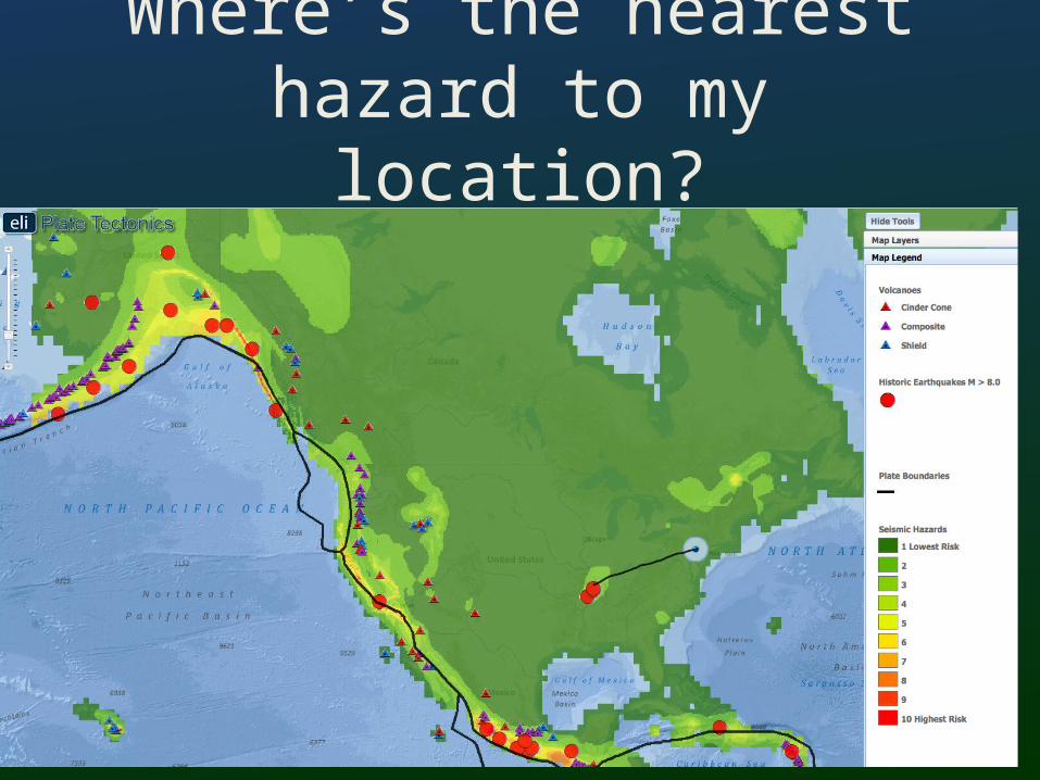
Where’s the nearest hazard to my location?

How do we recognize plate boundaries?

How does thermal energy move around in
the Earth?

Spatial patterns at a continental shelf

What happens when plate diverge?

What happened when plates move sideways past each
other?

Investigating the San Andreas Fault Zone

What happens when plates collide?

Prototype testing findings
High fidelity of implementation – adherence to the events in the instructional model
High student engagement
Ease of use for urban middle school teachers
Some server issues identified with map services that were resolved to handle large numbers of users

Questions and Comments
http://www.ei.lehigh.edu/eli/tectonics
To access assessments, use:
Login: eliteacherPassword: 87dja92