Embed Size (px)
Citation preview
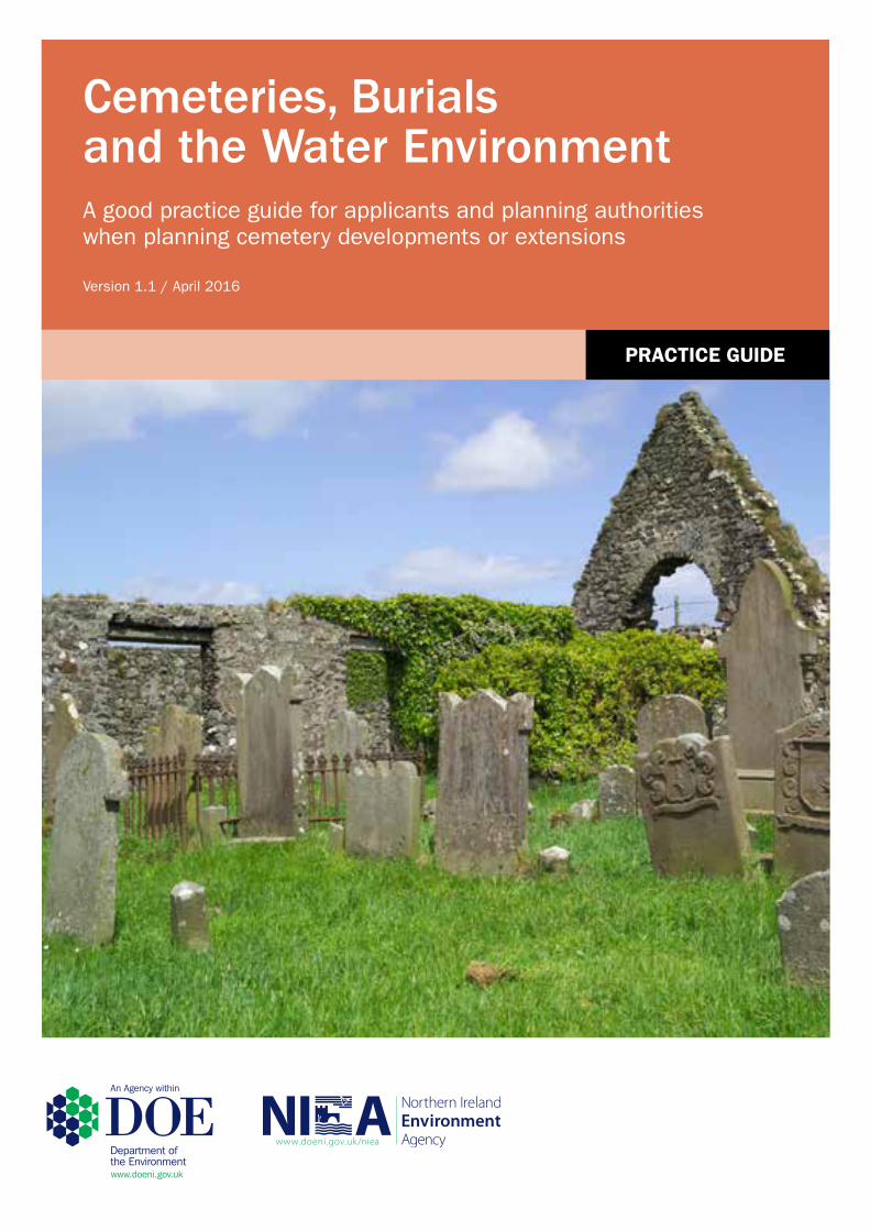
Cemeteries, Burials and the Water EnvironmentA good practice guide for applicants and planning authorities when planning cemetery developments or extensions
Version 1.1 / April 2016
prActIcE GuIDE
Practice Guide
1 | P a g e April 2016
This good practice guide aims to assist applicants and planning authorities achieve a consistent
approach when planning cemetery developments or cemetery extension. Its correct application
should help applicants and planning authorities identify and satisfy legislative requirements with
regard to groundwater protection in development projects.
This guide does not attempt to provide a detailed account of the legislation and policy that
underpin groundwater protection in Northern Ireland and is not intended to be a source of legal
advice. This guide is not intended to replace the need for judgement by planning officers and
those making planning applications. Reference should always be made to the relevant legislation
and if any discrepancy or conflict exists between the contents of this guide and the relevant
legislation, the provisions of the legislation will prevail.
Further information can be obtained from the NIEA website www.doeni.gov.uk. Links to external
sources of information have also been provided in the text, where appropriate.
Cemeteries, Burial and the Water Environment
April 2016 2 | P a g e
Contents
Overview 3
1 Why is it important to protect groundwater? 4
2 How can cemeteries contaminate groundwater? 4
3 What information does NIEA require before assessing if a cemetery
development/extension will pose a threat to groundwater? 4
4 Desktop study 5
5 Intrusive site investigation 5
6 Risk assessment 7
7 Guidelines for planning cemeteries 7
8 Checklist 8
9 References 9
10 Information sources 10
Practice Guide
3 | P a g e April 2016
Overview
The development of new cemetery sites/graveyards or extensions to such sites has the
potential to result in impact on the local water environment and in particular, the groundwater
underlying the site. It is important when planning such sites that consideration is given to
possible impacts and where appropriate, ensuring that adequate site investigation and risk
assessment is undertaken. The extent of site investigation and risk assessment should be
proportionate to the size of the proposed development.
This guidance document aims to help developers and their environmental consultants who
are responsible for the development of new cemetery sites/graveyards or extensions to such
sites. It is strongly recommended that the applicant seeks the professional advice of a
hydrogeologist. Hydrogeologists (not hydrologists) can be identified through internet search,
Yellow Pages or the Ends Directory (www.endsdirectory.com).
The guidance covers the main areas and issues to be considered when assessing the
potential impact on groundwater and provides details of the relevant information required to
enable NIEA to provide advice.

Cemeteries, Burial and the Water Environment
April 2016 4 | P a g e
1. Why is it important to protect groundwater?
1.1 Groundwater has three major uses in Northern Ireland:
private drinking water supply;
abstractions for agricultural and industrial purposes, including bottled ‘mineral’
waters and carbonated drinks; and
maintenance of flow and water levels in rivers, lakes and wetlands, particularly
during times of low rainfall.
1.2 The protection of groundwater from the risk of possible contamination is important
because pollutants could cause health problems in human beings, reduce the quality
of farming and agricultural products, make the water unsuitable for certain industrial
processes and pose a threat to our countryside and environment including their
suitability for recreational purposes. In summary, the contamination of groundwater
can not only have health and environmental impacts, but also serious economic
consequences.
2. How can cemeteries contaminate groundwater?
2.1 After a while in the ground a body and its coffin will begin to decay. As this happens
fluids can leach out and may eventually work their way down to the groundwater
underlying the site. This fluid may contain embalming fluid, pathogens/microbes and
nitrogen compounds which could contaminate groundwater. In some cases it may
also pose a health risk if it contaminates a groundwater-fed drinking water source
2.2 As groundwater can travel considerable distances underground (and with it any
pollutants) it is necessary to consider the possible risk of groundwater contamination
when planning new graveyards or cemeteries.
3. What information does NIEA require before
assessing if a cemetery development/extension will
pose a threat to groundwater?
3.1 NIEA will expect information on the following to be provided:
A desktop study;
An intrusive site investigation and water features survey;
Practice Guide
5 | P a g e April 2016
A hydrogeological risk assessment; and
The proposed layout of the site (this is the final stage as the above tasks will inform the site planning).
4. Desktop study
4.1 When considering use of land for burial purposes, it is normal practice for an initial
desktop assessment to be undertaken using information readily available from a
variety of sources (see section 10). This allows for initial consideration of the
potential issues and risks associated with the specific site based upon geological
setting, water quality, proposed burial rate per annum and total capacity of the
cemetery.
4.2 For existing sites, important local knowledge about the ground/ geological conditions
can be obtained through discussion with the local grave digger.
4.3 Based upon this initial consideration, the need for intrusive investigation can be
better assessed, taking into account the proposed scale and sensitivity of the site
location. Further information regarding this decision process can be found in
reference 4 and 5.
5. Intrusive site investigation
5.1 The site walkover should aim to identify any boreholes, watercourses and sensitive
targets in the proximity of the proposed site (see previous section) and determine
their distance from or position within the proposed site (please see the practice guide
‘Water Features Survey’ – reference 3). This will allow features to be mapped for
submission along with the report and accompanying planning application.
5.2 The absolute minimum requirement for a site investigation should normally consist of
a site walkover as described above and the digging of trial pits. The trial pits and any
observed water seepages or strikes are required to be logged according to British
Standard BS5930:2015. Logs should be appended to any planning application
together with a location map of the trial pits. If photographs of trial pits are submitted
they should include a visible tape measure confirming the depth of the pit.
5.3 The trial pits should be excavated to a depth of 1 metre below the intended depth
of the grave to assess the site and soil for its suitability as a burial site. The number
of trial pits will depend on the size of the site.
5.4 Other points for consideration include:
Are there any old, metal water mains passing beneath the cemetery whose corrosion could be accelerated?
Is there any artificial drainage within the ground, associated with previous/existing land use?

Cemeteries, Burial and the Water Environment
April 2016 6 | P a g e
5.5 For certain large scale and/ or sensitive sites there may be a need to undertake
further intrusive site investigation using borehole drilling, baseline sampling and other
assessment techniques.
5.6 Figure 1: Diagram to illustrate total investigation depth
Practice Guide
7 | P a g e April 2016
6. Hydrogeological risk assessment
6.1 The risk assessment will be based upon data and knowledge gained from the
desktop assessment and the intrusive site investigation. The scope of the risk
assessment required will be dependent on site specific factors such as intended
annual burial rate, the local vulnerability of groundwater and the scale of the site
proposed. Further guidance on risk assessment can be found in the ‘Pollution
Potential of Cemeteries – R&D Technical Report P223’ and its amendments
(references 4 to 6).
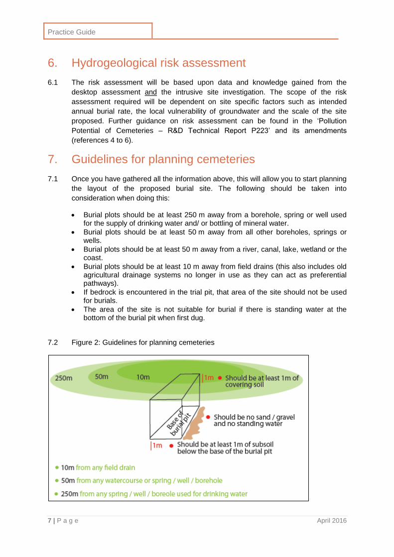
7. Guidelines for planning cemeteries
7.1 Once you have gathered all the information above, this will allow you to start planning
the layout of the proposed burial site. The following should be taken into
consideration when doing this:
Burial plots should be at least 250 m away from a borehole, spring or well used for the supply of drinking water and/ or bottling of mineral water.
Burial plots should be at least 50 m away from all other boreholes, springs or wells.
Burial plots should be at least 50 m away from a river, canal, lake, wetland or the coast.
Burial plots should be at least 10 m away from field drains (this also includes old agricultural drainage systems no longer in use as they can act as preferential pathways).
If bedrock is encountered in the trial pit, that area of the site should not be used for burials.
The area of the site is not suitable for burial if there is standing water at the bottom of the burial pit when first dug.
7.2 Figure 2: Guidelines for planning cemeteries
Cemeteries, Burial and the Water Environment
April 2016 8 | P a g e
7.3 The completed written report and accompanying site plan should be submitted to the
Planning Authority along with the planning application documentation. Please ensure
your submission includes everything mentioned in the checklist in the following
section.
8. Checklist
Component
Desktop study – information should include local geology (bedrock and
superficial), groundwater vulnerability rating, soil type, historical land use, locations
of nearby water features and drainage features, locations of nearby surface and
groundwater abstractions, locations of nearby wells/boreholes used as a drinking
water supply, locations of other sensitive receptors in the vicinity (like protected
sites). You must include the proposed burial rate per year and number of total
burials and an explanation of how you have arrived at this figure. It may also be
useful to include knowledge of the site geology by the local gravedigger.
Intrusive site investigation – include full description of geology in the trial pits/
boreholes with logs prepared according to British Standard BS5930:2015. Log
depth to bedrock and depth of any water strikes. A map showing location of trial
pits/ boreholes within the site should be included. The number of trial pits/
boreholes should be proportionate to the size of the proposed development.
Map of proposed site layout – this should only be undertaken after consideration
of all the information gathered above, in conjunction with recommended cemetery
planning guidelines mentioned in previous sections. Note: your site assessment
may mean that some areas of your site are unsuitable for graves and should
therefore be used for pathways/ car parks/ other features.
Practice Guide
9 | P a g e April 2016
9. References
Robin, N. S. (1996). Hydrogeology of Northern Ireland. London: HMSO for the British
Geological Survey.
The following guidance documents are available online:
1) Water Managment Unit. 2011. Planning Guidance note: cemeteries [Online] Northern
Ireland Environment Agency. Available at:
https://www.doeni.gov.uk/sites/default/files/publications/doe/water-guidance-planning-
guidance-note-cemeteries-2011.pdf [Accessed 4 February 2016]
2) DOE. 2015. Required Environmental Information DOE. Available online:
http://www.planningni.gov.uk/index/advice/northern_ireland_environment_agency_guida
nce/required_environmental_information.pdf [Accessed 4 February 2016]
3) DOE. 2015. Water Features Survey. DOE. Available online:
http://www.planningni.gov.uk/index/advice/northern_ireland_environment_agency_guida
nce/water_features_surveys.pdf [Accessed 4 February 2016]
4) Young, C.P., Blackmore, K.M., Reynolds, P. and Leavens, A. (2002). Pollution Potential
of Cemeteries – R&D report P223. Environment Agency England and Wales. Available
online:
https://www.gov.uk/government/uploads/system/uploads/attachment_data/file/290605/str
-p223-e-e.pdf [Accessed 4 February 2016]
5) Young, C.P., Blackmore, K.M., Reynolds, P. and Leavens, A. (2002). Amendment
‘Pollution Potential of Cemeteries’ – R&D report P223. Environment Agency England and
Wales. Available online:
https://www.gov.uk/government/uploads/system/uploads/attachment_data/file/290376/sc
ho0205biph-e-e.pdf [Accessed 4 February 2016]
6) Young, C.P., Blackmore, K.M., Leavens, A and Reynolds, P.J. (2002). Pollution Potential
of Cemeteries. Environment Agency England and Wales. Available online:
https://www.gov.uk/government/uploads/system/uploads/attachment_data/file/290607/sp
rp2-024-1-e-e.pdf [Accessed 4 February 2016] – literature review
7) Üçisik, A.S. and Rushbrook, P. (1998). The impact of cemeteries on the environment
and public health. World Health Organization Regional Office for Europe Available
online:
http://apps.who.int/iris/bitstream/10665/108132/1/EUR_ICP_EHNA_01_04_01(A).pdf
[Accessed 4 February 2016]
8) Buckley, C. (2012) Graveyards and Groundwater. International Association of
Hydrogeologists – Irish Group. Available online: http://www.iah-ireland.org/conference-
proceedings/2012.pdf. [Accessed 4 February 2016]- see pdf page 143
Cemeteries, Burial and the Water Environment
April 2016 10 | P a g e
9) Institute of Cemetery & Crematorium Managment. 2004 Policy relating to shallow depth
graves. London: Institute of Cemetery & Crematorium Management. Available online:
http://www.iccm-uk.com/iccm/library/ShallowGraves.pdf [Accessed 4 February 2016]
10) Hart, A. (2005). Ammonia shadow of my former self: a review of potential groundwater
chemical pollution from cemeteries. Land Contamination & Reclamation 13(3). Available
online: http://www.epppublications.com/home/land-contamination-reclamation/volume-13
10. Information sources
Geological Survey of Northern Ireland
Tel: 028 90388462
Website: www.bgs.ac.uk/gsni/
Email: [email protected]
GeoIndex, geological maps, reports and memoirs, borehole and site investigation reports
Northern Ireland Environment Agency
Water Management Unit
Tel: 028 92623100
Website: www.doeni.gov.uk
Email: [email protected] or [email protected] for abstraction licences
River Basin and Protected Areas viewers, surface water and groundwater information,
hydrogeological data
Ordnance Survey of Northern Ireland
Tel: 0300 200 7804
Website: www.nidirect.gov.uk/osni-mapping-helpdesk
http://www.nidirect.gov.uk/ordnance-survey-of-northern-ireland
Topographical information, historical maps
SpatialNI
Website: www.spatialni.gov.uk/geoportal/catalog/main/home.page
Historical land use database
Rivers Agency
Website: www.dardni.gov.uk/topics/rivers-and-flooding.htm
Flow data, flood risk areas

NIEA Natural Heritage Division Klondyke BuildingGasworks Business ParkCromac AvenueOrmeau RoadMalone LowerBelfastBT7 2JA
T: 028 9056 9604E: [email protected]