Embed Size (px)
Citation preview

Authored by the City of Duluth, Department of Planning
& Development with acknowledgement and
appreciation to the residents of the Hill Community.
February 2012
A Guide for Development, Future
Infrastructure and Community Services
within the Hill Community Neighborhood.
Page | 2 February 2012
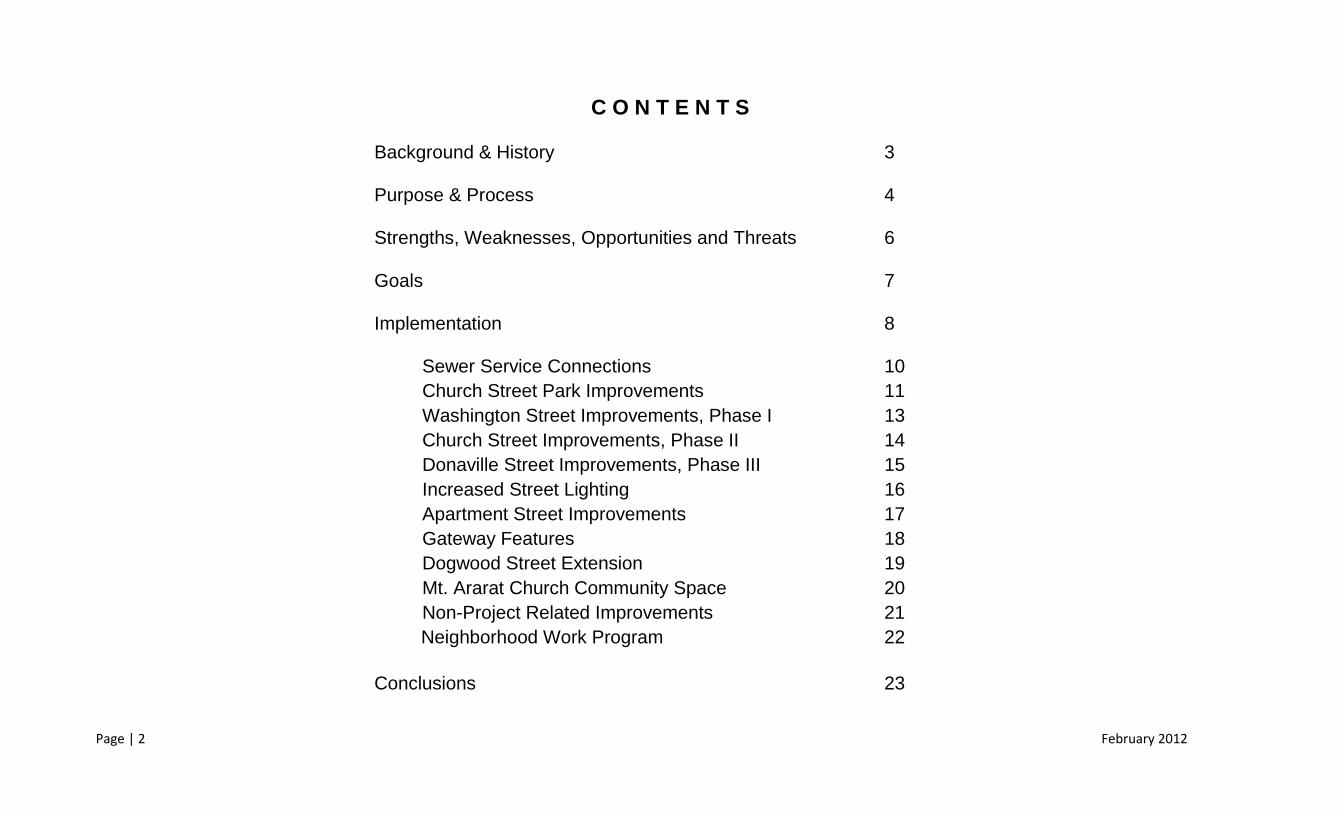
C O N T E N T S
Background & History 3
Purpose & Process 4
Strengths, Weaknesses, Opportunities and Threats 6
Goals 7
Implementation 8
Sewer Service Connections
Church Street Park Improvements
10
11
Washington Street Improvements, Phase I 13
Church Street Improvements, Phase II 14
Donaville Street Improvements, Phase III 15
Increased Street Lighting 16
Apartment Street Improvements 17
Gateway Features 18
Dogwood Street Extension 19
Mt. Ararat Church Community Space
Non-Project Related Improvements
20
21
Neighborhood Work Program 22
Conclusions 23

Page | 3 February 2012
BACKGROUND & HISTORY
The Neighborhood
The area known as the Hill Community is an established mostly residential neighborhood with some structures
dating back to as far as 1878. Located near the heart of downtown Duluth and on Buford Highway it has been
a long standing integral part of the City of Duluth for generations. When previous capital improvement plans
were made in the area and when it was defined by the Duluth 2030 Character Area component, the
neighborhood boundaries were established to along the outer edge of and contain all parcels fronting certain
streets. These streets are Church Street, Washington Street, Donaville Street, Dogwood Street, Jones Street
and Apartment Drive. Beyond the described properties, certain properties bordering the stated streets yet
fronting Buford Highway are also included in the neighborhood.
The Hill Community is made up of 54 housing units that are 46% owner occupied. The average age of all
structures in the neighborhood is 40.5 years. That number is somewhat skewed by the presence of two
historical structures (Mt. Ararat Church and the Strickland House) that pre-date the majority of neighborhood structures by a significant amount. The average
household size in the neighborhood is 2.55 persons with an average time at residence of 29.2 years.
Background
The Hill Community has many capital improvement projects either completed or proposed. These include the Church Street drainage, road and sidewalk project
completed in 2008 and similar proposed improvements for Dogwood, Donaville, and Jones Streets. These projects will provide safer sidewalks for pedestrian use
and wider roads to help vehicular flow and improve safety. The proximity of the neighborhood means it is included in many of the long range plans Duluth has for
its city. It is a part of the Buford Highway Corridor study, the Duluth 2030 plan, the Parks Master Plan, and the Livable Centers Initiative (LCI) study. Sample
projects under consideration include a newly renovated and improved Church Street Park and the extension of Dogwood Street that would connect the
neighborhood to Duluth Highway (Hwy. 120) as specified in the 2011 Update to the LCI Plan.

Page | 4 February 2012
PURPOSE & PROCESS
Purpose
The purpose of this document is to establish a plan upon which the community will
grow, develop and improve in the coming years. The plan establishes a boundary for
the neighborhood and illustrates its history. The plan also describes the character of
the neighborhood through demographics, public opinion and qualitative factors. The
document then sets forth goals that have been identified by the residents and
stakeholders of the neighborhood. The intent of the planning process is for a set of
projects and other initiatives to be developed that might further the goals identified
within the plan.
Three (3) public meetings were held in the neighborhood during 2011, on May 26,
August 18 and November 3. The first two meetings were a combination of information
presentation and public workshops. The final meeting in November was a presentation
of this plan document.
Relationship to Comprehensive Plan
The Community Agenda of the Duluth 2030 Comprehensive Plan sets forth a guide for
the future development and redevelopment of and in the City of Duluth over a long
range planning horizon of twenty (20) years. As a part of this guide, the document
describes certain character areas that are meant to define distinct areas of the city and
aid in the implementation of the citywide vision that was established as a part of the
comprehensive plan community visioning process. During this process, the City was
divided into different areas by the land development patterns that had occurred and
were likely to occur in each area. These areas are known as Character Areas in the
Comprehensive Plan.
The Hill Community Neighborhood is identified in this document as being one of the
City’s Targeted Community Development Character Areas. This character area is
defined as corresponding with Duluth’s originally settled residential blocks outside of
the historic town center. The residential nature and established infrastructure patterns
make the Targeted Community Development Character Areas prime for Neighborhood
Planning efforts.
Page | 5 February 2012
PURPOSE & PROCESS
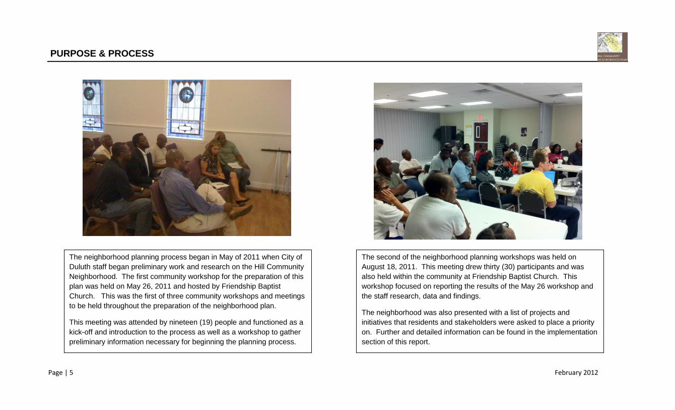
The neighborhood planning process began in May of 2011 when City of
Duluth staff began preliminary work and research on the Hill Community
Neighborhood. The first community workshop for the preparation of this
plan was held on May 26, 2011 and hosted by Friendship Baptist
Church. This was the first of three community workshops and meetings
to be held throughout the preparation of the neighborhood plan.
This meeting was attended by nineteen (19) people and functioned as a
kick-off and introduction to the process as well as a workshop to gather
preliminary information necessary for beginning the planning process.
The second of the neighborhood planning workshops was held on
August 18, 2011. This meeting drew thirty (30) participants and was
also held within the community at Friendship Baptist Church. This
workshop focused on reporting the results of the May 26 workshop and
the staff research, data and findings.
The neighborhood was also presented with a list of projects and
initiatives that residents and stakeholders were asked to place a priority
on. Further and detailed information can be found in the implementation
section of this report.

Page | 6 February 2012
STRENGTHS, WEAKNESSES, OPPORTUNITIES & THREATS
A common tool to assist in guiding communities through the identification of the
unique features and elements and problems facing the area is a SWOT analysis.
A SWOT analysis defines a community’s Strengths, Weaknesses, Opportunities
and Threats so that goals for action may be drafted. This tool was used with
great success at the first public workshop held in May 2011. The results of this
community analysis are shown in Figure 1.
STRENGTHS
Stability
Churches
Church Street Park
Location of Neighborhood
History
Active Neighbors who Know Each Other
WEAKNESSES
Lack of Sewer Service
Perception (Internal & External)
Poor Transportation Infrastructure
Poor Access From Major Roads
Lack of Sufficient Public Lighting
Insufficient/Ineffective Stormwater Infrastructure
OPPORTUNTIES
Church Street Park (Opportunity to Upgrade)
New/Infill Housing
Introduction of Sewer Service
Outreach of Churches
Grant Funds
History / Mr. Ararat Church Site
THREATS
Vacant & Substandard Buildings
Lack of Connectivity
Drug Activity
Lack of Sewer Service
Condition of Infrastructure
Figure 1, Results of SWAT analysis.

Page | 7 February 2012
GOALS
At the workshop meeting held on May 26, 2011, the community members
and stakeholders who were present were asked to record the
neighborhood’s strengths, weaknesses, opportunities and threats. The
purpose of this activity was to create an inventory of issues and assets that
the participants could then use to create a master list of overall goals for the
community.
The group of participants was split into two small working groups. Each
group was given the task of formulating a list of goals for the neighborhood.
The lists of goals that were obtained were consolidated into a master list of
identified goals for the Hill Area Neighborhood. That list is shown in Figure
2.
GOALS (UNRANKED)
Improve and Create New Major Road
Connections
Create Wider Roads with Improved Surfacing
Connect the Neighborhood to Sewer Service
Improve Street Lighting in the Neighborhood
Install More Sidewalks
Improve Stormwater Infrastructure
Increase Police Presence in the Neighborhood
Create New and Improve Existing Parks &
Public Space
Improve the Quality of Life and Housing in the
Neighborhood
Create an Entryway / Gateway Feature
Figure 2, Unranked, Consolidated List of Goals.

Page | 8 February 2012
IMPLEMENTATION
Goal Implementation
Improve and Create New Major Road Connections
Dogwood Street Extension (From 10-Year LCI Update)
Create Wider Roads with Improved Surfacing Church St Phase II Improvements Washington Street Improvements Donaville Street Phase III Improvements Apartment Drive Improvements
Connect the Neighborhood to Sewer Service Install and Connect Sewer in the Hill Area
Improve Street Lighting in the Neighborhood Donvaille Street Lighting Additions/Improvements
Washington Street Lighting Additions/Improvements
Install More Sidewalks Church St Phase II Improvements Washington Street Improvements Donaville Street Phase III Improvements Apartment Drive Improvements
Improve Stormwater Infrastructure Church St Phase II Improvements Washington Street Improvements Donaville Street Phase III Improvements Apartment Drive Improvements
Increase Police Presence in the Neighborhood Identify and Increase Patrols for Issue Areas
Create New and Improve Exiting Parks and Public Facilities
Church Street Park Master Plan Implementation
Creation of Community Space at Mt. Ararat Site
Improve the Quality of Life and Housing the Neighborhood
Individual, project level CDBG Grants.
Create an Entryway Feature Church Street Entryway Donaville Street Entryway Jones Street Entryway Dogwood Street Entryway
The next step in the planning process was to develop strategies for
implementation of the community’s goals. Of the ten (10) goals drafted by
the community, it was determined that eight (8) of these goals could be
addressed through capital projects and two (2) of the goals implemented
through City initiatives.
A project list was created and the community was engaged in a visual
preference activity during the second public workshop held on August 18,
2011. The community was presented with a project preference map on
which each participant placed three green dots on his or her highest priority
projects. The community was also presented with a second map, the
Target Assistance Areas map. Each participant was given two blue and two
yellow dots with the instructions to place each blue dot on the area of the
neighborhood perceived to be most in need of police assistance and to
place each yellow dot on the area of the neighborhood where he or she had
observed the most significant stormwater drainage issues.
The list of implementation projects is shown in Figure 3. Figure 4, on the
following page, shows the ranked listing of goals obtained from the project
preference map activity. Figure 5, also on the next page, shows the results
of the Target Assistance Areas map activity.
Figure 3, Implementation Projects linked with Goals.

Page | 9 February 2012
IMPLEMENTATION
Project Votes Rank
Church Street Park Improvements 15 1
Washington Street Phase I 10 T2
Washington Street Phase II 10 T2
Church Street Phase II 7 T4
Donaville Street Phase III 7 T4
Increased Street Lighting 4 6
Apartment Street 3 T7
Gateway Features 3 T7
Dogwood Street Extension 2 9
Sewer Service Connections 1 10
Mt. Ararat Community Space 0 11
Figure 5, Target Assistance Areas Activity Results
Figure 4, Ranked Implementation Projects (By Vote Results)

Page | 10 February 2012
IMPLEMENTATION | 1 Sewer Service Connections
Since the first neighborhood meeting in this planning process, sewer
connections for the neighborhood have come up quite often in all types
of elements ranging from weaknesses to opportunities.
Even though the goal and related implementation project did not score
as a high priority during voting at the August workshop, the
overwhelming opinion of the residents present at the November
community meeting was that the installation of sewer service was the
most important goal to the vitality of the community. Therefore, this
goal is to be given top priority and future eligible funds that are
available to the neighborhood should be directed toward its
implementation.
This goal was presented at the second community workshop along with
financial data regarding the cost to the City and the cost to each
property owner within the neighborhood who would be connected to the
Gwinnett County Sewer System. Based upon the neighborhood’s
interest, the City approached the Gwinnett County Department of Water
Resources (GDWR) regarding feasibility and the cost of sewer
installation. The total cost to design and install sewer for the 28
properties identified by GDWR was quoted at $1,816,587.49. Of this
amount, 2/3 ($1,211,058.32) would be paid by the GDWR and 1/3
($605,529.16) would be the responsibility of the City of Duluth. In
addition, there is a connection fee of roughly $4,200 that would be
assessed to each property owner. The connection fee can be
repayable over 10 years at 5% interest and added to each water/sewer
bill. This would come out to roughly a $45 / month expense to each
property owner in the neighborhood. In addition, 70% of the property
owners within the potential service are must sign a petition for service.
Figure 6, Existing Water (Blue) & Sewer (Orange) Lines in
the Area

Page | 11 February 2012
IMPLEMENTATION | 2 Church Street Park Improvements
Figure 7 above shows the current facilities in the Church Street
Park. Residents cited the need for plumbing (bathrooms, water
fountain), better maintenance and more picnic/pavilions facilities.
While the Church Street Park received the largest number of
votes during the initial project preference activity, after sanitary
sewer service was established as the top priority, the park is now
the second highest priority project for the neighborhood. Park
improvements are generally funded through SPLOST allocations.
Figure 8 above is a graphic excerpt from the City’s 2007 Parks
Master Plan. It became apparent during the community
workshops held with the neighborhood that this plan may not
reflect the current needs and desires of the neighborhood. In
order to implement park improvements, the neighborhood should,
under city guidance, form a Park Improvement Committee to work
with the City’s Parks and Recreation Board toward creating an
updated, detailed park plan for Church Street Park.
Figure 7, Church Street Park Existing Conditions Figure 8, Church Street Park Master Plan

Page | 12 February 2012
IMPLEMENTATION | Street Improvements
One of the neighborhood’s greatest problem areas has long been
rooted in the transportation network that is present. Of the streets
serving the Hill Community, none are entirely up to modern day
transportation design standards. Portions of Church Street and
Washington Street have been improved by the City and funded by
Community Development Block Grant (CDBG) Funds. Further street
improvements are currently in the design phase and slated for
construction in 2012. The list below shows the streets in the Hill
Community and their improvement status:
Improvements Completed Church Street (Buford Highway to Washington) Washington Street (Partial)
Improvements in Design / 2012 Construction
Donaville Street (Buford Highway to Apartment Drive) Jones Street Dogwood Street
Improvements Identified in this Plan
Washington Street (Remainder) Donaville Street (Apartment Drive to Washington Street) Apartment Drive
All completed and planned street improvements call for standardizing
the street widths and surfacing, installation of sidewalks and
improvement of the stormwater drainage system. Figure 9 provides an
overview of street improvements in the Hill Community Neighborhood.
Figure 9, Street Improvement Projects Overview

Page | 13 February 2012
IMPLEMENTATION | 3 Washington Street Improvements
Washington Street runs from its intersection with Church Street
southeast to a point where it terminates as a dead-end street.
Washington Street serves predominantly residential land uses but also
serves as major frontage and an access point for Friendship Baptist
Church.
The Washington Street Improvements project scored very highly during
the project preference workshop activity. As the aerial image on this
page shows, (Figure 10) much of the street’s surfacing and sidewalks
have been improved through a combination of work done under CDBG
funded improvement projects and development activity at Friendship
Baptist Church. As Figure 9 (on the previous page) shows, the
Washington Street project is divided into two phases. Much of Phase I
has been completed from a surfacing and pedestrian mobility
standpoint, but further analysis of the stormwater drainage situation on
this phase must now be conducted.
When correlated with the results of the Target Assistance Areas activity
(refer to pages 8-9), it appears that the stormwater management along
Phase I of this project may be the primary cause for the high score and
desired high priority on the pursuance of this project. It should be
noted that Friendship Baptist Church is currently in the process of
obtaining permits to expand the existing church facilities along
Washington Street. Inherent in this permitting process will be the
addition of new stormwater detention and improvement of existing
facilities. This will be taken into consideration when analyzing
stormwater infrastructure in the area. Phase II of the project has not
been designed or funded, but the neighborhood has placed a high
priority on this project. Further work on this project may be funded
through CDBG applications and continue the work begun with Church
Street and ongoing with Donaville, Jones and Dogwood Streets.
Figure 10, Washington Street Figure 11, Washington Street, Improvement Plan

Page | 14 February 2012
IMPLEMENTATION | 4 Church Street Improvements
Church Street runs from its intersection with Buford Highway southeast
to a point where it terminates as a dead-end street. Church Street
serves predominantly residential land uses but also serves as major
frontage and an access point for Mr. Carmel and Friendship Baptist
Churches as well as the Church Street Park.
The Church Street Phase II Improvement project received the same
score as the Donaville Street Phase III improvement on the project
preference activity. As the aerial image in Figure 13 shows, much of
the street’s surfacing and sidewalks have been improved through a
combination of work done under CDBG funded improvement projects
and development activity at Friendship Baptist Church. Phase one of
the Church Street Improvement project was completed in 2009 and
added sidewalks, proper surfacing and improved stormwater facilities to
the street. Further work on this project may be funded through future
CDBG applications and would continue the work begun with Church
Street and ongoing with Donaville, Jones and Dogwood Streets.
Figure 12, Church Street, Phase II
Figure 13, Church Street, Phase II

Page | 15 February 2012
IMPLEMENTATION | 5 Donaville Street Improvements
Donaville Street runs from its intersection with Buford Highway
southeast and then west to a point where it intersects Washington
Street. Donaville Street serves predominantly residential land uses but
also serves as major frontage and an access point for Friendship
Baptist Church.
Phases I and II of the Donaville Street Project are currently financed for construction through the Community Development Block Grant program. These two phases, which run from Buford Highway to Apartment Drive collectively, are in the design phase and are to begin construction in 6-8 months. Phase III of Donaville Street shown in Figure 14, is the phase being identified by this goal and implementation project. Further work on this project may be funded through future CDBG applications and would continue the work begun with Church Street and ongoing with Donaville, Jones and Dogwood Streets
Figure 14, Donaville Street, Phase III
Figure 15, Donaville Street, Phase III

Page | 16 February 2012
IMPLEMENTATION | 6 Increased Street Lighting
During the initial public workshop, a lack of sufficient public lighting was
identified as a weakness of the area. Subsequently, improved street
lighting was formulated as a goal and implementation project. Through
further study of the lighting conditions of the area, key areas lacking
sufficient lighting were identified along Donaville Street and Washington
Street. A map of all street lighting fixtures can be seen in Figure 16.
The Washington Street area receives a substantial amount of
supplemental lighting from the fronting Friendship Baptist Church and
its associated parking areas. City staff met with representatives from
Georgia Power to discuss current lighting and opportunities for
improvement. It was determined that the area most devoid of public
lighting (Donaville Street, Buford Highway to Dogwood Street) can and
will be improved in conjunction with the Donaville Street improvement
project that is to begin construction in spring of 2012.
Figure 16, Street Lighting Fixtures in the Neighborhood

Page | 17 February 2012
IMPLEMENTATION | 7 Apartment Drive Improvements
Apartment Drive runs from its intersection with Donaville Street
southwest to its terminus. The road currently serves two residences.
It is planned that some intersection improvements will benefit
Apartment Drive when they are installed as a part of the Donaville
Street project, Phases I and II.
Further work on this project, including surfacing and stormwater
analysis and/or improvement may be funded through future CDBG
applications to continue the work begun with Church Street and
ongoing with Donaville, Jones and Dogwood Streets
Figure 17, Apartment Drive, Street Improvement Plan
Figure 18, Apartment Drive, Aerial View

Page | 18 February 2012
IMPLEMENTATION | 8 Gateway Features
Gateway features ranging from identifying signage to unique
landscaping installations could enhance the community and further
promote the sense of continuity in the area. When this implementation
project was presented to the community, it was shown as an installation
at community entrances (as shown in figure 20):
Church Street & Buford Highway
Donaville Street & Buford Highway
Jones Street & Buford Highway
Dogwood Extension & Neighborhood Boundary
This project received three (3) votes during the project preference
activity. Therefore, the project is ranked eighth among all
implementation projects. However, the installation of gateway features
could be done incrementally or only at some suggested locations and
at a much lower cost than some of the more highly ranked projects.
Based upon this, it is recommended to explore the installation of said
features when funding becomes available.
Figure 20, Proposed Gateway Feature Locations
Figure 19, Examples of Gateway Features
Page | 19 February 2012
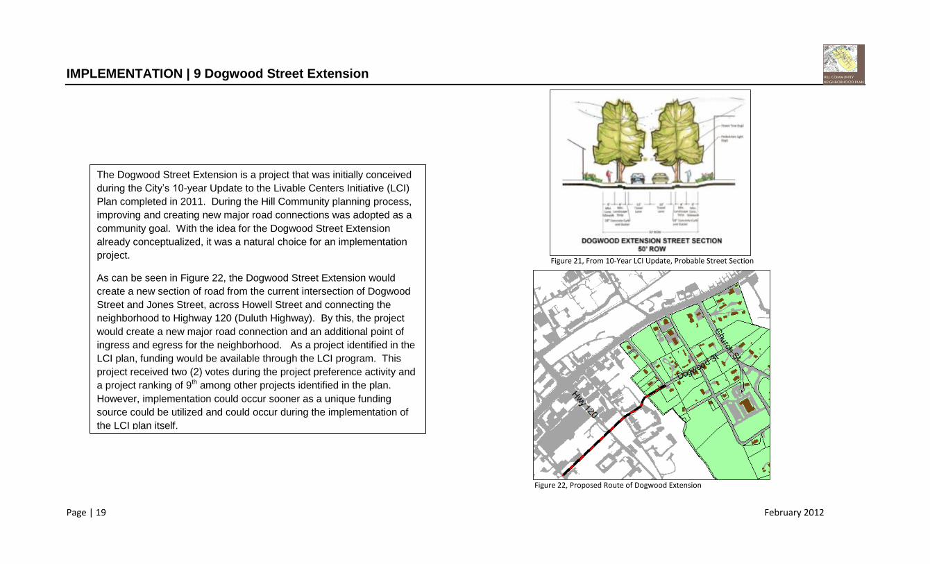
IMPLEMENTATION | 9 Dogwood Street Extension
The Dogwood Street Extension is a project that was initially conceived
during the City’s 10-year Update to the Livable Centers Initiative (LCI)
Plan completed in 2011. During the Hill Community planning process,
improving and creating new major road connections was adopted as a
community goal. With the idea for the Dogwood Street Extension
already conceptualized, it was a natural choice for an implementation
project.
As can be seen in Figure 22, the Dogwood Street Extension would
create a new section of road from the current intersection of Dogwood
Street and Jones Street, across Howell Street and connecting the
neighborhood to Highway 120 (Duluth Highway). By this, the project
would create a new major road connection and an additional point of
ingress and egress for the neighborhood. As a project identified in the
LCI plan, funding would be available through the LCI program. This
project received two (2) votes during the project preference activity and
a project ranking of 9th among other projects identified in the plan.
However, implementation could occur sooner as a unique funding
source could be utilized and could occur during the implementation of
the LCI plan itself.
Figure 21, From 10-Year LCI Update, Probable Street Section
Figure 22, Proposed Route of Dogwood Extension

Page | 20 February 2012
IMPLEMENTATION | 10 Mt. Ararat Community Space
Figure 23, Mt. Ararat Church Building
Figure 24, Conceptual Site Plan, Mt. Ararat Community Space
Mt. Ararat Church is the oldest building within the neighborhood. The
1,664 square foot church building was constructed in 1878 and is no
longer in active use. The structure represents an important historical
element to the neighborhood. During the planning process, it was
discovered that community members care for the lot, maintain a garden
on site and often use the site for gatherings.
Based upon the current utilization and the historical and social
importance of the site, it was thought that the exploration of
implementing this site as a an additional community space for the
neighborhood would be an effective way to implement the Create New
and Improve Exiting Parks and Public Facilities goal. The site is
privately owned and any such effort would require city or community
ownership. This implementation project idea received no votes during
the project preference activity but remains in the plan as the 10th ranked
implementation goal.

Page | 21 February 2012
IMPLEMENTATION | Non-Project Related Improvements
Figure 25, Target Assistance Areas-Results
Two (2) goals were formulated throughout this planning process that
were recognized as important but are not tied to any single
implementation project. Both of those goals were realized as a result of
the Target Assistance Areas activity (Figure 25) conducted at the
August community workshop. The goals are as follows:
Increase Police Presence in the Neighborhood
The concentration of blue dots shown in Figure 25 gives a clear
illustration of where the neighborhood feels that an increased police
presence is necessary. City of Duluth Planning Staff will advise the
Police Department to increase patrols to the end of Church Street.
Improve Stormwater Infrastructure
The yellow dots shown in Figure 25 illustrate where the residents of the
neighborhood perceive stormwater issues. Most of these are tied to in
progress or planned street improvement projects. When these projects
are completed, the stormwater conditions will be improved. The
concentration of yellow dots along Washington Street will be improved
as the Friendship Baptist Church completes the implementation of its
master plan, which includes improved stormwater facilities.

Page | 22 February 2012
IMPLEMENTATION | Neighborhood Work Program
Description Implementation Time Frame Possible Funding Sources
Sewer Service Connections Short Term CDBG, General Fund, County Financial Assistance
Church Street Park Improvements 2012 (Committee & Planning) SPLOST, CDBG
Washington Street Improvements 2013-2014 CDBG, SPLOST
Church Street Phase II Improvements 2015-2016 CDBG, SPLOST
Donaville Street Phase III Improvements 2017-2018 CDBG, SPLOST
Increased Street Lighting 2012 CDBG, General Fund
Apartment Drive Improvements 2019-2020 CDBG, SPLOST
Gateway Features Long Term Not Yet Identified
Dogwood Street Extension Long Term LCI, SPLOST
Mt. Ararat Community Space Long Term Not Yet Identified

Page | 23 February 2012
CONCLUSIONS
Summary
In conclusion, the Hill Community is a viable and culture-rich neighborhood within the vibrant City of Duluth. The neighborhood is a unique community composed of long-time
residents who have a great stake in the future of the Hill. Many of the goals established in this plan are aimed at adding a level of vibrancy to the study area as can be seen in
many other areas of the City. Several of the goals established in this plan focus on promoting the economic well-being of the neighborhood while others aim to provide a level of
infrastructure and safety that will aid the residents and further establish the Hill Community as an integral part of the City of Duluth. In order to do so, steps must be taken to
begin the implementation of this plan.
Next Steps
The Neighborhood Work Program found on page 22 of this report serves as a road map for what will be done and generally when it will be done. Moving forward, the next logical
steps in the neighborhood planning process would begin with intensive investigation into different routes of funding that may aid in the installation of sewer in the neighborhood.
Realization of this goal will require a level of coordination between the City of Duluth and Gwinnett County in order to clarify all costs involved and all options currently available.
In addition, a Church Street Park committee has been proposed. At least one member of the community is already scheduled to meet with the City’s Parks & Recreation
Department to begin a dialogue about the appropriate development of Church Street Park. It is also recommended that the City of Duluth planning staff and the residents and
stakeholders of the Hill Community engage in a plan update meeting at least annually to report on implementation. With the above mentioned next steps and the currently in-
progress road, sidewalk and drainage improvements, it is clear that steps are already being taken to implement some elements of this plan. As time progresses and more
implementation steps are taken, the partnership of the residents of the Hill Community and the City of Duluth can improve the neighborhood and ensure its viability for years to
come.