Embed Size (px)
Citation preview
Portland State University Portland State University
PDXScholar PDXScholar
Dissertations and Theses Dissertations and Theses
Summer 1-1-2012
A Historical and Archaeological Study of the A Historical and Archaeological Study of the
Nineteenth Century Hudson's Bay Company Garden Nineteenth Century Hudson's Bay Company Garden
at Fort Vancouver: Focusing on Archaeological Field at Fort Vancouver: Focusing on Archaeological Field
Methods and Microbotanical Analysis Methods and Microbotanical Analysis
Elaine C. Dorset Portland State University
Follow this and additional works at: https://pdxscholar.library.pdx.edu/open_access_etds
Part of the Biological and Physical Anthropology Commons, Inequality and Stratification Commons,
and the Social and Cultural Anthropology Commons
Let us know how access to this document benefits you.
Recommended Citation Recommended Citation Dorset, Elaine C., "A Historical and Archaeological Study of the Nineteenth Century Hudson's Bay Company Garden at Fort Vancouver: Focusing on Archaeological Field Methods and Microbotanical Analysis" (2012). Dissertations and Theses. Paper 869. https://doi.org/10.15760/etd.869
This Thesis is brought to you for free and open access. It has been accepted for inclusion in Dissertations and Theses by an authorized administrator of PDXScholar. Please contact us if we can make this document more accessible: [email protected].

A Historical and Archaeological Study of the Nineteenth Century
Hudson’s Bay Company Garden at Fort Vancouver:
Focusing on Archaeological Field Methods and Microbotanical Analysis
by
Elaine C. Dorset
A thesis submitted in partial fulfillment of the requirements for the degree of
Master of Artsin
Anthropology
Thesis Committee:Kenneth M. Ames, Chair
Douglas C. WilsonVirginia L. Butler
Portland State University©2012

ABSTRACT
The Hudson’s Bay Company (HBC), a British fur-trading enterprise, created a large
garden at Fort Vancouver, now in southwest Washington, in the early- to mid-19th century.
This fort was the administrative headquarters for the HBC’s activities in western North
America. Archaeological investigations were conducted at this site in 2005 and 2006 in
order to better understand the role of this large space, which seems incongruous in terms of
resources required, to the profit motive of the HBC.
Questions about the landscape characteristics, and comments by 19th century
visitors to the site provided the impetus for theoretical research of gardens as representations
of societal power, and, on a mid-range level, the efficacy of certain archaeological methods
in researching this type of space. Documentary research related to the history of the HBC
Garden was also conducted, including previous archaeology completed at the site. The
results of these lines of inquiry are presented, providing insight as to the diverse roles this
Garden fulfilled in the survival of the HBC in the region – as a commercial enterprise, as a
microcosm of western societal practice, and in the health of its employees.
i

DEDICATION
For my husband, family and friends
who were ever patient and supportive.
ii

ACKNOWLEDGEMENTS
This project was completed with the support of the Portland State University
Department of Anthropology staff and faculty, the National Park Service,
the Northwest Cultural Resources Institute, the North Coast and Cascades Science
Learning Network, and the Oregon Archaeological Society.
Special thanks to my fellow employees, field school students, and volunteers at
Fort Vancouver National Historic Site, my thesis advisor Douglas Wilson and
committee members Ken Ames and Virginia Butler.
iii

TABLE OF CONTENTS
ABSTRACT . . . . . . . . . . . . . . . . . . . . . . . . . . . . . . . . . . . . . . . . . . . . . . . . . . . . . . . . . . . . i
DEDICATION . . . . . . . . . . . . . . . . . . . . . . . . . . . . . . . . . . . . . . . . . . . . . . . . . . . . . . . . . . ii
ACKNOWLEDGEMENTS . . . . . . . . . . . . . . . . . . . . . . . . . . . . . . . . . . . . . . . . . . . . . . . iii
LIST OF TABLES . . . . . . . . . . . . . . . . . . . . . . . . . . . . . . . . . . . . . . . . . . . . . . . . . . . . . . . v
LIST OF FIGURES . . . . . . . . . . . . . . . . . . . . . . . . . . . . . . . . . . . . . . . . . . . . . . . . . . . . . vi
CHAPTER 1. Introduction and Background . . . . . . . . . . . . . . . . . . . . . . . . . . . . . . . . . . . 1
CHAPTER 2. Methods and Results of Archival Research . . . . . . . . . . . . . . . . . . . . . . . 10
CHAPTER 3. Summary of Research, Article and Publication Review Relating to Garden Archaeology Projects and Methods . . . . . . . . . . . . . . . . . . . . . . . 31
CHAPTER 4. Previous Archaeology at the Site of the Hudson’s Bay Company Garden at Fort Vancouver . . . . . . . . . . . . . . . . . . . . . . . . . . . . . . . . . . . . . 35
CHAPTER 5. Archaeological Research Design and Methods for the Fort Vancouver Garden Project . . . . . . . . . . . . . . . . . . . . . . . . . . . . . . . . . . . . . . . . . . . . . 43
CHAPTER 6. Archaeological Testing Results. . . . . . . . . . . . . . . . . . . . . . . . . . . . . . . . . 52
CHAPTER 7. Artifacts and Archaeobotanical Remains . . . . . . . . . . . . . . . . . . . . . . . . . 60
CHAPTER 8. Discussion. . . . . . . . . . . . . . . . . . . . . . . . . . . . . . . . . . . . . . . . . . . . . . . . . 85
CHAPTER 9. Conclusions and Recommendations . . . . . . . . . . . . . . . . . . . . . . . . . . . . 106
SOURCES CITED . . . . . . . . . . . . . . . . . . . . . . . . . . . . . . . . . . . . . . . . . . . . . . . . . . . . . 111
APPENDIX A: A Review of Research, Articles and Publications Relating to Garden Archaeology Projects and Methods . . . . . . . . . . . . . . . . . . . . . 123
APPENDIX B: Results of Excavations by Unit . . . . . . . . . . . . . . . . . . . . . . . . . . . . . . 144
APPENDIX C: WWI and Later Features Found at TA1 . . . . . . . . . . . . . . . . . . . . . . . 148
APPENDIX D: Phytolith Analysis of Samples from Fort Vancouver National Historic Site, Washington . . . . . . . . . . . . . . . . . . . . . . . . . . . . . . . . . . 152
APPENDIX E: Pollen and Phytolith Analysis of a Historic Garden at FortVancouver National Historic Site, Vancouver, Washington. . . . . . . . . 161
APPENDIX F: An Analysis of Pollen from Fort Vancouver Washington . . . . . . . . . . . 177
APPENDIX G: A Pollen Analysis of a Hudson’s Bay Company Non-GardenProvenience, Fort Vancouver, Washington . . . . . . . . . . . . . . . . . . . . . 235
APPENDIX H: Macrobotanical Analysis of Hand-picked and WetscreenSamples from Fort Vancouver, Washington . . . . . . . . . . . . . . . . . . . . . 280
iv

LIST OF TABLES
Table 1. HBC Features . . . . . . . . . . . . . . . . . . . . . . . . . . . . . . . . . . . . . . . . . . . . . . . . . . . . . . . . . 55
Table 2. HBC Garden and Village Artifact Count Comparison (artifacts per m3) . . . . . . . . . . . . 63
Table 3. Primary modes of flat glass thickness and corresponding thickness . . . . . . . . . . . . . . . 69
Table 4. HBC Artifacts by Functional Classification . . . . . . . . . . . . . . . . . . . . . . . . . . . . . . . . . . 73
Table 5. Introduced plants not previously known to have been grown at Fort Vancouver from historical documents, based on pollen analysis of Garden excavation sediments . . . . . . . . . . . . . . . . . . . . . . . . . . . . . . . . . . . . . . . . . . . . . . . . . . . 75
Table 6. Native plants with economic uses growing in the garden, or nearby . . . . . . . . . . . . . . . 76
v

LIST OF FIGURES
Figure 1. Looking northwest from the site of the WWI spruce mill at temporary housing
on the HBC Garden site...................................................................................................8
Figure 2. Detail of 1844 Line of Fire map with author’s annotations............................................11
Figure 3. Painting attributed to John Mix Stanley, ca. 1845 ..........................................................13
Figure 4. 1854 illustration by Gustavus Sohon ..............................................................................14
Figure 5. 1855 Covington sketch....................................................................................................15
Figure 6. Circa 1855 Hodges sketch (detail) ....................................................................................16
Figure 7. Stockade 1829-1834-36 ....................................................................................................17
Figure 8. Original stockade 1829 to1834-36 (green line) imposed over 1844 Line of Fire map ....18
Figure 9. Duke of Devonshire’s garden at Chiswick .......................................................................17
Figure 10. Duke of Devonshire’s garden at Chiswick, 1994 ...........................................................17
Figure 11. Horticultural Society of London arboretum....................................................................18
Figure 12. A ca. 1870 photo of English Camp, with the formal garden in lower right corner ........32
Figure 13. Map of previous archaeology projects conducted within, and on the margins
of the HBC Garden ..........................................................................................................36
Figure 14. Caywood profile..............................................................................................................37
Figure 15. Aerial photo from The Columbian newspaper in 1974...................................................38
Figure 16. Cultural aspects of the modern landscape with 1991 Remote Sensing Results .............40
Figure 17. The relationship of anomalies found during remote sensing..........................................41
Figure 18. Archaeological excavation Test Areas ............................................................................45
Figure 19. A typical profile of sediments at the HBC Garden site ..................................................54
Figure 20. Features 509, 509A and 509B in TA1............................................................................ 56
vi

Figure 21. Profile of west wall of TA8, showing Feature 621 post on right (VII) ..........................58
Figure 22. Spatial distribution of all artifacts ...................................................................................61
Figure 23. Locations of excavation units used for artifact quantity comparison.............................62
Figure 24. Samples of beads from the HBC Garden excavations....................................................64
Figure 25. Brass button illustrating effect of dezincification process..............................................65
Figure 26. Emerald-colored glass trade ring inset............................................................................65
Figure 27. Blue transferprint fragments ...........................................................................................67
Figure 28. Chinese handpainted porcelain fragment, possibly the rim of a flower pot,
Nanking pattern...............................................................................................................67
Figure 29. Rubber hose fragment. ....................................................................................................70
Figure 30. End fitting from a glass medical syringe. .......................................................................71
Figure 31. Spatial distribution of aster and marigold pollen found in HBC deposits .....................77
Figure 32. Spatial distribution of dahlia and zinnia pollen found in HBC deposits ........................78
Figure 33. Spatial distribution of Senecio and Solidago pollen found in HBC deposits .................79
Figure 34. Spatial distribution of tansy and Poaceae pollen found in HBC deposits ......................80
Figure 35. Early-20th century activities on the site of the HBC Garden. ........................................93
Figure 36. Mid-20th century activities on the site of the HBC Garden ...........................................94
Figure 37. Combes’ illustration of the linear trench dug during 1966 investigations to
expose stockade wall post butts remaining in the ground...............................................98
Figure 38. Location of king bost butts indicated in Figure 44 .........................................................99
vii

1
CHAPTER 1. Introduction and Background
The products of the kitchen-garden form important articles of human foodfor all ranks of society; and furnish the chief luxuries of the tables of therich, and a main support of the families of the poor. One of the first objectsof a colonist on arriving at a new settlement is to plant a garden, as at oncea proof of possession, and a pledge of immediate enjoyment; and indeed thehistory of the civilisation of mankind bears evidence, that there are fewbenefits which a cultivated people can bestow on savage tribes, greater thanthat of distributing among them the seeds of good fruits and oleraceousherbs, and teaching them their culture.
John Claudius Loudon, An Encyclopedia of Gardening, 1824
Resource exploitation and settlement by European peoples began in the late 18th
century in the Pacific Northwest. The first non-indigenous group to make a significant and
lasting impact on the natural and cultural resources of the region was the Hudson’s Bay
Company (HBC), a British fur-trade organization. In the 19th century, John McLoughlin,
Chief Factor (1828-1845) of Fort Vancouver, in now-Washington state, and the surrounding
Columbia District, was one of the most powerful colonial leaders on the west coast of
North America. His power was sanctioned and capitalized by the HBC’s fur-trading empire,
which stretched across most of Canada and included the modern states of Washington,
Oregon, Idaho, and portions of California and Montana (Taylor 1992:5). While functioning
as chief administrator of the Columbia District, McLoughlin developed an extensive garden
at Fort Vancouver. It is proposed that this Garden was a symbol of the power of the HBC,
and had an important material influence on the economic and social development of the
Pacific Northwest, before and during the time of American settlement. The presence of
the garden also influenced the success of the HBC’s enterprise in the region by providing
food and treatments for disease and maladies, and influenced changes in the subsistence
behavior of American Indians in the Pacific Northwest in the 19th century (Taylor 1992,
Deur 2011). It is also possible that this space represented the changes occurring within the
HBC and British class systems.

While historical documentation on the activities and influences of the HBC in this
region is available, it is incomplete, at times inaccurate and often biased. The archaeological
investigations of the HBC Garden at Fort Vancouver increase our understanding of this highly
dynamic period in the Pacific Northwest, also providing information for reconstruction,
management and public interpretation of this designed landscape. This project was
implemented by a joint Portland State University, Washington State University and National
Park Service (NPS) team, and expanded previously employed landscape approaches from
around the globe to archaeology in the Pacific Northwest.
Paleobotanical studies were employed, specifically plant pollen, phytolith and
macrofloral analysis. These studies are vital aspects of landscape archaeology (including garden
archaeology), as the land itself is the primary focus of the investigation. They can provide
otherwise unobtainable information relating to environment, nutrition and diet. Several North
American sites, including Williamsburg, Virginia (Samford 1986, 1999, Franklin 2004), and
Jefferson’s Poplar Forest (Heath et al. 2004), have successfully employed paleobotanical
analysis to test the accuracy of historic documentation and obtain knowledge of the inhabitants
that has been lost through written history. This landscape information can aid in reconstruction
decisions and enhance the public’s interpretive experience. These data are particularly pertinent
at Fort Vancouver as the records common at other posts, which would normally provide
information on which crops were planted and other garden specifics, are missing for Fort
Vancouver (Hussey 1976:233).
To augment the extant cultural landscape study by Erigero and Taylor (1992), and to
further the exploration of Fort Vancouver’s landscape, samples of sediment from the HBC
Garden contexts were collected during the investigation. The pollen, phytolith and macrofloral
remains present in the samples were identified. These analyses provide physical evidence
contributing to our understanding of the Garden’s role in the subsistence and economic
development of those involved in the European and American colonization of the Pacific
2

Northwest, and of Fort Vancouver’s contribution to regional history. For example, the HBC’s
practice of shipping fruit trees to other posts and settlers in the region provided the materials
and expertise for what has become one of the region’s leading economic sectors (Hussey [197?]).
The primary goals of this historical archaeology project were to enhance the information
provided to visitors at Fort Vancouver National Historic Site, both through verbal interpretation
and reconstruction of at least a portion of the Garden (Orser 2004:68), and to provide
information to the National Park Service that would aid in said reconstruction. According to
the National Park Service’s Standards for Reconstruction as stated by Technical Preservation
Services (NPS 2004), in order to move forward with a reconstruction, it “will be preceded by
a thorough archeological investigation to identify and evaluate those features and artifacts
which are essential to an accurate reconstruction.” Also, historical documents can be
incomplete, inaccurate, and biased, so archaeological investigation, which is based on things
people left behind, rather than words, provides a more fully documented past, and is particularly
valuable in understanding the story of common men and women (Orser 2002:50), who are
generally missing from the written record.
This thesis presents the methods, including theoretical positions, that shaped the goals,
content and scope of the project. These methods include: historical document research, a
review of garden archaeology both in the Pacific Northwest and relevant projects around the
world, previous archaeological project research at the site, and the 2005, 2006 and 2007
excavations in the HBC Garden. The results are discussed, and recommendations for further
work are made.
3

THEORETICAL BACKGROUND
The archaeological investigation of geographic landscapes, employed for many
decades, is increasingly being understood as also descriptive of the passage of human lives,
referred to as the cultural landscape. However, landscape archaeology is considered by
many (but not all – see Schiffer 1988 for a discussion of method as theory) to be
methodological in nature. This is precisely its potential for providing information to fill the
gap between material remains and ideological concepts. Studies in this discipline (De Conzo
et al. 1996; Erickson 1994; Kelso 1994; Leone 2005), have made attempts, of varying
success, to connect archaeological data to these concepts, with the most successful projects
using a deductive approach–asking questions related to ideology–before determining an
archaeological sampling strategy. This thesis project, therefore, asks some questions on an
ideational level, then researches and applies methodological strategies intended to provide
information related to those questions.
At the inception of this project, the most puzzling aspect of the HBC Garden, as it
was known from historical documents, was its large size – about 8 acres at its maximum in
the mid-to-late 1840s (Erigero 1992, Peers 1844). Access to food has long been a
manifestation of the power of certain segments of society over others, and knowing that
even at its height of activity, those with “power” living at Fort Vancouver numbered only
around 40, (allowing for Company officers from other posts, ship’s officers, and other
visitors [Roberts 1838; Jessett 1959]), an eight acre garden was significantly larger than
that required to provide fresh produce for those relatively few powerful people (Loudon
1824). Based on HBC policy, only the Company officers were allowed to enjoy the Garden’s
food and aesthetic products (Hamilton 2000, Monks 1992). As the HBC was only a
quasi-colonial entity which primarly focused on realizing profit, how was this over-sized
space justified? These questions prompted a theoretical approach to this project that involved
the possibility that the HBC Garden represented much more than just nutrition and health.
4

Perhaps the Garden was a statement of power by the recently arrived Europeans to a region
that was already well-populated by socially stratified indigenous people (Ames and
Maschener 1999:254). Historical research conducted during this project led to the
conclusion that certainly, as in most colonial occupations, mastery of the landscape was a
representation of power of the colonist over the indigenous, or “other.” It will also be
shown, however, that the Garden at Fort Vancouver was unique in its also having an
overarching practical purpose–a purpose that was perceived to ensure Company profits.
Mark Leone’s (2005) work in William Paca’s garden in Annapolis, Maryland (see
Chapter 7 Discussion) provides a comparative analysis framework for colonial-period
gardens, attempting to connect the methodological with the ideational. Leone theorizes that
the intent of Paca’s formal garden layout was to create optical illusions leading the observer
to understand the garden as being much larger than it actually was, resulting in an increased
perception of the level of power at Paca’s command. Leone’s hypotheses are intriguing
when considering the seemingly oversized HBC Garden at Fort Vancouver.
On an additional level, research shows that very little landscape and garden
archaeology has been conducted in the western United States. It is clear that this project is
valuable as a testing ground for methods employed in other regions of the United States,
and around the world. Such mid-range theoretical concepts were incorporated into the
archaeological research design.
HISTORICAL BACKGROUND
The Hudson’s Bay Company was a British commercial enterprise based in what is
now eastern Canada. Their main business was the buying and selling of furs. First chartered
in 1670 to have exclusive access to the Hudson’s Bay drainage system, as time passed the
Company expanded its activities across the North American continent and by 1825 began
to set up operations in the Pacific Northwest, primarily focusing on beaver furs (Erigero
5

6
1992:3, 11). The HBC as a company was highly stratified socially, employing several
methods of maintaining the hierarchy, including differential access to food (Hamilton 2000;
Monks 1992; Nelson 2007).
Dr. John McLoughlin arrived in the Pacific Northwest in 1825, tasked with the
management of the vast region known as the Columbia Department, which encompassed
lands from Russian Alaska to Mexican California, and from Hawaii to the Rocky Mountains.
The administrative headquarters for this Department was established in 1829 at the current
location of Fort Vancouver National Historic Site, in Vancouver, Washington (Erigero
1992:52).
The HBC Garden was apparently established very quickly. George Simpson,
Governor of HBC operations in North America, noted in his 1829 report on crop production
“extensive Gardens,” although the location of the Garden at this time is not known (Erigero
1992:24). Company documents show shipments of seeds of a variety of fruits, vegetables,
herbs and flowers dating to 1829, the year of the Fort’s establishment on Fort Plain, where
the Garden was located on the north side of the Fort stockade (Taylor 1992). Besides these
frequent seed orders, there are comments from several visitors indicating the types of plants
that were grown, and other characteristics of the Garden. Many visitors referred to the
Garden as belonging to Dr. McLoughlin, as exemplified by Henry Spalding, a missionary
who arrived with the Whitmans in 1836:
We were soon conducted by the Doct. to his Garden, & be assured we were
not a little surprised to see west of the Rocky Mountains, where we did not
expect to meet scarcely the first buddings of civilization, such perfection in
gardening. About 5 acres laid out in good order, stored with almost every
species of vegetables, fruit trees and flowers. A greater variety indeed than
is often met with in the States...Everything produces well.
Curiously, based on research conducted to date, Dr. McLoughlin never spoke
directly about the Garden in his correspondence with friends, family or the Company

Committee in London. There are no planting plans, lists of plants, accounts for expenditures,
or records of what happened to the produce. It is clear, however, from comments made by
visitors, that Dr. McLoughlin was quite proud of his agricultural accomplishments at the
post, ultimately providing food in the form of agricultural field crops and livestock products
to the 24 outlying posts in the Department, increasing the Company’s profits significantly
for its operations in the Pacific Northwest (Erigero 1992). However, there is no evidence
that the produce of the Garden was distributed to other forts. Dr. McLoughlin did provide
seeds and plant starts to incoming American pioneers (Erigero 1992:140), and to the local
American Indian people (Hussey [197?]). This represents the roots of a long-standing
agricultural focus in the region (Hussey [197?]).
In 1846, after the United States boundary, (the current Canadian border), was
established, the HBC began to move its operations to the north, and the Garden was reduced
in size and care (Erigero 1992). Three-fourths of the garden was leased to the U.S. Army,
which had established a post in 1852 on the terrace to the north of the Fort stockade (Erigero
1992:246). Late in the 19th century the Garden was converted to pasture (Map of Fort
Vancouver, 1870). In WWI a spruce mill was built on Fort Plain (Figure 1), with the Garden
site providing temporary housing for some of the thousands of soldiers working at the mill,
and having several railroad spurs crossing it (U.S. Army Signal Corps 1918).
The Civilian Conservation Corps (CCC) set up regional headquarters on the site of
the HBC Village in the 1930s, placing several buildings on the Garden site, along with a
complex of buildings for the Bureau of Public Roads and an Army Polo Clubhouse (Erigero
1992:326). These buildings were largely removed in the 1940s, and the site was used for
various U.S. Army training exercises during WWII, then as a runway for Pearson Air Field
(Erigero 1992:327). In 1948 the Garden site was included as part of Fort Vancouver National
Monument, and in 1960-61 the National Park Service planted the majority of the site (the
northwest corner was still owned by the U.S. Army) with standard-size fruit trees, some of
7

8
Fig
ure
1. L
ookin
g n
ort
hw
est fr
om
the
site
of
the
WW
I sp
ruce
mil
l at
tem
pora
ry h
ousi
ng o
n the
HB
C G
arden
sit
e. T
he
road
on the
right (a
rrow
) is
in the
ap-
pro
xim
ate
loca
tion o
f th
e 19th
C.
road
into
the
HB
C F
ort
sto
ckad
e fr
om
the
nort
h. T
he
dott
ed l
ine
repre
sents
the
appro
xim
ate
loca
tion o
f th
e G
arden
. T
he
HB
C s
tock
ade
stood i
n t
he
area
in t
he
low
er t
hir
d o
f th
e photo
gra
ph. P
hoto
court
esy o
f th
e N
atio
nal
Par
k S
ervic
e.

which are still growing today (Erigero 1992:346).
In the late 1970s volunteers spearheaded a program of living history that, initially,
demonstrated the agricultural aspects of the HBC occupation on Fort Plain. By the 1980s
this program also included growing garden plants that were accurate, based on historical
documents, to the original HBC Garden (The Sunday Oregonian, 1974:36; The Columbian,
1990:Section C). This interpretive garden is located just east of the HBC Garden site, and
has grown considerably in size and scope since its inception. It continues to be managed by
a large group of dedicated volunteers.
This historical background section indicates that the Hudson’s Bay Company, a
British fur-trade enterprise, built Fort Vancouver in the early 1800s as an administrative
base for its activities in the region. The HBC created a large garden at this post to provide
fresh produce for company elites and their families. The site became U.S. territory in 1846
and the HBC left in 1849. The Garden site had various uses during the U.S. Army
occupation, including pasture, garden, temporary housing for soldiers working at a Spruce
Cut-Up Plant during WWI, and various military training exercises. After WWII a portion
of the Garden site, along with other lands on the Army post, was transferred to the National
Park Service for preservation. Activities on the Garden site since that time include an
orchard being planted and partially removed, and volunteer groups conducting living history
events to inform the public on agricultural activities, including gardening, at Fort Vancouver.
9

10
CHAPTER 2. Methods and Results of Archival Research
Archival research involved compiling information from both primary and secondary
sources to determine such things as the physical characteristics of the HBC Garden and
how the space changed over time; the aesthetic style; horticultural practice; gender, ethnicity,
age and number of laborers; impressions of visitors; and the role of the Garden as related
by employees of the Company.
The Diverse Role of Dr. McLoughlin’s Garden
While the HBC Garden was briefly described by several of its visitors, there is very
little information generated from HBC records. Logically, all of the posts throughout North
America would have had a kitchen garden. Self-sufficiency was a primary goal for the HBC
enterprise, as noted by Simpson (Merk 1968:50), which was driven by profit margin (as is
every commercial operation). The information that we do have about this particular garden,
though, indicates that it was more sizable and elaborate than a kitchen garden. Erigero
(1992) provides a thorough review of primary source documents which contain descriptions
of the various flowers seen, of the unusual fruits and vegetables grown, indications of
state-of-the-art approaches to horticultural practice, and a use of space that represented HBC
status and power.
Physical Characteristics
The HBC Garden was located on the north side of the palisade, running from the
palisade itself to Upper Mill Road (East 5th Street), in a north/south direction, with its
eastern boundary at the western edge of the back gate road to the post-1836 (extended)
stockade (Erigero 1992). The western boundary appears to have been fluid, anywhere from
the west edge of the bastion to quite some distance further west (Erigero 1992). Figure 2 is

11
a detail of the 1844 Line of Fire map, drawn by Henry Peers, a clerk with the HBC. It is the
only know representation of the layout of the Garden. There are a few other maps showing
the Garden during the 1840s and 50s (Erigero 1992):
• Sketch of Fort Vancouver and Adjacent Plains by Mervyn Vavasour, 1845
• Sketch of Environs of Fort Vancouver by Henry Peers, 1844
• Plan of Fort Vancouver by Richard Covington, 1846
• Map of the Government Reserve at Fort Vancouver, W.T. by Brvt. Captain J. R. McConnell, based on a survey to Lt. Col. B. L. E. Bonneville and referred to as the “Bonneville Map,” 1854
Figure 2. Detail of 1844 Line of Fire map with author’s annotations.
Summer house Root Cellar
Upper Mill Rd.
Hypothesized Path

• Fort Vancouver and U.S. Military Post and Town Environs by Richard Covington, 1859
The 1840s maps are consistent in delineating an approximately square area on the
north side of the fort stockade, extending from Upper Mill Rd. on the north to the stockade
wall on the south, east to the western edge of the north road into the fort and variable
placements of the western garden boundary, as described above. The Vavasour and Peers maps
do not label this area, and the Covington map labels it as “Orchard.” The 1854 Bonneville
Map shows the Fort stockade completely surrounded by agricultural fields, other than the
Garden site, which has geometrically space dots, most likely representing trees. The 1859
map, again drawn by Covington, is fairly detailed in showing agricultural fields, but the
Garden is neither identified or delineated, nor is the space identified as an agricultural field.
Figures 3 through 6 are illustrations which provide the most context for the site at
from the mid 1840s to mid 1850s. Previous to these illustrations, there are only written
comments, providing cursory information. Fort Vancouver’s Cultural Landscape Report, Vol.
II, by Patricia Erigero (1992), does a thorough job of compiling this information. The maps
and illustrations, while having some consistencies from one to another, also leave much to
speculation. The Orchard was generally located to the west of the Garden proper, however,
the presence of fruit trees in the Garden has provided confusion when interpreting
contemporary writings and maps as to what was Garden and what was Orchard (Erigero 1992).
The “Line of Fire” map (Figure 2) is the only known map that shows a layout of
paths and beds within the garden. If the proportions are essentially correct, and it has been
stated that this map is quite accurate in other respects (Erigero 1992:127), the paths would be
approximately 30 feet wide. The map is inaccurate in that Upper Mill Road and the fort stockade
were not parallel. So in actuality, the western Garden boundary was longer than the eastern.
The map seems to account for that within the Garden, showing that the east-west running paths
in the western portion of the Garden did not align.
12

13
Fig
ure
3.
Pai
nti
ng a
ttri
bute
d t
o J
ohn M
ix S
tanle
y, c
a. 1
845,
wit
h a
uth
or’
s an
nota
tions.
The
pai
nti
ng s
how
s th
e nort
h (
bac
k)
of
the
Fort
sto
ckad
e, w
ith t
he
HB
C G
arden
in t
he
cente
r ri
ght
(whit
e dott
ed l
ine)
. The
lone
hors
eman
is
on U
pper
Mil
l R
d., n
ow
Eas
t 5th
Str
eet.
The
Sum
mer
house
is
on t
he
nort
her
n e
dge
of
the
Gar
den
, and s
ever
al low
str
uct
ure
s, p
oss
ibly
gla
ss f
ram
es, c
an b
e se
en o
n the
east
ern e
dge.
The
low
str
uct
ure
s ju
st s
outh
of
the
road
are
the
root house
s.
Imag
e co
urt
esy o
f th
e N
atio
nal
Par
k S
ervic
e.
Root
house
sS
um
mer
house
HB
C G
arden
Gla
ss F
ram
es?
Upper
Mil
l R
d.

14
Fig
ure
4.
1854 i
llust
rati
on b
y G
ust
avus
Sohon.
lookin
g e
ast
at t
he
Fort
sto
ckad
e an
d H
BC
Gar
den
(w
hit
e dott
ed l
ine)
, w
ith a
uth
or’
s an
nota
tions.
The
Sum
mer
house
is
show
n o
n the
nort
her
n e
dge
of
the
Gar
den
, poss
ibly
lar
ge
stru
cture
s (g
reen
house
s?)
on the
east
ern e
dge,
and a
poss
ible
str
uct
ure
in the
south
wes
t co
rner
.
Imag
e co
urt
esy o
f th
e N
atio
nal
Par
k S
ervic
e.
Fort
Sto
ckad
e
Str
uct
ure
?
Sum
mer
house
Upper
Mil
l R
d.
Gre
enhouse
s?

15
Fig
ure
5. 1855 C
ovin
gto
n s
ket
ch w
ith p
oss
ible
str
uct
ure
in s
outh
wes
t co
rner
of
Gar
den
(re
d c
ircl
e). Im
age
court
esy o
f th
e N
atio
nal
Par
k S
ervic
e.

16
Fig
ure
6. C
irca
1855 H
odges
sket
ch (
det
ail)
, w
ith p
oss
ible
Gar
den
str
uct
ure
note
d (
red c
ircl
e). Im
age
court
esy o
f th
e N
atio
nal
Par
k S
ervic
e.

17
Figure 7. Stockade from 1829 to1834-36 (Erigero 1992:189).
Figure 8. Original stockade from 1829 to 1834-36 (green line) imposed over 1844 Line of Fire map, show-
ing symmetrical relationship to Garden layout.
Hypothesized Gate
The 1844 map also shows what has been interpreted as the “Summer house” on the
northern edge (Erigero 1992:130), some other enigmatic symbol on the southern edge, near the
palisade, and possibly a path leading to a gate in the palisade (Figure 2). Oral history indicates
that there was a well in the Garden and it is possible that the symbol seen near the palisade is
related. The Covington sketch (Figure 5), shows a possible structure in this location (red circle)
as interpreted by Erigero (1992:128). The circa 1855 Hodges sketch (Figure 6) also may show
a structure in this location. A modern map (Figure 7) indicates a hypothetical location for the
Chief Factor’s House in the early stockade, opposite this portion of the Garden
(Erigero:1992:189). If there was a garden gate in the stockade it would have been to the right
(or perhaps just behind) this building. As the Garden was an “invitation only” area (Erigero
1992), this would seem a logical place for the gate (behind the original location of the Chief
Factor’s House). Figure 8 shows the original stockade (1829 to 1834-36) imposed over the 1844
Garden. The hypothesized gate appears to be centered on the northern east-west stockade wall,
and the 1844 Garden is relatively symmetrical to this earlier stockade. Erigero (1992:127)
speculates that the placement of the north gate and road related to the later, extended stockade
was determined by the extant eastern edge of the Garden. The 1844 map (Figure 2) also shows
a structure (possibly two) to the east of the Garden, near Upper Mill Road. Contemporary accounts
indicate that these were probably root houses, (Erigero 1992:115), which are also seen in the Stanley
painting (Figure 3).
The site of Fort Vancouver became U.S. territory in 1846, with U.S. Army personnel
establishing a military post in 1849. Records are sketchy on the fate of the Garden during
this early U.S. Army period. Due to the California gold rush, it was impossible to hire
enough employees to cover all of the commercial activities of the Fort. The total number of
“servants” (employees) was reduced by “over two-thirds” from 1846 to 1849 (Erigero
1992:204). It is likely that the maintenance of an extensive Garden became a low priority.
Archibald McKinley commented that by 1849-50, “the orchards and two or three hundred
18

acres of enclosed land, was in the occupation of settlers and the military” (Erigero 1992:221).
Apparently portions of the Garden were leased to the Army for most of this decade (Erigero
1992; Taylor 1992). The Mansfield map, prepared in 1854, labels the area of the HBC Garden
as “soldiers garden” (Erigero 1992:246). The area was also used as pasture by 1869 (Erigero
1992:300). Map evidence currently available does not show that any structures were built
on the Garden site until the WWI Spruce Mill construction (Covington 1859; Lydecker 1889;
McConnell 1854; McCrea 1892; Quartermaster Map 1879).
Garden Style
The Line of Fire map (Peers 1844) indicates an orderly garden layout, with relatively
evenly sized and spaced beds and wide paths. This provides a starting point for discussion
of garden design, and what ideas and events directly influenced the style of the HBC Garden
at the height of its significance.
Garden design in the early 19th century was undergoing a fashion change. The pastoral
landscape which had been de rigeur for a large part of the 18th century was being revised to
provide for more “gardenly” spaces. This new style, termed the Transition, or Landscape style,
had three elements. According to Price, Knight and Repton (three renowned English garden
designers), “The foreground should be Beautiful and well kept like a Garden scene..., [t]he
middleground should be a Picturesque parkland scene... farm animals will make it more
picturesque... [t]he background should be a Sublime scene.” The term “sublime” alludes to
wild and untamed (Turner 1986:119). While it is doubtful that Dr. McLoughlin utilized this
plan when he determined land use at Fort Vancouver, the resulting view to the north from the
stockade, across the Garden, fulfilled the three components of the Transitional style. The
background was certainly wild with its hills covered with dense forest, the middleground was
filled with cultivated fields and farm animals, and the HBC Garden, up close to the palisade,
provided the foreground “Garden scene.” While the background and middleground uses are
19

also typical of the Pastoral landscape, the HBC Garden is most definitely representative of
the Transitional style with its “gardenly” space in the foreground.
Formal gardens require someone knowledgeable, trained, and experienced in not
only garden design, but also horticulture. At Fort. Vancouver, from the late 1820s (or early
1830s) to 1849, the principal gardener was William Bruce, a Scotsman. He was first
employed by the HBC as a laborer in 1825 and arrived at Fort Vancouver in 1826. By 1833
he was “regularly listed as gardener” (Hussey, [197?]:36). In 1838, Bruce either “retired”
(Hussey [197?]:36) or returned to England with Dr. McLoughlin as his servant (Erigero
1992:133). Apparently, after arriving in England, Bruce had a change of heart, and begged
Dr. McLoughlin to have his job back. Before returning to Fort Vancouver however, the
Hudson’s Bay Company Directors requested that Bruce be allowed to visit Chiswick (the
Duke of Devonshire’s estate outside of London) in order to learn to properly care for plants
that Joseph Paxton, (principal gardener at Chatsworth, also an estate of the Duke of
Devonshire), had given to the HBC for Fort Vancouver (HBCA 1838:A5/12 fo. 212).
Bruce’s initial employment status as an HBC laborer, the lowest position on the
HBC hierarchical scale, (usually due to a lack of education) (Erigero 1992), and the fact
that there were two gardens known as Chiswick, requires some discussion of which garden
Bruce actually visited. Status was extremely important, even in the garden setting. Bruce’s
personal status should have prohibited a visit to the Duke’s private estate (Loudon 1824).
It was highly unusual for someone of Bruce’s social status to be the head gardener for such
a prestigious establishment as Fort Vancouver. It is possible that Bruce visited The
Horticultural Society of London’s experimental and educational garden, leased from the
Duke of Devonshire, also located at Chiswick and referred to as “Chiswick.” Joseph Paxton
had been trained at this other “Chiswick.” However, the letter asking permission for the
garden visit is specifically addressed to the Duke of Devonshire. It is important to further
research the details of this event, as Bruce commented that he compared his work at Fort
20

Vancouver to Chiswick, intending to mirror its style (Erigero 1992:139).
There are illustrations available of both of the above-mentioned Chiswick gardens.
Figures 9 and 10 represent the Duke of Devonshire’s gardens in 1753 and 1994 (Harris
1994). The western portion of the garden (Figures 9 and 10, within the blue line) has not
changed significantly in that time (Figure 9 illustration is truncated on the east). The Italian
Garden (Fig. 10, green line) was added in 1812 (Bluffton n.d.A). As the Italian Garden still
existed in 1994, Bruce must have seen it on his visit. This garden has essentially rectangular
beds with straight paths in between, similar to the Line of Fire map (Peers 1844) of Fort
Vancouver. Significantly, the reconstructed garden at the Duke’s Chiswick garden
incorporates dwarf trees within garden beds as has been represented in the Covington sketch
(Figure 5). Erigero (1992:133) notes that a number of visitors to Fort Vancouver commented
on the “fruit trees in the Garden.” In 1841, Eugene Duflot de Mofras states that, “A large
vegetable garden filled with fruit trees adjoins the fort” (Erigero 1992:133).
The other “Chiswick” garden, the Horticultural Society of London’s garden, (Figure
11) was created in 1821 from lands leased from the Duke of Devonshire (Colquhoun
2003:14), and retained the same design for many years. The main focus of this garden was
science, (particularly fruit culture), not display, and as such garden design was not addressed
for many years, other than criticism by John C. Loudon, who was attempting to bring a
more orderly look to garden design at the time (Elliot 2004). Plants were grouped by
botanical nomenclature, not to be pleasing to the eye (Elliot 2004:62). Figure 11 shows the
informal style of the arboretum in 1826. While this is only part of the total garden, it does
indicate less emphasis on the aesthetic. This design remained in place until the 1840s, after
Bruce would have visited (Elliot 2004).
In comparing these two Chiswick gardens, it appears that Bruce intended to emulate
the Italianate Garden at Chiswick, the Duke of Devonshire’s private estate, rather than the
Horticultural Society’s experimental garden at Chiswick, however more appropriate (both
21

22
Fig
ure
9. D
uke
of
Dev
onsh
ire’
s gar
den
at
Chis
wic
k, 1753.
(Har
ris
1994)
Fig
ure
10. D
uke
of
Dev
onsh
ire’
s gar
den
at
Chis
wic
k, 1994. (H
arri
s 1994)
N
N300 f
t.
300 f
t.

in terms of educational focus and social position) it would have been for Bruce to visit the
latter. The Fort Vancouver Line of Fire map (Peers 1844) indicates a geometric layout, as
in the Duke of Devonshire’s Italianate Garden, rather than the more natural-appearing
landscape of the Horticultural Society’s garden. With this in mind, project research focused
on information pertaining to the style of the Duke of Devonshire’s estate garden at Chiswick.
Horticulture
It appears that in the early years at Fort Vancouver, Dr. McLoughlin was involved
with the Garden on a day-to-day basis. Eloisa McLoughlin, his daughter, commented in an
oral interview that at some point (she is not specific about the date), “They got a good
gardener and we did not need an Indian after that” (Harvey 1878). Although recent
scholarship has shown that the American Indians in the Pacific Northwest practiced a certain
23
Figure 11. Horticultural Society of London arboretum at Chiswick (Elliot 2004:62).

amount of horticulture (Deur and Turner 2005), the creation and maintenance of a formal,
European-style garden was not an easily translatable skill. As such, Dr. McLoughlin would
have had to provide a considerable amount of supervision. The Dr. had shown himself to
be interested in horticulture early in his career, often bringing samples of produce he had
grown at his posts to regularly-held meetings of the North West Company (Morrison 1999).
He also received an award from the Horticultural Society of London for “assisting in the
promotion of botany” (Erigero 1992:26). This award most likely arrived with a packet of
seeds, requested by botanist David Douglas, who had been using Fort Vancouver as a base
for botanical research in the 1820s (Erigero 1992).
Erigero (1992) cites sources that indicate that seeds were provided to Fort Vancouver
by the HBC, both overland from York Factory and by ship directly from England. As
mentioned above, the Horticultural Society of London sent seeds, and individuals also
brought them to the site, notably Captain Simpson who probably brought the first apple
seeds in the late 1820s (Erigero 1992:25). William Tolmie brought dahlia and acacia seeds
from Hawaii (Erigero 1992:132), and researched the possibility of shipping grafts of
“Peach, Apricot, Plum and Cherry trees,” although it is not known whether this occurred
(Erigero 1992:133). George Roberts, in his 1838 Thermometrical Register, commented
that gooseberry had been brought from England two years before (Erigero 1992:133).
The plants that Billy Bruce brought with him from Chiswick arrived “under glass”
(Erigero 1992:133). This comment probably refers to Wardian cases, developed in England
specifically for transporting live plants on board ships (Hershey 1996). The use of these
glass boxes allowed for 90% survival of plants, rather than the 90% loss that had been
experienced on board ship without them. Wardian cases were instrumental in the
development of horticultural science during the colonial period, and it is possible that other
plants were shipped to Fort Vancouver in this manner.
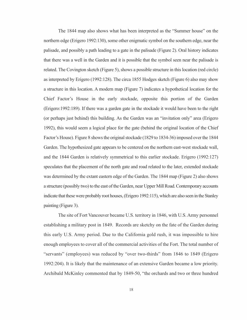
Many sources name the different fruits, vegetables, herbs and flowers growing in
24
the Garden, some of them requiring a controlled environment: cold frames for dahlias,
melons and cucumbers; greenhouses for citrons, lemons, oranges and pomegranates
(although there is no direct evidence for greenhouses at Fort Vancouver), and root houses
for storing turnips, potatoes and parsnips. Erigero (1992) provides a good overview of
these sources. Fort Vancouver was particularly noted for its apples, with observers likening
them to ropes of onions bunched for sale, and indicating that branches had to be propped
up to keep them from breaking (Erigero 1992:134). This abundance and variety of fresh
fruits and vegetables would have contributed greatly to the health of those employees
attempting to subsist on Company rations.
Numerous plants that are now considered just “flowers” were grown in the past for
medicinal uses. It is possible that nearly all of the flowers in the HBC Garden had practical
uses. If that is the case, an emphasis on aesthetic and status as represented by the presence
of certain plants, due to the labor and material resources required for their care, may be
incorrect. The simple presence of these plants is not enough. Research needs to be
conducted to determine the probability that these ornamental plants were being processed
for medicinal use. Documentary sources are very sketchy on the subject of flowers. The
only specific species mentioned are roses and dahlias). There are, however, comments
indicating that there were “ornamental plants and flowers” and “many other pretty flowers”
(Taylor 1992:Appendix D).
Many of the plants that documents indicate were growing in the HBC Garden would
have benefitted from soil enhancement practices. Research on these practices, and other
technologies that may have been used, would provide direction for reconstruction and
maintenance of the HBC Garden. Loudon’s An Encyclopedia of Agriculture: Comprising
the Theory and Practice of the Valuation, Transfer, Laying Out, Improvement, and
Management of Landed Property; and the Cultivation and Economy of the Animal and
Vegetable Productions of Agriculture is known to have been in the Dr. McLoughlin’s library
25

(Hussey [197?]:156), and should be reviewed for pertinent information. A few statements
were made in documents about soil enhancement relative to the cultivated fields at Fort
Vancouver. It is logical to assume that these methods, as appropriate, would have been
employed in the Garden. James Douglas, as an example, commented on the importance of
“keeping the soil in good heart, by fallowing and manures” (Erigero 1992:68), so it is highly
likely that manure was used in the Garden.
In reference to technology, there is an 1844 HBC inventory of Farm Utensils being
used at Fort Vancouver noting some specific garden tools: 25 Garden Hoes, and 1 English
Seed Drill (Hussey ([197?]:180). The inventory from 1848 has a specific category for
“Gardners [sic] Tools,” which includes an axe, 2 dung forks, 3 garden hoes, 2 rakes, 2 tenon
saws, a shovel and 5 spades ([197?]:180). McKie (1981:70), notes that Fort Langley
manufactured and shipped 4 garden hoses (presumably rubber as such hoses were being
manufactured elsewhere at the time) to New Caledonia, and 30 garden hoses to Fort
Colville. It seems unlikely that these facilities would have had garden hoses, and Fort
Vancouver would not. Perhaps the 1844 reference to 25 Garden Hoes should read 25 Garden
Hose, considering the phonetical spelling prevalent at the time. It seems illogical to have
25 garden hoes and only 1 or 2 of other tools, while 25 garden hoses may have been needed
to transport water in such a large space.
Historical documents, however, do not indicate how the paths in the Garden were
surfaced, or with what material. For many centuries in the western world gravel walkways
have been preferred, but nut shells, seashells, marl, crushed brick, and general debris (e.g.
tobacco pipe fragments, glass, lead shot and pottery sherds), pressed into the natural
sediments were also used (Hume 1974:22-23). According to Loudon (1824), garden paths
in general were kept level and pressed by the use of a heavy roller. It was undoubtedly
prohibitive, due to the weight, to have rollers shipped to Fort Vancouver, but the blacksmith
shop possibly could have produced them. There is no known record at this time of rollers
26

being used in the Garden at Fort Vancouver. On September 28, 1844, during the forest fire,
Thomas Lowe, HBC clerk at the Fort, noted in his diary, “Most of the men engaged in
cutting the grass in the garden, and watching the fires” (Erigero 1992:137). It is possible
that the Garden paths were planted with grass, however, Loudon considers grass paths an
inferior method, allowing one’s feet to get damp (Elliott, 2004:62). It should be noted that
the Historical Society of London’s Chiswick garden had grass paths, at least within the
arboretum (Elliott, 2004:62).
Labor
Determining who provided labor in the Garden, such as men cutting grass, is another
research goal for this project. There are a few contemporary comments in reference to
workers in the Garden. Hussey ([197?]:38) states that, “general laborers and Indian
employees undoubtedly were assigned to the garden as other duties permitted.” He also
states that the school boys, sons of HBC employees and orphans, were employed as Garden
labor, “earning their keep” according to Dr. McLoughlin (Hussey [197?]:38). A letter written
to Governor Simpson in 1833 indicated that there was only one man in the Garden (Hussey
[197?]:156). This probably means one man assigned full time (most likely Bruce). Loudon
(1824:722) indicates that, as a general rule, one full-time man per acre is required to properly
maintain a garden space. The HBC Garden, which was approximately eight acres at its
maximum, then, would have required eight full-time workers. However, the Daily Journal
of Occurrences from Fort Nisqually, a HBC fort near what is now Tacoma, Washington,
indicates that agricultural labor fluctuated greatly in its application, with resources being
utilized as demand required (Dickey 1989). This was most likely the practice at Fort
Vancouver also. In that event, there would have been periods when considerably more than
eight workers would have been required in the Garden, such as at harvest time, and times
when less than eight workers would have been in the garden as agricultural priorities shifted.
27
Of course, there were other sources of labor. The articles of agreement for British
men during the 1830s indicated that wives and children, “being found in provisions by the
said Company, if required to do so... render their services at hay-making, sheep-sheering,
weeding, and such other light work as they may be equal to.” (Hussey, c.1977:60). It is
most likely that all families of Company employees, not just those of British employees,
were required to “render services.” All the wives of the HBC employees were either full,
or some portion American Indian from the local area, with traditional resources to provide
for their families. Changes had to occur to cause these women to choose to work in the
Company Garden.
European contact did not initially change indigenous economic systems that were
already in place. Aspects that did change at the outset included an intensification of quantity
and diversification of products traded due to the introduction of pack animals. It was now
cost-effective to send higher quantities and heavy and bulky items longer distances (Teit
1928:121). Also, the demands of new trading partners (Europeans and Americans) for
subsistence items required a change in work organization and valuation. The collective
activities of the house group decreased while personal wealth (and therefore status)
increased (Oberg 1973:60). The demand for subsistence items specifically produced a shift
in the status of women. Wright (1981) and Peterson del Mar (1995) discuss the possibility
that native women’s status increased during the contact period due to the demand for their
subsistence goods. Later, as traders developed their own methods of subsistence (the HBC
became extensively involved in agriculture and salmon processing at Fort Vancouver and
other posts), the demand for these women’s products lessened even as their dependence
on imported trade goods grew. As a result, women turned to working for wages to obtain
these goods (Wright 1981:533) and the previous subsistence system became secondary.
Foraging in the immediate area of the Fort would have become difficult due to cultivated
fields, pastures and logging operations. Certainly disease also played a role in this
28

subsistence change. Some of the earliest explorers, arriving in the late 1700s, noted evidence
of smallpox having already arrived in the area (Boyd 1999:17). An intermittent fever
(assumed to be either malaria or influenza) in the 1830s dealt a final blow to much of the
native population, with conservative estimates of an 80% decrease from pre-contact
population numbers (Boyd 1999:3; Taylor and Hoaglin 1962:169). These two factors,
European contact and disease, seriously disrupted trade networks and foraging activities.
With indigenous trade networks collapsed and foraging activities difficult, the
native wives and mixed ethnicity children of the HBC employees were dependent on the
company for provisions, and may have had no choice but to work for what they received.
However, Dr. Tolmie, an officer of the HBC stationed at Fort Vancouver, and at times in
charge of agricultural activities, notes his efforts in teaching the local natives to cultivate
potatoes (Erigero 1992). Also, research has shown that indigenous and mixed ethnicity
people from Fort Vancouver had worked as farmers, and were not familiar with traditional
foodways when they arrived at the White Salmon reservation in 1857 (Deur 2011:168).
According to Hussey ([197?]:57), the majority of what are now considered
domestic activities (cooking, serving, baking, etc.), were considered “honourable”
occupations and therefore held by men in the early-to-mid 19th century. It is likely that
the women were limited to those jobs specifically stated in the articles of agreement –
“hay-making, sheep-sheering [sic], weeding, and such other light work as they may be
equal to” (Hussey c. 1977:60).
The archival research shows that the HBC Garden is consistently referred to as
being on the north side of the Fort stockade, and sometimes referred to as “Orchard,”
probably due to the presence of fruit trees in this space as well as in an orchard to the west.
The placement and dimensions of the Garden are symmetric to the early, square stockade
except for the western boundary which has different locations on the various maps. There
was one definite structure in the Garden, the Summer house, and possibly another in the
29

southwest corner near the stockade. Seeds for many imported plants were purchased by
the HBC and sent from London to Fort Vancouver, and visitors commented on additional
plants seen in the Garden, not included in the seed lists. These plants consisted of primarily
vegetables with many fruits and some herbs and flowers. The lists of specific vegetables
and fruits are extensive, while only a few herbs and even fewer flowers are noted, giving
a sense of what items were important to visitors, and possibly the Dr. who would have
been walking the Garden paths with his guests.
The Line of Fire map is the only document showing a layout of these paths, which,
according to the map, were quite wide and may have been surfaced with grass. The map
also shows a path running from the stockade to the north, in a location that would have
required a previously unknown gate in the stockade, The layout represented on the Line
of Fire map is similar to that of the Italianate Garden at the Duke of Devonshire’s estate
at Chiswick. The principal gardener, Billy Bruce, is known to have visited this garden and
to have stated his desire to emulate it. Bruce started as a laborer with the HBC, and is
consistently listed as the principal gardener approximately eight years after arriving at Fort
Vancouver. His initial job as laborer indicates a low level of education, which may have
effected certain characteristics of the Garden. The individuals that provided labor in the
Garden may have also effected some of its characteristics, as documents indicate they were
likely local American Indian wives and widows of Company employees and their children.
Even so, it is clear from the types of plants being grown that the Garden, along
with providing nutrition for the elites of the Company, was a scientific laboratory, with
plants being grown in cold frames, and probably greenhouses. It is also clear from
documents that it is a limited access, invitation only space, with Dr. McLoughlin being
the master.
30
CHAPTER 3. Summary of Research, Article and Publication Review Relating to
Garden Archaeology Projects and Methods
Research was conducted to determine the existence of garden archaeology projects in
the Pacific Northwest and worldwide. While there is room for further research, it appears that
very little garden archaeology has been conducted in the Pacific Northwest, and possibly
Western North America. Therefore, to be as informed as possible, background information
on garden archaeology outside of the Pacific Northwest was also surveyed. The review of
these projects provides insight into methods that worked in given situations, and methods that
were unsuccessful. For this project, this helped in determining methods to expend resources
on, and methods to be employed comparatively, to determine the efficiency of one to another.
For future projects, it is hoped that this research will provide a framework to aid in the
development of research designs. A summary of the results of this research follows. More
extensive discussion of each article and publication reviewed can be found in Appendix A.
Garden Archaeology in the Pacific Northwest
The first step was researching for projects in the Pacific Northwest. This was,
initially, conducted at the Oregon and Washington State Historic Preservation Offices
(SHPO), including speaking with several employees who indicated they had no memory of
archaeological projects focusing on gardens. Computer searches also produced no projects
of these types. Further research could be conducted at the Oregon SHPO, as their records
of Cultural Resource Surveys are not completely digitized.
Publications and articles were then focused on, including library catalogs, journal
databases and academic search engines. This research turned up a report by Roderick
Sprague (1983), discussing a project at English Camp on San Juan Island. Attempts were
made to find evidence of the “Royal” garden at the site (Figure 12). Remote sensing was
31

employed followed by surface stripping, with negative results. It was speculated that the
garden sediments had been removed during later activities.
Another aspect of the regional research included contacting several archaeologists,
both professional and academic, in both the U.S. and Canada, and also requesting
information through the HistArch website. The archaeologists did not know of any such
projects, and no response was received from the website inquiry.
Based on the above research, there has been only one archaeological project focusing
on a garden in the Pacific Northwest, that at English Camp, where the garden sediments
appeared to have been removed. The efficacy of the methods employed in this case cannot
be determined.
Garden Archaeology Worldwide
This research was conducted through library and journal database searches and
academic search engines, and limited to reports written in English. Nine articles are
reviewed in this thesis (Appendix A), discussing sites in Asia, Africa, the Middle East,
Continental Europe and Britain. Time periods discussed range from 100 BC to 1900 AD.
32
Figure 12. A ca. 1870 image of English Camp, with the formal garden in lower right corner. Photo courtesy
of National Park Service.
A few of the projects reviewed were experimental in terms of employing various methods
on one project to determine their effectiveness in this type of investigation.
The results of the article review suggest that, in terms of plant remains, it is possible,
even in sediments known to have characteristics that would be detrimental to pollen
preservation, for pollen to be well preserved and that analysis of these microartifacts can
be very informative (Hume 1974; Jashemski 1979; Currie and Locock 1991; Moynihan
2000). The locations of insect-pollinated plants, which generally drop their relatively heavy
pollen in the location that the plant is growing, can also be determined, through the
identification of pollen in sediments (Moynihan 2000). It is also possible to identify, by
noting differences in soil characteristics caused by the decay of roots, the locations of trees,
and, given certain circumstances, tree taxon from evidence of the configuration of roots in
the sediment (Jashemski 1995).
These sediments can also be dated by several methods, including the presence of
artifacts, as refuse was often used to loosen the soil, and analyzed for the presence of
additives used to enhance fertility (Hume 1974; Jashemski 1979, 1995; Currie and Locock
1991). The types of additives can also help to determine what was being planted.
Remote sensing (including aerial photography) can detect subtle differences between
such things as paths and beds, intricate bedding patterns, and hard landscaping (Aston 1974;
Jashemski 1979; Currie and Locock 1991; Aspinall 1997; Miller and Gleason 1999; Bedal
2001), although Currie and Locock noted that small garden beds could be entirely missed
with one meter transects. The ideal situation for this type of testing is sediments that have
not experienced alteration over time, as overlying features make it difficult to discern the
less-defined characteristics generally found in a garden (Currie and Locock 1991; Miller
and Gleason 1999).
Finally, it is indicated that less disturbing methods of sub-surface testing be initially
utilized due to the size of garden spaces, followed by mechanical scraping of later deposits
33

not related to the garden, then trenching, with close vertical controls (Miller and Gleason
1994; Jashemski 1995). Two types of excavation trench methods were reviewed; small
trenches, attempting to conserve as much of the site as possible (Currie and Locock 1991);
and large trenches, which increase the potential for understanding the geometric
characteristics of what were, relatively speaking, spaces of expansive use and concept
(Miller and Gleason 1994). Familiarity with proportions utilized in garden style layouts for
various time periods can help to determine areas of a possible garden site to focus on for
testing (Miller and Gleason 1994).
Several key points from this review can be employed in developing a research design
for, and implementing a garden archaeology project:
• Analysis of microbotanical artifacts within garden sediments can not only provideidentification of plants to (generally) genus, but also indicate where plants werebeing grown;
• Slight differences in sediments, such as those found in a garden and related to paths,irrigation, and even ornately patterned planting beds, can be seen with remotesensing equipment, provided a garden site is relatively undisturbed;
• Root casts, changes in sediment reflecting the location of a tree, are discernibleduring excavation and can provide information related to taxon;
• There are two approaches to excavation trench size advocated: small trenches inorder to preserve the archaeological record (although small is not defined); andlarge trenches, as a response to the size of identifiable aspects of a garden, and inorder to understand vertical variation within a garden
Several of these key points were used to develop the research design for this project
(Chapter 5). However, familiarity with stratigraphic sequences at the site based on previous
archaeology made the employment of some of these techniques redundant. And, it was
necessary to fit the project to the goals of the field school research design.
34

CHAPTER 4. Previous Archaeology at the Site of
the Hudson’s Bay Company Garden at Fort Vancouver
Several archaeological testing projects have been conducted within, or on the margins
of, the early- to mid-19th century HBC Garden as represented on Peers’ 1844 Line of Fire
map (Figure 2). A review of these projects follows. Figure 13 maps all of the projects
discussed below.
Louis Caywood (1955) conducted the first archaeological investigations at the site
of the HBC Fort Vancouver (Figure 13). These investigations began in 1947 and were
completed in 1952. Although no testing was done in the Garden proper, Caywood did test
along the north stockade wall and in the area of the bastion (Figure 14). These elements of
the stockade formed the southern boundary of the Garden. Caywood’s reports are very
sketchy, not unexpected for investigations conducted during this phase in the development
of historical archaeological research. Caywood (1955:38, 39, 51) indicates that a few of the
artifacts found could be related to gardening activities including metal fragments of two
hoes, two mattocks, a brass spigot and three brass spigot handles. There is little information
in the report indicating where these tool fragments were found, although the artifact database
at Fort Vancouver indicates that one of the garden hoe blades was found in the area of the
Harness Shop (just east of the Chief Factor’s House in the northeastern corner of the
stockade) and the other was found during Fur Store excavations (along the south central
portion of the stockade). Neither location is very near the Garden. Caywood (1955) does
note, however, that the spigots and spigot handles (which he attributes to water and liquor
casks) were found in the area of the bastion. As the bastion is on the southern margin of the
Garden it is possible that they were used on barrels employed to transport water to the
Garden. It is also possible that barrels with unknown contents were stored in the lower level
of the bastion.
35

36
Figure 13. Map of previous archaeology projects conducted within, and on the margins of, the HBC Garden.
The 1844 Garden Layout layer is based on HBC clerk Henry Peers’ Line of Fire map (Figure 8).

In 1966, John Combes conducted investigations on the entire north stockade wall,
also the southern boundary of the HBC Garden (Figure 13). These investigations were
conducted in preparation for the creation of concrete footings for the reconstructed stockade
wall. A 3 ft. (0.91 m) wide by 4 ft. (1.22 m) deep trench was excavated with shovels. No
screening of sediments for artifacts was performed. The excavation trench was divided into
10, 1 ft. (0.30 m) long “units,” but no vertical control was employed. A total of 2,083
artifacts was cataloged, 51% of them were some form of ceramic fragment (Combes
1966:6). Artifact concentrations in the trench corresponded with “trash pits” (actually privy
pits) excavated by Caywood. Combes’ report is singularly valuable in that it provides a
highly-detailed map of each stockade post butt that was encountered. The implications of
this map for the current excavations of the HBC Garden are reviewed below, in the
Discussion, Chapter 8.
Hoffman and Ross (1974a) also report on further excavations of the bastion, at the
northwest corner of the stockade, along the southern boundary of the Garden (Figure 13). Areas
excavated that were within the Garden produced no features or artifacts definitively
identified as being representative of garden activities.
In 1987, 51 machine-dug auger holes, 1 ft. (30 cm) in diameter, were dug at
37
Figure 14. This Caywood (1955:6, 9) profile (illustration faces north) shows the interior of the HBC bastion on
the left (west), a modern concrete sill marking the location of the original bastion wall (11), and the HBC Garden
on the right (east). Strata 3 and 4 represent WWI deposits, Stratum 5 is the 1894 flood silt, Stratum 6 (inside the
bastion) is debris from the bastion burning, Stratum 7 (outside the bastion) is mixed clay and ash, also from the
bastion burning. Strata 8 and 9 consist of backfill from the construction of the bastion. Stratum 10 is moist, loose
silty clay with occasional bits of wood, charcoal and HBC artifacts in the upper portions. This stratum (10) was
not identified as either “disturbed” or “intact” in the report. Stratum 11 is fill from 1947 excavations.
Bastion Garden

approximate 50 ft. (15.24 m) intervals between the “existing rows of orchard trees” in the
HBC Garden in preparation for the installation of an irrigation system (Thomas 1987).
Unfortunately, no map of the project is available. The report summary indicated that no
significant cultural deposits would be effected by the irrigation project. This report is
interesting in that it notes a previous archaeological project on the site of the HBC Garden
for which there does not appear to be any documentation: “monitoring and artifact recovery
during NPS plowing of the historical scene interpretive garden” (Thomas 1987:1).
Photographs indicate that the “interpretive garden,” and also plowed areas for the planting
of cereal crops, were originally located on both the east and west sides of the path into the
north gate of the reconstructed stockade (Figure 15). So the above-mentioned monitoring
(and historical scene plowing and gardening activities) would have partially taken place on
the site of the HBC Garden, disturbing the intact deposits on the eastern boundary.
Another project, focusing on remote sensing, specifically soil electrical conductivity
metering and ground penetrating radar (GPR), was used to test the Summer house location
38
Figure 15. Aerial photo (facing northwest) from The Columbian newspaper in 1974 showing the reconstructed
HBC stockade and the two dark plowed strips (green arrows) on either side of the north gate. The plowed
strip on the west (left) side is in the HBC Garden site. The dotted line represents the boundaries of the Garden
as shown on the Line of Fire map (Peers 1844).
North Gate

39
and a possible well location in the Garden (Bell 1991). The location of the Northern test
area (Figure 13), the probable location of the Summer house, was determined through
analysis of the Line of Fire map (Peers 1844) and contemporary illustrations (Figures 3, 4,
5 and 6). More than 10 transects, each about 100 ft. (30.48 m) in length, were run utilizing
each remote sensing method. Transects were generally 25 ft. (7.62 m) apart, however, trees,
fences and structures were avoided. The conductivity testing was performed on park
property only, as the U.S. Army portion of the site is covered in asphalt. Three subsurface
anomalies were found on park property, all of which were attributed to 20th century
ground-disturbing activities. The GPR testing, however, was extended to U.S. Army
property. Two of the anomalies located, SSA-6 and SSA-7, were interpreted to be possible
foundation remains (Figure 16). Applying a schematic of the Garden layout, based on the
1844 Line of Fire map, to these remote sensing maps places the east wall of the Summer
house approximately in the location of anomalies SSA-6 and SSA-7 (Figure 17).
The Southern test area, (Figure 13) the possible location of an HBC-period well, was
also tested with both sensors. A survey area 100 ft. (30.48 m) north-south and 220 ft. (67.06 m)
east-west was laid out with the southwest corner, 1 ft. (0.30 m) north of the north stockade wall
and 300 ft. (91.44 m) east of the stockade/bastion intersection. Five transects, 25 ft. (7.62 m)
apart and 200 ft. (60.96 m) in length were completed. What was interpreted to be a well, between
5 and 9 ft. (1.52 m and 2.74 m) in diameter, was located in a surface depression by both sensors.
In this area the distance between transects was decreased to 3 ft. (0.91 m). The anomaly was
interpreted to be a back-filled, masonry-lined shaft feature, consistent with an HBC well.
Monitoring was conducted in 1994 during the digging of a trench along the south
side of East 5th Street (Figure 13) for a telephone upgrade (Freidenberg and Thomas 1994).
A maximum 1.5 ft. (0.46 m) wide by 3.5 ft. (1.07 m) deep trench was machine-excavated.
The northern edge of this trench was 3 ft. (0.91 m) south of the NPS rail fence, within the
HBC Garden site, extending “eastward from the telephone pole for approximately 110 ft.

N
Fig
ure
16.
Cult
ura
l as
pec
ts o
f th
e m
oder
n l
andsc
ape
wit
h 1
991 G
round P
enet
rati
ng R
adar
(blu
e) a
nd S
oil
Conduct
ivit
y M
eter
(re
d)
Nort
her
n t
esti
ng r
esult
s
over
layed
. T
hes
e re
mote
sen
sing t
est
area
s w
ere
on t
he
nort
her
n e
dge
of
the
HB
C G
arden
, as
docu
men
ted o
n h
isto
ric
map
s (P
eers
, 1844;
oth
er m
aps)
, in
the
poss
ible
loca
tion o
f th
e su
mm
erhouse
. U
nit
s ar
e in
fee
t. (
Bel
l 1991)
Asp
halt
Park
ing
Lot
40

41
(33.52 m). At this point the trench turned south and ran along the western edge of the current
Garden Exhibit. This north-south running portion of the trench is outside of the HBC Garden
site. No HBC-period artifacts were noted in the east-west running portion of the trench,
which was within the HBC Garden site. The report does not note whether the deposits
exposed during the trenching project were intact or disturbed, so it is impossible to
determine if the lack of artifacts found in the portion of the trench dug on the Garden site
has any significance to HBC Garden activities.
Another project was conducted in 2001 in the area of the Garden. Four shovel tests
were dug along the proposed route (Figure 13) of the Discovery Loop Trail (Cromwell,
2001). Although the report states that “[a]rtifacts from every historic period associated with
the Vancouver National Historic Reserve (VNHR) were recovered in every excavated shovel
Figure 17. The relationship of anomalies (SSA-6 and SSA-7) found during remote sensing and identified as
possible building foundations (Bell 1991), and the Garden layout, including the Summer house, based on the
Line of Fire map (Peers 1844).

test” (Cromwell 2001:3), the tables of Recovered Artifacts for Shovel Tests ST1 through
ST4 (those in the Garden) do not attribute any artifacts to the HBC period (Cromwell
2001:7-8). The report does state, however, that intact sediments were found below 30 cm
in STs 1 through 3, providing impetus for further testing in that area of the Garden. The
sediment characteristics of ST 4 are not noted, but the recovered artifacts table (Cromwell
2001:Table 4) shows that 20th century artifacts were found throughout, and in Level 5, 40
to 50 cm bs, indicating disturbed deposits.
Another project in the area of the bastion, a mechanically-dug, narrow trench on the
north side of the reconstructed north stockade wall, was archaeologically monitored in 2002.
The trenching was completed within deposits disturbed during the reconstruction of the
north stockade wall. No features were found and artifacts, a mix of HBC and U.S. Army
items, were not collected (Cromwell 2002).
Two shovel tests were dug in 2009 (Figure 13), after the fieldwork reported in this
thesis was completed, in deposits which would be impacted during the demolition of U.S.
Army building P-408, which sat on the western edge of the HBC Garden, on the south side
of East 5th Street (Horton 2009). Shovel Test 01 was excavated to 80 cm, and Shovel Test 02
was to 100 cm. Intact 19th century deposits were found, however the artifacts were of low
diagnostic value and none were identified to the HBC occupation.
Previous archaeology conducted on the Garden was essentially limited to the margins
of the site. While intact sediments were found in shovel tests dug near the eastern boundary
(Cromwell 2001) and the northern boundary (Horton 2009), and units near the bastion
(Caywood 1955), artifacts were few and non-diagnostic to gardening activities. Investigations
of the north stockade wall provided valuable information towards interpreting features found
during the 2005 field season of this project. Remote sensing (Bell 1991) provided evocative
anomalies in the possible location of an HBC well, near the north wall of the stockade, and in
the possible location of the HBC Summer house, on the northern edge of the Garden.
42

CHAPTER 5. Archaeological Research Design and Methods
for the Fort Vancouver Garden Project
The primary goals for the archaeological research portion of this project were to
determine:
• the layout, dimensions and characteristics of the beds and paths
• the location and characteristics of the historically documented garden well (Well #4)
• the identification of plants cultivated in the garden
• the identification of artifacts from which inferences can be drawn relating to the useof the Garden and perhaps the gender, age and ethnicity of the gardeners
• to confirm historical documents that the garden was a limited-use space
• the identification of hard landscaping (irrigation, path borders, structures, etc.)
• the identification of soil enhancement techniques
• any changes to the layout, dimensions and characteristics of the garden over time
• testing of two different methods of garden excavations: large trenches (utilizedextensively in the eastern United States on colonial sites (Miller and Gleason 1994),and small trenches, the preferred method in England (Currie and Locock 1991).
As noted above, several occupations post-dating the HBC were located in the same
horizontal space as the Garden. Some of these occupations have been agricultural, some
industrial. All occupations have created some degree of sediment disturbance. With that in
mind, an excavation strategy (detailed below) involving Fort Vancouver historic map,
illustration and photo research, information obtained through garden archaeology research
(Chapter 3), and previous archaeology at the site (Chapter 4) was developed. The results of
this research guided the positioning of excavation units in areas that historically have had
the least disturbance. Beyond that consideration, units were positioned to address specific
research questions, and the results of Bell’s (1991) remote sensing project.
43

To achieve the goals noted above, research of archaeological documents focused on
methods to apply that could result in information on the following expectations:
• there would be some disturbance of HBC deposits,
• remote sensing would not be effective due to overlaying occupations andactivities,
• a path would be distinct from a bed, allowing for extrapolation of the Gardenlayout.
• tree root casts would be found,
• aspects of hard landscaping would be found,
• changes to the size of the Garden would be discernible as changes in layout,
• artifact quantities would be low relative to other areas of Fort Vancouver,
• artifacts may have been used to “loosen up” clay sediments,
• pollen and phytoliths would be well-preserved and provide information on whatplants were grown in the Garden, where they were grown, and whether the pathswere surfaced with grass.
These expected conditions can be determined archaeologically through the
identification of differences in sediment texture and structure, the type and quantities of
artifacts found, and analysis of sediments for microbotanical artifacts.
2005 EXCAVATION STRATEGY
The 2005 strategy employed the eastern United States “colonial sites” method of larger
trenches (see Chapter 3). Figure 18 shows two “Test Areas,” TA1 and TA2, excavated during
that season. The 1844 Line of Fire map (Figure 2), which delineates a Garden layout, drove
trench placement decisions. Erigero (1992:128) estimates that the paths represented on this
map were 20 feet wide. When developing the schematic drawing used for trench placement
the proportions shown on the Line of Fire map (relative to the length of the north stockade
wall from the western gate post to the northwest corner) suggest paths approximately 30
44
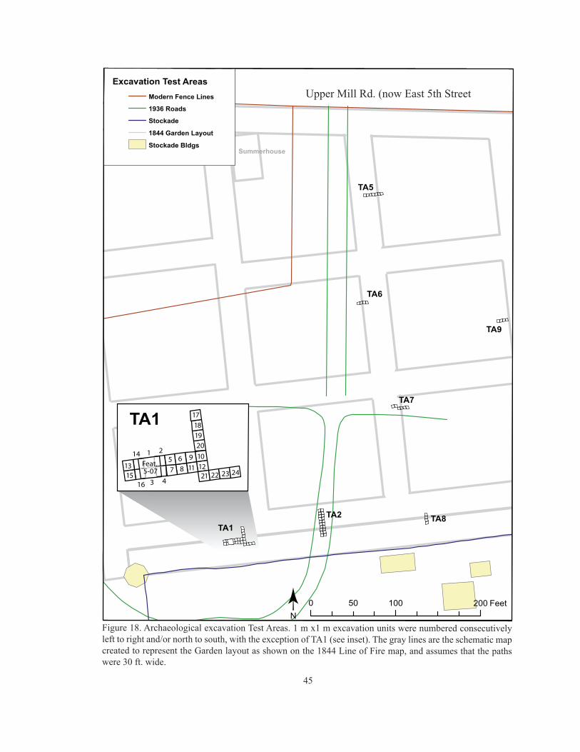
45
Figure 18. Archaeological excavation Test Areas. 1 m x1 m excavation units were numbered consecutivelyleft to right and/or north to south, with the exception of TA1 (see inset). The gray lines are the schematic mapcreated to represent the Garden layout as shown on the 1844 Line of Fire map, and assumes that the pathswere 30 ft. wide.
Upper Mill Rd. (now East 5th Street

feet in width. This dimension is also viable as it coincides with 5 toise.*
Test Area 1 (TA1): As the results of remote sensing (ground penetrating radar and soil
conductivity) conducted in two locations on the inferred Garden site (Bell 1991) had not been
sub-surface tested, it was decided to excavate in the location of the inferred “well” in the
southwest corner of the site. GPR was run over this location again in 2005 as a demonstration
for Field School students, using an antenna for deeper investigation (as compared to 1991), with
similar results. Also, a distinct depression, possibly the well, was located in this area. GIS
maps indicate that the depression is located directly under the south wall of a WWI Spruce
Mill building. Further, Bell (1991) interpreted the results of the GPR testing to indicate the
presence of a “back-filled, masonry-lined, well.” A 2 m x 8 m trench consisting of 16 1 x 1
m units was excavated in this location, placed to cross this depression. The trench was begun
during a PSU Field Methods class practicum, and continued during the field school. The
trench was divided into 1 m x 1 m units (Figure 18), which were excavated concurrently.
Unit TA1-16 was excavated independently as a control unit, to determine the expected
stratification at the site.
Test Area 2 (TA2): East of TA1, was 2 m x 10 m, consisting of 20 1 m x 1 m units,
which were also excavated concurrently, other than TA2-20, a control unit which was
excavated individually to determine stratification in this area.
TA2 was located to potentially cross the edge of the southern east-west Garden path
as shown on the Line of Fire map (Peers 1844), from the bed against the north stockade
wall. The intent was to determine if distinct stratification changes related to the path were
present. This trench potentially crossed a path edge into planting beds south of the path.
The Line of Fire map also suggests a feature centered east to west in the garden, near the
46
*toise: a French unit of measurement equaling 1.949 meters utilized in colonial Quebec and often employed
in fur-trade architecture. (http://www.sizes.com/units/toise.htm, accessed 3/6/11). It appears that this unit
of measure was used in the HBC Village (Mulalley 2011:44), but results of archaeological research on
remains of buildings inside the stockade indicate that English Feet was the measurement method utilized
in this location (Brauner 1995; Hoffman & Ross 1973, 1974, 1976, Thomas 1991).

47
stockade wall, possibly a path. This trench was placed to determine the nature and characteristics
of that possible path feature. However, possible disturbance was high in this area. GIS maps
confirm the presence of a 1930s road in this location.
2006 EXCAVATION STRATEGY
The test excavation strategy for the 2006 field school was based on the results of the
2005 excavations and additional review of extant historical maps, drawings, other illustrations,
and historical and aerial photographs. The testing research design was altered based on the
findings from the 2005 excavations, and to address the relative value of large versus small
trenches (as utilized in England). Specifically, shorter and narrower test trenches attempted
to follow out some of the probable garden paths based on the Line of Fire map (Peers 1844).
Further, one trench tested the location of the root houses northeast of the garden, to determine
if this area contained intact remains of the structures and their contents (Figure 18). The results
of the trench to locate the root houses is not included in this document.
Test Area 1 (TA1): Based on the results of 2005 excavations (see Feature 507,
Appendix C), work here was continued, employing shoring to test if the feature was a well
dating to the HBC period. In addition, two 1 m x 4 m test trenches (units 17-24) were
excavated north and east of the 2005 excavation block to follow out a compacted surface
identified as a possible garden path (see Feature 509 below).
Test Areas 5, 6, 7 and 8 (TA5, TA6, TA7, TA8): These 1 m x 4 m trenches were placed
to explore the location of the boundary between Garden paths and Garden beds, based on the
Line of Fire map (Peers 1844), in order to extrapolate the remaining geometric layout of the
Garden. It was also hoped to find distinctive strata, features, and artifacts associated with
other garden hard landscaping.
Test Area 9 (TA9): After information was obtained at Colonial Williamsburg relating
to the methods employed in creating hot beds in the 19th century, an additional 1 m x 4 m

trench was excavated in the proposed location of these structures in the HBC Garden
(Erigero 1992:128). According to Loudon (1824:766), hot beds consisted of an approximate
2 ft. (.61 m) wide and 3 ft. (.91 m) deep hand-dug trench which was then filled within 1 ft.
(30 cm) of the surface with fresh manure. The remaining area was filled with dirt. Seeds
and young plants generally native to warmer environments were then planted in the hot
bed, which was often covered with a cold frame (glass and wood, essentially a flatish,
portable greenhouse). The rotting manure would heat the dirt, allowing the seeds to
germinate, or the plant to grow. TA9 was placed along what is inferred to be the eastern
edge of the eastern-most Garden bed, in an area that appears to have had little disturbance
by later occupations (Figure 18).
The sampling strategy for pollen, phytolith and macrofloral analysis implemented
in 2006 was identical to that employed in 2005, minus the column sample.
SPECIAL SAMPLING
A sampling procedure was developed to collect sediment samples for the extraction
of pollen grains and phytoliths. Sediment was collected for each testing method from
deposits determined (by artifact identification and sediment characteristics) to be intact
HBC period. Trowels were cleaned prior to collecting the sediment sample by wiping them
on a paper towel. Sediment samples were consistently taken from the northwest 50 cm x
50 cm quadrant of a given 1 m x 1 m unit. The surface of the intact deposit was first scraped
so that the sediments collected would be freshly exposed and therefore not contaminated
with modern pollen. Sediments for pollen analysis were collected first, with sediments for
phytolith analysis taken immediately afterward from the same location. Sediments for the
two forms of analysis were bagged separately and labelled.
Sediment samples from a non-Garden provenience were taken for comparison to
those samples taken from the Garden (as inferred from the 1844 Line of Fire map)
48

(Appendix G). This non-Garden provenience was located approximately 516 m from the
northeast corner of the Garden site, and approximately 632 m from the location of the
sediment samples taken during the HBC Garden project, just north of the Fort Vancouver
National Historic Site Visitor Center. From the 1820s to the present, the area was first an
HBC agricultural field (Hussey [197?]:108), then U.S. Army Parade Ground, and finally
NPS property. The samples were taken from the north wall of a shovel test excavated during
testing related to a remodeling project at the Visitor Center (Cheung et al 2010).
Sediment samples for this project were sent to Paleo Research Institute, Golden,
Colorado, for phytolith analysis (Appendices D and E). Samples for pollen analysis were
sent to both Paleo Research Institute (Appendix E) and the Andrew Fiske Memorial Center
for Archaeological Research at The University of Massachusetts Boston, Boston, MA
(Appendices F and G). Samples for macrobotanical analysis were also sent to the Andrew
Fiske Center (Appendix H).
EXCAVATION METHODS
Sediments were excavated during both field seasons in stratigraphic levels, or no
more than 10 cm arbitrary levels for strata that were more than 10 cm thick. Intact HBC
deposits were excavated in stratigraphic levels, or 5 cm-thick arbitrary levels. It was
assumed, based on previous excavations at the site, that the stratification of sediments within
the HBC Garden would be distinctive and include deposits related to NPS activities, the
fill from the WWI spruce mill, and the HBC period.
Deposits up to and including the WWI spruce mill fill were excavated using skim
shoveling and breaker bar, while intact HBC deposits were excavated by trowel. Excavated
sediments were sieved through nested 1/4 in. (0.64 cm) and 1/8 in. (0.32 cm) wire mesh
hardware cloth.
A Total Station was used to confirm baselines, set to the orientation of the Garden
49

and stockade. Excavation units were set off of these baselines. Vertical provenience was
maintained using a vertical datum tied into the unit through the use of a unit datum, line
levels, and string, or in some cases, an optical level.
Matrix recovered from the excavations was sieved through nested ¼- and ⅛-inch
(6 and 3 mm) mesh hardware cloth. Collected artifacts from each unit were separated by
material and bagged by excavation level or feature. A bag catalog for each unit was
maintained in the field to track the collection. Information from each level was recorded on
an NPS level record form, including the site name and number, the unit provenience, feature
designator, level, strata, excavator, date of excavation, excavation technique, a plan sketch
(if appropriate), a detailed sediment description, inventory of samples, and descriptive
section. At least two walls of each block excavation were profiled and photographed (using
a digital camera and black and white print film). The profiles were drawn to scale, showing
stratigraphic breaks, strata designations, soil constituents, feature boundaries, and evidence
for disturbance.
Features were given a unique number and documented photographically, on feature
forms, and with a scaled plan and profile sketch. As deemed appropriate, wood and sediment
samples were collected. Artifacts found within features were collected by stratigraphic unit
and these strata were measured vertically and horizontally.
Artifacts were prepared, processed, analyzed, and curated to the Secretary of the
Interior’s standards at the Fur Store curation facility at Fort Vancouver National Historic
Site. All recovered artifacts were cleaned by either wet washing or dry brushing. Artifacts
from each unit of provenience were assigned a unique field lot number. Bags of ceramics,
glass, ferrous metal, other metal, faunal remains, stone artifacts, and diagnostic artifacts from
each lot were assigned a unique field specimen number. Lab activities were conducted by
NPS volunteers under the coordination and supervision of the author, and with the assistance
of Doug Wilson, Bob Cromwell, Tessa Langford, Danielle Gembala, Heidi Pierson, Leslie
50

O’Rourke and Beth Horton. A computer-based database for all recovered materials was
maintained to track the materials through the various analysis steps. After cleaning, artifacts
were analyzed by material type, manufacturing and technological characteristics, and
formation process traces. Previously constructed typologies for Fort Vancouver were
employed to identify the collected artifacts. The artifacts from this project were cataloged
with the NPS’ Interior Collections Management System (ICMS) software, and are stored
under accession numbers 3047 and 3062.
Field work was conducted from May 20, 2005 to August 5, 2005; June 13, 2006 to
August 4, 2006 and August 13, 2007 to August 24, 2007. The field crew for 2005 consisted
of: Doug Wilson, Principal Investigator; Field Supervisors Elaine Dorset and William
Gardner O’Kearney, PSU Anthropology Dept. graduate students; Beth Horton and Amitava
Chowdhury, WSU PhD. candidates, and 24 university students. Lab Director was Danielle
Gembala, University of Washington PhD candidate. The field crew for 2006 consisted of:
Doug Wilson, Principal Investigator; Field Supervisors Elaine Dorset and Meris Mullaley,
PSU Anthropology Dept. graduate students; Beth Horton and Amitava Chowdhury, WSU
PhD. candidates, and 17 university students. Lab Director was Heidi Pierson, Chico State
University graduate student.
51

CHAPTER 6. Archaeological Testing Results
The archaeological excavations resulted in little macroscopically visible
information, such as distinctive sediments related to paths and planting beds, hard
landscaping (border materials, irrigation features, water features), and root casts, related
to the existence and characteristics of the Garden. Several of the units were determined
definitively to consist of disturbed deposits, while others were questionable. Figure 18
indicates the locations of the Garden site excavation units and Appendix B provides a
summary of the results of each unit. Specific information is noted in this chapter relating
to several HBC features. The characteristics of these features infer that they represent
activities on this landscape during the HBC occupation. Discussion of two features from
later occupations at the Garden site (Features 505 and 507) can be found in Appendix
C. The remainder of the features from later occupations are not discussed in this
document. Finally, a summary of artifact quantities and distribution is provided, and
several distinctive artifacts are described.
A summary of results in this chapter:
• all trenchs contained disturbed sediments, several of the small trenches had no intact deposits;
• the large trenches had localized disturbances with surrounding intact deposits;
• a stratigraphic sequence for the Garden site was established. The presence of Stratum IV, the 1894 flood silts, in the strata was used as a marker indicating intact deposits below;
• the anomaly noted during GPR testing at TA1 inferred to be an HBC well, was determined to be a WWI dry well;
• a compacted surface within the HBC deposits was found at TA1, expanding beyond the unit walls of the trench
• two other features, strips of ultra-compacted sediments and a probable hearth were also found in TA1;
• remains of a small post were found in TA8, most likely from the HBC period.
52

As noted above, both large trench excavations (TA1 and TA2) and several small
trenches (TAs 5 through 9) were dug during this project. Both sizes of trenches had areas
of disturbance. However, the larger amount of excavation done within a contiguous area
resulted in finding intact deposits adjacent to the localized disturbed areas.
The results of excavations in TA1, the “well” location that was GPR tested in 1991,
and again in 2005 with similar results, indicate that what initially appeared to be anomalies
consistent with those found related to a known well inside the fort palisade (Bell 1991),
was actually a later occupation (mid-twentieth century) trash pile, approximately 4 m in
diameter, which had been used to fill a dry well, probably dating to WWI when many
temporary housing buildings, including bath houses, were located on the Garden site (see
Feature 507, Appendix C).
STRATIGRAPHY
A consistent stratigraphic sequence was developed for undisturbed deposits at the
Garden site (Figure 19). This sequence is as follows:
Stratum I: Sod, NPS Fill
Stratum II: Modern U.S. Army (1920-1948)
Stratum III: U.S. Army WWI Spruce Mill (1917-1918)
Stratum IV: Flood Silt Deposit (1894)
Stratum V: Early U.S. Army and HBC occupation (1829-1894)
Stratum VI: Culturally Sterile (pre-1829) B Horizon
Stratum VII: C Horizon Gravels
The presence of Stratum IV (1894 flood silt) was used as a marker indicating that
Hudson’s Bay Company deposits below (representing the inferred Garden), were intact.
Appendix B indicates excavation units containing Stratum IV flood silts.
TA5 (Figure 18) contained probable disturbed sediments, with wire nails and other
53

20th c. artifacts through out the deposits and a gravel stratum (Feature 614) probably
associated with a 20th C. road. Only units 1, 5, 6, and 7 were excavated in this trench. TAs
6 and 9 were also determined to be disturbed, containing probable WWII fill. TA7 contained
two features (616 - horizontal linear wood and 619 - compacted sediment), that were initially
thought to be related to HBC activities, but the presence of wire nails and plastic defined
the features as 20th century.
HUDSON’S BAY COMPANY PERIOD FEATURES
Four features were found during this project that could definitively be attributed to
the HBC period (Table 1). Three of the features: Feature 509, a compacted surface; 509A, a
54
Stratum 1Stratum II
Stratum V
Stratum VI
Stratum IV
Stratum III
Figure 19. A typical profile of sediments at the HBC Garden site, found in the west wall of excavation units
TA1-13 and TA1-15. Photo courtesy of the National Park Service.
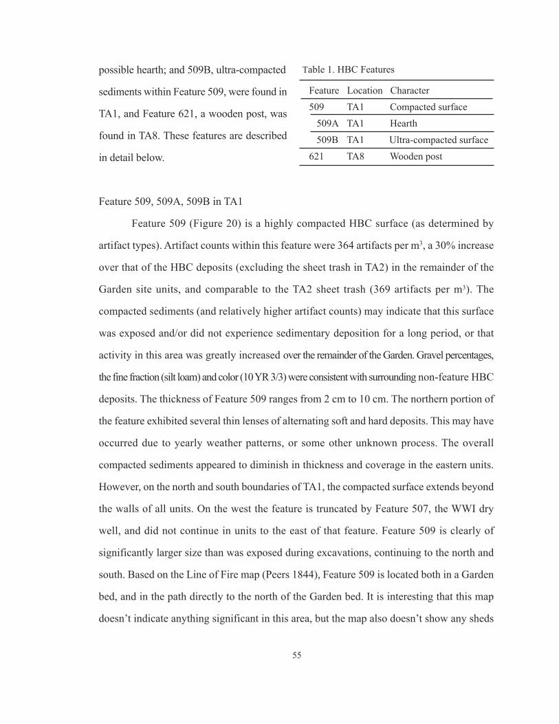
possible hearth; and 509B, ultra-compacted
sediments within Feature 509, were found in
TA1, and Feature 621, a wooden post, was
found in TA8. These features are described
in detail below.
Feature 509, 509A, 509B in TA1
Feature 509 (Figure 20) is a highly compacted HBC surface (as determined by
artifact types). Artifact counts within this feature were 364 artifacts per m3, a 30% increase
over that of the HBC deposits (excluding the sheet trash in TA2) in the remainder of the
Garden site units, and comparable to the TA2 sheet trash (369 artifacts per m3). The
compacted sediments (and relatively higher artifact counts) may indicate that this surface
was exposed and/or did not experience sedimentary deposition for a long period, or that
activity in this area was greatly increased over the remainder of the Garden. Gravel percentages,
the fine fraction (silt loam) and color (10 YR 3/3) were consistent with surrounding non-feature HBC
deposits. The thickness of Feature 509 ranges from 2 cm to 10 cm. The northern portion of
the feature exhibited several thin lenses of alternating soft and hard deposits. This may have
occurred due to yearly weather patterns, or some other unknown process. The overall
compacted sediments appeared to diminish in thickness and coverage in the eastern units.
However, on the north and south boundaries of TA1, the compacted surface extends beyond
the walls of all units. On the west the feature is truncated by Feature 507, the WWI dry
well, and did not continue in units to the east of that feature. Feature 509 is clearly of
significantly larger size than was exposed during excavations, continuing to the north and
south. Based on the Line of Fire map (Peers 1844), Feature 509 is located both in a Garden
bed, and in the path directly to the north of the Garden bed. It is interesting that this map
doesn’t indicate anything significant in this area, but the map also doesn’t show any sheds
55
Feature Location Character
509 TA1 Compacted surface
509A TA1 Hearth
509B TA1 Ultra-compacted surface
621 TA8 Wooden post
Table 1. HBC Features
56
Figure 20. Features 509, 509A and 509B in TA1.
Location of
Feature 509
57
or other support-type facilities on the local landscape.
Feature 509A (Figure 20) was a possible hearth located in the southeastern portion
of the TA1, at the bottom of Feature 509. The feature was approximately 8 cm thick, 73 cm
wide, and continued into the south wall of unit TA1-24. The total shape could not be
determined, but the exposed portion had curved edges, implying a circular shape. The gravel
percentage in the sediments increased by 100%, with a significant amount of charcoal in
very poor condition, preventing collection of more than a small sample (n=18).
Feature 509B (Figure 20) was a total 1 m-wide by 5 cm-thick set of “strips” of
extremely compacted sediments in the north central portion of Feature 509. These
compacted strips may have been created when an object of great weight was placed in this
area. An example would be the support structure for water barrels.
Feature 621
Feature 621 was a wooden post located in the west wall of TA8, in the south central
area of the Garden (Figure 21) probably from the HBC period. There was no discernable post
hole, probably indicating that the post was simply driven into the ground. Stratum IV, 1894
flood silt, was found at this location, near the top of the post. The post was either still present
at the time of the flood, or placed into the ground after it, as the flood silts surround the remains
of the post rather than flowing over it. These remains are about 4 cm thick by 6 cm wide and
13 cm in length. The wood was quite degraded, and it is unknown if it was a milled piece or
unworked. One fragment of free-blown, light olive vessel glass was found in Feature Level 2
(10-20 cm from the top of the post, Stratum V HBC). Two flat glass fragments found within a
10 cm level of sediment underneath the post date to 1830-1845, based on a thickness of 1.24
mm (.048 in.) (Roenke 1978). A pollen sample taken immediately below the post contained
crocus and horehound, both introduced plants.
A review of available historical maps for this location indicates uses such as

58
“meadows” (unknown cartographer 1870), “pasture,” (Wood 1879), “Company gardens,”
(Lydecker 1889), and “skirmish range” (McCrea 1892) after the HBC occupation and up
to WWI. These activities are not compatible with having posts on the landscape. The soldiers
most likely grew relatively labor-free root vegetables in their garden, and would not have
required support posts for trellises. As the post was truncated some time previous to the
WWI sand and gravel fill event to prepare the landscape for the spruce mill, it is likely that
this post feature is an aspect of the HBC occupation.
In summary, several of the small trenches contained disturbed deposits. The two
Figure 21. Profile of west wall of TA8, showing Feature 621 post on right (VII). Image courtesy of the National
Park Service.

large trenches, TA1 and TA2, also contained localized disturbed deposits surrounded by
intact sediments. A stratigraphic sequence was developed for the site. Four HBC-period
features were found. A highly-compacted surface in the area of TA1, with relatively high
density of artifacts. The boundaries of this feature appear to be at the east end of TA1, in
the area of Feature 507 (dry well) on the west, while the north and south boundaries could
not be determined as they extend past the excavations in TA1. Associated with this feature
are a highly-compacted area (Feature 509B, and a hearth (Feature 509A). Feature 621 (TA8),
the remains of a post, is likely from the HBC period.
The possible location of an HBC well, in TA1, was determined to be a dry well from
the early 20th century WWI spruce mill, which had been later (post 1935) filled with
primarily architectural trash. No changes in sediment that could have represented garden
paths was found.
59

60
CHAPTER 7. Artifacts and Archaeobotanical Remains
This chapter discusses artifacts found within HBC deposits. None of the artifacts
were clearly representative of gardening activities, however, the fact that they were
deposited during the HBC period, in a known Garden (based on historial documents and
results of this project), implies that they represent some type of activity in the Garden. A
spatial distribution analysis of total artifacts is reviewed, artifact types and quantities are
briefly discussed, and classified by function. Microartifact (pollen and phytolith) analysis
of sediment samples obtained from HBC deposits is also reviewed. A discussion of the
results generated from this data can be found in Chapter 8.
A summary of results in this chapter:
• the artifact distribution shows relatively higher quantities of artifacts associated with the compacted surface (Feature 509) in TA1, and in the west central portion of TA2;
• overall, artifact quantities found at the site are significantly lower than those found in other locations at Fort Vancouver;
• artifact types were dominated by architectural items (41%) no artifacts specific to gardening activities were found, a very few artifacts relating to gender and/or class were recovered, the majority from the TA2 sheet trash, in terms of domestic artifacts, vessel glass dominated at TA1 and ceramics at TA2.
• phytolith analysis indicates that the site was a meadow with native grasses, andthat this signature does not change over time
• pollen analysis identified many plants already known from documents to have been grown in the Garden, plus several previously unknown plants.
• spatial distribution analysis of absence/presence of pollen indicates where certain plants were growing in the Garden
ARTIFACT DISTRIBUTION
Excavation trenches were placed in locations (Figure 22) that were hoped to show a
transition in sediment characteristics from a Garden bed to a Garden path, based on a GIS

61
map created from the Garden layout as represented in the Line of Fire map (Peers 1844). It
was hypothesized during devel op ment of the project that it was possible for there to be either
more artifacts in the Garden beds, as it had been common practice for many centuries to
loosen sediments by adding trash, or for there to be more artifacts in the path areas,
representing items dropped by gardeners and visitors. Either case would have been
represented in the archaeological record as significant differences in the spatial distribution
of artifacts. Figure 22 indicates the spatial distribution, based on artifact counts per m3, of
all artifacts recovered from the HBC strata during these excavations. TAs 5, 6 and 9, in the
northern portion of the site, consisted of disturbed sediments and did not contain intact HBC
deposits. When looking at only the trenches that contained intact HBC sediments (TAs 1, 2,
7 and 8), as shown in the figure, there is no consistent pattern of artifact distribution that
Figure 22. Spatial distribution of all artifacts.
0-311
312-622
623-933
934-1,245
1,246-1,555
1,556-1,867
Bastion0 50 100 200 Feet

illustrates a boundary or transition between Garden path and Garden bed. TA7 and TA8 had
higher artifact counts in the “path.” TA2’s distribution is anomalous on the south end due to
an inferred sheet trash deposit (see Discussion below), however, artifact counts were low in
the “path” area of the trench as compared to TA7 and TA8. TA1 exhibits an overall anomalous
distribution, with the western portion of the trench disturbed by later WWI activities, and
the remainder of the trench (which contains Feature 509, compacted surface) having a
variable artifact distribution.
The 2004 Powder Magazine excavation inside the Fort stockade (Pierson et al.
2009:Table 8), and 2011 HBC Village excavations (Wilson, report pending) provide data
for an intersite artifact count density comparison (Figure 23). This comparison provides
supporting evidence for statements in historical documents that access to the Garden was
limited. The Village, like the Garden, was also adjacent to the fort stockade, but was a living
space for the Company’s employees, while use of the Garden was restricted based on the
hierarchical structure of fur-trade society. Narcissa Whitman, among others, indicated that
62
Figure 23. Locations of excavation units (Village, Powder Magazine) used for artifact quantity comparison
to the HBC Garden site.
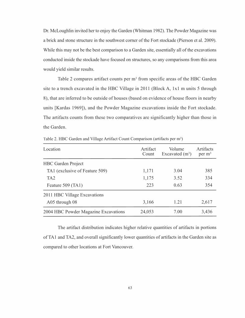
Dr. McLoughlin invited her to enjoy the Garden (Whitman 1982). The Powder Magazine was
a brick and stone structure in the southwest corner of the Fort stockade (Pierson et al. 2009).
While this may not be the best comparison to a Garden site, essentially all of the excavations
conducted inside the stockade have focused on structures, so any comparisons from this area
would yield similar results.
Table 2 compares artifact counts per m3 from specific areas of the HBC Garden
site to a trench excavated in the HBC Village in 2011 (Block A, 1x1 m units 5 through
8), that are inferred to be outside of houses (based on evidence of house floors in nearby
units [Kardas 1969]), and the Powder Magazine excavations inside the Fort stockade.
The artifacts counts from these two comparatives are significantly higher than those in
the Garden.
63
Table 2. HBC Garden and Village Artifact Count Comparison (artifacts per m3)
Location Artifact Volume ArtifactsCount Excavated (m3) per m3
HBC Garden Project
TA1 (exclusive of Feature 509) 1,171 3.04 385
TA2 1,175 3.52 334
Feature 509 (TA1) 223 0.63 354
2011 HBC Village Excavations
A05 through 08 3,166 1.21 2,617
2004 HBC Powder Magazine Excavations 24,053 7.00 3,436
The artifact distribution indicates higher relative quantities of artifacts in portions
of TA1 and TA2, and overall significantly lower quantities of artifacts in the Garden site as
compared to other locations at Fort Vancouver.

ARTIFACTS
A total of 3,990 artifacts were found in 10.65 m3 of HBC deposits excavated during
these investigations. These artifacts, along with all documents generated during this project,
are stored in the curation facility at Fort Vancouver National Historic Site, cataloged under
accession numbers 3047 and 3062.
A brief overview of artifact types and their functional classifications (Sprague 1981),
follows. While the artifacts themselves may not, in a literal sense, reflect activities in a
Garden, they were found in HBC deposits, within a Garden known both from historical
documents and the results of microbotanical analysis of sediments (see below). Therefore,
whatever their use or reason for being in that place, they are relevant to activities in the
HBC Garden.
Personal Functional Classification
Beads
A total of 58 beads was found in
HBC deposits at the garden site (Figure 24).
The majority (n=42) were found in TA2. A
total of 27 (47%) was identified as hot
tumbled, and 24 (41%) were wire wound.
Twenty of the beads (34%) were identified
as FOVA type #1003, a white, wire wound,
seed bead. Only one bead, found in TA2,
was faceted. One possible stone bead was
found in Feature 509, the compacted
surface at TA1. It was only partially drilled, 9.2 mm length, 10.4 mm diameter, a
semi-translucent, tan orange quartz.
64
Figure 24. Samples of beads from the HBC
Garden excavations. Photo courtesy of the
National Park Service.

Buttons
Two buttons were found in HBC
deposits. One, found in TA2, was a U.S.
military, General Service, brass button,
dating to 1854-1902, two-piece with an eye
or loop back (Figure 25). On the front there
is an eagle with spread wings and a lined
shield on its chest. The eagle has an olive
branch in its left talons, and 13 arrows in
the right. The only letters discernible on the
back of the button are “PHIL,” possibly
indicating the manufacturer “W.G. Mintzer Phild,” dating the button more tightly to
1858-1870, definitively the 19th century U.S. Army occupation of the site. The button is an
orange color with spongy texture, possibly due to dezincification, a process that leaches the
zinc out of the alloy, leaving the copper. This process occurs due to exposure to water (Rodgers
2004:110). The other button, found in TA1, was a 4-hole, Prosser-molded white porcelain.
This button dates to post-1840 (Sprague 2002).
Trade Ring Glass Inset (Figure 26)
Trade rings, and other jewelry
items, were imported by the HBC to trade
with the American Indians and employees
of the Company. Fragments and intact
items of jewelry have been found
sporadically during excavation projects
across the site. Only one item of jewelry
65
Figure 25. Brass button illustrating effect ofdezincification process. Photo courtesy of theNational Park Service.
Figure 26. Emerald-colored glass trade ring inset.
Photo courtesy of the National Park Service.

66
was found during the Garden excavations, a green glass “gem” inset from a trade ring,
found in TA2.
Tobacco Pipe
Tobacco pipe fragments are ubiquitous in archaeological excavations at Fort
Vancouver, often in concentrations at what are inferred to be social spaces, such as near
doorways and at the sides and backs of buildings. A total of 251 tobacco pipe fragments
was found during Garden excavations, 75% of them in the TA2 sheet trash deposit. None
of the fragments were identifiable to type, so dates could not be obtained.
Domestic Functional Classification
Bone
A total of 124 bone fragments, 39% of them from the TA2 sheet trash deposit, were
found. Generally very small fragments, 9 were identified to mammal, including 1 (large
mammal) that exhibited cut marks and 2 that were calcined.
Ceramic
Ceramic fragments (along with other trash) have been used in gardens for centuries
to loosen up sediments that are heavy with clay (Currey and Locock 1991, Hume 1974,
Loudon 1824). It is not indicated in contemporary documents whether this technique was
employed at Fort Vancouver. A total of 311 ceramic fragments, or 29 fragments per m3, of
several types were found. A total of 143 fragments (46%) were found in the sheet trash
deposit in TA2.
9 fragments of terra cotta were found in TA2-5, Levels 6 and 7, north of the sheet
trash deposit. Terra cotta has been used for potting plants (among other uses) for thousands
of years. A review of Ross (1976) found no other fragments of terra cotta found at the site,

nor any mention of terra cotta pots being imported by the HBC. It is most likely that any
pots utilized were “country made,” perhaps fashioned of wood.
Two fragments of salt-glazed stoneware were found. These fragments are from
utilitarian vessels, kiln-fired at a temperature that makes the ceramic impervious to liquids,
so the vessels do not require a glaze. Salt added to the kiln during firing creates a soda-glass
coating on the outside of the vessel.
The majority of the earthenware found was undecorated whiteware (68%), 25% of
the earthenware was transferprint, a significant majority of it (92%) blue (Figure 27). Very
few of the fragments were large enough to
allow the identification of pattern. Those
patterns identified – willow, dating from the
1780s to the 20th century and lily, ca. 1827
to the 20th century (Sussman 1979:138,
235), were available within the 1825-1860
HBC occupation period at the site.
A total of 31 fragments of porcelain
was found, 87% of them were white
undecorated fragments. Three of the
fragments were Chinese handpainted
porcelain. One of the Chinese fragments
(Figure 28) appears to be the rim of a
flower pot (Lot 482, Spec 5). Another of the
Chinese porcelain fragments has an orange
handpainted scalloped pattern on the rim.
This pattern was evident on a bowl found
by Louis Caywood at Fort Vancouver,
67
Figure 28. Chinese handpainted porcelainfragment, possibly the rim of a flower pot,Nanking pattern. Photo courtesy of the NationalPark Service.
Figure 27. Blue transferprint fragments. Photocourtesy of the National Park Service.
although the provenience within the site is unknown. This particular pattern comprised 11%
of the ceramic assemblage at Fort Spokane, near now Spokane, Washington, a North West
Company/HBC post in the Columbia Department (Cromwell 2006:11). Cromwell
hypothesizes that these ceramics were initially imported by the North West Company, a
Canadian fur-trade company, as the British Oriental trade was monopolized by the British
East India Company, precluding the Hudson’s Bay Company from trading with the Orient.
Vessel Glass
A total of 348 fragments of vessel glass were found. 54% of the total was found in
TA2, 55% of those, or 25% of the total, were found in the sheet trash deposit. 41% of the
total (n=401) was found in TA1. 95% of the total was found in these two excavation
trenches, on the southern edge of the Garden, indicating little activity in the remainder of
the Garden.
Architecture Functional Classification
Brick
Thirty percent of the total of 74 brick fragments found were in TA1-13, on the western end
of the trench, in the hypothesized location of a Garden structure. Ten fragments (7.4%) of
the total found were identified as English brick, while 41% (n=30) were identified as
American in origin.
Coal, Coke, Clinker, Slag
A total of 893 fragments of coal, coke, clinker and slag were found, 40% of them in
the TA2 sheet trash deposit. These are included in the architectural functional classification,
(as fixed heating), but may represent blacksmithing activities.
68

Flat Glass
Flat glass thickness was analyzed after
Roenke (1978), who observed that window
glass increased in thickness over time. This
method is often used to date cultural deposits,
and/or to determine relative dating of events.
Flat glass was also used in mirrors, lamps and
lanterns, however, only 4 fragments of flat
glass were identifiable as mirror glass, while
the remainder is assumed to be window glass.
Table 3 shows the primary modes of glass thickness and their corresponding dates.
Analysis of the thickness of flat glass fragments from Strat V (HBC deposits) in
TA1 and TA2 resulted in a thickness mode of 0.054 inches, dating to roughly 1835-1845.
Flat glass from Strata VI through VIII dated to 1830-1840. These two thickness modes are
consistent with the HBC period. Flat glass quantities were insignificant in HBC deposits in
TA7 (n=6) and TA8 (n=21) and were not included in this analysis.
A total of 504 flat glass fragments were found. A total of 193 fragments, or 38%
was found in TA1, the possible location of a structure, while 219 fragments, or 43% were
found in TA2, 101 fragments, or 20% of the total, in the sheet trash deposit.
Nails
A total of 127 wire nails was found within the HBC deposits at the Garden site.
Twenty of these (16%) were found in TA1, and 65% (n=82) were found in TA2. It is possible
that the presence of an early 20th century gravel road over portions of TA2 caused objects
from later occupations to be mixed with the HBC deposits.
A total of 147 square nails was found. Units at TA2 contained 64 square nails, or
69
Primary Modes (in.) Dates (ca.)
0.045 1830-1840
0.055 1835-1845
0.065 1845-1855
0.075 1850-1865
0.085 1855-1885
0.095 1870-1900
0.105 1900-1915
Table 3. Primary modes of flat glass
thickness and corresponding thickness
(Roenke 1978)

70
44% of the total found. Units at TA1 contained 40 square nails, or 27% of the total found.
Very few of the nails were identifiable to type. A total of 27 of the nails was machine-cut.
Wood/Charcoal
A total of 1,142 fragments of wood/charcoal were found, 505 fragments or 44% in
units in TA1. A significant portion of the fragments from TA1 were related to early 20th
century features (french drains, Features 505, 512; and the early 20th century dry well,
Feature 507), which intruded into HBC deposits.
Commerce and Industry Functional Classification
This class of artifacts includes agricultural items: horseshoe nails (n=11), barb wire
(n=3), muleshoe (n=1), crushed rock (n=41), a fragment of garden hose (see below)
macrobotanicals (see Archaeobotanical Remains below); Hunting items: lead shot (n=3),
clay pigeon fragment (n=1); Medical items: glass syringe head (n=1), and a glass rod (n=1).
All of these items were found in such low quantities that supported inferences are not
possible, although see Glass Syringe Head below.
Garden Hose
A rubber hose fragment, 16.7 cm in
length, was found within HBC deposits in
TA2-18 (Figure 29). The fragment is very
heavy (118g) and may have sunk down into
earlier deposits from a later occupation,
perhaps due to trampling during the wet
season. There is a pattern of reinforcing (or
waterproofing) material underneath theFigure 29. Rubber hose fragment. Photo courtesyof the National Park Service.

71
rubber. As the rubber vulcanization process was not patented until 1844 (Bellis 2012), it is
not likely that this hose, with it’s vulcanized rubber and machine-manufactured lining
material, is from the HBC period.
Glass Syringe Head
This end-fitting from a glass
medical syringe was found in TA2 (Figure
30). A dispensary is hypothesized to have
been located on the east wall of the
1829-1834 stockade (Erigero 1992:Map
2). A later dispensary was located in the
southeast corner of that stockade, and after
the stockade had doubled in size (to the
east), the dispensary was located on the
south wall, near the east corner (Erigero 1992:Map 3). No other identifiable fragments
of medical equipment were found during the Garden excavations.
A total of 5 metal fasteners, (washers, screws, nuts and bolts), representing Industry,
were found, the majority manufactured by machine. The low quantities of this type indicate
that these artifacts likely fell from the wall of the deposits above, or were displaced by
bioturbation.
Group Services Functional Classification
This class of artifacts includes Transportation items: asphalt (n=8), railroad spikes
(n=3); and Education: graphite (n=1). These artifact quantities are so low that supported
inferences are not possible.
Figure 30. End fitting from a glass medical syringe.
Photo courtesy of the National Park Service.

Pre-Contact Functional Classification
Lithics
Evidence of lithic tools and tool-making is found regularly at Fort Vancouver National
Historic Site, although not in great quantities. One projectile point fragment was found within the
HBC deposits, in unit TA2-17. The point is made from black chert, and measures 7.93 mm
long, 9.3 mm wide, and 2.68 mm thick. It is broken at the tip, base and shoulder and has
not been identified to type. There is no evidence of heat-treating.
One rusty-brown chert, edge-modified flake (26.54 mm long, 11.18 mm wide, 6.65
mm thick) was found in TA2-13, in HBC deposits. Also, three fragments of chert debitage
were found, one each in TA1, TA2 and TA8, also in HBC deposits. These fragments were
small, with a maximum platform thickness of 1.77 mm. There is no heat treating or cortex
evident on any of the flakes.
Artifacts by Functional Classification
Table 4 provides a comparison of artifacts by functional classification (Sprague
1981). The figures in the table are raw counts, showing relative artifact distribution
comparisons within a test area, not comparing one test area to another. TA1 is dominated
by architectural artifacts, primarily coal, coke, clinker, slag (Fixed Heating), and window
glass, with some brick fragments. Domestic artifact quantities, largely vessel glass, are
also significant. TA2 also contained significant quantities of architectural artifacts -
window glass and square nails. Domestic artifact quantities were high, however the
dominant type was ceramics rather than vessel glass as in TA1. Nearly all of the personal
artifacts were found in TA2. These primarily consisted of beads, alcohol bottle fragments
and tobacco pipe fragments. Both TA7 and TA8 had relatively high quantities of
architectural artifacts, with TA8 also having relatively high quantities of domestic artifacts
(ceramics and vessel glass).
72

73
ARCHAEOBOTANICAL REMAINS
The importance of paleobotanical analysis in landscape archaeology cannot be overly
stressed. Deborah Pearsall, in Paleoethnobotany, states that, “[P]Pollen and phytolith data
[are] central for (but not restricted to) investigating human-landscape interrelationships (2000:
352). In garden archaeology, these analyses can provide information pertaining to: (a) the
configuration of a garden (e.g., shapes and orientation of paths or planting beds), (b) the
location of a garden surface within sediments, (c) the types of plants grown in the garden,
(d) soil enhancement methods, and (e) changes to the above mentioned aspects over time.
The field sampling procedures developed for this investigation were adapted from
Pearsall’s Paleoethnobotany (2000). Excavators took sediment samples during both 2005
and 2006.
26 299 1 7 333 10
285 315 13 34 647 19
503 815 28 35 1381 41
68 8 4 2 82 2
1 0 0 0 1 <1
0 1 0 0 1 <1
3 7 0 0 10 <1
1 0 0 0 1 <1
0 1 0 1 2 <1
1 2 0 1 4 <1
325 261 263 73 922 27
1213 1709 309 153 3384 100
36 50 9 4 100
Functional Class TA1 TA2 TA7 TA8 Total %
Table 4. HBC Artifacts by Functional Classification
Personal
Domestic
Architecture1
Commerce and Industry
Manufacturing
Commercial Services
Group Services
Education
Manuport
Pre-Contact
Unknown2
Total
%
1 includes coal, coke, clinker and slag as “Fixed Heating.” However, the presence of a blacksmith shop on-site during theHBC period may have affected these results.2 the high counts in the “Unknown” class represent wood and charcoal fragments. The majority of the wood and charcoalfragments from TA1 and TA7 are most likely from later-period features which intruded into the Strat V deposits, thereforethe inclusion of wood and charcoal in statistics relating to HBC activities is not valid.

PHYTOLITH ANALYSIS
The phytolith record was dominated by cool season native grasses (Appendices B
and C). Only minimal amounts of Cerealia (wheat, rye, oats, barley) were found. Quantities
of Cerealia remained constant throughout the samples, including the culturally sterile
sample. This culturally sterile sample was included in a column of samples, representing a
time span from prehistoric deposits to the modern surface. The presence of Cerealia in the
culturally sterile sample may indicate contamination, or bioturbation. The analysis of the
column sample shows evidence of fires (microscopic charcoal fragments) at the site during
the culturally sterile (prehistoric) period. Charcoal decreased in samples from the HBC
period and later, while phytolith levels are similar to the culturally sterile sample. The
conclusion is that the phytolith levels at the site, over time, are typical of a meadow of native
grasses, with little change from the prehistoric period to today.
POLLEN ANALYSIS
While pollen studies are often conducted to understand environmental changes over
time (Miller and Gleason 1994; Pearsall 2000; Weber 1996), the short duration of the HBC
occupation precludes using these studies in this manner, at least in terms of introduced
garden plants. This study focuses on the presence or absence of introduced (non-native)
plant pollens; the identification of plants, both introduced and native; and the spatial
distribution of various species, which can be determined when focusing on
insect-pollinated plants. Therefore all samples tested were included in the results, rather
than limiting the study to those samples that contained enough pollen grains for
environmental reconstruction.
Analysis of pollen grains found in HBC sediment samples collected during Garden
excavations confirmed the presence of many plants previously noted in historical documents
(Taylor 1992:Appendices B, D, E). The cultural sterile sediments from the column sample
74

* Aster is native to western North America, however no aster pollen was found in the culturally sterile sample
**Carnation, Dianthus, Sweet William
(Lots 545 and 546) contained only one introduced plant, Cerealia (Appendices E and F),
which the analyst attributed to contamination. Lot 546, from the same provenience as Lot
545, but sent to a different analyst (Appendix D), did not contain Cerealia, possibly
confirming the contamination conclusion. The lack of introduced plants in the cultural sterile
level confirms that these plants are associated with the HBC occupation.
Table 5 lists garden plants for which pollen grains were found that were NOT
previously known to have been grown at Fort Vancouver. The newly-discovered plants are a
mix of ornamentals and herbal remedies, with several also providing fruit, nuts, vegetables
and spices. There are also two arboreal species (elm and hickory) whose primary uses were
as ornamentals and to provide firewood and/or hardwoods. The pollen analysis also indicates
several native plants either growing in the garden, or nearby as background vegetation. Several
75
Common Name Family Name Non-Food Uses Plant Element for Food Use
Aster* Asteraceae Ornamental
Barberry Berberidaceae Ornamental Berry
Chamomile Asteraceae Herbal Leaves
Crocus Iridaceae Ornamental Pollen
Daphne Thymelaeaceae Ornamental
Elm Ulmaceae Ornamental, Wood
Hickory Juglandaceae Wood Nut
Horehound Lamiaceae Herbal Leaves
Marigold Asteraceae Ornamental Flower
Pinks** Caryophyllaceae Ornamental
Tansy Asteraceae Insecticide Leaves
Tobacco Solanaceae Recreation, Insecticide
Viola Violaceae Ornamental, Herbal Flowers, Leaves
Zinnia Asteraceae Ornamental
Table 5. Introduced plants not previously known to have been grown at Fort Vancouver from
historical documents, based on pollen analysis of Garden excavation sediments

of these plants have known uses as ornamentals, herbals, or provide nutrition (Table 6).
The pollen analysis, similar to the phytolith analysis, further indicates that there was
an abundance of weedy taxa growing on the site throughout time (Appendix F:47). It is also
interesting that pollen from the family Rosaceae, which includes many of the fruit trees
mentioned in historical documents as being grown at Fort Vancouver (Hussey [197?]),
almonds, roses, and several other ornamental plants, is only very minimally found in the
samples in terms of quantity, but is found in 38% of the HBC-period samples.
76
Common Name Genus Name Non-Food Uses Plant Elementfor Food Use
Poplar Populus Ornamental, Wood
Blueberry, Cranberry Vaccinium Berries
Yarrow Achillea Ornamental, Herbal Leaves
Hops Humulus Flowers
Currants Ribes Herbal Berries
Sunflower or Helianthus Ornamental Nuts, Roots
Jerusalem Artichoke
Ragwort Senecio Herbal
Goldenrod Solidago Herbal
Table 6. Native plants with economic uses growing in the garden, or nearby
Because garden plants are generally insect-pollinated (having relatively heavy pollen
grains), rather than wind-pollinated (such as grasses and cereal crops), it is possible to
develop inferences on the general vicinity within which a plant was growing through a
spatial distribution analysis of the presence, or absence, of pollen grains (Moynihan 2000;
Jacobucci 2007). Figures 31 through 34 show the spatial distribution of the pollen found
during Garden excavations from several garden plants (as an example of this analysis). Gray
shaded areas indicate that a sediment sample for pollen analysis was taken at that location,
but that pollen from that particular plant was not found in the sample. Only results from
TA1, TA2 and TA8 were included in this analysis as the remainder of the Test Areas were

77
Aster
Marigold
Figure 31. Spatial distribution of aster and marigold pollen found in HBC deposits. Test Areas are not in true
spatial relationship to each other.

78
Figure 32. Spatial distribution of dahlia and zinnia pollen found in HBC deposits. Test Areas are not in true
spatial relationship to each other.
Dahlia
Zinnia

79
Figure 33. Spatial distribution of senecio and solidago pollen found in HBC deposits. Test Areas are not in
true spatial relationship to each other.
Senecio (ragwort)
Solidago (goldenrod)

80
Tansy
Poaceae (grasses)
Figure 34. Spatial distribution of tansy and poaceae pollen found in HBC deposits. Test Areas are not in true
spatial relationship to each other.

disturbed or questionable. The sediment sample taken from Feature 607 in TA 4-1, which
was questionable for a HBC feature, contained no definitively introduced plants.
The spatial dist ri bu tion analysis of these selected plants indicates several locations
where the plants would have been growing. Of note: dahlia pollen was found in only one
provenience, unit TA1-11 (see Figure 18 for unit designations), but comprised a significant
portion (6.30%) of the pollen in the sample, second only in quantity to a likely native
Ligulaflorae (possibly dandelion); zinnia, although also found in TA8, comprised 5% of
the same sample as dahlia from TA1-11; Senecio and Solidago, possibly weedy taxa but
with economic uses, are heavily present in TA1, but were also flowering near introduced
plants; Poaceae (grasses) are nearly non-existent (less than 4% of the total counted pollen)
other than in TA1. Further, in reference to the pollen found in the samples from TA1,
(Figures 31 through 34), all of the above taxa are present in that location. Actually, of the
introduced plant pollens found during this project (n=26), 96% percent of them were found
to be present at TA1. Crocus was the only introduced plant not present at TA1. When the
pollen from native plants with economic uses (n=8) is added to the total, the percentage of
plants that were likely intentionally planted in the Garden that have left evidence of their
presence at TA1 is 97%.
Inconsistencies of Results
Sediment samples from the column sample (Lots 533 through 546) were sent to two
different independent labs for pollen analysis. Sidement from the column sample were
initially sent for analysis in 2006 (Appendix E). The report that was generated from the
pollen analysis of these samples was inadequate in its content, so sediments from the column
sample were included in those sent for pollen analysis later in 2006, to a second independent
lab (Appendix F). The results from the two analyses on the column sample sediments are
inconsistent. The only introduced plants identified within the sediment samples from the
81

HBC proveniences (Lots 541 and 543) by the first lab were Cerealia and red clover. The
second lab identified, in sediments from the same proveniences (Lots 542 and 544) both
Cerealia and red clover, plus citrus, mulberry, Rosaceae (fruit trees, roses, many herbs and
shrubs - this pollen could represent native plants rather than introduced), aster (not present
in the culturally sterile samples, so assumed to be introduced), marigold, daphne, horehound,
maize, zinnia, and several additional plant families and genus’ that represent either
introduced plants that are noted in historical documents, or native plants.
A review of the sample preparation process for each lab shows similarities in the
chemicals used to separate the pollen grains from the sediments, but the technique
descriptions are so significantly summarized that comparison is difficult for a non-analyst.
The first lab provided no information on percentages of unidentified pollen in the samples,
and the second lab used a much wider range of comparative collection resources.
Therefore, inferences in this thesis related to pollen are limited to the data generated from
the analysis conducted by the second lab. The identification of crocus in Feature 621, the
post found in TA8, was provided by the first lab, the second lab did not receive this
provenience for analysis.
Non-Garden Pollen Analysis
Sediment samples from several proveniences that were likely to be non-garden were
collected and sent for pollen analysis (Appendix E) to provide comparison to samples taken
from the HBC Garden site. These proveniences are located north of the Fort Vancouver
National Historic Site Visitor’s Center, on the north side of the driveway in front of the
building, approximately 516m from the HBC Garden. Historical documents indicate this
was a cultivated field during the HBC period (Hussey [197?]:108), and the U.S. Army
Parade Ground from 1849 to 1948, when the National Park Service took over management
of the historic site. All samples provided (n=6) contained enough pollen to be used for
82
environmental reconstruction (Appendix G:244). The results from pollen analysis of the
HBC deposits indicate a period of intense land use defined by a decrease in arboreal pollen
and increase of pollen from invader species. A minor amount of Cerealia and Trifolium (red
clover) pollen was recovered, supporting contemporary statements of an agricultural field
in the vicinity. However, these samples were inconsistent with samples tested from the
Garden excavations in that only minute evidence of other introduced plants were found
within the sediments, and arboreal pollen counts were much higher, indicating trees within
close proximity and growing densely. Introduced plants found within what are inferred to
be the HBC-period sediments (Samples 2 through 4) were Fabaceae (acacia), Moraceae
(mulberry, fig), Calendula (marigold), Daphne, and possibly Lysimachia (loosestrife).
MACROBOTANICAL ANALYSIS
A total of 34 samples of macrobotanical remains picked from wet-screened matrix
were sent to an independent lab for analysis. The samples contained the following
economical plants: cf.* Ficus carica (fig), Rubus sp. (blackberry/raspberry), and Sambucus
sp. (elderberry), as noted in Appendix H. The remains were uncarbonized, possibly
indicating that they are of modern origin. However, as the HBC period is fairly recent
(early-to-mid-19th century), it is possible that the remains have not yet decomposed. The
charcoal within the samples was too small for definitive identification. It is stated in the
report that plant preservation at the site appears to be poor.
In summary, the spatial distribution of artifacts found during this project indicates
a high-activity area in TA1, and a sheet trash deposit in TA2. However, no consistent
distribution of artifacts as related to differential use of paths and beds was present. Very
few artifacts were found that could be applied to questions of gender, ethnicity, age, number
of garden laborers, or specific garden activities. Still, artifacts found within HBC deposits,
83
* In this document, this abbreviation represents a less than definitive identification.

in the known Garden, do represent some form of activity on that landscape. Sprague’s
artifact classification system was applied, which indicated concentrations of architectural
artifacts in both TA1 and TA2. Nearly all of the personal artifacts were found in TA2,
reinforcing the inference of a trash deposit in this location.
The analysis of microartifacts (pollen, phytolith and macrobotanical) provided the
only archaeological evidence that there had been a Garden in this space during the HBC
period. These analyses also provided valuable information on both introduced and native
plants grown in the Garden, and the locations of those plants. Phytolith analysis provided
evidence for inferences made relating to the Garden paths being surfaced with grass, most
likely native meadow grasses.
84

85
CHAPTER 8. Discussion
This chapter summarizes the results of these historical, and archaeological
investigations at the HBC Garden site.
THEORETICAL CONCEPTS: A GARDEN AS POWER
The HBC Garden at Fort Vancouver represented a piece of the homeland. Narcissa
Whitman has left us the most detailed historical description. Upon being invited by Dr.
McLoughlin for a walk in the garden, she commented on the many varieties of fruit, “apples,
peaches, grapes, and pear, plum and fig trees. Cucumbers, melons, beans, peas, beats,
cabbage, taumatoes and every kind of vegitable” (Whitman 1836:50). She noted that the
beds and walks were “tastefully arranged” and “lined with strawberry vines” and “a good
Summer house covered with grape vines” (Whitman 1836:50).
Based on the results of the archival research (Chapter 2), it seems clear that Dr.
McLoughlin, who is noted to be on possession of the Garden in several historical documents
(Erigero 1992), intended the Garden to be as close a representation of the British aesthetic
as possible, with the implied imperialistic symbolism that would accompany its presence.
Wide paths would imply that the HBC had plenty of real estate at its disposal and found
value in visually-pleasing creations. The Italianate layout of the garden connects the
imperialistic dominator to the classical civilization of Rome, a common theme in European
hierarchical culture. Imported cultivars would indicate a significant level of control over
the environment, worldwide connections, and again, value in the aesthetic. The
well-maintained Garden also provided a contrast between it and the rugged natural terrain,
civilizing the environment. The produce from the Garden was, on the one hand, limited to
the gentlemen’s table (Hussey, [197?]:40), therefore the presence of the Garden reinforced
the hierarchical system, both within the company, and in relationship to the “others.” On

86
the other hand, the Garden had its practical purposes.
The HBC Garden at Fort Vancouver represented much more than home-grown
victuals and sublime strolls on a summer evening. The Garden’s style was representative of
emerging European fashion. The Garden was also used experimentally, in keeping with
colonial focus, gathering information on the suitability of various plants to a particular
environment and testing methods with which to manipulate that environment. The fruit trees
grown in the Garden and Orchard represent the first successful foray into this industry in the
Pacific Northwest, literally providing the seeds for what has become a significant segment
of the current economy in the region. It is probable that many of the plants grown were used
for medicinal purposes, contributing to the wellness of the inhabitants. The Garden also
provided employment to indigenous peoples whose economic lifeways had been disrupted
by the European presence, both by disease and through a desire for trade goods.
With the rise of the middle class at the turn of the nineteenth century, and the
accompanying domestic modes and cultural aesthetics as aspects of British nationhood,
(and therefore British imperialism), formal gardens contained a myriad of symbolic
meanings, both to the dominating society and the “other.” The Hudson’s Bay Company,
while primarily a for-profit institution, was charged with the responsibility of holding
millions of acres of land in North America for the British crown, and repeatedly employed
imperialistic and colonial ideology to do so. The HBC Garden was, among many other
things, a tool brought into play to serve the United Kingdom in its quest to alter the world
to its own image.
Concepts such as these were used to understand the purpose of characteristics of
colonial-period gardens in Annapolis, Maryland, primarily focusing on William Paca’s
Garden. Batty Langley, in the publication New Principles of Gardening, written in 1726
and cited by Leone (2005), states that cities were usually designed “according to baroque
principles...” using “avenues, facades, focal points, and lines of sight,” employing

87
perspective and optical illusion. These principles applied to gardens also. At Fort Vancouver,
it seems that perhaps the wide paths as “avenues” and the “focal point” of the Summer
house in the distance from the southern end of the garden, near the stockade, would adhere
to these concepts, but optical illusion does not seem to have been a factor as much as simply
delineating the transition from civilized to wild with the Summer house as the boundary.
Leone (2005) also states that formal landscapes “were intended to illustrate the principles
of optics, hydrology, the engineering of slopes, the heat and light supplies needed by plants,
and, of course, the variety of plant life.” However, these aspects noted by Leone as indicative
of representations of power in a garden are notably absent in the HBC Garden. There is no
hard landscaping (bed borders, water features, irrigation, etc.), no surfaced paths, no
terracing with which to create illusion that would cause visitors to pause and wonder just
how far away the Summer house was (Leone 2005:64). Leone (2005:67) also argues that
these gardens (William Paca’s garden in Annapolis in particular) were “about power, not
plants,” after Althusser, who hypothesized that “ideology hid the origin of exploitative
relationships, and that it was material.” Leone (2005:67) applies this concept by stating that
the Paca Garden layout (which employed hard landscaping and terraces to achieve the
optical illusion of a larger garden than was actually there), “was built to naturalize the
conflict between slaveholding, [and] diminishing power. Paca was moderately wealthy and
apparently quite concerned about protecting what he had. The illusion of the size of his
garden provided visitors with a sense of greater importance than Paca knew to be true.
While it has been said by many scholars of the HBC that it exploited both its
employees and the indigenous people, it does not appear that the Garden at Fort Vancouver
was used as a representation of power perceived in the way that Paca and other colonials in
the eastern United States did. For centuries the HBC had a clear concept of the power they
held over these people. It is true, however, that by the mid-19th century the company’s
power over individuals, particularly in the Pacific Northwest as it became inundated with

independent Americans, was beginning to wane (Merk 1968). It may be that the oversized
Garden of 1844, about 8 acres (Peers 1844), is related to hanging onto, or reinforcing, a
perception of power that was actually slipping out of the Company’s hands.
More convincing though, is the contrast between the long-standing policies of the
HBC relating to the unequal access to food at the various hierarchical levels of the Company
(Hamilton 2000), and the difficulty of maintaining a level of control in this regard in a
region where food was abundant and easily obtained by means other than through the
Company. Loudon (1824) indicates that vegetables appropriate for the lower class are
“cabbages... hardy borecoles... early potatoes... [and] parsneps [sic].” The Garden was a
persistent reminder that exotic foods from around the world were still not available to certain
classes of employees, nor to the local inhabitants. As time passed and Fort Vancouver
became a significant point of import and export, there were also other reasons, much more
pragmatic, for the size of the Garden.
George Simpson made it quite clear that not just officers of the Company, their
families, visitors of sufficient status, and ship’s officers were realizing the bounty of the
Garden. He states that ordinary seamen had “the run of the gardens,” also commenting that
a group of boys training on one of the ships had access to the Garden’s produce (Merk
1968:310). These statements illustrate the particular circumstances at Fort Vancouver as
compared to other HBC posts. Ships were constantly coming and going at this very busy
hub of regional activity. The cargoes they carried were the lifeblood of the Company. The
greater success the Company had at getting these ships to and from their destinations, the
greater the profit.
Medical science at this time was beginning to understand, particularly in the case
of living on board ship for long periods of time, that access to fresh fruits and vegetables
greatly enhanced the physical condition of the crew. The citrus trees grown at Fort
Vancouver were not just for afternoon lemonade. It had been known for over two centuries
88

that citrus fruit was a treatment for scurvy (Bown 2003b:89), a degenerative disease that
was common on board ship, but it had only been lazily applied to the problem. By the 19th
century the connection had become quite clear, if not the exact cause - a deficiency of
Vitamin C (Bown 2003a).
While the size and Italianate layout of the Garden undoubtedly represented home,
inequality, a focus on the domestic, and a separation from the “other,” it is also valid that,
typical of Dr. McLoughlin’s streamlined style of business and life (Erigero, 1992; Morrison
1999), that the Garden had its practical connotations. Loudon (1824) states that a 1 acre
kitchen garden will feed 16 people. The 40 or so elites living inside the fort would require
two and a half acres of kitchen garden. The remaining 5+ acres were likely to supply the
ships’ crews, and for ostentatious display. In other words, the Garden landscape was about
profit and status.
ARCHIVAL DOCUMENT RESEARCH
As there is no documentation relating to the size and layout of the Garden previous
to 1844, overlaying the location of the 1829 to 1834-36 stockade onto the Line of Fire map
(Peers 1844) provides some validity to speculation (Figure 18). As it was common for the
HBC to employ a symmetrical, hierarchical arrangement of buildings within a stockade
(Hamilton 2000; Monks 1992), which is based on medieval hierarchical concepts, just as
with a geometric Italianate-style garden, locations of elements that are not in evidence can
be extrapolated. Based on these concepts, it has been hypothesized that the original Chief
Factor’s House, in the early, square stockade, was located across the stockade from the main
(south) entrance to the Fort, in the location representing governance and power. As is shown
in Figure 8, this places the hypothesized northwest gate (see Excavation discussion below)
in the center of the north stockade wall, behind the Chief Factor’s House, while the garden
is symmetrically placed behind the stockade. However, Henry Spalding noted the Garden
89

was about 5 acres in size in 1838 (Erigero 1992:127). As Narcissa Whitman saw the Summer
house, on the northern end of the Garden in 1836, if the Garden was only 5 acres about that
time, the portions of the Garden that extend to the east and west past the dimensions of the
stockade may not have existed at the time of the original stockade.
Although there are illustrations from a later period (1840s and 1850s) that indicate
structures such as cold (glass) frames, and possibly greenhouses and a garden shed within
the areas of the Garden that were tested during this project (Figures 3 through 6), no
definitive evidence of these structures was found. This can probably be attributed to
disturbance from U.S. Army activities, post-HBC, encountered during this project, and/or
the need for more excavated units in those areas.
The presence of certain plants in the Garden would confirm the presence of
protective structures. Historical documents provide information on what seeds were
delivered to Fort Vancouver, and observations of visitors on what was growing in the
Garden. Several of the plants (such as citrus) would have required protection in this
environment. These archival sources also show that the primary focus was food plants -
vegetables and fruits, and a few herbs. There is little archival evidence of specific flowers,
but several comments stating that many flowers of different types were growing in the
Garden. The composition of different types of plants know from the archival sources
enforces the notion that the Garden’s purpose was first to provide nutrition, although the
fact that the food plants were not native to this region, and their compatibility with this
environment was unknown, speaks to the scientific.
FINDING A HIDDEN GARDEN
The lack of garden archaeology projects in the Pacific Northwest prompted a
wide-ranging search for information on any similar garden projects, even as far away as
India. The one project from the Pacific Northwest, English Camp, San Juan Island National
90

Historical Park, involved several types of remote sensing and surface stripping, similar to
that done on colonial sites in the eastern U. S., but unfortunately there was no garden to be
found. Remote sensing (GPR) was also used at the Petra, Jordan water gardens. The success
of this technique at this site was attributed to the structural features and a lack of later
disturbance and alteration. Resistivity and magnetometry were successfully used at the sites
in Britain that were reviewed, even identifying the remains of serpentine-shaped flower
beds hidden under later landscaping. Bell’s 2005 GPR testing at the HBC Garden was also
somewhat successful. The testing done at the “well” did indeed reflect the basic
characteristics of the feature that was ultimately excavated, and, although it has not been
excavated yet, the GPR anomalies found in the location of the Summer house appear to
also be representative of that type and size of structure. Aerial survey was also valuable at
several sites due to the size of landscape features. The global projects reviewed, and the
results of testing in the HBC Garden, indicate that remote sensing techniques have value
when investigating gardens. This is especially vital when considering the significant amount
of landscape that often needs to be tested.
Miller and Gleason’s technique of finding a garden’s boundaries, axes and
determining access was tested during this project, without success. That is not to say the
technique is flawed, it is quite logical. But it would need to be a site where the garden
surface was relatively undisturbed, and that had distinct sediment differences at the
boundaries, (or trash used to surface paths), which does not appear to be the case in the
HBC Garden. It is highly likely that most gardens will not contain high counts of artifacts,
making it difficult to use spatial distribution patterns to define boundaries.
Currie and Locock (1991) advocates small trenches (as a standard technique in
Britain), opposing the destruction of the archaeological record and the many difficulties of
large-scale excavations. Miller and Gleason (1994) suggest large excavations after remote
sensing to determine likely places, and using heavy machinery to scrape the surface,
91

exposing garden features. Both of these trench methods were employed during the HBC
Garden project, including scraping the 20th century surface off TA2 with a backhoe. It
would not have been possible to completely excavate that 2 m x 10 m trench with the
available crew during one field season had that not been done, primarily due to extremely
compacted sediments from a 1930s gravel road overlying the Garden sediments.
Unfortunately, it is difficult to compare the relative success of the two trench size techniques
as the majority of the small (1 m x 4 m) trenches dug contained disturbed sediments.
However, a certain amount of the ambiguous information obtained from the small trenches
was due to their size. Stratum changes were much more visible in the larger trenches (TA1
and TA2). The extent of the compacted sediment (Feature 509) in TA1 was, in fact,
determined by finding it in the long profiles, as it was excavated out in several units by
students before it was realized what it was. Based on this project, it is not possible to
definitively determine which technique has more value, but the inclination is to find more
value in the larger trenches, as the disturbances were generally localized and intact
sediments were found surrounding them.
It is hoped that the documentary research on other garden archaeology projects,
along with the application on this project of some of the techniques advocated will provide
archaeologists in the Pacific Northwest with a framework of options to apply to future
garden sites.
DISCUSSION OF PREVIOUS ARCHAEOLOGY RESULTS
The majority of the previous archaeology conducted on the HBC formal garden
site was performed on what is presumed to be the margins of the garden (Peers 1844). The
actual boundaries of the HBC formal garden were not determined by these projects. All of
the previous projects, whether within the garden or on the margin, are consistent in that
they indicate a mix of disturbed and intact deposits, and very few HBC period artifacts.
92

93
Figure 35. Early-20th century activities on the site of the HBC Garden.

94
Figure 36. Mid-20th century activities on the site of the HBC Garden.

As can be seen in Figures 35 and 36, the HBC Garden site has most likely experienced
significant disturbance from the subsequent activities of the U. S. Army, although it is
known that the majority of the buildings were temporary and most likely did not disturb
archaeological deposits.
Bell’s 1991 remote sensing results in the area of the Summer house provide
information on possible remaining intact features from the only Garden structure known
from historical documents. Bell refers to two anomalies in the southern portion of the test
area (SSA-6 and SSA-7) as appearing to be building foundation remains. When the Garden
layout based on the Line of Fire map (Peers 1844) is applied to the plan view of the remote
sensing test area, it appears that the GPR in the U.S. Army asphalt parking area was not as
successful at reading the deposits as Bell had indicated, as anomalies SSA-6 and SSA-7
would represent the east wall of the building, with the remains of the rest of the building
underneath the asphalt parking lot, where GPR testing was done, but Bell noted no
anomalies.
The GPR results for the well area (TA1) were somewhat accurate in that a purposely
dug hole was found. However it was not back-filled and masonry-lined, but rather filled
with trash, primarily galvanized metal and concrete. Still, it should be considered that the
GPR results were successful in that the overall character of the feature was accurate.
2005-2007 ARCHAEOLOGICAL EXCAVATIONS
The stratification of sediments in the Garden was as expected, and consistent with
sequences found inside the Fort stockade, just to the south of the Garden. There was a
considerable amount of sediment disturbance from U.S. Army activities, dating from the
1850s to the 1940s. Several test areas in the Garden were either only partially excavated
(TA5, TA7, TA9) or the disturbance evident was sufficient to result in ambiguous
conclusions. 1894 flood silts, used as a marker to indicate that intact HBC/Early U.S. Army
95

deposits are present below, were found sporadically, and occasionally definitively,
particularly in TA1, TA2, and TA8. The quantity of gravels found was not sufficient to
indicate that the Garden paths were surfaced with gravel, and no differences in sediment
characteristics that could be attributed to paths as compared to beds were found.
Archaeological Features
A few features were found that were related to the HBC occupation. Features 509,
509A and 509B were all located in TA1. Feature 509, the 4cm to 10cm thick compacted
sediments, may indicate an area of long-term, heavy use. It is clear that the sediments in
this area were not tilled or planted during the HBC period. In certain portions of this feature
the sediments formed thin lenses, possibly due to seasonal weather changes, or some other
unknown actions. Feature 509A, several strips of ultra-compacted sediment in the northern
units of TA1, are inferred to have been compressed by some item of heavy weight sitting
in the same place for an extended period of time. A support stand for a water barrel has
been proposed. Feature 509B, a possible hearth in the southeast portion of TA1, was found
just underneath the compacted sediments of Feature 509. This may represent a temporary
campsite, perhaps at the time of the construction of the Fort stockade.
Feature 621, a small post found in TA8, had artifacts (pollen and flat glass) dating
to the HBC period directly below the post, and cartographic research provides no
explanation for a post in this area during the early U.S. Army period. It is likely an HBC
feature, a trellis or decorative fence post.
Artifact Distribution Analysis
When comparing the artifact counts from the HBC Garden project to counts from
projects conducted inside the stockade and in the Village, it is clear that the Garden space was
used very differently. The low occurrence of artifacts in the Garden indicates that very few
96

people were in the space, that trash (other than in TA2) was not dumped in the Garden, and/or
that the Garden in its entirety was kept relatively clean of trash. The presence of the sheet
trash in TA2 most likely does not reflect any Garden activities, and may be from a period
early in the history of the Fort, before the Garden was created, or perhaps the Garden in its
early phases did not continue up to the stockade wall as it clearly did by 1844. Another
possibility is that the path coming out of the gate in the stockade near TA2 (see below), was
extensively and consistently used (not surprising since it would have been the only way out
of the back of the 1829 to 1834-36 Fort) and trash was deposited in that area due to its
proximity to the gate. This would be consistent with other archaeological findings at Fort
Vancouver (Caywood 1955; Hoffman and Ross 1974b; Ross et al. 1975;). The presence of
trash deposits, generally behind fort buildings, is also stated to infer nearby access to buildings,
such as doors (Hoffman and Ross 1974b:57, 228, 238). This method of trash disposal (within
close proximity of buildings) was common into the early 20th century, previous to municipal
garbage removal programs (Groover 2001; King and Miller 1987; Orser 2004). Artifact counts
were also relatively high at TA1, which provides further indication that this was a
concentrated-activity area, unlike the rest of the Garden, or that the surface in this location
was exposed for a long period of time.
Hypothesized Gate in North Stockade Wall
It was hypothesized during excavations that the quantity and richness of artifacts in
TA2 represented sheet trash. As 19th century trash disposal practice generally involved
throwing trash out the door, creating deposits in close proximity to the access, this led to
researching the possibility of there being a previously unknown gate in the north stockade
wall. TA2 was originally placed in order to investigate the enigmatic symbols on the Line
of Fire map in that location, which had been hypothesized to represent a “P” for path, and
a dotted line representing the path itself. If this symbol did represent a path, logic would
97

98
dictate that there was a gate in the stockade wall at the south end of the path.
Illustrations of the north palisade wall archaeological investigations conducted by
John Combes in 1966, in preparation for the reconstruction of the wall, were analyzed.
These illustrations represent the post “butts” which remained in the ground after the fort
burned in the 1860s. The reconstructed stockade wall has larger “king” posts at regular
intervals, however, this doesn’t appear to be consistent with the original design, as Combes
illustrations of the original post butts does not reflect regular intervals of king posts. This
made it easy to recognize an anomaly in Sections 54 and 55 (Figure 37), an open space with
two large posts, possibly king posts, on either side. The space between these large posts is
approximately 6 feet, or 1 toise. In Combes’ illustrations, each section (delineated by vertical
dotted lines) is 10 feet. GIS maps were created to place this anomaly on the reconstructed
wall (Figure 38). The dark blue line in the figure represents the original (and reconstructed)
north stockade wall. The “king posts” noted in Combes’ illustration align very closely to
TA2. Figure 38 also shows the relative frequency of artifacts in TA2, with darker colors
representing higher quantities. The area of darker colors in TA2 is the “sheet trash” noted
Figure 37. Combes’ illustration of the linear trench dug during 1966 investigations to expose the north stockadewall post butts remaining in the ground. Section numbers, above each rectangle, increase to the west. The redcircled king posts correspond to the two dots on the stockade wall in Figure 38.

during 2005 excavations. This gate, which would have been located in the center of the
north wall of the early, square stockade (Figure 8), behind the hypothesized location of the
Chief Factor’s house, would have limited formal access to those that Dr. McLoughlin invited
through the gate at the back of his house and into the Garden.
Artifact Functional Classification
The functional classification of artifacts (Sprague 1981) is distinctive in that TA2
has a significantly higher number of personal artifacts. This contributes to the inference that
TA2 contained a sheet trash deposit from inside the Fort, also supporting the hypothesis of
a previously undocumented gate in the north stockade wall. It is unlikely that trash would
have been carried out the front (south) gate and around to the back of the stockade, or,
carried from the northeast gate to that location.
There was a significantly higher count of Commerce and Industry-classed artifacts
in TA1. These artifacts were primarily a concentration of crushed rock found within Feature
99
Figure 38. This figure shows the location of the king post butts indicated in Figure 44, and their relationshipto the TA2 sheet trash deposit. The detail of the 1844 Line of Fire map shows that its enigmatic symbols alongthe southern boundary of the Garden also line up with the king posts.
North Stockade Wall
TA2
Darker colors incertain excavation
units indicateincreased artifacts
per m3 representing apossible trash deposit
KingPosts

100
509 in TA1-18 that were classified as Agricultural. It is not know if this concentration was
unique, or if the crushed rock was not collected from other units.
Architecture-classed artifacts dominated both TA1 and TA2. In TA2 this is most
likely related to the sheet trash. However, in TA1 it raises the possibility of a structure
having been in the nearby area. In Domestics, it is interesting that TA1 is dominated by
vessel glass, while TA2 is dominated by ceramics. The reason for this is unclear.
Artifacts
Flat glass thickness modes showed a fairly distinct date separation between Stratum
V (1835-1845) and Strata VI through VIII (1830-1840) in both TA1 and TA2. This may
indicate that no tilling or turning of the soil occurred in either location. The compacted
surface (Feature 509) in TA1 is consistent with this finding, and the possibility of a path
coming out of a gate in the Fort near the location of TA2 would also have precluded this
area as a garden bed. Based on other archaeological testing projects related to buildings at
Fort Vancouver (Pierson 2009:37), the density of flat glass at TA1 (53 fragments/m3, is not
sufficient to indicate windows in a building in the immediate vicinity. Of course, it is
possible that there was a building, but without windows. However, also based on testing
related to buildings within the stockade, the density of nails at TA1 (11 nails/m3), is not
sufficient to indicate the presence of a structure in the immediate vicinity.
Only one artifact was found that may indicate gender. A green glass trade ring inset
was found in TA2. It was found in the area of the sheet trash, so it is possible that it actually
came from within the stockade. It has been stated (personal communication, Mike Twist)
that the male laborers often wore significant amounts of jewelry, so the ring may not
represent the presence of women in the Garden. However, an HBC account from York
Factory states that a shipment of rings were being returned to Britain because “Rings is too
wide, the generality of the female sex having small fingers” (Carlos 2001:20) Clearly there

was no market in rings large enough for men.
A fragment of garden hose was found in TA2. The vulcanization process (which
made rubber consistency constant at any temperature) was discovered in 1839. But rubber
products, including hoses, were being made before that. As stated above, it is known from
primary documents that rubber hose was being manufactured at Fort Langley (east of
Vancouver, British Columbia). This hose, however, is likely from a later date. The pattern
of a layer of reinforcing material (or waterproofing material) is exposed where the rubber
has torn away. This technique of reinforcing or waterproofing was prevalent in the later
1900s, but further research should be conducted to more accurately date the fragment.
A few pre-contact lithic artifacts were found. A projectile point fragment was found
in TA2, and 4 flakes, (TA1, TA2, TA8). The flakes are probably from retouch or repair. This
would represent opportunistic activities such as, hunting, and butchering, rather than a
location of lithic manufacture.
The overall lack of artifacts in the Garden indicates that trash was not being used to
either provide firmness to the paths, or break up the soils in the beds. The spatial distribution
does indicate, however, that a trash dump was located in the area of TA2. As people threw
trash out of buildings onto the landscape during this period, the presence of sheet trash in
this location is a supporting line of evidence for a gate in the stockade wall, just to the south.
Coal, coke, clinker and slag, generally associated with blacksmithing activities at this site,
are significant in the sheet trash deposit, also indicating that the artifacts in this deposit
came from inside the stockade, where the blacksmithing facilities were located (Erigero
1992). Similarly, the relative abundance of tobacco pipe fragments in the sheet trash deposit
(75%) argues for the sheet trash coming from inside the stockade, as the quantities of
tobacco pipe fragments in the remaining Garden deposits are very low. The low quantities
of tobacco pipe fragments in the remainder of the deposits could argue for the Garden being
a limited access space, and/or that smoking was not allowed.
101

ARCHAEOBOTANICAL REMAINS
Phytolith Analysis
The conclusion of the phytolith analyst was that the Garden site was a meadow of
native grasses, changing little over time. This may indicate that the grass that the men were
cutting in the Garden during the 1844 fire were native grasses. Very few imported grass
pollens or phytoliths were found. It is hypothesized, therefore, that the paths in the Garden
were simply the native grasses, cropped short to create paths. These grasses would have
required minimal care, being perfect for the xeric moisture regime (wet winters, dry
summers) that is prevalent in this area of the region. Quantities of Cerealia were constant
through time, indicating that these crops were not actually grown in the Garden, which
would have exhibited as a sharp increase in phytolith counts. The presence of Cerealia in
the culturally sterile sample, taken 8 cm to 18 cm below Feature 509, the compacted surface,
may indicate contamination or bioturbation, or an early use of the Garden site as an
agricultural field. As the charcoal evidence of fires decreased in the historic period, it is
possible that Fort Plain was subjected to regular burning by native people to cultivate a
more hospitable hunting environment, or to chase fauna to controlled locations (Ames and
Maschner 1999:142).
Pollen Analysis
Pollen from several previously unknown plants was found within the HBC deposits.
Also, sediment samples from deposits inferred to be pre-European occupation, based on a
lack of artifacts, did not contain introduced plants. Some of the identified plants in the HBC
deposits were arboreal, confirming the presence of trees in the Garden, some of them of
quite large (elm, hickory). Of the 14 plants species that are newly discovered, 8 of them are
primarily known as ornamentals, showing that aesthetics were an aspect of the Garden.
102

It appears that most, if not all, of the fruits and vegetables grown in the Garden were
recorded in documents, as no new plants of these types were identified in the pollen results.
Rosaceae, which includes fruit trees, was found in 38% of the samples, but in small
quantities. This would indicate that a few fruit trees, roses, raspberries, were growing
throughout the areas of the Garden that had intact HBC deposits.
The pollen results are consistent with the phytolith results in that an abundance of
weedy taxa were found, possibly indicating, again, that the paths remained as native
meadow grasses. The amount of pollen from grasses “do not refute the historical record,
but cannot corroborate,” that the paths were surfaced with grass (Appendix F:226).
Minimally, there was grass in the vicinity.
Pollen from several useful native plants was also found. It is difficult to determine
if they were intentionally planted, or if they simply represent a portion of the weedy
population. As it was common in colonial Canada to utilize native plants (Von Baeyer 1997),
it is likely that at least some of these native plants were intentionally placed in the Garden,
particularly those that would ordinarily grow in different climates and environments from
that of Fort Vancouver. However, at this time, there is no information available indicating
how the HBC at Fort Vancouver utilized native plants.
The spatial analysis suggests the presence (and absence) of several of the newly
discovered plants. This will aid in reconstructing the Garden. One of the most interesting
aspects of this analysis is that 97% of the species found (previously known species included)
left pollen at TA1. It is not possible for all of these plants to have been growing in this
location, particularly as a significant portion of the area is a highly-compacted surface and
definitely not garden bed. These data support the hypothesis that the southwest corner of
the Garden was some sort of administrative area with access to the inside of the stockade,
possibly the location of a garden shed. The many types of pollen were transported to this
area either on plants that were brought there to be processed and/or taken into the stockade,
103

or on the garden worker’s feet.
Two species of plants, dahlia and zinnia, are both from warmer climates. It is known
from historical documents that the dahlias were grown in cold frames. Significant amounts
of pollen from these two plants were found at TA1. It’s possible that in the 1829 to 1834-36
period, when the stockade was essentially half of its final size and the Chief Factor’s House
was on the northwest corner rather than the northeast corner, these valuable plants were
grown very close to the gate, just at the back of the Chief Factor’s House, or the plants were
processed there.
The presence of plants imported from other lands makes it clear that the HBC Garden,
while largely meant to provide healthy food to the Company’s employees, was also focused
on the science of botany, attempting to understand the needs of plants, and researching the
methods required to grow them in environments that presented distinct challenges. As stated
above, the presence of flowers in the Garden speaks to a desire to create a sense of home,
Britain being known during this period for its beautiful gardens (Loudon 1824). It also speaks
to the HBCs access to resources and power, flowers being thought to be purely aesthetic,
although research needs to be done related to the possible medicinal properties of the ornamental
plants found by pollen analysis. Interestingly, pollen analysis conducted on samples taken from
the Village landscape in 2010 possibly indicate, by the presence of imported plants (acacia,
mimosa, hibiscus, daphne), that the hierarchy at Fort Vancouver was not as strident as historical
documents indicate, or was collapsing as proposed in this document, or that the working class
was engaging in blatant rebellion against the Company. The fact that three of the introduced
plants could easily have come from or through Hawaii, in that respect it may simply be a case
of, as in the HBC Garden, people bringing a bit of home to this new land.
The analysis of pollen from a non-garden provenience provided a comparison that
confirmed that the HBC deposits within the historically-documented Garden site are, in fact,
a garden that contained fruit, vegetables, herbs and flowers.
104

Macrobotanical Analysis
This analysis method was minimally utilized due to a lack of diagnostic specimens.
A few economical plants were found, but the analyst presented the possibility that they were
modern as it was not likely that they would have remained in the soil without being
carbonized. The analyst then stated that plant preservation at the site appeared to be poor,
but did not state the criteria for that conclusion.
105

106
CHAPTER 9. Conclusions and Recommendations
This thesis project, which represents the most extensive archaeological investigation
conducted on a garden in the Pacific Northwest, has shown that the Garden at Fort
Vancouver fulfilled many diverse roles for the Hudson’s Bay Company. Documentary
research and archaeological results showed that it is highly likely that, at least initially, the
Garden was used to maintain the social hierarchy of the Company, providing foodstuffs and
a landscape that only the gentlemen, their families, and select visitors were allowed to
access. The extent and scope of this space may have been intentionally formed to address
the hypothesis that food was abundant in this locality, making it difficult for the Company
to maintain its usual control over this resource. Ironically, as the Company’s activities grew
in the region, the Garden came to represent a transition in this practice, as ship’s crews,
considered to be of the labor class and therefore not having access to fresh produce, required
these foods to maintain their health on long voyages, which translated to greater profit for
the Company.
Further research, related to the lack of garden archaeology in the western United
States, and a review of previous archaeology at the site, resulted in an opportunity to provide
a background framework for archaeologists to apply to future projects, not only from
worldwide documentary sources, but also from these archaeological investigations, which
employed several techniques noted in the reviewed projects. The previous archaeological
projects at the site provided no information related to the HBC Garden.
The 2005, 2006 and 2007 archaeological investigation results suggested a Garden
that was largely utilitarian, a jardin de potager, or kitchen garden, that also contained exotic
plants that grew naturally in environments very unlike the Pacific Northwest. These plants
would have required technology, expertise and experimentation that illustrates that the HBC
Garden was a state-of-the-art botanical experiment. This evidence indicates the power of

the HBC, however, this Garden was dissimilar to colonial Gardens in Annapolis, as
researched by Mark Leone, which employ tricks of visual perspective achieved through
extensive hard landscaping in order to give the impression of a much larger space. This
Garden had no hard landscaping, and it appears that the “wide paths” noted in historical
documents were simply the native meadow grasses, kept manicured and orderly, lending
validity to the argument that the Garden was, at its root, a functional space.
The features found also contributed to this argument: a highly-compacted surface
at TA1, containing pollen from nearly 100% of the species found in the remainder of the
excavations, indicating a high-activity, and/or highly-specialized, use of that space; and a
possible trellis post near the stockade wall, a protected area that would have been ideal for
tender (and experimental) plants. The artifact distribution also confirms high-activity at
TA1, with a significantly increased quantity of artifacts, and the possibility of a structure as
indicated by a relative increase in structural artifacts. There is also a possibility of a
previously undocumented gate in the north stockade wall, as represented by sheet trash in
TA2. Further documentary research of archaeological investigations on this wall, which
mapped an open space bounded by king posts directly south of TA2, and the functional
classification of the artifacts found at TA2, which includes domestic artifacts and a few
items that clearly represent trash from other locations within the stockade, strengthen this
hypothesis, as well as research relating to the hierarchical arrangement of structures
generally employed by the HBC, and Garden layout techniques that Billy Bruce would have
seen at the Duke of Devonshire’s garden at Chiswick. This research showed a consistency
with these known techniques in the shape and layout of the early, square Fort Vancouver
stockade, the size and orientation of the Garden, which was symmetrical to the stockade,
and the location of the Summer house.
Few artifacts were found that represented Garden activities, or provided information
about who worked in the Garden. One glass inset from a trade ring suggests that labor-class
107

women were in the Garden, which would confirm historical documents, but is very slim
evidence to provide additional support. The only information about the existence of the
Garden, that fact that it was in this location on the north side of the stockade, and
confirmation that fruits, vegetables, herbs and flowers, including exotic plants, was provided
by the identification of microbotanical remains.
It is hypothesized that the phytolith analysis findings, which stated that the natural
meadow plants did not change over time, indicate that the wide paths in the Garden were
surfaced with native grasses. The pollen analysis provided confirmation of many plants
previously known from historical documents. This analysis also found remains of several
plants not previously known to have been grown at Fort Vancouver, and remains of native
plants that may have been purposefully grown in the Garden. Spatial distribution analysis
of the pollen results will guide decisions when reconstructing the Garden, as pollen grains
from insect-pollinated plants are heavy and tend to drop close to the location of the plant.
Analysis of pollen from a non-Garden provenience confirms that the plants grown in the
space north of the Fort stockade were of different species, and relatively higher richness of
species, than those that were growing in a historically-documented agricultural field,
confirming the presence of a Garden north of the stockade.
While the results could not address many of the research questions that were asked
in the beginning of this project, those results that were obtained have provided a significantly
enhanced understanding of how the HBC used this space, and the reasons for the Garden’s
scope and content. The archaeological results are an additional line of evidence for the
information found in documentary sources, providing data that speaks for, or against, written
comment that may have been biased or incomplete. The results of this project provides the
Fort Vancouver National Historic Site with validated research to employ in reconstructing
the Garden, as required by the National Park Service Technical Preservation Services (NPS
2012), informing the public on 19th century foodways, and specifically life at the Hudson’s
108

Bay Company Fort Vancouver. As it is becoming increasingly accepted that a return to
agricultural practice of the past is our hope for a healthy future, the HBC Garden at Fort
Vancouver has the potential to once again become a timely, informative, botanical
experiment, providing health and nutrition for the local population.
Recommendations
There are several research topics for which additional research would enhance our
understanding of the HBC’s representations and uses of this garden landscape at Fort
Vancouver:
1. Research on the possible medicinal uses of plants that are now considered to be
ornamental, for which we have evidence of their presence in the Garden;
2. Research on native plants to determine those that naturally grow in a different
environment, to determine if they were intentionally planted or are simply weeds,
and their possible cultural uses;
3. Loudon’s The Encyclopedia of Agriculture (1825) should be reviewed for
information relevant to garden practice as this publication is known to have been in
Dr. McLoughlin’s library;
4. Additional research should be conducted on Billy Bruce’s visit to Chiswick, and on
the gardens at Chiswick at the time of his visit. These records are at Chatsworth
House, the country seat of the Duke of Devonshire (personal conversation, Dr. Nigel
Barker, English Heritage);
5. Additional archaeological investigations focusing on:
a) the boundaries of the compacted surface at TA1, and the possibility of a structure
at that location;
109

b) the eastern edge of the Garden for evidence of hot beds, cold frames, and/or
greenhouses;
c) the Summer house (which likely doubled as a greenhouse);
d) finding fence lines (boundaries of the Garden), especially on the western edge as
historical maps are inconsistent;
e) the possibility of lines of posts near TA8 (if Feature 621 represents a trellis, the
posts would have been fairly close together;
f) additional 1 m x 4 m trenches to obtain more information on the effectiveness of
this size of trench versus larger trenches when investigating a garden.
110
SOURCES CITED
Map of Fort Vancouver, Washington Territory from Circular #4, Report on Barracks and
Hospitals and Description of Military Posts, Surgeon General's Office.
1870 Map on file at Fort Vancouver National Historic Site.
Ames, Kenneth M. and Herbert D. G. Maschener1999 Peoples of the Northwest Coast: Their Archaeology and Prehistory. New York:
Thames and Hudson.
Aspinall, A., J. A. Pocock, R. J. Westwood1997 The Terrace Garden at Shibden Hall, West Yorkshire: An Integrated Study
in Garden History, Vol. 25, No. 2, pp.. 219-229. London: The Garden History Society.
Aston, Michael and Trevor Rowley1974 Landscape Archaeology: An Introduction to Fieldwork Techniques on
Post-Roman Landscapes. London: David & Charles.
Author Unknown
1997 The Archaeology of the Fur Trade in The Midden, Vol. 29, No. 1. Archaeological
Society of British Columbia.
Bedal, Leigh-Ann2001 Petra Garden Feasibility Study 2001. Washington: Dumbarton Oaks.
http://www.doaks.org/PetraNew/petraHOME.html
Bell, James W.
1991 Report of the Remote Sensing Survey at Fort Vancouver National Historic Site.
Department of the Interior, National Park Service. Report on file at Fort
Vancouver National Historic Site.
Bellis, Maryhttp://inventors.about.com/od/gstartinventors/a/CharlesGoodyear.htm, accessed 3/10/2012
Bown, Stephen R.2003a The Age of Scurvy: How a Surgeon, a Mariner and a Gentleman helped Britain
win the Battle of Trafalgar. Chichester, UK: Summersdale.
2003b SCURVY: How a Surgeon, a Mariner and a Gentleman Solved the Greatest
Medical Mystery of the Age of Sail. New York: St. Martins Griffin.
Boyd, Robert T.
1999 The Coming of the Spirit of Pestilence. Seattle: University of Washington Press.
111

Carlos, Ann M. and Frank D. Lewis
2001 Agents of Their Own Desires: Indian Consumers and the Hudson’s Bay Company
1700-1770. Department of Economics, University of Colorado.
Carlson, Roy L. and Martin P.R. Magne (editors)
2008 Projectile Point Sequences in Northwestern North America. Publication
No. 35. Burnaby, B.C., Canada: Simon Fraser University Archaeology Press.
Caywood, Louis R.
1955 Final Report, Fort Vancouver Excavations. Department of the Interior, National
Park Service. Report on file at Fort Vancouver National Historic Site.
Columbian
1974 Fort Stockade Takes Form. Vol. No. 113, Monday, Feb. 18.
1990 Roots: Fort Vancouver Historic Garden Preserves Taste of Bygone Era. Sunday,
September 16: Section C. Vancouver, WA.
Colquhoun, Kate
2003 “The Busiest Man in England” A Life of Joseph Paxton, Gardener, Architect &
Victorian Visionary. Boston: David R. Godine.
Combes, John D.
1966 Archaeological Excavations of the North Wall. Department of the Interior,
National Park Service. Manuscript on file at Fort Vancouver National Historic Site.
Covington, Richard
1846 Plan of Fort Vancouver. Copy on file at Fort Vancouver National Historic Site.
Cromwell, Robert J.
2001 Archaeological Subsurface Survey of the Discovery Loop Trail Route on NPS
Property. Department of the Interior, National Park Service. Letter report on file at
Fort Vancouver National Historic Site.
2006 The Ceramic Wares of the Ca. 1810-1826 North West Company/Hudson’s Bay
Company Fort Spokane, 45SP5. Department of the Interior, National Park
Service. Manuscript on file at Fort Vancouver National Historic Site.
2002 Archaeological Monitoring of a Utility Trench Excavation for Electrical Lines to
the Fort Vancouver Bastion. Department of the Interior, National Park Service.
Letter report on file at Fort Vancouver National Historic Site.
Currie, C. K., and M. Locock1991 An Evaluation of Archaeological Techniques Used at Castle Bromwich
Hall, 1989-90 in Garden History, Vol. 19, No. 1, pp. 77-99. London: The Garden History Society.
112
De Cunzo, Lu Ann, Therese O’Malley, Michael J Lewis, George E. Thomas, and ChristaWilmanns-Wells1996 Father Rapp’s Garden at Economy: Harmony Society Culture in
Microcosm. Landscape Archaeology, edited by Rebecca Yamin and Karen Bescherer Metheny. Knoxville: The University of Tennessee Press.
Deur, Douglas 2011 An Ethnohistorical Overview of Groups with Ties to Fort Vancouver National
Historic Site. Pacific West Region: Social Science Series Number 2011-02.Department of the Interior, National Park Service. Manuscript on file at Fort Vancouver National Historic Site.
Deur, Douglas and Nancy J. Turner, eds.
2005 Keeping it living: traditions of plant use and cultivation on the Northwest
Coast of North America. Seattle: University of Washington Press.
Dickey, George, ed.
1989 Journal of Occurrences at Fort Nisqually. Tacoma, Washington, Mort Nisqually
Historic Site, Metropolitan Park District. Manuscript on file at Fort Vancouver
National Historic Site.
Drower, George2001 Garden of Invention: The Stories of Garden Inventors & Their Innovations.
Guilford, CT: First Lyons Press.
Elliott, Brent
2004 The Royal Horticultural Society: a history 1804-2004. Chichester, UK: Phillimore.
Erickson, Clark L.
1994 Methodological Considerations in the Study of Ancient Andean Field
Systems. The Archaeology of Garden and Field edited by Naomi F. Miller
and Kathryn L. Gleason. Philadelphia: University of Pennsylvania Press.
Erigero, Patricia C.
1992 Cultural Landscape Report, Vol. II. Seattle, WA. National Park Service,
Department of the Interior, Cultural Resources Division, Pacific Northwest
Region, Denver Service Center. Manuscript on file at Fort Vancouver National
Historic Site.
Falade, J. B.1990 Yoruba Palace Gardens in Garden History, Vol. 19, No. 1, pp. 47-56.
London: The Garden History Society.
113

114
Franklin, Maria
2004 An Archaeological Study of the Rich Neck Slave Quarter and Enslaved Domestic
Life. Colonial Williamsburg Research Publications. Colonial Williamsburg
Foundation.
Freidenberg, Linda and Bryn Thomas
1994 Results of Archaeological Monitoring of an Underground Telephone Line at Fort
Vancouver National Historic Site, Vancouver, Washington. Department of the
Interior, National Park Service. Manuscript on file at Fort Vancouver National
Historic Site.
Groover, Mark D.2001 Linking Artifact Assemblages to Household Cycles: An Example from the Gibbs
Site in Historical Archaeology, Vol. 35, No. 4, pp. 38-57.
Hall, Martin1993 The Archaeology of Colonial Settlement in Southern Africa in Annual
Review of Anthropology, Vol. 22, pp. 177-200. Palo Alto, CA: Annual Reviews.
Hamilton, Scott
2000 Dynamics of Social Complexity in Early Nineteenth-Century British Fur-Trade
Posts in International Journal of Historical Archaeology, Vol. 4, No. 3, pp. 217-
273. New York: Plenum Publishing.
Harris, John
1994 The Palladian Revival: Lord Burlington, his villa and garden at Chiswick.
New Haven, CT: Yale University Press.
Harvey, Eloisa
1878 Life of John McLoughlin, Governor of the Hudson’s Bay Company’s
Possessions on the Pacific Slope at Fort Vancouver. Fort Vancouver Records.
HBCA
1838 Hudson’s Bay Company Archives housed at Archives of Manitoba, Canada.
Heath, Barbara J., Randy Lichtenfeld, Keith Adams, Lori Lee and Elizabeth Paull
2004 Poplar Forest Archaeology: Studies in African American Life. Excavations and
Analysis of Site A, Southeast Terrace and Site B, Southeast Curtilage, June 2003-
June 2004. Report to the Public Welfare Foundation.
David Hershey
1996 Doctor Ward's Accidental Terrarium. The American Biology Teacher 58:276-281.

115
Hoffman, J. J. and Lester A. Ross
1974a Fort Vancouver Excavations - VII: Northwest Bastion and Stockade System.
Department of the Interior, National Park Service. Manuscript on file at Fort
Vancouver National Historic Site.
1974b Fort Vancouver Excavations - VI: Sales Shop and Powder Magazine. Department of the Interior, National Park Service. Manuscript on file at Fort Vancouver National Historic Site.
1976 Fort Vancouver Excavations 1829-1860: FOVA XIII Structural Inventory. U.S.
Department of the Interior. National Park Service. Manuscript on file at Fort
Vancouver National Historic Site.
Horton, Beth
2009 Results Of Archaeological Sub-Surface Testing for Demolition of U.S. Army
Building P-408, Vancouver Barracks, Vancouver National Historic Reserve,
Vancouver, Washington. Department of the Interior, National Park Service. Report
on file at Fort Vancouver National Historic Site.
Hume, Audrey Noel
1974 Archaeology and the Colonial Gardener. Williamsburg, VA: The Colonial
Williamsburg Foundation.
Hussey, John
[197?] Fort Vancouver Farm. Department of Interior, National Park Service.
Manuscript on file at Fort Vancouver National Historic Site.
1976 Fort Vancouver: Historic Structures Report. Historical Data, Volume II. U.S.
Department of the Interior, National Park Service. Manuscript on file at Fort
Vancouver National Historic Site.
c.1977 Women of Ft. Vancouver. Department of the Interior, National Park Service.
Manuscript on file at Fort Vancouver National Historic Site.
Jacobucci, Susan A.2007 An Analysis of Pollen From Fort Vancouver Washington. Report prepared for Fort
Vancouver National Historic Site, Department of Interior, National Park Service. Manuscript on file at Fort Vancouver National Historic Site.
Jacobucci, Susan A. and Heather B. Trigg2010 A Pollen Analysis of a Hudson’s Bay Company Non-Garden Provenience, Fort
Vancouver, Washington. Report prepared for Fort Vancouver National Historic Site, Department of Interior, National Park Service. Manuscript on file at Fort Vancouver National Historic Site.
Jashemski, Wilhelmina F.1979 “The Garden of Hercules at Pompeii” (II.viii.6): The Discovery of a
Commercial Flower Garden in American Journal of Archaeology, Vol. 83, No. 4, pp. 403-411. Boston: Archaeological Institute of America.
Jashemski, Wilhelmina F., J. E. Ross, R. J. Lewis, M. E. Timpson, S. Y. Lee
1995 Roman Gardens in Tunisia: Preliminary Excavations in the House of Bacchus and
Ariadne and in the East Temple at Thuburbo Maius in American Journal of
Archaeology, Vol. 99, No. 4, pp. 559-576. Boston: Archaeological Institute of
America.
Jessett, Thomas E., ed.
1959 Reports and Letters of Herbert Beaver, 1836-1838. Portland, OR: Champoeg
Press.
Kelso, Gerald K.
1994 Palynology in Historical Rural-Landscape Studies: Great Meadows,
Pennsylvania. American Antiquity, Vol. 59, No. 2, pp. 359-372.
King, Julia A., and Henry M. Miller
1987 The View from the Midden: An Analysis of Midden Distribution and Composition
at the van Sweringen Site, St. Mary’s City, Maryland. Historical Archaeology,
Vol. 21., pp. 37-59.
Lal, Vinay
2005 Manas: India and its Neighbors. Los Angeles: University of California at
Los Angeles. http://www.sscnet.ucla.edu/southasia/History/Mughals/
mughals.html
Larrabee, Edward McM. and S. Kardas
1969 Exploratory Excavations for the Kanaka Village, Fort Vancouver National
Historic Site. Department of the Interior, National Park Service. Manuscript on
file at Fort Vancouver National Historic Site.
Leone, Mark P.
2005 The Archaeology of Liberty in an American Capital: Excavations in Annapolis.
Berkeley: University of California Press.
Loudon, John Claudius
1824 An Encyclopaedia of Gardening: comprising the theory and practice of
horticulture, floriculture, arboriculture, and landscape-gardening, including all
the latest improvements; a general history of gardening in all countries; and a
statistical view of its present state; with suggestions for its future progress in the
British Isles, Vol. 1. London: Longman, Hurst, Rees, Orme, Brown and Green.
116

117
Lydecker, G. J.
1889 Plan of Vancouver Barracks and Military Reservation - prepared under the
direction of Major G.J. Lydecker. Map on file at Fort Vancouver National Historic Site.
Matson, R.G. and Gary Coupland
1995 The Prehistory of the Northwest Coast. San Diego, CA: Academic Press
McConnell, Brvt. Captain J. R.
1854 Map of the Government Reserve at Fort Vancouver, W. T. Copy on file at Fort
Vancouver National Historic Site.
McCrea, Tully
1892 Plan of Vancouver Barracks and Military Reservation - prepared under the
direction of Major Tully McCrea. Map on file at Fort Vancouver National Historic Site.
McKie, James Melvin
1981 Selected Structures of the Hudson’s Bay Co.: A Functional Assessment.
Master's thesis, University of Idaho, Moscow.
Merk, Frederick
1968 Fur Trade and Empire: George Simpson's Journal. Cambridge, MA: The
Belknap Press of Harvard University Press.
Miller, Naomi F. and Kathryn L. Gleason
1994 The Archaeology of Garden and Field. Philadelphia: University of Pennsylvania
Press.
Mithen, Steven and Emily Black, editors
2011 Water, Life and Civilisation: Climate, Environment and Society in the Jordan
Valley. Cambridge: Cambridge University Press.
Monks, Gregory
1992 Architectural Symbolism and Non-verbal Communication at Upper Fort Garry in
Historical Archaeology Vol. 26(2), pp. 37-57.
Morrison, Dorothy Nafus
1999 Outpost: John McLoughlin and the Far Northwest. Portland, OR: Oregon
Historical Society Press.
Moynihan, Elizabeth B. (editor)
2000 The Moonlight Garden: New Discoveries at the Taj Mahal. Washington:
Smithsonian Institution.

118
Mulalley, Meredith J.
2011 Rebuilding the Architectural History of the Fort Vancouver Village. Master’s
Thesis, Portland State University, Oregon
National Park Service
2012 Technical Preservation Services: Reconstruction. http://www.nps.gov/tps/stan-
dards/four-treatments/treatment-reconstruction.htm. Accessed 6/10/12.
Nelson, Peter
2007 Power and Place: The Dynamics of Non-Verbal Communication in the Human-
Landscape Interrelationship at Fort Vancouver. University of Washington
Research Paper. Manuscript on file at Fort Vancouver National Historic Site.
Nicholson, Edward
1912 Men and Measures, A History of Weights and Measures, Ancient and Modern,
London: Smith, Elder & Co.
Oberg, Kalvervo
1973 The Social Economy of the Tlingit Indians. Seattle: University of Washington
Press.
Orser, Charles E., Jr. (editor)
2002 Encyclopedia of Historical Archaeology. New York: Routledge.
2004 Historical Archaeology, 2nd Edition. Upper Saddle River, NJ: Pearson Prentice
Hall.
Pearsall, Deborah M.
2000. Paleoethnobotany: A Handbook of Procedures, second edition. San Diego:
Academic Press.
Peers, Henry
1844 Sketch of Fort Vancouver and Plain, Representing the Line of Fire in September
1844... Prepared by the Hudson’s Bay Company. Copy on file at Fort Vancouver
National Historic Site.
Peterson del Mar, David
1995 Intermarriage and Agency: A Chinookan Case Study in Ethnohistory, Vol. 42,
No. 1, pp. 1-30.
Pettigrew, Richard M.
1981 A Prehistoric Culture Sequence in the Portland Basin of the Lower Columbia
Valley. University of Oregon Anthropological Papers No. 22.

119
Quartermaster Map
1879 Map of Fort Vancouver, Washington from Quartermaster General's Consolidated
and Reservation File. Map on file at Fort Vancouver National Historic Site.
Roberts, George B.
1838 Thermometrical Register. Manuscript on file at Fort Vancouver National Historic
Site.
Rodgers, Bradley A.
2004 The Archaeologist’s Manual for Conservation. New York: Kluwer Academic
Publishers.
Roenke, Karl G.
1978. Flat Glass: Its use as a Dating Tool for Nineteenth Century Archaeological Sites in
the Pacific Northwest and Elsewhere. Memoir Number Four, Northwest
Anthropological Research Notes 12: No. 2, Part 2.
Ross, Lester A.
1976 Fort Vancouver 1829-1860: A Historical Archeological Investigation of the Goods
Imported and Manufactured by the Hudson's Bay Company. Washington, D.C.
National Park Service, Department of the Interior, Cultural Resources
Management Division, Manuscript on file at Fort Vancouver National Historic
Site.
Ross, Lester A. and Bryn H. Thomas, Charles H. Hibbs, Caroline D. Carley.
1975 Fort Vancouver Excavations - X: Southeastern Fort Area. Department of the
Interior. National Park Service. Manuscript on file at Fort Vancouver National
Historic Site.
Samford, Patricia M., Gregory J. Brown and Ann Morgan Smart
1986 Archaeological Excavations on the Tazewell Hall Property. Department of
Archaeology, Colonial Williamsburg Foundation.
1999 Archaeological Investigations at the Brush-Everard Site, Williamsburg, Virginia.
Colonial Williamsburg Research Publications, Colonial Williamsburg Foundation.
Schiffer, Michael B.
1988 The Structure of Archaeological Theory. American Antiquity, Vol. 53,
No. 3, pp. 461-485.
Sjoberg, Alf
1976 Phosphate Analysis of Anthropic Soils in Journal of Field Archaeology, Vol. 3,
pp. 447-454.

Stilson, Lee, Dan Meatte and Robert G. Whitlam
2003 A Field Guide to Washington State Archaeology. Sponsored by Washington State
Department of Transportation, Washington State Parks and Recreation
Commission and Office of Archaeology and Historic Preservation.
Sprague, Roderick
1981 A Functional Classification for Artifacts from 19th and 20th Century Historical
Sites in North American Archaeologist, Vol. 2, No. 3, pp. 251-261.
1983 San Jaun Archaeology, Vol. 1. Moscow, Idaho: University of Idaho Laboratory of
Anthropology.
2002 China or Prosser Button Identification and Dating in Historical Archaeology,
Vol. 36, No. 2, pp. 11-127.
U.S. Army Signal Corps
1918 Spruce Mill Division Map. Copy on file at Fort Vancouver National Historic
Site.
Sunday Oregonian
1974 Pioneer Gardening Attempted. 28 July:36. Portland, OR.
Sussman, Lynne
1979 Spode/Copeland Transfer-print Patterns in Canadian Historic Sites: Occasional
Papers in Archaeology and History. Ottawa, Ontario: National Historic Parks and
Sites Branch, Parks Canada.
Taylor, Herbert C. and Lester L. Hoaglin, Jr.
1962 The “Intermittent Fever” Epidemic of the 1830s on the Lower Columbia
River in Ethnohistory, Vol. 9, No. 2, pp. 160-178. Duke University Press.
Taylor, Terri A.
1992 Cultural Landscape Report: Fort Vancouver National Historic Site, Vol. 2. Seattle,
WA. National Park Service, Department of the Interior, Cultural Resources
Division, Pacific Northwest Region, Denver Service Center. Manuscript on file at
Fort Vancouver National Historic Site.
Teit, James H.
1928 The Middle Columbia Salish in University of Washington Publications in
Anthropology, Vol. 2, No. 4, ed. Franz Boas, pp. 83-128. Seattle: University
of Washington Press.
120
Thomas, Bryn
1987 Untitled letter report. Department of the Interior, National Park Service.
Letter report on file at Fort Vancouver National Historic Site.
Todd, Edgeley W., editor
1961 The Adventures of Captain Bonneville, U.S.A., in the Rocky Mountains and the
Far West. Norman: University of Oklahoma Press.
Turner, Tom
1986 English Garden Design: History and Styles Since 1650. Woodbridge, UK:
Antique Collectors’ Club.
Vavasour, Mervyn
1845 Sketch of Fort Vancouver and Adjacent Plains. Map on file at Fort Vancouver
National Historic Site.
Von Baeyer, Edwinna
1997 Garden Voices: Two Centuries of Canadian Garden Writing. Toronto: Random
House of Canada.
Weber, Carmen
1996 Landscape Archaeology. Rebecca Yamin and Karen Bescherer, editors.
Knoxville, TN: The University of Tennessee Press.
Whitman, Narcissa
1982 My Journal, 1836. Fairfield, WA: Ye Galleon Press.
Wright, Mary C.
1981 Economic Development and Native American Women in the Early Nineteenth
Century in American Quarterly, Vol. 33, No. 5, pp. 525-536.
121

122
A Historical and Archaeological Study of the Nineteenth Century
Hudson’s Bay Company Garden at Fort Vancouver
Focusing on Archaeological Field Methods and Microbotanical Analysis
APPENDICES
123
APPENDIX A
A Review of Research, Articles and Publications Relating
to Garden Archaeology Projects and Methods

APPENDIX A
A Review of Research, Articles and Publications Relating
to Garden Archaeology Projects and Methods
This appendix includes detailed information related to research that was conducted
to learn and understand methods utilized in garden archaeology projects in the Pacific
Northwest region. Results of this research indicated that very few of these projects had been
don in the region, so the research was expanded to a worldwide scope, but focusing on reports
written in English. A summary of this information can be found within the above thesis,
Chapter 3.
GARDEN ARCHAEOLOGY IN THE PACIFIC NORTHWEST
Oregon State Historic Preservation Office, visited April 2005
After consultation with several employees, including Dennis Griffin, state
archaeologist, Cultural Resource Surveys (as classified at this office) were focused on,
attempting to identify historic period sites that may or may not have been archaeologically
excavated. This, however, was a daunting task, and only a portion of them were reviewed.
Discussions with employees at the office resulted in a consensus that none of them were
aware of any garden archaeology projects in the surveys. Gary Curtis, database specialist,
conducted a computer search using various keywords and provided a short list of historical
sites, some of which had experienced some form of excavation. While all of these documents
were not viewed, Mr. Curtis was fairly confident that none of the projects involved gardens.
Washington Department of Archaeology and Historic Preservation, visited May 2005
The database at this office (WISAARD) is not set up for keyword search. It is possible
124

to search for words in titles of each project, but that research must be conducted by quad. There
are many quads in the state. Also, site numbers for historical sites are no longer designated
with an H (representing “historical”), so it is not possible to use the GIS system to find historical
sites. The office does have several publications and reports relating to the Hudson’s Bay
Company, some of which are not available at the Ft. Vancouver library. These were reviewed
and they provided information pertaining to the presence of gardens at HBC posts.
Review of Literature
Internet searches of several library catalogs, journal databases and academic search
engines, such as Google Scholar, have turned up nothing definitive. A downloadable
publication, “Field Guide to Washington Archaeology,” mentions several sites (a trading post,
several missions and U.S. Army forts, a few towns) that have been archaeologically tested
(Stilson, Meatte, Whitlam 2003). A publication of the Archaeological Society of British
Columbia, “The Midden, ” contains an article relating to archaeological investigations at Fort
Langley, an HBC post supplied by Fort Vancouver and located east of what is now the city of
Vancouver in British Columbia. While a garden is not mentioned, the article notes that
European red elderberry seeds were found in a cellar. It is commented that, “The presence of
a [sic] ‘exotic’ plant species early in the history of the fort is very interesting. (author unknown
1997:7). It is not clear from the article how it was determined that these cellars were “early”
structures. Certainly the seeds (or plants) to grow these elderberries must have come from
Fort Vancouver, particularly if the cellars are from Fort Langley’s early history, previous to
the HBC moving the majority of the Columbia Department’s import and export operations to
Fort Victoria on Vancouver Island in 1845 (Erigero 1992:56).
The one example found of an attempt to excavate a garden (Figure 1) is English Camp, a
circa 1860s British military site on San Juan Island, between the Straits of Georgia and Juan de
Fuca. The area known from photographs to be the formal (“Royal”) garden was tested with one,
125
*This may refer to a nuclear density gauge.

two and four probe resistivity, magnetometry, an “atomic source moisture and density gauge,”*
and surface stripping (Sprague 1983:10). Evidence of the garden was not found and it was speculated
in the report that the garden sediments had been stripped away during the 20th century for use
elsewhere at the site.
Contacts Made
The following archaeologists and anthropologists were contacted via email:
• Dr. David Brauner, Oregon State University: No information.
• Robert Melnick, University of Oregon (UO): No response.
• Dr. Nancy Turner, University of Victoria: No information.
• Madonna Moss, UO: No information.
• Jim McDonald, University of Northern British Columbia: No information from
him or his associates.
• Lou Ann Speulda, Fish and Wildlife: Noted Spanish Mission archaeology in
California (see Global Archaeology below).
• Brad Bowden, Historical Research Associates: No information.
126
Figure 1. A ca. 1870 photo of English Camp, with the formal garden in lower right corner. Photo courtesy of
National Park Service.

• A review of the HistArch website provided a lead to Thomas A. Brown, who
presented a paper to the Society for California Archaeology titled, “"Plants are
Cultural Artifacts, Too!” in 1997. He may be associated with the Luther Burbank
Home and Gardens in Santa Rosa, CA. They were contacted: No response.
• An email was sent via HistArch asking for information: No responses.
127

GARDEN ARCHAEOLOGY WORLDWIDE
This section discusses a variety of forms of garden archaeology. The archaeological
investigations discussed below are grouped by continent or region, beginning far afield
in both time and geography, and moving towards sites with increased significance to Fort
Vancouver. The goal of this research was to examine how other archaeologists have
approached garden excavations in order to conduct an informed investigation at Fort
Vancouver. It was certainly possible that features such as remains of irrigation trenches,
garden bed borders, path surfaces and tree root casts would be found during this
investigation. It was also hoped that this information would provide a framework for
future archaeologists investigating garden sites in the Pacific Northwest.
Asia
There are several reports on garden excavations conducted in India, generally related
to the Islamic Mughal (Mongol) empire. The Mughal territory, growing from north central
India in the early 16th century, encompassed all of India and Afghanistan by the early 18th
century. The empire lasted until 1857, although after 1803 the Mughal emperors were
“pensioners of the East India Co” (Lal 2005). These emperors were extremely wealthy,
creating a “courtly culture” which employed a garden aesthetic, a characteristic of their
homelands in central Asia (Lal 2005, Moynihan 2000:6).
The Mughal emperor Babur first built gardens across the Yamuna River from the Taj
Mahal, at Agra, in the 16th century. Soon, both sides of the river were filled with the walled
enclosures and formal gardens of the wealthy. These gardens were filled with “elaborate
renditions of cut-stone architecture, water chutes, standing pools, flowing fountains, and
plantings intended to stimulate all the senses” (Moynihan 2000:43). The Mahtab Bagh
(Moonlight Garden), was located directly across the Yamuna River from the Taj Mahal.
The alignment and width of this garden exactly matches the dimensions of the Taj,
128

129
indicating its significance (Moynihan 2000:6).
The U.S. NPS conducted a 7-year study of Agra (the Agra Heritage Project), concluded
in 1995, in reference to Agra’s designation as a World Heritage Site. Archaeological
investigations of the Mahtab Bagh began in 1996 (Moynihan 2000:6). The investigations
consisted of historical document research, a thorough mapping of the surface of the site,
an attempt at aerial survey (the remote control plane crashed), the removal of two to three
meters of flood silts (which unfortunately were deposited at the edge of the river, covering
up any archaeological remains of access to the garden from that location), excavation of
architectural remains and paleoethnobotanical analysis, the first conducted at a Mughal site
(Moynihan 2000).
The report reviewed does not discuss excavation methodology, simply what was
found and where. The focus is largely on architectural features, which included water
features (both aesthetic and functional), constructed terraces, tiled surfaces and foundation
remains. Botanical analysis began with analyzing the plants that were at the location today.
There were three reasons for this: the modern vegetation was documented, the inventory
of modern plants could be used as a reference collection for the excavations, and the
inventory “helped provide indirect insights into the kind of plants growing there in the
past” (Moynihan 2000:44). The majority of the modern plants were weeds, indicating the
state of the site today. The edge of the river in this area is cultivated, so there were many
annual cultigens. Several species of trees were located on the site, some of them possibly
descendents of those planted by the Mughals. The identification of specific modern plants,
obtained through pollen analysis, was encouraging for the possibility of identification of
plants from the HBC Garden at Fort Vancouver.
Obtaining samples from Mughal proveniences at Agra was more daunting. Coring
devices were used to reach through the flood silts to these sediments. Three dozen soil
samples were taken for pollen testing, however, analysis showed that the pollen preservation

130
was not optimal. It was decided not to waste more time and effort on this form of testing.
Flotation and fine screens were employed in areas of minimal disturbance to obtain
macrofloral remains. These samples were taken from plaster walkways and terraces at
various locations, and activity surfaces related to the square pool in the center of the garden.
It is not known how the identifications of surface types was arrived at, as this publication
only relates results. The materials obtained were analyzed with light and electron
microscopy. Charred remains of cypress, red cedar, cashew, jujube and magnolia trees were
found along with charred cockscomb seeds. All but one of these plants (cypress) have a
“long history of use” in the area (Moynihan 2000:54). All of the plants are historically
documented as being desirable in Mughal gardens, and the cedar and magnolia have
night-blooming flowers, appropriate for a Moonlight Garden. It is assumed in the
“interpretation of the evidence” that the proveniences in which the various pollen remains
were found is the location of the original plant (Moynihan, 2000:54). The majority of garden
plants are insect-pollinated. The pollen from these plants is relatively heavy, and generally
drops to the ground in the general location of the growing plant (Jacobucci 2007).
Africa
The Yoruba culture began in Nigeria circa eighth century A.D. The Yoruba people
“attached great importance to garden design as art [and] were preoccupied with building
elaborate gardens for their deities, kings and chiefs” (Falade 1990:47). Investigating these
gardens is difficult as there are no historical documents or plans. Oral traditions are not
discussed in the article. The only evidence is that which can be obtained through
archaeology. Most Yoruba palace gardens have been altered, with only fragments of the
original gardens remaining (Falade 1990).
Archaeological investigations indicate that Yoruba palace gardens were walled-in areas
surrounding the palace buildings, consisting of “farm gardens, kitchen gardens, sacred

131
gardens with temples, herb gardens, graveyards and wilderness landscaping” (Falade
1990:53). Hard landscaping included paths, temples, monuments and statues. The only
provisions for water were areas (impluvium) to catch the rain. Although the article indicates
that this evidence was obtained archaeologically, other than aerial survey, the article does
not specify what forms of testing were done.
The gardens of a 4th century Romano-African house in Tunisia were excavated by
Wilhelmina Jashemski in 1990. The house had a peristyle garden (an open area in the center
of the house), and a courtyard garden.
Preliminary soil cores were taken in order to “identify the buried Roman surface”
(Jashemski 1995:563). The top 25-30 cm were then removed from the trenches in the
gardens. The soil descriptions of the gardens were compared to those of the outlying areas.
Several root casts were found in the last occupation layer. The “soil formed when the root
decayed was of an entirely different texture and color from that of the surrounding soil”
(Jashemski 1995:563). As seen in Figure 2, root casts, even though of a different color
and texture, may be difficult to discern during excavation. Figure 3 shows several root
casts in which the sediments that
replaced the decomposed roots
have been removed and cement
or plaster has been poured in.
The surrounding sediments are
then removed, leaving a cast of
the root cavity. Three rectangular
“cavities,” interpreted to be
decayed wooden bases for
benches or tables were also
found. The appearance of the soilFigure 2. Decayed tree root 23 cm in diameter (Jashemski
1995:565).

132
in these cavities was consistent
with the soil in the root casts
(Jashemski 1995).
Burned olive pits and bones
in the garden provide evidence,
similar to other Roman house
sites which contain no internal
kitchen, of cooking in the
courtyard garden, just outside
the triclinium, or dining room.
The garbage from meal
prepara tion and consumption was burned and then buried (Jashemski 1995).
There is evidence in the peristyle garden, which is located in the family area of the
house, of a row of root casts. Jashemski indicates that this represents a produce garden,
although she provides no supporting evidence for this statement (Jashemski 1995).
Both of the gardens contain a high frequency of root casts, indicating that they were
planted informally and densely. Jashemski states that, based on her experience at several
Roman house excavations, that this is not unusual, that not all gardens were formally
planted. The shape and size of the root casts were used to infer the identity of the trees
planted in the garden: olive, fig and apricot (Jashemski 1995).
Soil testing indicated that the sediment in the gardens was quite different from the
sediment from the outlying areas. Specifically it contained several heavy metal components
of unknown origin (Jashemski 1995).
The Middle East
Archaeological investigations in 1998 at Petra, Jordan, indicated that what had been
Figure 3. Casts of root cavities (Jashemski 1995:568).

133
previously thought to be a marketplace was actually a water garden complex, dated circa
100 BC-AD 100. A “feasibility study” was conducted during the summer of 2001 consisting
of ground penetrating radar, soil cores and “strategically placed excavations” (Bedal 2001).
Goals of the study related to whether or not an earthen terrace had been a garden and its
state of preservation, whether or not certain testing methodologies would apply to garden
archaeology, to identify major components, and to obtain as much information as possible
with limited expense (Bedal 2001).
A total of 103 transects was run using GPR, with readings every 50 cm (Bedal 2001).
A 400 MHz antenna was used, collecting data to a depth of about 3.5 meters. Horizontal
slice maps of the data were created with an amplitude analysis program (Bedal 2001).
Several stone structures were identified at an approximate depth of 75 cm (Bedal 2001).
The most well-defined (northern) structure was retested at 25 cm increments at which point
early occupation components were discerned underneath the “garden” terrace (Bedal 2001).
A three dimensional representation of the northern structure was created by combining
horizontal and vertical slices. The resulting reconstruction indicates that the building had
columns on three sides and a solid wall on the fourth (Bedal 2001).
Excavation trenches were placed at three of the major structures indicated by the GPR
data, and one trench in an area untested by the GPR as it contained a post-classical raised
field. In the case of the northern structure, the GPR unit was dragged over the site, and red
flags were placed in the exact locations of the walls of the structure. This allowed for exact
placement of the trenches. Excavations in these trenches indicate that the building is
post-Nabataean, possibly Byzantine. Its alignment with other, early components of the
water garden indicate a continued use of the garden by later peoples. A stone pit was found
underneath the building foundations which had not been picked up by the GPR, an
indication of possible issues with this type of testing (Bedal 2001).
The GPR also indicated areas with no features, which assisted in the soil testing design.

134
Sixteen auger tests were conducted in order to view the stratigraphic sequence on the garden
terrace (Bedal 2001). Excavations were planned to be large horizontal units. The author
indicated that this would allow for the identification of subtle features such as “tree pits,
root cavities and earthen irrigation channels” (Bedal 2001). The soil samples were floated
to obtain macrofloral remains. The results of these investigations on the garden terrace are
not indicated in the available publication (Bedal 2001). The success of the GPR
investigations is undoubtedly related to the structural components of the various
occupations, and the fact that the site has been relatively unaltered over the centuries. A
summary of more recent work in Water, Life and Civilisation: Climate, Environment and
Society in the Jordan Valley (Mithen and Black 2011:213) relates conclusions that the area
was, in fact, a water garden, with “ostentatious display,” as a representation of the power
of rulers in a very arid environment. The central pool was surrounded by gardens that
reached to the edge of the city streets, 50 m away. Excavation methods employed from
2001 to today are not discussed, and reports relating to the project during the last decade
are not readily available.
Continental Europe
Pompeii is a well-published archaeological site. A garden was discovered and partially
excavated in 1953-1954. Further excavations in 1972-1974 showed that the site was a
commercial flower garden based on the “soil contours, planting pattern, provisions for
watering, ancient pollen and perfume bottles” (Jashemski 1979:403). Written
documentation indicates that the business of growing flowers for perfumed oils, garlands
and general use was very important in the area. The garden had been badly damaged by
modern trees and shrubs that had grown up since the 1952-1954 excavations. This slowed
the work down considerably, but several ancient root casts and post holes were found. The
soil contours (as confirmed by aerial photography) were wide beds bordered by water
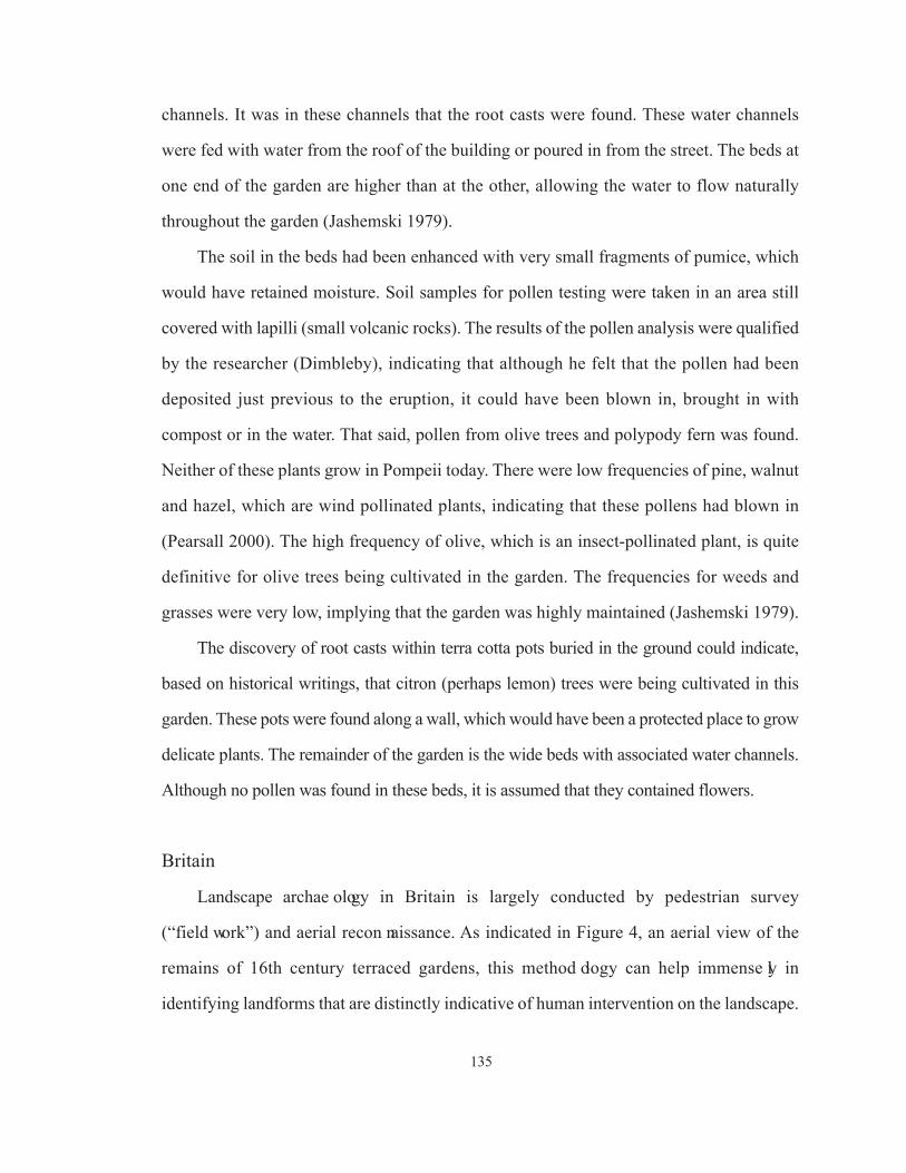
135
channels. It was in these channels that the root casts were found. These water channels
were fed with water from the roof of the building or poured in from the street. The beds at
one end of the garden are higher than at the other, allowing the water to flow naturally
throughout the garden (Jashemski 1979).
The soil in the beds had been enhanced with very small fragments of pumice, which
would have retained moisture. Soil samples for pollen testing were taken in an area still
covered with lapilli (small volcanic rocks). The results of the pollen analysis were qualified
by the researcher (Dimbleby), indicating that although he felt that the pollen had been
deposited just previous to the eruption, it could have been blown in, brought in with
compost or in the water. That said, pollen from olive trees and polypody fern was found.
Neither of these plants grow in Pompeii today. There were low frequencies of pine, walnut
and hazel, which are wind pollinated plants, indicating that these pollens had blown in
(Pearsall 2000). The high frequency of olive, which is an insect-pollinated plant, is quite
definitive for olive trees being cultivated in the garden. The frequencies for weeds and
grasses were very low, implying that the garden was highly maintained (Jashemski 1979).
The discovery of root casts within terra cotta pots buried in the ground could indicate,
based on historical writings, that citron (perhaps lemon) trees were being cultivated in this
garden. These pots were found along a wall, which would have been a protected place to grow
delicate plants. The remainder of the garden is the wide beds with associated water channels.
Although no pollen was found in these beds, it is assumed that they contained flowers.
Britain
Landscape archae o l ogy in Britain is largely conducted by pedestrian survey
(“field work”) and aerial recon naissance. As indicated in Figure 4, an aerial view of the
remains of 16th century terraced gardens, this method ology can help immense ly in
identifying landforms that are distinctly indicative of human intervention on the landscape.

136
Archaeological in vesti gations at Castle Bromwich Hall in 1989-91 were seen as
an opportunity to test several techniques in an historical-period garden setting. The remains
of gardens at this location were primarily 19th century, the same time frame as the HBC
occupation at Fort Vancouver. Surface survey recorded existing buildings and landforms
(Currie:1991:81). Geophysical techniques employed were resistiv ity and magnetometry. Two
areas were tested, the Best Garden, which was a lawn at the time of testing, and the Middle
Terrace, which contained a mix of trees, shrubs and grass. Transects were spaced at one
meter within a 20 m x 20 m square. The survey provided valuable infor mation on large,
well-defined features, but could not sort changes to the garden over time, the readings
becoming confused when features overlapped each other and often not recording features
that were found in later excavations. It is also stated that these techniques could not map
Figure 4. Aerial photo of Medieval “earthworks” and 16th century terraced gardens, evident just below the
ground surface (annotations by author) (Aston 1974:171).
Earthworks
Terraced Garden

137
near-surface features, probably due to root disturbance, and surface features confused the
readings of features below them. Also, at one meter width transects, many garden beds
could be missed entirely. Currie (1991:82) concluded that geophysical survey is of
questionable value for investigating historical gardens.
In reference to excavation technique, Currie (1991:90, 93) advocates small test
trenches, based on an opposition to the destruction of the archaeological record, and the
impossibility, in terms of time and money, of doing large-scale excavations on a landscape.
Narrow trenches were dug stratigraphically, and documented with maps, photography and
field notes. The results of the excavations included finding hard landscaping: drains,
filled-in ponds, gravel paths, planting beds and terraces, and a “complex sequence of
activities over the last 400 years” (Currie 1991:93). Figure 5 illustrates a geometrically
shaped planting bed, possibly used for carpet bedding (color-coordinated schemes of
flowering plants placed close together to create a carpet of flowers), a style that was
extremely popular in Britain in the mid-19th century. Meter sticks in the photo indicate
that this trench is approximately 2 m x 6 m. It is unclear if this is considered a “small”
trench. No description of how
the various aspects of this
landscaping was discerned in
the sediments is provided. As a
conclusion on the value of
excavation, the author states that
it disclosed many garden
attributes that would not have
been known otherwise (Currie
1991:79).
Soil analysis was alsoFigure 5. Excavations exposed 1860s skeleton plan of a
parterre. (Currie 1991:80)

138
conducted at this site. Particle size analysis, which can identify the sources of soils, was of
limited use and provided no valuable information. Phosphate percolation* (used to date
artificial soil constructions, such as banks and terraces), produced incoherent results. The
inference is that mixed soils were used to create the features in the first place. Testing for
pH levels indicated that the natural soils were very low in pH. This would make it extremely
difficult to grow healthy plants. The pH levels in the garden soils were much higher,
indicating that considerable enhancement had taken place (Currie 1991:84). High phosphate
levels (and excavation) indicated that ash and charcoal had been added to the soils. The level
was also sufficiently high to infer that manures and composts had been added. Calcium
levels suggest that the soil was limed to lower the acidity. High levels of magnesium would
also be produced by the addition of charcoal. Gridded sampling strategies for soil analysis
could help to indicate planting beds that have been unrecognizably altered, and the locations
of wooden bed edges that had decomposed (Currie 1991:87).
The soils were tested for both bone and botanical remains. It was considered that the
acidity of the soil would not be conducive to good preservation, but testing indicated that
bone and macrofloral remains were well-preserved. Results of these analyses were pending
at publication (Currie 1991:88). Pollen preservation and contamination were also concerns,
but again, it was concluded that the pollen was surprisingly well-preserved, and frequencies
of various types of pollen were more than adequate to determine those that were
“background contamination” (such as grasses). It was concluded that the site had been
predominantly pasture, with more trees during the medieval period than later. The frequency
of cereal pollen was determined to be too high to be blown in, and it was inferred that it
was brought in on straw, possible contained in the manure. Other pollens identified were
*A review of articles relating to using phosphate analysis to interpret anthropic sediments did not provide any
information on how phosphate percolation could be used to date such sediments. Sjoberg (1976:448) states
that phosophorus analysis was being employed in an attempt to provide relative and absolute dates. The
science behind this method of dating was not provided, nor were any articles found that derived from these
experiments (other than the article above).

139
holly, hazel, walnut, celery and parsley. Plant identifications were limited to genus. The
authors stated that pollen sampling was very valuable to the analysis of historic garden
spaces, particularly considering the limited sampling strategy employed on this project
(Currie 1991:90).
The soils were also dated with optical luminescence. When mineral grains are exposed
to the sun, electrons are trapped in the “lattice” (Currie 1991:91). These electrons are
released when the minerals are heated. The rate of release is measured to determine the last
date of exposure to sunlight, indicating the date of deposition. Samples were taken from
pond and sluice silts. It is not explained why these particular proveniences were appropriate.
Although dates of 10,000 BP were obtained from the samples, indicating that the deposits
had been contaminated by introduced soils, the author indicated that this testing method
has been employed successfully at other sites (Currie 1991:92).
It is indicated that artifact analysis is paticularly valuable in gardens for determining
refuse disposal practices. Areas of this garden were identified as “key” disposal areas,
possibly to enhance the soil (Currie 1991:92). The focus for this analysis on this project
was to provide a chronology for site development, utilizing artifacts such as ceramics. The
results of this analysis are documented elsewhere (Currie 1991:92).
Resistivity and magnetometry testing were also conducted at the gardens at Shibden
Hall, (also a 400-year-old site), in 1995 (Aspinall 1997). Readings were taken at .5 m
intervals across the lawn at the front of the Hall. Anomalies were seen that were inferred
to be metal pipes and stone drains. Possible remains of an orchid house were identified,
and individual areas of high resistance were interpreted to have been tree plantings. The
magnetic survey (Figure 6) picked up the remains of the serpent-shaped flower beds (Figure
7) located at the front of the Hall.

140
As previously stated, there is an abundance of information relating to garden archaeology
in Britain. The investiga tions at Castle Bromwich Hall provide a very good overview of
the possibilities of various forms of testing, while the project at Shibden Hall shows the
value of geophysical testing (in a relatively undisturbed context) to determine excavation
strategies.
Figure 7. 1930s aerial photo showing serpentine-shaped garden beds at front of Shibden Hall (Aspinall
1997:224).
Figure 6. Magnetometer survey showing serpent- and circular-shaped garden beds (Aspinall 1997:226).

141
Eastern United States
Miller and Gleason (1994), in The Archaeology of Garden and Field, provide an
overview of archaeological techniques that have been applied to finding gardens in
primarily colonial sites in the Eastern United States. They state that in the area of the
Chesapeake, archaeologists often use heavy machinery to scrape the surface, exposing post
holes, walks, and planting beds. This technique is not used in the mid-Atlantic, where
gardens are fragmentary aspects of later urban occupations (Miller and Gleason 1994:169).
Gardens that have remained intact, largely due to their proximity to estate homes, were
continuously replanted, often in the new “revival” styles, creating a palimpsest of original
and reused styles. Miller and Gleason note that most archaeological techniques developed
for landscape archaeology by archaeologists such as Kelso at Carter’s Grove and Noel
Hume at Williamsburg cross over into relevance in a garden site (Miller and Gleason
1994:170). However, in gardens, expectations based on the planter’s world view, his
opinions on the place of nature, and his competitiveness with his neighbors must be
included in archaeological research design (Miller and Gleason 1994: 170).
As in the section related to England above, Miller and Gleason advocate remote sensing
as invaluable in determining excavation locations that will generate relatively higher
quantity and quality of data, vital considerations when an often immense area is being
considered for research. Several sites are discussed where the remote sensing results were
disappointing, similarly to Castle Bromwich Hall. Even with these difficulties, Miller and
Gleason advocate this technique as essential, performing better when finding “tree lines,
planting beds and access areas” (Miller and Gleason 1994: 173).
Sub-surface testing methods discussed include (in order of disturbance level):
geologists’s split spoon auger; steel T-probes (which can indicate buried brick paths and
trace building walls); soil cores, post-hole diggers and probes; checkerboard excavation

142
strategy; and trenching (Miller and Gleason 1994:174). The less-disturbing methods would
be followed up with more extensive excavation.
Key to understanding the spatial use of a garden are the determination of the
boundaries, finding the major axes, and determining access (Miller and Gleason 1994:181).
When digging trenches over a large area, it is difficult to determine the vertical relationship
between the strata. Very close controls of vertical distance must be maintained in order to
comment on possible terraces, beds with different uses, and the relationships of features
(Miller and Gleason 1994:186).
Generally, the measurements of formal gardens in the 18th century mirror the proportions
of the house. For example, the width of a rectangular bed may be consistent with the height
of a house. In William Paca’s garden, a 3:4:5 rectangle proportion (based on the perch, a
measurement equaling 16.5 feet) was used. This proportion stems from pre-13th century and
is the basis for the later “rod” length (Nicholson 1912). Geometric dimensions ordered height,
depth and width. Applying this measurement methodology to archaeological research design
will indicate likely areas of emphasis in a garden (Miller and Gleason 1994:195).
Audrey Noel Hume (1974) discusses colonial garden technology employed at
Williamsburg relating to paths and plants. Archaeological testing has indicated that paths
were often paved with a mix of tobacco pipe, glass and ceramic, undoubtedly acting
similarily to adding gravel to the sediments. Heavy rollers of stone or iron were used to
compact, level and smooth surfaces. An 18th century writer, Philip Miller, advocates the
rolling of paths when “it rains so very fast that the walks swim with water” (Noel Hume
1974:25). Figure 8 illustrates a horse drawn roller and water tank, with the path being
watered after rolling. The exact purpose of this technique is not clear, other than perhaps
“melting” the sediments to make them more cohesive with the added elements (gravel,
ceramic, etc.). This technology should be identifiable in archaeological contexts, which
would contain increased frequencies of artifacts, specifically pipe, ceramic and glass,

143
and compacted surfaces.
The well in John Custis’
18th century garden in
Williamsburg was a good source
for identifiable pollen and
macrofloral remains. The
waterlogged contents of the well
provided excellent preservation of pollen, twigs, seeds, fruit and even leaves (Noel Hume
1974:31). Dutch boxwood, planted by Custis according to his correspondence, was
trimmed some forty years after Custis’ death and the clippings thrown into the well. These
clippings were still green when brought to the surface during the excavation of the well
(Noel Hume 1974:31). The analysis of these materials confirmed written documentation
that the garden had contained both native and introduced species, and specifically
identified sixteen plants that Custis had indicated in correspondence were growing in his
garden (Noel Hume 1974:31).
Figure 8. Combination roller, watering equipment (Drower
2001:69).

APPENDIX B
Results of 2005 and 2006 Excavations by Unit
144

145
APPENDIX B Results of 2005 and 2006 Excavations by Unit
Tab
le A
-1. R
esult
s of
2005 a
nd 2
006 E
xca
vat
ions
by U
nit
.

146
Tab
le A
-1. R
esult
s of
2005 a
nd 2
006 E
xca
vat
ions
by U
nit
. (c
onti
nued
)

147
Tab
le A
-1. R
esult
s of
2005 a
nd 2
006 E
xca
vat
ions
by U
nit
. (c
onti
nued
)

APPENDIX C
Archaeological Features Inferred to be Related to the Hudson’s Bay Company
Occupation by Previous Archaeological Testing and Determined to be 20th Century
Occupation by Sub-surface Testing During the HBC Garden Project
148

APPENDIX C
Archaeological Features Inferred to be Related to the Hudson’s Bay Company
Occupation by Previous Archaeological Testing and Determined to be 20th Century
Occupation by Sub-surface Testing During the HBC Garden Project
These features (Feature 505 and Feature 507) have not been included in the text of this
document as they are not related to its focus, the HBC Garden, but rather date to the 20th
Century Army occupation. The two features were found in TA1, which had been inferred to
be an HBC-period well based on anomalies found during ground penetrating radar testing
(Bell 1991). They are included as an Appendix due to the focus that was placed, and resources
that were expended on this location during the planning and execution of this project.
Feature 507, discovered in 2005 and continued with safety-shoring in 2006, was the
southern half of an extensive trash deposit containing corrugated roofing metal, concrete tiles with
red, yellow, and blue paint stains on their surfaces, white porcelain wall tiles, a largely intact toilet,
manufactured by The T.P. Co., Trenton, N.J. patent date 1890, concrete sewer pipe (not used at
this site until the 1930s or 1940s), metal machinery parts, and many other industrial artifacts. Below
the trash deposit were the remains of several large, milled wooden timbers (cribbing) laid at right
angles, creating a square shape (the northern side of the square continued into the north wall of the
trench and the cribbing on the west side had been displaced) with associated wire nails (Figure
B-1). The two visible wooden timbers were 96 cm and 115 cm long, and 30 cm in depth. At a
depth of 144 cmbd, just below the bottom of the wooden cribbing, a complete alcohol bottle was
found, embossed with the text, “Federal Law Forbids Sale or Reuse of This Bottle.” This statement
was embossed on alcohol bottles from 1935 to 1964. This date provides a TPQ for the Feature 507
trash of 1935. The wooden cribbing is likely from a WWI dry well, due to the association of a
french drain (Feature 505) sloping into the area of the cribbing from the east (Figure B-2), with
another possible French drain sloping in from the west (Feature 512). French drains were employed
149

to dispose of waste water at this site during WWI. A shovel test was dug into sediments below the
cribbing (from 199 cmbd to 260 cmbd), showing a 9-10 cm layer of silt and natural C horizon
sediments below the silt, indicating that the feature is not an HBC-period water well.
Figure B-1. Facing north, Feature 507 wooden cribbing. The metal tubes are shoring for the deep excavation.
Photo courtesy of the National Park Service.
WoodCribbing
150

Figure B-2. Facing west, Feature 505 French drain trench, with associated rocks and wood fragments. Feature507 (post-1935 trash deposit and WWI dry well) was found in the excavation units at the center of the trench.Photo courtesy of the National Park Service.
Feature 505
Location of Feature 507
151

152
APPENDIX D
Phytolith Analysis of Samples from Ft. Vancouver National Historic Site, Washington

153

154

155
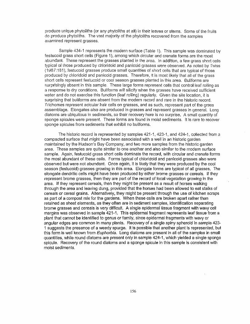
156

157

158

159

160

161
APPENDIX E
Pollen and Phytolith Analysis of a Historic Garden at Fort Vancouver National Historic Site, Vancouver, Washington
161

162

163

164

165

166
167

168

169

170

171

172

173
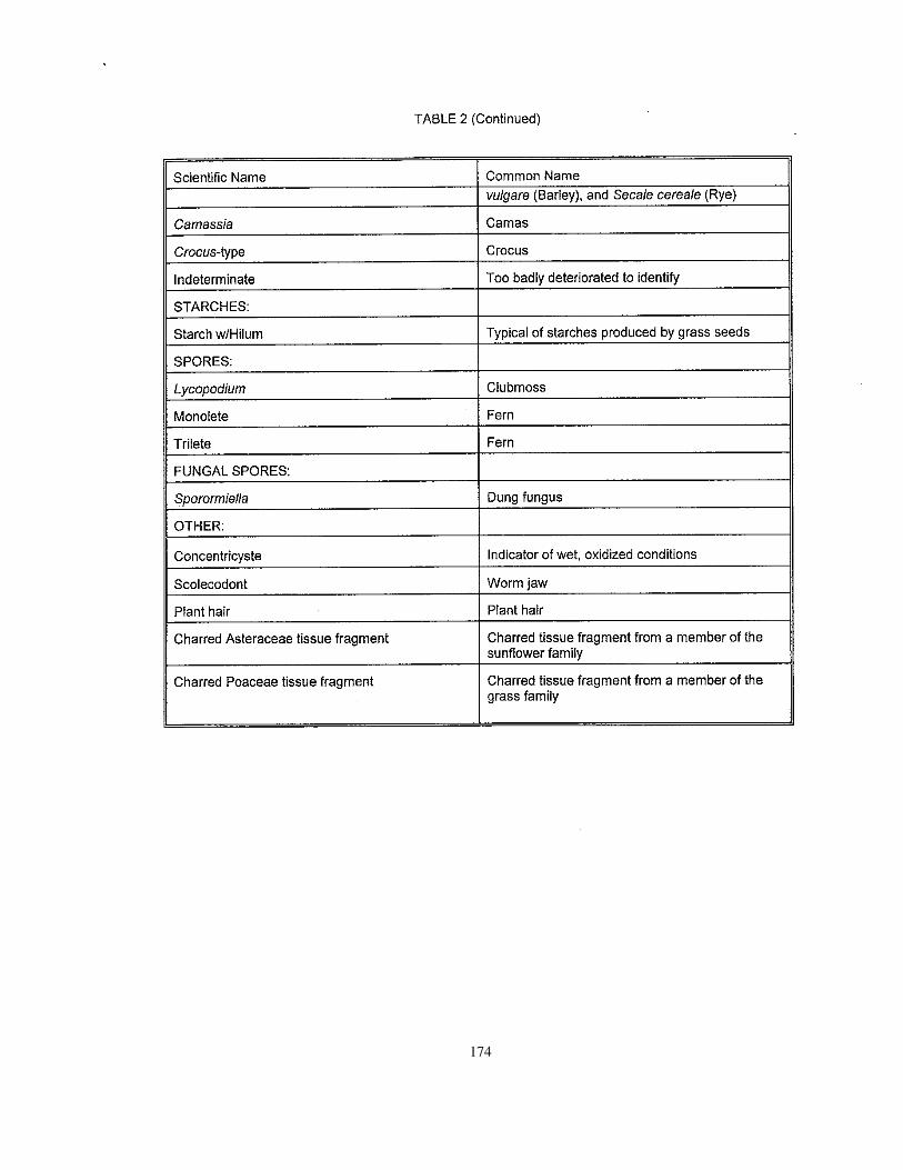
174
175

176
APPENDIX F
An Analysis of Pollen from Fort Vancouver Washington
177

177
January, 2007
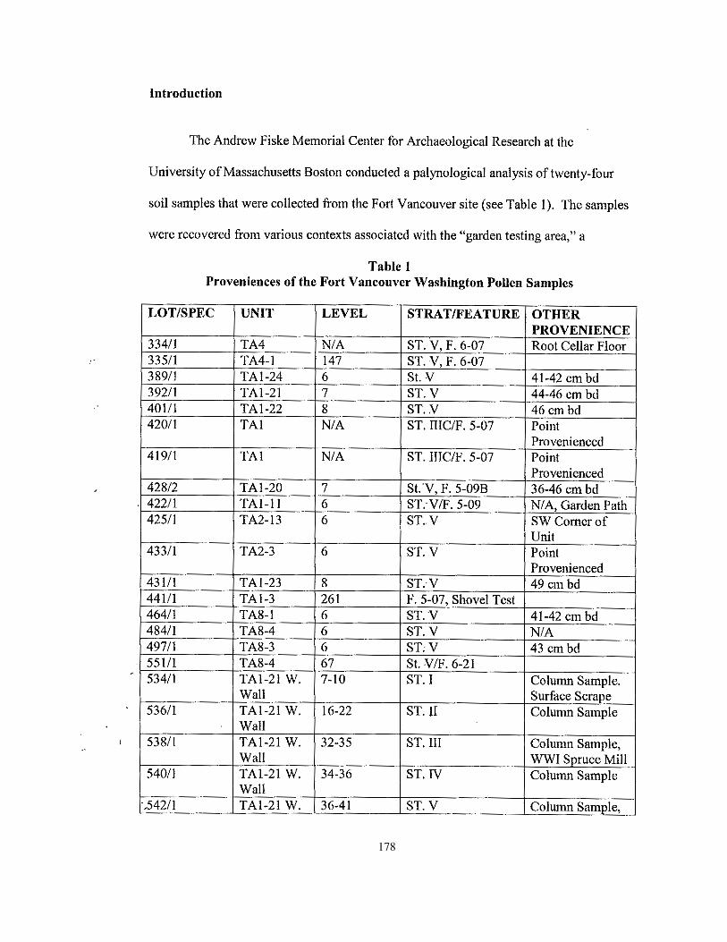
178

179

180
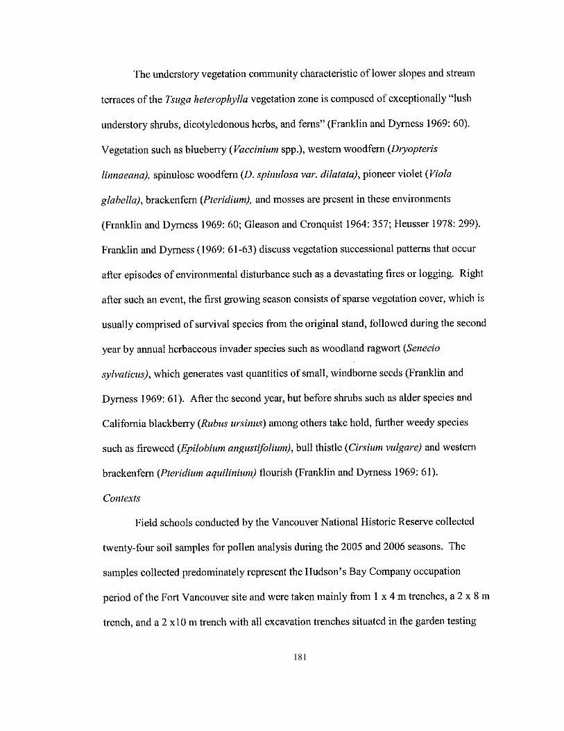
181

182

183

184

185

186
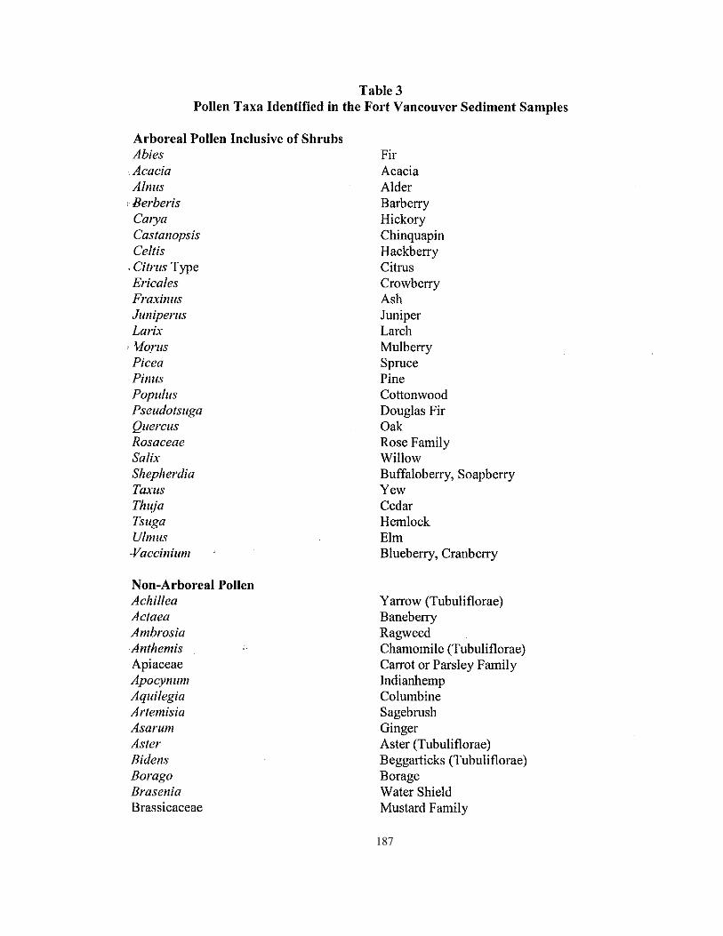
187

188

189

190
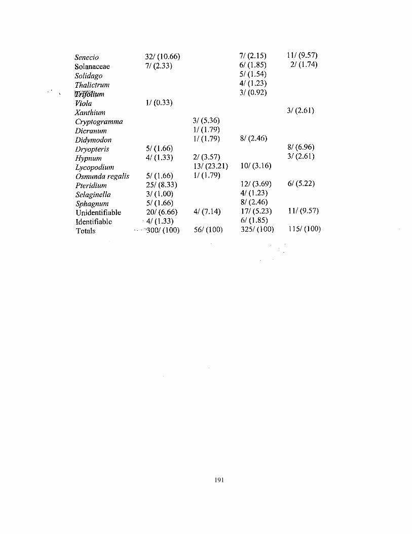
191

192
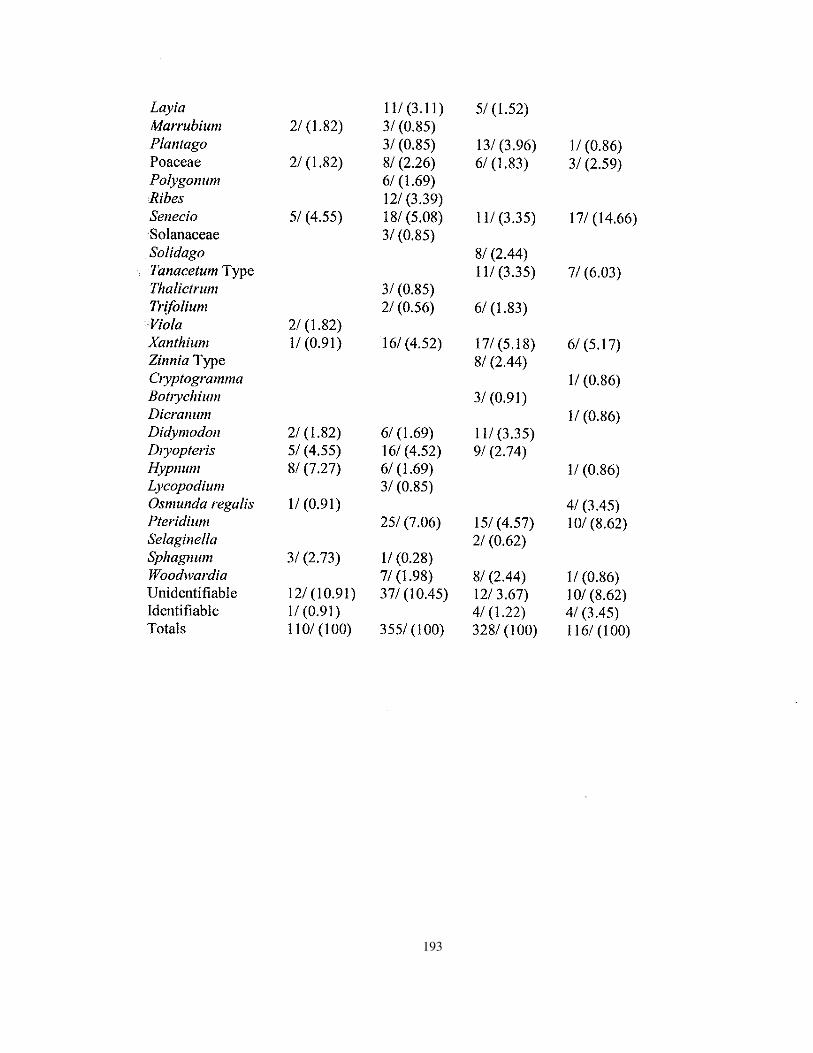
193

194

195

196

197

198

199

200
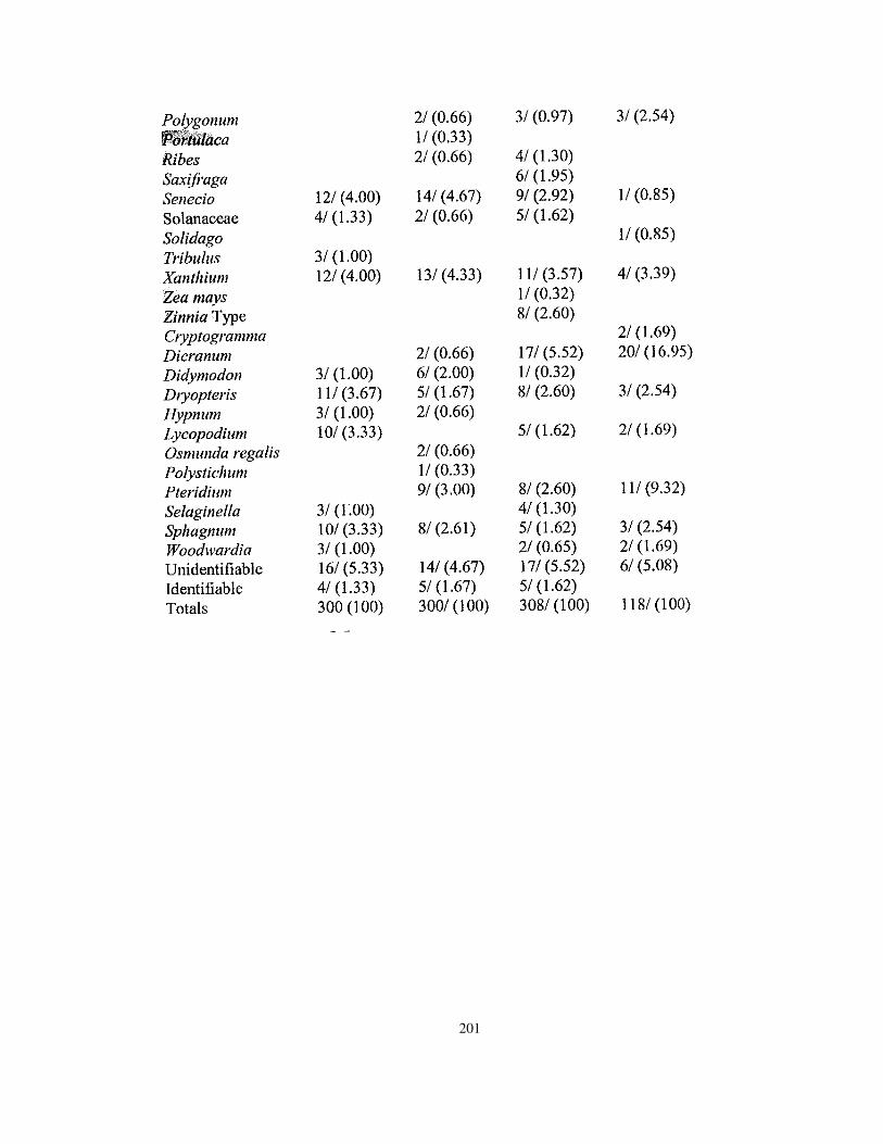
201

202

203

204

205

206

207

208

209

210

211

212

213

214

215
216

217

218

219

220

221

222

223

224
225

226

227

228
229

229

230

231
232

233

234
APPENDIX G
A Pollen Analysis of a Hudson’s Bay Company Non-Garden Provenience, Fort Vancouver, Washington
235

235
236

237
238

239

240

241

242

243

244

245

246

247

248

249

250

251

252
253

254

255

256

257

258

259
260

261

262

263

264

265
266

267

268
269

270

271

272

273

274

275

276

277

278

279

280
APPENDIX H
Macrobotanical Analysis of Hand-picked and WetscreenSamples from Fort Vancouver, Washington
281

281

282

283
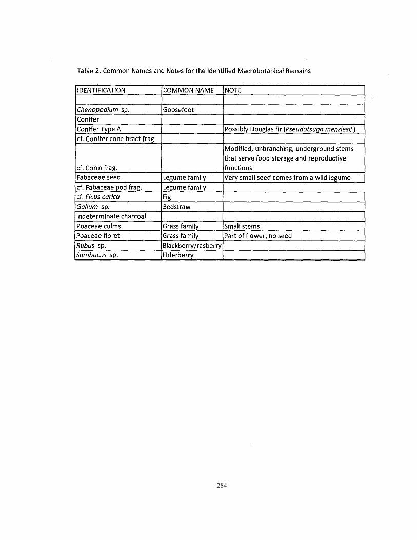
284