Embed Size (px)
Citation preview
Flood Fighting in Manitoba
A History and Background of Manitoba’s Flood Protection Works
1Flood Fighting in Manitoba
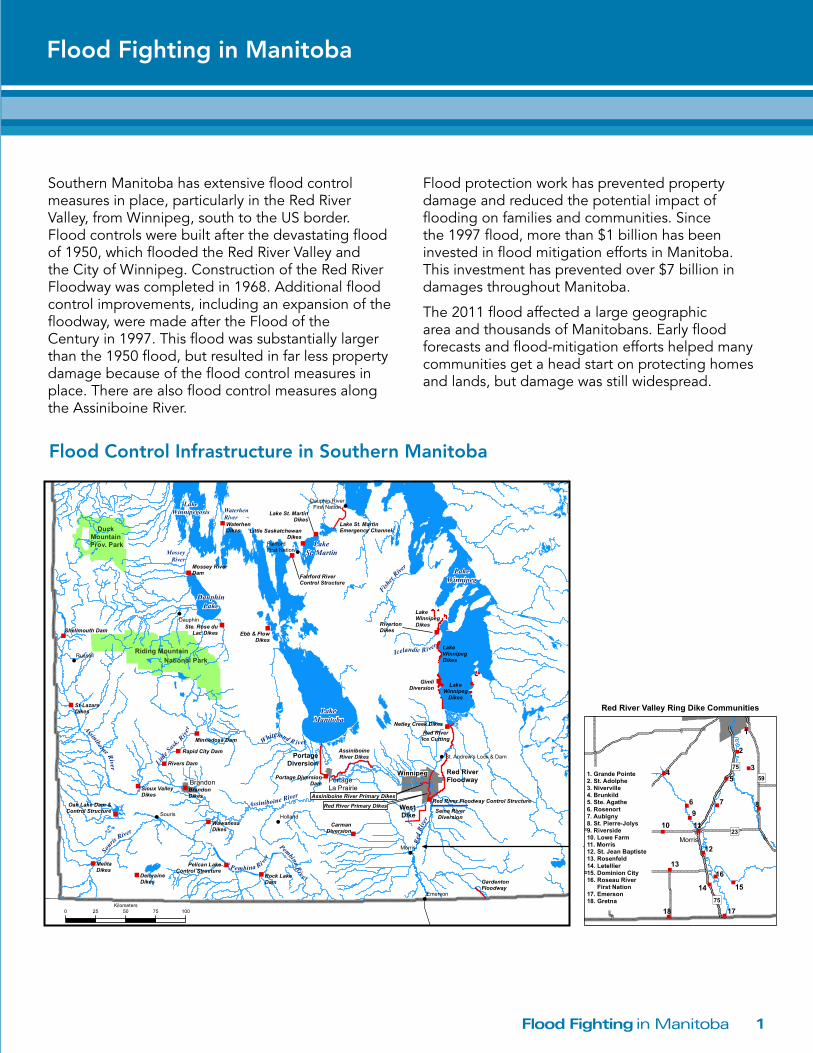
Southern Manitoba has extensive flood control measures in place, particularly in the Red River Valley, from Winnipeg, south to the US border. Flood controls were built after the devastating flood of 1950, which flooded the Red River Valley and the City of Winnipeg. Construction of the Red River Floodway was completed in 1968. Additional flood control improvements, including an expansion of the floodway, were made after the Flood of the Century in 1997. This flood was substantially larger than the 1950 flood, but resulted in far less property damage because of the flood control measures in place. There are also flood control measures along the Assiniboine River.
Flood protection work has prevented property damage and reduced the potential impact of flooding on families and communities. Since the 1997 flood, more than $1 billion has been invested in flood mitigation efforts in Manitoba. This investment has prevented over $7 billion in damages throughout Manitoba.
The 2011 flood affected a large geographic area and thousands of Manitobans. Early flood forecasts and flood-mitigation efforts helped many communities get a head start on protecting homes and lands, but damage was still widespread.
Flood Control Infrastructure in Southern Manitoba
Flood Fighting in Manitoba
"
"
"
"
"
"
"
"
"
"
"
"
"
"
"
"
"
"
"
"
"
!
!
!
!
!
!
!
!
LakeManitoba
LakeWinnipeg
DauphinLake
LakeSt. Martin
Riding Mountain
Duck Mountain Prov. Park
LakeWinnipegosis
Sour
is River
Assiniboine River Little S
ask. R
iver
Whitemud R iver
MosseyRiver
WaterhenRiver
Assiniboine River
Red
Rive
r
BrandonWinnipeg
PortageLa Prairie
National Park
PortageDiversion
WestDike
Red RiverFloodway
Ste. Rose duLac Dikes
Fairford RiverControl Structure
Lake St. MartinEmergency Channel
AssiniboineRiver Dikes
Red RiverIce Cutting
Seine RiverDiversion
Fisher
River
Netley Creek Dikes
Mossey RiverDam
Red River Primary Dikes
Assiniboine River Primary Dikes
Pembina Ri ver
Portage DiversionDam
GardentonFloodway
Little SaskatchewanDikes
Ebb & FlowDikes
Lake St. MartinDikes
Souris!
LakeWinnipeg
Dikes
LakeWinnipegDikes
LakeWinnipegDikesRiverton
Dikes
Icelandic River
Pembina Riv e r
St. Andrew's Lock & Dam
Dauphin
Morris
Russell
Holland
Emerson
FairfordFirst Nation
Dauphin RiverFirst Nation
GimliDiversion
CarmanDiversion
Rock LakeDam
Shellmouth Dam
Red River Floodway Control Structure
Pelican LakeControl Structure
Rivers Dam
Oak Lake Dam &Control Structure
Minnedosa Dam
Rapid City Dam
MelitaDikes
BrandonDikes
WawanesaDikes
WaterhenDikes
St-LazareDikes
DeloraineDikes
Sioux ValleyDikes
"
"
"
"
"
"
"
"
" "
"
"
"
"
"
"
"
"
1
2
345
6 7 89
10 11
12
13
14 15
16
17180 25 50 75 100Kilometers
FLOOD CONTROLINFRASTRUCTURE
INSOUTHERN MANITOBA
")75
")75
Morris
")59
")23
Red River Valley Ring Dike Communities
1. Grande Pointe2. St. Adolphe3. Niverville4. Brunkild5. Ste. Agathe6. Rosenort7. Aubigny8. St. Pierre-Jolys9. Riverside10. Lowe Farm11. Morris12. St. Jean Baptiste13. Rosenfeld14. Letellier15. Dominion City16. Roseau River First Nation17. Emerson18. Gretna
"
"
"
"
"
"
"
"
"
"
"
"
"
"
"
"
"
"
"
"
"
!
!
!
!
!
!
!
!
LakeManitoba
LakeWinnipeg
DauphinLake
LakeSt. Martin
Riding Mountain
Duck Mountain Prov. Park
LakeWinnipegosis
Sour
is River
Assiniboine River Little S
ask. R
iver
Whitemud R iver
MosseyRiver
WaterhenRiver
Assiniboine River
Red
Rive
r
BrandonWinnipeg
PortageLa Prairie
National Park
PortageDiversion
WestDike
Red RiverFloodway
Ste. Rose duLac Dikes
Fairford RiverControl Structure
Lake St. MartinEmergency Channel
AssiniboineRiver Dikes
Red RiverIce Cutting
Seine RiverDiversion
Fisher
River
Netley Creek Dikes
Mossey RiverDam
Red River Primary Dikes
Assiniboine River Primary Dikes
Pembina Ri ver
Portage DiversionDam
GardentonFloodway
Little SaskatchewanDikes
Ebb & FlowDikes
Lake St. MartinDikes
Souris!
LakeWinnipeg
Dikes
LakeWinnipegDikes
LakeWinnipegDikesRiverton
Dikes
Icelandic River
Pembina Riv e r
St. Andrew's Lock & Dam
Dauphin
Morris
Russell
Holland
Emerson
FairfordFirst Nation
Dauphin RiverFirst Nation
GimliDiversion
CarmanDiversion
Rock LakeDam
Shellmouth Dam
Red River Floodway Control Structure
Pelican LakeControl Structure
Rivers Dam
Oak Lake Dam &Control Structure
Minnedosa Dam
Rapid City Dam
MelitaDikes
BrandonDikes
WawanesaDikes
WaterhenDikes
St-LazareDikes
DeloraineDikes
Sioux ValleyDikes
"
"
"
"
"
"
"
"
" "
"
"
"
"
"
"
"
"
1
2
345
6 7 89
10 11
12
13
14 15
16
17180 25 50 75 100Kilometers
FLOOD CONTROLINFRASTRUCTURE
INSOUTHERN MANITOBA
")75
")75
Morris
")59
")23
Red River Valley Ring Dike Communities
1. Grande Pointe2. St. Adolphe3. Niverville4. Brunkild5. Ste. Agathe6. Rosenort7. Aubigny8. St. Pierre-Jolys9. Riverside10. Lowe Farm11. Morris12. St. Jean Baptiste13. Rosenfeld14. Letellier15. Dominion City16. Roseau River First Nation17. Emerson18. Gretna
Flood Fighting in Manitoba2
TOP TEN MANITOBA FLOODS SINCE 1800Red River at James Avenue, Winnipeg
NATURAL SPRING PEAK DISCHARGES IN CUBIC FEET PER SECOND (1000s)Red River at James Avenue, Winnipeg
NATURAL SPRING PEAK STAGES IN FEET ABOVE DATUMRed River at James Avenue, Winnipeg
250
200
150
100
50
0
225,000
36.5’
1826
108,000
30.3’
*1996
108,000
30.3’
*1979
125,000
32.2’
1861
128,000
*2009
32.5’
108,000
30.3’
1950
*2011
165,000
34.5’
1852
163,000
34.4’
*1997
99,000
28.5’
*2006
116,000
31.2’
* Computed Natural Discharge Without Use Of Red River Floodway, Portage Diversion, Shellmouth Dam Compiled by Manitoba Conservation and Water Stewardship
10,000
20,000
30,000
40,000
50,000
60,000
70,000
0*1975*1996*2009*1974*1995*2011 190219041882 *1976
* Computed discharge without the use of Shellmouth reservoir as computed by Manitoba Conservation and Water Stewardship
INFLOW TO PORTAGE RESERVOIR WITHOUT SHELLMOUTH RESERVOIR REGULATION
TOP 10 ASSINIBOINE RIVER FLOODS SINCE 1880sAssiniboine River at Portage la Prairie
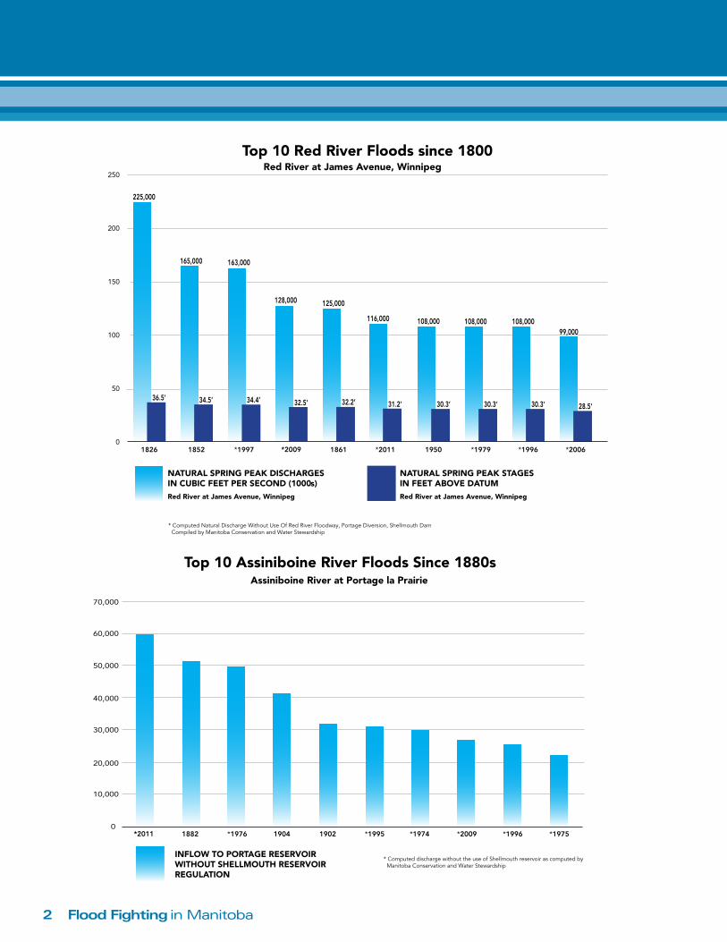
Top 10 Red River Floods since 1800
Top 10 Assiniboine River Floods Since 1880s
3Flood Fighting in Manitoba
2,800
28,000
100,000
0
20,000
40,000
60,000
80,000
100,000
120,000
900279910591
Year of Flood
Eva
cuee
s
7,100
2011
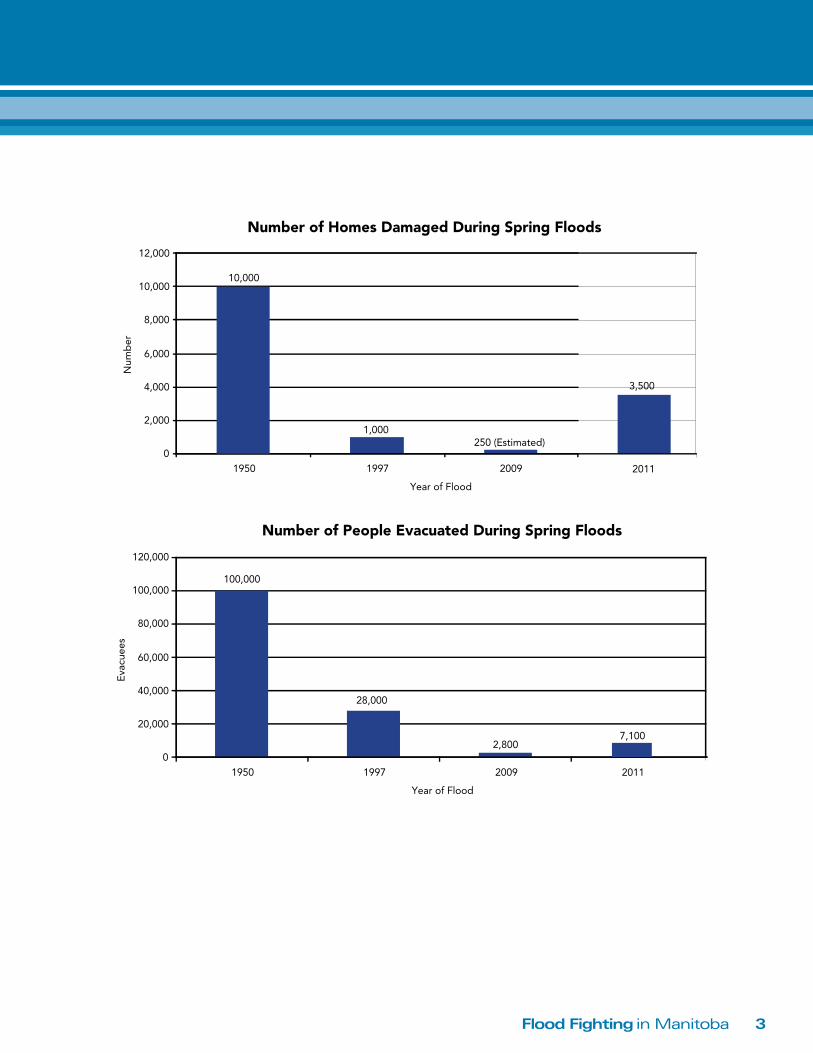
Number of People Evacuated During Spring Floods
2,800
28,000
100,000
0
20,000
40,000
60,000
80,000
100,000
120,000
900279910591
Year of Flood
Eva
cuee
s
7,100
2011
Number of People Evacuated During Spring Floods
10,000
250 (Estimated)1,000
0
2,000
4,000
6,000
8,000
10,000
12,000
900279910591
Year of Flood
Num
ber
1102
3,500
Number of Homes Damaged During Spring Floods
Flood Fighting in Manitoba4
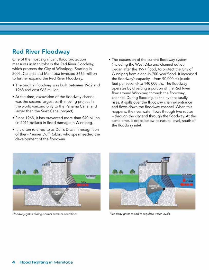
Red River FloodwayOne of the most significant flood protection measures in Manitoba is the Red River Floodway, which protects the City of Winnipeg. Starting in 2005, Canada and Manitoba invested $665 million to further expand the Red River Floodway.
•Theoriginalfloodwaywasbuiltbetween1962and1968 and cost $63 million.
•Atthetime,excavationofthefloodwaychannelwas the second largest earth moving project in the world (second only to the Panama Canal and larger than the Suez Canal project).
•Since1968,ithaspreventedmorethan$40billion(in 2011 dollars) in flood damage in Winnipeg.
•ItisoftenreferredtoasDuff’sDitchinrecognitionofthen-PremierDuffRoblin,whospearheadedthedevelopment of the floodway.
•Theexpansionofthecurrentfloodwaysystem(includingtheWestDikeandchanneloutlet)began after the 1997 flood, to protect the City of Winnipegfromaone-in-700-yearflood.Itincreasedthefloodway’scapacity–from90,000cfs(cubicfeetpersecond)to140,000cfs.Thefloodwayoperates by diverting a portion of the Red River flow around Winnipeg through the floodway channel.Duringflooding,astherivernaturallyrises, it spills over the floodway channel entrance and flows down the floodway channel. When this happens, the river water flows through two routes –throughthecityandthroughthefloodway.Atthesame time, it drops below its natural level, south of the floodway inlet.
Floodway gates during normal summer conditions Floodway gates raised to regulate water levels
5Flood Fighting in Manitoba
•Whenthefloodwaygatesareraised,thewaterlevel south of the floodway inlet is restored to its natural level which, in turn, allows more water to spill into the floodway. As Red River flows continue to increase, the level south of the inlet drops below natural again and the gates are raised further. This process continues as long as the flow in the Red River continues to increase.
•Duringthemajorityoffloods,thefloodwayisoperated to ensure that the water level south of the cityismaintainedatthenaturallevel–thatisthelevel that would occur if the flood control works did not exist.
•Inamajorflood,evenlargerthan1997,theflowthrough the city will be controlled with the guidance of three spring floodway operating rules. These rulesaredesignedtoensureWinnipeg’sprimarydiking system is not overwhelmed. When these rules are implemented to protect the city, there may be instances when additional water going through the floodway causes artificial flooding of land and roadssouthofthefloodwayinlet.Inrecognitionof this possibility, the Manitoba government has legislation in place which provides compensation to individuals impacted by this artificial flooding.
•Afourthfloodwayoperatingruleisalsoinplace,butis only applied during the summer when high water levelsaffectWinnipeg’sstormsewerandcombinedsewer systems. The combination of high water and a high intensity rain storm can overwhelm the sewer systemscausingbasementflooding.Ifthisoccurs,operation of the floodway can lower water levels in the city, reducing the damages and potential health risk caused by basement flooding.
•ThefloodwayisrecognizedasaNationalHistoricCivil Engineering Site and is considered one of theworld’s16engineeringmarvels.Formoreinformation, see www.floodwayauthority.mb.ca.
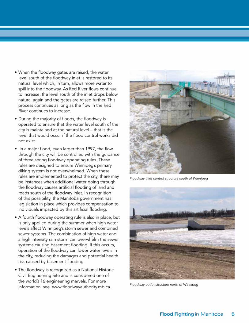
Floodway inlet control structure south of Winnipeg
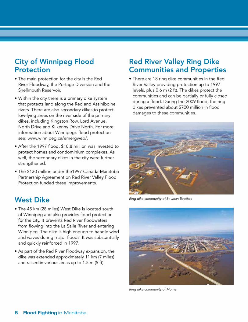
Floodway outlet structure north of Winnipeg
Flood Fighting in Manitoba6
City of Winnipeg Flood Protection•ThemainprotectionforthecityistheRedRiverFloodway,thePortageDiversionandtheShellmouth Reservoir.
•Withinthecitythereisaprimarydikesystemthat protects land along the Red and Assiniboine rivers. There are also secondary dikes to protect low-lying areas on the river side of the primary dikes, including Kingston Row, Lord Avenue, NorthDriveandKilkennyDriveNorth.FormoreinformationaboutWinnipeg’sfloodprotectionsee: www.winnipeg.ca/emergweb/.
•Afterthe1997flood,$10.8millionwasinvestedtoprotect homes and condominium complexes. As well, the secondary dikes in the city were further strengthened.
•The$130millionunderthe1997Canada-ManitobaPartnership Agreement on Red River Valley Flood Protection funded these improvements.
West Dike•The45km(28miles)WestDikeislocatedsouth
of Winnipeg and also provides flood protection forthecity.ItpreventsRedRiverfloodwatersfrom flowing into the La Salle River and entering Winnipeg. The dike is high enough to handle wind andwavesduringmajorfloods.Itwassubstantiallyand quickly reinforced in 1997.
•AspartoftheRedRiverFloodwayexpansion,thedike was extended approximately 11 km (7 miles) and raised in various areas up to 1.5 m (5 ft).
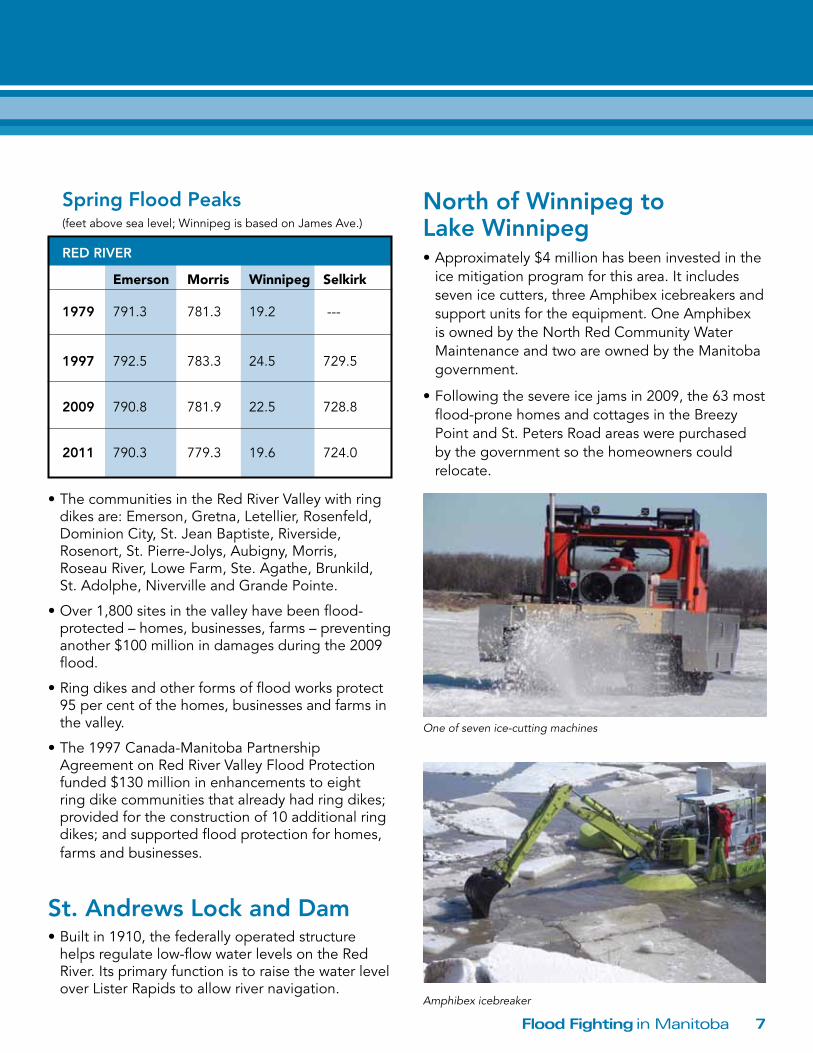
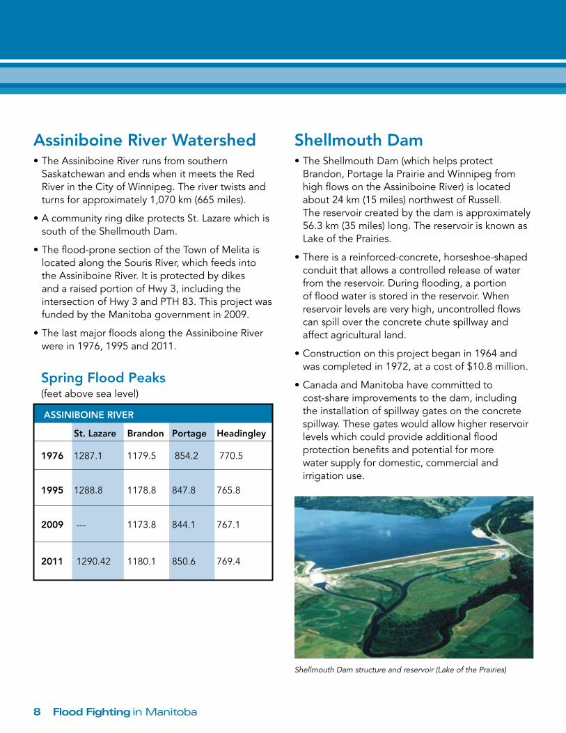
Red River Valley Ring Dike Communities and Properties•Thereare18ringdikecommunitiesintheRed
River Valley providing protection up to 1997 levels, plus 0.6 m (2 ft). The dikes protect the communities and can be partially or fully closed duringaflood.Duringthe2009flood,theringdikes prevented about $700 million in flood damages to these communities.
Ring dike community of St. Jean Baptiste
Ring dike community of Morris
7Flood Fighting in Manitoba
•ThecommunitiesintheRedRiverValleywithringdikes are: Emerson, Gretna, Letellier, Rosenfeld, DominionCity,St.JeanBaptiste,Riverside,Rosenort,St.Pierre-Jolys,Aubigny,Morris, RoseauRiver,LoweFarm,Ste.Agathe,Brunkild,St.Adolphe,NivervilleandGrandePointe.
•Over1,800sitesinthevalleyhavebeenflood-protected–homes,businesses,farms–preventinganother $100 million in damages during the 2009 flood.
•Ringdikesandotherformsoffloodworksprotect95 per cent of the homes, businesses and farms in the valley.
•The1997Canada-ManitobaPartnershipAgreement on Red River Valley Flood Protection funded $130 million in enhancements to eight ring dike communities that already had ring dikes; provided for the construction of 10 additional ring dikes; and supported flood protection for homes, farms and businesses.
St. Andrews Lock and Dam•Builtin1910,thefederallyoperatedstructure
helps regulate low-flow water levels on the Red River.Itsprimaryfunctionistoraisethewaterlevelover Lister Rapids to allow river navigation.
North of Winnipeg to Lake Winnipeg•Approximately$4millionhasbeeninvestedintheicemitigationprogramforthisarea.Itincludesseven ice cutters, three Amphibex icebreakers and support units for the equipment. One Amphibex isownedbytheNorthRedCommunityWaterMaintenance and two are owned by the Manitoba government.
•Followingthesevereicejamsin2009,the63mostflood-pronehomesandcottagesintheBreezyPoint and St. Peters Road areas were purchased by the government so the homeowners could relocate.
Spring Flood Peaks (feetabovesealevel;WinnipegisbasedonJamesAve.)
ReD RiVeR
Emerson Morris Winnipeg Selkirk
1979 791.3 781.3 19.2 ---
1997 792.5 783.3 24.5 729.5
2009 790.8 781.9 22.5 728.8
2011 790.3 779.3 19.6 724.0
One of seven ice-cutting machines
Amphibex icebreaker
Flood Fighting in Manitoba8
Assiniboine River Watershed•TheAssiniboineRiverrunsfromsouthern
Saskatchewan and ends when it meets the Red River in the City of Winnipeg. The river twists and turns for approximately 1,070 km (665 miles).
•AcommunityringdikeprotectsSt.LazarewhichissouthoftheShellmouthDam.
•Theflood-pronesectionoftheTownofMelitaislocated along the Souris River, which feeds into theAssiniboineRiver.ItisprotectedbydikesandaraisedportionofHwy3,includingtheintersectionofHwy3andPTH83.Thisprojectwasfunded by the Manitoba government in 2009.
•ThelastmajorfloodsalongtheAssiniboineRiverwere in 1976, 1995 and 2011.
Shellmouth Dam•TheShellmouthDam(whichhelpsprotectBrandon,PortagelaPrairieandWinnipegfromhigh flows on the Assiniboine River) is located about24km(15miles)northwestofRussell. The reservoir created by the dam is approximately 56.3 km (35 miles) long. The reservoir is known as Lake of the Prairies.
•Thereisareinforced-concrete,horseshoe-shapedconduit that allows a controlled release of water fromthereservoir.Duringflooding,aportionof flood water is stored in the reservoir. When reservoir levels are very high, uncontrolled flows can spill over the concrete chute spillway and affect agricultural land.
•Constructiononthisprojectbeganin1964andwas completed in 1972, at a cost of $10.8 million.
•CanadaandManitobahavecommittedto cost-share improvements to the dam, including the installation of spillway gates on the concrete spillway. These gates would allow higher reservoir levels which could provide additional flood protection benefits and potential for more water supply for domestic, commercial and irrigation use.
Spring Flood Peaks (feet above sea level)
ASSiNiboiNe RiVeR
St. Lazare brandon Portage Headingley
1976 1287.1 1179.5 854.2 770.5
1995 1288.8 1178.8 847.8 765.8
2009 --- 1173.8 844.1 767.1
2011 1290.42 1180.1 850.6 769.4
Shellmouth Dam structure and reservoir (Lake of the Prairies)
9Flood Fighting in Manitoba
City of brandon•TheAssiniboineRiverflowsthroughthenorthernendoftheCityofBrandon.Mostofthedevelopedareas of the city are located on the higher elevations outside of the Assiniboine River Valley floodplain.However,someindustrial,commercial,residential and recreational properties and facilities exist within the floodplain, most notably theBrandonFlatsarea,locatedsouthoftheriverbetween First Street and 26th Street.
•Theflood-pronepropertiesareprotectedbydikesto varying degrees. Prior to the 2011 flood, the CityofBrandonraisedapproximately5km (3.1 miles) of dike by about 0.6 m (2 ft), to a levelabout0.3m(1ft.)abovetheJanuaryandFebruary 2011 flood outlooks. The Manitoba government committed to funding enhancements to permanently raise the level of protection to a one-in-300-year event.
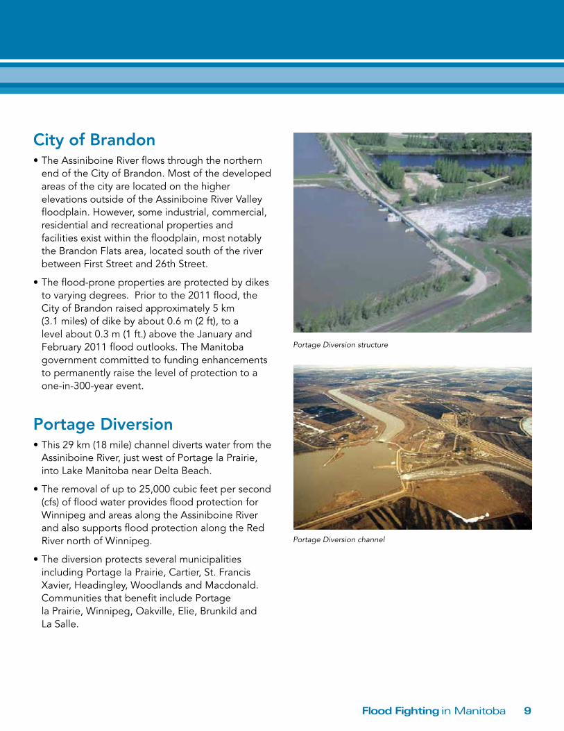
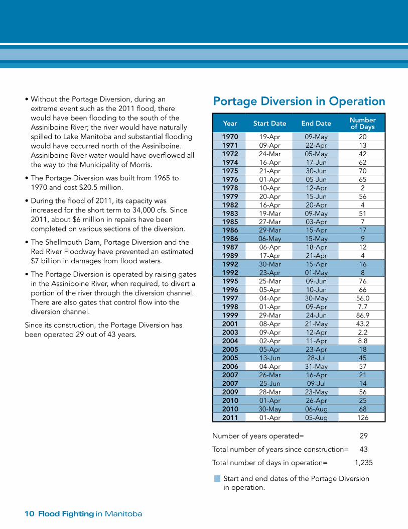
Portage Diversion•This29km(18mile)channeldivertswaterfromthe
Assiniboine River, just west of Portage la Prairie, intoLakeManitobanearDeltaBeach.
•Theremovalofupto25,000cubicfeetpersecond(cfs) of flood water provides flood protection for Winnipeg and areas along the Assiniboine River and also supports flood protection along the Red River north of Winnipeg.
•Thediversionprotectsseveralmunicipalitiesincluding Portage la Prairie, Cartier, St. Francis Xavier,Headingley,WoodlandsandMacdonald.Communities that benefit include Portage laPrairie,Winnipeg,Oakville,Elie,Brunkildand La Salle.
Portage Diversion structure
Portage Diversion channel
Flood Fighting in Manitoba10
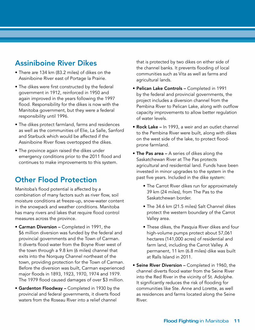
Year Start Date End Date Number of Days
1970 19-Apr 09-May 201971 09-Apr 22-Apr 131972 24-Mar 05-May 421974 16-Apr 17-Jun 621975 21-Apr 30-Jun 701976 01-Apr 05-Jun 651978 10-Apr 12-Apr 21979 20-Apr 15-Jun 561982 16-Apr 20-Apr 41983 19-Mar 09-May 511985 27-Mar 03-Apr 71986 29-Mar 15-Apr 171986 06-May 15-May 91987 06-Apr 18-Apr 121989 17-Apr 21-Apr 41992 30-Mar 15-Apr 161992 23-Apr 01-May 81995 25-Mar 09-Jun 761996 05-Apr 10-Jun 661997 04-Apr 30-May 56.01998 01-Apr 09-Apr 7.71999 29-Mar 24-Jun 86.92001 08-Apr 21-May 43.22003 09-Apr 12-Apr 2.22004 02-Apr 11-Apr 8.82005 05-Apr 23-Apr 182005 13-Jun 28-Jul 452006 04-Apr 31-May 572007 26-Mar 16-Apr 212007 25-Jun 09-Jul 142009 28-Mar 23-May 562010 01-Apr 26-Apr 252010 30-May 06-Aug 682011 01-Apr 05-Aug 126
Numberofyearsoperated= 29
Totalnumberofyearssinceconstruction= 43
Totalnumberofdaysinoperation= 1,235
•WithoutthePortageDiversion,duringanextreme event such as the 2011 flood, there would have been flooding to the south of the Assiniboine River; the river would have naturally spilled to Lake Manitoba and substantial flooding would have occurred north of the Assiniboine. Assiniboine River water would have overflowed all the way to the Municipality of Morris.
•ThePortageDiversionwasbuiltfrom1965to1970 and cost $20.5 million.
•Duringthefloodof2011,itscapacitywasincreasedfortheshorttermto34,000cfs.Since2011, about $6 million in repairs have been completed on various sections of the diversion.
•TheShellmouthDam,PortageDiversionandtheRed River Floodway have prevented an estimated $7 billion in damages from flood waters.
•ThePortageDiversionisoperatedbyraisinggatesin the Assiniboine River, when required, to divert a portion of the river through the diversion channel. There are also gates that control flow into the diversion channel.
Sinceitsconstruction,thePortageDiversionhasbeenoperated29outof43years.
Portage Diversion in operation
StartandenddatesofthePortageDiversionin operation.
11Flood Fighting in Manitoba
Assiniboine River Dikes•Thereare134km(83.2miles)ofdikesonthe
Assiniboine River east of Portage la Prairie.
•Thedikeswerefirstconstructedbythefederalgovernment in 1912, reinforced in 1950 and again improved in the years following the 1997 flood. Responsibility for the dikes is now with the Manitoba government, but they were a federal responsibility until 1996.
•Thedikesprotectfarmland,farmsandresidencesas well as the communities of Elie, La Salle, Sanford and Starbuck which would be affected if the Assiniboine River flows overtopped the dikes.
•Theprovinceagainraisedthedikesunderemergency conditions prior to the 2011 flood and continues to make improvements to this system.
other Flood Protection Manitoba’sfloodpotentialisaffectedbyacombination of many factors such as river flow, soil moisture conditions at freeze-up, snow-water content in the snowpack and weather conditions. Manitoba has many rivers and lakes that require flood control measures across the province.
•Carman Diversion – Completed in 1991, the $6 million diversion was funded by the federal and provincial governments and the Town of Carman. ItdivertsfloodwaterfromtheBoyneRiverwestofthe town through a 9.8 km (6 miles) channel that exitsintotheNorquayChannelnortheastofthetown, providing protection for the Town of Carman. Beforethediversionwasbuilt,Carmanexperiencedmajorfloodsin1893,1923,1970,1974and1979.The 1979 flood caused damages of over $3 million.
•Gardenton Floodway – Completed in 1930 by the provincial and federal governments, it diverts flood waters from the Roseau River into a relief channel
that is protected by two dikes on either side of thechannelbanks.Itpreventsfloodingoflocalcommunities such as Vita as well as farms and agricultural lands.
•Pelican Lake Controls – Completed in 1991 by the federal and provincial governments, the project includes a diversion channel from the Pembina River to Pelican Lake, along with outflow capacity improvements to allow better regulation of water levels.
•Rock Lake –In1993,aweirandanoutletchannelto the Pembina River were built, along with dikes on the west side of the lake, to protect flood-prone farmland.
•The Pas area – A series of dikes along the Saskatchewan River at The Pas protects agricultural and residential land. Funds have been invested in minor upgrades to the system in the pastfiveyears.Includedinthedikesystem:
•TheCarrotRiverdikesrunforapproximately39km(24miles),fromThePastotheSaskatchewan border.
•The34.6km(21.5miles)SaltChanneldikesprotect the western boundary of the Carrot Valley area.
•Thesedikes,thePasquiaRiverdikesandfourhigh-volume pumps protect about 57,061 hectares(141,000acres)ofresidentialandfarm land, including the Carrot Valley. A permanent, 11 km (6.8 miles) dike was built atRallsIslandin2011.
•Seine River Diversion – Completed in 1960, the channel diverts flood water from the Seine River into the Red River in the vicinity of St. Adolphe. Itsignificantlyreducestheriskoffloodingforcommunities like Ste. Anne and Lorette, as well as residences and farms located along the Seine River.
Flood Fighting in Manitoba12
•Ste. Rose du Lac – A diking system was built to protect the town following damage from the 1975 flood. The 1986 flood overtopped these dikes so the federal, provincial and local governments upgradedtheexistingstructures.Newdikesandother infrastructure were also built. All the works cost $2.75 million. They protect against a one-in-100-year flood on the Turtle River.
Lake Winnipeg •Thelakeisthe11thlargestfreshwaterlakein
the world. There are numerous seasonal and permanent cottage and beach communities along thesouthbasinanditsupportsa$40millionannual fishery.
•Inthesummerof1974,approximately100km(62 miles) of dikes were built by the Manitoba government and local communities in response to the threat of high Lake Winnipeg levels.
•In2005,inresponsetolakelevelsthatwerethehighestsince1974,severallocalgovernmentsdeclared states of local emergency and requested help to finance the construction of dikes along Lake Winnipeg, to protect against high lake levels andwindstorms.Between2005and2007,theManitoba government invested $12 million to build 50 km (31 miles) of dikes.
•Amassivestorm(alsoknownasaweatherbomb)on October 27, 2010 significantly damaged parts of these dikes and caused some flooding and property damage along the south basin of Lake Winnipeg.ADisasterFinancialAssistance(DFA)program was established to help with the repair costs of storm damage to residential properties and municipal structures.
•Additionalfloodprotectionalongthelakeincludesthe Gimli diversion, which was completed in 1995. The diversion channels spring melt waters away
from the Town of Gimli and the residential and industrial park in the RM of Gimli, including Loni andSouthBeaches.
•ThelakealsoservesasareservoirforManitobaHydro.ManitobaHydrohasimprovedtheoutletchannel capacity by 50 per cent, building 13 km (8 miles) and 3.2 km (2 miles) channels to reduce flood damage to properties around Lake Winnipeg. For more information see www.gov.mb.ca/waterstewardship/licensing/lake_wpg_regulation.html.
Lake St. Martin/Lake Manitoba•Fairford Dam – A new dam, built in 1961, replacedanoldstructurefirstbuiltin1934.Itregulates water levels of Lake Manitoba and flows intoLakeSt.MartinandtheDauphinRiver.
•Duetounprecedentedfloodingin2011,anemergency outlet channel was built to drain flood water from Lake St. Martin and Lake Manitoba into Lake Winnipeg. Lake Manitoba drains through the Fairford Channel into Lake St. Martin and Lake St. MartindrainsintoLakeWinnipegviatheDauphinRiver.
•ExploratoryworkforpossiblechannellocationsstartedJuly4,2011,andthe6.5km(4miles)outletopenedonNovember1,2011.ThechannelwasclosedinNovember2012asrequiredunderthe federal terms and conditions for emergency operations.
•Morethan130workersandover100piecesof heavy equipment were involved in this construction project. Once the project was finished,theFairfordDamstructurewasabletoremain open through the winter, which helped lower the Lake Manitoba water levels and resulted in lower levels on Lake St. Martin.
13Flood Fighting in Manitoba
The province works closely with Manitoba municipalities to plan and prepare for potential spring flooding.
Flood Fighting equipmentManitoba has invested in a variety of flood fighting equipment, ranging from heavy equipment to specialized dikes and water barriers and has an inventory of temporary flood response equipment such as tiger dams and aqua dams:
•fourAmphibexicebreakers,includingoneownedbytheNorthRedCommunityWaterMaintenanceOrganization
•sevenice-cuttingmachines
•sixArgoamphibiousATVSandsixtrailers
•twomillionregularsandbags
•sixprovincialsandbaggingmachines
•17,000supersandbags
•43km(26miles)ofHescocagebarriers
•61heavy-dutysteamers
•34mobilepumps
•50kmofwater-filledbarriersofwhich22kmareinrapid-response trailers
Flood Fighting in Manitoba14
Manitoba has a strong emergency response plan that includes all municipalities and has been well-tested and implemented in previous flood emergencies.
•ManitobaEmergencyMeasuresOrganization(EMO)is the provincial government agency responsible to ensure the province has emergency plans, programs and systems that can be applied to identified risks and hazards. These plans and programs are contained within the Manitoba Emergency Plan (MEP). The plan is assessed and updated on an ongoing basis.
•UnderThe Emergency Measures Act, municipalities must have an emergency plan that is approved by EMO. All municipalities now have approved emergency plans and EMO works with all municipalities to ensure they are maintained.
•Manitoba’slegislationprovidesforEmergencyPrevention Orders which allow for a more limited set of powers than a State of Emergency Order. They can be used when there is a real possibility that the impact of an emergency or disaster could be reduced or averted.
•Municipalitiesarewell-preparedtomanageemergencies using:
o dedicated emergency co-ordinators who work closelywithEMO’sregionalemergencymanagers
o current, effective, provincially approved emergency plans
o local and regional training programs
o local and regional emergency exercises that test plans for continuous improvement
o local emergency operation centres to co-ordinate with the provincial emergency co-ordination centre
•Manitoba’semergencyresponsealsoincludes:
o the provincial website, updated regularly with current flood forecasts, road and travel updates, evacuation details, important information aboutfloodpreparation–propertyprotection,evacuation, pet and livestock protection, property recovery, financial help and stress management
o regular road updates on the province wide, toll free phone line
o ongoing updates on Twitter, Facebook, and Mobile
•Stayinformed:
o Go to www.manitoba.ca/flooding for current forecasts, road closures and general information
o Go to www.mb511.ca for updated road closures and travel info
oCall1-866-626-4862forgeneralinformation
o Call 511 for current road/travel updates
o Follow us on Twitter - @mbgov and @mbgovroads
oFollowusonFacebook– www.facebook.com/ManitobaGovernment
Manitoba’s emergency Management System