Embed Size (px)
Citation preview
A HISTORY, EVOLUTION AND APPLICATION OF FORM-BASED CODES
by
LAUREN M. GOWDY
A REPORT
submitted in partial fulfillment of the requirements for the degree
MASTER OF REGIONAL AND COMMUNITY PLANNING
Department of Landscape Architecture/Regional and Community Planning College of Architecture, Planning and Design
KANSAS STATE UNIVERSITY Manhattan, Kansas
2009
Approved by:
Major Professor Dr. John W. Keller

Abstract
Form-based codes are gaining in popularity and provide a much needed and adequate
alternative to more commonly used zoning regulations. Analysis shows the inadequacies and
negative consequences that zoning regulations have created over the past 100 years of use within
the United States. The focus being that traditional zoning regulations create undesired and
unsustainable communities. A progression of form-based codes from their origins to the use of
form-based codes today shows how they can be used to influence and shape the built
environment. Further examination of the evolution of form-based codes reveals the guiding
principles and elements of more modern codes. When compared to traditional zoning
regulations, form-based codes can assist in designing a better quality built environment by
creating more conscious, significant and sustainable places and spaces within our communities.
By looking at current ways in which form-based codes are implemented we can begin to define
best management practices and speculate on the future of form-based codes.

iii
Table of Contents
List of Figures ................................................................................................................................. v
List of Tables ................................................................................................................................. vi
CHAPTER 1 - Introduction ............................................................................................................ 1
Conventional Development Regulations .................................................................................... 1
Report Overview......................................................................................................................... 2
CHAPTER 2 - Origins of Form-Based Codes................................................................................ 5
Zoning Regulations..................................................................................................................... 5
Alternative to Zoning Regulations.............................................................................................. 7
The Beginning of Form-Based Codes ........................................................................................ 8
CHAPTER 3 - Evolution of Form-Based Codes ............................................................................ 9
New Urbanism ............................................................................................................................ 9
Application of New Urbanism Concepts .................................................................................. 10
Progression to Form-Based Codes............................................................................................ 13
CHAPTER 4 - Application of Modern Form-Based Codes ......................................................... 17
Problems with Traditional New Urbanism Techniques............................................................ 17
Elements of Form-Based Codes ............................................................................................... 18
Legality ..................................................................................................................................... 34
Adopting Form-Based Codes.................................................................................................... 35
Step One................................................................................................................................ 35
Step Two ............................................................................................................................... 36
Step Three ............................................................................................................................. 37
Step Four ............................................................................................................................... 37
Advantages................................................................................................................................ 38
Evaluating Form-Based Codes ................................................................................................. 40
Barriers and Drawbacks............................................................................................................ 41
CHAPTER 5 - Conclusions .......................................................................................................... 44
Bibliography ................................................................................................................................. 47
Appendix A - Sample Request for Qualifications (RFQ)............................................................. 49

iv
SUGGESTED SCOPE OF SERVICES:................................................................................... 49
v
List of Figures
Figure 3.1 Traditional Neighborhood Unit Concept..................................................................... 12
Figure 3.2 Tupelo Circle in Seaside, Florida ................................................................................ 14
Figure 4.1 SmartCode v. 9.2 Transect Zone Descriptions ............................................................ 20
Figure 4.2 City of Blue Springs, Missouri Downtown Zoning Map ............................................ 23
Figure 4.3 City of Blue Springs, Missouri Review Process for Permitted Uses .......................... 29
Figure 4.4 City of Blue Springs, Missouri Review Process for Conditional Uses ....................... 29
Figure 4.5 SmartCode v. 9.2 Environmental Resource Standards................................................ 33
vi
List of Tables
Table 4.1 Comparing Implementation Methods ........................................................................... 18
Table 4.2 SmartCode v. 9.2 Applications of Form-Based Codes at Varying Scales.................... 22
Table 4.3 SmartCode v. 9.2 Public Frontage Standards ............................................................... 25
Table 4.4 SmartCode v. 9.2 Building Form Standards for Transect Zone 3................................. 27
Table 4.5 SmartCode v. 9.2 Thoroughfare Assembly for a Street in Transect Zones 4, 5 & 6 .... 32

1
CHAPTER 1 - Introduction
Conventional Development Regulations The most common form of development regulations used in the United States today are
zoning regulations. Traditional zoning methods seek to regulate development by separating
residential, commercial and industrial uses, and by implementing density controls and
proscriptive standards for development features per each land use classification. Such
proscriptive standards define such attributes as density, building heights and setbacks, and
generally limit regulations to define what is not wanted for development patterns. Proscriptive
standards do little to control or influence the urban form. (Katz)
According to David Rouse’s and Nancy Zobl’s article on form-based codes, the first
forms of zoning regulations were instituted in New York City in 1916, which established
building requirements to permit light and air into structures and prevent overcrowding (Rouse &
Zobl, 2004). The intent then and what remains to be true now was to develop standards to protect
the health, safety and welfare of the public. As Emily Talen describes in her historical
examination of form-based codes, “zoning was designed to remedy the negative externalities of
the industrial city” (2009, p. 153). They sought to “[stabilize] residential property values while
keeping industrial areas efficient and functional” (Talen, 2009, p. 153). The use of zoning
regulations continued to progress throughout the 1920s and were fully legitimized for
governmental regulatory use in the 1926 Supreme Court case of the Village of Euclid vs. Ambler
Realty Co.; thus, because of this precedence setting case conventional zoning is also known as
Euclidean zoning (Rouse & Zobl, 2004). The case determined, among other findings, that
zoning regulations were simply an exercise of the government’s police power.
As zoning requirements became part of everyday governmental development regulations
and communities continued to grow across the United States, conventional zoning models
attempted to adapt to expanding communities and new forms of development. Such adaptations
included features like floor-area ratio regulations which are often used to replace height and
setback requirements and the use of overlay zoning districts to be used as alternatives to the
underlying zoning district. While planners have attempted to adjust zoning standards and
2
regulations to fit with new development, it seems that there is an underlying defect to zoning
regulations that makes them inadaptable to modern needs and new forms of development.
After almost 100 years of the use of zoning regulations in the United States, planners,
designers and developers alike are realizing that there are shortfalls to such regulations. Some
zoning regulations are too restrictive and others are not comprehensive enough. Generally,
designers, developers and planners are noticing that zoning regulations might be adequate for
regulating use standards, but they do not do enough to regulate design or assist in creating
unique, quality spaces and places through influencing the form of the built environment. Because
they are proscriptive regulations and thus define what is not wanted, the form of development is
not clearly defined and is therefore left up to each individual implementer. Rouse and Zobul
define some of the some of the negative consequences of traditional zoning as the loss of
traditional urban form, the proliferation of commercial strip developments, excessive
consumption of land and incompatible development types (Rouse & Zobul, 2004). While zoning
regulations have somewhat adapted to current development trends through the use of more
flexible “zoning” districts like overlay and floating zones, conventional zoning does little to
accommodate today’s development trends and needs for the future. A more encompassing
alternative is needed.
One possible alternative is form-based regulations. Form-based codes can be defined as
prescriptive regulations, because they attempt to regulate based upon contextual elements and
seek to define what form is wanted for the built environment; something that zoning regulations
do not do. Overall code based regulations seek to codify development regulations in a manner in
which zoning regulations cannot, and they are more flexible thus they can accommodate more
desired forms of development. Unlike similar design guidelines, form-based codes are regulatory
and therefore legally enforceable. Implementation methods vary per each community, but should
be sought as a better way to regulate.
Report Overview This report seeks to examine the historical development and use of form-based codes,
along with more commonly used zoning regulations, to form quality places in U.S. cities. The
intent is to trace the use of form-based codes from their initial inception and use to today, and to
speculate on how the use of these codes will improve the built environment. Finally, by looking

3
at current ways in which form-based codes are being implemented, the purpose is to define best
management practices and ways in which to improve the codes.
Additionally, throughout the analysis of form-based codes it is important to discuss other
forms of development regulations also being implemented in order to compare and contrast the
methods. By defining the differences and similarities between form-based codes and more
commonly used zoning regulations, the goal is to present form-based codes as an alternative way
to regulate development.
The initial chapter will include the introduction to and statement of the problem at
hand, background information regarding general development regulations and a report overview.
By providing a general introduction to development regulations, the reader can grasp the general
concepts and goals for all development regulations, and thus understand the basis of both zoning
regulations and form-based codes.
Following the first chapter will be the discussion of relevant sources related to zoning
regulations and form-based codes. The literature review will further identify the problem and
thus further the need for possible solutions, offering form-based codes as an acceptable
alternative.
The main body of the report will include an analysis of the history of zoning regulations,
the history and evolution of form-based codes and a look at today’s versions of form-based
codes. The breakdown of today’s coding regulations includes an analysis of the advantages,
typical standards and regulations included in coding regulations, means of implementation and
finally a view of the future of form-based codes. Graphics will assist in demonstrating what
form-based codes typically look like, how they are used to shape cities and to exemplify the
design-oriented standards. Additionally, by presenting examples from cities that have already
implemented form-based codes, an adequate implementation strategy can be devised that is
relevant to other communities.
Included in the perspective of the future and concluding comments will be reasons for
why local governments should continue to implement form-based codes and areas of
improvement for code based regulations to be more effective and useful. Improvements are
necessary in order to ensure the proliferation and continuation of code-based regulations.
All of the information that is to be presented will be from outside sources including
perspectives from planners, designers, developers and government agencies. Most of the data is

4
qualitative in nature, because the research topic is not based upon a concrete science or specific
formula, but is subjective. While a desired urban form varies from designer to planner, citizen to
city official, there is general consensus that alternative development regulations are needed.
5
CHAPTER 2 - Origins of Form-Based Codes
Zoning Regulations As zoning regulations progressively grew in popularity they became the basic tool for
planners to regulate development. Rapid growth of the suburban community ballooned with the
urban flight of the 1940s to 1960s and the post World War II housing boom (Parolek, Parolek &
Crawford, 2008). Along with the suburban housing boom followed the development of jobs and
retail. With new and rapid construction of the modern-day suburban communities, the
government sought to regulate development as best as possible as fast as possible with
conventional zoning methods; thus, most of today’s cities were built upon Euclidean zoning
regulations and continue to be regulated by conventional regulations today.
Today zoning regulations today are an intrinsic component used to define a city’s
character and form. Zoning regulations are recognized by both state and local legislation as a
legitimate means to regulate development. They are legally enforceable upon adoption by
specific municipalities and often accompany comprehensive plan documents and subdivision
regulations. Elements of modern zoning regulation ordinances include the designation of
property by land use, development standards, use-specific standards and due process standards.
Recognizing that there are downfalls to conventional zoning became more apparent over
time as American cities and suburban flight expanded to present day conditions. Some
communities attempted to adopt “fixes” along the way to allow for some flexibility. Parolek,
Parolek and Crawford cite that performance zoning was developed to “provide increased
flexibility in the number and types of land uses allowed in various zones” (2008, p. 8). Also,
incentive based zoning was developed to persuade developers to develop in specific locations
and in return the city would allow increased density, building height, lot coverage, or floor-area-
ratio. Other “fixes” also included special permitting procedures including conditional use
permitting and variances. As Parolek, Parolek and Crawford call these so-called fixes “Band-
Aids,” they were limited in success because “communities remained dissatisfied with the
character and quality of the places that conventional zoning had fostered” (2008, p. 9). The
“solutions” were merely seemed to satisfy only temporarily and could not be applied widespread
across the community.

6
Furthermore these “Band-Aids” were not able to adapt to the changing needs to
communities. Conventional zoning tools proved to be inadequate to help revitalize downtowns,
create economically vital commercial areas, attract pedestrians, facilitate “smart growth” and
sustainability principles, accommodate higher densities, increase housing supply when land
resources were limited, counteract neighborhood deterioration, or address citizen opposition to
multi-family housing (Parolek, Parolek & Crawford, 2008).
As the size, form, wants and needs as communities change through time, so too should
the regulations that shape the urban and suburban environment. As previously stated, zoning
regulations have somewhat evolved from their beginnings almost 100 years ago in order to
mirror the demands of cities in the United States. The basic premise has remained the same
though: to divide land uses. In some instances this has shown to be beneficial in separating
incompatible land uses, which help to protect the character of development and maintain
property values (i.e. separating industrial uses from residential uses.)
Amongst the relevant information regarding form-based codes, there is a clear abundance
of noted defects and inadequacies of conventional zoning regulations. The most prominent
problem with zoning regulations being that they do not relate to their contextual surroundings,
thus they do little to create a more desirable form and unique built environment. Conventional
zoning methods merely regulate on the basis of land use. Furthermore, such a traditional method
of regulating development by separating land uses is seen as outdated and potentially harmful to
communities and the environment.
As described in the book Form-Based Codes: A Guide for Planners, Urban Designers,
Municipalities, and Developers, “the segregation of uses inevitably required travel between
them, and the dominance of single-family housing in expansive, decentralized residential areas
inevitably consumed large amounts of land while increasing travel distances” (Parolek, Parolek,
& Crawford, 2008, p. 8).
According to the article “Function Follows Form” by Bob Sperber, the senior editor for
Professional Builder, common criticisms of conventional zoning include that separating land
uses creates “pedestrian-unfriendly roadways and poorly designed open spaces,…degrades social
interaction, quality of life and the natural environment” (Sperber, 2005, p. 1). As Ed Tombari,
AICP, notes in his article, “The Future of Zoning?,” that “conventional zoning creates a
monotonous, sprawling, auto-dependent landscape that contributes to a perceived growing public

7
health menace: climate change, greenhouse gas emissions and related environmental
degradation” (Tombari, 2009, p. 24).
Whether the problems created by zoning regulations are perceived or real, it is time to
find alternative means of regulating development that is better suited to our changing world and
societies.
Alternative to Zoning Regulations Just as zoning regulations have evolved throughout their extensive use, alternatives to
conventional zoning have also been developed. One alternative to the use of conventional zoning
are form-based codes. Peter Katz, the president of the Form-Based Codes Institute, a nonprofit
organization devoted to the advancement of form-based codes, and a key innovator of form-
based codes, defines form-based codes as a “method of regulating development to achieve a
specific urban form [by creating] a predictable public realm primarily by controlling physical
form, with a lesser focus on land use” (“Definition of a form-based code,” 2009). Furthermore,
the Form-Based Codes Institute describe the codes as focusing on the “dimensions and locations
of buildings, streets, frontages, and other elements that constitute the physical design of place”
(“Definition of a form-based code,” 2009).
The Form-Based Codes Institute explains that form-based codes “address the relationship
between building facades and the public realm, and form and mass of building in relation to one
another, and the scale and types of streets and blocks” (“Definition of a form-based code,” 2009).
Additionally, “such codes are drafted to achieve a community vision based on time-tested forms
of urbanism” (“Definition of a form-based code,” 2009).
In Tombari’s article he cites the Form-Based Codes Institute’s key advantages of coding
as:
• Achieving a more predictable physical result thus shaping a high-quality built
environment;
• Encourages public participation;
• Reduces the need for large land assemblies;
• Easier to implement in established communities versus conventional zoning;
• User-friendly because they are concise and rely upon visual aids;
• A good replacement for design guidelines. (Tombari, 2009, p. 24)
8
The Beginning of Form-Based Codes Defining and codifying the built environment is by no means a new concept. For many
centuries now societies have sought to regulate the form of their cities. Emily Talen’s report
links the origins of code based regulations as far back as Hammurabi’s Code from 2100 BC
(2009). Hammurabi’s Code “focused on ensuring quality building by exacting penalties if faulty
construction [occurred]” (Talen, 2009, p. 147). Talen further traces the regulation of community
forms through ancient Greek and Roman societies, and Spanish, Italian and relatively modern
British towns. In Greece in the 4th century BC, laws existed that governed streets and public
squares (Talen, 2009). “Roman laws included specifications for street layouts in military
installments, laws intended to avert harm to neighbors, and laws regulating the use of land in
central parts of cities” (Talen, 2009, p. 147). In the 16th century the Spanish monarchy regulated
street arrangement and the location of important buildings.
Most notably Talen explains that a common element of form-based codes, a regulating
plan, was used in 17th century Amsterdam. Daniel Stolpaert, a surveyor and architect, developed
the regulating plan at a large scale which “dictated the locations of public buildings, streets,
canals and private residences” (Talen, 2009, p. 147). Additionally, an ordinance existed
simultaneously that “established rules for building, including where privies could be located,
who paid for the streets and rules about drainage” (Talen, 2009, p. 147). The ordinance and plan
was used for nearly 400 years.
Talen states that more modern applications include the founding of Mormon towns,
American railroad towns and British towns, which each had rules guiding the urban form of
development. The plans more specifically sought to shape the “pattern of the urban public realm
on a large scale” (Talen, 2009, p. 149).
While each society implemented there regulations in different ways and sought different
design forms, Talen points out that the desire to organize and regulate buildings and design form
is not a new concept or unique to modern America. Furthermore, while each noted society did
not specifically term their regulations as form-based codes, the concept of establishing rules that
guided urban form with little attention given to regulating uses is the basis and beginnings of
today’s modern form-based codes.
9
CHAPTER 3 - Evolution of Form-Based Codes
New Urbanism While form-based codes are a reasonably new term and have only been in limited use for
the past 10 years, many of the common day concepts of form-based codes have their roots in the
“New Urbanism” movement. New Urbanism was developed as an alternative and a possible
solution to the negative consequences of zoning regulations with the ultimate goal to create a
better urban form. Through the use of alternative application methods, developers and designers
created the ability to go beyond typical divisions of uses and craft more meaningful, efficient
places; this being the beginning of New Urbanism and the basis for the development of form-
based codes. While there have consistently been subsets of alternative methods of growth, the
more modern, popular New Urbanism movement first began to gain momentum in the late 1970s
as people strongly voiced concerns about the harms of conventional development patterns. The
American Planning Association defines New Urbanism as:
The process of integrating the components of modern life – housing, workplace,
shopping, and recreation – into compact, pedestrian-friendly, mixed-use
neighborhoods linked by transit and set in a larger regional open space
framework. (Davidson, M., Dolnick, F., 2004, p. 280)
The New Urbanism movement derived from the need to change the sprawling character
of the urban environment, which is harmful to both people and the environment. The American
Planning Association’s, Planning Advisory Report 526 entitled “Codifying New Urbanism,”
defines one of the main goals of the New Urbanism movement and form-based codes as
combating urban sprawl (Russell & Greenberg, 2004). Sprawl first began in the United States in
the late 19th century with the decentralization and industrialization of America’s largest cities. As
populations continued to grow, incomes increased, the streetcar became more accessible and the
manufacturing industry was able to expand beyond the central city, people began to leave the
central cities in large amounts. In the 1940s to 1960s most citizens that had the ability to move
away from urban cities had done so. Advancements in technology including the mass production
of the automobile, advancement of the highway system and electronic communication along with
a population boom only aided in the continuation of sprawl and urban exodus. This sprawl
10
continues on today as the United States population continues to grow and the proliferation of
mostly unchanged development patterns continues. New Urbanism focuses on the aspects of
smarter, more sustainable growth and development through the application of traditional
planning methods, or neo-traditional planning. These neo-traditional methods seek to achieve a
more meaningful urban form.
Some of the elements of New Urbanism development include redevelopment, infill
development, brownfield and greyfield development, mixed-use development, compact, high-
density development, housing for all income levels including affordable housing, connectivity,
pedestrian-friendly, transit oriented, and the protection, conservation and incorporation of the
natural environment. Many of these concepts are the driving forces for the development of
today’s communities and are the trends for the future. Each element is designed in such a way to
deter the current sprawling trends and possibly reverse the continuation of the degradation of
limited natural resources. The goal is to combine as many components as possible into each New
Urbanism development in order to achieve the highest quality built environment possible;
shaping the form of development in ways that zoning regulations do not allow or even begin to
address.
Application of New Urbanism Concepts Unfortunately, zoning regulations are often not flexible enough to allow some of the
elements of New Urbanism development. Such concepts inherent to New Urbanism like mixed-
uses and connectivity between varying land uses and developments are often not options for
development in Euclidean based regulations. Developers and architects were forced to step
outside of current standards in order to develop “smarter” and create uncommon, yet desired
built environments.
While New Urbanism developments are guided by a similar set of principles, application
is not limited in form or size. New Urbanism principles can be applied many different scales
including site-specific or regionally. They can also be applied in different densities: highly
urbanized areas or suburban environments. They can take the form of modern architectural styles
or be reminiscent of more classic architectural design. Some of the original methods and
regulatory tools used in the New Urbanism movement included traditional neighborhood
11
developments (TND) and planned unit developments (PUD). Each method is still in use today as
a site-specific means to development beyond the allowable underlying zoning regulations.
Traditional neighborhood developments are often used as optional regulatory procedures
to promote and revitalize traditional neighborhood forms in new development areas. They can be
applied to redevelopment or infill development. TNDs can be used as an alternative to the
underlying zoning regulations already established in a designated area. TNDs seek to incorporate
the concepts of New Urbanism by creating mixed-use, higher-density, walkable neighborhoods
and often include a central anchor space such as civic buildings or public spaces. More
specifically, common traditional neighborhood elements often include alleys, grid-like streets,
buildings oriented towards the street often through the use of front porches, and common open
spaces. The goal is to provide quality development using more modern, sustainable technologies
while developing a quality built environment inspired from “colonial times until the 1940s”
(Davidson, M., Dolnick, F., 2004, 418). TNDs are frequently site specific, generally around 5-20
acres, instead of community-wide. More traditional models call for neighborhood developments
that are as small as a quarter mile from center to edge in order to maintain walkability (Davidson,
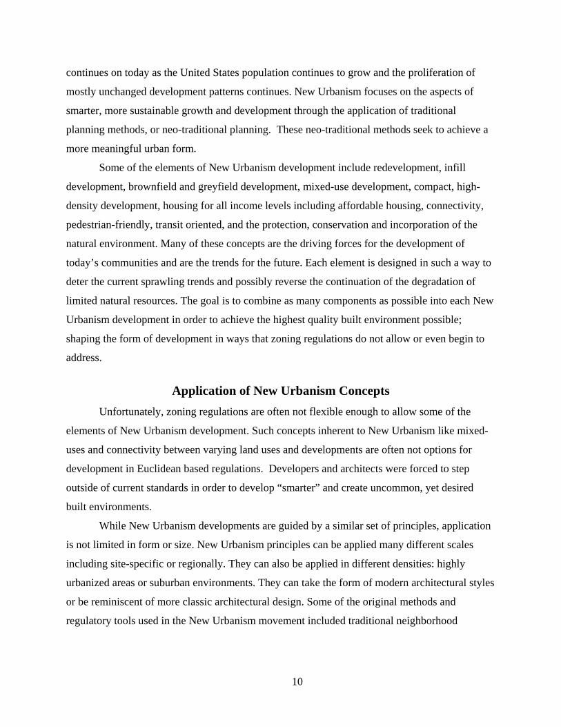
M., Dolnick, F., 2004). The following figure (Figure 3.1) is a sample diagram of a more
traditional compact neighborhood unit.
12
Figure 3.1 Traditional Neighborhood Unit Concept
Planned unit developments are another New Urbanism alternative to the use of zoning
regulations. While, the PUD concept actually predates the more modern New Urbanism
movement, it is still used as part of the New Urbanism repertoire. Many of the elements
incorporated in PUDs include components of sustainable urban development focusing on quality
urban design. Similar to TNDs, planned unit developments are used as optional regulatory
procedures that can be used to develop the built environment in ways that zoning regulations do
not allow. The American Planning Association defines planned unit developments as:
A development guided by a total design plan in which one or more of the zoning
or subdivision regulations, other than use regulations, may be waived or varied to
allow flexibility and creativity in site and building design and location.
(Davidson, M., Dolnick, F., 2004, 309)
13
PUDs allow for designers to take a more comprehensive approach to design. The
specified development area (PUD) is “developed as a single entity containing one or
more…residential developments and one or more public, quasi-public, commercial or industrial
uses in such ranges of ratios, and non-residential uses to residential uses as specified” (Davidson,
M., Dolnick, F., 2004, 309). The intent is not to view the development as a mass of single lots
but as an entire system of land, structures and uses. A comprehensive look at development also
allows for PUDs to have a more cohesive and compatible physical form. This can mean similar
architectural styles, compatibility of uses and connectivity.
PUD plans provide the opportunity to supplement or bypass common regulations and
standards and allow design flexibility. For example, by not creating separate lots for each land
use PUDs circumvent common site regulations, like building setbacks and height limitations, and
may allow for increased density. PUDs can include elements not common in basic Euclidean
regulations and thus focus on designing a more adequate built environment. Common planned
unit development plans include such elements as mixed-uses, connectivity between buildings and
varying uses, accommodations for multi-modal transportation, and the preservation of open
spaces.
As the awareness of the negative consequences of zoning regulations becomes more
apparent and wide-spread, the use of traditional neighborhood developments and planned unit
developments has increased since their inception. While they prove to be more adequate means
to craft conscientious developments, they still tend to be confined to traditional regulations and
standards and are mostly confined to relatively small scales.
Progression to Form-Based Codes The first true form-based codes development was applied in Seaside, Florida in 1981 by
the firm of Duany Platter-Zyberk and Company. The town of Seaside is a coastal town on
Florida’s panhandle and has been highly recognized and publicized through the years as a place
that exemplifies good, thoughtful design. Seaside is a relatively small community of only 80
acres, but is seen as “a place of great importance in American urbanism” explains Peter Katz
(1994, p. 3). Seaside was a clear departure from typical design principles and the process that led
to it. Peter Katz’s book entitled The New Urbanism: Toward an Architecture of Community,
describes the development in detail.

14
The town’s designers and architects Andres Duany and Elizabeth Plater-Zyberk
overarching goal for Seaside was to incorporate a strong sense of community. This meant
“asserting the primacy of public over private” by steering away from typical design patterns that
alienated contemporary towns and cities (Katz, 1994, p. 4). In following this approach, Duany
and Plater-Zyberk first defined the public spaces. To them, public spaces included not only parks
and civic spaces but also streets, walks and natural features of the site. Upon developing a system
of public spaces, the designers filled in around the public spaces with private buildings using a
newly developed “coding strategy” (Katz, 1994, p. 4). Figure 3.2 is a picture of Tupelo Circle in
Seaside, FL demonstrating the emphasis placed upon the architectural standards, public spaces,
vistas and the general consciousness of the 3-D environment.
Figure 3.2 Tupelo Circle in Seaside, Florida
Additionally, with public spaces being the defining element of development, Duany and
Plater-Zybek sought to incorporate connectivity and pedestrian friendly spaces; thus, Seaside
was densely developed that followed the principle of the “five-minute walk” or the traditional
neighborhood unit concept (Katz, 1994). This also helped to reduce the dependence on
automobiles and promote social interaction within the community (Katz, 1994).
Duany and Plater-Zybek first sought the input of individuals, clients, staff, fellow
designers, local officials and consultants as to what the design of the community should be.
15
“This was the firm’s first use of the charette methodology for participatory planning” (Katz,
1994, p. 4). After weeks of input the planners decided to leave the design of individual buildings
up to others, but guiding them through the use of prescriptive codes. The short, yet thorough
standards described what form a building can and should take. The guidelines were mostly
comprised of “simple diagrams and captions that physically describe a specific building type”
(Katz, 1994, p. 6). Duany and Plater-Zybek also realized that through the use of prescriptive
guidelines and clear illustrations, the codes were easier to understand and implement versus
traditional zoning regulations.
Some regulating elements that the Seaside’s form-based code contains includes build-to
lines, thus defining the public space of the street, uniform setbacks on north-south streets
designed to preserve views to the sea, sand walkways that cut through blocks to increase
walkability, and front porches of a minimum size and proximity to the street. As noted
previously, public spaces include more than just parks; pavilions, boardwalks and the beach itself
are considered to be public facilities. Also included are architectural and landscape regulations
established to maintain aesthetic appeal (Katz, 1994).
To this day, almost 30 years later, Seaside still has a comprehensive, coherent,
compatible form that is desirable for the “future of urbanism in America” (Katz, 1994, p. 6).
Katz states that:
Unlike other recent master-planning efforts, many of which resemble a
‘catalogue’ of the architectural styles popular during each decade of their build-
outs, Seaside’s resilient urban structure seems to transcend such issues. Evidence
of this is the way it graciously accommodates building of many disparage styles.
(Katz, 1994, p. 6)
Katz explains that Seaside was originally designed to be an inexpensive beachfront
vacation community; today it is more like an upscale resort. According to Katz, in 1994 the town
had seen a tenfold increase in residential lot prices in the decade since it was founded and the
town was 70 percent built-out as planned.
Modern form-based codes have not only been applied in Seaside, Florida but have also
seen successes elsewhere and for many years now. Peter Katz’s book illustrates the first
applications of form-based codes. It exemplifies the overall applicability of form-based codes by
16
showing that they can be successfully implemented not only in greenfield development, but also
in urban infill.
One particular example of one of the earlier urban form-based codes projects in the
United States was in Hayward, California in 1992, 11 years after Seaside’s Plan was developed.
The Hayward project focused on revitalizing downtown Hayward. Along with the input of the
public Daniel Solomon, an architect developed a master plan that sought to “restore the
economic vitality and pedestrian character of downtown” (Katz, 1994, p. 129). Elements of the
plan included a new civic center with public plaza, a transit center for bus and commuter rail
riders, housing and a retail corridor. The district was developed at higher densities than
conventional development pattern in order to encourage walking and connectivity within the
district. Again, the elements of New Urbanism were desired for development and form-based
codes became the means for incorporating the concepts into the urban form.
The success of Seaside’s community bodes well for the use of form-based codes. While
such design aspects as the desire to optimize waterfront access and views are specific to
Seaside’s geography and the incorporation of access to transit in Hayward are site specific, the
underlying regulating principles of connectivity, walkability, social interaction, and public open
spaces is a highly desirable form of urban development today. In addition, these are all concepts
that define New Urbanism and assist in creating quality places. These are the design elements of
the future and can be implemented through the use of modern form-based codes.
17
CHAPTER 4 - Application of Modern Form-Based Codes
Problems with Traditional New Urbanism Techniques The initial means of implementation of New Urbanism concepts including TNDs and
PUDs can be an effective means to supplement or bypass traditional zoning regulations. Do not
do enough to shape form community-wide, because they are often implemented They do not
make a big enough change to conventional zoning habits. Particularly with PUDs, much of the
conventional zoning, use-based, regulations still exist. Additionally, TNDs and PUDs are often
optional regulations within communities that developers can elect to implement, but many do
not. Now has come the time to think “bigger.”
The present day issues of global warming, sprawl, rising fuel costs and the general
awareness that our natural resources are limited demands action from today’s societies. Part of
the problem is, is that the way in which we develop only assists in increasing the nation’s
problems. While form-based codes are unfortunately not the solution to the world’s problems,
they have the ability to adapt to today’s changing needs and address some of the possible
solutions to the problems inflicted upon the urban, suburban and natural environment. There are
multiple means to combat the harmful effects of sprawl and many people argue that code-based
regulations will help in those efforts. New Urbanism concepts that are commonly included in
code regulations include Today’s form-based codes seek to be the new standard for which to
implement the New Urbanism concepts creating a more significant and conscious built
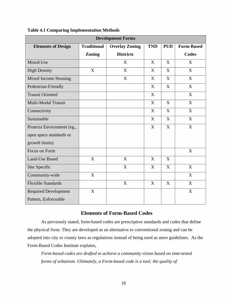
environment. Table 4.1 is a comparative chart of the previously addressed development methods
and the elements included and/or lacking within each regulation type. Traditional zoning
regulations are considered to be the very basic, original land use oriented standards. Overlay
zones included many different forms of adapted zoning regulations.
18
Table 4.1 Comparing Implementation Methods
Development Forms
Elements of Design Traditional
Zoning
Overlay Zoning
Districts
TND PUD Form-Based
Codes
Mixed-Use X X X X
High Density X X X X X
Mixed Income Housing X X X X
Pedestrian-Friendly X X X
Transit Oriented X X
Multi-Modal Transit X X X
Connectivity X X X
Sustainable X X X
Protects Environment (eg.,
open space standards or
growth limits)
X X X
Focus on Form X
Land-Use Based X X X X
Site Specific X X X X
Community-wide X X
Flexible Standards X X X X
Required Development
Pattern, Enforceable
X X
Elements of Form-Based Codes As previously stated, form-based codes are prescriptive standards and codes that define
the physical form. They are developed as an alternative to conventional zoning and can be
adopted into city or county laws as regulations instead of being used as mere guidelines. As the
Form-Based Codes Institute explains,
Form-based codes are drafted to achieve a community vision based on time-tested
forms of urbanism. Ultimately, a Form-based code is a tool; the quality of
19
development outcomes is dependent on the quality and objectives of the
community plan that a code implements.
(“Definition of a Form-Based Code,” 2009, para. 3)
Each design and form is unique to each community and each development, but there are
consistent components of each code and/or plan. Form-based codes include various elements, but
most include such common elements as a regulating plan, public space standards, building form
standards, administration and definitions. Codes sometimes include architectural, landscape,
signage and environmental resource standards (2009). The codes are expressed using both
diagrams and words. The following are definitions of what each element is as the Form-Based
Codes Institute defines them, and a sample code of each taken each standard is illustrated. The
examples are from the City of Blue Springs, Missouri Downtown Development Plan and
SmartCode version 9.2, which is a sample code document intended for the development and
implementation of municipal code regulations. See Appendix A for SmartCode v. 9.2 reference
tables.
A regulating plan is: “A plan or map of the regulated area designating the locations where
different building form standards apply, based on clear community intentions regarding the
physical character of the area being coded” (“Definition of a Form-Based Code”, 2009, para. 4).
The regulating plan determines the spatial basis of the ordinance. Whether the codes are intended
to be used for neighborhoods, districts, corridors, special purpose zones or community-wide,
most regulating plans use “transect zones” to establish the sub-classifications of properties and
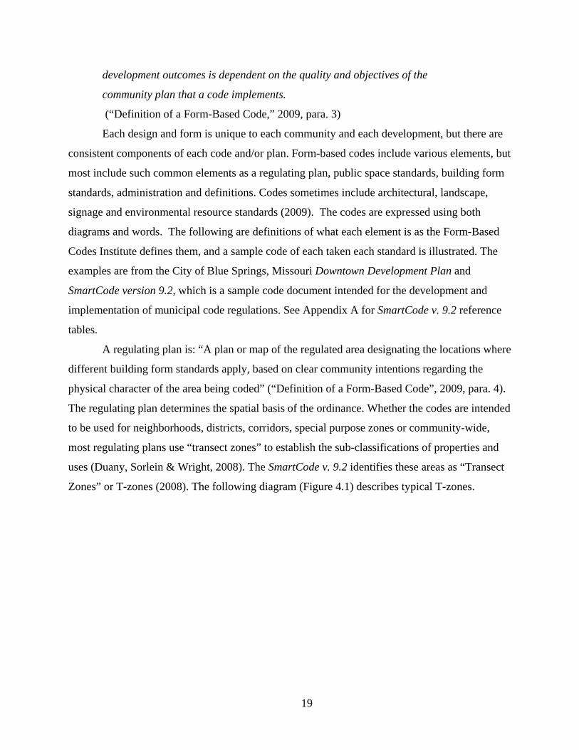
uses (Duany, Sorlein & Wright, 2008). The SmartCode v. 9.2 identifies these areas as “Transect
Zones” or T-zones (2008). The following diagram (Figure 4.1) describes typical T-zones.
20
Figure 4.1 SmartCode v. 9.2 Transect Zone Descriptions
21
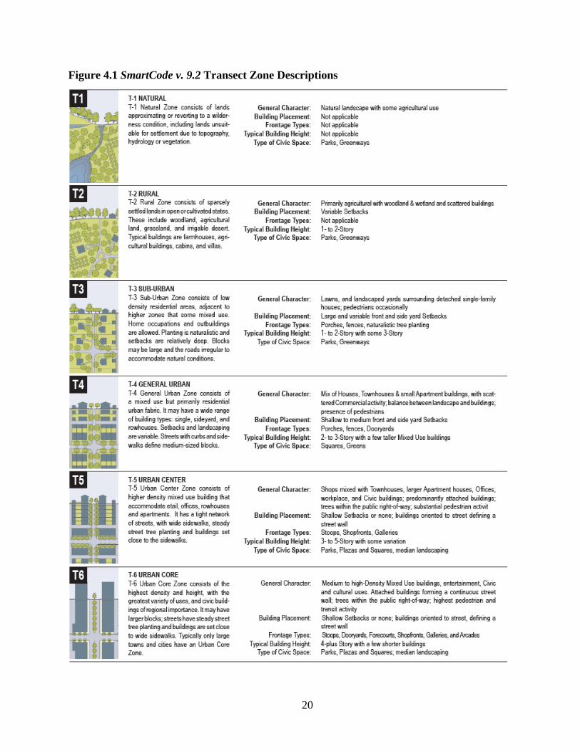
The transects progress from rural to urbanized. They are based upon the “level of
intensity of their physical and social character” (Duany, Sorlein & Wright, 2008, p. vi). The
urban development zones begin with “T3” and typically are the densest at zone “T6.” Some
characteristics of lesser urban zones include larger blocks, primarily residential, more
landscaping, detached buildings, yards and porches, deep setbacks, generally pitched roofs, roads
and lanes, narrow paths, larger curb radii, open swales, mixed tree clusters, local gathering
spaces, parks and generally is quieter. Alternatively, more dense urban zones include smaller
blocks, primarily mixed-uses, larger buildings, more hardscape, attached buildings, aligned
frontages, stoops and shop fronts, shallow setbacks, generally flat roofs, streets and alleys, wide
sidewalks, dedicated parking, smaller curb radii, raised curbs, aligned street trees, regional
institutions, plazas and squares and more noise is allowed/expected. (Duany, Sorlein & Wright,
2008)
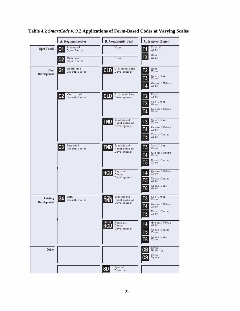
The SmartCode v. 9.2 specifically calls for the use of transect zone classifications for new
communities and specific lot and building standards, but in actuality the concept can be applied
at a regional scale or for development and redevelopment of established communities. The
“transects” are simply a way for describing a geographic area, and thus can really be called by
any name. The classifications help to simplify the code by organizing each area into zones
similar to familiar current zoning regulations, but they do not focus on classifications based upon
use. The classifications can be tailored to describe the character, density, and expected and
desired growth as they relate to each municipality. At a regional scale the authors of the
SmartCode suggest establishing the locations where development is allowed. At a community
scale FBCs can be used for new development or redevelopment in specified districts such as
cluster developments, traditional neighborhood developments, or regional centers. Table 4.2
illustrates the different scales at which form-based codes can be implemented.
22
Table 4.2 SmartCode v. 9.2 Applications of Form-Based Codes at Varying Scales

23
Once the transect zones are defined within the regulating plan, they are applied to the
intended geographical area using a plan map. Figure 4.2 shows the City of Blue Springs
Downtown Master Plan identifying the applicable zones. The zone names and general character
of the transect zones as identified in the Blue Springs zoning map are identical to those of the
SmartCode v. 9.2 transect zones.
Figure 4.2 City of Blue Springs, Missouri Downtown Zoning Map
Following the delineation of each zone/the regulating plan, each following standard then
varies according to the zone category.
24
Public space standards are: “Specifications for the elements within the public realm (e.g.,
sidewalks, travel lanes, on-street parking, street trees, street furniture, etc.)” (“Definition of a
Form-Based Code,” 2009, para. 4). Public space standards are often also called urban standards.
The modified urban standards sometimes combine the public space standards and building form
standards because the physical form of the built environment directly affects the public realm.
The public space standards focus on providing pedestrian accessibility, connectivity, streetscape
elements, and define form as it relates to a pedestrian scale. As with all aspects and standards of
FBCs the goal is create unique, relevant spaces and places. The following table (Table 4.3)
shows sample public frontage standards.

25
Table 4.3 SmartCode v. 9.2 Public Frontage Standards
Also included in proceeding SmartCode v. 9.2 tables are landscape and street lighting
standards. As the zones get closer to the “urban core” designation, greater emphasis is placed
upon creating a pedestrian friendly and attractive urban environment. This is achieved by
requiring larger sidewalks and pedestrian walkways, smaller-scale lighting elements, public
spaces, and streetscaping that does not interfere with pedestrian or vehicular traffic.
Building form standards are: “Regulations controlling the configuration, features, and
functions of buildings that define and shape the public realm” (“Definition of a Form-Based
Code,” 2009, para. 4). Examples of building form standards include building placement, height,

26
land use and parking placement. Each of these is used to shape the private realm and employ a
common pattern of development standards to ensure a desirable urban form and protect the
pedestrian environment. Greater densities and larger buildings are permitted closer to the urban
core and are highest at the “T6” – urban core zone designation. The table below (Table 4.4)
includes typical building form regulations as they are applied to transect zone “T3.”
27
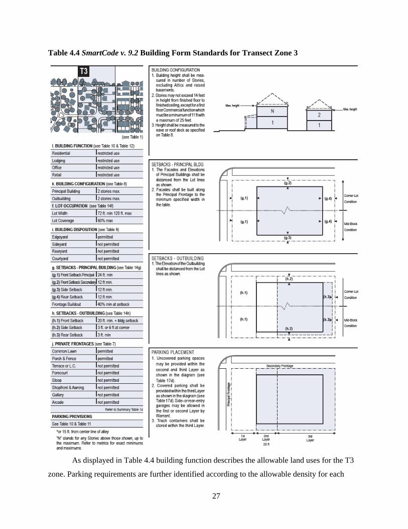
Table 4.4 SmartCode v. 9.2 Building Form Standards for Transect Zone 3
As displayed in Table 4.4 building function describes the allowable land uses for the T3
zone. Parking requirements are further identified according to the allowable density for each
28
permitted use. Building configuration limits the maximum number of stories and height
configurations with some flexibility depending on the use. The lot occupation defines the
minimum and maximum lot size within T3 zones and allows for 60% maximum building
coverage. Building disposition refers to the placement of structures on each individual lot and
establishes basic building types for each transect zone. Building setbacks are defined as they
relate to the principal structure on the lot and as they relate to the accessory structure, or
“outbuilding.” Private frontages refer to the area between the building façade and lot lines.
These also include private frontage, public frontage and right-of-way regulations for each type of
propped private frontage. Larger frontages are permitted in less dense zones in order to provide
a buffer from higher speed thoroughfares. Smaller frontages in more dense urbanized zones
allow for greater building coverage per lot and encourage pedestrian activity and interaction.
Administration contains: “A clearly defined application and project review process”
(“Definition of a Form-Based Code,” 2009, para. 4). The administrative section often defines the
legal background or authority for adoption, applicability, code intent, application and review
process including the process for deviations, and succession. The content is regulated by state
and local procedural laws. In most cases FBC ordinances are enforceable development
regulations when adopted in accord with the Comprehensive Plan (The legal basis for FBCs will
be addressed later).
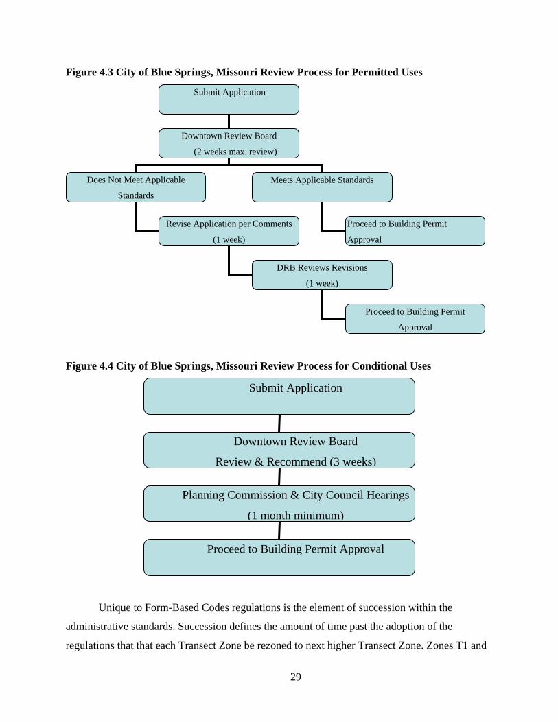
The development review process within FBC regulations is often expedited. With the
emphasis of FBC being placed upon design versus land use there are generally not as many
variances and additional review processes required for development review. Overall form-based
codes allow for greater flexibility of land use and development forms. The City of Blue Springs
has a stand-alone process for proposals within the downtown form-based codes district in order
to expedite the applications that conform to the Downtown Master Plan. The processes are
illustrated below in Figure 4.3 and 4.4 are adapted from the Blue Springs Downtown
Development Code. The first figure illustrates the process taken for permitted uses and the
second illustrates the process for uses permitted through the Conditional Use permitting process.
The permitted path is shortened because it does not require a public hearing. Both paths are
shortened because they do not require pre-application meetings or development reviews that are
required for traditional zoning applications, i.e. platting, conditional use permits, rezoning, etc.
29
Figure 4.3 City of Blue Springs, Missouri Review Process for Permitted Uses
Figure 4.4 City of Blue Springs, Missouri Review Process for Conditional Uses
Unique to Form-Based Codes regulations is the element of succession within the
administrative standards. Succession defines the amount of time past the adoption of the
regulations that that each Transect Zone be rezoned to next higher Transect Zone. Zones T1 and
Submit Application
Downtown Review Board
(2 weeks max. review)
Does Not Meet Applicable
Standards
Meets Applicable Standards
Proceed to Building Permit
Approval
Revise Application per Comments
(1 week)
DRB Reviews Revisions
(1 week)
Proceed to Building Permit
Approval
Submit Application
Downtown Review Board
Review & Recommend (3 weeks)
Planning Commission & City Council Hearings
(1 month minimum)
Proceed to Building Permit Approval
30
T2 are exempt from rezoning in order to prevent unnecessary sprawl and protect the naturalized
environment. The succession can be denied through the public hearing process by the Legislative
Body. (Duany, Sorlein & Wright, 2008) The need for a succession clause varies per each
community depending on rate of growth, scale and intent.
Additional articles included in the SmartCode v. 9.2 are use incentives, affordable
housing incentives and hazard mitigation standards. These standards are usually not unique to
FBC regulations, but help to encourage the use of form-based codes when they are included
within the development standards.
Architectural standards are: “Regulations controlling external architectural materials and
quality” (“Definition of a Form-Based Code,” 2009, para. 5). The architectural standards should
derive from community input and mirror a desired architectural style. The Blue Springs
Downtown Development Code stresses that “the standards relate to the vernacular building
traditions of the region…[and] produce visual compatibility among disparate building types”
(2007, p. 6). Permitted materials and configurations for walls, roofs, openings and facades are
defined within the architectural standards. The building materials listed in the Blue Springs code
is rather flexible, but calls for the use of high quality masonry building materials like stone,
brick, cast stone and Stucco. The provisions generally seek to “ensure a longer-lasting,
sustainable appeal of the downtown” (Downtown Development Code, 2007, p. 36). As
municipalities seek to have more control to ensure compatibility and application of a very
specific architectural form the regulations can be more definitive and limited.
Landscaping standards are: “Regulations controlling landscape design and plant materials
on private property as they impact public spaces (e.g. regulations about parking lot screening and
shading, maintaining sight lines, ensuring unobstructed pedestrian movements, etc.) (“Definition
of a Form-Based Code,” 2009, para. 5). Most landscape standards include location and planting
patterns for both public and private uses. Landscaping standards are described as general to all
zones and specific to each zone. More landscaping is required further away from the urban core
including lawns requirements and trees. The plantings are coordinated in order to achieve a
coherent linkage from the urban to rural transects. Within the urban transects landscaping is
encouraged “[achieve] a forestation of the urban fabric” (“Downtown Development Code,”
2007, ). Landscape elements assist in creating a visually appealing urban environment and

31
encourage pedestrian access. Landscaping standards also help to preserve natural elements and
assists in creating the highly desirable “green” development.
Thoroughfare standards are: “specifications and dimensions that assembles vehicular and
pedestrian ways…specialized in both capacity and character” (Downtown Development Code,
2007, p. 6). Vehicular lane dimensions are assigned per zone and specify the design standards
including speed, lane width and turning radius. Where on-street parking is allowed, additional
vehicular lanes and parking requirements are established. On-street parking is traditionally not
allowed in the rural zone, T1 and T2. Allotments for street parking increase the more dense the
transect zone. Also, each thoroughfare type is assigned to transect zones and defined within the
“thoroughfare assemblies” standards. Table 4.5 illustrates the SmartCode v. 9.2 sample
thoroughfare assembly standards.
32
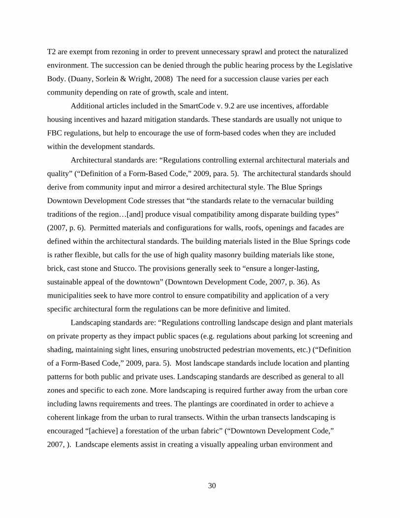
Table 4.5 SmartCode v. 9.2 Thoroughfare Assembly for a Street in Transect Zones 4, 5 & 6
Signage standards are: “Regulations controlling allowable signage sizes, materials,
illumination, and placement” (“Definition of a Form-Based Code,” 2009, para. 5). There are
general regulations for all zones and specific regulations per each zone. Most communities
already have signage regulations in place, but more specific regulations can be established in
order to maintain aesthetic appeal and ensure compatibility with the designated architectural
styles. Within the sub-urban transects little signage is allowed, because of the typically
residential nature of development. More signage and larger signage is typically permitted for
commercial, urban sectors.
33
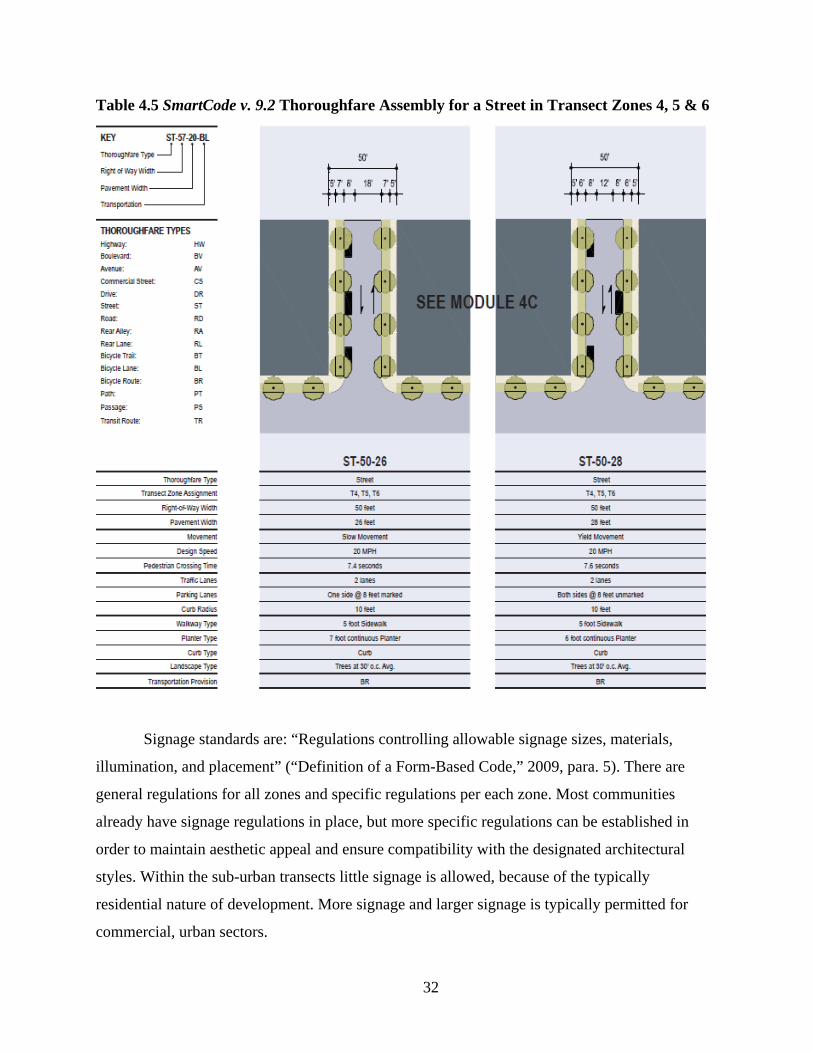
Environmental Resource standards are: “Regulations controlling issues such as storm
water drainage and infiltration, development on slopes, tree protection, solar access, etc.”
(“Definition of a Form-Based Code, 2009, para. 5). Many of the environmental resource
standards are progressive “green” standards that aim to protect the environment and ensure
quality development. Additionally, such standards can also include growth standards, infill
regulations, or preservation of open space. These regulations are often supplemental to growth
boundaries, flood plain regulations and already protected lands, eg., state parklands. The
following figure (Figure 4.5) shows a sample environmental resource standard that focuses on
defining where growth is most appropriate and what natural elements should be protected.
Figure 4.5 SmartCode v. 9.2 Environmental Resource Standards
34
Also included within form-based code regulations are definitions, which “ensure the
precise use of technical terms” (“Definition of a Form-Based Code,” 2009, para. 4). These terms
are clarifications to technical language within the code, and are an important element when
adopting form-based code regulations. Their intent is to increase understanding of the codes
making them easier to use and enforce.
The elements listed previously are both common elements within form-based codes and
others are more tailored and used discretionally. Each element should be analyzed for
applicability as they relate to the needs of each individual community and the goals of the FBC
regulations. They can be used as a basic template, but should more clearly defined by the entity
that develops the codes. Additional elements might be required for special districts or
extenuating circumstances. Overall FBC regulations will vary per community based on necessity
and the scale at which the codes are applied.
Legality The legal basis for implementation and enforceability of form-based code ordinances lies
within state and local governments’ ability to exercise police power, which protects and
promotes the health, safety and general welfare of its citizens. Comprehensive plans, zoning
regulations, subdivision standards, and other development ordinances including form-based
codes are adopted to promote and protect those things, and thus are a legitimate exercise of
police power when applied reasonably and without bias. In some states it is required that a city
adopt a comprehensive plan before they can adopt form-based coding, and the codes must then
follow the general plan guidelines. In 2004, California adopted legislation that specifically
enabled the practice of form-based development regulations (Katz, 2004). The bill reads:
The text and diagrams in the land use element [general plan]…may also express
community intentions regarding urban form and design. These expressions may
differentiate neighborhoods, districts, and corridors, provide for a mixture of land
uses and housing types within each, and provide specific measures for regulating
relationships between buildings and outdoor public areas, including streets.
(Katz, 2004)

35
Other states just require that a plan be prepared, while others enable, but do not require
that plans be prepared or that zoning regulations be used at all. (Katz, 2004) It is important to be
aware of the enabling legislation requirements when developing form-based codes.
Additionally, it is important that the codes are not overly prescriptive so as not to
encroach into private property rights. They should be more similar to typical unified
development ordinances than optional design guidelines, but again will vary depending upon
scale and intent.
Adopting Form-Based Codes The process towards adoption of form-based code ordinances can be quite lengthy and is
very detailed. The form-based codes book developed by Parolek, Parolek, and Crawford breaks
to process into a “pre-phase” and then three supplemental phases. The pre-phase is entitled
“scoping.” Phase one includes “documenting” or evaluation of existing inventory, phase two
involves “visioning,” and the final phase calls for “assembly” (Parolek, Parolek & Crawford,
2008, p. 96).
Step One
The “pre-phase” or first step is making the initial decision about the size and extent of the
code regulations. This includes deciding who will be involved, what areas of the municipality
will be included, which elements of the code might be necessary and how the code might fit in
with the existing regulatory framework (Parolek, Parolek & Crawford, 2008).
Most municipalities choose to involve their planning department, departmental directors
and hire a consulting firm. These selected members should be involved throughout the entire
process. Consultants are often hired for their additional knowledge and skills. Developing form-
based codes involves a great deal of design work, which some planners are not accustomed to, so
assistance from consultants is necessary. When choosing a consulting firm it is important to
match the community’s needs with a consulting team that has the right qualifications and prior
experience. Appendix A is a sample Request for Qualifications (RFQ) put together by the Form-
Based Codes Institute.
The next step in the pre-phase process is to determine the application area and the degree
of change that is desired. The degree of change relates to the extent of physical change that is
expected and desired for the designated areas. The different degrees can aim to simply to
36
preserve, to preserve and enhance, encourage physical change over time, or to transform the
physical environment within the shortest amount of time possible (Parolek, Parolek & Crawford,
2008).
Following the determination of the application area it is time to determine the
implementation method. This includes analysis of state laws to determine the public process and
extent to which form-based codes can be adopted by the local legislative body. Within that
framework communities can choose to entirely replace conventional zoning regulations with
FBC regulations, as optional and freestanding regulations, as an “embedded form-based zone,”
or as a floating zone. A comprehensive replacement approach allows for consistency throughout
the community, but can be a challenging undertaking. Optional, freestanding codes are stand
alone codes that do not replace traditional zoning regulations. Developers are given the choice to
use the codes is specified areas or for project sites that meet certain minimum requirements.
Embedded form-based zones are mandatory and integrated into existing zoning regulations. This
allows for gradual change with certain areas being “rezoned” to form-based zones. Finally,
floating zones are similar to traditional New Urbanism implementation methods of Traditional
Neighborhood Developments and Planned Unit Developments. These zones are applied only
when a developer wishes to use the FBC. (Parolek, Parolek & Crawford, 2008)
The final step within the pre-phase process is to select an approach to coding. This means
defining an organizing principle which is used as the basis for the regulating plan. There are
various templates being used, but the most common is the transect method. If choosing to select
a template, e.g. SmartCode v. 9.2, it is important to customize it to define the community needs.
Step Two
Step two, or “phase one,” is the documenting phase. This phase involves an analysis of
the existing conditions and inventory. The evaluation will help the code developers understand
the existing character and patterns of development within the municipality. In the article “Form-
Based Codes: Implementing Smart Growth,” Dave Davis notes that inventory typically includes
an analysis of street types, walkways, landscape, block shape and size, alleys, parcels, building
footprints, streetfronts, pedestrian and vehicular access, front and side yards, squares and parks,
undeveloped parcels, parking types and location and natural features like, creeks, wooded areas,
vistas and significant topography. Through this evaluation planners and other design
37
professionals involved in the development process can diagnose problems and begin to identify
possible solutions. (Davis, 2008)
Step Three
Step three, or “phase two,” is the “visioning phase” (Parolek, Parolek & Crawford, 2008,
p. 96). This step entails developing the desired form for the built environment that is defined by
the community. Public participation is at the heart of the visioning process because, after all, the
intent of the codes is to create a more desired urban form. Also, because FBCs are public
documents that directly affect the community, public input is critical and required. While public
engagement is imperative in this phase, it is important to remember that the designers, staff and
other municipal officials should help guide the public through this process. This means that the
citizens should have clearly defined alternatives, examples and a sense of direction that was
previously established in steps one and two.
The public input process can occur in many forms. One more common method is a
design charette. The charette allows for residents, property owners, city officials and others to
give their input on design, policy and management issues. A well-run charette often includes
visual representations of various alternatives to explore, and allows the public to discuss and
even alter the possible design scenarios. Charettes are often held on multiple days and
incorporate focus group meetings, workshops, presentations and public engagement (Davis,
2008). Through the use of charettes involved parties can analyze different scenarios and
hopefully come up with a feasible and meaningful plan for future development. The number of
public input sessions will vary per community based upon how volatile the changes are and how
many people choose to participate. No matter how many public input sessions are held it is
important to remember that public input is the key to successful, significant codes. Public
participation creates excitement and momentum for change and can help make the adoption
process much easier.
Step Four
Step four is the final phase in developing form-based code regulations. This step calls for
the assembly of the code content and includes finalizing all illustrations, tables, diagrams and the
standards that match the decided form. This includes the combination of scale, identifying
organization (i.e. transects), and all additional standards that shape the urban form including, but
38
not limited to, the urban, architectural, landscape, and public space standards. The format of the
codes should be well thought out in order to make them easy to understand and should only
include relevant, concise information. All relevant information for implementing the FBC should
be contained in one document to discourage cross-referencing and obscure terms. Illustrations
should be clear and exemplify the desired development patterns. The final document itself is
usually completed by a consulting firm, but is not required.
Advantages There are many noted advantages to form-based codes and the larger principles of New
Urbanism. Some are mutual; while others are exclusive to FBCs. Shared benefits include
limiting unnecessary expansion/sprawl by allowing for redevelopment and infill development,
creating walkable, inter-connected communities, encouraging environmental protection, and
overall creating more sustainable communities.
The Form-Based Codes Institute cites eight major advantages of form-based codes over
conventional zoning regulations. These include:
1. “Because they are prescriptive (they state what you want), rather than proscriptive (what you do not want), form-based codes can achieve a more predictable physical result” (Katz, para. 1). They better control the elements that shape the form of the built environment.
2. “FBCs encourage public participation because they allow citizens to see what will happen” (Katz, para. 2). Katz notes that by allowing citizens to see what will happen, they are often more open to new development because they understand the regulations.
3. “Because they can regulate development at the scale of an individual building or lot, FBCs encourage independent development by multiple property owners. This obviates the need for large land assemblies and the megaprojects that are frequently proposed for such parcels” (Katz, para. 3). This allows for greater flexibility for mixed-uses at the parcel level, and encourages compatibility with surrounding developments.
4. “The built results of FBCs often reflect a diversity of architecture, materials, uses, and ownership that can only come from the actions of many independent players operating within a communally agreed-upon vision and legal framework” (Katz, para. 4). Again, this results from the discretion given to developers to develop individual buildings and lots within a clearly defined, yet flexible framework.
39
5. “FBCs work well in established communities because they effectively define and codify a neighborhood's existing "DNA." Vernacular building types can be easily replicated, promoting infill that is compatible with surrounding structures” (Katz, para. 5). FBCs are applicable at varying levels and can be molded to best fit each communities needs.
6. “Non-professionals find FBCs easier to use than conventional zoning documents because they are much shorter, more concise, and organized for visual access and readability” (Katz, para. 6). FBCs are developed with the average citizen in mind, thus they are often easier to understand. Ease increases efficiency for citizens, developers, public officials, designers and planners alike.
7. “They require less oversight by discretionary review bodies, fostering a less politicized planning process that could deliver huge savings in time and money and reduce the risk of takings challenges” (Katz, para. 7).
8. FBCs [prevent] the need for design guidelines, which are difficult to apply consistently, offer too much room for subjective interpretation, and can be difficult to enforce…The stated purpose of FBCs is the shaping of a high quality public realm, a presumed public good that promotes healthy civic interaction. For that reason compliance with the codes can be enforced, not on the basis of aesthetics but because a failure to comply would diminish the good that is sought. (Katz, para. 8)
Additional advantages as noted in the SmartCode v. 9.2 include:
1. “Enables smart growth community patterns that include Cluster Land Development,
Traditional Neighborhood Development, Regional Center Development, and Transit-
Oriented Development” (Duany, Sorlein, & Wright, 2008, p. viii).
2. FBCs “integrate the scale of planning…from regional through…architectural elements”
(Duany, Sorlein, & Wright, 2008, p. viii). The codes are highly adaptable ensuring
sustainability through longevity.
3. “Integrates the design process across professional discipline” (Duany, Sorlein, & Wright,
2008, p. viii). Input from multiple disciplines helps create a more significant regulation
document.
4. “Integrates the methods of environmental protection, open space conservation and water
quality control” (Duany, Sorlein, & Wright, 2008, p. viii). FBCs encourage and allow for
sustainable development concepts.
40
5. “Encourages the efficiency of administrative approvals when appropriate, rather than
decision by public hearings” (Duany, Sorlein, & Wright, 2008, p. viii). This saves time
and thus can save developers money creating an incentive for their use.
6. “Encourages specific outcomes through incentives, rather than through prohibition”
(Duany, Sorlein, & Wright, 2008, p. viii). For example, some FBC regulations allow for
increased density or flexibility on other layout requirements when additional elements are
included that are not required like more open space or affordable housing units.
7. Form-based codes "generally increase the range of options over those allowed by
conventional zoning codes” (Duany, Sorlein, & Wright, 2008, p. viii). The range of
options minimizes the need for variances, because there is a flexible set of standards.
Again, this makes the FBCs more user-friendly, saving time and money.
Evaluating Form-Based Codes When developing form-based code ordinances it is important that municipalities evaluate
their codes to determine their effectiveness. The Form-Based Codes Institute has organized a set
of general questions that reflect “best practices” of form-based coding. There are three main
questions that can be used when evaluating coding regulations:
1. “Is the code enforceable?”
2. “Is the code easy to use?”
3. “Will the code produce functional and vital urbanism?”
(“Checklist for Identifying,” 2008)
The answer to each question should be affirmative. Municipalities should also evaluate if
their code addresses the specified intentions, if the procedures for code administration are clearly
defined, are the codes coordinated with other applicable policies and regulations that control
development on the same property, and they should make sure that the code is designed,
intended and programmed to be regularly updated.
When evaluating how easy the code is to use municipalities should confirm that the
overall format and structure is clear so that users can easily find what is pertinent to their request,
the desired physical form is executable, the intentions are clearly describe and reasonable, the
technical terms are clearly defined and understandable for non-professionals, if the code is

41
formatted in such a way to “lend itself to convenient public distribution and use” (“Checklist for
Identifying,” 2008, para. 3).
To determine if the code will produce functional and vital urbanism, municipalities
should evaluate if the code will produce a pedestrian-friendly public realm and neighborhoods
that encourage social interaction, if it produces identifiable neighborhoods that provide for daily
needs, if the code is based upon a detailed regulating plan and other clear communities visions
that “directs development and aids implementation,” and finally if the “parking requirements are
compatible with pedestrian-scaled urbanism” (“Checklist for Identifying,” 2008, para. 4).
Overall it is important to make sure that the codes that have been devised actually assist
in creating the desired physical form and assists in achieving the goals that were defined at the
outset of development. The intentions should be clearly defined and recognizable throughout the
regulations. Finally, as planners and designers it is easy to understand technical terms and
envision grandiose schemes, but not even speaks the same language. The codes should be
developed with the non-professional in mind to ensure that the vision can be implemented.
Barriers and Drawbacks Like most development regulations there are barriers to overcome and some
disadvantages. Generally, the greater the change is, the greater the opposition is. Good strategic
planning and active public participation can help to overcome implementation barriers.
Common barriers to changes of development regulations include citizen and developer
opposition. Mostly people want to make sure that their property values will not be harmed by
any changes to the codes, and rightfully so. This is why public engagement is important to the
development of form-based codes. Involving the public and other investors within the
community will help to build momentum for FBCs, build the community’s trust in the code
developers, create a shared vision and increase understanding, which will hopefully muffle
credible opposition. People should be familiarized with the intentions, future goals, what the
changes will be and most importantly how the codes will affect them. This can be a long process
that will take patience, time and resources, but it will be worth it when the regulations are
adopted.
In the case of Miami, Florida’s “Miami 21” code developed by form-based code founders
Duany Plater-Zyberk & Company finalized in 2009, opposition almost proved to be too much to
42
overcome. The code was developed to replace the highly criticized existing zoning regulations
that was said to be outdated (Raterman, 2007). The intent was to overhaul the current zoning
code, but they realized that the city was too large to do make the change all at once, so they
sought to make the changes progressively by dividing the city into quadrants. Even through what
Charles Rabin writes in the Miami Herald that there were “literally hundreds of public
meetings,” the plans still saw adamant opposition (Rabin, October 2009, para. 2). There were
many concerning points brought up against the code, the most notable was that people were
concerned about the loss of property rights via development limitations and prescriptions placed
upon private property by the Miami 21 code (Rabin, August 2009). On August 6, 2009 the code
ordinance was denied for approval by the City Commission, more than four years after the first
phases of the code development began (Rabin, August 2009). Finally, after the second public
hearing held before the City Commission the document was adopted on October 12, 2009
(Rabin, October 2009).
Another hurdle to overcome when implementing form-based codes is the lack
knowledge. While FBCs have formally been used for almost 30 years now, they are still
somewhat uncommon. Zoning regulations have been the norm for development patterns for the
past 80 years. Many developers, designers and planners realize that alternative forms of
development are necessary, but simply do not know enough about form-based codes to use.
Aside from a possible lack of knowledge about form-based codes, Kaizer Rangwala most
notably argues that many planners just do not have the skills needed to develop form-based
design standards (p. 84). While form-based codes are aimed at making them easier to understand
than zoning regulations, especially for non-professionals, their development involves a
significant amount of technical design knowledge. In Rangwala’s article, “Retooling Planners,”
he states that for many planners, form-based codes enlist an entirely different skill set oriented
towards design, which is often not common practice for many planners (Rangwala, p. 84).
Implementing form-based codes requires a different set of ‘tools;’
The planning profession has its roots in physical planning, with an emphasis on
designing desirable and livable places. However, over the last century planners
have neglected the physical aspects of their profession… it exposes how little skill
and knowledge planners today have with crucial tools of graphic representation.
(Rangwala, p. 84-85)
43
Rangwala suggests placing more of an emphasis on urban design skills in architecture
and planning higher education institutions, which sounds to be a capable first step to increase the
popularity of form-based codes.
After possibly overcoming impediments to implementation, planners and designers must
also know that some drawbacks to form-based codes do exist. Knowledge of FBC can help
designers to foresee issues and work towards finding solutions.
As exemplified above, there is no guarantee of approval. The more opposition, whether
justified or unwarranted, can result in a denial of the codes. Also, as with any ordinance that goes
through the public hearing process and approval by municipality commissions, politics often
play a part. Volatile political environments can result in denial of adequately efficient,
sustainable and visionary codes. Be aware of the social environment in which you plan.
Overall form-based codes have to walk a fine line between what the designers want and
what the community will accept. Incremental changes can be implemented in order to “test” the
political and social environment. Codes ahead of their time that often include sweeping changes
and entirely new design elements might be what is needed, but not what is wanted. Many people
are also weary of change even if it is good. The community is the voice behind form-based
codes, not the designers and planners. Be aware of your community’s desires. There is a fine line
between prescriptive regulations and the violation of private property rights. FBCs should allow
for freedom of development within a defined code that truly seeks to protect the public.
44
CHAPTER 5 - Conclusions
The future of form-based codes looks promising. Zoning regulations are progressively
being realized as outdated, inflexible and inadaptable to societies needs for the physical
environment. With the “green” movement and New Urbanism becoming more and more popular,
the demand for new “smarter” development patterns will also continue to increase. Form-based
codes can be the regulations used to implement the new desired forms. The new, New Urbanism
tool. FBCs are being used more widespread now, so professionals and non-professionals can
become accustomed to what they do and how they achieve a defined goal. As they are adopted in
more communities there will hopefully be less resistance to them.
While there are several barriers and impediments to overcome, there are ways around
them. First, remember that public participation is key. With the support of the public and the
politicians adopting FBCs should be relatively smooth. Build trust with the community by letting
them know that their vision is important too. If designers of the code see that comprise and
consensus is needed, then they should seek to achieve them. Incremental changes might be
necessary. Part of this incremental change might also include labeling or codifying new form-
based codes similar to traditional zones. Many people have grown accustomed to zoning
regulations and they understand them, so why not format codes in a similar manner to make the
changes not seem so dissimilar.
For codes that have been adopted as “floating zones” or optional regulations, incentives
should be offered to developers to encourage their use; economic incentives greatly influence
development. There is also an overall benefit to the community when the codes are implemented
successfully, so the developer should also reap some of the benefits.
Another incentive or advantage of FBCs is that often the review process is
simplified. This means that time is saved, which most of the time means money is saved. After
all, as the saying goes, “time is money.” This component of the codes should also be stressed as
an incentive for using them. Some may contest though that while the administrative review
process might be shortened the initial design process is not. While it is probably true that there is
intended to be more consideration for design in the beginning of development, it is important to
45
note that with clearer more definitive codes, make the process is less ambiguous creating less
confusion allowing for fewer reviews or denials. This again assists in saving time and money.
As planners, particularly planners that work in the public realm, we often worry about
having the power to make changes within our communities. Education and flexibility will allow
for planners to keep their power within the world of design. As Kaizer Rangwala suggests in
“Retooling Planners,” much of the form-based codes are design based and are thus oriented away
from traditional planning practices giving the power to architects and other design professionals.
Rangwala suggests implementing more design-oriented courses into higher education
planning institutions. While this is definitely a way for planners to better understand a designer’s
language, it does not assist those who are already out of the traditional education realm. Access
to knowledge is important to professional planners in order to be cognizant of new development
trends, foresee community harms and plan alternatives. As the use of form-based codes persists,
it is important for planners to seek additional training and become educated about technical
design elements in order to remain relevant.
In the case where design knowledge is limited, planners should at least find ways
to make their codes more flexible. With new forms of development rapidly gaining popularity, it
is important for planners to be able to incorporate these forms within their communities. If a
municipality has not already done so, they should consider implementing some of the elements
of New Urbanism and form-based codes into their existing regulations. This means allowing
“floating” zones, overlay districts, mixed-use districts, TNDs and PUDs. This also includes
incorporating more open spaces into new developments, allowing for pedestrian-friendly
sidewalks and paths, or allowing compact development. Each of these elements can be
incorporated into use-based ordinances. Additionally, this allows for slower change that might
not be as vehemently opposed as sweeping changes.
Finally, once a vision has been defined and outlined it is important to make sure that the
codes can actually be used and implement the intended changes. An important step to developing
form-based codes should be a “test” phase. Non-professionals or inexperienced designers should
review the documents to ensure that the codes can be understood and implemented properly.
Also, a part of this “test” phase could be using the codes for a particular new growth
development area or special district. This way there are no large-scale changes. If changes occur

46
incrementally, planners can make amendments as necessary in order to ensure the use of the
codes and the proper application of the codes.

47
Bibliography
(2008, June 27). Checklist for identifying and evaluating form-based codes. Retrieved from http://www.formbasedcodes.org/checklist.html.
(2009, January 29). Definition of a form-based code. Retrieved from
http://www.formbasedcodes.org/definition.html. City of Blue Springs, Missouri. (2007). Downtown development code (Unified Development
Code Section 404.240). Manchester, MO: Sullivan Publications, Inc. Davidson, M., Dolnick, F. (eds.) (2004) A Planners dictionary. Planning Advisory Service,
521/522. Chicago, IL: American Planning Association. Davis, D. (ed.) Local Government Commission. (2008). Form-based codes: implementing smart
growth Sacramento, CA: Retrieved from http://www.lgc.org/freepub/docs/community_design/fact_sheets/form_based_codes.pdf.
Duany, A., Sorlein, S., & Wright, W. (2008). Smartcode version 9.2. New Urban News
Publications. Form-Based Codes Institute, (n.d.). Sample request for qualifications Retrieved from
http://www.formbasedcodes.org/resource.html. Katz, P. (1994). The New urbanism: toward architecture of community. United States: McGraw-
Hill, Inc. Katz, P. (2004, November). Form first. Planning Magazine. Katz, P. (n.d.). Eight advantages to form-based codes. Retrieved from
http://www.formbasedcodes.org/advantages.html. Parolek, D., Parolek, K., & Crawford, P. (2008). Form-based codes: a guide for planners, urban
designers, municipalities, and developers. Hoboken, NJ: John Wiley & Sons, Inc.. Rabin, C. (2009, August 7). Surprising vote kills Miami 21 zoning overhaul. Miami-Dade
Herald. Retrieved from http://www.miamiherald.com/news/miami-dade/story/1175161-p2.html.
Rabin, C. (2009, October 22). Pedestrian-friendly Miami 21 zoning code approved. Miami-Dade
Herald. Retrieved from http://www.miamiherald.com/460/story/1296056.html. Rangwala, K.. Retooling planners. Places, 17(1), 84-85.
48
Raterman, D. (2007, December). In the tropical zone. Planning Magazine, 34-37. Rouse, David, Nancy Zobl (2004). Form-based development codes. Zoning Practice. , 21(5), 2-
7. Russell, J., & Greenberg, E. (2004). Codifying new urbanism. Planning Advisory Service. 526.
Chicago, IL: American Planning Association. The Seaside Institute (2009). Town Architect’s Forum. Image retrieved from
http://www.theseasideinstitute.org/net/content/page.aspx?s=74884.0.79.7801. Sustainable neighborhood planning for the region: neighborhood scale. Treasure Coast Regional
Planning Council. (2004). Retrieved January 3, 2009, from Treasure Coast Regional Planning Council Web site: http://www.tcrpc.org/orientation/02_neighborhood_scale/slide03.jpg.
Sperber, B. (2005). Function follows form. Professional Builder, Retrieved from
http://www.housingzone.com/article/CA6253706.html. Talen, E. (2009). Design by the rules: the historical underpinnings of form-based codes. Journal
of the American Planning Association, 75(2), 144-160. Tombari, E. (2009, Spring). The Future of zoning. Land Development, 22(2), 23-26.
49
Appendix A - Sample Request for Qualifications (RFQ)
SUGGESTED SCOPE OF SERVICES:
PRIMARY WORK PRODUCT: This contract will result in a proposed form-based code,
meant to supersede (either entirely or in part) the present zoning ordinance and other local land
development regulations that apply to [insert name of area]. This code is to be consistent with
the definitions and evaluation criteria established by the Form-Based Codes Institute (FBCI); see
www.formbasedcodes.org for more details.
1. INITIAL REVIEW AND ANALYSIS
a. Interviews. The Consultant will interview appropriate stakeholders involved with the project. These interviews will include groups and individuals including elected officials, nonprofit organization leaders, property owners, neighborhood representatives, local design professionals, developers, business organizations, and municipal staff.
b. Site Analysis. The Consultant will become familiar with the physical details of [area to be coded] and the historic patterns of urbanism and architecture in the surrounding region.
c. Media coverage. The Consultant will participate in a press conference with local officials and draft a press release to inform the local citizenry about the planning efforts to be undertaken.
d. Website. The Consultant will provide information for [the municipality’s] website. As officials deem appropriate, the Consultant will provide materials including text, photographs, maps, renderings, and other images for the web site. This material will describe the Consultant’s credentials and help explain the project’s process.
2. PUBLIC DESIGN PROCESS
a. Generate necessary background maps. [Municipality] will provide all necessary base map information as needed by the Consultant. These documents will be used

50
to produce the maps that will be used during the preparation of the form-based code.
COMMENTARY: The next sections describe a public process
for generating the detailed physical plan that underlies a form-based
code. In some circumstances this step will already have been completed
and the code work can begin without the full step of a new planning
charrette; but in most cases, this critical planning step must be
undertaken first.
b. Public Workshop and/or Design Charrette. The Consultant will organize and lead design workshops or a full planning charrette to engage the community, gather ideas and goals, and formulate implementation strategies. The Consultant will tailor the workshop or charrette to obtain maximum community input so as to produce the best possible master plan on which to base the new code. The charrette format will also take into consideration the findings of the initial site analysis, input from staff, and information obtained at previous meetings, workshops, and interviews. While the end result will be new land development regulations, the public process will include discussions of alternatives for street design, street connectivity, and town planning strategies that create vital town centers, corridors, and livable neighborhoods. At the conclusion of the workshop(s), the Consultant will present the work generated to-date. Plans, renderings, and initial coding ideas that reflect ideas articulated in the workshops will be publicly presented and further feedback solicited from the community. It is essential that local government officials attend this presentation along with citizens, stakeholders and technicians.
3. DRAFTING THE FORM-BASED CODE
a. Design Parameters for the Form-Based Code. The new code will regulate development to ensure high-quality public spaces defined by a variety of building types and uses including housing, retail, and office space. The new code will incorporate a regulating plan, building form standards, street standards (plan and section), use regulations as needed, descriptive building or lot types (optional), and other elements needed to implement the principles of functional and vital urbanism and practical management of growth. Sections of this document would typically include the following:
• Overview, including definitions, principles, and intent; and explanation of the regulations and process in clear user-friendly language.
51
• Regulating Plan (a schematic representation of the master plan) illustrating the location of streets, blocks, public spaces (such as greens, squares, and parks), and other special features. Regulating plans may also include aspects of Building Form Standards such as “build-to-lines” or “required building lines” and building type or form designations.
• Building Form Standards governing basic building form, placement, and fundamental urban elements to ensure that all buildings complement neighboring structures and the street. These standards should be based upon study of building types appropriate for the region, climate, and neighborhood vitality.
• Public Space/Street Standards defining design attributes and geometries that balance the needs of motorists, pedestrians, bicyclists, and transit riders while promoting a vital public realm. These standards should include design specifications for sidewalks, travel lane widths, parking, curb geometry, trees, and lighting.
COMMENTARY: Optional sections here may include building
or lot types, architectural standards (exterior materials and quality),
landscape standards, parking location and parking management
standards, etc.
b. Integration of the Form-Based Code. The form-based code must be integrated into [municipality’s] existing regulatory framework (zoning and land development regulations) in a manner that insures procedural consistency, meshes with state and local legal requirements, provides clarity as to applicability of existing regulations, and maximizes the effectiveness of the code.
COMMENTARY: Integration of the form-based code may be
undertaken by the Consultant, by municipal staff, or some
combination thereof.
4. REFINING THE FORM-BASED CODE.
a. Presentation of First Draft. The Consultant will present the first draft of the form-based code for the purpose of gathering comments. Copies of the first draft will need to be in hardcopy and digital form and posted on the website. The presentation may be made to a special audience of neighborhood residents or stakeholders, or may be presented before a joint gathering of municipal boards and committees, as determined by [municipality].

52
b. Presentation of the Second Draft. After making revisions in response to comments on the first draft, the Consultant will present the second draft of the form based code at a another meeting convened by [municipality].
c. Meetings with Stakeholders. The Consultant will attend and participate in up to [insert number] additional meetings with key stakeholders to explain the details of the new code and obtain further input and comments.
5. APPROVAL PROCESS
a. Public Hearing Presentations. The consultant will make formal presentations to the [planning commission] and the [city council].
b. Additional Revisions. The Consultant will be responsible for two rounds of revisions that may become necessary between presentations. [Municipality] staff will be responsible for collecting comments, questions, and suggestions for these refinements from various sources and consolidating them into a series of action items for revision or responses.
SUBMITTAL SUMMARY:
Submittals should be provided in [#] identical copies and include the following items,
along with other material to demonstrate Consultant’s expertise and capability:
1. A brief written description of the Consultant’s approach to the project. 2. The expertise of the team assembled by Consultant to carry out the work. 3. A list of comparable projects undertaken by Consultant and/or team members. 4. A copy of at least one municipal form-based code previously created by the
Consultant and adopted into law.
RECOMMENDED FORMAT FOR SUBMITTALS:
1. DESCRIPTION OF APPROACH: Up to two pages describing the Consultant’s typical approach to projects similar to this one, including the nature of the public process and intended extent of public involvement.
53
2. TEAM EXPERTISE: Brief description of general qualifications, the multi-disciplinary nature of the team assembled for this project, specific evidence of relevant experience creating form-based codes, and a listing of key personnel that would be available to work on this project.
3. COMPARABLE PROJECTS: Summary of form-based code projects in progress or completed, with the following information for each code:
a. Reference name, with current contact information b. Current status of code (drafting in progress; drafting completed; adopted?) c. Nature of public involvement in formulation of code d. Client type (clarifying role of private sector client, if any) e. Was the vision plan created as part of this process, or done separately? f. Size and scale of geographic area g. Type of development (greenfield? infill/redevelopment? city-wide code?) h. Type of code
i. Mandatory (integrated into existing code, or freestanding?) ii. Optional “parallel” code?
iii. Floating-zone code?
4. SAMPLE CODE DOCUMENT: Please include one or more sample code documents selected from the list of comparable projects. If this document is the code as originally proposed by Consultant, please also include the code as formally adopted by the municipality and a brief explanation of differences between the two. Photos of designed or built results of the code are encouraged but must be accompanied by a description of their specific relationship to the form-based coding process.
EVALUATION OF SUBMITTALS:
Consultants responding to this RFQ must demonstrate the following:
• Experience in preparing municipal form-based codes that regulate development and redevelopment in other communities.
• Experience in building community consensus to support innovative regulatory structures.
• Strong graphic skills. • Strong skills in written and oral communication. • Experience in identifying, evaluating, codifying, and explaining the essential qualities
of community design and character. • Experience in writing or implementing municipal land development regulations.
[Municipality] will evaluate all submittals to determine which Consultants have the
experience and qualifications that are most suited for this project. [Municipality] may
54
request personal interviews with the highest-ranked Consultants or may request one or more
prospective Consultants to submit detailed proposals, which may include the following:
1. Detailed description of the methodology being proposed.
2. Work program detailing: Tasks to be performed. When each will be completed (timeline). Tentative allocation of person days by task. Schedule of work products.
3. Methods the Consultant proposes to use to manage the project and communicate with [municipality] and the public as to project progress, reviews, and conduct of public meetings.
4. Identification of key personnel to be assigned to the project and their roles, with resumes of all key personnel.
5. Hourly rates (inclusive of overhead and profit) for personnel or personnel categories.
6. Data expected to be provided by [municipality].