Embed Size (px)
Citation preview

University of Massachusetts at Amherst
December 1995
A Plan for Enhancing the Physical and VisualQuality of the Campus
A Landscape for Learning

Office of Space ManagementBeverly Wood, Associate Vice Chancellor for PhysicalPlanning
Department of Landscape Architecture and RegionalPlanningMark S. LindhultJack F. AhernJudith S. Steinkamp
Prepared by
A Landscape forLearningA Plan for Enhancing the Physical and VisualQuality of the Campus
December 1995University of Massachusetts at Amherst

Acknowledgements
The Office of Space Management and the Master PlanCommittee Team especially thank the following groups andindividuals who have made significant contributions to thepreparation of this plan.
Campus Physical Planning CommitteeSteve Goodwin, Chair
Facilities Planning DivisionJames Cahill, DirectorMehul ModyMarty SmithJohn RobinsonMichelle Kinney
Marcellette Williams, Deputy ChancellorPatricia Crosson, ProvostPaul Page, Vice Chancellor, Administration and FinanceWilliam Rose, Associate Vice Chancellor,
Administration and FinanceCelina Conway, Community Relations,
University AdvancementAl Byam, Director of Transportation ServicesTown of Amherst Planning Department
Bob Mitchell, DirectorResearch Assistants Cynthia Cline Melissa MacDonald Tim Sheehan

A LandscapeFor Learning
A Plan for Enhancing thePhysical and Visual Qualityof the Campus
Table of ContentsExecutive Summary ....................................... 1 Vision .................................................................. 1 Background......................................................... 1 Objectives ........................................................... 2 Methodology....................................................... 2 Intent ................................................................... 3 Plan Components ................................................ 3
Pedestrian Circulation System...................... 9 Background......................................................... 9 Objective........................................................... 10 Policies ............................................................. 11 Recommendations ............................................ 12
Open Space System ...................................... 15 Background....................................................... 15 Objective........................................................... 17 Policies ............................................................. 18 Recommendations ............................................ 19
Waugh Arboretum ....................................... 21 Background....................................................... 21 Objective........................................................... 22 Policies ............................................................. 22 Recommendations ............................................ 23
Vehicular Circulation and Parking ............ 25 Background....................................................... 25 Objective........................................................... 26 Policies ............................................................. 27 Recommendations ............................................ 28
Infill Development Patterns ........................ 31 Background....................................................... 31 Objective........................................................... 32 Policies ............................................................. 33 Recommendations ............................................ 33
Strategic Recommendations........................ 35 Pedestrian Circulation System .......................... 35 Open Space System .......................................... 36 Waugh Arboretum............................................. 37 Vehicular Circulation and Parking .................... 38

112345678901234567890123456789012123456789012345678901234567890121234567890123456789012345678901212345678901234567890123456781234567890123456789012345678901212345678901234567890123456789012123456789012345678901234567890121234567890123456789012345678123456789012345678901234567890121234567890123456789012345678901212345678901234567890123456789012123456789012345678901234567812345678901234567890123456789012123456789012345678901234567890121234567890123456789012345678901212345678901234567890123456781234567890123456789012345678901212345678901234567890123456789012123456789012345678901234567890121234567890123456789012345678
The UMass Campus can become aLandscape for Learning.
The campus should provide a highquality living environment forstudents.
Vision
The compelling vision for this plan embraces an image for thecampus that intends to attract the finest students and faculty; creat-ing a place where the quest for knowledge is enhanced by the qualityof life and where the campus can become a “Landscape for Learn-ing”. In addition, the campus will be a regional destination thatattracts national conferences and visitors from around New England.
Background
The Campus Physical Master Plan was completed in 1993through the joint efforts of the Office of Space Management, theCampus Physical Planning Committee, and the Department ofLandscape Architecture and Regional Planning. The "Landscape forLearning Plan" is designed to set a direction for executing the threestrategic goals of the Master Plan:
• Develop a campus image that visually emphasizes the Universityof Massachusetts Amherst Campus as the Commonwealth’sflagship campus, the leading public university in New Englandwith a strong national and international reputation and an imagethat complements the University’s unique setting in the Con-necticut River Valley.
• Create an environment that supports the mission of the Univer-sity, provides a high quality of living for students, and inspiresexcellence in teaching, research and professional service allow-ing the University to also function as an economic stimulus forthe Commonwealth.
• Integrate new facilities and resources within the campus core ina way that improves the existing patterns of land use, circulation,parking and open space, while preserving and enhancing theenvironmental quality of the campus.
The 1993 Campus Physical Master Plan recommended that thecampus adopt policies for infill development, the integration of newacademic facilities, and improvements within the campus core. This1995 Landscape for Learning Plan contains specific objectives andcorresponding policy recommendations to support the implementa-
CampusLandscape
PlanExecutive Summary

123456789012345678901234567890121234567890123456789012345678901212345678901234567890123456789012123456789012345678901234567812345678901234567890123456789012123456789012345678901234567890121234567890123456789012345678901212345678901234567890123456781234567890123456789012345678901212345678901234567890123456789012123456789012345678901234567890121234567890123456789012345678123456789012345678901234567890121234567890123456789012345678901212345678901234567890123456789012123456789012345678901234567812345678901234567890123456789012123456789012345678901234567890121234567890123456789012345678901212345678901234567890123456782
tion of these goals. These policies would:
• Maintain the campus’ rural setting by filling vacant spaces withinthe campus core rather than spreading development to the outerlimits of the University land.
• Upgrade and complete the campus core’s edges, specifically thewestern and northern edges, so that the campus welcomesvisitors at all of its entrances.
• Create an improved sense of orientation for campus visitors,students and staff, by defining clear pedestrian corridors andhuman-scaled spaces.
• Centralize infrastructure, thereby reducing costs.
Objectives
The following objectives established the direction for the Cam-pus Landscape Plan:
1. Establish a Framework Plan for the campus landscape by defin-ing a Pedestrian Circulation System which unifies the complexphysical layout of the campus.
2. Establish a comprehensive Open Space System, incorporatingdeveloped and managed natural open spaces, which provides thefoundation for implementing all future development.
3. The Waugh Arboretum will provide an organizing theme for thecampus landscape which defines the quality and character ofopen spaces, supports teaching and research, and promotes thehistorical and cultural image of the University.
4. Promote a pedestrian-friendly campus environment by payingattention to the quality and safety of the pedestrian experienceand by directing cars and service vehicles to the perimeter of thecampus.
5. Utilize the Campus Landscape Plan as a guide in identifyingappropriate sites for future infill development within the campuscore. New buildings should be viewed as elements that define,reinforce and strengthen spaces and corridors.
Methodology
The initial master plan research, campus survey results and 1993Campus Physical Master Plan strategic goals were reviewed toformulate specific objectives intended to improve the image of thecampus and promote a pedestrian friendly environment.
A series of four monthly workshops, involving a broad constitu-ency of the campus community, was held in the Spring of 1995 toaddress each of the components of the plan. The initial objectivesfor the Campus Landscape Plan were presented and accepted atWorkshop I.

312345678901234567890123456789012123456789012345678901234567890121234567890123456789012345678901212345678901234567890123456781234567890123456789012345678901212345678901234567890123456789012123456789012345678901234567890121234567890123456789012345678123456789012345678901234567890121234567890123456789012345678901212345678901234567890123456789012123456789012345678901234567812345678901234567890123456789012123456789012345678901234567890121234567890123456789012345678901212345678901234567890123456781234567890123456789012345678901212345678901234567890123456789012123456789012345678901234567890121234567890123456789012345678
They dealt with the five components: Pedestrian Circulation,Open Space, Waugh Arboretum, Vehicular Circulation and Parking,and Infill Development Patterns. Based on input and commentsprovided by Workshop I participants, a set of objectives was adoptedto provide direction for subsequent workshops.
The focus of Workshop II was to review proposed policiesintended to support each objective. At Workshop III specific criteriaand strategic recommendations for each component of the plan werepresented and reviewed. Thus, a specific objective, policy standardsand strategic recommendations for proposed actions were adoptedfor each of the plan's components.
For Workshop IV, landscape prototypes were developed toillustrate the implementation of strategic recommendations.
Intent
The intent of this document is to establish a "Framework " withinwhich physical development can occur by defining major pedestriancorridors, open spaces, primary vehicular and service circulationroutes and potential infill and development sites. Landmarks andbuildings which are significant origins and destinations are integralelements of the plan to provide legibility to the campus. Improvingcampus open spaces and pedestrian circulation corridors are twocritical focus areas for research, planning and design efforts in thisplan.
Composite of diagrams, the fivemajor components for guidingcampus landscape development.
Arboretum (3)
DevelopmentPatterns andInfill (5)
VehicularCirculation andParking (4)
PedestrianCorridors (1)and Open Space(2)
Framework Concept Diagrams
Plan Components
The study identifies five major components for guiding campusdevelopment. The central idea is to identify major campus originsand destinations and to connect them with safe, interesting pedestrianroutes, enhanced by tree-lined boulevards. Open spaces at theintersections of major corridors and at campus landmarks will bedesignated for campus image improvement. New service routes willbe established to minimize pedestrian and vehicular conflicts, andinfill areas will be identified. This concept is illustrated in the seriesof diagrams on the left.
123456789012345678901234567890121234567890123456789012345678901212345678901234567890123456789012123456789012345678901234567812345678901234567890123456789012123456789012345678901234567890121234567890123456789012345678901212345678901234567890123456781234567890123456789012345678901212345678901234567890123456789012123456789012345678901234567890121234567890123456789012345678123456789012345678901234567890121234567890123456789012345678901212345678901234567890123456789012123456789012345678901234567812345678901234567890123456789012123456789012345678901234567890121234567890123456789012345678901212345678901234567890123456784
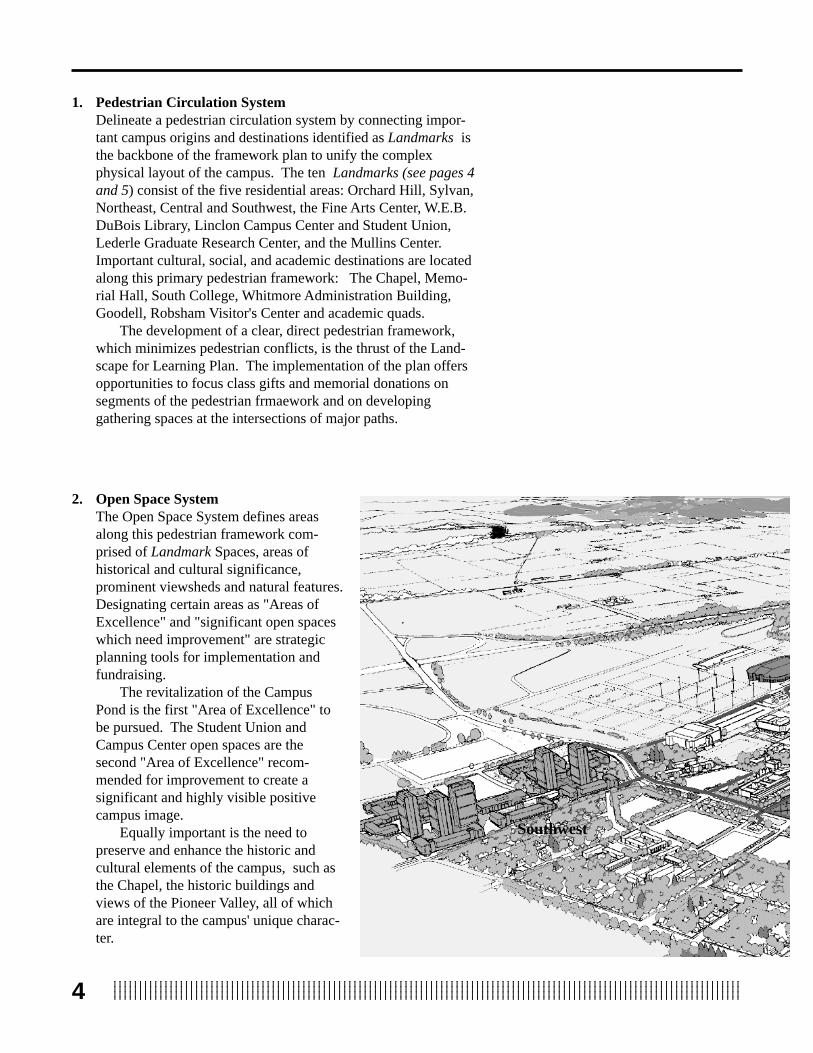
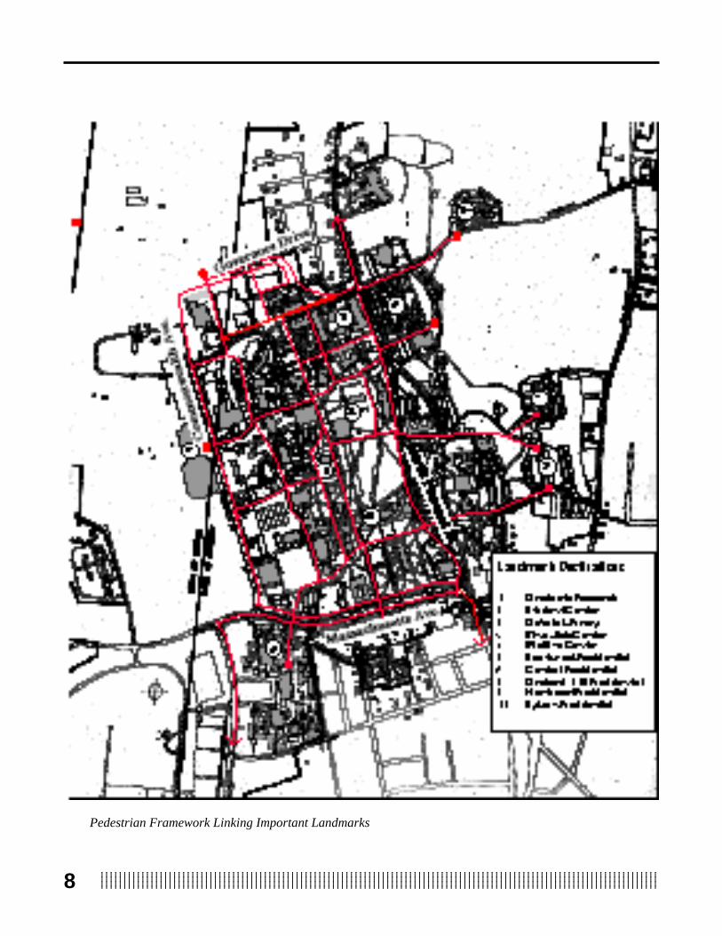
1. Pedestrian Circulation SystemDelineate a pedestrian circulation system by connecting impor-tant campus origins and destinations identified as Landmarks isthe backbone of the framework plan to unify the complexphysical layout of the campus. The ten Landmarks (see pages 4and 5) consist of the five residential areas: Orchard Hill, Sylvan,Northeast, Central and Southwest, the Fine Arts Center, W.E.B.DuBois Library, Linclon Campus Center and Student Union,Lederle Graduate Research Center, and the Mullins Center.Important cultural, social, and academic destinations are locatedalong this primary pedestrian framework: The Chapel, Memo-rial Hall, South College, Whitmore Administration Building,Goodell, Robsham Visitor's Center and academic quads.
The development of a clear, direct pedestrian framework,which minimizes pedestrian conflicts, is the thrust of the Land-scape for Learning Plan. The implementation of the plan offersopportunities to focus class gifts and memorial donations onsegments of the pedestrian frmaework and on developinggathering spaces at the intersections of major paths.
Southwest
2. Open Space SystemThe Open Space System defines areasalong this pedestrian framework com-prised of Landmark Spaces, areas ofhistorical and cultural significance,prominent viewsheds and natural features.Designating certain areas as "Areas ofExcellence" and "significant open spaceswhich need improvement" are strategicplanning tools for implementation andfundraising.
The revitalization of the CampusPond is the first "Area of Excellence" tobe pursued. The Student Union andCampus Center open spaces are thesecond "Area of Excellence" recom-mended for improvement to create asignificant and highly visible positivecampus image.
Equally important is the need topreserve and enhance the historic andcultural elements of the campus, such asthe Chapel, the historic buildings andviews of the Pioneer Valley, all of whichare integral to the campus' unique charac-ter.
512345678901234567890123456789012123456789012345678901234567890121234567890123456789012345678901212345678901234567890123456781234567890123456789012345678901212345678901234567890123456789012123456789012345678901234567890121234567890123456789012345678123456789012345678901234567890121234567890123456789012345678901212345678901234567890123456789012123456789012345678901234567812345678901234567890123456789012123456789012345678901234567890121234567890123456789012345678901212345678901234567890123456781234567890123456789012345678901212345678901234567890123456789012123456789012345678901234567890121234567890123456789012345678
Mullins Center
Pond
Sylvan
Campus Center
Visitors Center
Open SpaceClassification
Undefined
Designed
Recreational
Forested Areas
Fine Arts Center
W.E.B. DuBoisLibrary
Lederle GraduateResearch Center
Central
Northeast
Orchard Hill
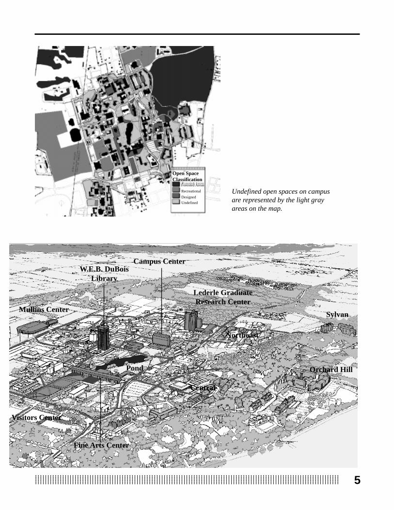
Undefined open spaces on campusare represented by the light grayareas on the map.

123456789012345678901234567890121234567890123456789012345678901212345678901234567890123456789012123456789012345678901234567812345678901234567890123456789012123456789012345678901234567890121234567890123456789012345678901212345678901234567890123456781234567890123456789012345678901212345678901234567890123456789012123456789012345678901234567890121234567890123456789012345678123456789012345678901234567890121234567890123456789012345678901212345678901234567890123456789012123456789012345678901234567812345678901234567890123456789012123456789012345678901234567890121234567890123456789012345678901212345678901234567890123456786
3. Waugh ArboretumThe Waugh Arboretum will be re-established and used as the theme toguide landscape development.President Baker saw the importanceof designating a portion of thecampus as an Arboretum in 1944,both to recognize the efforts of FrankA. Waugh in bringing a variety ofplant specimens to the campus and asa way to preserve indigenous NewEngland plants.
An Arboretum Master Plan willdesignate the entire campus as anarboretum and build on existing plantcommunities. The arboretum willprovide the theme for future land-scape planting which will definepedestrian corridors and open spacesand support teaching and research. Aplanned Arboretum Research andVisitors Center on Orchard Hill willprovide a teaching and research assetfor the University and a regionaldestination for visitors, supportingthe concept of a "Landscape forLearning".
4. Vehicular Circulation and Parking SystemsThe Vehicular Circulation and Parking Systems are criticalcomponents for creating a pedestrian friendly environment byestablishing auto-free zones, designating service and deliveryaccess points and moving surface parking areas to the campusperimeter. Separating vehicular routes from pedestrian paths andlimiting service access points is the first step in implementing apedestrian zone for the campus core.
The cooperation of the Parking Office, Central Receiving,Mail Services and Physical Plant are integral to the success ofthe Campus Landscape plan. Funding a study to establish abicycle lane network within the campus, which connects to thefive-college bicycle system, is also a vital step toward producinga pedestrian friendly environment.
Service Roads
Vehicular Service Framework
ArboretumVisitorsCenter

712345678901234567890123456789012123456789012345678901234567890121234567890123456789012345678901212345678901234567890123456781234567890123456789012345678901212345678901234567890123456789012123456789012345678901234567890121234567890123456789012345678123456789012345678901234567890121234567890123456789012345678901212345678901234567890123456789012123456789012345678901234567812345678901234567890123456789012123456789012345678901234567890121234567890123456789012345678901212345678901234567890123456781234567890123456789012345678901212345678901234567890123456789012123456789012345678901234567890121234567890123456789012345678
5. Infill Development PatternsInfill Development Patterns should be viewed as elements thatstrengthen and reinforce the open space and pedestrian frame-work. By appropriately siting future buildings in close proximityto existing structures according to the framework plan, newspaces will be created that improve the open space system.Equally important is the need to designate a portion of each newbuilding’s budget to design and construct these spaces.
Infill Sites
The Composite of the pedestrian, open space and vehicularcirculaton systems indicates sites for infill development.

712345678901234567890123456789012123456789012345678901234567890121234567890123456789012345678901212345678901234567890123456781234567890123456789012345678901212345678901234567890123456789012123456789012345678901234567890121234567890123456789012345678123456789012345678901234567890121234567890123456789012345678901212345678901234567890123456789012123456789012345678901234567812345678901234567890123456789012123456789012345678901234567890121234567890123456789012345678901212345678901234567890123456781234567890123456789012345678901212345678901234567890123456789012123456789012345678901234567890121234567890123456789012345678
123456789012345678901234567890121234567890123456789012345678901212345678901234567890123456789012123456789012345678901234567812345678901234567890123456789012123456789012345678901234567890121234567890123456789012345678901212345678901234567890123456781234567890123456789012345678901212345678901234567890123456789012123456789012345678901234567890121234567890123456789012345678123456789012345678901234567890121234567890123456789012345678901212345678901234567890123456789012123456789012345678901234567812345678901234567890123456789012123456789012345678901234567890121234567890123456789012345678901212345678901234567890123456788
11
3
1
10
4
6
4
35
8
7
2
91
10
2 Student Center 1 Graduate Research
3 DuBois Library
5 Mullins Center6 Southwest Residential
7 Central Residential 8 Orchard Hill 9 Northeast Residential
Pedestrian Framework Linking Important Landmarks
4 Fine Arts Center

912345678901234567890123456789012123456789012345678901234567890121234567890123456789012345678901212345678901234567890123456781234567890123456789012345678901212345678901234567890123456789012123456789012345678901234567890121234567890123456789012345678123456789012345678901234567890121234567890123456789012345678901212345678901234567890123456789012123456789012345678901234567812345678901234567890123456789012123456789012345678901234567890121234567890123456789012345678901212345678901234567890123456781234567890123456789012345678901212345678901234567890123456789012123456789012345678901234567890121234567890123456789012345678
Background
Pedestrian circulation was identified in the 1993 Master Plan asone of the components most in need of improvement to providevisitors, prospective and enrolled students, and faculty and staff withan improved sense of orientation.
Visitors to the UMass Robsham Visitors Centerreceive a campus map locating buildings, but many findlocating the Campus Center, Admissions Office and otherbuildings difficult since clearly marked pedestrian andvehicular routes are not identified on the campus map.Visitors also complain about the lack of directional signswithin the campus core.
The current experience of walking across the UMasscampus consists of navigating a maze of disconnectedpaths, many in disrepair, while dodging service andmaintenance vehicles that use the same pedestrian pathsas delivery routes.
There is very little consistency to the path system;wide paved routes merge into narrow paths. The majornorth-south corridor which passes in front of the librarynarrows and jogs before linking with the Student Union.
Where major paths do intersect, there are no clearlydefined meeting or gathering areas. The paths whichcome together between Whitmore and Herter along thenorth-south corridor are an example of an ill-definedspace created by a maze of paths.
When the W.E.B. DuBois Library was built, anumber of construction paths were paved between theStudent Union and the Fine Arts Center, duplicatingtraffic flow and adding to the confusion of paths. Asimilar situation occurs on the north east side of theCampus Center, between Goessmann and Hasbrouck,where a maze of paths criss-cross the area. There is aninordinate amount of blacktop at this crossroads of
student activity. The GRC courtyard, Mullins Center, Silvio O.Conte entry, the Hills entry and Curry Hicks Cage entry provide thebest examples of the use of paving materials other than asphalt, tocreate an attractive sense of arrival and identity.
Visitors to the campus are often perplexed by the width ofcombined paths and service routes which appear to be roads, andinadvertently drive into the campus core. The driveway at the FineArts Plaza is not clearly marked for service or emergency vehiclesand visitors inappropriately enter the campus at this point.
The existing path system isunorganized and confusing
PedestrianCirculation
System

1234567890123456789012345678901212345678901234567890123456789012123456789012345678901234567890121234567890123456789012345678123456789012345678901234567890121234567890123456789012345678901212345678901234567890123456789012123456789012345678901234567812345678901234567890123456789012123456789012345678901234567890121234567890123456789012345678901212345678901234567890123456781234567890123456789012345678901212345678901234567890123456789012123456789012345678901234567890121234567890123456789012345678123456789012345678901234567890121234567890123456789012345678901212345678901234567890123456789012123456789012345678901234567810
Routes from residential areas to the campuscore are not clear and direct, but jog aroundbuildings, through parking lots and down treach-erous paths. The east-west pedestrian route, fromMorrill Courtyard to Orchard Hill, is one suchroute where students climb a rocky path to theirresidence hall. A paved road exists as an alterna-tive, however it curves around the hill, thusstudents choose the most direct route which isfrequently described as a “goat” path. The DurfeeGarden provides an excellent example of a welldesigned gathering space along this route.
Several decades of construction and the DutchElm disease destroyed a number of treelined roadswith pedestrian sidewalks, such as along NorthPleasant Street, diminishing the pedestrian experience through thecenter of campus
The sidewalks along Massachusetts Avenue and the two paths oneither side of Haigus Mall are the best examples of tree-lined walkson the campus. Each walk is planted with an allee of trees whichprovide the basis for an Arboretum quality environment.
Objective
Establish a Framework Plan for the campus landscape bydefining a Pedestrian Circulation System which unifies thecomplex physical layout of the campus.
The purpose of this study was to analyze the existing pedestriancirculation routes, identify major pathways between importantorigins and destinations, i.e. residence hall areas, academic districts,and student service areas, and to designate primary circulationcorridors which could provide the framework for the circulationsystem. To provide clear, legible pedestrian routes was the primarygoal, followed by the development of policies, standards, and designrecommendations to implement the framework plan.
Sidewalks in front of Whitmoreare the best example of well-designed tree lined walks oncampus.
The numerous paths by the CampusPond should be consolidated into aclear pedestrian system.
Students choose the most directroutes creating "Goat Paths" asshown in front of the LincolnCampus Center.
1112345678901234567890123456789012123456789012345678901234567890121234567890123456789012345678901212345678901234567890123456781234567890123456789012345678901212345678901234567890123456789012123456789012345678901234567890121234567890123456789012345678123456789012345678901234567890121234567890123456789012345678901212345678901234567890123456789012123456789012345678901234567812345678901234567890123456789012123456789012345678901234567890121234567890123456789012345678901212345678901234567890123456781234567890123456789012345678901212345678901234567890123456789012123456789012345678901234567890121234567890123456789012345678
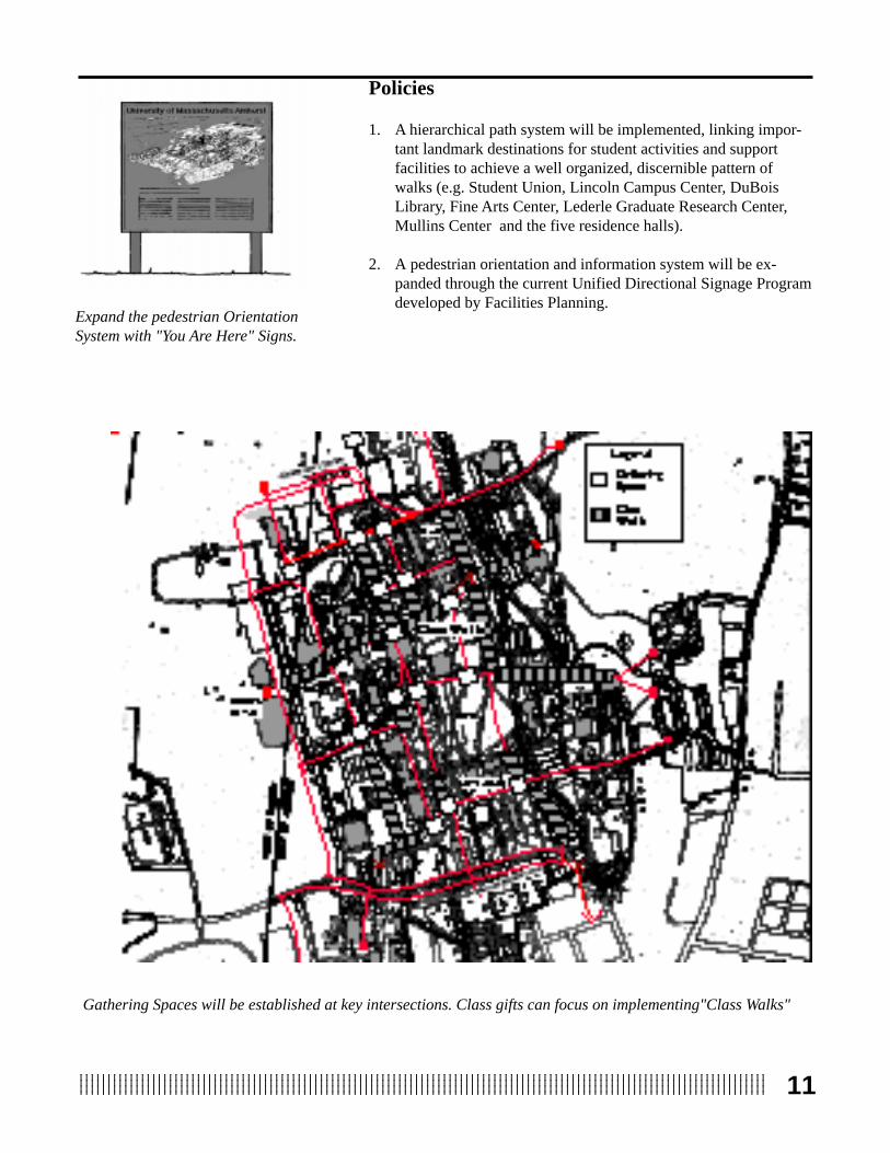
Gathering Spaces will be established at key intersections. Class gifts can focus on implementing"Class Walks"
Policies
1. A hierarchical path system will be implemented, linking impor-tant landmark destinations for student activities and supportfacilities to achieve a well organized, discernible pattern ofwalks (e.g. Student Union, Lincoln Campus Center, DuBoisLibrary, Fine Arts Center, Lederle Graduate Research Center,Mullins Center and the five residence halls).
2. A pedestrian orientation and information system will be ex-panded through the current Unified Directional Signage Programdeveloped by Facilities Planning.
Massachusetts AveMassachusetts Ave
Expand the pedestrian OrientationSystem with "You Are Here" Signs.

1234567890123456789012345678901212345678901234567890123456789012123456789012345678901234567890121234567890123456789012345678123456789012345678901234567890121234567890123456789012345678901212345678901234567890123456789012123456789012345678901234567812345678901234567890123456789012123456789012345678901234567890121234567890123456789012345678901212345678901234567890123456781234567890123456789012345678901212345678901234567890123456789012123456789012345678901234567890121234567890123456789012345678123456789012345678901234567890121234567890123456789012345678901212345678901234567890123456789012123456789012345678901234567812
Recommendations
• Adopt the proposed Pedestrian Framework Plan defining majorpedestrian corridors that provide linkages between LandmarkDestinations.
• Designate major pedestrian intersections as areas of specialinterest for which designed gathering spaces will be provided.
• Designate sites along the major East-West pedestrian route fromthe Student Union through Morrill Courtyard to Orchard Hill forcampus image improvement.
• Implement segments of the pedestrian framework system byfocusing class gifts and memorial donations on locations identi-fied as areas of special interest, pedestrian system intersectionsand campus image improvement projects.
• Endorse the development of design guidelines which specify alandscape palette of paving materials, site amenities and plantingelements for pedestrian walkways and intersections, designedlandscapes and building entries and courtyards.
• Develop a Campus Map which provides orientation informationfrom the visitor’s center and other key areas of campus. Coordi-nate these efforts with Physical Plant to complement the signageprogram.
Student Union spaces will beimproved as part of the CampusPond Project to become the next"Area of Excellence"

1312345678901234567890123456789012123456789012345678901234567890121234567890123456789012345678901212345678901234567890123456781234567890123456789012345678901212345678901234567890123456789012123456789012345678901234567890121234567890123456789012345678123456789012345678901234567890121234567890123456789012345678901212345678901234567890123456789012123456789012345678901234567812345678901234567890123456789012123456789012345678901234567890121234567890123456789012345678901212345678901234567890123456781234567890123456789012345678901212345678901234567890123456789012123456789012345678901234567890121234567890123456789012345678
• Expand the sign program to include signs indicating pedestrianpaths vs. vehicular/service routes.
• Selectively remove unnecessary paths which are not part of theframework plan and convert them to designed landscapes.
• Improve the pedestrian route along Commonwealth Ave to theMullins Center.
• Separate bicycle traffic from pedestrian paths to the extentpossible.
Endorse the development of designguidelines defining plantingelements along pedestrian walkways

1312345678901234567890123456789012123456789012345678901234567890121234567890123456789012345678901212345678901234567890123456781234567890123456789012345678901212345678901234567890123456789012123456789012345678901234567890121234567890123456789012345678123456789012345678901234567890121234567890123456789012345678901212345678901234567890123456789012123456789012345678901234567812345678901234567890123456789012123456789012345678901234567890121234567890123456789012345678901212345678901234567890123456781234567890123456789012345678901212345678901234567890123456789012123456789012345678901234567890121234567890123456789012345678

1234567890123456789012345678901212345678901234567890123456789012123456789012345678901234567890121234567890123456789012345678123456789012345678901234567890121234567890123456789012345678901212345678901234567890123456789012123456789012345678901234567812345678901234567890123456789012123456789012345678901234567890121234567890123456789012345678901212345678901234567890123456781234567890123456789012345678901212345678901234567890123456789012123456789012345678901234567890121234567890123456789012345678123456789012345678901234567890121234567890123456789012345678901212345678901234567890123456789012123456789012345678901234567814
Campus Core Spaces that need improvement
Governors Drive
Massachusetts Ave
Com
mon
wea
lth
Ave
Tow
n of
Am
hers
t
Tow
n of
Had
ley
Nor
th P
leas
ant

1512345678901234567890123456789012123456789012345678901234567890121234567890123456789012345678901212345678901234567890123456781234567890123456789012345678901212345678901234567890123456789012123456789012345678901234567890121234567890123456789012345678123456789012345678901234567890121234567890123456789012345678901212345678901234567890123456789012123456789012345678901234567812345678901234567890123456789012123456789012345678901234567890121234567890123456789012345678901212345678901234567890123456781234567890123456789012345678901212345678901234567890123456789012123456789012345678901234567890121234567890123456789012345678
Background
The improvement of campus open spaces was another compo-nent identified by the 1993 Campus Physical Master Plan as vital toenhancing the physical and visual quality of the campus. Theaesthetic character of the campus and the ability for active andpassive recreational opportunities are critical factors which influenceprospective students’ college choices as indicated by the 1984Carnegie Foundation for the Advancement of Teaching Report.(Change: Trendlines, Jan/Feb 1986) Based on a survey of prospec-tive college students to determine how they selected a college, 50%listed the campus visit as the decisive factor and 62% reported thatthe appearance of the grounds and buildings influenced them mostduring these campus visits.
An analysis of the open spaces on campus reveals that most ofthe spaces within the campus core have not been designed in con-junction with building development, but are unused land parcels thatare termed "unimproved" . Spaces around the Student Union and theLincoln Campus Center, spaces between Herter and Whitmore, andthe spaces between the Engineering Quad and Goessmann represent
such undefined open spaces. Thespaces between and around thesebuildings have not been addressed aspart of a coherent campus plan whichidentifies spaces associated withacademic clusters or student activitycenters. In contrast, the Haigis Mall,Lederle Graduate Research Centerand Silvio O. Conte Courtyards,Morrill Courtyard, the Fine ArtsCenter plaza, Mullins Center court-yard and Durfee Garden are ex-amples of designed open spaces.
The campus is dominated byundefined open spaces which arerepresented by the light gray areason the map.
Forested AreasRecreational
Designed
Open SpaceClassification
Undefined
Durfee Garden is an excellentexample of a designed open space.
Open SpaceSystem

1234567890123456789012345678901212345678901234567890123456789012123456789012345678901234567890121234567890123456789012345678123456789012345678901234567890121234567890123456789012345678901212345678901234567890123456789012123456789012345678901234567812345678901234567890123456789012123456789012345678901234567890121234567890123456789012345678901212345678901234567890123456781234567890123456789012345678901212345678901234567890123456789012123456789012345678901234567890121234567890123456789012345678123456789012345678901234567890121234567890123456789012345678901212345678901234567890123456789012123456789012345678901234567816
The courtyard between the high-rise and low-rise LederleGraduate Research Center has recently been effectively planted,however, this inviting space does not provide a seating area. TheSilvio O. Conte Polymer building courtyard is a good example of anew building with a thoughtfully designed entry that provides agathering space including ample seating.
The Mullins Center provides several benches at the entry, but notnearly enough to accomodate people meeting for an event. TheMorrill Courtyard and Fine Arts Center Plaza do not provide seatingareas, although the concrete edge of the reflecting pond provides alow bench for people waiting at the bus stop.
The Student Union plaza on the south side facing the pond willbe redesigned as part of the Campus Pond Project to provide animproved gathering area. However, the other spaces around theStudent Union i.e. the main entry and the Metawampee Lawn, do notprovide seating areas and are not designed to accommodate the largenumber of students meeting at this crossroads of the campus. TheLincoln Campus Center terraces and steps are also prime gatheringspaces; however, students are deterred from using this area due to thestrong, unshaded southern exposure. The sloped grassy area facingthe east entry of the Lincoln Student Center has become an invitingsocial area. The large expanse of asphalt at the east entry does notcomplement the design of this entry node.
Some formal spaces for active and passive recreation have been
designed within the Southwest and Orchard Hill complexes, how-ever, most open areas within and around housing and residentialareas have not been planned or designed for recreational and socialgatherings. Existing recreational facilities in the Northeast andSouthwest residence areas consist of either a single basketball courtor a volleyball court, but do not provide any other facililities toaccommodate a range of recreational activities. It is the manyunimproved spaces that are currently being used for this function.Residents of the Orchard Hill area have established running paths inthe undeveloped northeast areas.
The recreational space at theNortheast Residential Area consistsof a single volleyball area. Morerecreational spaces should beprovided.
The Student Union South Courtyardwill be improved as part of theCampus Pond Project.
The Engineering Quad is a definedOpen Space that is currentlyunimproved.
The Mullins Center Courtyard is awell designed open space, howeveradequate seating for gathering isnot provided.

1712345678901234567890123456789012123456789012345678901234567890121234567890123456789012345678901212345678901234567890123456781234567890123456789012345678901212345678901234567890123456789012123456789012345678901234567890121234567890123456789012345678123456789012345678901234567890121234567890123456789012345678901212345678901234567890123456789012123456789012345678901234567812345678901234567890123456789012123456789012345678901234567890121234567890123456789012345678901212345678901234567890123456781234567890123456789012345678901212345678901234567890123456789012123456789012345678901234567890121234567890123456789012345678
Formal recreational open spaces exist aspart of the athletic complex behind theMullins Center and adjacent to the gymna-sium facilities, however, other recreationalareas within the core, both formal and infor-mal, have not been planned. Forested areasmainly exist on the Northwest section of thecampus and will be preserved as part of theframework for the Waugh Arboretum.
Objective
Establish a comprehensive Open Space System, incorporat-ing developed and managed natural open spaces, which providethe context and physical setting for implementing all futuredevelopment.
The purpose of this objective is to identify unimproved spaceswhich should become formal or informal designed open spaces, toidentify historic areas which should be enhanced or preserved, and toidentify areas which should be managed natural spaces. The planrecommends targeting specific spaces as Areas of Excellence forwhich funds can be allocated to improve the campus image. TheAreas of Excellence may be designed open spaces, historic areas ormanaged natural areas.
Whitmore Courtyard represents a well-designed open space.
Formal recreational areasshould be preserved as open spaces.

1234567890123456789012345678901212345678901234567890123456789012123456789012345678901234567890121234567890123456789012345678123456789012345678901234567890121234567890123456789012345678901212345678901234567890123456789012123456789012345678901234567812345678901234567890123456789012123456789012345678901234567890121234567890123456789012345678901212345678901234567890123456781234567890123456789012345678901212345678901234567890123456789012123456789012345678901234567890121234567890123456789012345678123456789012345678901234567890121234567890123456789012345678901212345678901234567890123456789012123456789012345678901234567818
Seating Area at Sylvan Residential Hall.
7. To the extent possible, remove "negative icons" from the campuscore.
The Silvio O. Conte PolymerResearch Building entry courtyardis a well defined open space forgathering.
The Campus Pond represents amanaged natural area.
More gathering spaces need to beprovided on campus.
Policies
1. A well defined system of designed open spaces adjacent tocampus landmark destinations will be provided. (i.e. W.E.B.DuBois Library Courtyard, Student Union Terrace andMetawampee Lawn, Lincoln Campus Center entries, Fine ArtsPlaza and Graduate Research Center Courtyards)
2. Funds will be allocated and fundraising prioritized to enhanceAreas of Excellence, important locations on campus that arehighly visible, and make them showpieces. (The Campus Pondbeing the first area targeted for enhancement)
3. Historic landmarks will be preserved.
4. Managed natural spaces and significant vistas where no develop-ment can occur except for receation will be designated forpreservation and conservation to guarantee their long termprotection.
5. Recreational open spaces will be maintained in close proximityto housing/residential areas. Jogging paths will be provided as arecreational and athletic component.
6. Intramural fields will be maintained for recreational use topreserve the positive image of the western edge of campus.

1912345678901234567890123456789012123456789012345678901234567890121234567890123456789012345678901212345678901234567890123456781234567890123456789012345678901212345678901234567890123456789012123456789012345678901234567890121234567890123456789012345678123456789012345678901234567890121234567890123456789012345678901212345678901234567890123456789012123456789012345678901234567812345678901234567890123456789012123456789012345678901234567890121234567890123456789012345678901212345678901234567890123456781234567890123456789012345678901212345678901234567890123456789012123456789012345678901234567890121234567890123456789012345678
The W.E.B. DuBois Library Courtyard needs to be improved toprovide an attractive seating and study area.
Expand Recreational facilities at all campus residential areas.
Relocate the bus stop from the FineArts Plaza to enhance the image ofthis potential "Area of Excellence".
The Lincoln Campus Centercontains designed open spaces inneed of improvement.
Recommendations
• Designate the Student Union entry as the next Area of Excel-lence where funds can be focused to create a positive campusimage.
• Designate the Fine Arts Plaza and Haigis Mall as an Area ofExcellence to be improved; relocate the bus stop .
• Designate the following unimproved areas as open spaces to bedesigned within the campus core: Engineering Quad,Goessmann entry and side yard, Stockbridge entry and backyard, Bartlett-Goodell entry, Memorial Hall east entry, SouthCollege entry, Thompson entry and Morrill frontage.
• Designate the following areas as designed open spaces in urgentneed of improvement: Lincoln Campus Center west entry,Campus Hotel entry courtyard, W.E.B. DuBois Library court-yards, Thompson-Machmer area and Goodell-Chapel area.
• Designate the following buildings as Historical/Cultural Re-sources: The Chapel, Memorial Hall, South College, WilderHall, East and West Experiment Station , Munson and theFaculty Club.
• Enhance the recreational facilities at each of the five residentialareas in association with the Housing Office Capital Plan.
• Develop a cross-country running and ski network connecting theNorth Campus, the Southwest dorms, and the Orchard Hill areawith a perimeter trail around the campus.
• Remove "negative icons" such as the library fencing and trashbarrels at building entries.

1912345678901234567890123456789012123456789012345678901234567890121234567890123456789012345678901212345678901234567890123456781234567890123456789012345678901212345678901234567890123456789012123456789012345678901234567890121234567890123456789012345678123456789012345678901234567890121234567890123456789012345678901212345678901234567890123456789012123456789012345678901234567812345678901234567890123456789012123456789012345678901234567890121234567890123456789012345678901212345678901234567890123456781234567890123456789012345678901212345678901234567890123456789012123456789012345678901234567890121234567890123456789012345678

1234567890123456789012345678901212345678901234567890123456789012123456789012345678901234567890121234567890123456789012345678123456789012345678901234567890121234567890123456789012345678901212345678901234567890123456789012123456789012345678901234567812345678901234567890123456789012123456789012345678901234567890121234567890123456789012345678901212345678901234567890123456781234567890123456789012345678901212345678901234567890123456789012123456789012345678901234567890121234567890123456789012345678123456789012345678901234567890121234567890123456789012345678901212345678901234567890123456789012123456789012345678901234567820
Proposed Arboretum Center
Waugh Arboretum Center

2112345678901234567890123456789012123456789012345678901234567890121234567890123456789012345678901212345678901234567890123456781234567890123456789012345678901212345678901234567890123456789012123456789012345678901234567890121234567890123456789012345678123456789012345678901234567890121234567890123456789012345678901212345678901234567890123456789012123456789012345678901234567812345678901234567890123456789012123456789012345678901234567890121234567890123456789012345678901212345678901234567890123456781234567890123456789012345678901212345678901234567890123456789012123456789012345678901234567890121234567890123456789012345678
Background
While the existing arboretum on campus is historically signifi-cant, it is in a state of decline. If properly developed and maintained,the Waugh Arboretum has the potential to become an important partof the organizing framework for the campus landscape. In addition,it can become a significant arboretum which will be an educationaland economic asset for the University, for the region and for theCommonwealth.
The arboretum has existed on campus for over one hundredyears. During his 1867-1879 tenure as the University’s third presi-dent, William Clark traveled to Hokkaido, Japan to establish anagricultural university and he returned to Amherst with Japaneseplant specimens. Among these were several original introductionswhich have been credited to Clark. As the cross-cultural relationshipbetween the two universities flourished, so did the collection ofplants Clark collected on subsequent visits. Clark and his successor,Dr. Brooks, brought back a number of horticulturally outstandingJapanese plants toward the end of the 19th century, many of whichcomprise the backbone of the strong Asian presence in the arboretumtoday.
Interest in the campus arboretum continued under the eye ofFrank A. Waugh, head of the landscape architecture department inthe early 20th century. He had a vision of a picturesque campuswhere the buildings should blend with the agricultural landscape.This vision reflects the founding philosophy of the college, that theland was more important than the buildings. In 1944, after Waugh’sdeath, President Baker recommended that certain areas of campus beset aside for development of the Waugh Arboretum and that theirdevelopment be under the supervision of the Department of Land-scape Architecture. It was voted to authorize the establishment ofthe Waugh Arboretum as recommended by the President andMassachusetts State College officially recognized the campusarboretum as a memorial to Waugh and his contribution to thecampus landscape.
Although the arboretum is historically significant, it is notpublicized or promoted by the University. Therefore its potential forcontribution to the University and the community has been dimin-ished. A more thoroughly developed arboretum will be an educa-tional, cultural and aesthetic resource for the University and thecommunity. As a regional destination, the arboretum could alsobecome an economic asset for the University.Historic Durfee Conservatory was
one of the first buildings on theMassachusetts Agricultural CollegeCampus.
Frank A. Waugh, namesakeof the Campus Arboretum.
WaughArboretum

1234567890123456789012345678901212345678901234567890123456789012123456789012345678901234567890121234567890123456789012345678123456789012345678901234567890121234567890123456789012345678901212345678901234567890123456789012123456789012345678901234567812345678901234567890123456789012123456789012345678901234567890121234567890123456789012345678901212345678901234567890123456781234567890123456789012345678901212345678901234567890123456789012123456789012345678901234567890121234567890123456789012345678123456789012345678901234567890121234567890123456789012345678901212345678901234567890123456789012123456789012345678901234567822
Objective
Provide an organizing theme for the campus landscapewhich supports teaching and research, defines the qualityand character of open spaces and promotes the historicaland cultural image of the University.
The objective of the development of the Waugh Arboretum is toprovide a “green framework” which connects Landmark Destinationsand defines key open spaces. The campus core arboretum will berevived and further developed and an Arboretum Visitors Center onOrchard Hill will support teaching and research activities.
Policies
1. The Waugh Arboretum and the Arboretum Visitors Center willprovide a “landscape for learning” for the University and thegeneral public.
2. A Master Plan will be the organizing tool for the arboretum. Alladditions to the arboretum must conform to and support theArboretum Master Plan.
3. Several planting standards will be reinforced to establish land-scape consistency and unity throughout the campus.
4. An Arboretum Advisory Board will be established as a decision-making body to direct and oversee the arboretum. By-laws willbe written and followed as the guiding philosophy of, andobjectives for, the arboretum.
A "Green Framework " connectsLandmark Destinations and defineskey open spaces. Tree-lines roadsdefine the campus core.
Orchard Hill, the proposed site ofthe Arboretum Visitor's Center.

2312345678901234567890123456789012123456789012345678901234567890121234567890123456789012345678901212345678901234567890123456781234567890123456789012345678901212345678901234567890123456789012123456789012345678901234567890121234567890123456789012345678123456789012345678901234567890121234567890123456789012345678901212345678901234567890123456789012123456789012345678901234567812345678901234567890123456789012123456789012345678901234567890121234567890123456789012345678901212345678901234567890123456781234567890123456789012345678901212345678901234567890123456789012123456789012345678901234567890121234567890123456789012345678
Recommendations
• Re-establish the Waugh Arboretum as the framework for land-scape plans and projects which define plant palettes and plantcommunities to guide landscape development.
• Establish the Arboretum Advisory Board to prepare a missionstatement, develop goals and objectives, develop by-laws andprocedures for coordinating with the campus on developmentdecisions.
• The Arboretum Advisory Board of approximately eight to twelvemembers should consist of a diverse consortium of memberswith arboretum or horticulture affiliations, including faculty,students and corporate leaders, Amherst/Hadley representatives,University alumni and a Chancellor’s office representative.
• Review and approve Arboretum Advisory Board Charter/ By-laws and make initial appointments.
• Prepare a Master Plan for the Arboretum.
• Develop plans for the Waugh Arboretum Visitors Center andResearch Center as a teaching asset for the University and aregional destination for visitors.
• The arboretum will serve as a living laboratory for Five-Collegeand University research in landscape architecture, botany,horticulture, forestry, ecological restoration and plant sciencesand a resource center for external professionals such as land-scape architects, nursery professionals, and amateur gardeners.
• Develop arboretum themes which may include grouping plantsaccording to genus, plant communities or habitat requirements.
• Develop landscape standards which use plants to accentuatebuilding entrances, control movement and define linear zones,serve as screens for parking and dumpsters etc.
• Develop arboretum guidelines for memorial gifts and class trees,addressing issues of species selection, planting location andassociated monuments.
The Japanese Elm at South College isthe oldest specimen in the USA.
Well placed plantings define anentrance on campus.
Plantings can be effectively used toscreen outdoor equipment.

2312345678901234567890123456789012123456789012345678901234567890121234567890123456789012345678901212345678901234567890123456781234567890123456789012345678901212345678901234567890123456789012123456789012345678901234567890121234567890123456789012345678123456789012345678901234567890121234567890123456789012345678901212345678901234567890123456789012123456789012345678901234567812345678901234567890123456789012123456789012345678901234567890121234567890123456789012345678901212345678901234567890123456781234567890123456789012345678901212345678901234567890123456789012123456789012345678901234567890121234567890123456789012345678

1234567890123456789012345678901212345678901234567890123456789012123456789012345678901234567890121234567890123456789012345678123456789012345678901234567890121234567890123456789012345678901212345678901234567890123456789012123456789012345678901234567812345678901234567890123456789012123456789012345678901234567890121234567890123456789012345678901212345678901234567890123456781234567890123456789012345678901212345678901234567890123456789012123456789012345678901234567890121234567890123456789012345678123456789012345678901234567890121234567890123456789012345678901212345678901234567890123456789012123456789012345678901234567824
Proposed Vehicular and Service Circulation in relationship to Landmark s
2512345678901234567890123456789012123456789012345678901234567890121234567890123456789012345678901212345678901234567890123456781234567890123456789012345678901212345678901234567890123456789012123456789012345678901234567890121234567890123456789012345678123456789012345678901234567890121234567890123456789012345678901212345678901234567890123456789012123456789012345678901234567812345678901234567890123456789012123456789012345678901234567890121234567890123456789012345678901212345678901234567890123456781234567890123456789012345678901212345678901234567890123456789012123456789012345678901234567890121234567890123456789012345678
Background
The 1993 Campus Physical Master Plan stressed that newfacilities be integrated into the campus core in a way that improvesexisting patterns of land use, open space, parking and circulation.The Plan further recommended establishing a clear sense of entryand arrival to the campus, extending the concept of the campus as apedestrian environment and limiting the land area devoted to parkingwithin the campus core.
Currently, arrival areas to the campus from the east at Massa-chusetts Avenue and North Pleasant Street, from the west at Route116, and from the north at Governors Drive and North PleasantStreet are designated by brick architectural signs which identifycampus destinations and events. These signs were installed in 1993as the first phase of the Directional Signage Program to identify themajor gateways to the UMass Campus. The two entrances to thecampus from East Pleasant Street do not have gateway signs.
One of the major arrival destinations on campus is the LincolnCampus Center. The entrance is currently marked by an olderdirectional sign at Commonwealth Avenue and the actual entrance isan underground passageway via the parking garage. Many visitorsand returning alumni have specifically cited this arrival area as onethat needs improvement.
To develop a new pedestrian and open space system for thecampus, the problem of service, vendor delivery, and maintenancevehicles traveling on walkways and parking in gathering spaces mustfirst be addressed. Currently, service vehicles travel freely on pedes-trian paths and park in building plazas, entries and on planted areas.The problem is two-fold: safety issues occur from vehicles travelingon pedestrian paths and planted spaces incur damage from vehicles.
VehicularCirculationand Parking
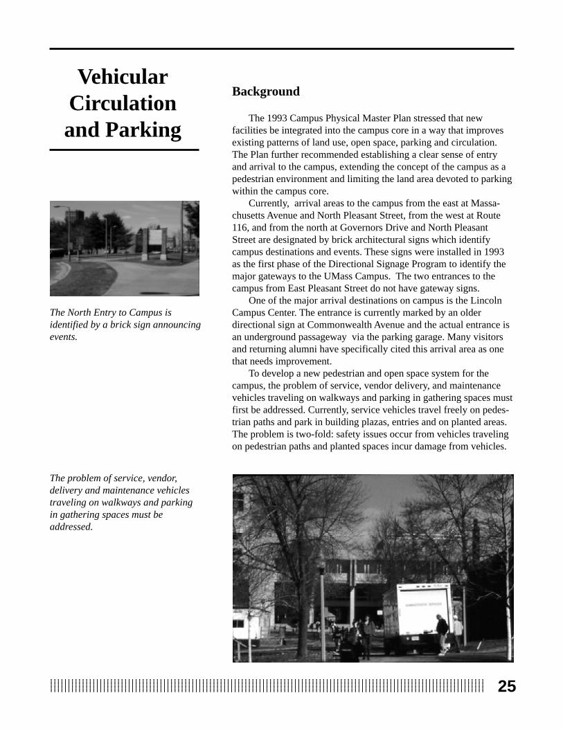
The North Entry to Campus isidentified by a brick sign announcingevents.
The problem of service, vendor,delivery and maintenance vehiclestraveling on walkways and parkingin gathering spaces must beaddressed.

1234567890123456789012345678901212345678901234567890123456789012123456789012345678901234567890121234567890123456789012345678123456789012345678901234567890121234567890123456789012345678901212345678901234567890123456789012123456789012345678901234567812345678901234567890123456789012123456789012345678901234567890121234567890123456789012345678901212345678901234567890123456781234567890123456789012345678901212345678901234567890123456789012123456789012345678901234567890121234567890123456789012345678123456789012345678901234567890121234567890123456789012345678901212345678901234567890123456789012123456789012345678901234567826
Approximately 20 parking lots are located within the campuscore. The University's Division of Facilities Planning is coordinatinga study to evaluate the location, size, parking space configurationand validity of current lots. Lots such as #62 on North PleasantStreet are sparsely planted and devoid of vegetative screens, creatingan expanse of pavement and metal within the campus core. Theseparking areas impede pedestrian movement, interrupt direct circula-tion routes and bring more vehicles onto the campus core. Theparking lot behind the Robsham Visitor’s Center is a good exampleof parking screened by planting and located just outside the campuscore on a major vehicular route.
Objective
Promote a pedestrian friendly campus and environment byminimizing pedestrian and vehicular conflicts.
To establish a pedestrian friendly campus environment, manyfactors must be analyzed and integrated. Service vehicles, maildelivery and emergency vehicles must have clear routes establishedwhich incur the least possible conflict with pedestrian paths and havethe least penetration into the campus core. Where pedestrians andvehicles follow a similar route, clearly defined paths for each mustbe designed to minimize conflicts. Accommodating bicycle trafficwithin the core also requires designating bicycle lanes to protectpedestrians from cyclists, and cyclists from vehicles. Reroutingtraffic and establishing policies which enforce the exclusion ofvehicles from pedestrian routes and prevent parking in inappropriateareas requires the cooperation of many administrative units includ-ing: the Parking Office, Central Receiving, Campus Police andPhysical Plant.
The vision to enhance the quality of the campus environment byproviding clearly articulated paths, open spaces, bicycle paths andservice roads must also accommodate the convenience and efficiencyof servicing buildings, and other maintenance and delivery functions.
Twenty parking lots are locatedwithin the campus core. Lot #62 issparsely planted and devoid ofvegetative screening, creating anunattractive expanse of pavement.
Existing service routes are shown inlight gray and proposed serviceroutes in black. The Plan eliminatesmany service routes within theCampus.Service vehicles
travel freely onPedestrian Pathscreating issues ofsafety.

2712345678901234567890123456789012123456789012345678901234567890121234567890123456789012345678901212345678901234567890123456781234567890123456789012345678901212345678901234567890123456789012123456789012345678901234567890121234567890123456789012345678123456789012345678901234567890121234567890123456789012345678901212345678901234567890123456789012123456789012345678901234567812345678901234567890123456789012123456789012345678901234567890121234567890123456789012345678901212345678901234567890123456781234567890123456789012345678901212345678901234567890123456789012123456789012345678901234567890121234567890123456789012345678
Policies
1. Auto-free zones within the campus core will be designated andenforced. Only emergency vehicles will be allowed.
2. Pedestrian and vehicular conflicts within the campus core will beminimized to the extent possible.
3. Vehicular access points will be consolidated, service routes willbe established, and single access delivery locations to eachbuilding will be designated. Front door deliveries will be elimi-nated to the extent possible.
4. Service routes and delivery hours will be enforced with thecooperation of the Parking Office, Central Receiving and pro-curement vendors.
5. A bicycle path system, differentiated from pedestrian routes andvehicular traffic, will be established in areas where it is physi-cally appropriate and feasible. Bicycle storage areas will beprovided in close proximity to academic buildings and resi-dences.
6. To the extent it is feasible, all future parking within the campuscore, with the exception of handicapped parking, will be con-
Vehicular access points will be consolidated and service routeswill be established. Front door deliveries will be minimized
Pedestrian and vehicular conflictswithin the campus core will beminimized to the extent possible.
tained in parking structures. All other parking will be located onthe periphery of campus, within a ten minute walking radius ofthe core, except for designated short-term parking at the Visitor'sCenter.
Under the proposed policy, the areain gray would be auto-free andpedestrian-friendly within theCampus Core.

1234567890123456789012345678901212345678901234567890123456789012123456789012345678901234567890121234567890123456789012345678123456789012345678901234567890121234567890123456789012345678901212345678901234567890123456789012123456789012345678901234567812345678901234567890123456789012123456789012345678901234567890121234567890123456789012345678901212345678901234567890123456781234567890123456789012345678901212345678901234567890123456789012123456789012345678901234567890121234567890123456789012345678123456789012345678901234567890121234567890123456789012345678901212345678901234567890123456789012123456789012345678901234567828
Prototype plan for North Areaparking lot plantings that providesvegetative buffers to screen parkingareas from pedestrian view.
Existing parking lot screenplanting at the Robsham Visitor'sCenter.
Recommendations
• Adopt the auto-free zones identified by the plan which will beused exclusively for pedestrian travel, with the exception offire lanes.
• Adopt the plan for establishing new service and vehicularroutes which designate an auto-free zone within the campuscore, specifically protecting the Campus Pond area fromvehicular traffic.
• Remove existing service routes which are not part of the newservice plan.
• Provide a map indicating vehicular service routes and serviceentrances with daily parking passes; utilize the parking officeto make service drivers aware of these routes, delivery hoursand enforcement policies.
• Establish trash collection routes within service zones andlocate areas for dumpsters appropriately.
• Develop landscape standards for parking lots within thecampus core that incorporate planted berms and vegetativebuffers to screen parking areas from pedestrian view.
• Evaluate closing Stockbridge Road as a major thoroughfare aspart of a future Sub-Area Plan.
• Improve the gateway and major entry route to the CampusCenter at Campus Center Way in conjunction with improvementsto the Campus Center/Student Union exterior open spaces.
• Improve the entry from North Pleasant Street area to the campusin partnership with the Town of Amherst and private propertyowners.

2912345678901234567890123456789012123456789012345678901234567890121234567890123456789012345678901212345678901234567890123456781234567890123456789012345678901212345678901234567890123456789012123456789012345678901234567890121234567890123456789012345678123456789012345678901234567890121234567890123456789012345678901212345678901234567890123456789012123456789012345678901234567812345678901234567890123456789012123456789012345678901234567890121234567890123456789012345678901212345678901234567890123456781234567890123456789012345678901212345678901234567890123456789012123456789012345678901234567890121234567890123456789012345678
Provide bicycle racks at all majorbuildings and at residential areas.
• Plan for a Multi-Modal Transportation Center to provide perim-eter access efficiency and reduce future parking demand.
• Move campus core parking lots to the periphery to provide newopportunities for infill and open spaces.
• Provide bicycle racks at all major buildings and at residentialareas.
• Fund a study to develop a bicycle lane network within thecampus, separate from pedestrian paths and vehicular routes,which connects the University with the five-college bike system.
Graphic)
Improve the image of the North entryby creating a designed landscapeat the gateway sign.
Remove Campus Core parking lotsto the periphery to provide newopportunities for infill and open spaces.
Pedestrian Bike Auto Bike Pedestrian
Fund a study to develop a bicycle lane network within the campus,separate from pedestrian and vehicular routes to the extent possible.

2912345678901234567890123456789012123456789012345678901234567890121234567890123456789012345678901212345678901234567890123456781234567890123456789012345678901212345678901234567890123456789012123456789012345678901234567890121234567890123456789012345678123456789012345678901234567890121234567890123456789012345678901212345678901234567890123456789012123456789012345678901234567812345678901234567890123456789012123456789012345678901234567890121234567890123456789012345678901212345678901234567890123456781234567890123456789012345678901212345678901234567890123456789012123456789012345678901234567890121234567890123456789012345678

1234567890123456789012345678901212345678901234567890123456789012123456789012345678901234567890121234567890123456789012345678123456789012345678901234567890121234567890123456789012345678901212345678901234567890123456789012123456789012345678901234567812345678901234567890123456789012123456789012345678901234567890121234567890123456789012345678901212345678901234567890123456781234567890123456789012345678901212345678901234567890123456789012123456789012345678901234567890121234567890123456789012345678123456789012345678901234567890121234567890123456789012345678901212345678901234567890123456789012123456789012345678901234567830
Potential Infill Development Sites Within the Campus Core
Governors Drive
Massachusetts Ave
Com
mon
wea
lth
Ave
Tow
n of
Am
hers
t
Tow
n of
Had
ley
Nor
th P
leas
ant

3112345678901234567890123456789012123456789012345678901234567890121234567890123456789012345678901212345678901234567890123456781234567890123456789012345678901212345678901234567890123456789012123456789012345678901234567890121234567890123456789012345678123456789012345678901234567890121234567890123456789012345678901212345678901234567890123456789012123456789012345678901234567812345678901234567890123456789012123456789012345678901234567890121234567890123456789012345678901212345678901234567890123456781234567890123456789012345678901212345678901234567890123456789012123456789012345678901234567890121234567890123456789012345678
Background
The Campus Physical Master Plan cited infill, the integration ofnew academic facilities and resources within the campus core, as themajor concept for improving the physical character of the campus. Astrong system of pedestrian walkways and open spaces provides theframework for designating future development sites.
The Engineering Quad, established by the renovation of MarcusHall and the addition of the Knowles Engineering Building, illus-trates how thoughtfully placed buildings can define an academicopen space for student gathering. The courtyard space createdbetween the low rise and high rise buildings of Lederle GraduateResearch Center illustrates another area where a space has beensuccessfully defined by structures. The Silvio O. Conte PolymerBuilding has a designed entry space which also serves as a gatheringspace for students. However, these three examples are not the normwithin the campus core; more new infill sites need to incorporate thiskind of infill building placement.
Clearly defined paths which guide the location of buildings andthe spaces around them, should be direct routes which eliminateneedless asphalt “spaghetti” paths. Currently, as many as five roads/walks may connect or pass through an area such as the CampusCenter making it difficult to define its entry, arrival areas or court-yards.
One of the main distractions one views on campus is the place-ment of dumpsters and trash cans in relationship to building entries.The previous vehicular/service circulation framework recommendsscreening or moving dumpsters away from building entrances toimprove the overall aesthetic experience of people on campus. Theseare "negative icons" that should be addressed as a priority.
The lack of bicycle storage areas and the placement and appear-ance of existing racks are issues which need to be addressed in thecontext of comprehensive site furnishings. At some buildings, treebranches and railings are used to secure bikes. In most cases, un-sightly broken racks are located in close proximity to the entry doors,prohibiting the use of these areas as a gathering spaces.
Wilder Hall has a well-definedentrance.
One of the main distractions oncampus is the placement of dumpstersand trash cans in poor relationshipto building entrances.
The lack of bicycle storage areas needsto be addressed in the context ofcomprehensive site furnishings.
InfillDevelopment
Patterns

1234567890123456789012345678901212345678901234567890123456789012123456789012345678901234567890121234567890123456789012345678123456789012345678901234567890121234567890123456789012345678901212345678901234567890123456789012123456789012345678901234567812345678901234567890123456789012123456789012345678901234567890121234567890123456789012345678901212345678901234567890123456781234567890123456789012345678901212345678901234567890123456789012123456789012345678901234567890121234567890123456789012345678123456789012345678901234567890121234567890123456789012345678901212345678901234567890123456789012123456789012345678901234567832
Objective
Utilize the Framework Plan as a guide in identifying appro-priate sites for future infill development within the campuscore. View new buildings as elements that define, reinforceand strengthen spaces and corridors.
The concept of infill development is influenced by the overlay ofthe five components of the framework plan: the pedestrian circula-tion system, the campus open space system, the landscape andarboretum framework, the vehicular, service and parking configura-
Future Infill Development Sites are definedby an overlay of the Pedestrian, Vehicular,Open Space and Arboretum Systems.
Infill Areas as identified by the 1993 Campus Physical Master Plan.
tion and existing development patterns. The spaces created by thiscomposite framework are identified as potential development sites.

3312345678901234567890123456789012123456789012345678901234567890121234567890123456789012345678901212345678901234567890123456781234567890123456789012345678901212345678901234567890123456789012123456789012345678901234567890121234567890123456789012345678123456789012345678901234567890121234567890123456789012345678901212345678901234567890123456789012123456789012345678901234567812345678901234567890123456789012123456789012345678901234567890121234567890123456789012345678901212345678901234567890123456781234567890123456789012345678901212345678901234567890123456789012123456789012345678901234567890121234567890123456789012345678
Policies
1. New construction of academic facilities will occur within theprimary road system of the campus core.
2. All planning for new construction will designate a percentage ofthe budget for landscape amenities to define the areas aroundeach building.
3. A system of identifiable academic clusters will be established,e.g. College of Engineering Quad, with corresponding open/public spaces, to promote easy identification of destinations, tobuild community identities, and to facilitate fundraising.
4. Main entrances to buildings will be enhanced as gathering spacesfor students, faculty and staff.
Recommendations
• Adopt a policy to designate a portion of new constructionbudgets for site improvements including plantings, site amenitiesand infrastructure.
• Adopt the infill zones defined by the open space, pedestrian andvehicular circulation framework plan for future development.
• Develop plans to improve existing entry areas, courtyards andgathering spaces associated with academic clusters, incorporat-ing a specified palette of paving, plantings and site amenities.
Designate a percentage of newconstruction budgets for landscapesite improvements as at the Silvio O.Conte building entry.
Main entrances to buildings will beenhanced as gathering spaces, asat the Mullins entry court.
Enhance building entrances asgathering spaces, as at theGraduate Research Center.

1234567890123456789012345678901212345678901234567890123456789012123456789012345678901234567890121234567890123456789012345678123456789012345678901234567890121234567890123456789012345678901212345678901234567890123456789012123456789012345678901234567812345678901234567890123456789012123456789012345678901234567890121234567890123456789012345678901212345678901234567890123456781234567890123456789012345678901212345678901234567890123456789012123456789012345678901234567890121234567890123456789012345678123456789012345678901234567890121234567890123456789012345678901212345678901234567890123456789012123456789012345678901234567834

3512345678901234567890123456789012123456789012345678901234567890121234567890123456789012345678901212345678901234567890123456781234567890123456789012345678901212345678901234567890123456789012123456789012345678901234567890121234567890123456789012345678123456789012345678901234567890121234567890123456789012345678901212345678901234567890123456789012123456789012345678901234567812345678901234567890123456789012123456789012345678901234567890121234567890123456789012345678901212345678901234567890123456781234567890123456789012345678901212345678901234567890123456789012123456789012345678901234567890121234567890123456789012345678
2. Improve the pedestrian route along Commonwealth Avenue tothe Mullins Center.
Adopt a set of policies to establish a comprehensive campusFramework Plan delineating pedestrian circulation, openspaces, designed landscapes, vehicular circulation and infilldevelopment sites to unify the complex physical layout ofthe campus.
Pedestrian Circulation System
Immediate Action
1. Adopt the proposed pedestrian framework defining majorpedestrian corridors that provide linkges between LandmarkDestinations.
2. Designate major pedestrian intersections as areas of specialinterest for which designed gathering spaces will be provided.
3 Designate sites along the major east-west pedestrian corridor,from the Student Union through Morrill Courtyard to OrchardHill, for campus image improvement.
4. Implement segments of the pedestrian framework system byfocusing class gifts and memorial donations on locations identi-fied as areas of excellence, special interest, pedestrian systemintersections and as campus image projects.
5. Endorse the development of design guidelines which specify alandscape palette of paving materials, site amenities and plantingelements for pedestrian walkways and intersections, designedlandscapes and building entries and courtyards.
6. Develop a campus map which provides orientation informationfrom the Visitor’s Center and other key areas of campus. Coordi-nate these efforts with Physical Plant to complement the SignageMaster Plan.
7. Expand the sign program to include signs distinguishing pedes-trian-only paths from vehicular/service routes.
Future Action
1. Selectively remove unnecessary paths which are not part of theFramework Plan and convert them to designed landscapes.
StrategicRecommendations

1234567890123456789012345678901212345678901234567890123456789012123456789012345678901234567890121234567890123456789012345678123456789012345678901234567890121234567890123456789012345678901212345678901234567890123456789012123456789012345678901234567812345678901234567890123456789012123456789012345678901234567890121234567890123456789012345678901212345678901234567890123456781234567890123456789012345678901212345678901234567890123456789012123456789012345678901234567890121234567890123456789012345678123456789012345678901234567890121234567890123456789012345678901212345678901234567890123456789012123456789012345678901234567836
Open Space System
Immediate Action
1. Designate the Student Union area as the next Area of Excellencewhere campus funds can be focused to create a positive campusimage.
2. Designate the following undefined open spaces as open spaces tobe designed within the campus core: Engineering Quad,Goessmann entry and side yard, Stockbridge entry and rear yard.
3. Designate the following areas as designed open spaces in urgentneed of improvement: Lincoln Campus Center east and westentries, Campus Hotel entry courtyard and DuBois Librarycourtyards.
Future Action
1. Designate the Fine Arts Plaza and Haigis Mall as an Area ofExcellence to be improved; relocate the bus stop.
2 Expand or enhance recreational facilities associated with each ofthe five residential areas in association with the Housing OfficeCapital Plan.
3. Develop a cross-country running and ski network connecting theNorth Campus, the Southwest dorms and the Orchard Hill areaby establishing a perimeter trail around the campus.

3712345678901234567890123456789012123456789012345678901234567890121234567890123456789012345678901212345678901234567890123456781234567890123456789012345678901212345678901234567890123456789012123456789012345678901234567890121234567890123456789012345678123456789012345678901234567890121234567890123456789012345678901212345678901234567890123456789012123456789012345678901234567812345678901234567890123456789012123456789012345678901234567890121234567890123456789012345678901212345678901234567890123456781234567890123456789012345678901212345678901234567890123456789012123456789012345678901234567890121234567890123456789012345678
Waugh Arboretum
Immediate Action
1. Re-establish the Waugh Arboretum as the framework for land-scape plans and projects which define plant palettes and commu-nities and guide landscape development.
2. Establish the Arboretum Advisory Board to prepare a missionstatement, develop goals and objectives, develop by-laws andprocedures for interfacing with the campus on developmentdecisions.
Future Action
1. Prepare a Master Plan for the Waugh Arboretum.
2. Review and approve Arboretum Advisory Board Charter/ By-Laws and make permanent appointments.
3. Develop plans for the Waugh Arboretum Visitors Center andResearch Center as a teaching asset for the University and aregional destination for visitors.

1234567890123456789012345678901212345678901234567890123456789012123456789012345678901234567890121234567890123456789012345678123456789012345678901234567890121234567890123456789012345678901212345678901234567890123456789012123456789012345678901234567812345678901234567890123456789012123456789012345678901234567890121234567890123456789012345678901212345678901234567890123456781234567890123456789012345678901212345678901234567890123456789012123456789012345678901234567890121234567890123456789012345678123456789012345678901234567890121234567890123456789012345678901212345678901234567890123456789012123456789012345678901234567838
Vehicular Circulation and Parking
Immediate Action
1. Adopt the auto-free zones identified by the plan which will beexclusively for pedestrian travel, with the exception of fire lanes.
2. Adopt the plan for establishing new service/vehicular routeswhich designate an auto-free zone within the campus core,specifically protecting the Campus Pond area from vehiculartraffic.
3. Remove existing service routes which are not part of the newservice plan.
4. Provide a map indicating vehicular service routes and serviceentrances with daily parking passes; utilize the Parking Office tomake service drivers aware of these routes, delivery hours andenforcement policies.
5. Establish trash collection routes within service zones and locateareas for dumpsters appropriately screened from view.
6. Develop landscape standards for parking lots within the campuscore which incorporate planted berms and vegetative buffers toscreen parking areas from pedestrian view.
7 Provide bicycle racks at major buildings and at residential areas.
8. Improve the gateway and major entry route to the CampusCenter at Campus Center Way in conjunction with improvementsto the Campus Center/Student Union exterior open spaces.
Future Action
1. Fund a study to develop a bike lane network within the campus,separate from pedestrian paths and vehicular routes, whichconnects the University with the five-college bike system.
2. Plan for a Multi-Modal Transportation Center to provide perim-eter access efficiency and reduce future parking demand.
3. Move campus core parking lots to the periphery to provide newopportunities for infill and open spaces.
4. Improve the entry from North Pleasant Street area to the campusin partnership with the Town of Amherst.

3912345678901234567890123456789012123456789012345678901234567890121234567890123456789012345678901212345678901234567890123456781234567890123456789012345678901212345678901234567890123456789012123456789012345678901234567890121234567890123456789012345678123456789012345678901234567890121234567890123456789012345678901212345678901234567890123456789012123456789012345678901234567812345678901234567890123456789012123456789012345678901234567890121234567890123456789012345678901212345678901234567890123456781234567890123456789012345678901212345678901234567890123456789012123456789012345678901234567890121234567890123456789012345678
Infill Development Patterns
Immediate Action
1. Adopt a policy to designate a portion of new constructionbudgets for site improvements including plantings, site amenitiesand infrastructure.
2. Adopt the infill zones defined by the open space, pedestrian andvehicular circulation framework plan for future development .
Future Action
1. Develop plans to improve existing entry areas, courtyards andgathering spaces associated with academic clusters, incorporat-ing a specified palette of paving, plantings and site amenities.