Embed Size (px)
Citation preview

A Master Plan for the New River District of Baton Rouge M i c h a e l V a n V a l k e n b u r g h A s s o c i a t e s w i t h D a n a N u n e z B r o w n L a n d s c a p e A r c h i t e c t 2 0 0 3
Prepared for the Downtown Development District and Plan Baton Rouge with special thanks to :
Victor F. “Trey” Trahan, IIIRichard Preis/One River Place/LDH,LLC
Commercial Properties Development CorporationRichard F. Manship

Aerial of Downtown Baton Rouge 9/28/2003
Master Plan Study Area

A Master Plan for the New River District
of Baton Rouge M i c h a e l V a n V a l k e n b u r g h A s s o c i a t e s
w i t h D a n a N u n e z B r o w n L a n d s c a p e A r c h i t e c t
2 0 0 3
Project Statement Concept Diagram
Site PlanDetailed Site Plan
Lafayette StreetGarden Plaza Concept
Connecting StreetsRiver Road
Building Setbacks and Road Adjustments DiagramRiver Road Sketch A
Aerial Diagram
1-23-45-67-8
9-101112
13-1617-18
19-2021-22
Ta b l e o f C o n t e n t s
Prepared for the Downtown Development District and Plan Baton Rouge with special thanks to :
Victor F. “Trey” Trahan, III
Richard Preis/One River Place/LDH,LLC
Commercial Properties Development Corporation
Richard F. Manship

River Road Precedent image. Memorial Drive, Cambridge , MA1

Landscape as a Catalyst for the New River District of Baton Rouge
This Master Plan for the New River District of Baton Rouge recognizes the fundamental role that streets play in the life of American cities and provides a framework for transforming the riverfront of Baton Rouge into a vibrant and beautiful urban environment. The new pedestrian charm and character of the area will establish the River District as a distinct place within Baton Rouge and become an engine for future growth and development. This vision is rooted in long-term thinking and should be considered a positive investment in the future of the city. This investment, properly implemented and maintained, will create a beautiful urban landscape that will grow to become a treasured gift to the city of Baton Rouge for generations to come.
Principles
1. Unifying the River District The Master Plan proposed to use the new urban landscape conditions along River Road and Lafayette Street as connective spines linking existing and proposed cultural and landscape amenities. The State Capitol, the new Visitors Center and Desoto Park to the North, and the Old State Capitol and museums to the South are important cultural and landscape anchors that will give the River District a logical structure and help define it is as recognizable place within the city.
2. Establishing an Identity for River District The Master Plan structures the River District through the simple idea of establishing two streets that complement each other; River Road will become a robust tree-lined boulevard that will establish a new address as the “front door” of the city welcoming both residents and visitors. Lafayette Street will become a beautiful and vibrant pedestrian-oriented street, fostering year round activity and social interaction, creating a place within the River District that people will want to work and live in. The dramatic enhancement of the landscape within the district by itself will immediately establish the River District as a distinct place within the city and the climate, culture and Mississippi River landscape will provide a strong basis for strengthening the character and identity of the River District.
3. Implementing a New Urban Landscape
This proposal establishes a simple and pragmatic framework that can be implemented incrementally over time. The framework is a landscape-based development strategy designed to work in conjunction with private development efforts that will allow the landscape improvements to help shape future development and urban investment within the River District. By following the guidelines set forth in the Master Plan, new development can be confident in making meaningful and coordinated contributions to the improvement of the city and be assured of a seamless connection to urban landscape of the River District. This will harness private investment as a tool for implementing the Master Plan and create a mutually beneficial situation for the city and private development.
4. Creating a Landscape Platform to Grow a Beautiful City Central to the thinking that has shaped the Master Plan is the establishment of both the subsurface and above-ground conditions needed to grow large, healthy canopy trees within the River District. Once this “platform” is established and the trees have been planted, it is essential to the success of the project that the trees receive proper maintenance and care. The establishment of these conditions within the framework of the Master Plan will create a beautiful urban environment in which both nature and city can thrive together to enrich the lives of the citizens of Baton Rouge.
2

Baton Rouge River District Master PlanM i c h a e l V a n V a l k e n b u r g h A s s o c i a t e s w i t h D a n a N u n e z B r o w n L a n d s c a p e A r c h i t e c t 2 0 0 3
Concept Diagram
3
g a r d e nD i n i n gs h o p p i n gH
isto
ric
Land
scap
eCONVENTIONCENTER
museummuseum
public plaza
Art Center
Civic Pedestrianhotel
river promenade
BALCONIES
Civ
icLa
ndsc
ape
third streetthird street
P e d e s t r i a nURBANPLAZA
No
rth
Bo
ule
vard
Sheraton hotel
river promenade

4
r d
t
Visitor’sCenter
parking
S c e n i c P a r k w a y
parking
0 30 60 120 240
N
PARK
third street
S T A T E C A P I T O L L A N D S C A P E

Baton Rouge River District Master PlanM i c h a e l V a n V a l k e n b u r g h A s s o c i a t e s w i t h D a n a N u n e z B r o w n L a n d s c a p e A r c h i t e c t 2 0 0 3
Site Plan
AdvocatBu
R i v e r R o a dR i v e r R o a d
ProposedMixed Residential
Development
Proposed Condominium Development
ProposedMixed Residential
DevelopmentCapitol House Hotel
to be RemodeledWater Works
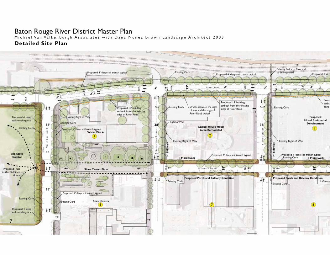
Shaw Center
Shaw Center Plaza
Arts and Science Museum
R i v e r R o a d
Centroplex Landscape
L a f a y e t t e S t r e e t
T h i r d S t r e e t
Centroplex Convention Center
USS Kidd Nautical Center
Proposed Garden Plaza
Future Development
Future Development
Future Development
Flo
rid
a S
tre
et
La
ure
l S
tre
et
Ma
in S
tre
et
Co
nv
en
tio
n S
tre
et
No
rth
Bo
ule
va
rd
Proposed Planting within the Waterworks
Street Trees
Median expanded to allow planting
Existing Parking Lot
Proposed crosswalk to connect to nautical center
Proposed Gate
Proposed Gate
Bus Parking
USS Kidd
R i v e r P r o m e n a d e
Proposed grove to frame historic building
and provide shade
21
9
3 4b
6
87
4a
Old State Capitol
Train exhibit
P r o p o s e d R i v e r P r o m e n a d e E x t e n s i o n
Parking Parking Parking
Proposed Paths
Proposed Paths
Proposed Pedestrian Traffi c Signal
5
R i v e r P r o m e n a d e
R i v e r P r o m e n a d e

0 30 60 120 240
N
The te Newspaper uilding
New Visitors Landscape
The Pentagon
Parking Garage
Future Desoto Park
T h i r d S t r e e t
State Capitol Landscape
Casino Rouge
Existing Street Trees
No
rth
Str
ee
t
Proposed pedestrian connection and traffi c signal at the new visitors center
River Road returns to existing four lane condition
Planting becomes looser to transition to the end of the Esplanade and allow wider views to Casino Rouge
Planting becomes denser to frame the entrance to Casino Rouge
Desoto Park Entrance
R a i l r o a d Tr a c k s
F u t u r e D e s o t o P a r k P a r k i n g
F u t u r e D e s o t o P a r k P a r k i n g
F u t u r e D e s o t o P a r k P a r k i n g
D e s o t o P a r k P a r k i n g
Annex Building
M I S S I S S I P P I R I V E R
Casino RougeParking
Entrance to Casino Rouge
StateCapitol
10
5
Visitors Center Parking
Proposed bus drop off
6
Baton Rouge River District Master PlanM i c h a e l V a n V a l k e n b u r g h A s s o c i a t e s w i t h D a n a N u n e z B r o w n L a n d s c a p e A r c h i t e c t 2 0 0 3
Detailed Site Plan
L a f a y e t t e S t r e e t
Flo
rid
a S
tre
et
Co
nv
en
tio
n S
tre
et
No
rth
Bo
ule
va
rd
R i v e r R o a d
Shaw Center
Shaw Center Plaza
Water Works
Capitol House Hotelto be Remodeled
ProposedMixed Residential
Development
42.09’
42.63’
53.0
’
45.6
45.1
’
46.7
’
43.0’
43.3’
32.5
’
32.5
’
32.5
’
52.5’
46.0
45.2
53.4
’
9.75’
12.0’
15’
9.8’
10.8’
9.2’
11.0
’
10.8
’
Lafayette
10.5’10.8’ 10.5’25.8’
22.0 ’
14.8 ’
Right of Way 38’
52’
38’
28’
28’
33’
33’ 33
’
38’
38’
14’ Sidewalk
2
3
6 7 8
Proposetbacedge o
Proposed 15’ building setback from the existing edge of River RoadProposed 15’ building
setback from the existing edge of River Road
Existing Right of WayExisting Right of Way
Existing Right of Way
14’ S
idew
alk
Old State Capitol 14’ Sidewalk14
’ Sid
ewal
k
Proposed Porch and Balcony Condition Proposed Porch and Balcony Condition
Existing Curb
Existing Curb
Existing CurbExisting Curb
Existing Curb
Existing Curb
Existing CurbExisting Curb
Existing Curb
Proposed 4’ deep soil trench typicalProposed 4’ deep soil trench typical
1
Proposed 4’ deep soil trench typical
Proposed 4’ deep soil trench typical
Proposed 4’ deep soil trench typical
Proposed 4’ deep soil trench typical
Proposed gate to the Old State
House
Existing CurbProposed 4’ deep soil trench typical Proposed 4’ deeProposed 4’ deep soil trench typical
Existing Stairs to Riverwalk to be improved
7
Width between the right of way and the edge of River Road typical

Proposed boardwalk connection to Desoto Park
L a f a y e t t e S t r e e t
No
rth
Str
ee
t
Ma
in S
tre
et
La
ure
l S
tre
et
Proposed Condominium Development
ProposedMixed Residential
DevelopmentThe Advocate
Newspaper Building
Parking Garage
45.0
’
45.8
’
45.0
’
45.0
’
47.0
’
45.1
’
45.3
’
42.6’
42.8’
42.1’
43.0’
42.8’
42.4’
31.9
’
33.0
’
32.5
’
32.5
’
32.8
’
32.5
’
32.5
’
32.5
’
32.5
’
9.5’
10.15’ 10.9’
9.8’
10.1’
10.2’ 10.5’
10.2’ 10.7’
11.0’
10.2’
10.5’
10.8
’
10.8
’
10.8
’
10.8
’
10.8
’
10.8
’
L a f a y e t t e S t r e e t
House
11.5’
13.1’
15.5’
16.1’
9.8’
Right of Way
38’38’ 38’
28’
28’
28’
33’
33’
33’
Possible Location ofGarden Plaza
Visitors Center Parking
To Desoto Park
4b 5
10
osed 15’ building ck from the existing of River Road
Proposed 15’ building setback from the existing edge of River Road
Proposed 15’ building setback from the existing edge of River Road
Existing Right of WayExisting Right of Way
14’ Sidewalk 14’ Sidewalk 14’ Sidewalk
14’ Sidewalk
14’ S
idew
alk
14’ S
idew
alk
Future Development
Future Development
Proposed 4’ building setback to provide space for street trees along entrance to garden plaza
Proposed 4’ building setback to provide space for street trees to frame entrance to Desoto Park
14’ S
idew
alk
14’ S
idew
alk
Existing Curb
Existing Curb Existing CurbExisting Curb
Existing Curb
Existing CurbExisting Curb Existing Curb
Proposed connection to riverwalk
Existing end of riverwalk
Proposed 4’ deep soil trench typical
Proposed 4’ deep soil trench typical
Proposed 4’ deep soil trench typical
p soil trench typicalProposed 4’ deep soil trench typical
4a
Existing edge of River Road
Existing Steps
9
Scale: 1”=30.0’0 15 30 60 120
8
Width between the right of way and the edge of River Road typical
Water Feature

Existing Conditions of Lafayette Street
Character sketch of the proposed conditions of Lafayette Street looking north9

A Pedestrian-Oriented Lafayette Street
Lafayette Street is conceived as the primary pedestrian spine linking the new Visitor Center and the Old State Capitol, and could one day become a vibrant urban street with a healthy mix of shops, restaurants, and apartments.
Road Adjustments
1. The roadway width should be reduced from 32’ to 28’ to slow traffic and allow more room for pedestrians and large street trees. This will create a 12’ center travel lane and two 8’ lanes of on-street parking. As development potential and the availability of parking facilities increase, the now 28’-wide Lafayette Street could be transformed to accommodate two way traffic by eliminating one lane of on-street parking and re striping the road for two 10’ lanes of traffic.
2. The additional 4’ allowance should be consolidated on the west side of the street to provide room for large, healthy canopy trees. The western sidewalk is chosen because of the currently planned development along the west side of the street and so as not to obscure the historic Lafayette building on the eastern sidewalk and allow this building typology to be expanded upon. It is critical to coordinate utility adjustments and recommended subsurface improvements contained within the Master Plan with the development of all parcels. Accordingly, the construction of the sidewalk would be timed in unison with the redevelopment of several parcels on the west side of the street: the Shaw Center and Shaw Center Plaza, the renovation of the Capitol House Hotel, and three adjacent residential developments. It is also important to note that because the sidewalk expansion and subsurface work is only recommended on one side of the street, therefore the amount of adjustments to utilities and infrastructure, should they be required during construction, will be significantly reduced. This will save money and simplify the design.
Sidewalk Materials and Character
3. Brick is recommended as the primary surface material for all Lafayette Street sidewalks, both to reduce the glare of the concrete streets and to echo the historic use of brick in downtown Baton Rouge. The use of a consistent species and spacing of street trees, lighting, and the warm brick surface will create a continuous linear element that will connect the new Visitors Center with the Old State Capitol and reinforce Lafayette Street’s pedestrian character.
4. The traditional balcony architecture of the Lafayette Building is unique to this region and should be encouraged along the east side of Lafayette Street. Repeating this historic building type will reinforce the pedestrian scale of the street and will offer much needed protection from the afternoon sun. It will also provide a charming complement to the large canopies of the street trees along the west side of the street. This sidewalk condition, characterized by a covered walkway and columns will also establish a comfortable boundary between pedestrian and vehicular traffic.
Lighting
5. Street lamps should be installed on the western sidewalk on direct axis of the center line of the street trees to reinforce the connecting gesture of the trees and to ensure the least possible interference with pedestrian traffic. Lighting along the eastern sidewalk of Lafayette should be attached to buildings, to keep this smaller sidewalk clear of obstacles that might interfere with pedestrian circulation.
Crosswalks
6. The Lafayette Street sidewalk should extend 8’ into and form “bump-outs” along the parallel parking lanes of the east-west streets connecting Lafayette Street to River Road. This will help to slow down east-west traffic, signal to the driver the presence of pedestrian crossing and direct traffic along the slight 2’ shift in the center line of the road. East-west crosswalks should be delineated with a simple, elegant material like granite. It is recommended that crosswalks not be brick, for both maintenance and safety reasons, and to allow for a more attractive interim condition as the sidewalks are incrementally improved. Bump-outs along Lafayette Street should not be constructed, to ensure that the street has the ability to become two-way. 10
A. Typical Lafayette Street Section - Existing
B. Typical Lafayette Street Section - Proposed

Street Trees
7. Street trees along Lafayette Street should be a native and fast growing deciduous canopy tree that will provide much needed shade in the summer and allow sunlight during winter. The trees along Lafayette Street should be highly limbed and a consistent species, and their spacing should remain a constant 30’ on center. The creation of a continuous and full canopy will help reinforce the continuity of the streetscape and emphasize the connection between the new Visitors Center with the Old State Capitol.
8. Planting trees as close to the sidewalk edge as possible in 4’ by 8’ tree pits will create a boundary between cars and pedestrians, allow the most room possible for the canopy to grow, and provide space for possible program opportunities such as outdoor dining along the sidewalks.
9. Continuous soil trenches of 4’ deep by 6’ wide, with proper drainage and irrigation, should be established free of utlities if possible. Soil trenches should contain a prescribed soil specified by a soil scientist and be created under all sidewalk conditions to ensure the best possible conditions for the trees to grow and mature over time.
A Garden Plaza Concept
10. Along Lafayette Street there are opportunities to create a special pedestrian-scaled outdoor plaza. The boundaries of this garden plaza could be shaped by the future buildings to create an “internal” pedestrian plaza that could take many forms. This Garden Plaza could be accessed by Lafayette Street and connecting streets as well as a possible connection to Third Street. This space would create a gathering and destination place within the downtown and could offer outstanding opportunities for outdoor dining, shopping, and nightlife. The acoustic qualities of a landscape space sahped by buildings, coupled with the warm climate of Baton Rouge, would also make this an ideal place for a water feature.
11. The success of the plaza as a vibrant and active urban space could be enhanced by requiring a 4’ setback for all future development from the Lafayette Street right-of-way. This would create a 14’ wide tree-lined sidewalk along on the east side of the street that would provide a visual cue to the plaza within. This would also create a shaded space for outdoor dining along Lafayette Street next to the garden plaza, and encourage program to spill out from the plaza to engage the pedestrians along Lafayette Street.
Precedent Image of the Edgemar Development. Santa Monica, California
Precedent Plaza image of Paley Park, New York
Precedent image of Bryant Park, New York 11
Plan Diagram of Edgemar Development. Santa Monica, California
Garden Plaza concept diagrams illustrating how the plaza could take on many forms and spatial arrangements
L A F AY E T T E S T R E E T
T H I R D S T R E E T
L A F AY E T T E S T R E E T
T H I R D S T R E E T
L A F AY E T T E S T R E E T
T H I R D S T R E E T

The Connecting Streets
12. With the exception of North Boulevard, the widths of the pedestrian streets should be reduced from 42’ to 38’. The 4’ should be added to north sidewalk to create a similar condition to that proposed for Lafayette Street, with a 14’ wide sidewalk and room for large street trees.
13. The northern sidewalk is chosen as the large tree-lined sidewalk because the south-facing side of the street provides the best growing conditions for the trees.
14. All connecting streets should become two-way in order to improve access and vehicular circulation into and around the area.
15. A recommended 4’ building setback is proposed along the southern sidewalk of North Street to allow room for street trees on both sides of the street. This double row of trees would frame the future main entrance to Desoto Park and help link the park to the city.
16. North Boulevard should be reduced to from 52’ to 40’ with 9’ of parking on both sides and capacity for bus parking. This would allow both sidewalks to be widened by 7’ and provide room for a grove of large street trees to be established down the center of the sidewalk. These would be the widest sidewalks in the River District and could become an extension of the mature grove of Live Oaks that now exist to the East along North Boulevard. These spacious pedestrian zones could function as a new front door to the Old State Capitol and connect the new River Road Esplanade, the Shaw Center Plaza, and North Boulevard.
C. Typical Connecting Streets Section - Existing
D. Typical Connecting Streets Section - Proposed 12

13
The River Road Esplanade The narrowing of River Road from a four lane 45’ roadway to a three lane 33’ roadway coupled with the proposed 15’ building setback and the narrowing of road widths, will create the conditions necessary to transform River Road into a dramatic riverfront esplanade and create a signature landscape at the edge of the city.
17. The trees along River Road should be a native, deciduous, fast growing, and very large canopy. With the exception of the segment above the park, the trees should be planted on axis at 30’ on center and respect the 6’ recommended setback from the edge of the road. Like Lafayette Street, it is critical that the proper subsurface soil conditions be established where trees are proposed. A continuous 10’ wide by 4’ deep soil trench with proper drainage and irrigation should be established throughout the entire length of the planting. The existing soil conditions should be assessed by a qualified soil scientist, to determine the need for the amendment to existing soils or the introduction of new soil profiles.
18. The Master Plan also calls for a new access point to the Riverfront Promenade via a new set of stairs at the levee at the end of Florida Street and the enhancement of the existing access points. The Florida Street access point would provide a needed connection at current the end of the Riverfront Promenade and help to create an urban walking loop. This new connection, as well as the existing access points, should be highlighted by crosswalks. These crosswalks should be made of a material consistent with that of the connecting sidewalks, which may be different than the brick of Lafayette, and reflect the change in elevation towards the river. The enhancement of access to the Riverfront Promenade will work with the current plans for extending the Riverwalk via a boardwalk, and will strengthen the connection between Desoto Park, the Riverfront Promenade, and the city.
19. The light posts with a similar character to those used on Lafayette should be used on River Road along the segment from Desoto Park south to the Convention Center area to help unify the district. The spacing should be approximately 60’ on center and should be aligned on the same axis as the trees. This will add another unifying element with-in the district and reinforce the new pedestrian-oriented character. As River Road moves north of Desoto Park, the introduction of a larger scale lighting element more consistent with what is used north of the project area is recommended to help establish a smooth transition into the existing conditions.
20. Although preliminary research on utilities has been done during this survey, it is highly recommended that a detailed utility survey be conducted to assess any situations that may require the relocation of existing underground utilities. The Master Plan also recommends that planting of the east side of River Road be coordinated with the currently planned developments. Along with the obvious advantages mentioned earlier, this will help to avoid the challenge of protecting trees during the construction of these new buildings.
River Road from North Street to North Boulevard
21. River Road should become two lanes with an alternating turning lane. Traffic lanes along River Road are to be a aximum of 11’. Narrowing the roadway creates a continuous 12’ planting zone along almost all of River Road. A concrete curb and gutter along the street edge will help protect the new trees and create a defined street edge.
22. The street trees along the levee should be complimented with a parallel row of trees, planted within the 15’ building setback, along the eastern edge of River Road.
23. The current space available for planting along the east side of River Road is between the edge of the roadway and the right-of-way. This space between North Boulevard and North Street varies from 9.8’ to 22’. A minimum of 15’ of space is required to accommodate a sidewalk and provide adequate room to grow the large canopy trees that will complement the planting on the west side of the street. The space required for planting a continuous row of trees can be created by requiring all new buildings to be set back 15’ from the roadway, accommodating the space necessary to plant a single row of large deciduous trees and a 4’ sidewalk adjacent to the building edge.
24. It is critical in establishing the experience of a tree-lined boulevard that the row of trees on both sides be interrupted as little as possible. For this reason the Master Plan recommends that all vehicular access to the developments be located on connecting streets rather than on River Road.
25. A 4’ sidewalk should be installed along the western edge of the 15’ building setback to allow for pedestrian movement along River Road while also giving the trees the most room to grow. In some cases the sidewalk will need to be built within existing property lines. Permission to build the sidewalk within existing property boundaries should be included within the 15’ building setback agreement.
River Road by Desoto Park
26. Taking advantage of the wider right-of-way along the River Road north, a double row of trees is proposed along the segment adjacent to Desoto Park. The thickening of planting along the park’s edges will create a front door to the park while framing views and entrances. These trees should be highly limbed to allow views under the canopies into the park.
27. The four proposed pedestrian crosswalks across River Road should all be indicated by a change in materials in the road surface. These include two crossings at North Street on the north and south sides of the intersection, a crossing at the new Visitors center that should be indicated with a traffic signal, and a crossing at the northern intersection at the exiting traffic signal.
28. To the North of Desoto Park, the formal arrangement of trees should begin to loosen and take on a more random or natural configuration as it blends back into the existing conditions, with the exception of the area around the entrance to Casino Rouge, which should have denser planting to frame the entrance.
River Road by the Convention Center and Old State Capitol
29. The concentration of cultural uses and the intensity of pedestrian use in this area will create a section of River Road with a much different treatment than the sections to the north.The existing three lanes of travel should be reduced to two lanes with on-street parking where appropriate.
30. Two raised pedestrian crosswalks are proposed to connect the Convention Center to the Arts and Science Museum and the USS Kidd Nautical Center.The edge condition of River Road will change in character from a robust esplanade along the levee segment should shift to a more pedestrian-oriented condition with a mix of wide sidewalks, large canopy street trees, and parallel parking.The introduction of urban street trees into this segment will humanize the scale of the adjacent architecture and provide much needed shade.
31. The small concrete median at the Convention Center drop-off area should be widened and designed to allow for street trees to meet the grove and to create a link between the green space of the Convention Center landscape and the Old State Capitol. This will frame River Road and distinguish it from the Convention Center drop-off area. The street trees should extend around the corner of Government Street to create a gateway experience to the River Road Esplanade.
32. Although the Old State Capitol is not within the scope of this study, the master plan recognizes this parcel as a critical missing link needed to create a coherent and useable pedestrian circulation system in Baton Rouge. The proposal recommends that openings be created within the existing historical fence. A proposed opening on North Boulevard aligned on axis with Lafayette Street will connect the new Shaw Center Plaza with the Old State Capitol and create a welcoming gesture through this cultural landscape. Openings along the south fence will join the Convention Center Landscape and the Old State Capitol, providing the needed link to the downtown pedestrian circulation system. It is very important that all new paths be delicately introduced into the topography of this historic landscape in a way that complements and respects the historic condition.
33. The Master Plan also recognizes the opportunity to enhance to the planning within the Old State Capitol to improve views of the historic building and landscape, provide greater abundance of shade for the new pedestrian traffic, and frame and reinforce the formal qualities of the original design.

14
E. Typical River Road Section - Existing
F. Typical River Road Section from North Boulevard to North Street- Proposed

15
Existing Conditions of River Road

1216Character sketch of proposed conditions of River Road looking north

Capitol House Hotel ProposedMixed Residential
Development
LA Corps of Engineers
Water Works
15’ building setback from existing edge of River Road to allow room for trees and sidewalk on east side of road
15’ building setback from existing edge of River Road to allow room for trees and sidewalk on east side of road
15’ building setback from existing edge of River Road to allow room for trees and sidewalk on east side of road
15’ 15’ 15’15’
15’
33’33’33’33’
Existing CurbExisting Curb
28’
14’
38’ 14’38’ 14’ 10’10’38’
Proposed Balcony ArchitectureProposed Balcony Architecture
Existing edge of River Road
Existing edge of River Road
Existing CurbExisting Curb
Existing Curb
Existing Curb
Baton Rouge River District Master PlanM i c h a e l V a n V a l k e n b u r g h A s s o c i a t e s w i t h D a n a N u n e z B r o w n L a n d s c a p e A r c h i t e c t 2 0 0 3
Building Setbacks and Road Adjustments Plan
Extent of Existing Right of Way
Building Setback
Flo
rid
a S
tre
et
Co
nv
en
tio
n S
tre
et
No
rth
Bo
ule
va
rd
L a f a y e t t e S t r e e t
R i v e r R o a d
17
Varies (min. 12’)Varies (min. 12’)Varies (min. 12’)Varies (min. 12’)

ProposedMixed Residential
Development
Proposed Condominium Development
The Advocate Newspaper Building
Visitors Center Parking
LA Corps of Engineers
15’ building setback from existing edge of River Road to allow room for trees and sidewalk on east side of road
15’ Building Setback from existing edge of Lafayette Street to allow for street trees at entrnace of Lafayette Garden Plaza
14’ building setback from existing edge of North Street to allow room for double row of trees to frame en-
trance to park
15’ building setback from existing edge of River Road to allow room for trees and sidewalk on east side of road
15’15’ 15’
15’
15’
15’
15’ 15’
15’
33’ 33’33’33’
33’33’
15’ building setback from existing edge of River Road to allow room for trees and sidewalk on east side of road
Varies (min. 12’)
28’
14’Existing Curb Existing Curb Existing Curb
28’
14’
28’
14’
28’
14’
38’ 14’ 38’ 14’38’ 14’10’ 10’ 14’
Possible Locationof Garden Plaza
Existing edge of River Road
Existing edge of River Road
Existing edge of River Road
Existing Curb Existing CurbExisting Curb
No
rth
Str
ee
t
Ma
in S
tre
et
La
ure
l S
tre
et
L a f a y e t t e S t r e e t L a f a y e t t e S t r e e t
R i v e r R o a d
R i v e r R o a d
18
Varies (min. 12’) Varies (min. 12’)Varies (min. 12’)
Varies (min. 12’)

1919
No
rth
Bo
uld
va
rd
Go
ve
rnm
en
t S
tre
et
B e a u r e g a r d To w n
O l d S t a t e C a p i t o l
C e n t r o p l e xS h e r a t o n
H o t e l
S h a w C e n t e r f o r t h e A r t s
S h a w C e n t e r P l a z a
R i v e r R o a d

2020Aerial Diagram of Downtown Baton Rouge 20Context Diagram of the New River District of Baton Rouge
L a f a y e t t e S t r e e t
D e s o t o P a r k
R i v e r R o a d
T h i r d S t r e e t
F o r t h S t r e e t S t a t e C a p i t o l L a n d s c a p e
S p a n i s h To w n
M i s s i s s i p p i R i v e r
N e w V i s i t o r ’ s C e n t e r
R i v e r R o a d
S t a t e C a p i t o l

Michael Van Valkenburgh Associates, Inc.18 East 17th Street, 6th FloorNew York, NY 1003p. 212.243.2506 f.212.243.2016mvvainc.com